il - smithsonian institution
TRANSCRIPT
ATOLL RESEARCH BULLETIN
NO. 360
OCCURRENCE OF PHOSPHATE ROCK AND ASSOCIATED SOILS IN
TUVALU, CENTRAL PACIFIC
BY
IL A. ROGERS
ISSUED BY NATIONAL MUSEUM OF NATURAL HISTORY
SMITHSONIAN INSTITUTION WASHINGTON, D.C., U.S.A.
MAY 1992
OCCURRENCES OF PHOSPHATIC ROCK AND ASSOCIATED SOILS IN TUVALU,CENTRAL PACIFIC
by K.A. RODGERS
Abstract: Phosphatic limestones and associated soils occur on eight of the nine islands of Tuvalu, central Pacific.
Deposits range from gram-size to >500,000 tons. Carbonate hydroxyapatite, dahllite, forms crustose cement about calcareous bioclasts which it sometimes replaces. Precise genetic relationship of rock to soil is unclear. Consolidated rock occurs as hardpan within phosphatic soil profiles, with unconsolidated phosphatic layers above and below. Phosphatization has occurred either as a continuous or episodic process within the vadose zone for at least 4000 years. Present outcrops are exhumed accumulations of apatite formed in vadose zones corresponding to earlier, higher sea levels. A geobotanical relationship between the Tuvalu phosphate deposits and Pisonia grandis can not be sustained on present evidence and the tree should not be regarded as a geobotanical indicator today.
INTRODUCTION
Phosphatic limestones and associated soils occur on at least eight of the nine islands of Tuvalu, central Pacific. They range from slight phosphate crusts affecting no more than a few grams of limestone to deposits of >500,000 tons. As with similar low island occurrences, the Tuvalu phosphates are distinct from the massive deposits found on raised atolls and islands such as Ocean Island and Nauru; the two groups differing in occurrence, texture, mineralogy and chemistry (cf. Altschuler, 1973; Stoddard and Scoffin, 1983).
Recent studies in Tuvalu have yielded new information concerning the phosphatic limestones of all islands. Much of this new data is not widely available, existing in unpublished files and limited circulation, mimeographed reports. A summary of some of this information has been given by Rodgers (1989a) and it is proposed to provide here detailed descriptions of the various occurrences along with observations on the present geobotanical relationships of the deposits with Pisonia grandis in Tuvalu.
Department of Geology, University of Auckland Private Bag, Auckland, New Zealand
Manuscript received 30 September 1988; revised 16 July 1991
TERMINOLOGY
Two types of "guano" phosphates have been identified on low islands and atolls (Hutchinson, 1950; Tracey, 1980):
(i) phosphatic or ancient guano which was the primary target of the nineteenth century guano miners. This is regarded as avian guano which has lost its volatiles and is found primarily on arid islands in the equatorial dry belt which receive less than 1000 mm of rain per year;
(ii) cemented, or atoll phosphate or crust guano - a honey brown phosphate which cements and replaces carbonate sand and gravel of the atolls. It is more widespread than phosphatic guano and occurs on both wet and dry islands, being common on those which receive between 2000 and 4000 mm of rain.
The relationship between the two types is not clear cut and the two may not be discrete (cf. Altschuler, 1973; Stoddart and Scoffin, 1983).
All Tuvalu phosphate deposits described to date belong to the second category but, as an avian origin for the Tuvalu deposits has not been demonstrated, terms which have genetic connotations, or which have been used with such connotations, will be avoided. Where a general term is required, the descriptive crustose phosphate, phosphatic crust, or phosphatic limestone will be used with no origin implied or assumed.
The term phosphorite (cf. McConnell, 1950; American Geological Institute, 1974) is inappropriate for most of the Tuvalu phosphate-bearing rocks. Few are composed essentially of apatite or other calcium phosphate. Nor does phosphatite (Slansky, 1980) apply to the majority. The modal per cent of phosphate varies widely from slightly phosphatized limestones to rocks which contain over 50% collophane. In only a few rocks does P,O, exceed 18%, corresponding to 50 wt% carbonate-apatite. Calcium carbonate is the dominant species of most specimens examined. As such, terms such as phosphatic limestone or phosphatic biocalcarenite and phosphatic biocalcirudite (cf. Scolari and Lille, 1973; Slansky, 1980) are most appropriate.
The primary phosphate mineral found in the Tuvalu deposits is dahllite, carbonate hydroxyapatite (Rodgers, 1987, 1989a,b).
McLean et al.,' (&ious dates) used the soil classifications and terminology of FAO- UNESCO Soil Map of the World (1974, 1978) to describe and map the soils of Tuvalu. The same nomenclature is followed here; the dominant soil types being Calcaric Regosols (Rc): very weakly developed soils on coral sand and rubble. Variations exist according to substrate grain size, depth of soil cover, presence of indurated layers, salinity and alkalinity. Phosphatic soil is one of three minor types.
It should be noted that the relationship of phosphatic soil to unconsolidated phosphatized sediment, and to cemented phosphate rock is such that any distinction between soil and rock may be artificial. Many of the soils described by pedologists in Tuvalu are the same materials which geologists have characterized as unconsolidated sediments and sedimentary rocks. Thus the "phosphatized sands" described and mapped by White and Warin (1964) are the "phosphatic soils" of McLean et al., (various dates) and, insofar as the "phosphatic soils" contain cemented horizons, they are synonymous in part with Radke's (1986) "phosphatic limestones." No attempt has been made to map soil and rock as physically separate entities by any field worker in Tuvalu.
TUVALU - HISTORY OF RESEARCH
Tuvalu consists of nine small atolls and reef islands situated between 5" and 10.5"s latitude and 176" and 179.8"E longitude. From north to south the islands are Nanumea, Niutao, Nanumaga, Nui, Nukufetau, Vaitupu, Funafuti, Nukulaelae and Niulakita. The roughly linear archipelago is part of the Ellice-Gilbert-Marshall chain (cf. Morgan, 1972) and is the surface expression of thick carbonate carapaces draped over extinct volcanic mounds (Gaskell, Hill and Swallow, 1958). No part of any island exceeds 8 m elevation above sea level. Volcanic rocks dredged from the flanks of Niulakita are Cretaceous (Duncan, 1985).
Crustose phosphate deposits were exploited from Niulakita between 1899 and 1902 (Cochet, 1900; Becke, 1906). Small phosphate occurrences were described from the islets of Amatuku and Fongafale in reports of Royal Society expeditions conducted in 1896, '97, '98, concerned with deep drilling operations on Funafuti (Cooksey, 1896; Judd, 1904; Sollas, 1904). None of these deposits merited mention in Hutchinson's (1950) comprehensive review, and following the fall of major Pacific phosphate islands to the ~apanese in World War 11, the ElliceEuvalu occurrences were discounted as an alternative source of supply (Archives, High Commissioner, Western Pacific).
As part of a general assessment of the phosphate resources of the western Pacific by the Australian Bureau of Mineral Resources, White (in White and Warin, 1964) visited all islands of ElliceEuvalu except Niulakita whose deposits he believed to be exhausted. He reported new findings of crustose phosphate from Nui (3000 tons), Nukufetau (5000- 10000 tons) and Vaitupu (10000 and 25000 tons) all in the range 10-20% P,O, (cf. Warin, 1968). It is these deposits which are figured in reviews of Pacific phosphates (e.g. Cook, 1975; Lee, 1980; Aharon and Veeh, 1984; Cullen, 1986). White also noted a number of minor occurrences of phosphatic limestones throughout the archipelago.
A 1976, pre-independence report on prospects for agricultural and industrial development in the group by U.K. Ministry of Overseas Development included the first

TABLE 1. Summary of Climatic Data for Islands of Tuvalu
Island Lat. Temperature Annual rainfall (mm) Long. mean daily monthly mean max mean min max min
Nanumea
Niutao
Nanumaga
vaitupu
Nui
Nukufetau
Funafuti
Nukulaelae
Niulakita
29.9-30.8 24.9-25.3 27.5-28.1
29.9-30.6 24.9-25.3 27.5-28.1
29.9-30.6 24.9-25.3 27.5-28.1
30.2-3 1.1 24.8-25.4 27.6-28.1
30.2-3 1.1 24.8-25.2 27.6-28.1
No temperature data available
30.2-3 1.1 25.0-25.5 27.7-28.2
No temperature data available
30.9-3 1.8 24.4-25.0 27.8-28.5
description of the phosphatic rock of Niulakita (Flynn and Makin, 1976) but lacked essential geological detail.
The most significant contribution to understanding the extent of the Tuvalu phosphates resulted from land resource surveys prepared by Professor Roger McLean and co-workers for the United Nations Food and Agricultural Organization. Reports on each island include large scale maps showing geomorphic zones, soils and vegetation. These provided the first scientific cartography of ElliceDuvalu since the Royal Society Report of 1904 which was confined to Funafuti. Numerous soil profiles are documented, along with chemical and physical parameters. Copies of these reports are not widely available. The island descriptions presented below draw heavily on McLean7s maps and data for seven of the islands. A partial report on Vaitupu was available in draft form only. No similar survey of Funafuti had been prepared at the time of writing.
Several investigators have looked for deposits of phosphates beneath the lagoon and reefs of the group: Warner and Rossfelder (1978) at Nanumea, Nanumaga, Nui and Vaitupu, Sahng-Yup (1981) at Funafuti and Radke (1985, 1986) at Nukufetau. No such deposits have been found but Radke's reports contained some petrographic detail of samples taken from terrestrial outcrops. Rodgers (1987, 1989a,b) identified the principal phosphate mineral present in Tuvalu as dahllite and found whitlockite in indurated surface outcrops.
Climate is regarded as exercising an important role in the occurrence of low island phosphates (Hutchinson, 1950: Tracey, 1980). The summary of temperature and rainfall data of Table 1 comes from sources given in Rodgers and Cantrell (1987).
Geographic names used on each island have varied over the years, as has their spelling. Those given here are current local usage. Former names are sometimes shown in brackets.
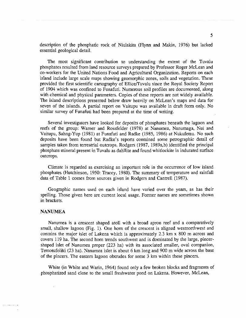
NANUMEA
Nanumea is a crescent shaped atoll with a broad apron reef and a comparatively small, shallow lagoon (Fig. 1). One horn of the crescent is aligned westnorthwest and contains the major islet of Lakena which is approximately 2.3 km x 800 m across and covers 119 ha. The second horn trends southwest and is dominated by the large, pincer- shaped islet of Nanumea proper (223 ha) with its associated smaller, oval companion, Temotufoliki (23 ha). Nanumea islet is about 6 km long and 900 m wide across the base of the pincers. The eastern lagoon obtrudes for some 3 km within these pincers.
White (in White and Warin, 1964) found only a few broken blocks and fragments of phosphatized sand close to the small freshwater pond on Lakena. However, McLean,
NANUMEA
5O39'- 5
N 0
P&;. Phosphatic limestone,scattered blocks and soils. * Individual Pisonia g rand is
q t l t 1500m
FIG. 1. Locality map, Nanumea. After McLean, Holthus, Hosking and Woodroffe
___- -------___ ,----
I '--------, 177°18'E
I' --. I' ----* -- --_ N l UTAO
p <:.::. ... Reported phosphatic soil Pisonia absent
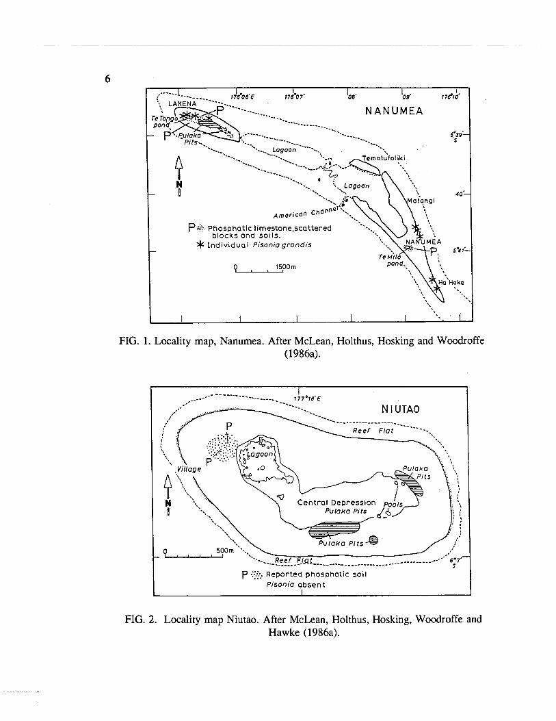
FIG. 2. Locality map Niutao. After McLean, Holthus, Hosking, Woodroffe and Hawke (1986a).
Holthus, Hosking and Woodroffe (1986a) mapped some 20 ha of phosphate soils covering 5.5% of the atoll's land surface.
On Nanumea islet, several blocky outcrops of phosphatic calcirudite and associated soils, which extend to 20-30 cm depth, occur beneath Thespesia woodland surrounding Te Milo pond. Phosphate in this area is restricted to the margins of this basin and outcrops atop abrupt slopes bounding the pond.
Two areas of phosphatic soils occur on Lakena. Both extend west of the pulaka (taro) pit area across the inner slopes of a coastal ridge and the edges of a central depression. They are separated by a zone of dark, sandy soil containing patches of sparse phosphatization. Soil profiles in both areas show an abrupt boundary between top soil and parent sediment at a depth of 25-30 cm (McLean et al.,, 1986a). Towards Te ong go, the surface is littered with blocks of consolidated phosphatic limestone mixed with calcareous gravel. Close to Te Tongo are sandy phosphatic soils, presumably those noted by White. Only on Lakena is Pisonia grandis found growing on phosphatic soils; three trees in all.
NIUTAO
Niutao is a small, 2.5 x 1.15 km reef island occupying nearly 80% of the available reef top, with its coast paralleling the unbroken, roughly oval, reef edge and its long axis oriented westnorthwest-eastsoutheast (Fig. 2). The island is saucer-shaped with a central depression occupying some 57 ha and containing a small lagoon and swamps in the west and a gravel covered hardpan in the east. This depression was probably a lagoon, now isolated from the sea by the surrounding sand and gravel ridges. Total land area is about 235 ha.
The island is notable in lacking any Pisonia or any other substantial broadleaf woodland as well as any mature Pisonia trees (McLean, Holthus, Hosking, Woodroffe and Hawke, 1986a). White (in White and Warin, 1964) found no phosphate. On the basis of information provided by residents, McLean et al., (1986a) mapped but did not visit an area of phosphatic soils northeast of the village where small specimens of Pisonia were also believed to be sprouting. Searches by Dr Urslua Kaly in 1990 failed to find any phosphatic limestone outcrops in this area or elsewhere on the island (pers. corn., September 1990).
NANUMAGA
Nanumaga is a roughly oval, 3 x 1.5 km, reef island surrounded by an unbroken fringing reef and occupying some 77% of the available reef top (Fig. 3). The island's surface is saucer-shaped with a broad central depression occupied partly by small lagoons and ponds which, along with their swamp margins, cover some 57 ha. Maximum elevation is about 8 m on the western lee edge. Total land area is some 282 ha.

I * lndividuol ~ i s o n i o ~ m n d b ' - ] '. , I I --___.
FIG. 3. Locality map Nanumaga. After McLean, Holthus, Hosking and Woodroffe (1985).
White (in White and Warin, 1964) reported no traces of phosphatization either on the surface or in several auger holes drilled to 2-2.5 m but McLean, Holthus, Hosking and Woodroffe (1985) mapped two areas of phosphatic soils covering about 13 ha. The largest extends eastward from the village to the mangrove fringe of Vaiatoa Lagoon. The second skirts this lagoon's northern shore. Both demarcate major concentrations of loose phosphatic limestone blocks which litter the surface and extend to a depth of 15-30 cm in a matrix of dark, phosphate-coated, ill-consolidated, calcareous sands and gravels. Coherent crusts of phosphatic limestone are exposed only rarely on the surface.
Pisonia woodland is absent from Nanumaga, the only Pisonia present being a few isolated individuals in the northwest. Thespesia is also generally absent.
VAITUPU
Vaitupu is an elongate, roughly pear-shaped island about 5.6 x 3.2 km, with its long axis lying northwest-southeast, and surrounded by a broad fringing reef (Fig. 4). There are two, small, shallow lagoons, Te Loto in the north and Te Namo in the south. Both are bordered by wide flats of fine calcareous mud.
Two large areas of phosphatic rocks and soils have been recognized on Vaitupu by both White (in White and Warin, 1964) and McLean, (pers. com. 1987). The first occurs near the center of the island about midway between the two lagoons. It consists of a phosphatic biocalcarenite crust ranging from a few centimeters to half a meter thick and covering an area of 8.17 ha. Variable-sized, mottled blocks of phosphatic biocalcarenite are scattered through a rich dark loamy crumb-structured soil. In places, similar blocks extend to a depth of more than half a meter in clean calcareous sand. PisonialHernandia broadleaf woodland covers much of the area which also includes part of the Agricultural Department experimental station. White estimated a total of 25,000 tons of phosphatic rock were present, averaging 20% PP,O,, although his figures appear to be based on a smaller areal extent of outcrop (-6 ha) than mapped by McLean.
Patchy phosphatization affects an area of about 5.5 ha on the eastern shores of Te Namo where it extends to a depth of 50 cm. White described the affected calcareous sediment as finer grained and more compact than at the other deposit and containing much broken shell and fine coral. McLean (pers. com. 1987) however, found an abundance of coral gravel and mapped the area as "phosphatic gravelly sands", in contrast to the northern sandy phosphatic soils. Tonnage was estimated by White as half that of the northern deposit.
White considered Vaitupu as the most productive of the Ellice Islands. In large part he believed this reflected the presence of an extensive, albeit thin covering of phosphate. However, it should be noted that by the early sixties when White visited, Vaitupu had become a show piece of the Ellice Islands due mainly to an intensive program of work

a- --, VAl TUPU
/' '--
FIG. 4. Locality map Vaitupu.
- Individual Pisonio
g rand is Broad leof woodlond I
'lIIU'including o Pironia / component ;
i P:.:.:.~ajor oreas of :
. ' phosphatic : limestone and soil. :
, i 6, Unimai .'
j Lagoon i mp / oKokoIe {
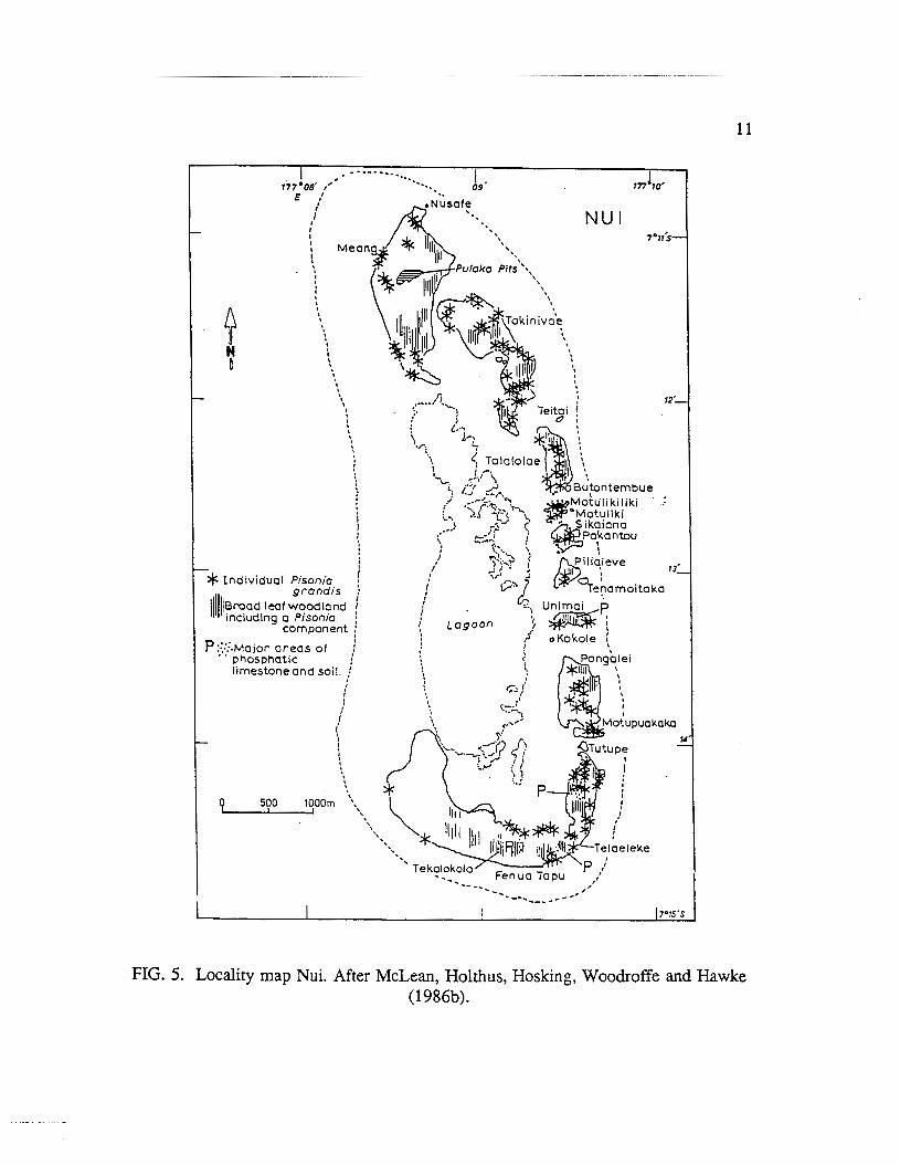
FIG. 5. Locality map Nui. After McLean, Holthus, Hosking, Woodroffe and Hawke (1986b).
instituted to repair the ravages of World War I1 (Lifuka, 1978, pp. 102-3, footnotes 6,7). The result was in sharp contrast to the still damaged appearance and agriculture of the other islands (e.g. Luomala, 195 1; Tudor, 1966).
Nui is an elongated, crescentic atoll about 7.25 x 2.5 km with its long axis oriented north-south (Fig. 5). Land area is 351 ha comprising 18 separate islets spread in a chain around the atoll's northern, eastern and southern sides. Fenua Tapu in the south accounts for 40% of this land area with Meang in the north contributing a further 25%. The western side of the atoll consists of a bare reef flat, 600-1000 m wide, and exposed at low tide. The lagoon is comparatively small and lacks any direct passage to the sea.
McLean, Holthus, Hosking, Woodroffe and Hawke (1986b) observed that the most mature soils of Nui - including the phosphatized horizons - occur in the central flat and surrounding ridge areas of the larger islets. These authors mapped three areas -of phosphatized soil on Fenua Tapu, the largest being at Te Kolokolo. The parent rock is a coarse, calcareous, semi-consolidated calcirudite containing sandy lenses and forming part of the older ridges of the interior of this islet. Broken blocks of consolidated, botryoidal, phosphatic limestone are scattered across the ground surface and extend to a depth of 20- 30 cm with occasional blocks being found to 60 cm. McLean et al., reported that the parent material below is substantially unmodified, but White (in White and Warin, 1964) had described this deposit as dffering from those examined elsewhere in Tuvalu in having its base "everywhere gradational into the underlying sands" (p.89) -and he interpreted this as a consequence of the thick cover of "salt brush" keeping the phosphatized zone in a permanently moist state and promoting the downward leaching of the phosphate. Twenty years later, Woodroffe (1985) described the cover as being dominated by tall Pisonia, many reaching 20m, with Ficus, Morinda and Acalypha being important and the ferns Nephrolepis, Polypodium and Asplenium occurring as groundcover. Pisonia trees have been extensively felled in this area but regrowth is occurring from fallen limbs. White gave the dimensions of the Te Kolokolo deposit as approximately 90 x 75 m with an average thickness of 25 cm. He estimated 3000 tons were available containing 10-15% P205.
Two further, smaller deposits occur on Fenua Tapu. The substrate of both is calcarenite. That at Telaeleke occurs beneath an impressive stand of Pisonia woodland.
Incipient development of phosphate in areas of dark soils was noted on Fenua Tapu by McLean et al., (1986b) as well as on the islets of Meang and Unimai. In total, these workers mapped 3.07 ha of phosphatic soils on Nui, representing 0.87% of the land surface.
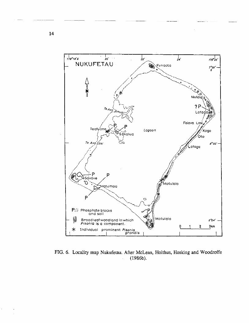
NUKUFET AU
Nukufetau is a rectangular atoll, 14 x 8.25 km, with its long axis oriented northeast- southwest. 85% of the reef platform consists of bare reef flat (Fig. 6). Total land area of 331 ha comprises 37 separate islets with a narrow, almost continuous strip of land forming the southeastern side of the atoll. Two reef passes, Te Ava Amua and Te Ava Lasi, connect the lagoon to the open sea.
White (in White and Warin, 1964) reported phosphatized sand covering much of the surface of Sakalua (Coal Island), a small sand bank near the lagoon entrance. This deposit was subsequently mapped by McLean, Holthus, Hosking and Woodroffe (1986b) and investigated briefly by Radke (1985,1986). The islet measures 300 x 150 m and reaches no more than 1.5 m above sea level. 3.45 ha of the surface is covered by a crust of phosphatized calcarenites and calcirudites which averages 15-20 cm thick but commonly extends up to 30 cm deep. While the crust is fairly uniform in appearance, it is somewhat patchily developed beneath Thespesia scrub. White (p.92) interpreted the uneven development as "indicating that the original guano deposition was not uniform over the entire island". A central depression on the islet is floored by muddy phosphatic soil which renders it sufficiently impermeable to hold water after rain. At the margins the crust passes into calcareous beach rock and in an eroded section through the crust on the south- eastern shore of the islet, Radke (1986) described solution depressions in the underlying limestone as rimmed and partially infilled by dark phosphate. Phosphate levels were highest in the top of the section (61% Ca,(PO,),), passing to 49-41% below.
Radke (1985, 1986) reported phosphatized limestone from Savave, from the' reef flat east of Teafoune, from the reef flat to the north of Motumoa, central Motumoa, and believed it to occur also on Lafaga. McLean et al., (1986b) also mapped an area of 2.9 ha on the western side of Motulalo where phosphatic soils are patchily developed within an area of otherwise dark soil covered by Hernandia woodland.
Following his 1985 survey, Radke considered that Nukufetau was one of the more likely of Tuvalu's islands to have submarine phosphate deposits within the lagoon, the floor of which extends to a maximum depth of 30 m. Subsequently, he conducted a seismic survey and located two major reflectors, both of which he interpreted as unconformities within the lagoon sediments (Radke, 1986). The shallowest of these occurs 4-12 m below the lagoon floor and is possibly associated with surface lag deposits contained in erosional channels. The second lies 10-40 m lower is related to two large bodies, presumably of sediments, occurring lagoonward of Te Ava Lasi and Faiava Lasi- Lafaga-Niuatui. No subsequent work has been undertaken to ascertain if phosphatic lag- gravels form part of these deposits.
Lagoon
P::.. Phosohate blocks - - - - and soil ....
- 11/11) Broodleaf woodland in which ". a004' - Pisonia is a component.
P 1 2 3km * Individual prominent Pisonia grandis I
FIG. 6. Locality map Nukufetau. After McLean, Holthus, Hosking and Woodroffe (1986b).
Te Avo i te Lope
N ,, = =-c2 I I
0
Fualifeke
. < Te Avo Mateiko ::
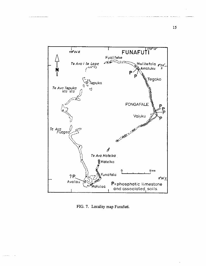
FIG. 7. Locality map Funafuti.

FUNAFUTI
Funafuti is the largest atoll of the group, being roughly pear-shaped, with its narrow- end directed south (Fig. 7). The lagoon is 16 x 13 km and approximately 45 m deep. It is surrounded by some thirty islets, a number of which form an almost continuous line on the eastern (windward) side; the longest being Fongafale which extends over 11 km.
Phosphatic rocks and a soil sample from Funafuti were collected during the first Royal Society coral reef boring expedition of 1896 and reported on by Cooksey (1896), David and Sweet (1904), Judd (1904) and Sollas (1904). These appear to have come from three localities. No similar soils or rocks were described from collections made during the 1897 and 1898 expeditions.
Judd (1904, p.372) described a dark brown rock "obtained by professor'^^^^^^ from behind the Mangrove Swamp near Fongafale in the main island of the atoll". Two analyses yielded 21.74 and 29.07% "calcium phosphate". It may be noted. that geographic usage in the Royal Society's report differs from that of the present day. "Funafuti" was used in the report for both the atoll itself as well as the main islet of that atoll. "Fongafale" was regarded as the main center of that islet. Present usage has Fongafale as the main islet of the atoll of Funafuti.
The locality of Judd's samples was close to a "taro plantation" from which Hedley had collected a soil, an air dried sample of which Cooksey (1896, p.76) had found to contain 6.00% P205 and had concluded "would seem to shew that a considerable quantity of animal matter, either in the shape of bones or excrement has been added to this soil as manure". David and Sweet (1904, p.68) commented that this soil had perhaps had a certain amount of "guano" added to it but it "should be mentioned that the soil ... has been enriched in places by material carried there by natives from other islets in this atoll, and we were informed that a little of the soil had been bought over as ballast from Samoa."
The taro plantation referred to was presumably the main pulaka (taro) pit on Fongafale dug to the local water table. The ground around this and similar dug pits elsewhere in Tuvalu is littered with spoil. The soil within is little more than a poorly drained calcareous ooze with a high organic content due to its being regularly mulched with vegetable refuse. Phosphatic rock and soil has been added to such pits in an attempt to improve productivity for at least a hundred years, on an unsystematic and irregular basis. Hedley may have fortuitously sampled a soil that had been artificially enriched but small outcrops of phosphate rock occur in several places on Fongafale and trenches, opened to a depth of 2 m for the laying of power reticulation cables in the northern part of the main township, frequently encountered patchy phosphate deposits. Field investigations by the author in 1984, 1986 and 1988 indicate that a thin but extensive subsurface crust of phosphate exists in this area of Fongafale near the site of the 1897-98
Royal Society bore hole. Perhaps it was this deposit which was exposed in and alongside the pulaka pit in 1896 as well as "behind the mangrove swamp."
Judd (1904) reported on two other specimens of brown phosphatic rock collected by Sollas from "the islet of Avalau, lying north of the main island of Funafuti" (p.372). Again there is geographic uncertainty. Avalau is an islet at the extreme south of Funafuti. Sollas (1904), however, described phosphate-rich rock from Arnatuku islet, in the north of Funafuti. Possibly this was where Judd's specimens came from. The two yielded 14.40 and 26.34% "calcium phosphate"; the brown mamx containing 32.5% and the white limestone fragments within the mamx 5.79%.
The Amatuku deposits outcrop just short of the western tip of that islet. Rodgers (1989b) described the greatest thickness as occumng on the lagoon beach where phosphatic limestone extends from beneath the low tide zone to the top of the islet's 1.5 m terrace on which a jumble of broken phosphatic blocks extends across the 20 m width of the island. On the ocean coast the phosphatized horizon is less than half a meter thick and confined to the supratidal terrace. Sollas (1904) described the beds on the lagoon coast as forming a low cliff rising "5 feet above high-water springs. In places they are undercut and fallen fragments lie on the lagoon platform. The dip of the beds is a few degrees (3" to 4") to the W.N.W." (pp.24-5). The cliff is now eroded and phosphatic limestone occurs as small phosbergs (Stoddard and Scoffin, 1983) within a gravel strewn beach. The rocks alternate between biocalcarenites and biocalcirudites in which the clast size is variable but commonly between 8 and 30 rnm dia. Sollas regarded the beds as water-laid and noted that the smaller bioclasts were typically "chalk-like", a feature which later workers in similar rocks have repeatedly drawn attention to. Sollas cited Judd as having found up to 25% calcium phosphate in one sample while Flynn and Makin (1976, p.29) quote McLean (pers.com.) as finding the Amatuku deposit to contain "about 80% mineral phosphate". Quite what is meant is obscure. The phosphate of the rock is no more than a thin coating around the calcareous bioclasts. Small, low, dark brown outcrops of phosphatic limestone occur as inland exposures at Fongafale as well as around buildings in central Amatuku.
In passing, it may be noted that Judd (1904, p.372) reported that no phosphatized rock had been encountered in any of the Royal Society borings on Funafuti and that the recovered dolomitic and calcitic cores contained "only very minute quantities" of phosphate; eight samples from 15 to 1108ft depth showing a range of 0.12-0.29% calcium phosphate and Cullis (1904, p.392) observed that this small amount was probably present "as an invisible impurity; it has not been detected as a distinct mineral".
NUKULAELAE
Nukulaelae is an elongate atoll with a narrow 3.3 km waist, an 11 km long axis oriented northwest-southeast, and rounded ends (Fig. 8). The reef forms an unbroken

Lagoon
FIG. 8. Locality map Nukulaelae. After McLean, Holthus, Hosking, Woodroffe and Hawke (1986~).
NIULAKITA ,---. /-----,----- ------ .......... _ ..........
.:.'..t Dominant phosphatic . .,.. biocalcarenites a n d associated phosphatic and '----, .-. d a r k so i ls . -)---a- .- ----,,-..---,-
?ob 4 ' O : Dominant phosphatic biocalcirudites and associated phosphatic a n d
d a r k soi ls. 0 500m * I n d i v i d u a l Large Pisoniagrandis I I I I
ql/j, Broadleaf woodland inwh ich Pisonia i s a corn pon ent. Latitude 10'453, Longitude 179'30'~
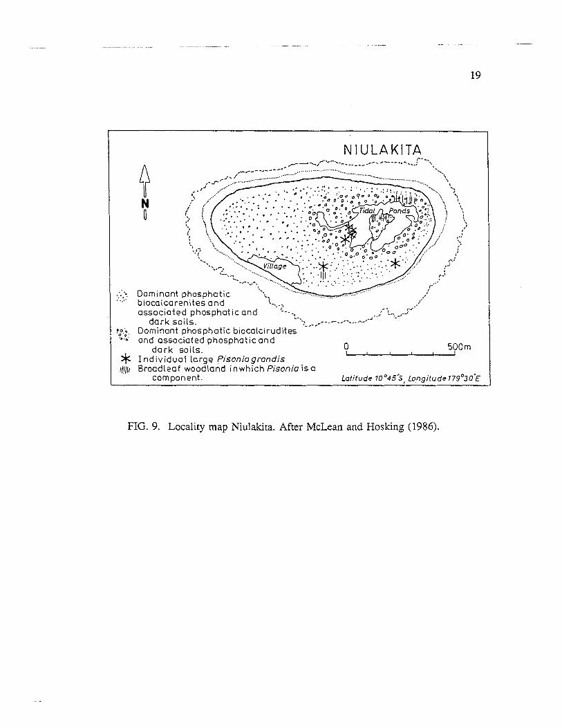
FIG. 9. Locality map Niulakita. After McLean and Hosking (1986).
perimeter about the lagoon. On the eastern, windward side, two narrow, 150 m wide islets form an almost continuous strip of land. Several small islets occupy the northern and southern ends, while only one islet, Fangaua, occurs on the leeward reef. Total land area is about 183 ha.
White (in White and Warin, 1964) failed to locate any trace of phosphate on either Fangaua or Tumiloto (Motuloa) but McLean, Holthus, Hosking, Woodroffe and Hawke (1986~) found a small area of phosphatic blocks and soil in south central Tumiloto in a coconut replant area which they considered had once been covered by Pisonia woodland. This islet consists of two, low, parallel, sandy rubble ridges flanking both the lagoon and ocean shores, and separated by a somewhat swampy, trough-like depression, up to 90 m wide. The deposit is part of the lagoonside terrace which rises 1.5 m above the adjacent beach. Blocks of phosphatized calcarenite, commonly 5-30 cm across, are littered over the surface in a matrix of loose sandy soil, smaller phosphatized clasts and roots and extend to a depth of 12 cm. Below this level the sand is stained with phosphate for only a short distance. Surface blocks can be found scattered for over a 100 m across the islet continuing into the central depression but becoming less common towards the ocean. Total area over which they occur is about 0.9 ha.
It was of Nukulaelae that Graeffe (1876, p.1161) made specific reference to "die Excremente der Seevogel, die sich gern auf solchen kleinen Banken aushalten, ebenfalls humus bildend".
NIULAKITA
Niulakita is a small, roughly oval (900 x 500 m) reef island, broadening slightly to the south, and with its long axis oriented east-west (Fig. 9). The land area of 40 ha occupies about two thirds of the possible reef top. The narrowness of the surrouncling reef and the exposure of the coast to wave action, results in the island's beaches reaching higher levels than those of other islands of the archipelago, while the usual distinction between windward and leeward side is less apparent (McLean and Hoslung, 1986).
Niulakita is the most southerly island of Tuvalu. It enjoys the.highest rainfall of the group and has long been renowned for the relative richness of its soil and the range of crops whch can be grown. Phosphatic soils dominate on this island, covering 70% of the land area. Along with the associated phosphatized limestone crust, they were exploited in the late nineteenth century and small quantities shipped to Auckland, New Zealand, between 1889 and 1902 (Nia, 1983). No records of this activity are known and the extent to which soil profiles and land surface were disturbed is difficult to assess. Subsequent reports on the extent of the remaining phosphate are conflicting (Archives of High Commissioner of the Western Pacific e.g. Schulze, 1903; British Phosphate Commission unpublished reports; White and Warin, 1964; Flynn and Makin, 1976; Nia, 1983; McLean and Hosking, 1986). While the deposit may be insignificant when comp'ared with those
at Nauru and Ocean Island, the surveys of Flynn and Makin (1976) and Mclean and Hosking (1986) indicate that the rocks and associated soils are still the most extensive, sub-aerial phosphate deposit in Tuvalu, exceeding 500,000 tons but of unknown grade.
A beach berm ridge swale complex surrounds the island. The central eastern half of the island consists of a depressed area which contains a number of irregular ponds which fill and drain in response to tidal movement. Their margins are steep scarps, 1-2 m high, developed in strongly phosphatized biocalcirudite. The western and southern half of the island is a more or less featureless flat, bordered by the coastal ridge.
McLean and Hosking (1986) distinguish two main variants of phosphatic and dark soils: those which are predominantly sandy and those dominated by gravel. within each textural variety they were unable to map separate areas of phosphatic and dark soils. Compared with soils developed elsewhere in Tuvalu, including the remainder of Niulakita, these soils are darker in color, have a deeper top soil and show a more distinct break between soil and parent material. Top soils have a high (-30%) organic content and are invariably non-calcareous and even mildly acidic. Those formed above calcarenite substrate possess a crumb and nut structure seen elsewhere in Tuvalu only on Vaitupu where it is not as extensively developed.
Sandy phosphatic soils are typically 40-50 cm thick and commonly have a surface cover of fresh or partly decomposed organic matter mixed with 2-5 cm diameter phosphatic limestone blocks. Beneath, the profile comprises 2-5 cm dark brown loamy top soil over a reddish brown loamy sand speckled with white bioclastic sand grains and containing partially consolidated 2-5 cm diameter blocks. Frequently a hardpan of indurated phosphatic limestone up to 20 cm thick occurs a few centimeters beneath the surface and is also exposed over considerable areas of the island where the top soil has been removed. Whether this second horizon has been indurated or not, there is an abrupt break to a lower 15-20 cm zone of lighter, brownish grey, stained sand. The intensity of the staining declines with depth until unaltered parent carbonate sands are reached.
Phosphatic gravelly soils are similar. Apart from textural differences, the horizon differentiation is poorer and the hardpan thicker, often reaching up to 2 m about the eastern ponds. Irrespective of type of vegetation cover, the ground surface is littered with a dense cover of fresh and decomposing organic matter mixed with algal coated rubble and phosphatized carbonate blocks. Top soil is a dark brown or reddish brown black gravelly loam, commonly 15-30 cm thick and showing both phosphatized and unmodified bioclasts set in a silty matrix. Beneath this topsoil, the gravel framework may be quite open with only dark staining around individual clasts, or voids can be infilled by either stained sand or organic mud. In places where the latter is present, the entire subsurface layer is f m l y cemented together and only broken into blocks by penetration of tree roots.
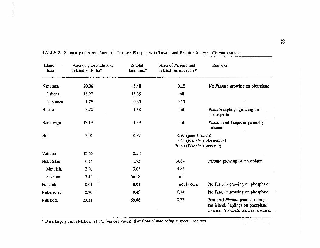
TABLE 2. Summary of Areal Extent of Crustose Phosphates in Tuvalu and Relationship with Pisonia grandis
Island Area of phosphate and % total Area of Pisonia and Remarks Islet related soils, ha* land area* related broadleaf ha*
Nanumea 20.06
Lakena 18.27
Nanumea 1.79
Niutao 3.72
Nanumaga
Nui
Vaitupu
Nukufe tau
Motulala
Sakalua
Funafuti
Nukulaelae
Nuilakita
0.10 No Pisonia growing on phosphate
nil
0.10
nil Pisonia saplings growing on phosphate
nil Pisonia and Thepesia generally absent
4.97 (pure Pisonia) 5.45 (Pisonia + Hernandia)
20.80 (Pisonia + coconut)
14.84 Pisonia growing on phosphate
4.85
nil
not known No Pisonia growing on phosphate
0.74 No Pisonia growing on phosphate
0.27 Scattered Pisonia abound through- out island. Saplings on phosphate common. H e d a common associate.
* Data largely from McLean et al., (various dates), that from Niutao being suspect - see text.

It should be noted that McLean and Hosking (1986) found that Pisonia woodland per se, covers only 0.27 ha or 0.63% of the island. However, medium sized Pisonia are dotted throughout the coconut woodland of all the central (phosphatized) area and small saplings of Pisonia are widespread in the understory vegetation. The main areas of Pisonia woodlandoccur around the central pools, east of the village. Hernandia may be mixed into the canopy. The ground is either bare or covered with Asplenium and Phymarodes.
GEOBOTANY
A strong geobotanical relationship is alleged to exist between low island phosphates and Pisonia grandis (e.g. Shaw, 1952; Fosberg, 1957).
Common elements in the apparent association of Pisonia, certain bird species and the occurrence of low island phosphates are:
a strong preference for some birds to use the trees as roosts and nesting sites (e.g. Memll in Christopherson, 1927).
dispersal of the glutinous seeds by birds when these become embedded in feathers (e.g. St John, 1951).
accumulation of raw humus beneath Pisonia groves - an unusual occurrence on tropical low islands (e.g. Fosberg, 1957).
development of black-brown, organic-rich soil containing abundant calcium and water soluble phosphate and low carbonate, with a pH 5.0-6.5 (e.g. Mayor, 1924; Lipman and Taylor, 1924; Christopherson, 1927).
a phosphatized hard pan beneath the soil, commonly 10-20 cm thick but up to 0.5 m with low or even nil carbonate - a true phosphatite (e.g. Christopherson, 1927).
a calcareous substrate.
AIthough a Pisonia-phosphate association may have existed in Tuvalu in the past, man-induced changes make it impossible to recognize such a relationship today throughout most of the archipelago, or indeed, to ascertain whether it was present in the virgin environment (Table 2). The species does not occur today at phosphate localities on five islands. On the remaining four islands, established Pisonia stands are found at four phosphate localities with saplings sprouting on parts of deposits. However, the tree grows luxuriantly where phosphates have not been identified, and new saplings have been observed sprouting on phosphate-free substrate (e.g., Nui). Only in some restricted m a s of Niulakita are several of the elements enumerated above found associated. Consequently, the presence or absence 'of Pisonia in the present day should not be taken as a geobotanical indicator as, for example, is implied by Woodroffe (1981).
The same man-wrought changes in the Tuvaluan environment also make ineffectual attempts to appraise the relevance of models proposed by various workers, to explain Pisonia-phosphate relationships identified in other island groups.
For example, Shaw (1952) followed up observations of Christopherson (1927) in suggesting that Pisonia grandis required an abundant supply of phosphate, in association with limestone, at least for its germination and early development. He saw such edaphic conditions as being best provided in the zone immediately underlying bird colonies on reef islands where seeds carried by the birds could germinate. He further suggested that where the phosphate/guano supply becomes depleted, that Pisonia would gradually disappear.
Contrariwise, Fosberg (1957) suggested that Pisonia could provide the necessary ingredients for phosphatization of island rock. He drew attention to the humus build up and the acid nature of the underlying soil. These factors he interpreted as providing an environment to render soluble any phosphate in excreta of birds nesting in the trees. The resulting solution would be washed down through the humus by rain and the phosphates precipitated on reaching the alkaline limestone below, consequentially forming the typical hardpan. In such a model crustose phosphate would be an indicator of 'former Pisonia forests and an accompanying bird population.
Both models are plausible but difficult to appraise in the absence of critical data enabling cause and effect to be adjudged. Further, not only is a direct link between phosphate deposits and Pisonia lacking in Tuvalu today, but so is hard evidence for the involvement of birds (Rodgers, 1989a). The contribution of birds in supplying the phosphorous of the deposits is tacitly assumed by most writers yet, while they may well have been primary donors in Tuvalu's past, no present or former bird colony has been identified with any known phosphate deposit. No avian remains have been identified from any deposit. No phosphatization has been found occurring under any of the existing bird colonies in the group.
It may also be noted that when it is present on Tuvaluan phosphatic soils, Pisonia is but one element of a floral association which typically includes Hernandia and/or Asplenium as on Nui, Nanumea, Vaitupu, and Niulakita. Polypodium, Ochrosia and various elements of the Barringtonia formation, of which Pisonia is one component, are also commonly present.
DISCUSSION
Insufficient detailed field studies have been conducted for a complete picture of the relationship of the phosphate deposits within the geology of the islands of Tuvalu to have emerged but some general observations can be made.
Phosphatized limestones and associated soils occur on each of the nine islands of Tuvalu. They are a normal aspect of low island geology and are products of a process which has phosphatized calcareous substrate, cutting across pre-existing sedimentary, pedological and biological structures. The seemingly differing descriptions of the petrography of individual deposits represent no more than different sections of the varied, phosphatized atoll sediments seen by the different workers at the times of their differing visits, e.g. Te Namo (Vaitupu): White and Warin (1964) vs Mclean et al. (1987); Te Kolokolo(Nui): White and Warin (1964) vs Mclean er al. (1986b).
While size of the different deposits varies widely, phosphatization has been more extensive than surface exposures indicate. Excavations show subsurface deposits exist (e.g. Funafuti) whilst resurveys regularly turn up previously overlooked occurrences e.g. Nukufetau and Funafuti.
The precise relationship of cemented phosphate limestone, unconsolidated phosphatized sands and gravels, and phosphatic soil in Tuvalu is not fully understood and any distinction between phosphatic soil, sediment and rock may, to a great extent, be arbitrary as shown by the numerous soil profiles derived by McLean et al., (various dates), representative examples being published in Rodgers (1989a). Rather than phosphatic soil being derived invariably by degradation of pre-existing phosphate rock, a consolidated horizon of phosphatic limestone rock, frequently occurs within the phosphatic soil profile with unconsolidated layers above and below. This consolidated hardpan may have formed by phosphatization of calcareous submate, or of a pre-existing calcareous regosol or of an earlier formed unconsolidated phosphatic horizon. Frequently the hardpan is broken up and distributed throughout a later formed soil profile while indurated phosphate surface crust can be shown to be former soil hardpan, now exposed following erosion of an overlying unconsolidated horizon (e.g. at Niulakita: McLean and Hosking, 1986).
Surface outcrops are being physically eroded by the normal processes of mechanical weathering such as abrasion by wind and waves. Disruption of the deposits occurs through root wedging (e.g. Nui, Funafuti, Nukulaelae, Niulakita), and the activities of man (e.g. Funafuti, Vaitupu) and domesticated animals, particularly pigs (e.g Amatuku). Wave and wind activity during Bopical storms has heavily modified some coastal outcrops in historic times (e.g. Nukufetau, Funafuti).
Where phosphate rocls/hardpan is exposed, it controls the local geomorphology insofar as it is more resistant to weathering than unphosphatized calcareous substrate. Phosphatized rocks form low lagoonal cliffs (e.g. Amatuku: Sollas, 1904), phosbergs in the intertidal zone (e.g. Amatuku: Rodgers 1989b), extensive surface crusts (e.g. Sakalua: White and Warin, 1964), or resistant boulders protruding from surfaces (e.g. Fongafale).

Chemical weathering is slight, with hydroxyapatite having a reduced solubility under the high pH conditions of natural atoll waters. Induration of inland outcrops is occurring in a manner similar to that described in the weathering of typical calcareous phosphorites (Altschuler, Clarke and Young, 1958). Differential dissolution of carbonate yields a resistant, fine-grained phosphate residue which gets swept into previously unfilled pores (cf. Niulakita).
No evidence has been found of present day phosphatization in Tuvalu, possibly because it has not been looked for, but much subsurface hardpan phosphate appears extremely fresh, lacking the powdery, degraded, residual appearance of surface outcrops. Evidence elucidated by Radke (1986) from Sakula (Nukufetau) indicates that the phosphatization process has been either C O ~ M U O U S ~ ~ or at least episodically active throughout the last 4000 years i.e. for at least as long as the islands have existed more or less as they are today.
Conventional wisdom regards low island phosphatic crust as formed within the vadose zone (Stoddard and Scoffin, 1983) with the relatively sharp junction at the base of most hardpans indicating an abrupt planar limit on the deposition of phosphate. The width and depth of hardpan at Tuvalu perhaps reflects fluctuation of the vadose environment within the substrate. The height of the vadose zone varies with the coarseness of the substrate sediment and it can be noted that the thickness of the hardpan often varies with coarseness of the cemented clasts (e.g. Niulakita.)
The mineralogy of the deposits, the source of the phosphate, and the mechanism whereby it accumulates in the vadose zone are discussed elsewhere (e.g. Rodgers, 1989a,b). Suffice to say here that present deposits are regarded as exhumed accumulations of carbonate hydroxyapatite, formed in vadose zones related to former higher sea levels. Phosphorous is believed to have been surface derived from both terrestrial and marine organisms including, birds, plants, and degradation of the biominerals of the calcareous substrate. Transport from the surface to the vadose zone, through the high pH soils of the islands, was probably via humic complexes (cf. Fosberg, 1957). If humic phosphate continues to arrive in or at the water table, and with discharge of soluble phosphorous to the sea being limited (e.g. Elpatievsky, 1985), any soluble phosphate must be either recycled out or removed from solution if eutrophication of the atoll's fresh water lens is not to occur (cf. Brown, 1973). Precipitation of phosphorous as insoluble apatite in the vadose zone would effectively remove the element from further immediate participation in the atoll's biogeochemical cycle, and thereby prevent eutrophication of the atoll water tables as progressive amounts of phosphorous are cycled through them.

27
ACKNOWLEDGMENTS
The major unpublished sources that were consulted are held in the offices of CCOPISOPAC, United Nations Development Program, Suva, The National Library and Archives of Tuvalu, and the Department of Geography, University of Auckland, New Zealand. Thanks are owed to Professor Roger McLean, Drs Peter Hosking and Colin Woodroffe, and to various staff of CCOPISOPAC who freely provided documents, maps and infomation, and gave permission to use their infomation. The iate Sam Rawlins of Funafuti, Tuvalu, introduced the author to the phosphates of Amatuku as well as obtaining and supplying samples. Fred Pullen and Teu Manuella from Ministry of Commerce and Natural Resources, Tuvalu gave invaluable support. Professor Camck Chambers of Royal Botanic Gardens, Sydney, made suggestions concerning the present status of our knowledge of Pisonia grandis with Dr Fosberg of the Smithsonian Institution providing advice on the same subject, not all of which was taken. Dr Alex Ritchie and Carol Cantrell of the Ausmlian Museum furnished quarters conducive to study. Education and Leave, and Research Committees of the University of Auckland supplied funds enabling this work to be undertaken.
REFERENCES
Aharon, P. and Veeh, H.H., 1984. Isotope studies of insular phosphates explain atoll phosphatization. Nature 309:614-617.
Altschuler, Z.C., 1973. The weathering of phosphate deposits - geochemical and environmental aspects. In: Griffith, E.J., Beeton, A., Spencer, J.M. and Mitchell, D.T., eds, Environmental phosphorous handbook. John Wiley, New York. pp.33-96.
Altschuler, Z.C., Clarke, R.S. and Young, E.J., 1958. Geochemistry of uranium in apatite and phosphorite. U.S. Geological Survey Professional Paper 314D:45-90.
American Geological Institute, 1974, Glossary of geology and related sciences. 2nd ed. Washington. 325p.
Becke, L., 1906. Notes from my south sea log. Werner Laurie, London,
Brown, W.E., 1973 Solubilities of phosphates and other sparingly soluble compounds. In: Griffith, E.J., Beeton, A., Spencer, J.M. and Mitchell, D.T., eds, Environmental phosphorous handbook. John Wiley, New York. p.203-240.
Christopherson, E., 1927. The vegetation of the Pacific equatorial islands. Bernice P. Bishop Museum Bulletin 44:l-79.
Cochet, A.M., 1900. Les Tles Ellice. Annales de Notre-Dame du Sacre-Couer, July 1900:338-392.
Cook, P.J., 1975. Prospects for finding offshore phosphate deposits in the southwest Pacific (Project CCOP-l/REG-11). United Nations Economic and Social Commission for Asia and the Pacijic, Committee for Co-ordination of Joint Prospecting for Mineral Resources in the South Pacific Offshore Areas, Proceedings 3rd session CCOPISOPAC, Apia, 2-10 September 1974:75-85.
Cooksey, T., 1896. Rock specimens from Funafuti. Australian Museum Memoir 3:73-78.
Cullen, D.J., 1986. Submarine phosphate sediments of the SW Pacific. In: Cronan, D.S., ed., Sedimentation and mineral deposits in the southwestern Pacific Ocean. Academic Press, London. pp.183-235.
Cullis, C.G., 1904. Mineralogical changes observed in cores of Funafuti borings. In: The atoll of Funafiti: Borings into a coral reef and the results: Report, Coral Reef Boring Committee, Royal Society of London. Harrison and Sons. Section XIV:392-420.
David, T.W.E. and Sweet, G., 1904. The geology of Funafuti. In: The atoll of Funafiti: Bon'ngs into a coral reef and the results: Report, Coral Reef Boring Committee, Royal Society of London. Harrison and Sons. Section V:61-124.
Duncan, R.A., 1985. Radiometric ages from volcanic rocks along the New Hebrides- Samoa lineament. In: Brocher, T.M., ed., Investigations of the northern Melanesian borderland: Circum-Pacijic Council for Energy and Mineral Resources Earth Science Series 3:67-76
Elpatievsky, P.V., 1985. Soils of reefogenous islands as the phosphorous pool. Proceedings, Fifrh International Coral Reef Congress, Tahiti 2:119.
Flym, G. and Makin, J., 1976. A survey of the prospects for agricultural and industrial development in Tuvalu. Mimeographed report. Scientific Units, United Kingdom Ministry of Overseas Development, London. 180p.
Fosberg, F.R., 1957. Description and occurrence of atoll phosphate rock in Micronesia. American Journal of Science 255584-592.
Gaskell, T.F., Hill, M.N. and Swallow, J.C., 1958. Seismic measurements made by HMS Challenger in the Atlantic, Pacific and Indian Oceans and in the Mediterranean Sea 1950- 1953. Philosophical Transactions of the Royal Society of London A251:23-83.
Graeffe, E., 1867. Reisen nach verschiedenen Inseln der Siidsee. Das Ausland a m dem Gebiete der Natur-, Erd-, und Volkerkunde 40: 1 159- 1 164, 1 184- 1 19 1.
Hedley, C., 1896. General account of the atoll of Funafuti. Australian Museum Memoir 3: 1-72.
Hutchinson, G.E., 1950. Surveys of existing knowledge of biogeochemistry 3: The biogeochemistry of vertebrate excretion. Bulletin of the American Museum of Natural History 96: 1-554.
Judd, J.W., 1904. Chemical examination of the materials from Funafuti. In: The atoll of Funafiti: Borings into a coral reef and the results: Report, Coral Reef Boring Committee, Royal Society of London. Harrison and Sons. Section X:167-185.
Lee, A.I.N., ed., 1980. Fertilizer mineral occurrences in the Asia-Pacific region. East- West Resource Systems Institute, Honolulu. 156p.
Lifuka, N., 1978. Logs in the current of the sea. Australian National University Press, Canberra. 11%.
Lipman, C.B. and Taylor, J.K., 1924. Bacteriological studies on Rose Islet soils: Carnegie Institution, Marine Biology Papers 19:201-208.
Luomala, K., 1951. Logbook of a voyage to the middle of the earth. Pacific Discovery 4:4-13.
McConnell, D., 1950. The petrography of rock phosphates. Journal of Geology 58: 16-23.
McLean, R.F. and Hosking, P.L., 1986. Niulakita. Tuvalu Land Resource Survey Island Report, Department of Geography, University of Auckland, 9, 55p, A20p, 4 maps.
McLean, R.F., Holthus, P.F., Hosking, P.L. and Woodroffe, C.D., 1985. Nanumaga. Tuvalu Land Resource Survey Island Report, Department of Geography, University of Auckland, 2, 72p, A4%, 4 maps.
1986a. Nanumea. Tuvalu Land Resource Survey Island Report, Department of Geography, University of Auckland, 1, 83p, A65p, 10 maps.
1986b. Nukufetau. Tuvalu Land Resource Survey Island Report, Department of Geography, University of Auckland, 6, 81p, A28p, 20 maps.
McLean, R.F., Holthus, P.F., Hosking, P.L., Woodroffe, C.D. and Hawke, D.V., 1986a. Niutao. Tuvalu Land Resource Survey Island Report, Department of Geography, University of Auckland, 3, 66p., A18p., 4 maps.
1986b. Nui. Tuvalu Land Resource Survey Island Report, Department of Geography, University of Auckland, 4, 82p, A44p, 8 maps.
1986c. Nukulaelae. Tuvalu Land Resource Survey Island Report, Department of Geography, University of Auckland, 8, 86p., A44p., 16 maps.
Mayor, A.G., 1924. Rose Atoll, American Samoa. Carnegie Inst. Marine Biology Papers 19:73-9 1.
Morgan, W.J., 1972. Deep mantle convection plumes and plate motions. American Association of Petroleum Geologists, Bulletin 52:203-2 13.
Nia, Nalu, 1983. Niutao. In: Laracy, H., ed., Tuvalu, a history. 'Institute of Pacific Studies, University of the South Pacific, Suva. p.58-65
Radke, B.M., 1985. Seismic and bathymetric profiling of Nukufetau lagoon, Tuvalu, for evaluation of phosphate potential, Tuvalu, February-March 1985. Committee for Co- ordination of Joint Prospecting for Mineral Resources in South Pacific Offshore Areas (CCOPISOPAC) Cruise Report 108, unpaged.
1986. Bathymetric and seismic features of Nukufetau lagoon, Tuvalu: An appraisal of submarine phosphate potential. Committee for Co-ordination of Joint Prospecting for Mineral Resources in South Pacific Offshore Areas (CCOPISOPAC) Technical Report 57 (of PEfI".91Task I), 28p.
Rodgers, K.A., 1987. The mineralogy of a phosphatic horizon, Amatuku islet, Funafuti atoll, Tuvalu. South Pacific Journal of Natural Science 9:49-56.
Rodgers, K.A. 1989a Phosphatic limestones from Tuvalu (Ellice Islands). Economic Geology 842252-2226.
Rodgers, K.A., 1989b. Dahllite and whitlockite from Amatuku, Tuvalu. Mineralogical Magazine 53: 123-125.
Rodgers, K.A. and Cantrell, C., 1987. Tuvalu's weather and climate: an annotated bibliography. South Pacific Journal of Natural Science 9: 11 1-142.
Sahng-Yup, Kim, 1981. Advisory report of the reconnaissance geology and mineral resources of Funafuti Atoll, Tuvalu. Unpublished. RMRDC Report, Economic and Social Commission for Asia and the Pacific no.130, 26p.
Schulze, O., 1903, Unpublished report. Archives, High Commissioner, Western Pacific, Funafuti.
Scolari, G. and Lille, R., 1973. Nomenclature et classification des roches ~Cdimentaires (Roches detritiques temghes et roches carbonatkes). Bulletin, BRGM., 2, section IV, no. 2:57- 132.
Shaw, H.K., 1952. On the distribution of Pisonia grandis R. Br. (Nyctaginaceae), with special reference to Malaysia. Kew Bulletin no.1, 1952: 87-97.
Slansky, M., 1980. GCologie des phosphate ~Cdirnentaires. Mimoire, BRGM., 114:l-92.
Sollas, W.J., 1904. Narrative of the expedition in 1896. In: The atoll of Funafuti: Borings into a coral reef and the results: Report, Coral Reef Boring Committee, Royal Society of London. Harrison and Sons. Section 1:l-28.
St John, H., 1951. The distribution of Pisonia grandis (Nyctaginaceae). Webbia 8:225- 228.
Stoddard, D.R. and Scoffin, T.P., 1983. Phosphate rock on coral reef islands. In: Goudie, A.S. and Pye. K., eds, Chemical sediments and geomophology. Academic Press, London. p.369-400.
Tracey, J.I., 1980. Quaternary episodes of insular phosphatization in the central Pacific. In: Sheldon, R.P. and Burnett, W.C., eds, Fertilizer mineral potential in Asia and the Pacific. Proceedings, Fertilizer Raw Materials Resources Workshop, August 20-24 1979, Honolulu (East-West Resource Systems Institute, Honolulu), p.247-261.
Tudor, J., 1966. Many a green isle. Pacific PublicationsMnerva, Auckland, 2 5 6 ~ .
Warin, O.N., 1968. Deposits of phosphate rocks in Oceania. In: Proceedings, Seminar of Mineral Raw Materials for the Fertilizer Industry in Asia and the Far East: ECAFE Mineral Resources Development Series (United Nations, New York) 32: 125- 132
Warner, J.B. and Rossfelder, A., 1978. Final report CEPAC-1, reconnaissance cruise, central Pacific. Unpublished report, Geomarex, 33p.
White, W.C. and Warin, O.N., 1964. A survey of phosphate deposits in the south-west Pacific and Australian waters. Commonwealth of Australia Bureau of Mineral Resources, Geology and Geophysics, Bulletin 69: 1 - 173.
Woodroffe, C.D., 1985. Vegetation and flora of Nui atoll, Tuvalu. Atoll Research Bulletin 283:l-18.