im rahmen des der paris lodron-universität salzburg zum
TRANSCRIPT

Master Thesis im Rahmen des
Universitätslehrganges „Geographical Information Science & Systems“ (UNIGIS MSc) am Zentrum für GeoInformatik (Z_GIS)
der Paris Lodron-Universität Salzburg
zum Thema
„GIS based, geo-targeted emergency notification systems“
For mobile devices in the United States
vorgelegt von
Andreas Wohlsperger U1252, UNIGIS MSc Jahrgang 2006
Zur Erlangung des Grades „Master of Science (Geographical Information Science & Systems) – MSc(GIS)”
Gutachter:
Ao. Univ. Prof. Dr. Josef Strobl
Washington, D.C., 17. Juni 2008

Statement of Originality
I certify that this thesis, and the research to which it refers, are the product of my own
work, and that any ideas or quotations from the work of other people, published or
otherwise, are fully acknowledged in accordance with the standard referencing practices of
the discipline.
The work has not been presented previously for any degree, nor is it at present under
consideration by any other degree awarding body.
ii
______________________ __ June, 17, 2008
Signature Date

iii
Abstract
Political pressure for predicting, preparing, and responding to natural and manmade
disasters is growing in the United States. In the wake of Hurricane Katrina, terrorist attacks,
wild fires, and other incidents, more and more emergency management agencies are relying
on automated telephone notification systems to inform the affected population of the
imminent danger. These systems, known as “Reverse 911” are especially helpful for
disaster events that have little to no warning time. Chemical spills, industrial plant
explosions, and terrorist attacks cannot be predicted, so the ability to send out immediate
alerts to the affected population is very important. Most all of these automated calling
systems in the US rely on the emergency 911 database, which is a listing of addresses or
coordinates associated with land line phone connections. As more people rely exclusively
on mobile communication devices, which are generally not included in the Reverse 911
database, a growing portion of the population is excluded from this alert system.
The problem discussed in this thesis is how people can be notified that are not included in
the 911 database, due to their reliance on mobile devices and their own mobility. The
possibility of an emergency notification system based on mobile services is evaluated,
possible concepts of such systems are proposed, and potential implementation is discussed.
The proposed systems use GIS data in the form of disaster extent information generated by
GIS applications and text-based alert messages are being transmitted to mobile devices via
geo-targeted push services.

iv
Table of Contents
Statement of Originality ...................................................................................................... ii
Abstract ................................................................................................................................. iii
List of Tables ........................................................................................................................ vi
Glossary & Abbreviations .................................................................................................... vii
1.0 Introduction .......................................................................................................... 1
1.1 Statement of Problem ................................................................................... 1 1.2 Motivation ....................................................................................................... 2 1.3 Methodology ................................................................................................... 2 1.4 Expected Results ............................................................................................ 3 1.5 Items Excluded From Research .................................................................. 3 1.6 Intended Audience ........................................................................................ 4 1.7 Structure of Thesis (Flow Chart) ................................................................ 4
2.0 Research ............................................................................................................... 8
2.1 Emergency Notification Research .............................................................. 8 2.1.1 Emergency Notification Systems Employed in the United States ..................... 8 2.1.2 Stakeholders ..................................................................................................... 13 2.1.3 People’s Behavior during Emergency Notification ......................................... 16 2.1.4 Chemical spill event example (USC, 2005) .................................................... 18 2.1.5 Current Regulatory Aspects ............................................................................ 19 2.1.6 FCC 94-102 .................................................................................................... 23
2.2 Technology Research .................................................................................. 26 2.2.1 GIS Applications for Emergency Management .............................................. 26 2.2.2 Communication Technology – Short Message Services ................................ 29 2.2.3 Location Based Services ................................................................................. 31
3.0 Theoretical Solution ........................................................................................... 34
3.1 Emergency Notification Scenario and Timeline .................................... 34 3.1.1 Emergency Event ............................................................................................ 34 3.1.2 GIS Prediction Models ................................................................................... 35 3.1.3 EAS – Established Emergency Alert System .................................................. 39 3.1.4 Mobile Device Notification in addition to EAS ............................................. 41
3.2 Description of System ................................................................................. 41 3.2.1 Description of Passive System ........................................................................ 42 3.2.2 Desired Outcome of Passive System .............................................................. 43 3.2.3 Description of Active System ......................................................................... 44 3.2.4 Desired Outcome of Active System ................................................................ 48
3.3 Graphical Depiction of EAS Event Timeline ......................................... 50
4.0 System Implementation Discussion ................................................................... 53

v
4.1 Items to consider for Implementation ..................................................... 53 4.1.1 Scale of Implementation ................................................................................. 53 4.1.2 Open Source Infrastructure ............................................................................. 54
4.2 Component Discussion for the Active System based on LBS ............ 57 4.2.1 GIS Emergency Data ....................................................................................... 57 4.2.2 Mobile Devices ............................................................................................... 59 4.2.3 Service Provider and Gateway Services ......................................................... 60 4.2.4 Content and Data Provider .............................................................................. 62
4.3 Implementation Milestone Graphical Overview ................................... 64
5.0 Results of Research ............................................................................................ 65
6.0 Analysis of Research Results ............................................................................. 67
7.0 Conclusion ......................................................................................................... 70
7.1 Summary of Research ................................................................................. 71 7.2 Future Research ........................................................................................... 71 7.3 Personal Statement ...................................................................................... 72
References & Sources ............................................................................................................A

vi
List of Figures
Figure 1 - Overview Flowchart ........................................................................................... 4 Figure 2 - Introduction and Research Flowchart ................................................................ 5 Figure 3 - Implementation Discussion Flowchart ............................................................... 6 Figure 4 - Results and Conclusion Flowchart ..................................................................... 7 Figure 5 - Regulatory Overview of Communications (Text Source: FCC) ...................... 21 Figure 6 - Regulatory Overview of Communications Continued (Text Source: FCC) .... 22 Figure 7 - Hurrevac – Storm Intensity Prediction Application (Source:
http://www.hurrevac.com) .................................................................................... 27 Figure 8 - PlumeRae (Source: REA Systems) .................................................................. 28 Figure 9 - LBS components (source: OpenLS) ................................................................. 32 Figure 10 - NHC monitoring site (Source: NHC) ............................................................. 35 Figure 11 - Hazards Analyst Screen Capture (Hurricane Fran dataset) ............................ 37 Figure 12 - Results of Risk Assessment in Hazards Analyst ............................................ 38 Figure 13 - EAS Alert Message Example (Source Illinois EAS) ..................................... 40 Figure 14 - Passive System Graphic (individual items not shown to scale) .................... 43 Figure 15 - Active System Phase I (individual items not shown to scale)........................ 46 Figure 16 - Active System Phase II (individual items not shown to scale) ...................... 47 Figure 17 - Active System Phase III (individual items not shown to scale) ..................... 48 Figure 18 - EAS Timeline Scenario - Day 7- Day 1 ......................................................... 50 Figure 19 - EAS Timeline Scenario - final 24 hours ........................................................ 51 Figure 20 - EAS Timeline Scenario - post event .............................................................. 52 Figure 21 - FME translation sample ................................................................................. 58 Figure 22 - Implementation Milestones ............................................................................ 64
List of Tables
Table 1 - EAS - Television and Radio ................................................................................ 9 Table 2 - Reverse 911 ....................................................................................................... 10 Table 3 - Loud Speakers ................................................................................................... 11 Table 4 - Sirens ................................................................................................................. 11 Table 5 - Responsible Parties for Emergency Management ............................................. 15 Table 6 - Parties Assisting in Emergency Management ................................................... 16 Table 7 - HA Logistics Report and HA Risk Assessment (Source: Watershed Concepts)39 Table 8 - GML example of a disaster area extent dataset ................................................. 59 Table 9 - Possible Location Request Example (based on OpenLS 9.2.2) ........................ 61 Table 10 - Possible Location Response Example for one return
(based on OpenLS 9.2.2) ....................................... Error! Bookmark not defined. Table 11 - Sample Alert Message based on CAP 1.1 (XML) .......................................... 63

vii
Glossary & Abbreviations
ASCE American Society of Civil Engineers
CAN SPAM Act Controlling the Assault of Non-Solicited Pornography and Marketing Act
CAP Common Alert Protocol. XML based open format protocol developed by Art
Botterell
CDMA Code Division Multiple Access standard
CMS Commercial mobile service
CMAM Commercial Mobile Alert Message
CMAP Commercial Mobile Alert Provider
CMSAAC Commercial Mobile Service Alert Advisory Committee
CVS Comma Separated Value – file type that stores tabular data
CTIA International Association for Wireless Telecommunications Industry
DHS Department of Homeland Security
E-911 Enhance emergency response phone directory database. Phone numbers are spatially enabled and include fixed location information. E-911 is usually associated with a GIS response system and dispatcher.
EAS Emergency Alert System
ESRI Environmental Systems Research Institute
IPAWS FEMAs Integrated Public Alert and Warning System
FCC Federal Communication Commission
FEMA Federal Emergency Management Agency
GIS Geographic Information Systems
GML Geographic Markup Language; XML standard for geographic data
GMS Global System of Mobile communication standard

viii
HA Hazards Analyst
HSMM Hayes, Seay, Mattern, and Mattern
Hurrevac HURRicane EVACuation - Hurricane path prediction software developed by FEMA and the USACE
ISO International Standard Organization
LBS Location Based Services
NHC National Hurricane Center
NOAA National Oceanographic Atmospheric Agency
NHC National Hurricane Center
NWS National Weather Service
OGC Open Geospatial Consortium
PSAP Public Safety Answer Points
SAME NOAA Weather Radio All Hazards Specific Area Message Encoding
SLOSH Model FEMA, USACE, NWS SLOSH (Sea, Lake and Overland Surge from Hurricanes) model
USACE United States Army Core of Engineers
XML Extensible Markup Language
1
1.0 Introduction
1.1 Statement of Problem
The problem that is being investigated in this thesis is the challenge of relaying important
information quickly to people affected by an emergency that presents an imminent threat to
well being or to life itself. Examples of such notifications would be the need for
evacuation, evacuation routes, the need to remain indoors, or shelter-in-place. (Lewes, City
of, 2008)
The current means of emergency notifications in the United States range from television
announcements and radio messages (FCC, 2008; FEMA, 2008) to voice recordings sent to
land-line telephone connections (Reverse 911, 2008; McClure, 2008). For the most part,
the over 258 million mobile devices, such as cellular phones, in the United States (CTIA,
2008) are only included to a limited extent or are not utilized at all. In some areas of the
United States there are wireless phone notification services available. These services send
emergency notification via voice recording similar to a land line phone, if residents
voluntarily register their device for this service for regional alerts. (San Diego, City of,
2007)
These are all proven methods of emergency notification and they are being applied with
success. (FEMA, 2006) However the described telephone notification systems rely on pre-
disaster, static emergency databases that store spatial information which can be used to
query entries for the affected geographic area. In most cases this database is the 911
emergency database, which combines location information (XY coordinate or address
information) with contact information (phone number) and is maintained by local
emergency service providers such as the police and fire departments. (Fincher, 2007;
McClure, 2008) Even though this is the best dataset available for this type of notification,
many people within any given area are excluded from this database or are not reachable via
land line phone for the following reasons.
1) People that are in the affected area due to travel and their device is not registered.
2) People that are inside of a vehicle and don’t have access to a land line phone.

2
3) People that do not have land-line telephone connections and rely solely on mobile
phones. This number increased from 5 percent in 2005 to 14 percent of the US
population in 2007. (CTIA, 2008)
The lack of ability to reach people that are on the move is the core problem discussed in
this research. GIS disaster prediction applications, location based services, and cell
broadcasting are the main center pieces to resolve this problem.
1.2 Motivation
The future of emergency management and alert notification lies in combining the power of
GIS and GPS with modern communication technology that allows for geo-targeted
messaging. GIS applications that predict area extents of disasters, such as Hurrevac or
PlumeRae, are available and are being developed further on the local, State, and Federal
level. (Daratech, 2008; Hurrevac, 2007; Rae Systems 2006) Distribution of the information
created by these applications is an integral part of emergency management. To date these
valuable datasets are underutilized for emergency notification purposes in the realm of
mobile technology. This research should explore the possibility of incorporating mobile
communication technologies with GIS and location information.
1.3 Methodology
The methodology of this thesis builds upon the principles of research, the development of a
conceptual framework, and a discussion of implementation.
The first section describes the background research. The research section is broken up into
two major categories, emergency management aspects and technology aspects. Specific
topics on the emergency management aspects include:
- Actively used notification systems in the U.S.
- Stakeholders of emergency management in the US
- Current US regulatory framework and legal aspects of emergency notification
- People’s behavior upon receipt of emergency notifications

3
Topics on the technology aspects include:
- Current communication technology, specifically wireless communication
- Current GIS application technology
- Current LBS capabilities
- Developments in other countries
The third section describes the design of a conceptual framework of an emergency
notification system utilizing GIS and LBS/cell broadcasting.
The forth section includes an implementation discussion of such a system.
1.4 Expected Results
The result of this work shall be the development of a conceptual framework that describes
the process of transmitting alert messages, based on emergency extent data developed by
GIS applications, to any mobile device within the affected area via geo-targeted message
transmission. The questions this thesis attempts to answer are as follows:
- Is there a need for an emergency notification system that utilizes area specific
notifications to mobile devices based on GIS in the United States?
- Is a system as proposed above possible with current regulations?
- Is the level of technology sufficient within the United States to implement such a
system?
- If not, what are the shortcomings?
- What kind of communication technology should be the premise of this system?
1.5 Items Excluded From Research
Items and areas of research that are of importance to the overall implementation of an
emergency notification system based on mobile technology are mentioned in many sections
of this work, but detailed investigation of all related topics would go beyond the scope of
this work.
Items not researched in full detail include the detailed protocols and functionality of
communication networks within the United States, the detailed psychological human
behavior during emergency situations, and the detailed legal issues of privacy invasion in
the United States. This work should also not be considered a detailed project management
plan for a system implementation but an exploration of the possible implementation of a
new generation emergency notification system.
1.6 Intended Audience
The intended audience of this work is the UNIGIS team of the University of Salzburg, the
emergency management community, fellow students and researchers with interest in
emergency notification systems, location technologies, and GIS application development.
1.7 Structure of Thesis (Flow Chart)
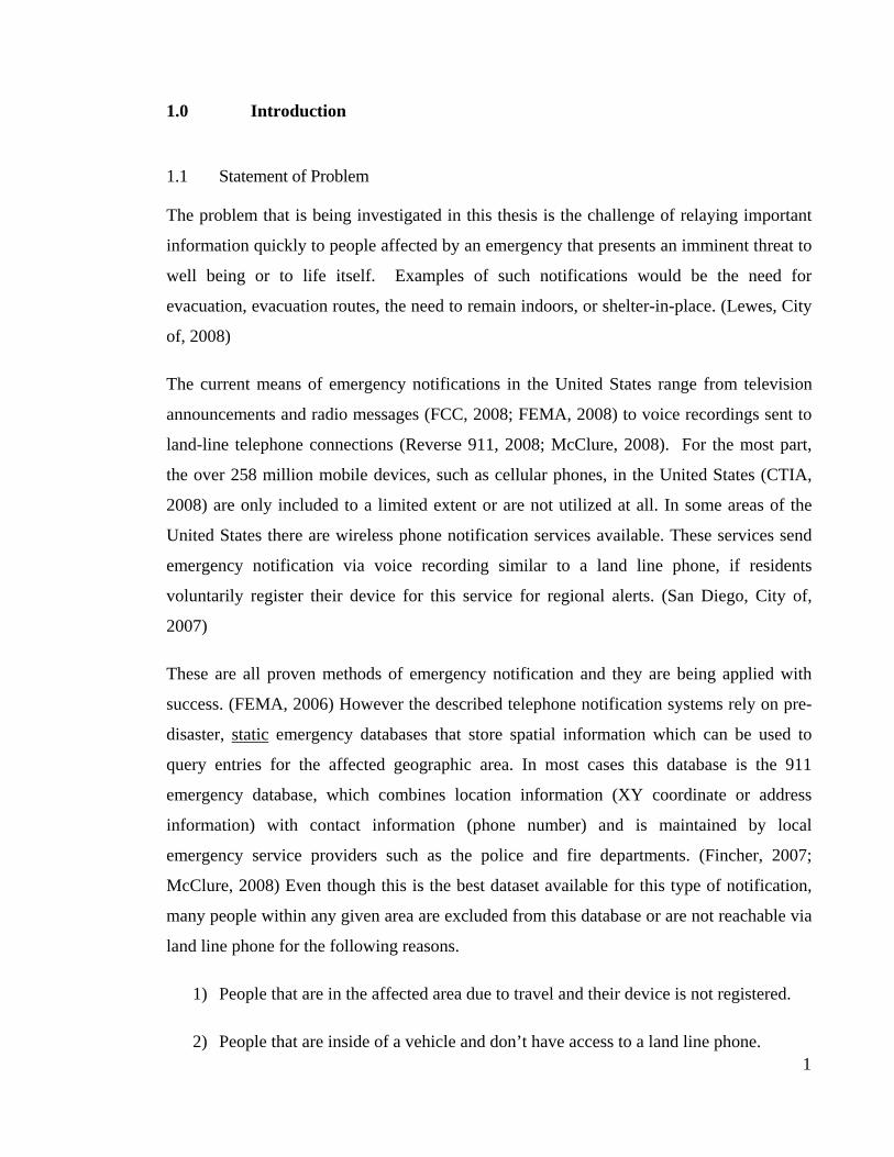
The flow chart depicted as Figure 1, represents the overall structural overview of this work,
whereas Figures 2 through 6 represent more detailed descriptions of the major milestones
1.0 through 7.0 that are displayed in Figure 1.
Figure 1 - Overview Flowchart
4

Section 1.0, the “Introduction”, gives an overview of the topic dicussed in this work and is
aimed towards preparing the reader for the main aspects presented in sections 3.0 through
6.0. In Section 2.0, the research section, several aspects that are of importance to the topic
are researched and discussed. This section solidifies the need for geo-targeted alert message
transmission to mobile devices and supports the theoretical solution and implementation
discussion that follows in sections 3.0 and 4.0.
Figure 2 - Introduction and Research Flowchart
Section 3.0 entitled “Theoretical Solution” gives a description of an emergency notification
event and how a system as proposed in this work may fit in with current procedures. With
the help of a GIS application example and a detailed representation of an event timeline,
the possible seamless integration of the proposed system should be portrayed. This section
also gives descriptions and desired outcomes of two possible notification systems.
5
Section 4.0 includes the systems implementation discussion (Figure 3) which lists items to
consider for the implementation of the proposed systems and also lists specific necessary
components that need to be developed for implementation. The open source infrastructure

possibilities are explored in detail and possible examples are provided. This discussion is
followed by a graphical representation of the implementation milestones.
Figure 3 - Implementation Discussion Flowchart
Sections 5.0 through 7.0 can be considered the final chapters of this work. These sections
summarize the results of the conducted research and evaluate the possibility of
implementation. Section 7.0 also contains a listing of future research related to this topic
and a personal statement.
6

Figure 4 - Results and Conclusion Flowchart
7

8
2.0 Research
The following seven areas of research, organized in two major categories of emergency
management and technology, contain important information related to the topic discussed
in this work. Emergency management, alert notification, and disaster response are complex
fields of study as they incorporate a wide spectrum of variables. The activities associated
with emergency notification attempt to reduce loss of life and property damage under
adverse conditions. (FEMA, 2007)
In many cases, the human factor is the deciding factor in making a notification system
function with success or failure. Therefore human behavior and reaction to certain events
from the emergency management perspective and from the perspective of the affected
population is of great importance. (Whitehead, 2000; Winerman, 2004) Studying the
complete range of human behavior in emergency situations is beyond the scope of this
work, but it should be noted that it is an important aspect when discussing implementation
of emergency notification systems.
The technological aspects of this research are also crucial as they give valuable insight on
the current status of technology and the feasibility of implementing specific systems at this
time or in the future. The regulatory aspects are also significant in terms of standards, as
well as the possibility of violating privacy laws and other legal aspects. In addition,
interoperability of emergency alert systems is of high importance for a uniform coverage
and collaboration of the many stakeholders involved.
The research section gives an indication of the validity and usefulness of a system as
proposed in this work and is the foundation for the implementation discussion in
section 4.0.
2.1 Emergency Notification Research
2.1.1 Emergency Notification Systems Employed in the United States
In order to research the potential need for an additional alert and emergency notification
system, the current systems employed in the United States need to be identified and
analyzed for their effectiveness and their individual shortcomings. The following four

tables list the current US emergency notification systems that are most commonly utilized
during emergency situations. The tables provide a brief overview of each system but are not
a complete analysis of current emergency notification systems. The overview serves the
purpose of pinpointing areas of potential deficiency in terms of people being reached by the
individual systems.
Notification System 1 (FCC 2007; FEMA 2005; FCC - EAS Summit, 2008)
Current System: EAS – Emergency Alert System for TV and radio
Method: Television and radio network stations in the United States are required by law to have an EAS decoder wired into their system to receive and transmit the emergency alert messages provided by emergency management agencies. Upon notification from emergency management agencies, alerts override the current programming and are broadcasted via television or are announced on network and satellite radio on a local, regional or national level.
Pros: - Network and satellite companies obligated by Federal legislation to provide communication capabilities to the President of the United States in order to issue emergency alerts
- Coding protocols similar to NOAA Weather Radio (NWR) - NOAA message encoding (SAME) widely used and accepted
Cons: - The hearing and/or vision impaired population may not be reachable. - Legislation not in place for a mandatory broadcast of state or local
level emergencies (Currently on voluntary basis only) - Transmitter boxes individually programmed and maintained - People travelling may not be reachable. - People at work may not be reachable. - People that do not own a TV or radio may not be reachable. - Partially relies on word of mouth scenarios, where people notify
others who may have not seen the warning - Late night early morning notification not as effective as few people
watch television from 12 AM to 6 AM - Reduced effectiveness during power outages - Geographic alert area at the county level
Effectiveness: Effective for larger scale emergencies of non immediate nature.
- According to the director of FEMA’s Office of National Security Coordination, EAS reaches 95 percent of the US population; however experts such as Dale Gehman or Ann Arnold panelists at the EAS Summit May 19, 2008, suggest a lower success rate around 70 percent.
- Not as effective for small scale imminent disasters such as wild fires, chemical spills, or industrial fires that have short warning timeframes.
Application: Federal, State, Local level
9
Table 1 - EAS - Television and Radio

10
Notification System 2 (San Diego, 2007; CML Company, 2008; McClure, 2008)
Current System: Reverse 911 Method: Emergency management agencies utilize an automated calling system for
land line telephone connections to notify the public in an affected area via recorded voice messages. The phone numbers of the 911 call database are spatially linked to coordinates and/or addresses. This allows for a spatial query of what numbers to call if a specific area is affected. The most accurate call data is a combination of commercial and the 911 call list as it lists unlisted and unpublished numbers.
Pros: - Very regional specific, alerts can be directed to very specific areas - Effective during power outages - Cellular phone numbers can be added to the call list if users
voluntarily register to be added to the static call list Cons: - Only as good as available data
- Developing and maintaining the call database is expensive - Requires advanced communication network - Does not work if this network is down due to overuse or damage
Effectiveness: According to various sources including communication engineer Nathan McClure, this system seems to be utilized with success. This system has proven itself to be especially effective for disasters such as tornados, wild fires, or chemical spills that have short warning timeframes.
Application: Regional, local
Table 2 - Reverse 911

11
Notification System 3 (Conte, 2007; Sarina, City of, 2003)
Current System: Loud Speakers Method: Emergency management personnel and first responders announce alerts
via loudspeakers from vehicles or strategically placed speakers. Pros: - Ensures everyone within a certain distance to the announcement is
aware, if announcement is heard - Can be directed toward specific individuals - Message can be highly specific in area and direction - Functional during blackouts
Cons: - Notification only reaches a limited number of people - Emergency staff exposed to danger in some cases - Hearing impaired people may not hear the alert.
Effectiveness: - Effective for notification right before, during, or after an event - Effective for highly localized events
Application: Local level, first responders
Table 3 - Loud Speakers
Notification System 4 (BePrepared, 2008; Huntsville, City of, 2007)
Current System: Sirens Method: Sirens are installed at strategic locations throughout an area, to be turned on
during an emergency event. Pros: - Simple concept
- Functional during blackouts Cons: - Cannot be heard everywhere
- Outreach is required to avoid confusion about what to do once the siren is audible
- No detailed information on how to react - Costly to maintain - Non-specific to what type of emergency - Hearing impaired people may not hear the alert
Effectiveness: - Historically has been effective during war times, during the cold war, and for weather alerts
Application: Local level
Table 4 - Sirens

12
When reviewing emergency notification scenarios, it becomes apparent that no single
method can be effective in communicating alerts to everyone that needs to be reached.
Which systems and combination of systems to be used is highly dependent on the type of
event, the timeframe of the event, and the scale of the event.
The interagency, interstate, and Federal efforts of EAS have increased the notification
capability of emergency management organizations. As stated by Reynolds Hoover, the
director of the FEMA Office of National Security Coordination, in 2005 (Sarkar, 2005),
EAS reaches an estimated 95 percent of the population, with the combined alerts on
television and radio. This high percentage is being questioned by several experts of the
emergency notification arena. (FCC, 2008) Also, in short notice disaster events such as
chemical spills, industrial fires, or terrorist attacks, television and radio announcement
alone often are not enough, as demonstrated by the analysis of the successful application of
the Reverse 911 method in Graniteville, SC, referred to in detail in subsection 2.1.3. (USC,
2005) Another severe shortcoming of a system partially relying of television is that its
effectiveness is highly reduced during power outages. The American Society of Civil
Engineers and other sources state that the power grid of the United States is severely
threatened by natural disasters and terrorist attacks due to the outdated infrastructure and
lack of investment. Severe and prolonged power outages are therefore foreseeable during
future disaster events. (ASCE, 2005; Wald, 2007; Kaplan, 2007)
To overcome the current shortcomings of EAS, FEMA is actively working on expanding
the notification capabilities of emergency management agencies and started testing the
official incorporation of Reverse 911 and other notification methods into EAS in 2005.
(Sarkar, 2005; FEMA, 2005)
Reverse 911 notification efforts have been highly effective on smaller scale and regional
events such as wild fires, as reported by Scott Fincher in his article “Emergency phone
notification helps wildfire preparedness” in Wildfire Magazine. (Fincher, 2007) Several
large cities, including San Diego, CA, and counties throughout the US have taken the
initiative and implemented such systems on a local or regional level. (San Diego, 2007;
Reverse 911, 2008) The two backbones of such a system are the 911 call database and an
enhanced communications network. Communication networks utilized for such a

13
notification system need to be capable of sending out a vast number of messages within
short timeframes, without overwhelming the system. (Fincher, 2007)
The inclusion of Reverse 911 into EAS will enhance the notification capability of the
system; however further research suggests that although mobile devices are to be included
in this expansion of EAS, the tests conducted in 2005 did not include geo-targeted
messaging. Cell phone notification took place but through registering the mobile device to
a location, similar to many university campus alert systems. (Sarkar, 2005, UVA, 2008)
In 2006 IPAWS, FEMAs Integrated Public Alert and Warning System program was created
in the response to Executive Order 13407:
“It is the policy of the United States to have an effective,
reliable, integrated, flexible, and comprehensive system to
alert and warn the American people....and to ensure under
all conditions the President can communicate with the
American people.”
(Bush, 2006)
The FCC and FEMA are currently developing technical standards and protocols to enable
mobile service providers to transmit emergency alerts under the WARN Act (Oct. 13,
2006). (FCC, 2007) The Public Safety and Homeland Security Bureau (PSHSB) is
spearheading this effort, and is supported by the Commercial Mobile Service Alert
Advisory Committee (CMSAAC). (FCC, 2006)
The system proposed in this work, would enhance the notification capability of the current
system and increase the precision and effectiveness of the overall notification effort by
focusing on geo-targeted notification of mobile devices. EAS is lacking this ability. FEMA
and the FCC are to provide a framework, regulation, and standards for the implementation
of such a system.
2.1.2 Stakeholders
In the United States, emergency management is considered the responsibility of the
government. (DHS, 2008) Taxpayers expect the governing body to allocate appropriate
resources and expertise to ensure the safety of the people, assist the population, and to

14
protect property before, during, and after emergency events, whether they are natural or
man-made. (FEMA, 2007)
Individual State governments are responsible for emergency management within their
jurisdiction. Federal funds and assistance from the Department of Homeland Security
become available to the States only for presidentially declared disaster events. (FEMA,
2007) However, Federal agencies such as FEMA (since 2003 part of DHS) and others, such
as the National Weather Service, NOAA, and the U.S. Army Core of Engineers, contribute
to developing technology, providing guidance, assisting with coordination, and developing
legislation on a national level that support the State’s ability to prepare and respond to
disaster events and mitigate risks. (Hurrevac, 2007; FEMA, 2007)
The Robert T. Stafford Disaster Relief and Emergency Assistance Act of 1974 defines an
emergency and FEMA’s primary mission as follows:
“Emergency means any occasion or instance for which, in
the determination of the President, Federal assistance is
needed to supplement State and local efforts and
capabilities to save lives and to protect property and public
health and safety, or to lessen or avert the threat of a
catastrophe in any part of the United States.”
(Government U. , Sec. 102. Definitions (42 U.S.C. 5122)*,
1974) (FEMA, 2007)
“The primary mission of the Agency is to reduce the loss of
life and property and protect the Nation from all hazards,
including natural disasters, acts of terrorism, and other
man-made disasters, by leading and supporting the Nation
in a risk-based, comprehensive emergency management
system of preparedness, protection, response, recovery, and
mitigation.”
(Sec. 503. Federal Emergency Management Agency (6
U.S.C. 313), 1974) (FEMA, 2007)

15
Besides the Federal and State governments, local County and City governments play a
major role in providing emergency management services. (San Diego, 2007; Madison,
2008) Responsibilities of each level of government are outlined in Table 5.
Level of Government: Local Government State Government Federal Government
Involved office and agencies:
Mayor/ County Director Local agencies and first responders (i.e., Police, EMS, Fire Departments)
Governor State agencies and first responders (i.e. State Police, State Guard)
President Federal agencies (i.e., FEMA, USACE, Coast Guard, National Guard)
Scale of Event: Local Emergencies (City, County)
Regional, statewide emergencies; support of local effort
Federally declared disaster; support of local and State efforts
Summary: As all three levels of government are responsible for emergency management within their jurisdiction, emergency notification is of importance to all levels of government. Any newly proposed notification systems could therefore find interest of implementation from local to federal level.
Table 5 - Responsible Parties for Emergency Management
Few government agencies or communities possess the expertise and staff to fulfill what is
required of them in regards of emergency management tool development or
implementation. As example, internet searches have identified numerous private consulting
firms in the arena of Reverse 911 system implementation and emergency management
consultation. Consultant services are contracted by government agencies to assist in the
implementation processes. Table 6 lists a variety of consulting services that may be
applicable to the emergency management and notification field. An example of a non-profit
organization that supports the government in achieving their goals, mainly on the
humanitarian aspects, is listed as well.
The development and implementation of a new emergency notification system would
therefore likely take place through a government hiring a team of consultants.

16
Private Contractors Nonprofit organizations
- GIS Consultants
- Engineering firms
- Survey firms
- LBS developers
- Communication service
providers
- Broadcasting companies
- Public safety consultants
The Red Cross provides services complimenting the
efforts of the government agencies where possible,
mainly in the humanitarian non-technical arena.
Table 6 - Parties Assisting in Emergency Management
The stakeholders’ research resulted in identifying the three levels of government as the
responsible parties to provide emergency management services in the United States. Local,
State, and Federal emergency management agencies would therefore have possible interest
in the implementation of additional notification systems. This research has also identified
government shortcomings in the arena of system development and implementation that are
overcome by government contracting of private consulting firms. These consulting firms
develop and implement new notification systems. A third stakeholder of emergency
management in the United States which has not yet been mentioned are the beneficiaries,
the residents. The notification services during an emergency event are of great importance
to people living in the affected areas.
2.1.3 People’s Behavior during Emergency Notification
People’s behavior during emergency situations is a crucial element when examining and
proposing emergency notification systems. Researchers such as John C. Whitehead from
the University of East Carolina (Whitehead, 2000) are trying to answer questions about
human behavior after receiving emergency notifications. Some of these questions are:
- How do people react when notified about an approaching disaster?
- Do people follow orders, for example if told to evacuate?
- Do people react differently depending on how they are notified or how they receive
the message?
- How do socio-economic factors play a role in evacuation behavior?

17
- Is ethnic background a factor in emergency behavior?
- Does people’s level of education play a factor in behavior?
In order to focus this portion of the research on the specific needs of proposing an
emergency notification system based on mobile devices, aspects of why people behave a
certain way will mainly be excluded and be left for psychologists, sociologists, and
economists to evaluate. The research should however provide clarification on how people
generally behave and what notification techniques are currently known to be most effective.
It should solidify that notification through mobile devices would be a valuable addition to
current notification systems.
Since the terrorist attacks of September 11, 2001 and hurricanes making landfall in highly
populated areas over the past decades, behavioral science has become a more prominent
aspect in the field of psychological research. The events of September 11, 2001 sparked
interest in people’s emergency situation behavior, especially as it relates to structural
design of large office buildings and high-rises. Norman Groner, PhD, a psychologist who
has studied human behavior in fires, notes in an interview conducted by Lea Winerman,
“The post-9/11 renewal of interest in this area is a testament to the importance of the work
for helping to design better evacuation systems...”
According to Groner and other researchers, people receiving additional personal
notification besides mass notification, via for example voice alerts, are more likely to
respond to the notification quicker and in a more positive way. (Winerman, 2004; Gladwin,
1997)
Regardless if behavioral research was conducted as result of a terrorist attack, a hurricane,
or a fire, the insight of the research on how people behave can provide valuable information
for the validity of emergency notification systems. The paper “A Decision Analysis
Framework for Emergency Notification”, presented by Zhengchuan Xu, Yufei Yuan, and
Shaobo Ji, proposes six questions that determine how people react when receiving an
emergency notification (Xu, 2008). This research focuses on two of them:
- What? The type of threat/ the level of alert
- How? Method of notification

18
There are certainly more factors involved, such as the persons past experience with similar
situations or previous accuracy of notification. (Dow, 1997) In regards to the effectiveness
of notification systems, the accuracy of notification and specifically the spatial extent will
be addressed and improved with geo-targeted messaging; most other factors are based on
highly personal behavior and perception of safety. (Whiteman, 2000)
The disaster case study, “Evacuation Behavior in Response to the Graniteville, South
Carolina, Chlorine Spill” conducted by the University of South Carolina, was reviewed for
this work. According to this case study and other studies, which include surveys of the
population in post disaster areas; approximately 80 percent of the population that receives
evacuation notification, follows the evacuation orders. (USC, 2005; Whiteman, 2000) This
number can vary widely based on several factors, such as the ones listed in the previous
paragraph; however for the purposes of this work, it is assumed that the majority of notified
people follow notification instructions. The Graniteville chlorine spill is an example in
which Reverse 911 notification was deployed very effectively, which illustrates that an
additional system including notification of mobile devices could be of great value.
2.1.4 Chemical spill event example (USC, 2005)
During a chemical spill event in Graniteville, South Carolina in 2005, the Reverse 911
system was utilized in addition to mass media notification to issue a mandatory evacuation
order, to people that reside within one mile of the crash site, due to the threat of chlorine
exposure. As a result, 98 percent of the population that received mandatory evacuation
instructions did in fact evacuate. In addition, 56 percent of the people that lived between
one and two miles from ground zero, who received a recommended evacuation notice,
evacuated as well. The overall evacuation response was 76 percent of the notified
population. This example and others demonstrate that people in the United States generally
follow evacuation orders and that notification via mass media and telephone is effective.
Even though roughly 43 percent of the survey participants listed the mass media alerts as
their prime source, versus 23 percent listing the telephone, the timeline of notification
reveals that the television alerts were broadcasted almost one hour prior to the first Reverse
911 alerts. The survey results also indicate that several people within the notification area
did not receive the Reverse 911 notification. The report lists the lack of cell phones being
included in the notification system as a probable cause.

19
Case studies like these demonstrate that current notification methods seem to be effective in
reaching people; however, these methods are not capable of including all members of the
population and an alert system based on geo-targeted mobile device notification, could
improve the overall effectiveness. In addition, similar to people’s behavior during fire
alarms in buildings, research suggests that receiving evacuation information personally
from authorities would make people more likely to evacuate than receiving the information
from the mass media alone. (Gladwin, 1997)
The conclusion of the research on human behavior in emergency notification situations is
that people generally follow emergency notification orders, and that receiving notification
personally, for example through a phone call or text message on a mobile device, increases
the likeliness of a positive reaction to these notifications. It also demonstrates that the
current system is not capable of notifying some members of the population effectively.
2.1.5 Current Regulatory Aspects
In the United States the Federal Communications Commission (FCC) is the regulating
power in terms of all communication. As stated on the Commission’s website:
“The Federal Communications Commission (FCC) is an
independent United States government agency, directly
responsible to Congress. The FCC was established by the
Communications Act of 1934 and is charged with
regulating interstate and international communications by
radio, television, wire, satellite and cable. The FCC's
jurisdiction covers the 50 states, the District of Columbia,
and U.S. possessions…”
(FCC, 2007)
This regulatory oversight includes mobile phones, mobile phone services, and all wireless
communication. Any type of notification system would therefore be under the sole
regulation of the FCC, with the following exception. As the Department of Homeland
Security is responsible for emergency management and security of the United States, a joint
FCC/DHS bureau was created, the Public Safety and Homeland Security Bureau. (FCC,
2006) Its role is to regulate communication required during emergency situations. The

20
following figures represent the current framework of agencies, departments, and
committees responsible for the regulation of emergency wireless communication in the
United States, which differs from regular wireless communication regulations. The red
arrow lines in the graphics connect the regulatory bodies of wireless emergency
communication.

Figure 5 - Regulatory Overview of Communications (Text Source: FCC)
21

22
Figure 6 - Regulatory Overview of Communications Continued (Text Source: FCC)

2.1.6 FCC 94-102
In the mid 1990s the FCC recognized the growing importance of 911 emergency phone
calls made from mobile phone devices. The problem was the lack of location information
being communicated to the emergency call centers. This issue was addressed with FCC 94-
102, which was issued in 1994 and published for enforcement in July 1996. (FCC, 2006)
FCC 94-102 made transmission of location information for 911 calls placed from mobile
devices a requirement and listed three phases for mobile device producers and vendors to
become compliant with this regulation:
Phase 0 (01/10/1997) required all 911 calls to be delivered to Public Safety Answer Points
(PSAP), including mobile devices.
Phase I (01/04/1998) required mobile operators to provide a call back number and location
data to PSAP.
Phase II (01/10/2001) required mobile operator to provide call back number and caller
location within 125 meters 67% of the time based on a root mean square (RMS) average.1
Regulation FCC 94-102 is an important aspect for the development of an emergency
notification system based on the location of wireless devices, as it mandates that all mobile
communication devices be spatially enabled. This can be of advantage when developing a
system as is proposed in this paper, simply because the device itself is spatially capable and
can be located. Currently users have the option to turn off the location tracking of their
device for non-911 calls; additionally several network providers disable the GPS
capabilities of their network phones with the exception of 911 calls in order to charge for
additional services, such as a navigational service, as Verizon wireless does. (Verizon,
2008)
1 The location accuracy/precision requirements for Phase II were then amended to address the differing accuracy capability of GPS enabled devices and location based determination via networks (triangulation). For GPS based handsets position determination equipment, the accuracy requirements were increased to 50 meters 67% of the time/150 meters 95% of the time and for network based location determination 100 meters 67% of the time/300 meters 95% of the time.

The WARN Act of October 2006
The US Government realized the great potential that mobile devices can have to notify the
population of an imminent threat. On October 13, 2006, the President of the United States
signed the Security and Accountability for Every Port (SAFE Port) Act into law. Title VI of
the SAFE Port Act is the Warning, Alert and Response Network Act (WARN Act), which
established the Commercial Mobile Service Alert Advisory Committee (CMSAAC). (FCC,
2006) As outlined in Figure 7, this committee is to develop technical standards and
protocols for commercial mobile service (CMS) providers to facilitate the ability to
transmit emergency alerts to their subscribers. The first meeting of this committee took
place on December 12, 2006 and a first draft of its recommendations was released on
January 3, 2008. (FCC, 2008) Although the CMSAAC is trying to establish guidelines for a
dynamic geo-targeted notification system, similar to the system that proposed in this work,
the “Notice of Proposed Rulemaking” of January 3, 2008 includes few specifics for a
dynamic geo-targeted version. It focuses primarily on the transmission of the alert
messages to the mobile devices, utilizing current and future network configuration,
gateways, and CMSs; it does not take the geo-targeting past the level of translating the alert
areas to transmission and transceiver sites. As stated in the document:
“The CMSAAC acknowledges that it is the goal of the
CMAS for CMSPs to be able to deliver geo-targeted alerts
to the areas specified by the alert initiator. However, early
CMAS implementations will likely be limited to static geo-
targeting areas. Hence, the CMSAAC recommends that,
initially, geo-targeting be at least precise enough to target
at the county level. The CMSAAC further recognizes that
certain areas with especially urgent alerting needs have a
need for more precise geo-targeting, and provisions are
made to accommodate them. Longer term the CMSAAC
recommends that provisions in Section 604 of the WARN
Act be applied to fully realize the benefits of dynamic geo-
targeting.”
(FCC, 2008)

Therefore, the current focus lies in the communication aspects of the system and getting
regulation set up for it, and less on the geo-targeting of the notification. Since the
Committee is in the early phases of development of this process, all items listed in the
January 3, 2008 document, are only recommendations at this time instead of protocols or
guidelines to be implemented. However on April 10, 2008, the FCC accepted a plan to
incorporate geo-targeted text messages in EAS based on the CMSAAC recommendations
of January 3rd. (FCC, 2008)
The following summarizes some of the guidelines posted in the document from January 3,
2008, for the development of such an alert system.
A) Summarized list of relevant suggested recommendations for CMS:
- Provide customers the option to unsubscribe from the alert service.
- CMS that do not voluntarily send alerts need to notify their subscriber about this
fact at the point of sale.
- CMS can revoke agreement to voluntarily transmit alerts.
- Alert service must be free of charge for subscribers.
B) Summarized list of relevant recommendation for gateways:
- Alerts must be secure and uniquely identifiable.
- The alert gateway will have capabilities to monitor the system utilization for
capacity planning purposes and it shall be scalable to accommodate the need for
additional capacity.
- The alert gateway will provide a transmission control mechanism to buffer the
CMAM traffic upon receiving an overload warning from the CMSP Gateway.
- The alert gateway will provide the capability for a CMSP or CMSP Gateway to
temporarily disable the transmission of all CMAMs to the CMSP Gateway.
While CMAM delivery to CMSP Gateway has been stopped, the Alert Gateway
shall establish an alert queue for the specific CMSP Gateway.
C) Summarized list of relevant recommendation for Alerts:
- Alert should be in the XML based CAP (Common Alert Protocol) format not to
exceed 90 characters (CAP, 2005)
- Ability to extract information such as event codes from CAP fields
- Alerts should be categorized by Event type Presidential-level, Imminent
threat to life and property; and Child Abduction Emergency or “AMBER Alert”
- Alert needs to include:
o Service
o Affected area
o Recommended action
o Expiration time
o Sending agency
D) Summarized list of relevant suggested recommendations for the mobile device:
- Special emergency alert vibration cadence or signal that bypasses mute settings
- Inability to forward, reply, copy and paste content of the alert
This section of research illustrates some of the regulatory aspects under which an
emergency notification system based on geo-targeted alert messages to mobile devices
would be developed in the United States. As seen in the very recent documents developed
by committees of the FCC, notification systems like these are in the early stages of being
supported by regulation and a full development and implementation without official FCC
and FEMA regulations being in place would not be beneficial for long term implementation
plans as further discussed in later sections.
2.2 Technology Research
2.2.1 GIS Applications for Emergency Management
The utilization of GIS applications in the realm of emergency management in the United
States has increased dramatically over the past years. (Daratech, 2008) Government
agencies on all levels have recognized the long term value of investing in geographic
information systems. (Amdahl, 2002) The availability and accessibility of quality
geographic data in digital formats (GeoData.gov, 2008) catalyzed the development of
highly specialized GIS applications and tools. Some of these applications are specifically
designed to predict and track disaster events, such as storms, smoke plumes, fires, and

water contamination. (ESRI, 2008; Amdahl, 2002) The tools are being developed for
national, regional, and local level disasters and are primarily funded by Federal, State, and
local tax revenues. In many instances, local governments can apply for public assistance
grants from the Federal government as part of the Hazard Mitigation Grant Program for the
development of disaster preparedness and response plans. (Siciliano, 2007) Cost for
application development can be included in such plans. The applications that are developed
help agencies to answer questions about an event such as where the event will occur, what
path it will potentially take, how severe areas will be affected, and the time frame of the
event.
Emergency management agencies are utilizing the output of these GIS applications for
disaster preparedness, response, and to issue warnings to the affected population. In many
cases the generated output file is a polygon file with attribute information about the event.
Just as these output files are being utilized to send out disaster warnings or notifications via
Reverse 911 (Koman, 2007; Reverse 911, 2008) or mass media, they could be utilized for
geo-targeted notifications to mobile devices. The following section provides examples of
such emergency management GIS applications.
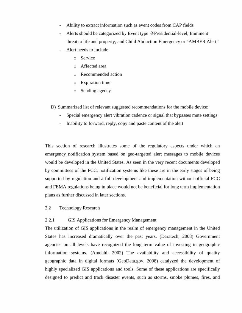
HURREVAC – National Level Example
Figure 7 - Hurrevac – Storm Intensity Prediction Application (Source: http://www.hurrevac.com)
This tool, developed by FEMA and the USACE in collaboration with Sea Island Software
Inc., provides hurricane path prediction and intensity information to emergency
management. (Hurrevac, 2007) It is made available free of charge to eligible emergency
management personnel. (FEMA, 2007) As seen in the figure above, HURREVAC is
designed for large scale disasters and is specifically designed for assisting in the evacuation
decision making process of an approaching hurricane that is to make landfall in the United
States. Input data for this tool includes datasets from the National Hurricane Center,
NOAA, and the National Weather Service; storm tracking information; wind speeds; and
ocean water temperature as part of the SLOSH model. (FEMA, 2007) The resulting files
are polygon files, which store attribute information on predicted storm path, wind, and rain
intensity information and are designed to help decision makers in the issuance of
evacuation notification.
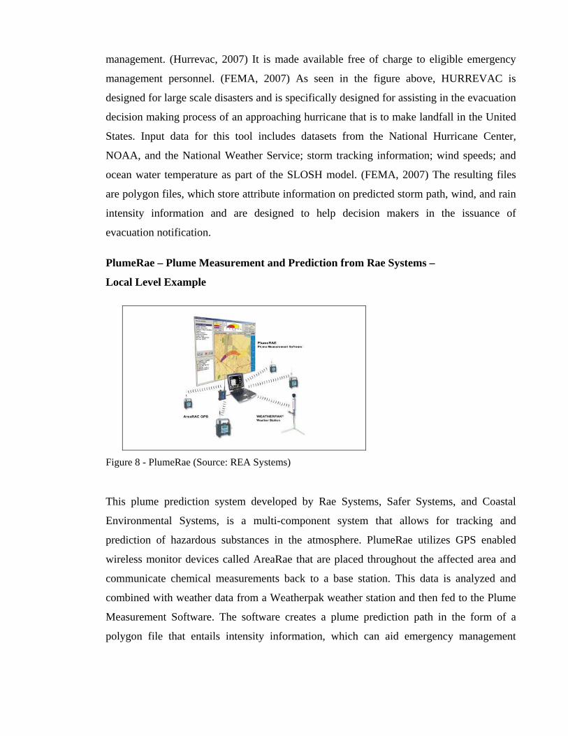
PlumeRae – Plume Measurement and Prediction from Rae Systems –
Local Level Example
Figure 8 - PlumeRae (Source: REA Systems)
This plume prediction system developed by Rae Systems, Safer Systems, and Coastal
Environmental Systems, is a multi-component system that allows for tracking and
prediction of hazardous substances in the atmosphere. PlumeRae utilizes GPS enabled
wireless monitor devices called AreaRae that are placed throughout the affected area and
communicate chemical measurements back to a base station. This data is analyzed and
combined with weather data from a Weatherpak weather station and then fed to the Plume
Measurement Software. The software creates a plume prediction path in the form of a
polygon file that entails intensity information, which can aid emergency management

decision makers in the disaster response and notification decision making process. (Rae
Systems, 2006)
The introduction to the two GIS applications above demonstrates that the outputs these
applications produce can be and are being utilized for emergency management purposes. In
many cases emergency management is the driving force behind such systems development.
This will be demonstrated clearly in later sections, which explain how these datasets would
be utilized in the proposed notification system.
2.2.2 Communication Technology – Short Message Services
Based on the recent successful Reverse 911 applications, (USC, 2005; Phelps, 2007), this
portion of the research shall shed light on the communication networks role and the
possibility of adding mobile devices to such a notification system. Placing thousands and
hundred thousands of wireless calls or transmitting that amount of text messages, in a short
period of time, utilizing various wireless networks, requires additional network capabilities,
or different network configuration than what is currently in place (FCC, 2008):
1) The networks need to be capable of carrying higher call volumes than during
regular operation in order to send thousands of messages out simultaneously.
(FCC, 2008, Wood, 2004) Network congestion can hinder further critical
disaster respond activities such as the transmission of regular 911 emergency
calls, as occurred in the Interstate 35 bridge collapse in Minnesota. (Phifer,
2007; Walsh, 2007)
2) The networks must be capable to send notifications to mobile devices based on
their actual location instead of their listed billing address.
In order to address these requirements, U.S. Congress has passed the previously mentioned
WARN Act as part of the SAFE Port Act and some of the results of that act have been
reviewed in subsection 2.1.4. This section should also demonstrate that systems similar to
the one proposed, are actively being developed around the world today.
Regular text messages or short message services (SMS) are transmitted as so called point to
point SMS. Point to point SMS has several limitations with regards to emergency
notification. According to CMSAAC, point to point messaging can result in network and

radio interface congestion, can experience significant delivery delays, and would severely
overwhelm the networks. This is because point to point SMS is targeting specific phone
numbers, so each transmission has to take place on its own transmission line. In the case of
an emergency notification system, transmission would occur from point one (network) to
point two (mobile device/ terminal). So each message to each device would take
bandwidth. Since this method targets specific mobile phone numbers, it is also lacking geo-
targeting capabilities. This being said, point to point SMS does not provide a workable
solution for emergency notification systems that need to notify possibly thousands of
mobile devices based on their location. (FCC, 2008)
Point to multipoint SMS, also known as cell broadcasting, allows for the transmission of
messages to multiple recipients based on a specific geographic area. The transmission is
based on radio cells of the network instead of specific devices (terminals). Currently each
cell is set up to reserve a portion of its capacity specifically for cell broadcasting,
preventing the network from being overwhelmed by the service when activated. Target
areas can be a single radio cell or the entire network area, allowing for transmission of
messages to large numbers of recipients and the possible integration of sophisticated GIS
systems to determine which areas are in need of notification. All devices within the target
area receive the message as an “unconfirmed push service”, meaning that during a
notification event, the transmitting networks would not receive a record of how many
messages were transmitted or who received them. (CBF, 2008; Wood, 2004)
As mentioned, in a few areas outside of the US such as the Netherlands (Clothier, 2005),
emergency notification systems utilizing cell broadcasting technology for alert systems are
already in place or are close to being finalized. These systems utilize the cell broadcasting
capabilities integrated into the Global System for Mobile communication standard (GSM).
(Wood, 2004)
In the United States, there is a list of network providers that deploy the GSM standard;
however only a few of them provide national coverage such as AT&T and T-Mobile, which
make up about 35 percent of the market. (GSM World, 2008; Beckman, 2008) Major US
wireless providers such as Verizon, Sprint Nextel, and Alltel, which make up about 60
percent of all US wireless subscriptions in 2008, (Beckman, 2008) utilize the Code
Division Multiple Access (CDMA) standard for their voice, broadband, and text messaging

on mobile devices. CDMA also has cell broadcast capabilities, but it is currently not
activated. The problem of utilizing this technology with several networks in place is that
competing network providers overlap in coverage areas. The complexity of integrating
several providers for an alert system and to provide secure message transmission needs to
be solved in order to make such a system possible and user-friendly. (Wood, 2004)
Possible options for implementation of cell broadcasting for an emergency alert system in
the United States are:
1) Make the adoption of a unified standard such as GSM or CDMA a legal
requirement for all network providers in the United States.
2) Develop an interoperability interface for cell broadcasting. An example of this is
the Cell Broadcast Broker™ developed by Cell Cast Technology. (Klein, 2007)
According to Cell Cast Technology, Cell Broadcast Broker™ allows for cell broadcasting
to be utilized in a safe and secure manner, integrating protocols from various wireless
network providers. (Klein, 2007) This would allow cell broadcasting to be a viable
technical option to transmit emergency alerts to mobile devices in the United States.
2.2.3 Location Based Services
Location Based Services is the capability of mobile communication devices to receive and
request information based on the actual physical location of the device. This information
can be provided to the mobile device by either the mobile network or the internet and is
provided to the mobile device by either a pull or a push service.
In order for such a “traditional” LBS system to work, several components need to be
synchronized with one another. As described in the “Lecture Notes on LBS, V. 1.0” by
Stefan Steiniger, Moritz Neun, and Alistair Edwardes, (University of Zurich 2006), these
components are:
- Mobile devices for the user to access the information such as PDA’s, cell
phones, laptops, or vehicle navigation systems.
- Communication Network (gateways) to transfer the information from and to the
mobile device.

- Positional component for the mobile devices to be spatially enabled. This can be
achieved via a GPS receiver, through mobile network positioning (WLAN
triangulation), a combination of the two, or radio beacons for indoor scenarios
such as in a museum. The accuracy of the positional component in the US is
indirectly mandated by FCC 94-102, as discussed previously in subsection
2.1.4.
- Service and Application Provider that is responsible for processing the service
request by the user. This is also referred to as the Location Management
Function that processes the positioning data, GIS data, and the informational
data.
- Data Provider that stores and supplies geographic data (GIS) and informational
data that would be provided upon request.
Figure 9 - LBS components (source: OpenLS)
As mentioned previously, location based information can be provided to a mobile device
based on pull services or on push services. With a pull service, the user requests
information. With a push service, the network senses the presence of the device within a

certain area and pushes the information. (OGC, 2008) The main difference between the two
services is that pull services are triggered by the user and push services are triggered by
positioning without the users request or consent. Open formats and established protocols
for LBS will be listed in the implementation discussion in section 4.
What makes LBS an interesting option for an emergency notification system is the push
service capabilities to transfer information based on location of the mobile device. The
gateway could potentially sense devices within the alert area and push emergency
notifications to those devices.
Another interesting possible feature, discussed in later sections, is the possibility of a
reverse pull service, in which emergency management would able to pull voluntarily stored
emergency information about the owner of the device in order to better prepare for a
disaster response or to customize the alert message. (ie. Emergency information profile)

3.0 Theoretical Solution
This section discusses the capability and functionality of an emergency notification system
based on GIS and LBS and/or cell broadcasting for mobile communication devices and
how this system would fit into the existing notification systems of the EAS. The proposed
system would support these existing systems for emergency notifications on short notice,
from a few minutes to 24 hours, as well as during and after the events. Additionally the
system would support the long term notification events, similar to Reverse 911. The idea is
to seamlessly integrate this system as an additional feature to the currently employed EAS.
Two approaches of notification systems will be presented and discussed. Both utilize GIS
applications to develop disaster prediction datasets for the basis of the area to be notified;
however they differ on how and what type of messages are being transmitted, and what
additional functionality these systems bring to emergency management agencies.
The technology research section has uncovered two possible options for developing a geo-
targeted notification system for mobile devices. One solution is based on point to multi
point short message services (cell broadcasting), which will now be referred to as the
passive system. The second possible solution is based on location based services, which
will now be referred to as the active system.
3.1 Emergency Notification Scenario and Timeline
The full extent of a possible EAS notification procedure scenario for a long term
notification event has been developed for this section, in order to clarify the specific role of
the newly proposed notification system. A long term event, such as a hurricane, is chosen
as it demonstrates a more complete picture on how the entire system would function, with
the last 24 hours of this long term event being comparable to some of the short term
notification events. The written depiction of this scenario is followed by a graphical
representation of the emergency notification timeline of events. The figure also includes
aspects of the proposed system.
3.1.1 Emergency Event
The life cycle of an emergency notification event begins with the classification of a natural
event or manmade situation as potentially threatening to the population or to property

within the US. This classification is done by authorities that have jurisdiction over the
threatened area. Depending on the type and scale of the event, this determination can be
made on the Federal, State, or local level; however the monitoring duty is mainly the
responsibility of Federal agencies as it is closely connected to homeland security tasks,
which are the responsibility of the Federal government, as stated on the DHS website:
“...we will prevent and deter terrorist attacks and protect
against and respond to threats and hazards to the nation.”
(DHS, 2008)
Most common types of longer term notification events in the United States are in
preparation for hurricanes, blizzards, and some cases of wild fires (HHS, 2008). Authorities
that commonly monitor for those kinds of events are NOAA, National Weather Service,
National Hurricane Center (NHC), the US Military, and the US Forest Service. The NHC
for example makes this type of monitoring publicly available on its website as seen in
Figure 11.
Figure 10 - NHC monitoring site (Source: NHC)
3.1.2 GIS Prediction Models
Once an event is classified to be potentially threatening, it is reported to the GIS divisions
of the monitoring agencies and emergency management agencies that are responsible for

ally . Before alerts are issued, GIS applications that were
urricane tracking and prediction
capability. In the example of the State of North Carolina’s Office of Crime Prevention and
potenti responding to the event
developed to predict disaster scenarios are used to generate first draft prediction models.
These models help to determine what areas the event will potentially affect, and what the
corresponding impact on population and property may be.
For example as mentioned in the research section 2.2.1, the GIS modeling software
Hurrevac, developed by FEMA and the USACE, provides h
Public Safety Department, this data in turn is utilized as input for the ArcMap extension
Hazards Analyst. Hazard Analyst (HA) was created by the State of North Carolina and
Watershed Concepts, a Division of HSMM|AECOM in 2007/2008 and will be ready for
use during the 2008 hurricane season. Although HA was initially developed for hurricane
events, it is also applicable for other disaster events such as droughts, ice storms, or any
other regional scale event. (Fogleman, 2008) This tool allows the NC emergency
management division to quickly intersect the storm swath prediction data (or any event
polygon data) with census data, population density grids, storm shelter data, EMS data, and
hospital bed information in order to assist with asset allocation, logistics reporting, and risk
assessment based on specific population types. HA is designed to assist the State of North
Carolina in preparing for disaster response; however the risk assessment datasets that are
generated could also be useful in pin pointing highly specified emergency notification
messages to the population in high risk areas. Risk can be assessed for several criteria
types, so very specific messages could be sent to areas that are threatened in various ways.
As an example, Figure 12 illustrates the Hazards Analyst risk assessment results run for a
proximity analysis of storm shelters and EMS services, whereas Table 6 explains the
logistics report and risk assessment capabilities of Hazards Analyst.

Figure 11 - Hazards Analyst Screen Capture (Hurricane Fran dataset)

Logistics Report Analysis Risk Assessment Analysis
The logistics report analysis function allows
for emergency management to quickly assess
and estimate how many response assets are
needed. This is highly customizable. For the
State of NC’s coastal areas, the general
assumption is that 5 percent of the affected
population is in need of assistance after a
hurricane event.
The risk assessment analysis function creates GIS
datasets and CVS format reports based on
customizable risk classifications and weighted risk
coefficients. The analysis can quickly be run on
several scenarios, so various output datasets could
be used to send several specialized emergency
notifications.
The result is a CVS table that can be utilized
for further analysis.
Hazards Analyst Risk Category and coefficient
sheet.
Figure 12 - Results of Risk Assessment in Hazards Analyst

Table 7 - HA Logistics Report and HA Risk Assessment (Source: Watershed Concepts)
The development of tools such as Hazards Analyst by the State of North Carolina and
Watershed Concepts represents one example of current GIS application development for
disaster preparedness and response. Many of these tools may potentially be useful for
emergency notification purposes, as they generate polygon files that depict certain risks,
intensities, or predictions, which could in turn be translated to highly geo-targeted
emergency notifications.
The initial results of the GIS analysis are then communicated to emergency management
agencies for further situation evaluation. The GIS prediction models are generally run
several times at certain intervals in order to get most up to date data included in the
analysis. Hurrevac data, for example, is generated in shorter intervals as the storm gets
closer to potentially making landfall. According to Fogleman, new Hurrevac data may be
available twice a day if the storm is 500 miles off the coast; as it approaches the coast, new
data may become available every four hours, depending on the progress of the storm and
the distance from the coastline.
3.1.3 EAS – Established Emergency Alert System
With the results of the GIS analysis, emergency management officers then generate an
emergency alert plan that is specific to the event and the analysis. In the case of a hurricane

in an area of the United States, television and radio broadcast stations and news agencies
are notified about the potential threat of a hurricane by the NWS 4-7 days prior the storms
predicted landfall. The general population is informed about the situation during regular
news coverage. As the storm gets closer to making landfall, emergency management must
make a decision for or against evacuation notification. According to the American
Meteorological Society, the closer the storm gets to making landfall, the more accurate the
prediction becomes, especially within the final 24 hours. (AMS, 1993) This is due to the
time tracking of the event, fewer variables involved in the prediction calculations, and the
advancement in the prediction models. (Cartwright, 2007) The call for evacuation or other
emergency instructions in preparation for an approaching hurricane is generally made no
later than 24 to 48 hours prior to the hurricane making landfall. Emergency alert messages
are sent to the affected population via television and radio through EAS. Alerts are
generally associated with a unique beep tone, followed by specific EAS messages on a
black screen, which overrides current programming. The Alert message is not static, but
runs similar to a ticker across the screen. This screen will last for about 1-2 minutes, before
the programming returns to its original broadcast. (FCC, 2007; FEMA, 2006) Figure 13 is
an example of an Amber Alert in Illinois.
Figure 13 - EAS Alert Message Example (Source Illinois EAS)
Evacuation announcement are broadcasted several times a day, increasing in frequency
closer to the event with updated information.
The final 24 hours of a long term notification event can also be compared to a short term
event. Short term notification events in the United States may be associated with tornados,

earthquakes, fires, terrorist attacks, or tsunamis, whereas some of these type of event
generally have a warning time of only a few minutes. (HHS, 2008)
GIS analysis continues to operate or is performed for the first time for a short term
notification event as soon as knowledge of the event becomes available. In addition to mass
media notification of EAS, emergency management now also utilizes the GIS output
datasets to make use of the Reverse 911 notification system for communities and regions
that operate such systems. This system utilizes dispatch software to transmit voice recorded
messages to all landline telephone numbers listed in the emergency 911 database, based on
specific geographic areas. As situations evolve several additional messages may be sent to
affected households if necessary, as well as in the post disaster era, if the lines of
communications are functional.
3.1.4 Mobile Device Notification in addition to EAS
The proposed system fits into the current established EAS similar to how Reverse 911
systems are currently being utilized. Although Reverse 911 is currently not officially part
of the national EAS, communities that have these systems available utilized them in
addition to EAS. The proposed system would notify mobile devices that are in the affected
area are via text message, whereas Reverse 911 transmits voice alert notification to landline
telephone connections.
3.2 Description of System
The main objective of the geo-targeted emergency notification system for mobile devices is
the ability for emergency management to send text notifications to mobile devices that are,
at time of message transmission, within the affected area of an event. Research has shown
that the WARN Act has forced the FCC to pursue options of implementation of such a
system within the United States. On April 10th, 2008, the FCC agreed to a plan that would
add text messaging to the current EAS. According to press releases, Wireless network
providers have ten months to comply with this new regulation and upgrade their networks
and devices. Major service providers such as T-Mobile, Verizon, Sprint Nextel and AT&T
have announced that they will participate. (Bachelor & Rizzo, 2008)
As result of the research conducted for the technical research section, two possible methods
of geo-targeted notification have been identified. The approach of purely focusing on

emergency notification of mobile devices will be addressed by the description of the
passive system, as this system is similar to the system possibly pursued by the FCC. The
second system, which goes beyond simply notifying mobile devices, is discussed in the
description of the active system.
3.2.1 Description of Passive System
The proposed passive system is based on point to multi point SMS (cell broadcasting).
These messages can be sent to a vast number of recipients without overwhelming the
network capacity, because the messages are sent out or broadcast through a single line
transmission to specific radio cells (areas), not specific devices. All devices located in those
specific cells would receive the message. Since massages are sent out utilizing this method,
the sender does not have any information on who received the messages, or how many
messages were sent or delivered.
The message itself would be authored by trained emergency management staff, formatted
to the guidelines and protocols of the FCC’s Commercial Mobile Service Alert Advisory
Committee. Preliminary guidelines that have been provided to this point through the
“Notice of Proposed Rulemaking” from Jan 3rd, 2008 are as follows (FCC, 2008):
- Text based alert
- CAP Version 1.1 is to be utilized (CAP, 2005)
- Limited to 90 characters
- Use common NOAA alert codes
- Display a recommended action
- Display the issuing agency
- Post an expiration time of treat
- Message is to be in English
The message and affected area information would then be provided through a cell broadcast
broker to the wireless communication networks to broadcast. (Klein, 2007; Wood 2004)
The following figure depicts the cell broadcasting process graphically. The alert message is
broadcasted to all radio cells shown in green. Mobile devices within those cells, would
receive the message. Some green cells may have no devices inside of them, others
thousands.

Figure 14 - Passive System Graphic (individual items not shown to scale)
3.2.2 Desired Outcome of Passive System
The desired outcome of the passive system is that every mobile device within an affected
area receives an alert text message, without overwhelming and potentially collapsing the
communication networks needed for disaster response work or regular communication.
Alerts should have a unique indentifying feature associated with them, which could be a
unique ring tone, vibrate function, or font type, which should be protected so unauthorized
organizations or people are unable to mock broadcast emergency alert messages. People
should also have the option to unsubscribe from receiving alert messages, in case they feel
their privacy is being invaded.

3.2.3 Description of Active System
The proposed active system is based on location based services in combination with GIS
applications. As mentioned in the research section, LBS relies on several components in
order to function.
1) Spatially enabled mobile device
2) Communication network (gateways)
3) Positioning component
4) Service provider
5) Data provider
For emergency notification purposes, the network providers would in this case take on the
service provider role, whereas emergency management agencies would take on the data
provider role and are in partial control of the gateway. The data to be transmitted would be
the alert message similar to that described in the passive system.
Messages would be transmitted by the following outline:
1) The network would actively scan the affected area for mobile devices, utilizing
the disaster extent generated by GIS analysis that was provided by emergency
management. Since all mobile devices in the United States are spatially enabled,
either through GPS or network triangulation, the scan would provide a
temporary XY coordinate for each mobile device within the affected area. All
devices that return location information, qualify for an alert message.
2) Mobile device users would also be able to voluntarily store an emergency
profile on their device, which stores potentially crucial information that may be
helpful for emergency management agencies to prepare and respond to a
disaster or coordinate evacuation assistance. During the scan for devices this
profile information could be queried via a reverse pull service by the gateway.
Stored information could possibly include:

a. Mobility information i. In wheel chair ii. Over the age of 70
b. Language preference i. English (default) ii. Spanish iii. Chinese iv. ...
b. Lack of personal transportation i. Yes ii. No
d. Single parent with # of children e. Illnesses
i. Diabetic ii. Alzheimers iii. ...
3) To complete the notification process, the communication network providers
transmit the emergency alert message to the devices that are within the disaster
extent via location based push service.
The benefit of the active system over the passive system is that emergency management
would get an estimated headcount of people that are in the affected area by reviewing the
number of devices that returned coordinates. In addition, the data collected from the
emergency profile would provide valuable information that could assist in evacuation
assistance and the post disaster response, such as search and rescue activities. The
following depicts the location based active system graphically. The process is broken up
into three phases.
Phase I represents the initial scan of the network for mobile devices within the disaster area
and the response of the devices transmitting XY coordinate and emergency profile
information back to the server. Duplicate location value returns of devices by various
transmitter stations are to be sorted out by the gateway before information is transmitted
back to emergency management.
Figure 15 - Active System Phase I (individual items not shown to scale)
Phase II represents the emergency alert transmission from the emergency management
agencies, through the gateway, to the mobile devices via location based push service. All
devices within the disaster are receiving the alert notification.

Figure 16 - Active System Phase II (individual items not shown to scale)
Phase III represents the additional possibilities the active system provides, such as:
A) Analysis of the emergency profile data to coordinate the response to special needs
situations. (I.e. evacuation assistance for people who lack personal transportation.)
B) The estimated number of people in the affected area allowing for better post disaster
response in terms of needed assets such as water, food, etc.
C) The possibility to send highly specific notifications, such as personalized evacuation
routing information to alleviate congested road sections.

All location based services that are being employed commercially are options that could
potentially assist in the notification and response process.
Figure 17 - Active System Phase III (individual items not shown to scale)
3.2.4 Desired Outcome of Active System
The desired outcome of the active system is mainly identical to the desired outcome of the
passive system, in that every mobile device within an affected area receives an alert text
message without overwhelming and potentially collapsing the communication networks
needed for disaster response work. The security and privacy aspects of the active system
are also the same as the passive system. In addition to those aspects, the active system

should provide valuable information about the affected population within the disaster area.
This information would be used for evacuation assistance proposes, customized evacuation
routing to alleviate congested roadways, preparation of the disaster response, and post
disaster assistance. The active system therefore is not only a notification system, but links
directly with the preparedness and response activities of emergency management. Section 6
discusses the highlights of the active system in more detail.

3.3 Graphical Depiction of EAS Event Timeline
Figure 18 - EAS Timeline Scenario - Day 7- Day 1
50

Figure 19 - EAS Timeline Scenario - final 24 hours
51
52
Figure 20 - EAS Timeline Scenario - post event

4.0 System Implementation Discussion
This section discusses the possible implementation of an emergency notification system
based on LBS and/or cell broadcasting for mobile devices in the United States. This topic
raises questions that should be reviewed and analyzed. Most of this section will commit
itself to the active system proposed in section 3, as the FCC and the Federal government as
of April 2008 have already taken steps towards adopting regulation for a system that would
be similar to the passive system, focusing purely on notification. The following subsections
will shed light on the major efforts of implementation and gives a more technical view of
the individual processes involved.
Subsection 4.4 lists the implementation milestones graphically, which may help to present a
better overview of the implementation by depicting the individual stakeholders of
implementation and their role.
4.1 Items to consider for Implementation
As mentioned, the implementation of an emergency system based on mobile technology
involves a list of items that should be reviewed and discussed by a board of experts such as
the CMSAAC. The following subsections will provide important information in this regard
and will help to identify crucial aspects and stakeholders for such a development.
4.1.1 Scale of Implementation
The scale at which these systems are to be implemented is of great importance. Should the
system be developed on Federal level for the entire country or through grass root
development fueled by local and State governments? Should smaller test areas lead to
further expansion of the system?
To answer these types of questions, one should consider the consequences of the multiple
options that exist and weigh the best solution. Development of several smaller scale
systems by efforts on the local level, may produce several functioning systems, however
without a regulatory structure in place for developing parties to conform to, these systems
may be developed on a proprietary basis. Such a basis may lead to inability of the systems
to interoperate with each other and might prevent a future incorporation into the national

seamless EAS efforts. Federal guidelines and protocols are therefore particularly important
as is a vision of how the systems are supposed to operate, similar to that described in
section 3. In some cases, it takes political pressure to force private organizations or
businesses to adhere to interoperability standards, as seen in the FCC adoption of the plan
in April 2008 to include SMS in emergency alert messaging. Competing network providers
are now required to comply to FCC regulations in order to participate.
From the Federal point of view, once the vision, standards, and regulations are in place, it
may be more beneficial and cost effective to have communities that have high interest in
the development of such systems pave the way on the local level with Federal funding
support, instead of an overall Federal implementation. This will automatically generate test
areas in locations that are vulnerable to disasters. Systems that prove to be effective will
establish themselves, gain interests from other communities, and expand geographically.
Interoperability standards will ensure that these various systems can interact with each
other for nationwide adoption.
In summary it would be crucial to have a Federal vision, Federal guidelines, and Federal
regulations in place in order to make the development of this new generation emergency
notification possible, and in the case of the active system information systems, more
effective and expandable for the national level.
4.1.2 Open Source Infrastructure
Since emergency notification systems require coordination of many stakeholders,
interoperability is of high importance. Several government agencies, private vendors, and
consultants need to be able to read and utilize each other’s products and data, so common
standardized interfaces are needed for this to be possible. Some of the existing standards
that may be of importance in the implementation of a system as is proposed will be
discussed in this section. Additional protocols may need to be created for full development
and implementation to occur. Some standards referenced below have been developed by
International Organization for Standardization and the Open Geospatial Consortium.
Since geographic information is a major part of this system and some outside of the GIS
industry operating agencies or businesses are involved in the development of these systems,
the ISO standard 19119:2005 should be adhered to. As described on the ISO website:

“ISO 19119:2005 identifies and defines the architecture patterns
for service interfaces used for geographic information, defines its
relationship to the Open Systems Environment model, presents a
geographic services taxonomy and a list of example geographic
services placed in the services taxonomy. It also prescribes how to
create a platform-neutral service specification, how to derive
conformant platform-specific service specifications, and provides
guidelines for the selection and specification of geographic
services from both platform-neutral and platform-specific
perspectives.”
(ISO, 2008)
There are several other ISO standards that are of importance to this work. ISO 19111:2007,
based on the older version ISO 19105, describes standards for referencing locations with
the use of coordinates. This is highly important during the scanning of the affected area for
mobile devices as described in section 3.
“ISO 19111:2007 defines the conceptual schema for the
description of spatial referencing by coordinates,
optionally extended to spatio-temporal referencing. It
describes the minimum data required to define one-, two-
and three-dimensional spatial coordinate reference
systems with an extension to merged spatial-temporal
reference systems. It allows additional descriptive
information to be provided. It also describes the
information required to change coordinates from one
coordinate reference system to another. In ISO
19111:2007, a coordinate reference system does not
change with time. For coordinate reference systems
defined on moving platforms such as cars, ships, aircraft
and spacecraft, the transformation to an Earth-fixed
coordinate reference system can include a time element.”
(ISO, 2008)
The development of the location bases service is most likely the most important and
complex area, since the most differing industries have to be able to exchange information.
ISO 19132:2007 describes basic principles of LBS and will be discussed in more detail;
however it does not provide rules or other agreement guidelines that need to be provided by
government regulation as described in the preceding paragraph.
“ISO 19132:2007 defines a reference model and a
conceptual framework for location-based services (LBS),
and describes the basic principles by which LBS
applications may interoperate. This framework references
or contains ontology, a taxonomy, a set of design patterns
and a core set of LBS service abstract specifications in
UML. ISO 19132:2007 further specifies the framework's
relationship to other frameworks, applications and services
for geographic information and to client applications.”
ISO 19132:2007 addresses, for an LBS system, the first
three basic viewpoints as defined in the Reference Model
for Open Distributed Processing (RM-ODP, see ISO/IEC
10746-1). These viewpoints are the Enterprise Viewpoint –
detailing the purpose, scope, and policies of the system;
Information Viewpoint – detailing the semantics of
information and processing within the system;
Computational Viewpoint – detailing the functional
decomposition of the system.”
(ISO, 2008)
In 2005 the OGC published a document specifically directed towards the open
implementation of service platforms for OpenGIS Location Services (OpenLS). These
platforms, often referred to as GeoMobility Servers (GMS), are part of the framework of
LBS. This OGC document is based on the ISO 19105 standard and contains schemas and
guidelines that are important for the implementation of an open source LBS. (OGC, 2008)
Subsection 4.3 will list some of these schemas, which are of importance for the individual
components. As mentioned in section 3, GIS emergency extent data is available from

various agencies and organizations, which may all be using different GIS formats. In order
to ensure that emergency extent data can be integrated into the active or passive system
regardless of its source, it should be provided in an open format. GML is an OGC defined
XML based schema to describe geographic features for open exchange and is suggested in
this work. The OGC 03-105r1 - ISO/CD 19136 provides detailed information on GML.
(OGC, 2008)
4.2 Component Discussion for the Active System based on LBS
The following subsections describe the six main components of implementation for the
active system. Specific methods or standards are given as examples of how the system
could potentially be implemented and which stakeholder would be responsible for the
implementation of the milestones. Some of the schemas provided by ISO or the OGC will
need to be modified in order to incorporate the functionality proposed in the active system.
Examples listed below are based on ISO and OGC schemas but also include modifications
that are specific to the active system.
4.2.1 GIS Emergency Data
The parties responsible for providing disaster extent data would be the monitoring
government agencies, such as the ones listed in Section 3.1.1. In addition, emergency
management agencies on various levels, such as the State of North Carolina, that run GIS
prediction models or analysis on disaster situations would also play a vital role in sourcing
this data. Since proprietary file formats are to be avoided, datasets need to be converted to
an open format such as GML before being transmitted to the communication networks. If
the source proprietary GIS software systems are not capable of converting the dataset,
translating tools such as FME by Safe Software should be utilized. (Safe, 2008) Specific
data import models would be created that automate the translation of the datasets to GML.
These models would be linked to the cell broadcast broker or the gateway for translation of
the GIS data into GML.

Figure 21 - FME translation sample
A translated ESRI shapefile of a simple disaster extent would look similar to this:
<?xml version="1.0" encoding="UTF-8"?> <gml:FeatureCollection xmlns:gml="http://www.opengis.net/gml" xmlns:xlink="http://www.w3.org/1999/xlink" xmlns:xsi="http://www.w3.org/2001/XMLSchema-instance" xmlns:fme="http://www.safe.com/gml/fme" xsi:schemaLocation="http://www.safe.com/gml/fme Plume_Buffer_area_GML.shp.xsd"> <gml:boundedBy> <gml:Envelope srsName="EPSG:2267" srsDimension="2"> <gml:lowerCorner>2596488.07151437 267974.362145707</gml:lowerCorner> <gml:upperCorner>2961299.78212923 710694.234038651</gml:upperCorner> </gml:Envelope> </gml:boundedBy> <gml:featureMember> <fme:Plume_Buffer_area gml:id="idcebe7ff0-d6ee-4162-bffd-26c32dabb094"> <fme:AREA>155275429.571</fme:AREA> <fme:PERIMETER>50131.6031805</fme:PERIMETER> <fme:QUAD_ID>1</fme:QUAD_ID> <fme:SOURCE_CIT>BASE1</fme:SOURCE_CIT> <fme:BUFF_DIST>105600</fme:BUFF_DIST> <fme:DISASTER_T>Toxic Plume</fme:DISASTER_T> <fme:THREAT>Chlorine</fme:THREAT> <fme:DATE>20080528</fme:DATE> <gml:surfaceProperty> <gml:Surface srsName="EPSG:2267" srsDimension="2">

<gml:patches> <gml:PolygonPatch> <gml:exterior> <gml:LinearRing> <gml:posList>2858944.76762214 272174.409655258 2821987.06887114 271055.865923733 2821950.13344236 271056.51593563 //Coordinate points of all vertices would be listed here. This section was shortened for display purposes. 275724.310731381 2876351.73018123 274155.152376965 2869533.75807475 273029.50062643 2862656.76262303 272352.175693512 2858944.76762214 272174.409655258</gml:posList> </gml:LinearRing> </gml:exterior> </gml:PolygonPatch> </gml:patches> </gml:Surface> </gml:surfaceProperty> </fme:Plume_Buffer_area> </gml:featureMember> </gml:FeatureCollection>
Table 8 - GML example of a disaster area extent dataset
4.2.2 Mobile Devices
As mentioned in subsection 2.1.4, FCC regulation 94-102 plays a vital role in the
implementation of the active system, as it mandates all mobile devices to be spatially
enabled in order to be located when placing 911 emergency calls. Wireless providers have
conformed to this requirement since the phase II regulations were adopted in 2001, so most
devices in circulation today fulfill this requirement.
Besides the physical capability of the mobile device itself, the active system also requires
the participation of another stakeholder benefiting from this alert system. The users of the
devices, the residents of the United States, need to provide the additional emergency profile
information stored on his/her personal device and furthermore enable the emergency alert
functions on the device in order for this system to be successful. Even though emergency
alert messages do not fall under the CAN-SPAM Act of 2003, which shields consumers
from unwanted commercial messages sent to their mobile devices (FTC, 2004), the option
of disabling alert message needs to be provided in this case, especially since this system
would give location information to government authorities. It would be the emergency

management agency’s responsibility to provide citizen outreach and educate the population
of the importance of participating in the wireless alert system.
4.2.3 Service Provider and Gateway Services
The stakeholders that would be responsible for performing the scan of mobile devices
within a specific area and transmission of emergency alerts are the wireless communication
providers and emergency management agencies. This would be achieved through the
service of gateways that are operated by the network providers, with oversight from the
trained emergency management staff. According to OpenLS 9.2, the gateway is the
interface between the GeoMobility server and location server through which OpenLS
services obtain position data for mobile devices. (OGC, 2008) Section 9.2.1 of the standard
lists detailed information and several use case scenarios. The scenario that is of interest for
the active system is the “Client requests multiple mobiles’ immediate location” use case. In
the active system, the network is requesting the location information of mobile devices and
would therefore send a request to the gateway to locate all devices within the geographic
extent. The disaster extent GML information would be embedded in this service request
similar to that displayed in Table 8. Detailed research and testing would need to be
conducted to correctly incorporate the geographic extent to request location information for
all devices within that area and to request the emergency profile information to be returned
as well.

<SLIR> <InputGatewayParameters priority="HIGH" locationType="CURRENT_OR_LAST" requestedsrsName="WGS84"> <InputScanArea> <?xml version="1.0" encoding="UTF-8"?> <gml:FeatureCollection xmlns:gml="http://www.opengis.net/gml" xmlns:xlink="http://www.w3.org/1999/xlink" xmlns:xsi="http://www.w3.org/2001/XMLSchema-instance" xmlns:fme="http://www.safe.com/gml/fme" xsi:schemaLocation="http://www.safe.com/gml/fme Plume_Buffer_area_GML.shp.xsd"> <gml:boundedBy> <gml:Envelope srsName="EPSG:2267" srsDimension="2"> <gml:lowerCorner>2596488.07151437 267974.362145707</gml:lowerCorner> <gml:upperCorner>2961299.78212923 710694.234038651</gml:upperCorner> //only the spatial extent (corner point) of the alert area file is shown here for display purposes </InputScanArea> <InputMSID> <InputMSInformation msIDType="ALL" msIDValue="ALL"></MSInformation> <EmergProfile>”ALL ENTRIES“</EmergProfile> </ InputMSID > <RequestedQoP responseReq="No_Delay" responseTimer="20"> <HorizontalAcc> <Distance value="125"></Distance> </HorizontalAcc> </RequestedQoP> </InputGatewayParameters> </SLIR>
Table 9 - Possible Location Request Example (based on OpenLS 9.2.2)
After the request for location has been submitted by the gateway service, the devices within
the specific area of the request would return the following response to the gateway. This
modified sample is based on OpenLS 9.2.2 and also includes the possible return of
emergency profile information as outlined in section 3.2.3 of this work.
<SLIA requestID=”1”> <OutputGatewayParameters> <OutputMSID> <OutputMSInformation msIdType="msisdn" msIDValue=” +12026899915”> // Device ID <Position>
<gml:Point><gml:pos>37.656767 -78.367565</gml:pos> // Location Information </gml:Point> </Position> <EmergProfile> // Profile Information <mobilityInfo>wheelchair</mobilityInfo> <LanguagePref>xls:lang:Spanish</LanguagePref> <Illness>Alzheimer’s</Illness </EmergProfile>

</OutputMSInformation> </OutputMSID> </OutputGatewayParameters> </SLIA>
Table 10 - Possible Location Response Example for one return (based on OpenLS 9.2.2)
For preferred user language settings the “lang” attribute of the XLS element could possibly
be used to specify a preferred language to help format language preferences of alert
notifications automatically. (W3C, 2006)
The emergency profile data collected during the location request gets submitted to the
emergency management agency involved in the preparation and response to the disaster. It
can be imported into a GIS and be used for further analysis, preparation, and response to
the event. Possibilities on how the actual alert message would be transmitted in the active
system will be discussed in section 6.0, as a combination of the active and passive system
may be a feasible option.
4.2.4 Content and Data Provider
The content and data provider for the alert message itself would be the emergency
management agencies as they are trained and currently responsible for issuing the alerts for
EAS. In order to adhere to open source standards, the alert would be provided in the XML
standard CAP 1.1. (CAP, 2005) Using the example noted in section 3.2.1, a text alert
message could look similar to the following:
<?xml version = "1.0" encoding = "UTF-8"?> <alert xmlns = "urn:oasis:names:tc:emergency:cap:1.1"> <identifier>KSTO1055887203</identifier> <sender>FEMA</sender>> //Issuing Agency <sent>2008-05-28T14:00:00-07:00</sent> //Date and time issued <status>Actual</status> <msgType>Alert</msgType> <scope>Public</scope> <info> <category>Met</category> <event>HAZARDOUS MATERIAL WARNING</event> // Type of event <responseType>evacuate</responseType> <urgency>Immediate</urgency> <severity>Severe</severity> <certainty>Observed</certainty> <eventCode> <valueName>same</valueName> // backwards compatible with SAME

<value>HMW</value> //SAME alert code </eventCode> <expires>2008-05-29T6:00:00-07:00</expires> //Expiration time frame <senderName> FEMA </senderName> <headline> HAZARDOUS MATERIAL WARNING </headline> <description> CHLORINE SPILL ON INTERSTATE 35 AT EXIT 47B </description> <instruction>SHELTER IN PLACE – REMAIN INDOORS WITH WINDOWS SHUT</instruction><contact>FOR HEALTH EMERGENCIES CONTACT LOCAL 911</contact> </info> </alert>
Table 11 - Sample Alert Message based on CAP 1.1 (XML)
Due to the highly specific information returned during the scan for location of mobile
devices in combination with the emergency profile data, a series of additional services
could be provided to people who are within the disaster extent area. Most of these services
fall in line with standard LB services such as personalized routing services or presentation
services and will not be discussed further at this time.

4.3 Implementation Milestone Graphical Overview
Figure 22 - Implementation Milestones
64

65
5.0 Results of Research
The research done in this work in regards to a geo-targeted emergency alert system for
mobile devices based on GIS has shown that such a system could be a valuable addition to
the current United Sates Emergency Alert System (EAS). This is based on findings that
people respond to personally receiving emergency notification in a more responsive manner
than through mass media notification alone and the lack of ability to transmit alerts to
mobile devices. Even today with EAS and Reverse 911, some people do not receive
emergency notification, so there is a need to add geo-targeted text based messaging to
mobile devices for emergency notification. As shown, more and more people exclusively
rely on mobile communication technology and people are becoming more mobile in their
work and daily lives. As mentioned previously, the need for such a system is additionally
validated by the FCC accepting a plan in April 2008 to incorporate text based alerts to
mobile devices into EAS or the new FEMA program IPAWS. With the acceptance by the
FCC, the regulatory aspects of implementing such a system are now being finalized.
During the FCC EAS summit on May 19, 2008 entitled: “Emergency Alert System:
Promoting an Effective Emergency Alert System on the Road to a Next Generation EAS”,
speakers mentioned that open formats such as the XML based Common Alert Protocol
(CAP) are crucial aspects of the next generation alert systems.
The FCC adopting this plan is of great importance as the technology level of some wireless
networks and network providers in the United States are currently not capable of
implementing a system based on cell broadcasting. The FCC acceptance of adding wireless
notification, puts pressure on the network companies to develop interfaces and protocols in
order to comply with the FCC requirements to allow for cell broadcasting to be utilized and
to integrate open source technologies.
Cell broadcasting turned out to be the leading and seemingly preferred method for vast geo-
targeted transmission of alert messages. However an alternative method utilizing location
based services could provide additional emergency management service options on top of
alert notifications alone. Research has shown that current open source standards such as
OpenLS and several ISO standards can be utilized to setup gateways and data frameworks

66
to develop an alert system based on LBS. The mobile devices currently in use in the United
States are spatially enabled and would be capable in operating in such an alert system.
The current developments in GIS applications in the US market for emergency
management and disaster events can in most cases provide the necessary area extent
datasets required for the location aspects of the systems. Market research predicts an
increasing interest in developing GIS based emergency management planning and response
tools by government agencies for some time to come. (ESRI, 2008; Daratech, 2008)

67
6.0 Analysis of Research Results
The creation of the CMSAAC by the FCC and IPAWS by FEMA are crucial steps toward
more technologically enhanced emergency notification systems in the United States. The
results of the research demonstrate that geo-targeting mobile devices as part of the
emergency alert system are a priority item for FEMA and the FCC. Researching current
technology resulted in the development of two concepts that could realize a system that
includes geo-targeted notification. The passive system (3.2.1), based on cell broadcasting
and the active system (3.2.3) based on location based services.
Since the proposed concept for the passive alert system based on cell broadcasting is
similar to the geo-targeted text message system the FCC now has accepted, the following
questions arises.
How would the proposed active system, based on location based services, possibly be
utilized in the future? Would there still be a need for such a system? Can such a system be
incorporated in the path that the FCC and FEMA are taking?
In order to evaluate a need for the active system, the implemented passive system needs to
be analyzed for its effectiveness and its shortfalls compared to the active system. The
passive system seems to be highly effective in sending alert messages via point to multi
point SMS. Sending large numbers of messages in an effective manner is one of the main
requirements of the system (3.2.2). The passive system is also highly scalable, so an
implementation of this system on a national level is possible and desired by the FCC and
FEMA.
As mentioned in subsection 2.2.2, the cell broadcast transmitter (network provider) of the
emergency alert message has no information about the recipients or even how many
messages were transmitted or received. Realizing that current EAS systems such as
television and radio alerts do not supply these statistics either, this may be acceptable, as
the main concern for FEMA and the FCC is to transmit notifications. In that sense it’s
difficult to argue the point that the passive system is limited to transmitting emergency
notifications without gathering additional information. In comparison with the active
system, however, this is one of the identified disadvantages of the passive system. The

68
information collected by the active system would be helpful during the notification process
itself by allowing language preferences and other customized options, but the real
advantage of the active system is to allow emergency management to gather the emergency
profile information stored on the devices. This type of information can be of assistance in
the decision making process for the preparation for an event, during an event, and for the
post event operations (i.e. search and rescue). That and the fact that the FCC and FEMA are
currently developing guidelines for a cell broadcasting based system suggest that the active
system could perhaps play a supporting role to the passive system, in which notifications
are being predominately transmitted via cell broadcasting. The active system would be
mainly utilized as a data collection tool and a tool for highly specialized notifications. The
data collected, in combination of GIS applications and analysis, would allow for more
detailed and more refined geo-targeted alert notifications. The active system could provide
emergency management with highly detailed information of the affected population and
could still be utilized for specific personal notification of individuals via push services if
needed, since special needs information is collected for specific devices.
The possible scale of implementation of the active system for emergency management
purposes in addition to the passive system would have to depend on results of a test area,
such as an urbanized community along the Atlantic coast of the United States that is prone
to natural disasters. Items that are important to further expansion of the systems and to call
it successful would be:
- Population buy-in. Participation of the population in completing the emergency
profile information, keeping it current on their devices, and enabling the
notification option. To keep the information current, the profile should possibly
reset itself every twelve months and alert the owner to re-enter the information.
- Success rate of scanning the affected area for devices. Percentage of positive
returns.
- Ability to process and analyze the possibly vast amount of data collected. Is that
amount of information helpful or the cause of additional problems?
- Network and gateway capability and capacity to transmit specific messages via
location based push services without overwhelming the system.

69
In summary, geo-targeted emergency alert notification for mobile devices, as described in
the passive system, is a possibility with government enforcement of regulations and most
likely will be available in the United States within the next few years, whereas the active
system could potentially play a vital role in the emergency management and notification
process in the future, in combination with a passive system.

70
7.0 Conclusion
The concept development of the two geo-targeted emergency notification systems for
mobile devices (Section 3) has resulted in one concept system that is similar to the system
the US Federal government is soon to start adopting regulation for, which adds geo-
targeted notification of mobile devices to the alert system. The other system blends the idea
of emergency notification with emergency management via reverse pull services of mobile
devices to gather information about the affected population in a specified area. In addition
to blanket notification of the alert area, specific messages could be sent based on analysis
of the collected information. The capability of providing personal emergency notification,
such as evacuation procedures and routing information, possibly for every device within a
given area, would most likely depend on the calculating power of the analysis tools and the
transmission capacity of the network. As both are expected to expand over time with the
enhancement of technology, personal emergency notification unique to each mobile device
may become a realistic option in the future. Participation of the population is very
important for the success of such a system. As mentioned in section 6.0, device owners
must be willing to enable to emergency notification option of their device and fill out the
emergency profile information to ensure success. Nathan McClure, a communications
engineer and an expert in the emergency notification arena, states that keeping information
current is crucial for systems like the active system to be successful. Outdated or false
information can be worse than no information in some cases. (McClure, 2008)
With the increasing number of people exclusively relying on wireless communication
devices, the need for a geo-targeted alert notification system for mobile devices is there.
The implementation of a system such as the passive system is indeed possible and is
targeted to be in place in the United States by 2010. (FCC, 2008) The active system
provides an alternative to the passive system and may be of interest in the future to
supplement a system similar to the passive system. For both systems the technology is
available, but Federal leadership, in the form of a vision, regulation, and standards, is
needed for the implementation and to ensure a seamless emergency alert system for the
entire country.
71
7.1 Summary of Research
In this work two conceptual systems of emergency notification based on GIS and geo-
targeted emergency notification for mobile devices have been developed. The concepts are
based on the broad research areas of emergency management and technology. The
emergency management research topics include human behavior in emergency notification
scenarios, stakeholders of emergency management in the United States, and current
regulatory aspects of emergency notification in the United States. This portion of the
research solidifies the justification for proposing such notification systems, whereas the
technological research areas explore to possible implementation of such systems.
Technological topics include current GIS applications for emergency management,
communication technology, and a description of current location based services.
The theoretical solution section depicts a possible current US emergency alert system
scenario and how the proposed systems could potentially be integrated. This section is
followed by the description and the desired outcome of the each system and a discussion on
the possible implementation of the systems. The implementation discussion covers the
areas of open source infrastructure and the roles of the specific stakeholders of the
implementation milestones.
7.2 Future Research
Further detailed review of FCC regulation FCC 08-99A1 needs to be performed to develop
specific implementation plans of the passive system. In addition, as technology evolves, the
need for continued and future research in the fields of emergency management and
notification services is required for this topic. The active system based on LBS requires
more research into the area of network capacity and stability due to the surge increase of
usage during the scanning of the alert.
In addition, new available methods of transmitting geo-targeted alert messages to mobile
devices in efficient and effective ways need to be continuously monitored and researched.
Other messaging systems need to be explored that allow for this type of message
transmission. As mobile technologies become more integrated with GPS, GPS messaging
(GPSReview, 2008) may provide a suitable alternative to SMS services and should be
investigated further, as it potentially could alleviate wireless network specific issues

72
associated with providers, standards or strain on system capabilities. GPS notification
systems may also have an advantage during power outages or damages to wireless
transmission towers and network installations as it relies on the GPS satellite system, which
is somewhat removed from the dangers of natural disasters on earth.
An alternative approach that should be investigated would be to take advantage of the
enhanced accessibility of mobile devices to the internet, as WIFI services become more
available through city wide or regional wide service providers. The utilization of the
internet for emergency notification should be evaluated in further research as well.
(Reardon, 2007)
It would potentially also be beneficial to conduct further research on how the presentation
of the text alerts and aspects such as color scheme or wording influences response behavior.
7.3 Personal Statement
Since this area of research is currently very popular in the United States, it was challenging
to keep current technological and regulatory developments in sync with the ideas for the
proposed systems. As the preparation of this thesis ran parallel to actual proposed
regulations and the development of standards for a similar system by the CMSAAC, an
attempt was made to incorporate several recommendations from the January 3, 2008
released FCC document in this work. Some of the recommendations may have turned out
to be obsolete with the FCC adoption of FCC 08-99A1 (FCC, 2008). The main challenge
was to develop a concept of a system and incorporate some of the regulatory aspects that
were being released at the same time. The subsequent release of new Federal documents
and regulation in turn created the need to revise certain aspects of the concept along the
way.
Nevertheless, the proposed systems are believed to have potential for a positive effect on
the disaster alert community and should be seen as a promising path for emergency
notification in the future.

A
References & Sources
AMS - American Meteorological Society – Hurricane Detection, Tracking, and
Forecasting, 4/23/1993
http://www.ametsoc.org/policy/hurr2.html#4. (05/10/2008)
Amdahl, Gary, Disaster response - GIS for Public Safety, ESRI Press, 2002
Arnold, Ann, President of the Texas Association of Broadcasters, Panelist at the FCC EAS
Summit - Promoting an Effective Emergency Alert System on the Road to a Next
Generation EAS, 05/19/2008
http://www.tab.org/documents/staff/bio-aa.pdf (5/27/2008)
ASCE - American Society of Civil Engineers - Risk & Vulnerability - Energy D - U.S.
ELECTRIC POWER GRID, 2005
http://www.asce.org/reportcard/2005/page.cfm?id=25 (12/07/2007)
Batchelor, Laura and Rizzo, Jennifer, FCC approves emergency alert text-messaging
system, 04/09/2008
http://www.cnn.com/2008/TECH/04/09/fcc.cell.phone.alert/index.html (4/30/2008)
Beckman, Kristen, RCR Wireless News - By the Numbers: Top Ten U.S. Wireless Service
Providers, 04/24/2008
http://www.rcrnews.com/apps/pbcs.dll/article?AID=/20080424/FREE/462226730/1002/FR
EE (4/29/2008)
BePrepared.com – Signals and Sirens
http://beprepared.com/article.asp?ai=9&name=Signals%20And%20Sirens&bhcd2=121071
3949 (5/12/2008)
Bush, George, President of the United States, Executive Order 13407, Public Alert and
Warning System, 6/26/2006
http://www.fas.org/irp/offdocs/eo/eo-13407.htm (02/17/2007)

B
CAP - Common Alert Protocol, (10/1/2005)
http://www.oasis-open.org/committees/download.php/15135/emergency-CAPv1.1-
Corrected_DOM.pdf (5/10/2007)
Cartwright, Jon, Model puts new spin on Hurricane prediction, 03/02/2007
http://physicsworld.com/cws/article/news/27235 (05/20/2008)
CBF, Cell Broadcast Forum, Cell Broadcast, 2008
http://www.cellbroadcastforum.org/whatisCB/index.html (2/05/2008)
Cell Broadcast Forum - Cell Broadcast Service (CBS) 4/9/2008
http://www.cellbroadcastforum.org/links/index.html (5/10/2008)
Charles Conte – The buzz – Installation Spotlight: Advanced Mass-notification System,
Arlington County and City of Alexandria, 11/01/2007
http://svconline.com/loudspeakers/features/avinstall_installation_spotlight_advanced/
(5/16/2008)
Cellular – Focus on CDMA, 2006
http://www.cellular.co.za/cdma.htm (02/17/2008)
CNN – Alabama Power outage statewide, 8/30/2005
http://edition.cnn.com/2005/WEATHER/08/30/katrina.alabama/index.html (12/5/2007)
Clothier, Julie Dutch trial SMS disaster alert system, 11/10/2005
http://www.cnn.com/2005/TECH/11/09/dutch.disaster.warning/index.html (02/17/2008)
CTA Communications, Inc. – Overview Site, CTA Communications is a division of
HSMM|AECOM
T 434.239.9200 C 434.509.3654 F 434.239.9221
www.ctacommunications.com

C
CTIA - The Wireless Association- Wireless Facts, 2008
http://www.ctia.org/advocacy/research/index.cfm/AID/10323 (04/28/2008)
CTA Communications, a Division of HSMM|AECOM
www.ctacommunications.com (01/14/2008)
Daratech, Inc., Cambridge, Ma, GIS Market Driven by Homeland Security, 04/04/2008
http://www.marketresearchanalyst.com/2008/04/04/gis-market-driven-by-homeland-
security/ (05/12/2008)
DHS – Department of Homeland Security, A Performance Review of FEMA’s Disaster
Management Activities in Response to Hurricane Katrina, Hurricane Katrina Even
Timeline, 03/2006
http://www.dhs.gov/xoig/assets/mgmtrpts/OIG_06-32_Mar06.pdf (05/10/2008)
Dibya Sarkar, Federal Computer Week – FEMA tests digital alert system (April 11, 2005)
http://www.fcw.com/print/11_15/news/88522-1.html
11/22/2007
Dow, Kirstin, and Susan Cutter. Crying Wolf: Repeat Responses to Hurricane Evacuation
Orders, pp. 237-251, 1997
Eben Kaplan, Council on Foreign Relations - America’s Vulnerable Energy Grid, April 24,
2007
http://www.cfr.org/publication/13153/americas_vulnerable_energy_grid.html (12/5/2007)
Emergency Response Management Consultant
http://www.ru-ready.com/ (01/14/2008)
ESRI, GIS for Public Safety, 2008
http://www.esri.com/industries/public_safety/index.html (05/16/2008)

D
FCC – Federal Communications Commission - 9-1-1 Services
http://www.fcc.gov/pshs/services/911-services/ (12/07/2007)
FCC - Federal Communications Commission - Commercial Mobile Service Alert Advisory
Committee (CMSAAC), 2006
http://www.fcc.gov/pshs/cmsaac/ (12/07/2007)
FCC - Federal Communications Commission - Commercial Mobile Alert System; Proposed
Rule (01/03/-2008
http://a257.g.akamaitech.net/7/257/2422/01jan20081800/edocket.access.gpo.gov/2008/E7-
24876.htm (01/14/2008)
FCC – Federal Communications Commission – About Us
http://www.fcc.gov/aboutus.html (12/6/2007)
FCC - Federal Communications Commission – Emergency Alert System, 2007
http://www.fcc.gov/pshs/eas/ (11/20/2007)
FCC - Federal Communications Commission – EAS Rules (47 C.F.R Part 11), 2007
http://www.fcc.gov/eb/eas/47part11.pdf (11/20/2007)
FCC – Federal Communications Commission - Past Meetings and Links
http://www.fcc.gov/pshs/cmsaac/cmsaac-meetings.html (12/07/2007)
FCC - Federal Communications Commission- CC Docket No. 94-102, 1996
http://www.fcc.gov/Bureaus/Wireless/Orders/fcc96264.txt (12/14/2007)
FCC – Federal Communications Commission- Press Release, FCC Adopts rules for
delivery of commercial mobile alerts, 4/9/2008
http://hraunfoss.fcc.gov/edocs_public/attachmatch/DOC-281433A1.doc (4/20/2008)

E
FCC – Federal Communications Commission- FCC-08-99A1 – Adoption document of
http://fjallfoss.fcc.gov/edocs_public/attachmatch/FCC-08-99A1.txt (5/20/2008)
FCC – Federal Communications Commission- Public Safety & Homeland Security Bureau
(PSHSB), 2006
http://www.fcc.gov/pshs/aboutus.html (12/07/2007)
FCC- Federal Communications Commission- EAS Summit Meeting - Promoting an
Effective Emergency Alert System on the Road to a Next Generation EAS, Commission
Meeting Room TC-C305, May 19, 2008
http://www.fcc.gov/pshs/summits/ (May 20, 2008)
FCC – Federal Communications Commission - The Emergency Alert System EAS – FACT
SHEET
http://www.fcc.gov/eb/easfact.html (11/20/2007)
FCC - Federal Communications Commission - VoiceIP and 911 Services
http://www.voip911.gov/ (01/14/2008)
FCC - Federal Communications Commission- Wireless Telecommunications Bureau
(WTB)
http://wireless.fcc.gov/ (12/06/2007)
FEMA - Federal Emergency Management Agency – About Us
http://www.fema.gov/about/index.shtm (11/22/2007)
FEMA - Digital Emergency Alert System (DEAS) FACT SHEET, 2006
www.fema.gov/pdf/media/2006/deas_fact_sheet.pdf (11/22/2007)
FEMA – Evacuation Decision Assistance Tool for Government Officials, 11/27/2007
http://www.fema.gov/plan/prevent/nhp/hurrevac.shtm (12/14/2007)

F
FEMA - EAS Pilot Digital Tests Prove Successful And Forecast A Greatly Enhanced Alert
And Warning System For America, 02/14/2005
http://www.fema.gov/news/newsrelease.fema?id=16527 (5/12/2008)
FEMA - Integrated Public Alert and Warning System (IPAWS), 11/11/2007
http://www.fema.gov/emergency/ipaws/ (11/27/2007)
FEMA - Robert T. Stafford Disaster Relief and Emergency Assistance Act,
Public Law 93-288, as amended, 42 U.S.C. 5121-5207, and Related Authorities, 2007
http://www.fema.gov/about/stafact.shtm (11/22/2007)
FEMA – SLOSH Model, Sea, Lake, Overland, Surge from Hurricanes, 2007
http://www.fema.gov/plan/prevent/nhp/slosh_link.shtm (5/20/2008)
FEMA – US Fire Administration – USFA Grants and Funds, 4/4/2008
http://www.usfa.dhs.gov/fireservice/grants/ (05/10/2008)
Fincher, Scott, Wildfire Magazine - Emergency phone notification helps wildfire
preparedness, 2007
http://wildfiremag.com/ar/emergency_phone_notification/ (9/15/2007)
FTC - Federal Trade Commission - The CAN-SPAM Act: Requirements for Commercial
Emailers 4/2004
http://www.ftc.gov/bcp/conline/pubs/buspubs/canspam.shtm (4/28/2008)
Gehman, Dale, Panelist at the FCC EAS Summit - Promoting an Effective Emergency
Alert System on the Road to a Next Generation EAS, 05/19/2008
http://www.gradiotv.com/index.php?option=com_frontpage&Itemid=28 (5/27/2008)
http://www.pema.state.pa.us/pema/lib/pema/paeasplan/pa_eas_plan_-_v._appendices.pdf
(5/27/2008

G
Gladwin, Hugh and Walter Gillis Peacock, Warning and Evacuation: A Night of Hard
Choices pp. 52-73, Hurricane Andrew: Ethnicity, Gender and the Sociology of Disasters.
1997
GSM World United States, 2008
http://www.gsmworld.com/roaming/gsminfo/cou_us.shtml (2/5/2008)
GPS Review.net - Roaming Messenger Aims Its GPS Messaging Capability at the $3.6
Billion LBS Market, 2008
http://www.gpsreview.net/roaming-messenger-aims-its-gps-messaging-capability-at-the-
36-billion-lbs-market/ (05/10/2008)
Hampton Roads Emergency Management, 2006 – Local Level Example
http://www.hremc.org/ (12/14/2007)
HHS – U.S. Department of Health & Human Services, 2008
http://www.hhs.gov/disasters/emergency/naturaldisasters/index.html (4/30/2008)
Huntsville, City of, Madison County Outdoor Warning Siren System
http://www.ci.huntsville.al.us/ema/Siren.htm (5/02/2007)
Hurrevac - Support Site, 09/30/2007
http://www.hurrevac.com/ (12/14/2007)
IML Corp LLC – Sound Commander SC1000 Series, 2007
http://www.imlcorp.com/soundcommander-sc1000.htm (05/16/2008)
ISO 19101:2002 – Geographic information – Reference Model, 2008
http://www.iso.org/iso/iso_catalogue/catalogue_tc/catalogue_detail.htm?csnumber=26002
(5/5/2008)

H
ISO 19119:2005 – Geographic information – Services
http://www.iso.org/iso/iso_catalogue/catalogue_tc/catalogue_detail.htm?csnumber=39890
(5/5/2008)
Klein, Paul - Cell Cast Technology – Cell Broadcast Technology for Emergency Alert
Notification Reach Many or Millions. It’s About Time., 7/3/2007
http://www.fcc.gov/pshs/docs/advisory/cmsaac/pdf/CellCastComment070307.pdf
(4/28/2008)
Koman, Richard, CT, VA use Reverse 911 for automated messages to public, 03/30/2007
http://government.zdnet.com/?p=3040 (11/27/2007)
Lewes, City of, Evacuation/ Shelter Instructions 2008
http://www.ci.lewes.de.us/index.cfm?fuseaction=publicsafety.evacuation (5/12/2008)
MAB – Overview of Michigan’s Emergency Alert System, 3/23/2003
http://www.mapb.org/eas/pdf/easweboverview.pdf (4/28/2008)
Madison County, AL EMA – Local Level Example 2008
http://www.madisoncountyema.com/ (5/16/2008)
Mobile in a Minute TM - Wireless Emergency Services, 2004
http://www.mobilein.com/wireless_emergency_services.htm (01/14/2008)
Mobile in a Minute TM Location-based Services, 2004
http://www.mobilein.com/location_based_services.htm (5/10/2008)
National Weather Service – Emergency Alert System (EAS), 2007
http://www.weather.gov/os/NWS_EAS.shtml 11/20/2007

I
McClure, Nathan D. III, ENP, E-mail conversions, Communications Engineer and Public
Safety Consultant at CTA Communication. 25 years of experience in the public sector of
warning systems
Email: [email protected]; Tel: (434) 239-9200
http://www.interoperability.virginia.gov/pdfs/APCO_White_Paper.pdf (5/24/2006)
http://www.ci.fairfield.ca.us/files/NFPA1221.pdf (5/24/2006)
http://www.hsmm.aecom.com/NewsMedia/63/12/index.html (5/24/2006)
http://www.nfpa.org/assets/files/PDF/ROP/1221-06-ROC.pdf (5/24/2006)
NC Department of Crime Control & Public Safety – Division of Emergency Management,
3/14/2008
http://www.nccrimecontrol.org/Index2.cfm?a=000003,000010 (05/10/2008)
NOAA – Risk and Vulnerability Assessment Tool Hazards Analyst (RVAT), 12/21/2007
http://www.csc.noaa.gov/rvat/hazid.html (01/14/2007)
OGC - OpenGIS Geography Markup Language (GML) Encoding Standard, 2008
http://www.opengeospatial.org/standards/gml (3/22/2008)
OGC – Location (OpenLS): Core Services - Implementation Specification, 2008
(http://www.opengeospatial.org/standards/olscore, (03/22/2008)
OneStop.gov, 2008
http://gos2.geodata.gov/wps/portal/gos (5/20/2008)
Phelps, Andrew, National Public Radio - Wildfires Gave Reverse 911 Its First Test,
11/28/2007
http://www.npr.org/templates/story/story.php?storyId=16703144 (12/14/2007)
Phifer, Lisa, Muni Wi-Fi Pitches In after Twin Cities Bridge Collapse (8/7/2007)
http://www.wi-fiplanet.com/news/article.php/3693221

J
Qualcomm®, Overview, 2008
http://www.qualcomm.com/ (02/16/2008)
Rae Systems - PlumeRae – Plume Measurement and Prediction system, 11/12/2006
http://www.afcintl.com/plumerae.htm (11/28/2007)
Reardon, Marguerite, Citywide WI-FI isn’t dead yet (9/25/2007)
http://www.news.com/Citywide-Wi-Fi-isnt-dead-yet/2100-7351_3-6209837.html
(5/20/2008)
Red Cross – Southern California Wildfires, 2007
http://www.redcross.org/news/ds/profiles/disaster_profile_CAWildfires.html (11/24/2007)
Reverse 911 a Plant CML Company, 2008
http://www.reverse911.com/About_Reverse_911_Part_2_0cb6274.html (3/23/2008)
Fogleman, Richard, CFM, Technical Director GIS at Watershed Concepts; Interviews and
conversations 2007- 2008
Email: [email protected]; Tel: (919) 469 -6895
http://gis.esri.com/library/userconf/proc06/papers/abstracts/a2114.html
http://gis.esri.com/library/userconf/proc05/abstracts/a1526.html
www.watershedconcepts.com
Safe Software – FME Overview Site, 2008
http://www.safe.com/ (04/28/2008)
San Diego, City of, Reverse 911® Emergency Notification System Reverse 911®
Cellular/VoIP Addition Authorization Form, 2007
http://www.sandiego.gov/ohs/reverse911/index.shtml 11/17/2007
San Diego County, CA – Emergency Management Homepage – Local Level Example,
2008

K
http://www.sdcountyemergency.com/ (11/17/2007)
Sarina, City of – Emergency Notification Methods, 10/17/2003
http://www.city.sarnia.on.ca/visit.asp?sectionid=282 (16/05/2008)
Silva, Jeffrey, FEMA under pressure for failing to deliver emergency alert system,
5/16/2008
http://www.rcrnews.com/apps/pbcs.dll/article?AID=/20080516/SUB/323271920/1005/FRE
E (5/17/2008)
Siciliano, James J., Disaster Today - Mitigation Funding in the FEMA Public Assistance
Program, 2007
http://www.adjustersinternational.com/DRTpdf/4008MitigationFunding.pdf (11/27/2008)
Teton Valley, WY – Emergency Alert System & Public Warning, 2007
http://www.tetonwyo.org/em/nav/201678.asp (4/28/2008)
UMTS – UMTS Location Based Services, 2003
http://www.umtsworld.com/technology/lcs.htm (05/10/2008)
USC - University of South Carolina - Evacuation Behavior in Response to the Graniteville,
South Carolina, Chlorine Spill, Jerry T. Mitchell, Andrew S. Edmonds, Susan L. Cutter,
Mathew Schmidtlein, Reggie McCarn, Michael E. Hodgson, Sonya Duhé
2005
http://emc.ornl.gov/CSEPPweb/data/Evacuation%20Documents/Haz-
Mat/granitvilleqr178.pdf (11/23/2007)
UVA – University of Virginia, U.Va Alerts 2008
https://www.virginia.edu/uvaalerts/ (5/20/2008)
University of Zurich - Foundations of Location Based Services, Lecture Notes on LBS,
V.1.0, Stefan Steiniger, Moritz Neun and Alistair Edwardes, 2006

L
http://www.geo.unizh.ch/publications/cartouche/lbs_lecturenotes_steinigeretal2006.pdf
(11/27/2007)
Verizon Wireless – VZ Navigation, 2008
https://vznavigator.vzw.com/ (5/10/2008)
W3C, Extensible Markup Language (XML) 1.0 (Fourth Edition), 2006
http://www.w3.org/TR/REC-xml/ (2/27/2008)
Wald, Matthew L., New York Times - U.S. Energy System Is Vulnerable To Terrorists,
Senate Panel Is Told
http://query.nytimes.com/gst/fullpage.html?res=950DEFDA1638F93AA35751C0A96F948
260 (12/05/2007)
Walsh, Trudy, Call and Response, 8/27/2007
http://www.gcn.com/print/26_22/44914-1.html (12/14/2007)
Watershed Concepts, a Division of HSMM|AECOM – Engineering Consultant and GIS
Services, 2008
www.watershedconcepts.com; www.hsmm.aecom.com; www.aecom.com (01/14/2008)
Whitehead, John C., Heading for Higher Ground: Factors Affecting Real and Hypothetical
Hurricane Evacuation Behavior, University of East Carolina, 04/2000
http://www.ecu.edu/econ/wp/00/ecu0006.pdf (03/23/2008)
Winerman Lea, Fighting Fire with Psychology, 09/2004
http://www.apa.org/monitor/sep04/fighting.html (11/27/2007)
Wireless Messaging, 2008
http://www.bitpipe.com/tlist/Wireless-Messaging.html (5/05/2008)

M
Wood, Mark, SMS Bulk Messaging, the problems and the solution, CEASA, London,
03/09/2004
www.ceasa-int.org/library/7_sms_mass_messaging_problems_V1-2.doc (5/16/2007)
Wood, Marc, Cell Alert, Cell Broadcast Broker (CBB) Overview, 1/21/2004
http://www.cellalert.com/files/3_web_portal_2-3.doc (5/17/2007)
Xu, Zhengchuan, Yufei Yuan, Shaobo Ji,A Decision Analysis Framework for Emergency
Notification, 2008
http://csdl2.computer.org/comp/proceedings/hicss/2008/3075/00/30750026.pdf
(03/23/2008)