imagine... a greenway to spring lake and beyond
DESCRIPTION
ÂTRANSCRIPT

S a n t a R o S a , C a S D at- J u n e 2 0 1 1
I m a g I n e . . . a g R e e n w a y t o S p R I n g L a k e a n D B e y o n D
BACKGROUND, PROCESS & EXECUTIVE SUMMARY 3GREENWAY CONTEXT 12GREENWAY DESIGN 24GREENWAY DEVELOPMENT: NEXT STEPS 37SUMMARY 49TEAM ROSTER 52
t a B L e o f C o n t e n t S
1
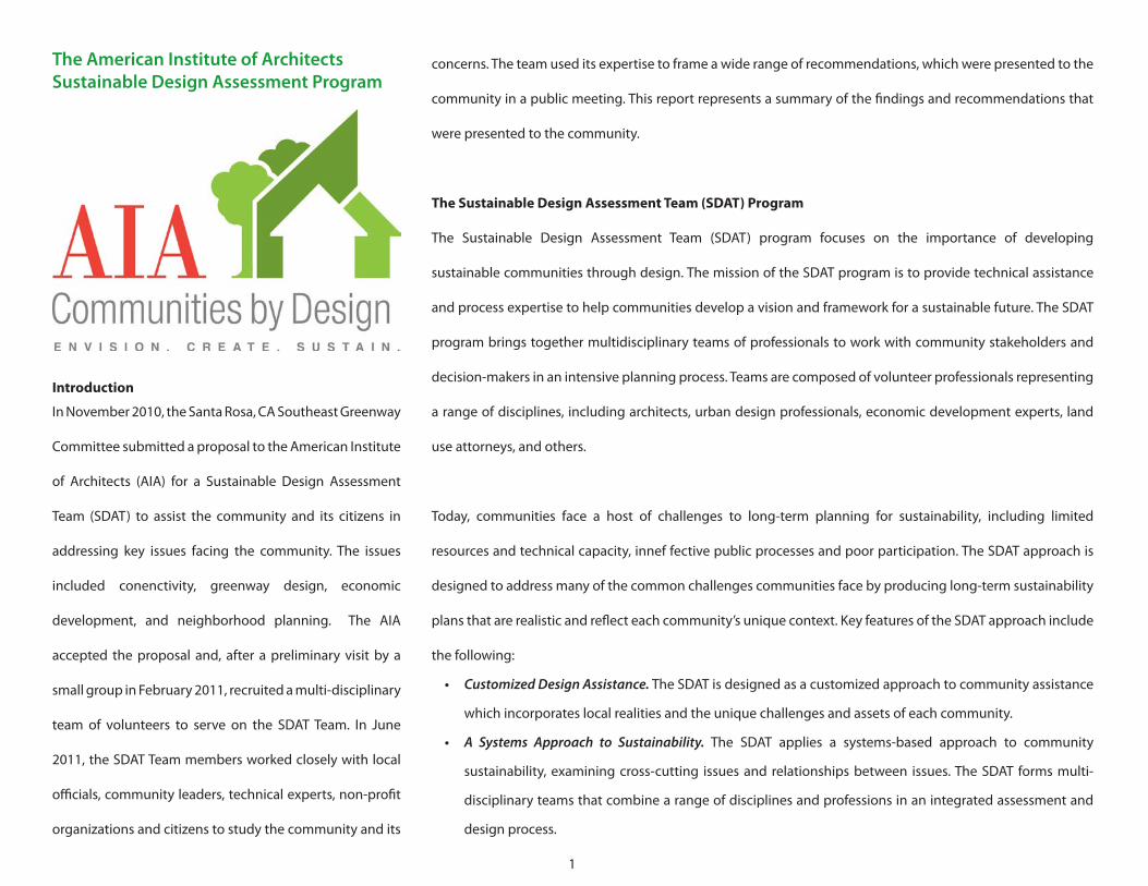
The American Institute of Architects Sustainable Design Assessment Program
Introduction
In November 2010, the Santa Rosa, CA Southeast Greenway
Committee submitted a proposal to the American Institute
of Architects (AIA) for a Sustainable Design Assessment
Team (SDAT) to assist the community and its citizens in
addressing key issues facing the community. The issues
included conenctivity, greenway design, economic
development, and neighborhood planning. The AIA
accepted the proposal and, after a preliminary visit by a
small group in February 2011, recruited a multi-disciplinary
team of volunteers to serve on the SDAT Team. In June
2011, the SDAT Team members worked closely with local
officials, community leaders, technical experts, non-profit
organizations and citizens to study the community and its
concerns. The team used its expertise to frame a wide range of recommendations, which were presented to the
community in a public meeting. This report represents a summary of the findings and recommendations that
were presented to the community.
The Sustainable Design Assessment Team (SDAT) Program
The Sustainable Design Assessment Team (SDAT) program focuses on the importance of developing
sustainable communities through design. The mission of the SDAT program is to provide technical assistance
and process expertise to help communities develop a vision and framework for a sustainable future. The SDAT
program brings together multidisciplinary teams of professionals to work with community stakeholders and
decision-makers in an intensive planning process. Teams are composed of volunteer professionals representing
a range of disciplines, including architects, urban design professionals, economic development experts, land
use attorneys, and others.
Today, communities face a host of challenges to long-term planning for sustainability, including limited
resources and technical capacity, innef fective public processes and poor participation. The SDAT approach is
designed to address many of the common challenges communities face by producing long-term sustainability
plans that are realistic and reflect each community’s unique context. Key features of the SDAT approach include
the following:
• Customized Design Assistance. The SDAT is designed as a customized approach to community assistance
which incorporates local realities and the unique challenges and assets of each community.
• A Systems Approach to Sustainability. The SDAT applies a systems-based approach to community
sustainability, examining cross-cutting issues and relationships between issues. The SDAT forms multi-
disciplinary teams that combine a range of disciplines and professions in an integrated assessment and
design process.
2
• Inclusive and Participatory Processes.
Public participation is the foundation
of good community design. The SDAT
involves a wide range of stakeholders and
utilizes short feedback loops, resulting
in sustainable decision-making that has
broad public support and ownership.
• Objective Technical Expertise. The SDAT
Team is assembled to include a range of
technical experts from across the country.
Team Members do not accept payment
for services in an SDAT. They serve in a
volunteer capacity on behalf of the AIA
and the partner community. As a result,
the SDAT Team has enhanced credibility
with local stakeholders and can provide
unencumbered technical advice.
• CostEffectiveness.By employing the SDAT
approach, communities are able to take
advantage of leveraged resources for their
planning efforts. The AIA contributes up
to $15,000 in financial assistance for each
project. The SDAT team members volunteer
their labor and expertise, allowing
communities to gain immediate access to
the combined technical knowledge of top-
notch professionals from varied fields.
The SDAT program is modeled on the Regional and Urban Design Assistance Team
(R/UDAT) program, one of AIA’s longest-running success stories. While the R/UDAT
program was developed to provide communities with specific design solutions, the
SDAT program provides broad assessments to help frame future policies or design
solutions in the context of sustainability and help communities plan the first steps
of implementation. Through the Design Assistance Team (DAT) program, over 500
professionals from 30 disciplines have provided millions of dollars in professional pro
bono services to more than 190 communities across the country. The SDAT program
leverages the pivotal role of the architectural community in the creation and support
of sustainable livable communities.
The following report includes a narrative account of the Southeast Greenway SDAT
project recommendations, with summary information concerning several principle
areas of investigation. The recommendations are made within the broad framework of
sustainability, and are designed to form an integrated approach to future sustainability
efforts in the community.

BACKGROUND, PROCESS & EXECUTIVE SUMMARY
4
The Highway 12 freeway remains on Caltrans books as a future transportation project, but is not moving forward.
Realistically, no Highway 12 freeway will ever be built on this corridor. The project would be phenomenally
expensive, have devastating environmental and community impacts, would not significantly relieve congestion,
and would promote sprawl. Traffic problems on the surface Highway 12 corridor are better dealt with by improving
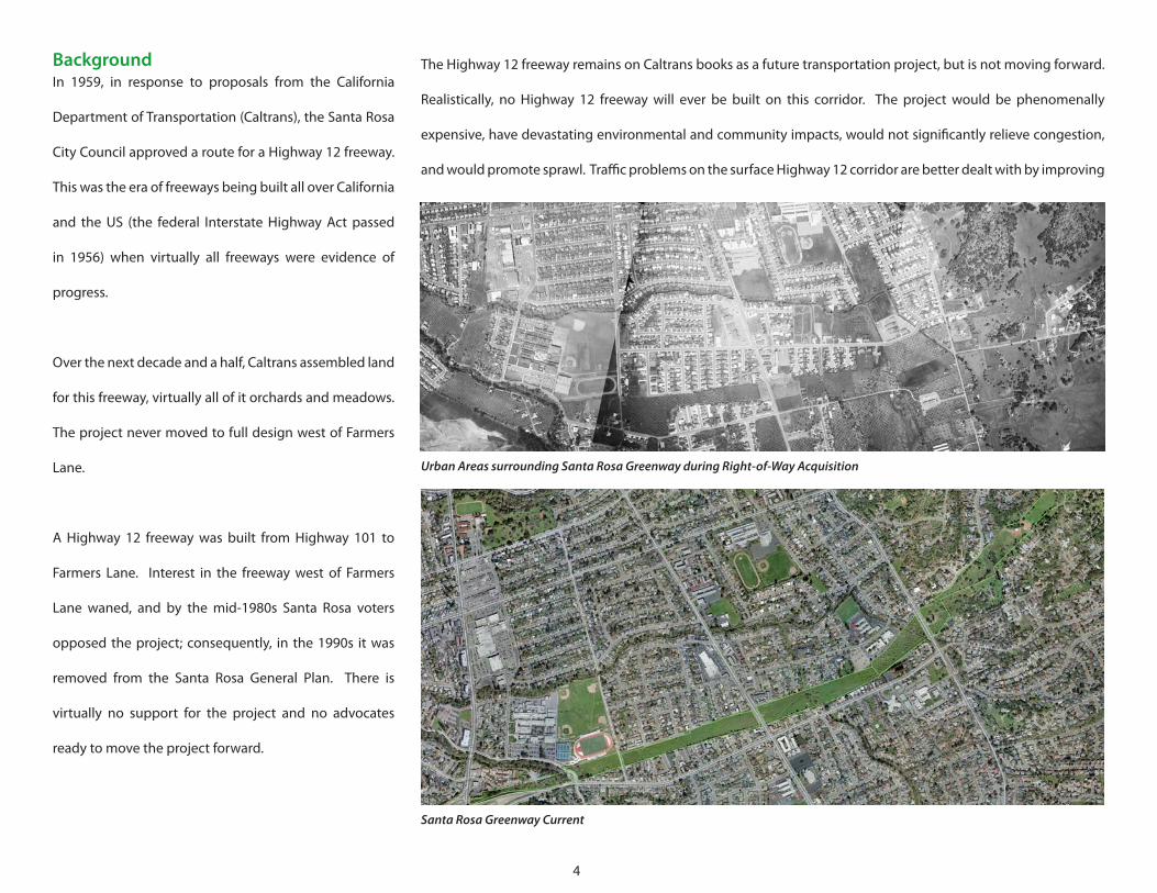
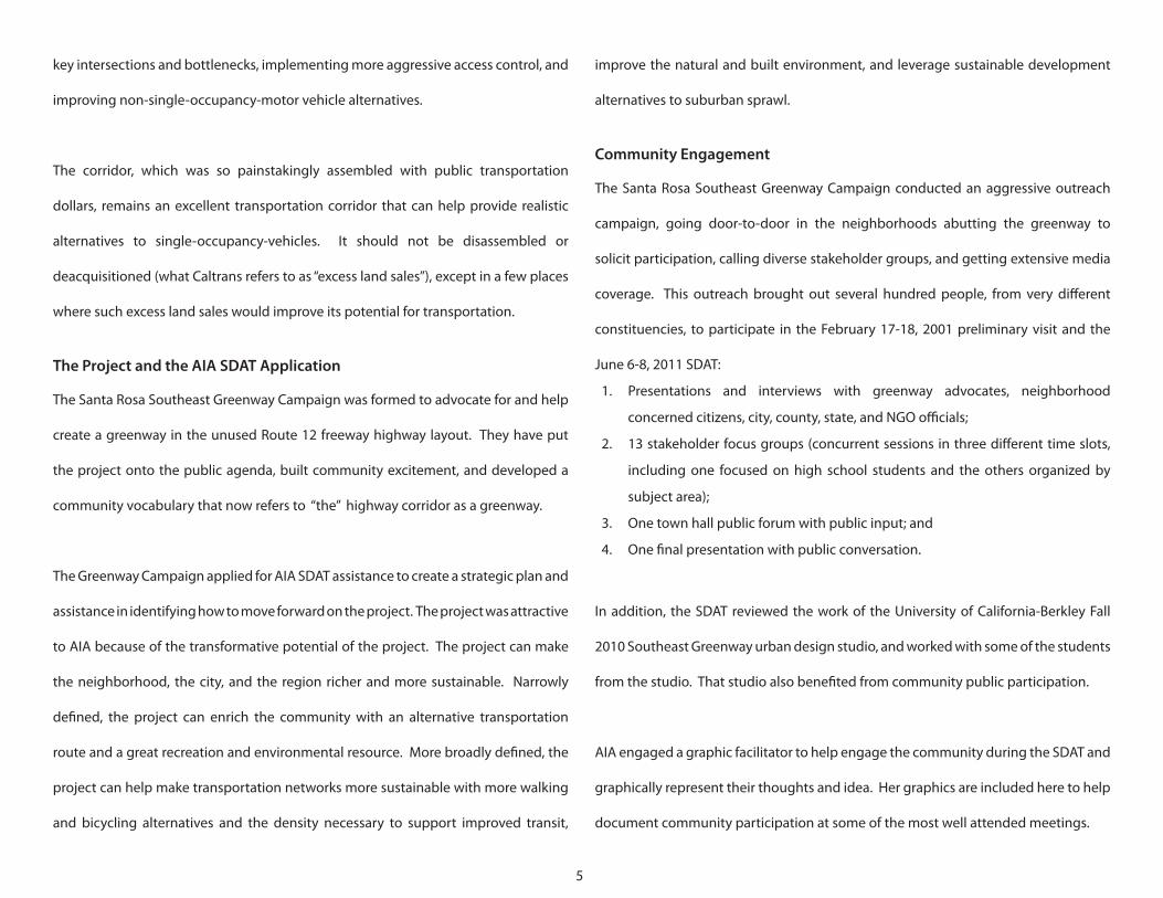
BackgroundIn 1959, in response to proposals from the California
Department of Transportation (Caltrans), the Santa Rosa
City Council approved a route for a Highway 12 freeway.
This was the era of freeways being built all over California
and the US (the federal Interstate Highway Act passed
in 1956) when virtually all freeways were evidence of
progress.
Over the next decade and a half, Caltrans assembled land
for this freeway, virtually all of it orchards and meadows.
The project never moved to full design west of Farmers
Lane.
A Highway 12 freeway was built from Highway 101 to
Farmers Lane. Interest in the freeway west of Farmers
Lane waned, and by the mid-1980s Santa Rosa voters
opposed the project; consequently, in the 1990s it was
removed from the Santa Rosa General Plan. There is
virtually no support for the project and no advocates
ready to move the project forward.
UrbanAreassurroundingSantaRosaGreenwayduringRight-of-WayAcquisition
SantaRosaGreenwayCurrent
5
key intersections and bottlenecks, implementing more aggressive access control, and
improving non-single-occupancy-motor vehicle alternatives.
The corridor, which was so painstakingly assembled with public transportation
dollars, remains an excellent transportation corridor that can help provide realistic
alternatives to single-occupancy-vehicles. It should not be disassembled or
deacquisitioned (what Caltrans refers to as “excess land sales”), except in a few places
where such excess land sales would improve its potential for transportation.
The Project and the AIA SDAT Application
The Santa Rosa Southeast Greenway Campaign was formed to advocate for and help
create a greenway in the unused Route 12 freeway highway layout. They have put
the project onto the public agenda, built community excitement, and developed a
community vocabulary that now refers to “the” highway corridor as a greenway.
The Greenway Campaign applied for AIA SDAT assistance to create a strategic plan and
assistance in identifying how to move forward on the project. The project was attractive
to AIA because of the transformative potential of the project. The project can make
the neighborhood, the city, and the region richer and more sustainable. Narrowly
defined, the project can enrich the community with an alternative transportation
route and a great recreation and environmental resource. More broadly defined, the
project can help make transportation networks more sustainable with more walking
and bicycling alternatives and the density necessary to support improved transit,
improve the natural and built environment, and leverage sustainable development
alternatives to suburban sprawl.
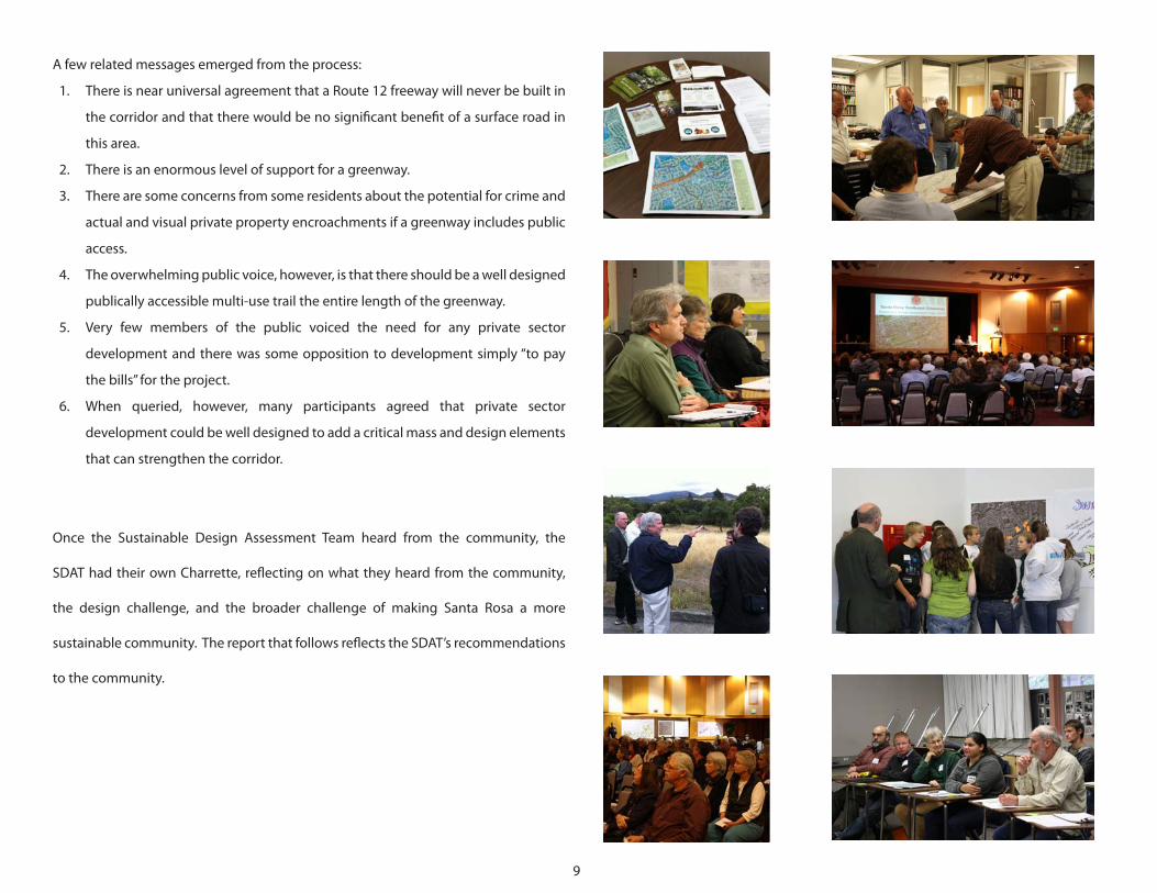
Community Engagement
The Santa Rosa Southeast Greenway Campaign conducted an aggressive outreach
campaign, going door-to-door in the neighborhoods abutting the greenway to
solicit participation, calling diverse stakeholder groups, and getting extensive media
coverage. This outreach brought out several hundred people, from very different
constituencies, to participate in the February 17-18, 2001 preliminary visit and the
June 6-8, 2011 SDAT:
1. Presentations and interviews with greenway advocates, neighborhood
concerned citizens, city, county, state, and NGO officials;
2. 13 stakeholder focus groups (concurrent sessions in three different time slots,
including one focused on high school students and the others organized by
subject area);
3. One town hall public forum with public input; and
4. One final presentation with public conversation.
In addition, the SDAT reviewed the work of the University of California-Berkley Fall
2010 Southeast Greenway urban design studio, and worked with some of the students
from the studio. That studio also benefited from community public participation.
AIA engaged a graphic facilitator to help engage the community during the SDAT and
graphically represent their thoughts and idea. Her graphics are included here to help
document community participation at some of the most well attended meetings.
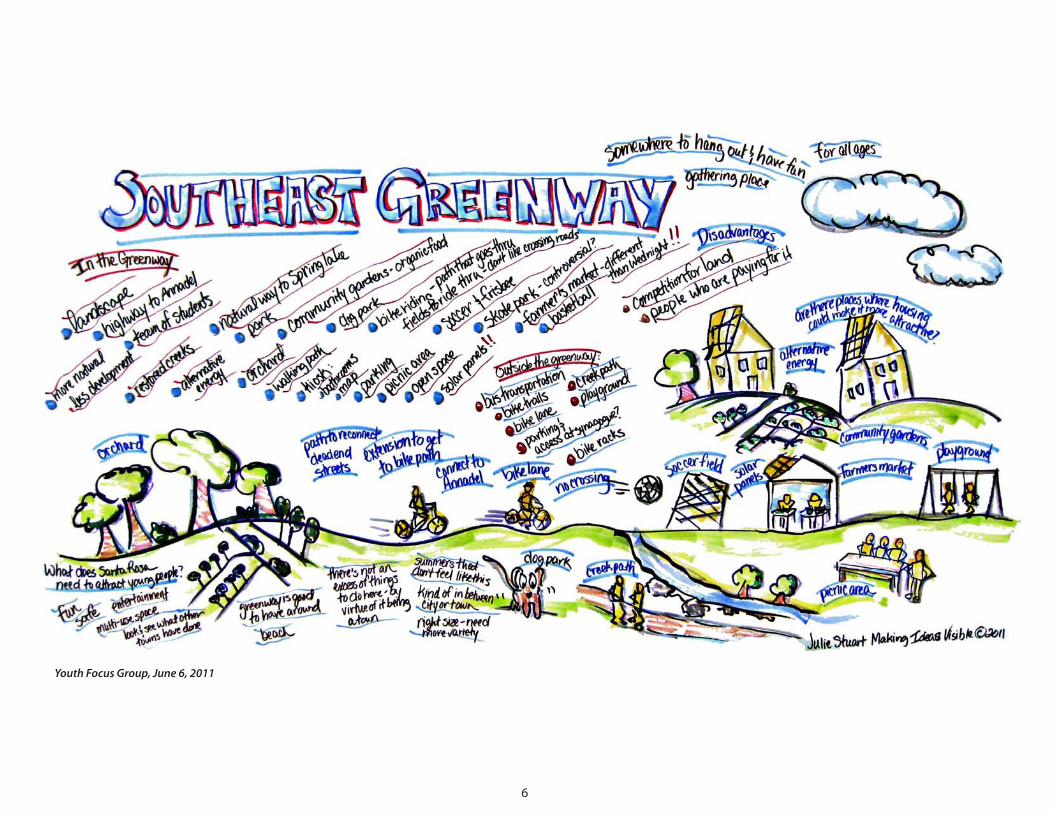
6
YouthFocusGroup,June6,2011
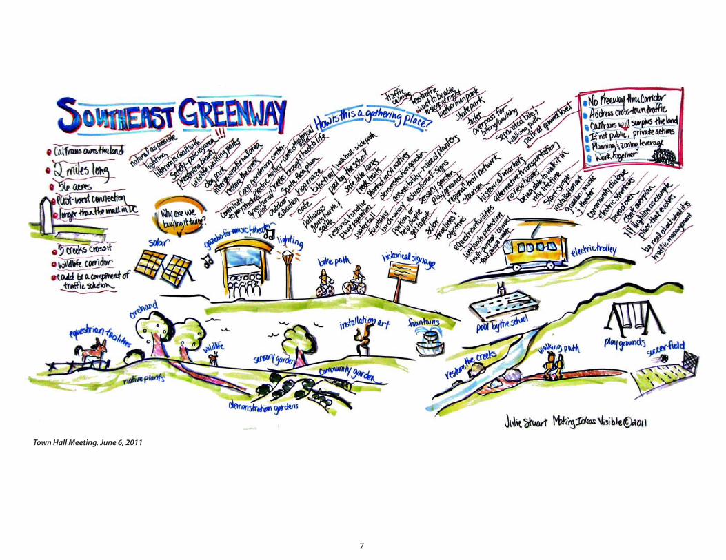
7
TownHallMeeting,June6,2011
8
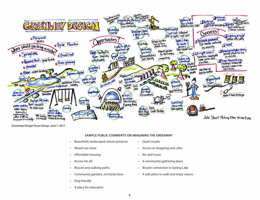
• Quiet respite
• Access to shopping and cafes
• Art and music
• A community gathering place
• Bicycle connection to Spring Lake
• A safe place to walk and enjoy nature
• Beautifully landscaped nature preserve
• Mixed-use areas
• Affordable housing
• Access for all!
• Bicycle and walking paths
• Community gardens, orchards/trees
• Dog friendly
• A place for education
SAMPLE PUBLIC COMMENTS ON IMAGINING THE GREENWAY
GreenwayDesignFocusGroup,June7,2011
9
A few related messages emerged from the process:
1. There is near universal agreement that a Route 12 freeway will never be built in
the corridor and that there would be no significant benefit of a surface road in
this area.
2. There is an enormous level of support for a greenway.
3. There are some concerns from some residents about the potential for crime and
actual and visual private property encroachments if a greenway includes public
access.
4. The overwhelming public voice, however, is that there should be a well designed
publically accessible multi-use trail the entire length of the greenway.
5. Very few members of the public voiced the need for any private sector
development and there was some opposition to development simply “to pay
the bills” for the project.
6. When queried, however, many participants agreed that private sector
development could be well designed to add a critical mass and design elements
that can strengthen the corridor.
Once the Sustainable Design Assessment Team heard from the community, the
SDAT had their own Charrette, reflecting on what they heard from the community,
the design challenge, and the broader challenge of making Santa Rosa a more
sustainable community. The report that follows reflects the SDAT’s recommendations
to the community.
10
GREENWAY ECOSYSTEM: GREENWAY AS A PARK AND GATHERING PLACE
If the spine of the greenway is a multiuse trail network, the flesh is the greenway
adjacent to the trails. That is what will make the greenway a rich and sustainable
experience and a gathering place for people of all ages. The greenway should build
a critical mass of users and a gathering place for diverse populations from different
neighborhoods, age groups, and backgrounds. Second, the greenway should create a
healthy, walkable, environmentally friendly environment that both invites the public
and educates them about their environment.
SERVE THE REGION, CITY, AND NEIGHBORHOOD: GREENWAY AS A REGIONAL RESOURCE
The greenway can and should serve multiple publics in the region, the city, and the
neighborhood all at once.
• A neighborhood local gathering place and a pedestrian scale area. Neighborhood
residents will be the prime beneficiary of the chance to walk their dogs, stroll to
breakfast, chat with their neighbors, and see their real estate values escalate
significantly.
• A city regional park and transportation network. Citywide, everyone will benefit
from a new regional park, a safe opportunity to bicycle from downtown Santa
Rosa to Spring Lake, a new vibrant village in Santa Rosa, and a more sustainable
development pattern.
• A regional identity. The entire region will benefit from connecting the future
SMART multi-use trail, downtown Santa Rosa, Spring Lake, and eventually
Sonoma with a non-motorized trail. More significantly, the region will benefit
as Santa Rosa’s reputation as an outdoor hub and a great place to visit and play
grows.
Executive SummaryStarting five decades ago, the California Department of Transportation acquired two
miles of right-of-way for a freeway project (Route 12) that will never be built. The
right-of-way is not needed for a highway and it is not needed for a surface road
This painstaking work created a transportation corridor that can now host a
non-motorized transportation route and a greenway that can move people, enhance
the environment, leverage economic development activity, promote social equity,
and generally improve the quality of life within Santa Rosa. The AIA SDAT identified
seven issues that cut across all aspects of the project.
MULTIUSE TRAIL: GREENWAY AS A TRANSPORTATION CORRIDOR
The freeway is dead, but the corridor will reign forever as a transportation corridor.
The vast majority of this corridor should remain a transportation corridor dedicated
to moving people where they want to go. Instead of a highway, a road primarily
designed to move people in single-occupancy vehicles, the spine of the corridor
should be a non-motorized multi-use trail network. There are already sufficient roads
in Santa Rosa to move freight and vehicles (although some improvements are certainly
needed for those roads), but often trails can move people more efficiently, with lower
cost and environmental harm, and in a more healthy lifestyle. Transportation systems
should allow a choice of modes, and in southeastern Santa Rosa the mode that is
most underserved presently is non-motorized transport.
11
plan already, all that is needed is to amend the plan from Newanga and Hoen Avenue
(on the south) to the northerly limits of the Caltrans right-of-way, extending westerly
to include the entire Highway 12/Farmers Avenue cloverleaf.
Since “the perfect is the enemy of the good,” a white paper, planning all of the
steps to implement the southeast greenway and strategic plans and transportation
engineering should proceed in support of the eventual general plan update. All of
the planning should be as collaborative and consensus building as possible.
LET THE PLAN DRIVE THE PROCESS: GREENWAY AS A GOVERNING PRINCIPLE
The strategic and eventual general plan should drive the process, with the eye always
on the greenway and the related economic development. Caltrans is a vital partner
interested in all aspects of the project:
• The multi-use trail and greenway is a transportation system that Caltrans should
hold.
• If Caltrans ever wants to excess the greenway, the City or Sonoma Open Space
District should buy it at very low cost since planning and zoning will not allow
other uses.
• Caltrans will get a significant financial return when they sell the identified
parcels for economic development, once City planning and zoning are in place.
• Caltrans needs the partnership as much as the city does. They will receive more
revenue working with the city under the recommended scenario than if they
sold their property now with no plan or zoning in place.
SUSTAINABLE DEVELOPMENT: GREENWAY AS ECONOMIC DEVELOPMENT
The greenway will add value to surrounding properties (who doesn’t want to live,
work and play next to a great park). In doing so, it will stimulate additional investment
in existing developed properties adjacent and near the greenway.
Equally exciting, there are some critical new economic development opportunities
in a couple of areas in the former freeway right-of-way that will add a focus for the
greenway, produce jobs, increase tax revenue, and create a node with enough density
that transit can become more viable.
ADJACENT HIGHWAY 12: GREENWAY AS SURFACE ROADWAY IMPROVEMENT
The intersection of the greenway, Highway 12, and Farmers Lane can be reconfigured
to significantly improve its traffic flow, removing a significant bottleneck on Route
12. The freeway was designed to bridge Farmers Lane with Farmers Lane being but
an exit. Finally acknowledging that Farmers Lane is the permanent host for Route
12 allows this intersection to be reconfigured by dropping the pretense of a freeway
extension and optimizing this connection. This will improve surface transportation,
create one of the economic development opportunities at this newly configured
intersection, and create a node that defines the start of the greenway.
PLAN WITH THE COMMUNITY: GREENWAY AS A COLLABORATIVE PROCESS
The Santa Rosa general plan, which currently does not address the greenway site, will
need to be amended to include the site. Given that Santa Rosa has a good general
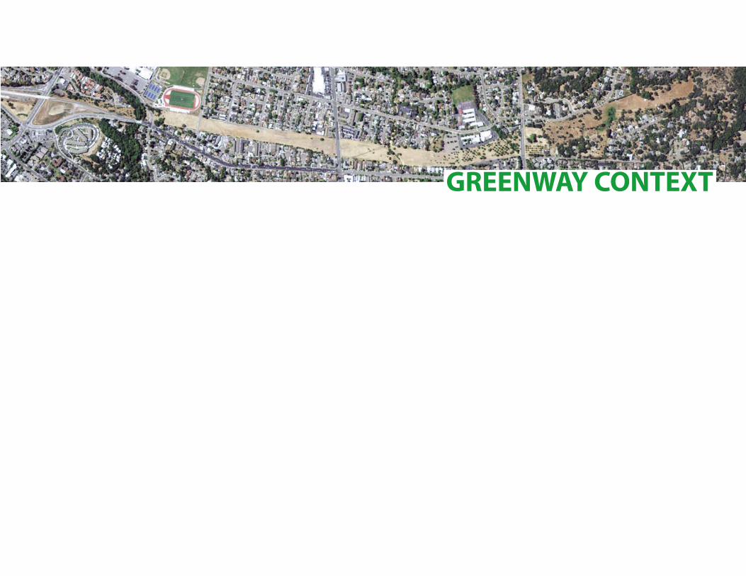
GREENWAY CONTEXT
13
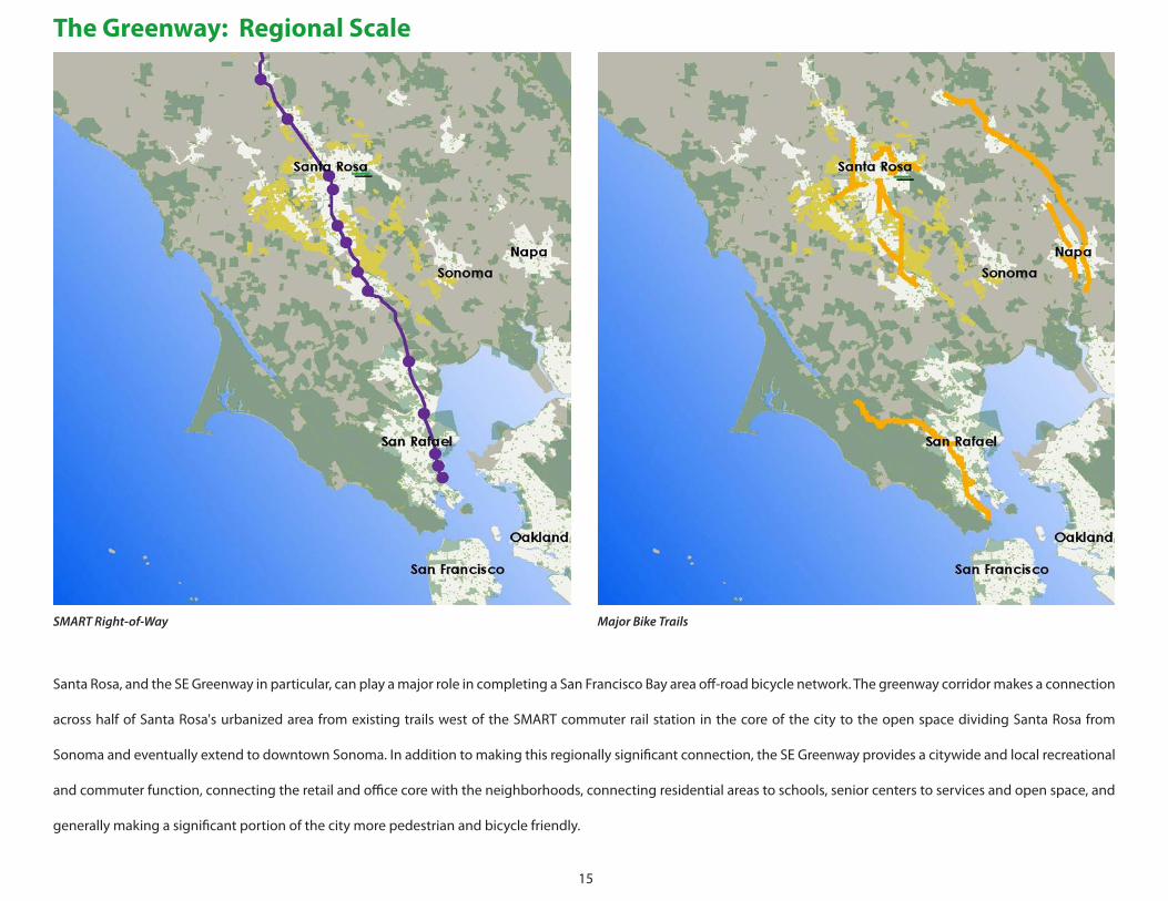
Santa Rosa commuter rail station will be less than two miles from the western end
of the Greenway, linked directly by the last completed highway leg of Route 12. If
bus, shuttle and bikeway connections can be established along the greenway and
to the rail station, the neighborhoods of southeast Santa Rosa can participate in the
advantages of regional access.
Bikeways and bike lanes already thread the region, and continuous trail systems
connecting major destinations and recreational destinations are either in place or
planned; the Greenway Corridor is a potential strong link in these networks, as well.
Regional east/west volumes of traffic along the Route 12 Corridor may not expand
substantially in the future for several reasons, including restrictions on development
posed by the urban growth boundaries to the east. This observation suggests that
the regional demand for street and highway capacity might be managed along
the existing Route 12 corridor with reasonable improvements, so that regional “cut
through” traffic may not envelope the neighborhoods along the Greenway.
Regional planning will also ensure that Santa Rosa remains the center of a diverse
agricultural region. The SDAT planning team suggests that the Greenway could
celebrate the agriculture of the region, drawing representative plots, crops and groves
into the landscaping themes.
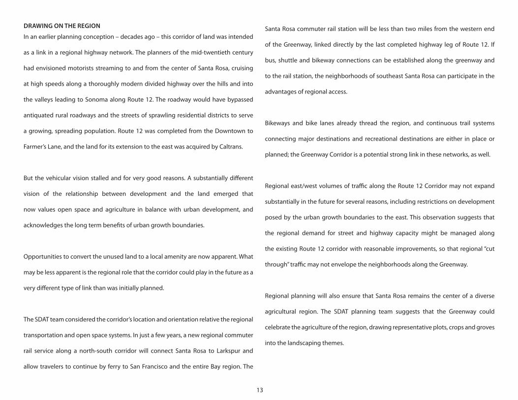
DRAWING ON THE REGION
In an earlier planning conception – decades ago – this corridor of land was intended
as a link in a regional highway network. The planners of the mid-twentieth century
had envisioned motorists streaming to and from the center of Santa Rosa, cruising
at high speeds along a thoroughly modern divided highway over the hills and into
the valleys leading to Sonoma along Route 12. The roadway would have bypassed
antiquated rural roadways and the streets of sprawling residential districts to serve
a growing, spreading population. Route 12 was completed from the Downtown to
Farmer’s Lane, and the land for its extension to the east was acquired by Caltrans.
But the vehicular vision stalled and for very good reasons. A substantially different
vision of the relationship between development and the land emerged that
now values open space and agriculture in balance with urban development, and
acknowledges the long term benefits of urban growth boundaries.
Opportunities to convert the unused land to a local amenity are now apparent. What
may be less apparent is the regional role that the corridor could play in the future as a
very different type of link than was initially planned.
The SDAT team considered the corridor’s location and orientation relative the regional
transportation and open space systems. In just a few years, a new regional commuter
rail service along a north-south corridor will connect Santa Rosa to Larkspur and
allow travelers to continue by ferry to San Francisco and the entire Bay region. The
14
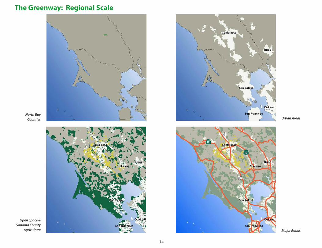
The Greenway: Regional Scale
NorthBayCounties UrbanAreas
OpenSpace&SonomaCounty
Agriculture MajorRoads
15
SMARTRight-of-Way MajorBikeTrails
The Greenway: Regional Scale
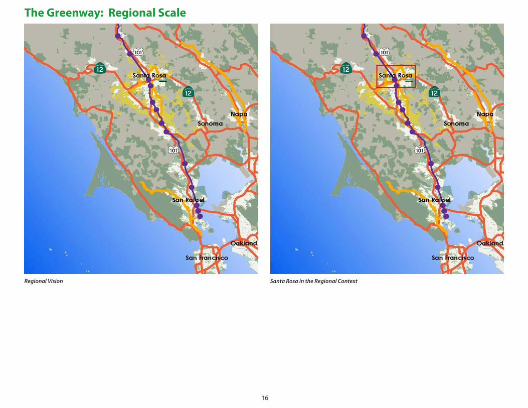
Santa Rosa, and the SE Greenway in particular, can play a major role in completing a San Francisco Bay area off-road bicycle network. The greenway corridor makes a connection
across half of Santa Rosa's urbanized area from existing trails west of the SMART commuter rail station in the core of the city to the open space dividing Santa Rosa from
Sonoma and eventually extend to downtown Sonoma. In addition to making this regionally significant connection, the SE Greenway provides a citywide and local recreational
and commuter function, connecting the retail and office core with the neighborhoods, connecting residential areas to schools, senior centers to services and open space, and
generally making a significant portion of the city more pedestrian and bicycle friendly.
16
RegionalVision SantaRosaintheRegionalContext
The Greenway: Regional Scale
17
But at its eastern end, the corridor abruptly rises
through oak-spotted hills, threading a path
towards triple-park open space. Spring Lake Park,
Howarth Park and the expansive Annadel State
Park form an open space network of extraordinary
recreational and environmental value, adjacent to
the neighborhoods in the valleys below. Standing
at nearly any point in the Greenway, the view of the
hills draws the eye and the imagination.
Over time, the Downtown will be the focus of a
more urban scale, transit-oriented development
at the crossroads of the major rail, bus, highway,
arterials, bikeways and path networks. Future
compact development of the Downtown will
also benefit from the City’s economic and Smart
Growth initiatives. The Greenway presents a rare
opportunity to create a highly imageable linear
transition: Urban Downtown to highway, highway
to Greenway and its flanking neighborhoods, and
finally Greenway to the parks and eventually to
Sonoma.
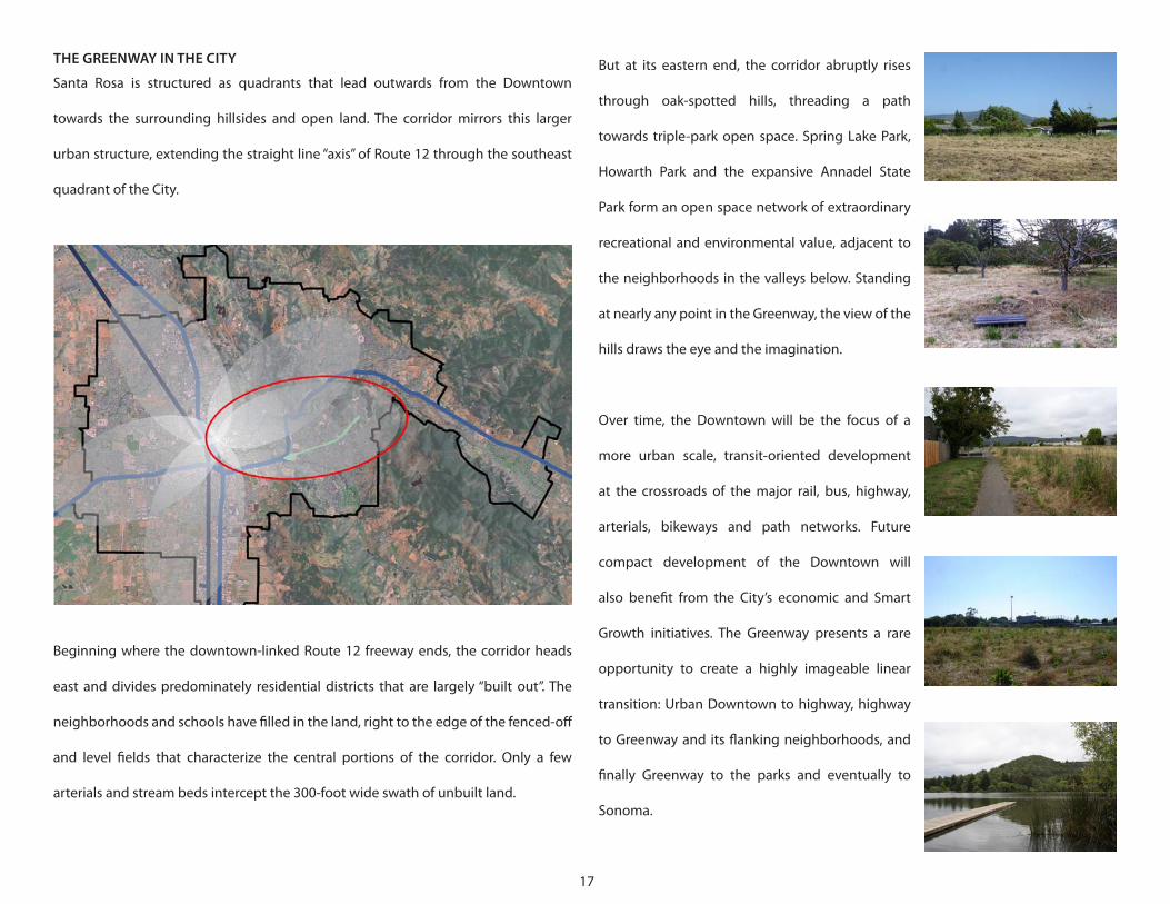
THE GREENWAY IN THE CITY
Santa Rosa is structured as quadrants that lead outwards from the Downtown
towards the surrounding hillsides and open land. The corridor mirrors this larger
urban structure, extending the straight line “axis” of Route 12 through the southeast
quadrant of the City.
Beginning where the downtown-linked Route 12 freeway ends, the corridor heads
east and divides predominately residential districts that are largely “built out”. The
neighborhoods and schools have filled in the land, right to the edge of the fenced-off
and level fields that characterize the central portions of the corridor. Only a few
arterials and stream beds intercept the 300-foot wide swath of unbuilt land.
18
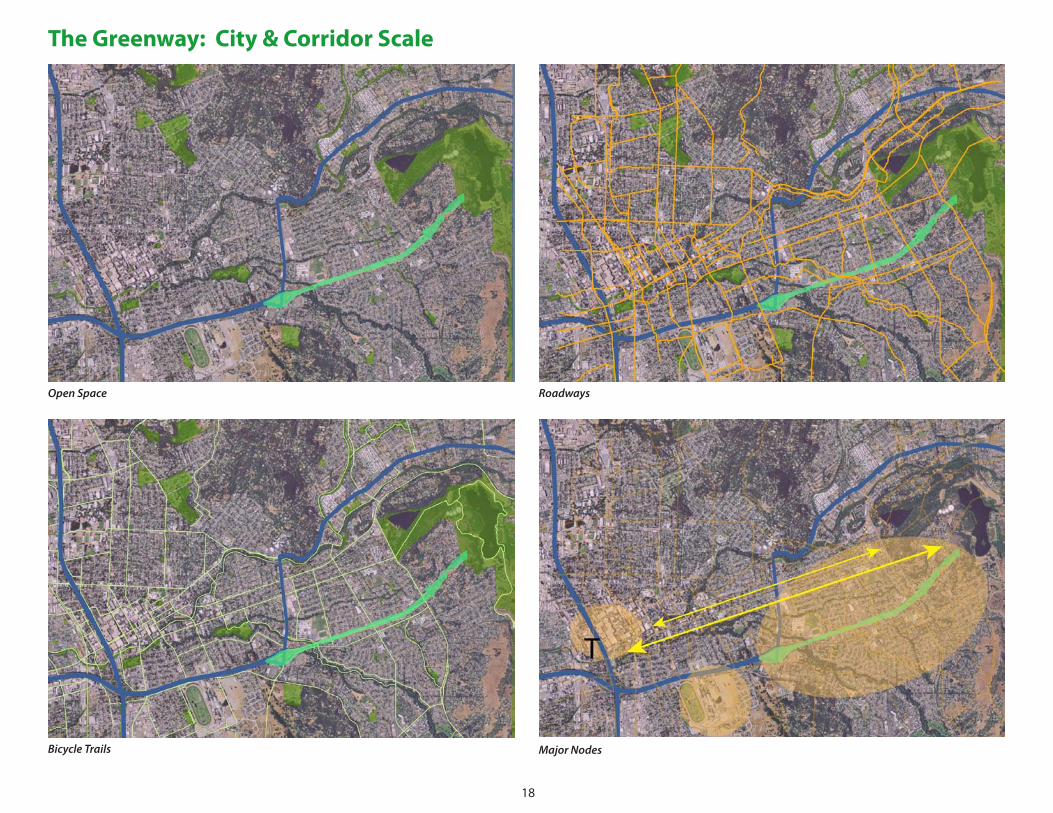
The Greenway: City & Corridor Scale
OpenSpace Roadways
BicycleTrails MajorNodes
19
OpenSpace,theGreenway,&MajorRoads Transit
BikeRoutes Schools
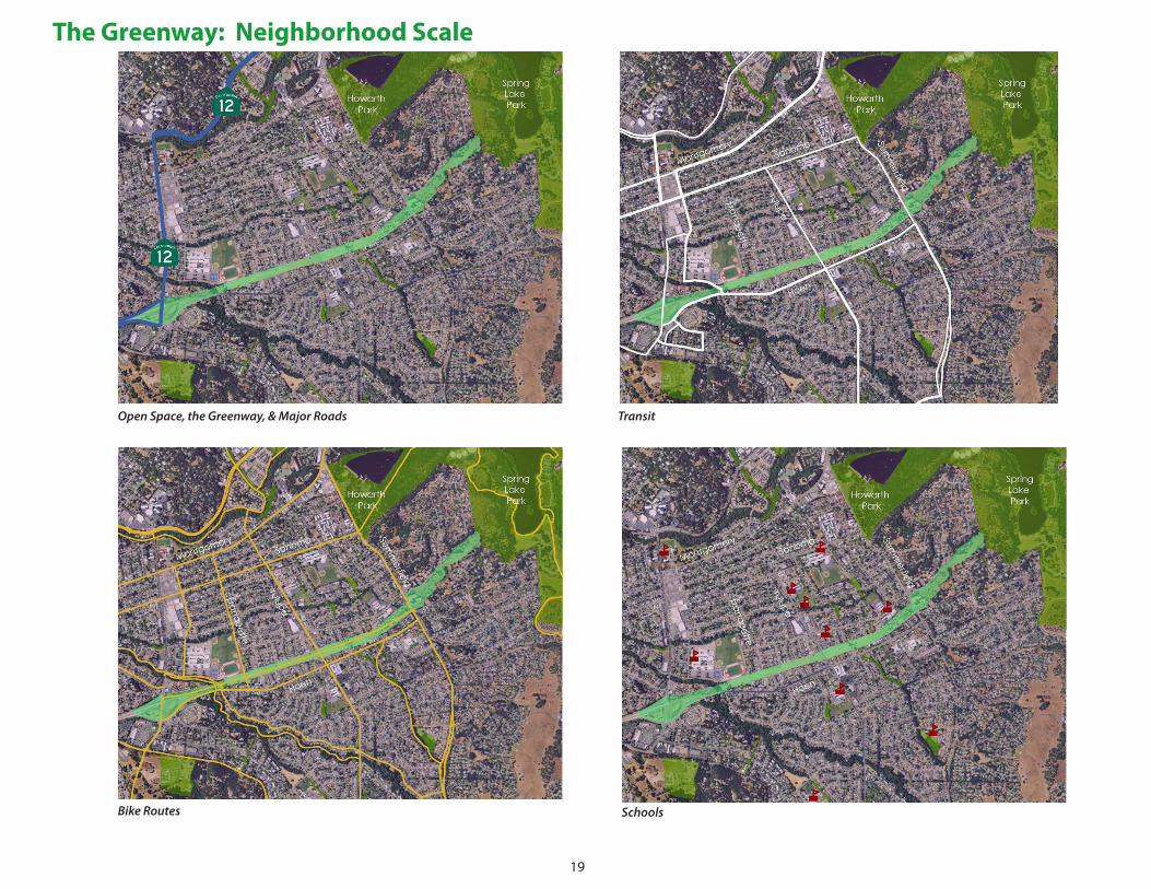
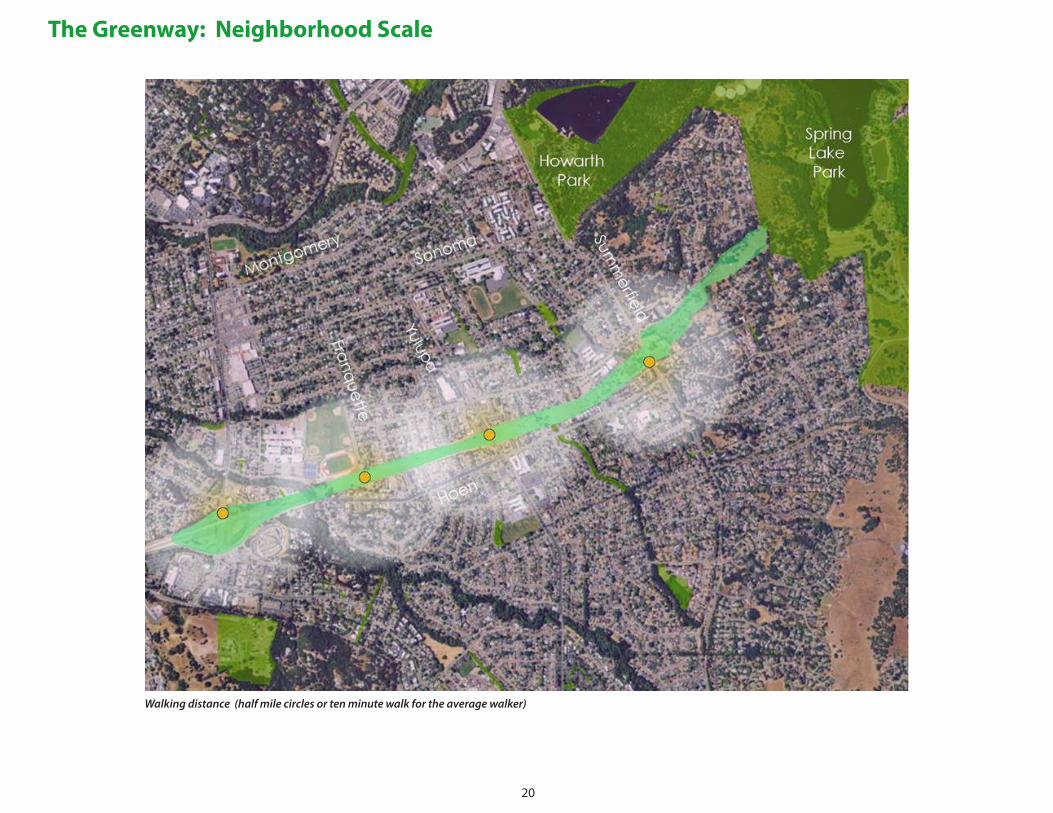
The Greenway: Neighborhood Scale
20
Walkingdistance(halfmilecirclesortenminutewalkfortheaveragewalker)
The Greenway: Neighborhood Scale
21
should be judiciously used as a visual amenity, drawing the eye but guarding its use
as an irrigation resource. This approach recognizes the special fascination associated
with even a small pool, fountain or flume of water. As part of a re-engineered storm
water system, the potential for underground cisterns might be explored. Peak season
overflows might be stored and brought back to the surface for irrigation with small
wind-driven pumps or other devices to keep the Greenway green.
Connections along the Greenway – The Greenway should create continuous
pedestrian and bicycle paths along its entire length. Where appropriate, these paths
should be separated; in other locations, they might be advantageously combined.
In every location, the pathways should be interesting and provide a varied visual
experience. As envisioned by the team, a winding bicycle route would extend along
the entire length. Walkways might be generally located along the perimeter, providing
relatively straight paths between the Greenway segments and leaving the interior
areas for the variety of uses and features imagined for the future.
Connections across the Greenway – The redesign of the Greenway can connect
severed sidewalks and pathways between the northern and southern neighborhoods
that flank the corridor. In many locations, rights-of-way already exist or might be
obtained as easements so that residents and visitors experience the Greenway as a
landscaped interlude along a walk between destinations, rather than as a barrier.
THE BIG PICTURE: IDEAS TO SHAPE THE CORRIDOR
“Urban design” is the composition of large scale places to create an effective and
meaningful fabric that combines landscape, development and infrastructure. The
SDAT team considered the urban design of the Greenway and of adjacent areas at
the same time. In this regard, it is very important to understand the transformative
opportunities presented by the Greenway on nearby areas. Borders can be turned
into seams and barriers into connections if the corridor is considered within a broader
framework of community design. A number of overall concepts emerged for the
urban design of the corridor from the community discussions and intensive working
sessions among the team members, participating students and community members.
The Greenway as Oasis – The Greenway has been envisioned as a type of oasis that
provides an abundant and flourishing landscape along its entire length. This oasis is
intended to be a contrast to the urban neighborhoods that border it. Although the
oasis may be punctuated with special buildings and facilities in focused locations, its
landscaping should be steps away from any location.
Water – An oasis is fed by water, and the greenway will be no exception. The team
imagined the opportunities associated with re-engineering the seasonal and
permanent water flows, restoring as much of it back to the surface from underground
culverts and pipes as possible. The water should function as both an environmental
and agricultural resource that can allow restoration of habitats, creative approaches
to using and dispersing water during peak seasons and peak rain events. The water
22
or place to pause along the Greenway where neighbors could meet. Perhaps the
concept of an active streetscape and commercial uses could extend along the blocks
of Yulupa north and south of the Greenway, adding to the activity and amenities that
a Main Street environment provides for villages and towns.
Different Ends – The two ends of the corridor are very different; they should be
planned with quite different visions in mind. The east end should merge with the
natural, native landscape and the picturesque parks atop the hills. At the west end,
the team noted that the land has been organized along the lines of a highway
interchange that will never be needed, with large infields created by the diamond
pattern of on- and off-ramps. If the interchange remnants were re-organized to create
more straightforward alignments and intersections, an enormous amount of useable,
accessible land can be made available. This could be the “urban” end of the corridor,
absorbing a mix of residential, commercial and retail uses to serve the neighborhoods
and take advantage of the direct, express connections to the downtown. This could
become a node for shuttle to the city center and the rail station. It could also provide a
parking area for visitors to the Greenway, who could bring their bicycle or pedestrian
journeys along the paths to the amenities and parks to the east.
Edges as Seams – The edges of the corridor currently act as effective barriers to usage.
Reconsidered, the edges should become seams that provide access and amenities
directly associated with the uses that line them. Open spaces near the schools can add
recreational and educational opportunities. Walkways from neighborhoods might
Urban Agriculture as Civic Amenity and Distinctive Identity – The SDAT team’s
vision suggests that urban agriculture can serve as a dominant and distinctive and
meaningful landscape character along substantial portions of the corridor. Several
inspirations converged to form this concept. Fundamentally, the climate of Santa
Rosa corridor provides a magnificent horticultural and agricultural opportunity,
particularly if irrigation can be employed. There are related historic and cultural roots
here: Santa Rosa’s legacy includes Luther Burbank’s innovative horticulture and the
cultivars he pioneered. Santa Rosa is set within a region of astonishing vineyards and
other valued crops; the landscaping of the Greenway could reflect this agricultural
context. There is a direct legacy on site. The deteriorated groves of walnut trees at
the eastern end of the corridor might be restored, for example. Groves of other nut
and fruit trees might create formal arrays of trees that are attractive and tasty. Finally,
urban community gardening represents sustainable civic activity that brings many
benefits. Innovative programs to expand community gardening could find their way
to irrigated plots.
A Center at the Center – The team considered the strengths of the neighborhoods
surrounding the Greenway, and noted a lack of traditional civic centers that create
informal gathering places and a sense of identity. The area where Yulupa Avenue
crosses the Greenway seems to be a “center of gravity” that joins the neighborhoods
on both sides. If small shops, cafés and civic uses could be assembled within the
greenway at this crossing, a new neighborhood center would emerge that could be
reached by bicycles, sidewalks and paths from all directions, and be a destination
23
lead to community gardens. Street segments
might provide parking that does not disturb
either the park or the neighborhood. Over time,
the buildings along the Greenway’s edge can be
expected to increase in value and renovations
will be undertaken to re-orient doors, decks,
windows and porches that face the park and
populate its edges. Nearby, underutilized
parcels like the former medical complex near
Summerfield and Hoen Avenues might be
beneficially redeveloped with uses that can
take advantage of the nearby Greenway as an
amenity and its connections to a much broader
area. Eventually, the Greenway will become a
welcome front door for the community, rather
than the unusable backyard it has been for
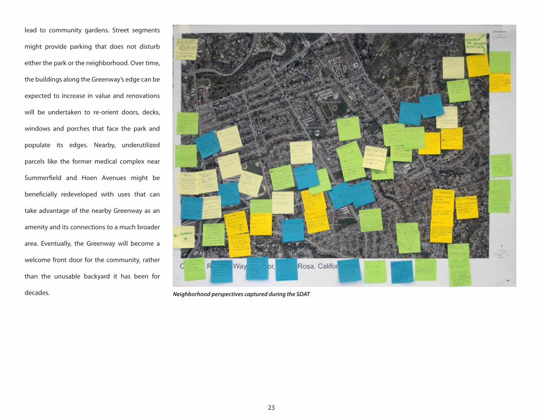
decades. NeighborhoodperspectivescapturedduringtheSDAT
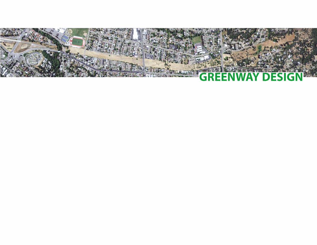
GREENWAY DESIGN
25
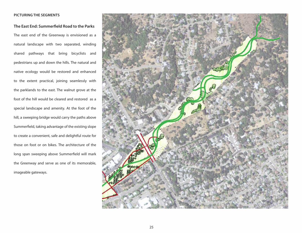
PICTURING THE SEGMENTS
The East End: Summerfield Road to the Parks
The east end of the Greenway is envisioned as a
natural landscape with two separated, winding
shared pathways that bring bicyclists and
pedestrians up and down the hills. The natural and
native ecology would be restored and enhanced
to the extent practical, joining seamlessly with
the parklands to the east. The walnut grove at the
foot of the hill would be cleared and restored as a
special landscape and amenity. At the foot of the
hill, a sweeping bridge would carry the paths above
Summerfield, taking advantage of the existing slope
to create a convenient, safe and delightful route for
those on foot or on bikes. The architecture of the
long span sweeping above Summerfield will mark
the Greenway and serve as one of its memorable,
imageable gateways.
26
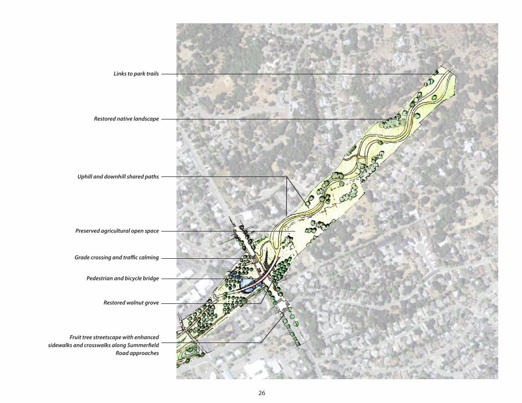
Linkstoparktrails
Restorednativelandscape
Uphillanddownhillsharedpaths
Preservedagriculturalopenspace
Gradecrossingandtrafficcalming
Pedestrianandbicyclebridge
Restoredwalnutgrove
FruittreestreetscapewithenhancedsidewalksandcrosswalksalongSummerfield
Roadapproaches
27
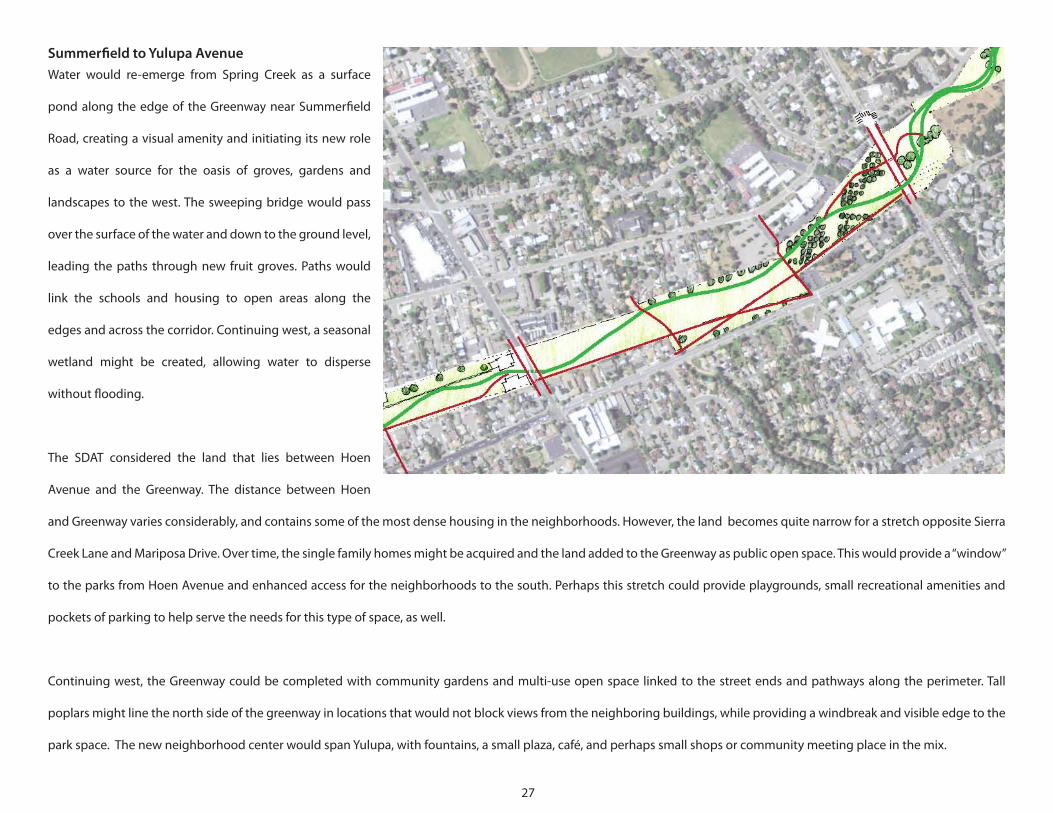
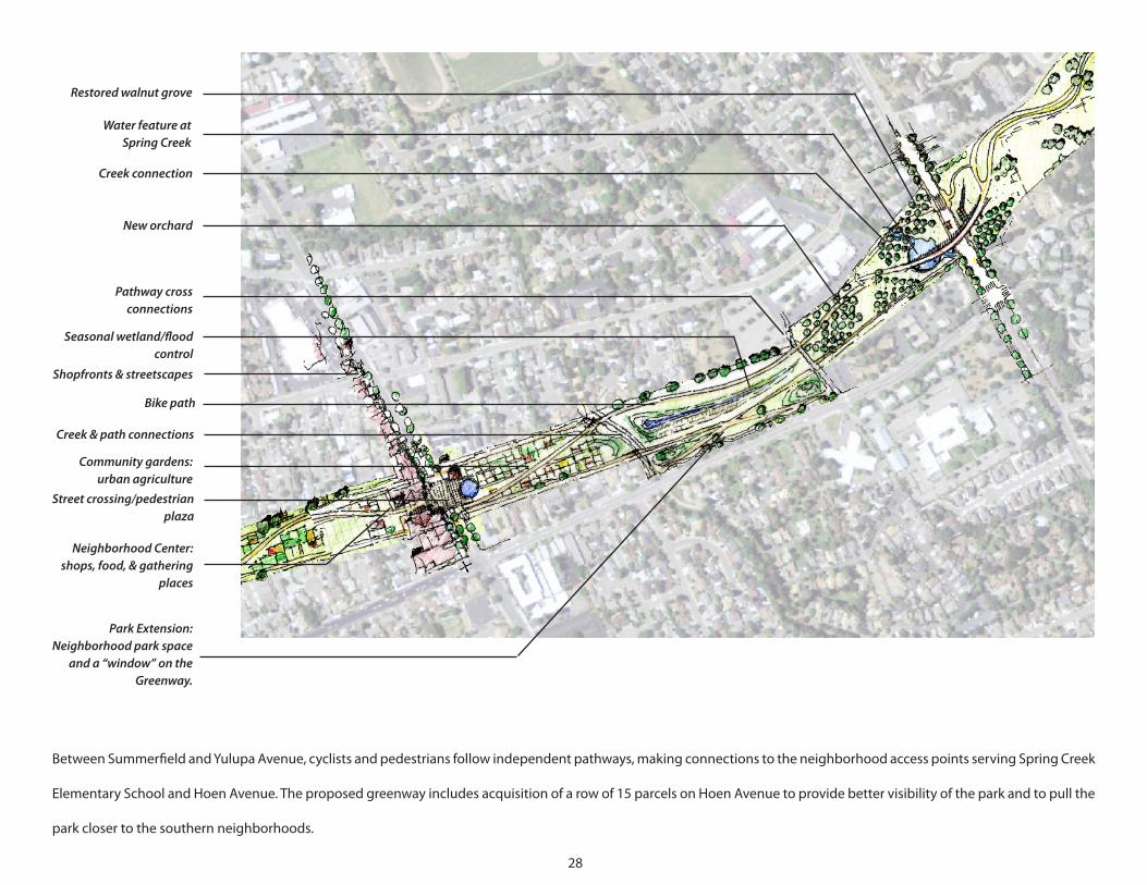
Summerfield to Yulupa AvenueWater would re-emerge from Spring Creek as a surface
pond along the edge of the Greenway near Summerfield
Road, creating a visual amenity and initiating its new role
as a water source for the oasis of groves, gardens and
landscapes to the west. The sweeping bridge would pass
over the surface of the water and down to the ground level,
leading the paths through new fruit groves. Paths would
link the schools and housing to open areas along the
edges and across the corridor. Continuing west, a seasonal
wetland might be created, allowing water to disperse
without flooding.
The SDAT considered the land that lies between Hoen
Avenue and the Greenway. The distance between Hoen
and Greenway varies considerably, and contains some of the most dense housing in the neighborhoods. However, the land becomes quite narrow for a stretch opposite Sierra
Creek Lane and Mariposa Drive. Over time, the single family homes might be acquired and the land added to the Greenway as public open space. This would provide a “window”
to the parks from Hoen Avenue and enhanced access for the neighborhoods to the south. Perhaps this stretch could provide playgrounds, small recreational amenities and
pockets of parking to help serve the needs for this type of space, as well.
Continuing west, the Greenway could be completed with community gardens and multi-use open space linked to the street ends and pathways along the perimeter. Tall
poplars might line the north side of the greenway in locations that would not block views from the neighboring buildings, while providing a windbreak and visible edge to the
park space. The new neighborhood center would span Yulupa, with fountains, a small plaza, café, and perhaps small shops or community meeting place in the mix.
28
Restoredwalnutgrove
WaterfeatureatSpringCreek
Creekconnection
Neworchard
Pathwaycrossconnections
Seasonalwetland/floodcontrol
Bikepath
Creek&pathconnections
Communitygardens:urbanagriculture
ParkExtension:Neighborhoodparkspace
anda“window”ontheGreenway.
Shopfronts&streetscapes
Streetcrossing/pedestrianplaza
NeighborhoodCenter:shops,food,&gathering
places
Between Summerfield and Yulupa Avenue, cyclists and pedestrians follow independent pathways, making connections to the neighborhood access points serving Spring Creek
Elementary School and Hoen Avenue. The proposed greenway includes acquisition of a row of 15 parcels on Hoen Avenue to provide better visibility of the park and to pull the
park closer to the southern neighborhoods.
29
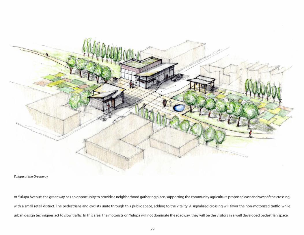
YulupaattheGreenway
At Yulupa Avenue, the greenway has an opportunity to provide a neighborhood gathering place, supporting the community agriculture proposed east and west of the crossing,
with a small retail district. The pedestrians and cyclists unite through this public space, adding to the vitality. A signalized crossing will favor the non-motorized traffic, while
urban design techniques act to slow traffic. In this area, the motorists on Yulupa will not dominate the roadway, they will be the visitors in a well developed pedestrian space.
30
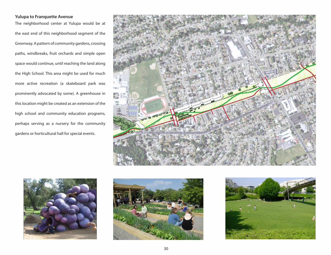
Yulupa to Franquette AvenueThe neighborhood center at Yulupa would be at
the east end of this neighborhood segment of the
Greenway. A pattern of community gardens, crossing
paths, windbreaks, fruit orchards and simple open
space would continue, until reaching the land along
the High School. This area might be used for much
more active recreation (a skateboard park was
prominently advocated by some). A greenhouse in
this location might be created as an extension of the
high school and community education programs,
perhaps serving as a nursery for the community
gardens or horticultural hall for special events.
31
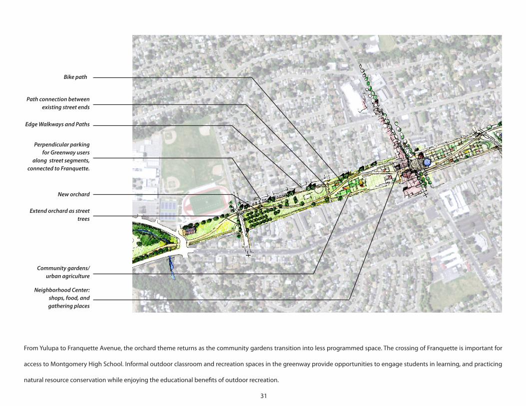
Bikepath
Pathconnectionbetweenexistingstreetends
EdgeWalkwaysandPaths
PerpendicularparkingforGreenwayusers
alongstreetsegments,connectedtoFranquette.
Neworchard
Extendorchardasstreettrees
Communitygardens/urbanagriculture
NeighborhoodCenter:shops,food,andgatheringplaces
From Yulupa to Franquette Avenue, the orchard theme returns as the community gardens transition into less programmed space. The crossing of Franquette is important for
access to Montgomery High School. Informal outdoor classroom and recreation spaces in the greenway provide opportunities to engage students in learning, and practicing
natural resource conservation while enjoying the educational benefits of outdoor recreation.
32
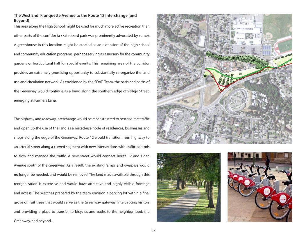
The West End: Franquette Avenue to the Route 12 Interchange (and Beyond)This area along the High School might be used for much more active recreation than
other parts of the corridor (a skateboard park was prominently advocated by some).
A greenhouse in this location might be created as an extension of the high school
and community education programs, perhaps serving as a nursery for the community
gardens or horticultural hall for special events. This remaining area of the corridor
provides an extremely promising opportunity to substantially re-organize the land
use and circulation network. As envisioned by the SDAT Team, the oasis and paths of
the Greenway would continue as a band along the southern edge of Vallejo Street,
emerging at Farmers Lane.
The highway and roadway interchange would be reconstructed to better direct traffic
and open up the use of the land as a mixed-use node of residences, businesses and
shops along the edge of the Greenway. Route 12 would transition from highway to
an arterial street along a curved segment with new intersections with traffic controls
to slow and manage the traffic. A new street would connect Route 12 and Hoen
Avenue south of the Greenway. As a result, the existing ramps and overpass would
no longer be needed, and would be removed. The land made available through this
reorganization is extensive and would have attractive and highly visible frontage
and access. The sketches prepared by the team envision a parking lot within a final
grove of fruit trees that would serve as the Greenway gateway, intercepting visitors
and providing a place to transfer to bicycles and paths to the neighborhood, the
Greenway, and beyond.
33
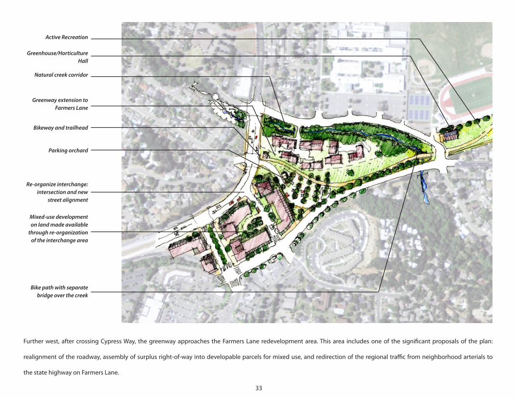
ActiveRecreation
Greenhouse/HorticultureHall
Naturalcreekcorridor
GreenwayextensiontoFarmersLane
Bikewayandtrailhead
Parkingorchard
Re-organizeinterchange:intersectionandnew
streetalignment
Mixed-usedevelopmentonlandmadeavailable
throughre-organizationoftheinterchangearea
Bikepathwithseparatebridgeoverthecreek
Further west, after crossing Cypress Way, the greenway approaches the Farmers Lane redevelopment area. This area includes one of the significant proposals of the plan:
realignment of the roadway, assembly of surplus right-of-way into developable parcels for mixed use, and redirection of the regional traffic from neighborhood arterials to
the state highway on Farmers Lane.
34
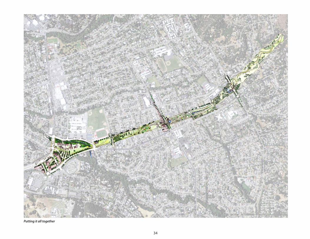
Puttingitalltogether
35
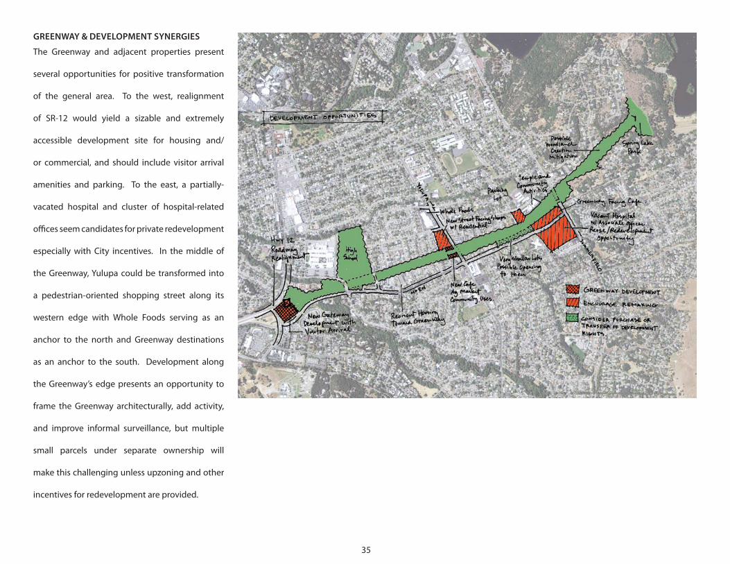
GREENWAY & DEVELOPMENT SYNERGIES
The Greenway and adjacent properties present
several opportunities for positive transformation
of the general area. To the west, realignment
of SR-12 would yield a sizable and extremely
accessible development site for housing and/
or commercial, and should include visitor arrival
amenities and parking. To the east, a partially-
vacated hospital and cluster of hospital-related
offices seem candidates for private redevelopment
especially with City incentives. In the middle of
the Greenway, Yulupa could be transformed into
a pedestrian-oriented shopping street along its
western edge with Whole Foods serving as an
anchor to the north and Greenway destinations
as an anchor to the south. Development along
the Greenway’s edge presents an opportunity to
frame the Greenway architecturally, add activity,
and improve informal surveillance, but multiple
small parcels under separate ownership will
make this challenging unless upzoning and other
incentives for redevelopment are provided.
36
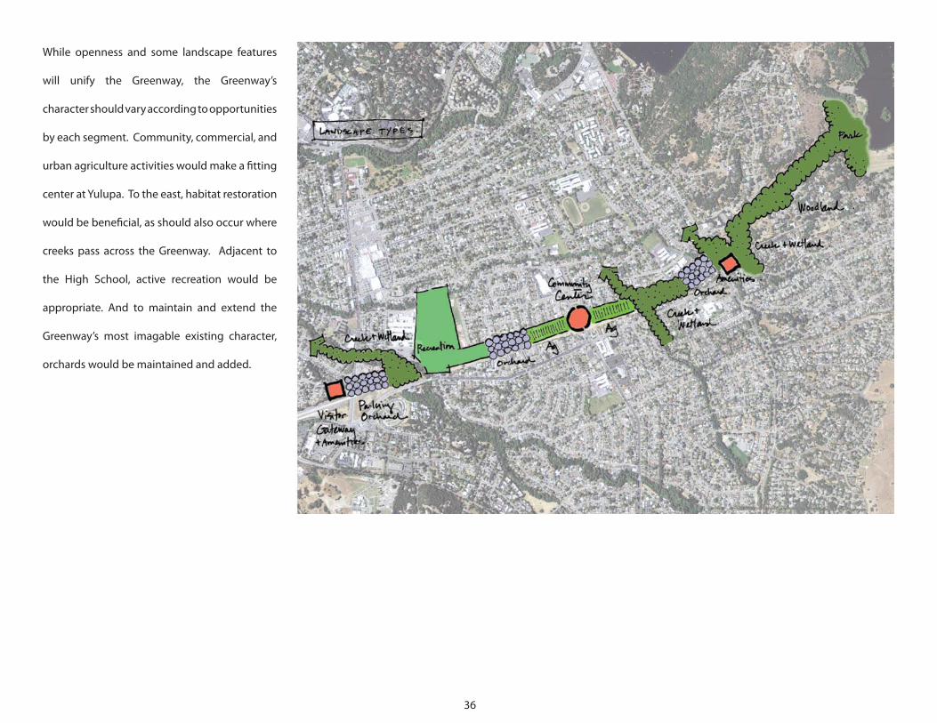
While openness and some landscape features
will unify the Greenway, the Greenway’s
character should vary according to opportunities
by each segment. Community, commercial, and
urban agriculture activities would make a fitting
center at Yulupa. To the east, habitat restoration
would be beneficial, as should also occur where
creeks pass across the Greenway. Adjacent to
the High School, active recreation would be
appropriate. And to maintain and extend the
Greenway’s most imagable existing character,
orchards would be maintained and added.
GREENWAY DEVELOPMENT: NEXT STEPS
38
THE SDAT IDENTIFIED SOME PROCESS ISSUES AND NEXT STEPS:
• A process moving forward and working with stakeholders.
• Working with the State on the disposition of the property.
• A focus on organizational issues, governance, and Public– Private Partnerships
(3Ps).
• Addressing funding issues.
PROCESS MOVING FORWARD
Many uses, amenities, and related issues were raised via the SDAT that ranged from
transportation circulation issues along the greenway and the City to the need for
playgrounds. How do we strategically take the next steps? Who does what? When?
1. Stakeholders - The three day SDAT effort greatly benefited from input from
many Santa Rosa citizens, City and County officials, and others. Moving forward,
the Greenway project will benefit from the continued engagement of these people
and by filling several key stakeholder gaps. Of note, we feel the project needs the
engagement of the business community, including developers, the college, and
all of the neighborhoods. The project leaders should identify and engage other
stakeholders missing from the effort to date.
2. Using the SDAT report to take next steps – This report should be a catalyst and
initial road map for moving forward. We recommend that within a month of this
report, the Mayor should direct key City agencies to develop a white paper to:
• Develop a work plan with city agencies, Sonoma County and other stakeholders
to build a strategy for implementing the Greenway, including financing;
• Outline issues and build toward general plan amendment; and
• Identify and plan other implementation steps.
3. Within a month the Greenway Campaign members, City, County, and other
stakeholders should work with Caltrans to create the initial trail along the
greenway via an “Encroachment Permit.”
4. Over a longer term:
Complete and implement the Greenway Strategy:
• Finalize status of the Greenway ROW issue.
• Establish a Management Board and structure.
• Develop and adopt a General Plan amendment consistent with the Greenway
Strategy.
• Maintain stakeholder engagement.
LAND OWNERSHIP ISSUES ASSOCIATED WITH THE GREENWAY
Addressing ownership and use issues of the ROW is critical for the Project. Most of the
land that makes up the Greenway is a right of way (ROW) originally purchased for a
highway by Caltrans in the1960s. Their requirements for disposing of such properties
essentially results in selling to the highest bidder. Realizing this is not a typical piece of
excess property and the importance of this ROW to the neighborhoods, City, region,
and State, there needs to be a strategy for working with CalTrans on the ownership
and use issues. We do not believe that this property is in fact excess property to state

39
ORGANIZATIONAL ISSUES / GOVERNANCE, AND PUBLIC – PRIVATE PARTNERSHIPS (3P’S)
Moving forward with the Project into the next phase will require a focus on governance
in both the short and long term.
1. The Southeast Greenway Campaign is the organization currently leading the
Project. They should focus on being the outreach / community arm of the effort and
seek to work with the City and other partners to create an implementation entity,
such as a management board, that is linked but separate.
2. While somewhat dependent on what direction the Project takes, an implementing
entity should be developed. This could take the form of a community development
corporation (CDC), redevelopment authority, management board, etc. Such an
organization will likely need to handle funds, property transfers, and potentially
administer the day-to-day tasks of managing the greenway (maintenance, managing
users, etc.). It would need to be representative of the stakeholders associated with the
Project and answerable to them, especially the City and the Campaign. An alternative
is to have the City parks and recreation department fill this role, but this may limit the
scope of the Project.
3. In addition to creating a core implementation and management entity, outlining
key initial public, private partnerships is important. These could include the following
under the overall direction of the lead managing entity:
transportation needs. It is excess to freeway needs, but a greenway is a legitimate
sustainable component of the transportation system, and should be treated as such.
Options for addressing the land ownership, disposition, and uses issues associated
with the greenway include:
1. Use Agreement / Memorandum of Agreement between the City (or other Greenway
entity) and Caltrans.
2. Purchase of the ROW by City from the State.
3. Multi-pronged use/ownership approach where portions of the ROW are sold and
developed, others preserved, etc per a detailed agreement, RFP process.
We recommend the Use Agreement approach, above, to get the greenway started.
This strategy needs to include the Greenway Campaign, City, Caltrans, elected officials,
and perhaps other State agencies. Addressing the ownership issues will require a
creative approach to financing and partnerships. The strategy needs to emphasize
the following:
• The transportation function that the greenway will provide;
• AB 32 (Climate Change) related benefits and furthering of State priorities;
• Other environmental benefits linked to potential storm water management
mitigation, wetland creation, stream restoration, etc;
• Recreational benefits;
• Educational benefits; and
• Economic development benefits.
40
• Educational Issues – creating a team that works with educational institutions in the area for
outdoor / environmental education uses and facilities associated with the greenway.
• Recreation Issues – ranging from bike trails to playgrounds.
• Cultural, Entertainment, and Art.
• Environmental Issues – ranging from dealing with streams, harvesting rain, maintaining
vegetation, habitat issues, environmental restoration, mitigation credits, GHG efforts, etc.
• Urban agriculture – whether for educational efforts, feeding the homeless, or for community
garden plots, this is likely to be an important component of the project.
• Development/ Redevelopment issues – depending on the final recommendations, there may
need to be mechanism to deal with development or redevelopment that is part of the Project.
This includes issues ranging from value capture from any development to land use and design
issues.
• Other uses – there needs to be mechanism for accommodating and benefiting from uses such as
water supply wells and pipelines, etc. in the greenway.
FUNDING
Funding will be a key issue for the Project, from capital projects to maintenance of the greenway and
its components. Ways to address the funding issue depend on the final form of the greenway and
its related activities. Funding could simply be a function of the City budgeting process or it could be
more complex and part of the management entity’s efforts to receive, collect, and spend funds for the
greenway.
We recommend using a creative approach of developing a small portion of the greenway to help
buy the property. Significant other portions of the greenway will be a transportation use, such as the
bike path. In addition, environmental mitigation efforts may help provide some funding. Traditional
transportation funds may help pay for the bike path- Surface Transportation funding, etc.
Sonoma County Agricultural Preservation and Open Space District
The Southeast Greenway should be part of any regional
multi-modal transportation strategy. As such, it is appropriate
that the land remain in Caltrans ownership with a lease for the
trail/greenway. If the parties ever think more local ownership is
desirable, the Sonoma County Agriculture Preservation and Open
Space District would be an ideal funding source.
Funded by a quarter cent sales tax, it is the largest and most
aggressive agency preserving open space in the county. Providing
a greenway for the region would fit perfectly into their mission.
The SDAT recommends that the Southeast Greenway be part of
a larger strategy for a greenway with a non-motorized multi-use
extending from Santa Rosa to Sonoma. There is probably no
better players to partner with for this purpose than Sonoma Open
Space and Caltrans.
41
Agriculture and Open Space District. The Sonoma County Agricultural Preservation
and Open Space District protects the agricultural, natural resource, and scenic open
space lands in Sonoma County. The County Board of Supervisors serves as the Board
of Directors. Funding for District activities comes in large part from ¼ cent increase to
County sales tax that was recently approved by voters in Measure F. The District has
bonded against a portion of this income to purchase conservation easements and
land. A Long-Term Acquisition Plan guides District funding decisions and should be
examined to determine whether this project is a likely candidate for funding.
Sonoma County Water Agency. The Sonoma County Water Agency would like to
purchase an easement through the property for its entire length for the construction
of a water main that can add “redundancy” to a system that would otherwise be
vulnerable during a major disaster. The easement might be as narrow as 30 feet.
Buildings and other obstacles to repairs would not be allowed in the easement, but
easily replaced features such as trails would be allowed. An exact alignment has not
been determined.
Grants. Federal and State grants might cover the cost of some improvements. In
recent years, grants have been regularly issued for: bicycle and transit facilities, “safe
routes to schools,” service to low-income neighborhoods, and reducing greenhouse
gas emissions. California’s “Urban Greening Grants” can pay for both planning
activities and capital improvements. Competition over limited funds is extreme, and
applications must provide a convincing argument consistent with evaluation criteria.
FUNDING – CAPITAL FOR ACQUISITION & IMPROVEMENTSActual right-of-way purchases by the City from Caltrans should be unnecessary if
Caltrans agrees to keep the corridor as a transportation corridor. This does not rule
out the need to purchase the greenway right-of-way in the future, although the value
of the greenway zoned for open space will be limited. The more valuable portions
of the former highway right-of-way should be purchased either directly by the
private sector or by Santa Rosa Redevelopment with a goal of eventually reselling
for economic development. Full greenway buildout does require some additional
purchases of private property off Hoen Avenue.
Caltrans has not determined the purchase price of its land. Typically, Caltrans has an
appraisal performed to determine the value of “highest and best” use of its land when
it “surpluses” its property. The City of Santa Rosa would be given right-of-first-refusal
for the property and would engage in negotiations to agree to fair value. California’s
legislature might be influenced to adopt provisions that would alter this typical
formula to the advantage of the community.
No single source of funding is likely to be sufficient. A variety of potential sources
have been described briefly and are based on community input received during the
AIA SDAT event. A complete analysis of each potential source should be conducted
to better understand opportunities and challenges.
42
approval as a stand-alone project but would be part of a package of open space
projects across the city. The outcome of any election is uncertain.
Neighborhood Improvement District. A parcel-based assessment might be applied
to a geographic “service area.” To do this, a property-based improvement district
would be formed after receiving support from a supermajority of area property
owners. These future revenues would then be bonded against to raise capital for
improvements that directly benefit the area.
Tax Increment Financing (TIF). Tax increment financing captures the additional
“increment” of property tax revenue that results from improvements and appreciation.
At present, TIF financing is only available to redevelopment agencies in areas where
findings of blight have been made. TIF financing diverts revenues from other public
coffers, and its future is uncertain at this time. Still, the potential for TIF funding should
be closely watched, especially since some California legislators have proposed that
TIF financing not be limited to redevelopment areas but also be available to deliver
infrastructure generally and in transit-oriented areas.
Private Development on Property. Portions of the Greenway could be made available
to private parties for development. Typical conditions applied to land surplused by
Caltrans prevent sale of the land but long-term land leases to private developers
by the City might be allowed. Care would need to be taken to make sure that the
Mitigation Receiving Areas. Development in other North Bay locations can result
in the loss of high-value habitat, which must be mitigated through the creation or
restoration of habitat. Land for these mitigations is often purchased. Some project
subareas might be appropriate as mitigation receiving areas and this potential should
be ascertained by a qualified biologist. One such subarea lies east of Summerfield,
where oak woodlands have been degraded and diminished. Restoration of creek
corridors might also qualify for mitigation funds.
Direct Philanthropy. Fund might be obtained target endowments, major corporations,
local businesses, and residents. “Naming” opportunities would encourage donations
and vary in scale from plaques on park benches to the naming of community centers
or playing fields.
Land Trusts. Land trusts, such as Sonoma Land Trust and the Trust for Public Land
offer valuable technical assistance for land acquisition strategies, and can play a vital
role in raising private and public revenues for land conservation.
Citywide Open Space Bond. Municipalities may bond against future tax revenues, if
a supermajority of voters approve (over two-thirds for many types of projects). Voters
have approved sales tax increases in recent years, so a parcel-based assessment may
be more viable politically. A citywide referendum would consult – and would need to
appeal to – all of Santa Rosa’s electorate. The Greenway would probably not receive
43
FUNDING – ON-GOING MANAGEMENT
The on-going costs of open space can be sizable. On-going costs would include:
maintenance, repairs, cleaning, events, utilities, insurance, administration, and other
activities. A governance mechanism for covering on-going costs would have to
be established in advance of the Greenway. Funding options for these and other
on-going activities are described below.
Operations Budgets Associated with Improvements. The Water District would cover
its own on-going costs and could contribute to “shared costs” such as the maintenance
of trails that are also used as utility access routes.
Agriculture & Open Space District. The District has the authority for short-term
funding of maintenance and operations at the inception of projects to assure their
success.
Parks Department. The City’s Parks Department might be assigned on-going
management but would do this using funds for activities citywide. Even in
economically flush times these funds are limited, and the Greenway would probably
need to emerge as a citywide priority for Parks funding to occur.
Non-Profit & Neighborhood Organizations. Donations might cover some part
of on-going costs but would require persistent efforts tasked to non-profits and
neighborhood organizations.
location and character of such private development is consistent with the vision and
core objectives of the Greenway project.
Development Fees In Lieu of On-Site Open Space. The Greenway would deliver
exceptional recreation opportunities to nearby development, and the City could
allow developers to opt out of on-site open space requirements (___ square feet per
dwelling unit) if a fee is paid into a fund for Greenway capital needs. Such funds must
be spent within a certain time frame and in some instances have been returned to the
developer if no improvements are made.
Development Fees In Lieu of On-Site Parking. The Greenway and associated
improvements will increase bicycle riding, walking and transit use. Developers might
be allowed a reduction in on-site parking requirements in exchange for paying a fee
to enhance alternative modes.
Carbon Credits. “Carbon credits” are now being purchased on the open market by
industries that wish to “off-set” their greenhouse gas (GHG) generation by funding,
indirectly, projects that sequester GHG or avoid its generation. In the United States,
this market is voluntary and the value of selling credits may be modest. Credits are
only sold when GHG would not otherwise be sequestered or avoided, and a long-term
commitment can be ensured.

44
management issues. The Project should work towards a detailed land use plan that
maps planned uses on the greenway. A greenway plan should outline these uses,
their purpose, users, and responsible parties. Where appropriate, funding issues
should be outlined along with other potential management issues. For example,
many have recommended community agriculture as a use of the greenway. The
management entity of the greenway needs to devise a method to determine
where this use should be located, what the terms are for those that want to have
a community garden (individual, school, etc.), and how to accommodate those
needs. Over time the need will likely change for the community garden use—the
demand may increase or decrease. How does this correspond to the other greenway
uses for trails, environmental restoration, recreation, gathering spaces, etc? This is
what a management plan for the greenway needs to address. The plan needs to be
implemented, managed, and updated by the entity that controls the greenway in
concert with the community’s interests.
Sponsorships. Corporations and foundations could be asked to sponsor events or
pay for “naming” of features. Community debate would be needed to understand the
extent to which the Greenway should be commercialized.
Events. The Greenway could host festivals, conferences, and other events. Facilities
could be rented and/or an admission fee could be charged.
New Parking Revenues. A fee might be charged for parking by visitors and others,
which would provide an on-going revenue source. In locations where the demand
for parking exceeds its supply, meters might be installed not only to raise revenues
but also to adjust demand, i.e. people who wish to pay nothing would walk farther
thereby increasing the availability of parking to people willing to pay.
Energy Production. Photovoltaic panels might be installed in sufficient quantity
to result in significant on-going income. PG&E would need to agree to pay cash for
energy generated, or energy generation could offset energy use within a district and
the Greenway would be compensated. Such arrangements remain rare and research
would be needed to determine options and the feasibility of any scheme. Donations
and grants would be needed to cover capital costs.
GREENWAY USE AND MANAGEMENT
There are many ideas for use of the greenway. Each use would involve a portion or
portions of the greenway, various stakeholders, and each would generate its own
45
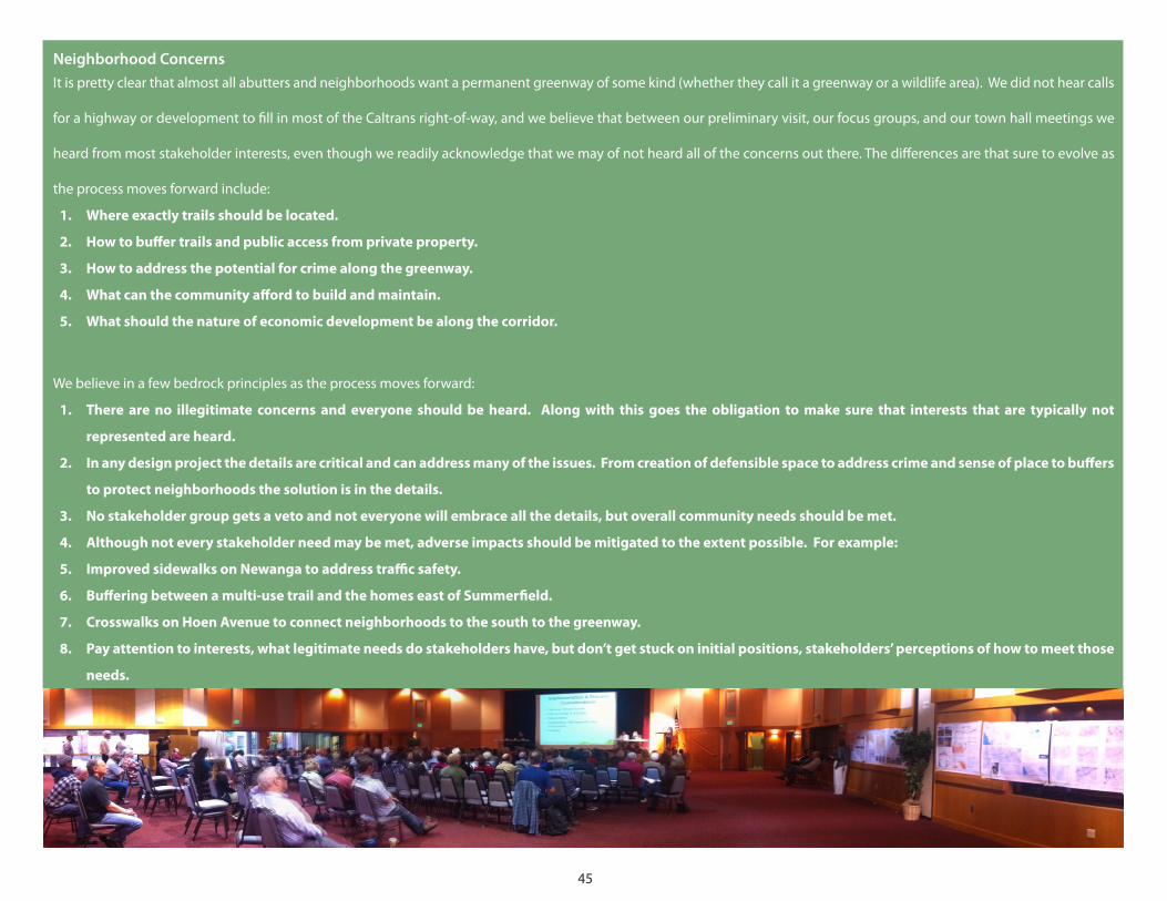
Neighborhood ConcernsIt is pretty clear that almost all abutters and neighborhoods want a permanent greenway of some kind (whether they call it a greenway or a wildlife area). We did not hear calls
for a highway or development to fill in most of the Caltrans right-of-way, and we believe that between our preliminary visit, our focus groups, and our town hall meetings we
heard from most stakeholder interests, even though we readily acknowledge that we may of not heard all of the concerns out there. The differences are that sure to evolve as
the process moves forward include:
1. Where exactly trails should be located.
2. How to buffer trails and public access from private property.
3. How to address the potential for crime along the greenway.
4. What can the community afford to build and maintain.
5. What should the nature of economic development be along the corridor.
We believe in a few bedrock principles as the process moves forward:
1. There are no illegitimate concerns and everyone should be heard. Along with this goes the obligation to make sure that interests that are typically not
represented are heard.
2. In any design project the details are critical and can address many of the issues. From creation of defensible space to address crime and sense of place to buffers
to protect neighborhoods the solution is in the details.
3. No stakeholder group gets a veto and not everyone will embrace all the details, but overall community needs should be met.
4. Although not every stakeholder need may be met, adverse impacts should be mitigated to the extent possible. For example:
5. Improved sidewalks on Newanga to address traffic safety.
6. Buffering between a multi-use trail and the homes east of Summerfield.
7. Crosswalks on Hoen Avenue to connect neighborhoods to the south to the greenway.
8. Pay attention to interests, what legitimate needs do stakeholders have, but don’t get stuck on initial positions, stakeholders’ perceptions of how to meet those
needs.
46
in building fronts that meet at the edge of the Greenway and are accessible by a
continuous path.
Active Uses. In some locations, retail and other active uses are desirable at street-level
and close to the sidewalk. Along Yulupa between the Greenway and Whole Foods,
a single-sided shopping street might be created that would establish a community
center that could meet a full range of needs. A café, conveniences, and amenities
should also be required at the west end of the Greenway where many visitors will
arrive and at Summerfield where redevelopment of the vacant hospital and associated
offices seems feasible in the long-term
Incentives. Development that is more appropriate could be encouraged by
“up-zoning” the most problematic parcels, such as between Hoen and the Greenway.
Doing so would make desirable forms of redevelopment by private parties more
likely. A variant of up-zoning is to provide a density bonus for the provision of certain
features and contributions. Parking and open space requirements might be reduced
to improve the feasibility of private redevelopment.
Redevelopment Authority. The City could establish a redevelopment area to help
assemble parcels where private development is encumbered by small parcels and
separate ownerships. Because it changes the rights of property owners, redevelopment
authority must have strong political support. If established, however, redevelopment
authority gives the community significantly more control over the rate of change and
PHASING
The Project potentially has many components and varying levels of cost and
complexity. We recommend a phased approach to the Project so that some benefits
of the greenway can be realized by the community sooner rather than later. For
example, the Project should seek to quickly build a bike and pedestrian path along
the greenway even if it is unpaved. This will clearly demonstrate progress, and the
community will see that the Project is for real and not just a planning effort. It will
also likely energize a broader number of citizens for the Project and better position it
for next steps.
ENCOURAGING APPROPRIATE ADJACENT DEVELOPMENT
Adjacent development could enhance the Greenway – or it could create conditions
that invite crime and unwanted behavior. Backyard fences comprise a large part of
the edge of the Greenway at this time and do not provide the informal surveillance
that comes with development when it fronts onto a space with entries and windows.
In addition, extraordinary investment in the Greenway deserves to be “framed” by
development that is attractive, increases safety, and offers amenities, and leverages
synergies. An obvious example would be cafes that add to the Greenway’s enjoyment
but also “place eyes” on the Greenway and make it more safe.
Form/Character-Based Provisions. Guidelines and standards should assure that,
as development occurs on adjacent land, it frames the Greenway with attractive
facades, frequent gates, and windows. If coordinated, new development could result
47
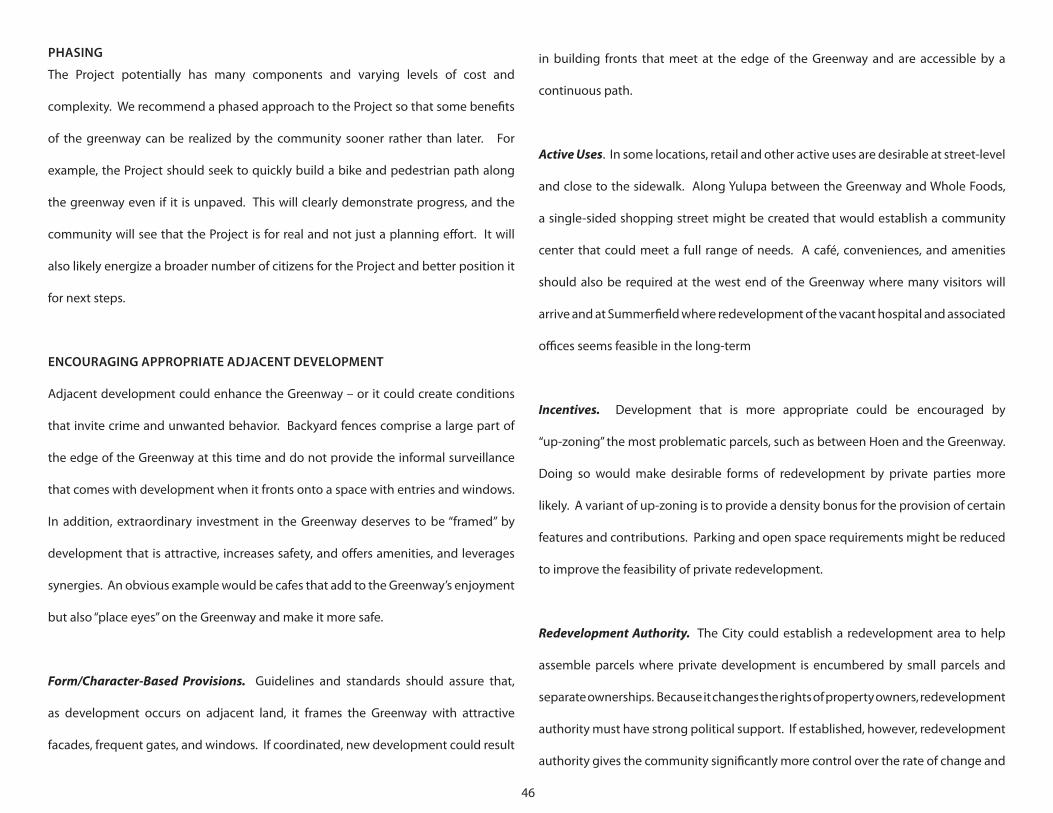
• On the south by Newanga, Hoen Ave., Hoen Ave. Frontage Road, and the final
Highway 12 freeway westbound off ramp west of Farmers Lane;
• On the west by the westerly start of the highway 12 freeway off ramp (west of
Farmers Lane).
character of development. In addition, at least 20% of redevelopment funding must
go toward affordable housing, and tax increment financing authority could provide
an effective tool for making street and open space improvements in the area (see
above).
CITY SMART GROWTH ISSUES
Currently the greenway is a blank spot in the City’s general plan. Moving some of
the greenway ideas forward will likely require an amendment to the general plan to
address the Santa Rosa’s vision, plan, and policies for the greenway and how it relates
to the rest of the City. We recommend the City develop a policy paper / white paper
that outlines the issues associated with the greenway from the City’s perspective
and then that be used to develop the draft amendment to the general plan. This
white paper could be used as a vehicle to begin outlining linked issues that may not
necessarily be part of the general plan, such as funding and management issues, etc.
In addition, it could be a vehicle to initiate conversations with the State and other
stakeholders on key aspects of the Project.
Because Santa Rosa already has a good general plan, the amendment necessary can
be tightly focused. We recommend that the area of the plan be the area bounded as
follows:
• On the north by the northerly extent of the Caltrans right-of-way;
• On the east by Spring Lake;
48
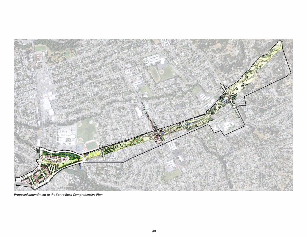
ProposedamendmenttotheSantaRosaComprehensivePlan
SUMMARY

50
The Southeast Greenway is a transformative project that can improve the
neighborhoods of southeastern Santa Rosa, make the City a more sustainable
community, and make the Northern Bay Area region a more desirable and more
sustainable place to live, work, and play.
The SDAT student focus group was enlightening. The students we met with came from
three high schools, with most of the students not from Montgomery High School, the
school on the greenway. They instantly grasped that this is a city-wide project that
would make their lives better, regardless of where they lived in Santa Rosa. Most of
the students anticipated leaving Santa Rosa after high school or college, but several
said it was projects like the greenway that would make the city more desirable.
51
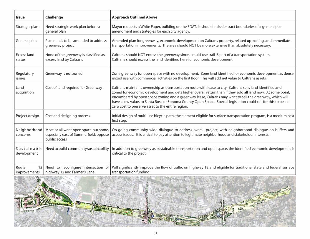
Issue Challenge Approach Outlined Above
Strategic plan Need strategic work plan before a general plan
Mayor requests a White Paper, building on the SDAT. It should include exact boundaries of a general plan amendment and strategies for each city agency.
General plan Plan needs to be amended to address greenway project
Amended plan for greenway, economic development on Caltrans property, related up-zoning, and immediate transportation improvements. The area should NOT be more extensive than absolutely necessary.
Excess land status
None of the greenway is classified as excess land by Caltrans
Caltrans should NOT excess the greenway since a multi-use trail IS part of a transportation system.Caltrans should excess the land identified here for economic development.
Regulatory issues
Greenway is not zoned Zone greenway for open space with no development. Zone land identified for economic development as dense mixed use with commercial activities on the first floor. This will add net value to Caltrans assets.
Land acquisition
Cost of land required for Greenway Caltrans maintains ownership as transportation route with lease to city. Caltrans sells land identified and zoned for economic development and gets higher overall return than if they sold all land now. At some point, encumbered by open space zoning and a greenway lease, Caltrans may want to sell the greenway, which will have a low value, to Santa Rosa or Sonoma County Open Space. Special legislation could call for this to be at zero cost to preserve asset to the entire region.
Project design Cost and designing process Initial design of multi-use bicycle path, the element eligible for surface transportation program, is a medium cost first step.
Neighborhood concerns
Most or all want open space but some, especially east of Summerfield, oppose public access
On-going community wide dialogue to address overall project, with neighborhood dialogue on buffers and access issues. It is critical to pay attention to legitimate neighborhood and stakeholder interests.
S u s t a i n a b l e development
Need to build community sustainability In addition to greenway as sustainable transportation and open space, the identified economic development is critical to the project.
Route 12 improvements
Need to reconfigure intersection of highway 12 and Farmer’s Lane
Will significantly improve the flow of traffic on highway 12 and eligible for traditional state and federal surface transportation funding
TEAM ROSTER
53
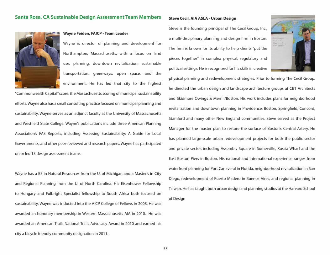
Santa Rosa, CA Sustainable Design Assessment Team Members
Wayne Feiden, FAICP - Team Leader
Wayne is director of planning and development for
Northampton, Massachusetts, with a focus on land
use, planning, downtown revitalization, sustainable
transportation, greenways, open space, and the
environment. He has led that city to the highest
“Commonwealth Capital” score, the Massachusetts scoring of municipal sustainability
efforts. Wayne also has a small consulting practice focused on municipal planning and
sustainability. Wayne serves as an adjunct faculty at the University of Massachusetts
and Westfield State College. Wayne’s publications include three American Planning
Association’s PAS Reports, including Assessing Sustainability: A Guide for Local
Governments, and other peer-reviewed and research papers. Wayne has participated
on or led 13 design assessment teams.
Wayne has a BS in Natural Resources from the U. of Michigan and a Master’s in City
and Regional Planning from the U. of North Carolina. His Eisenhower Fellowship
to Hungary and Fulbright Specialist fellowship to South Africa both focused on
sustainability. Wayne was inducted into the AICP College of Fellows in 2008. He was
awarded an honorary membership in Western Massachusetts AIA in 2010. He was
awarded an American Trails National Trails Advocacy Award in 2010 and earned his
city a bicycle friendly community designation in 2011.
Steve Cecil, AIA ASLA - Urban Design
Steve is the founding principal of The Cecil Group, Inc.,
a multi-disciplinary planning and design firm in Boston.
The firm is known for its ability to help clients “put the
pieces together” in complex physical, regulatory and
political settings. He is recognized for his skills in creative
physical planning and redevelopment strategies. Prior to forming The Cecil Group,
he directed the urban design and landscape architecture groups at CBT Architects
and Skidmore Owings & Merrill/Boston. His work includes plans for neighborhood
revitalization and downtown planning in Providence, Boston, Springfield, Concord,
Stamford and many other New England communities. Steve served as the Project
Manager for the master plan to restore the surface of Boston’s Central Artery. He
has planned large-scale urban redevelopment projects for both the public sector
and private sector, including Assembly Square in Somerville, Russia Wharf and the
East Boston Piers in Boston. His national and international experience ranges from
waterfront planning for Port Canaveral in Florida, neighborhood revitalization in San
Diego, redevelopment of Puerto Madero in Buenos Aires, and regional planning in
Taiwan. He has taught both urban design and planning studios at the Harvard School
of Design
54
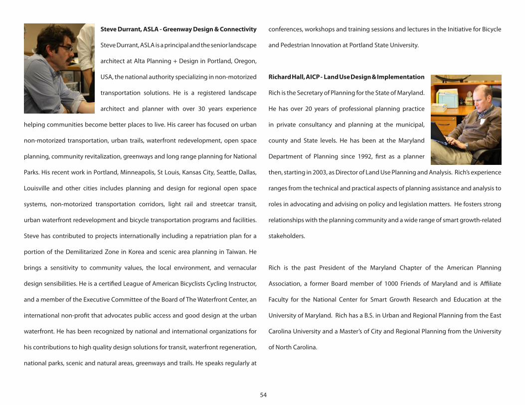
conferences, workshops and training sessions and lectures in the Initiative for Bicycle
and Pedestrian Innovation at Portland State University.
Richard Hall, AICP - Land Use Design & Implementation
Rich is the Secretary of Planning for the State of Maryland.
He has over 20 years of professional planning practice
in private consultancy and planning at the municipal,
county and State levels. He has been at the Maryland
Department of Planning since 1992, first as a planner
then, starting in 2003, as Director of Land Use Planning and Analysis. Rich’s experience
ranges from the technical and practical aspects of planning assistance and analysis to
roles in advocating and advising on policy and legislation matters. He fosters strong
relationships with the planning community and a wide range of smart growth-related
stakeholders.
Rich is the past President of the Maryland Chapter of the American Planning
Association, a former Board member of 1000 Friends of Maryland and is Affiliate
Faculty for the National Center for Smart Growth Research and Education at the
University of Maryland. Rich has a B.S. in Urban and Regional Planning from the East
Carolina University and a Master’s of City and Regional Planning from the University
of North Carolina.
Steve Durrant, ASLA - Greenway Design & Connectivity
Steve Durrant, ASLA is a principal and the senior landscape
architect at Alta Planning + Design in Portland, Oregon,
USA, the national authority specializing in non-motorized
transportation solutions. He is a registered landscape
architect and planner with over 30 years experience
helping communities become better places to live. His career has focused on urban
non-motorized transportation, urban trails, waterfront redevelopment, open space
planning, community revitalization, greenways and long range planning for National
Parks. His recent work in Portland, Minneapolis, St Louis, Kansas City, Seattle, Dallas,
Louisville and other cities includes planning and design for regional open space
systems, non-motorized transportation corridors, light rail and streetcar transit,
urban waterfront redevelopment and bicycle transportation programs and facilities.
Steve has contributed to projects internationally including a repatriation plan for a
portion of the Demilitarized Zone in Korea and scenic area planning in Taiwan. He
brings a sensitivity to community values, the local environment, and vernacular
design sensibilities. He is a certified League of American Bicyclists Cycling Instructor,
and a member of the Executive Committee of the Board of The Waterfront Center, an
international non-profit that advocates public access and good design at the urban
waterfront. He has been recognized by national and international organizations for
his contributions to high quality design solutions for transit, waterfront regeneration,
national parks, scenic and natural areas, greenways and trails. He speaks regularly at
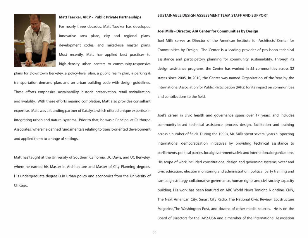
55
Matt Taecker, AICP - Public Private Partnerships
For nearly three decades, Matt Taecker has developed
innovative area plans, city and regional plans,
development codes, and mixed-use master plans.
Most recently, Matt has applied best practices to
high-density urban centers to community-responsive
plans for Downtown Berkeley, a policy-level plan, a public realm plan, a parking &
transportation demand plan, and an urban building code with design guidelines.
These efforts emphasize sustainability, historic preservation, retail revitalization,
and livability. With these efforts nearing completion, Matt also provides consultant
expertise. Matt was a founding partner of Catalyst, which offered unique expertise in
integrating urban and natural systems. Prior to that, he was a Principal at Calthorpe
Associates, where he defined fundamentals relating to transit-oriented development
and applied them to a range of settings.
Matt has taught at the University of Southern California, UC Davis, and UC Berkeley,
where he earned his Master in Architecture and Master of City Planning degrees.
His undergraduate degree is in urban policy and economics from the University of
Chicago.
SUSTAINABLE DESIGN ASSESSMENT TEAM STAFF AND SUPPORT
Joel Mills - Director, AIA Center for Communities by Design
Joel Mills serves as Director of the American Institute for Architects’ Center for
Communities by Design. The Center is a leading provider of pro bono technical
assistance and participatory planning for community sustainability. Through its
design assistance programs, the Center has worked in 55 communities across 32
states since 2005. In 2010, the Center was named Organization of the Year by the
International Association for Public Participation (IAP2) for its impact on communities
and contributions to the field.
Joel’s career in civic health and governance spans over 17 years, and includes
community-based technical assistance, process design, facilitation and training
across a number of fields. During the 1990s, Mr. Mills spent several years supporting
international democratization initiatives by providing technical assistance to
parliaments, political parties, local governments, civic and international organizations.
His scope of work included constitutional design and governing systems, voter and
civic education, election monitoring and administration, political party training and
campaign strategy, collaborative governance, human rights and civil society capacity
building. His work has been featured on ABC World News Tonight, Nightline, CNN,
The Next American City, Smart City Radio, The National Civic Review, Ecostructure
Magazine,The Washington Post, and dozens of other media sources. He is on the
Board of Directors for the IAP2-USA and a member of the International Association
56
campaigns, and as a professional artist and teacher, her interest in organizational
change, strategy, advocacy and creativity has led her to visual facilitation where
she combines skills as a deep listener and strategist who can easily synthesize,
visualize and organize emerging ideas. Julie has a degree in political science from
Purdue University and a Masters in Fine Art from Georgia State University. As a visual
facilitator, she conceptually guides and maps conversations by clearly synthesizing
and visualizing the wisdom in the room through deep listening for key concepts and
themes. The people and organizations Julie works with are able to see emerging
ideas woven into a story, allowing for navigation and common decisions about the
way forward. This process has proven to be a useful tool for guiding groups as they
undergo organizational change processes including strategic planning, visioning and
branding.
of Facilitators (IAF), the American Planning Association, the National Coalition for
Dialogue and Deliberation (NCDD), and the Mid-Atlantic Facilitators Network.
Erin Simmons - Director, AIA Design Assistance
Erin Simmons is the Director of Design Assistance at the Center for Communities by
Design at the American Institute of Architects in Washington, DC. Her primary role
at the AIA is to provide process expertise, facilitation and support for the Center’s
Sustainable Design Assistance Team (SDAT) and Regional and Urban Design Assistance
Team (R/UDAT) programs. In this capacity, she works with AIA components, members,
partner organizations and community members to provide technical design
assistance to communities across the country. To date, Erin has served as staff lead on
over 38 design assistance teams. Prior to joining the AIA, Erin worked as senior historic
preservationist and architectural historian for an environmental and engineering
firm in Georgia, where she practiced preservation planning, created historic district
design guidelines and zoning ordinances, conducted historic resource surveys, and
wrote property nominations for the National Register of Historic Places. She holds a
Bachelor of Arts degree in History from Florida State University and a Master’s degree
in Historic Preservation from the University of Georgia.
Julie Stuart - Graphic Recorder
Julie is principal with Making Ideas Visible, a graphic facilitation firm. Throughout
her career, Julie Stuart has drawn on both words and images to communicate ideas.
With experience in journalism, public relations, environmental politics, political
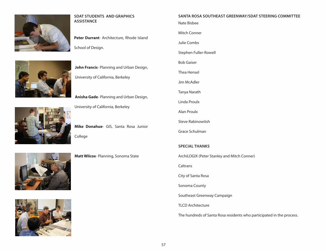
57
SDAT STUDENTS AND GRAPHICS ASSISTANCE
Peter Durrant- Architecture, Rhode Island
School of Design.
John Francis- Planning and Urban Design,
University of California, Berkeley
Anisha Gade- Planning and Urban Design,
University of California, Berkeley
Mike Donahue- GIS, Santa Rosa Junior
College
Matt Wilcox- Planning, Sonoma State
SANTA ROSA SOUTHEAST GREENWAY/SDAT STEERING COMMITTEE
Nate Bisbee
Mitch Conner
Julie Combs
Stephen Fuller-Rowell
Bob Gaiser
Thea Hensel
Jim McAdler
Tanya Narath
Linda Proulx
Alan Proulx
Steve Rabinowitsh
Grace Schulman
SPECIAL THANKS
ArchiLOGIX (Peter Stanley and Mitch Conner)
Caltrans
City of Santa Rosa
Sonoma County
Southeast Greenway Campaign
TLCD Architecture
The hundreds of Santa Rosa residents who participated in the process.