imagining the tar sands 1880 -1967 and beyond · the visual record of activity in the athabasca tar...
TRANSCRIPT

• ISSUE 3-2, 2012 • 68IMAGINATIONS
ImagInIng the tar SandS 1880-1967 and Beyond
IMAGINING ThE TAr SANdS 1880 -1967 ANd BEyONd
mIke gISmondI and deBra J. davIdSon
For much of the history of Alberta’s tar sands, a series of visual conventions have shaped Canadian imaginaries of the resource, the emergence of the non-conventional oil industry, and the mining of oil. We introduce a series of archival images dating from 1880 until the opening of Great Canadian Oil Sands (Suncor) in 1967, to analyze how visual representations were used to justify government and public support for bitumen mining and refining, to legitimate state research into the separation of oil from the sands, and to ideologically sustain public funding of the development of this unique Canadian resource industry. We conclude that many elements of these early positive normative conceptual frameworks remain in play today, used by corporate and government meaning–makers to blunt contemporary critiques by the public of social and ecological tradeoffs, and ultimately to legitimate Alberta and Canada’s pursuit of non-conventional oil as an acceptable energy future.
Au cours de l’histoire albertaine, une série de conventions visuelles ont contribué à façonner l’imaginaire canadien des ressources naturelles, l’émergence d’une industrie pétrolière non conventionnelle, et les pratiques d’extraction minière. Nous proposons ici un regroupement d’images d’archives allant de 1880 jusqu’à l’ouverture de Great Canadian Oil Sands (Suncor) en 1967, afin de montrer le rôle de ces conventions visuelles dans plusieurs sphères. Premièrement dans la justification des soutiens gouvernementaux et publiques de l’industrie d’extraction et de raffinage. Ensuite dans la légalisation des recherches sur la séparation du pétrole et des sables. Enfin dans le maintien idéologique du financement public pour le développement de cette industrie d’exception au sein des ressources canadiennes. En conclusion, nous indiquons que même aujourd’hui les entreprises et les faiseurs d’opinions politiques utilisent plusieurs éléments de ces premières méthodes conceptuelles normatives. Ils le font pour émousser les critiques contemporaines en faveur des compromis social et écologique, et ultimement pour légitimer l’industrie d’extraction pétrolière non conventionnelle dans l’avenir.
[…B]y seeking to comprehend this photograph—by looking at it, by looking through it, and by thinking with it—in terms of the meanings that swirled around it, we can achieve a clearer and fuller understanding of time and place, landscape and iden-tity, image and reality. (Joan Schwartz 107)

69 • ISSUE 3-2, 2012 • IMAGINATIONS
gISmondI and davIdSon
Fig. 1 G.B. Dowling, Geological Survey of Canada; Tar Sands Athabasca River, Alta
Introduction
The visual record of activity in the Athabasca tar sands of Northern Alberta extends more than 120 years and claims over a century of storytelling, in which the photographic images built a public imaginary of the landscape and the industry.1Early photographs helped national and international audiences picture a remote geographic place and led them to see in the tar sands its economic potential for a young Canadian nation. In the province of Alberta (founded in 1905) that visual record worked alongside political narratives of meaning-making to legitimate an uncertain and precarious public investment throughout the entire time period of our study. Representing the tar sands as an immense resource in the wilds of Canada, and its exploitation as heroic, historic, and carried out by hardy Albertans, carried the quest to extract non-conventional oil from the tar sands
into broader Canadian narratives of the conquest of nature: the holy grail to countrywide nation-building. 2
From the late 1880s onwards, photographs of “the Athabasca tar sands” would begin to evoke both a geographic place and a natural resource in the minds of colonizers and settlers in Calgary and Edmonton or interested bureaucrats in Ottawa, and investors in faraway Montreal, New York, or London, England. The camera use by geologists, surveyors, and travelers added credibility to claims about potential natural riches at the edge of a remote northwest Canadian frontier. Images picturing the landscapes as extractive (Pratt and Karvellas; Schwartz 966) were reinforced by the classical perception that the camera provided a documentary record of reality (Mraz 163-192). For much of its history, a series of visual conventions or tropes have

• ISSUE 3-2, 2012 • 70IMAGINATIONS
ImagInIng the tar SandS 1880-1967 and Beyond
shaped Canadian perceptions of the mining of oil and the industry’s difficult emergence. Two exceptionally positive storylines emerged: (1) the application of human ingenuity, science, and technology to release useable crude oil from the bonds of sandy bitumen, and (2) the key importance of the Alberta state and public investment in the process to open Alberta’s northern wilderness to commercial investment and industry. Like all powerful social facts, these well-constructed meanings and images now appear familiar to modern readers, internalized and normalized, part of our mental inventory of representations of the development of this unique Canadian resource. In this paper, we highlight a series of key individuals, projects, and socio-historical chapters in that process of normalization. Many of these early photographs and associated storylines have been reproduced in archives and newspapers, museum displays and interpretive exhibits, magazines and textbooks, a national stamp depicting the bituminous sands industry of Alberta, and a designated Alberta heritage site (Bitumont). Archetypes of industrial development, they mediate public perceptions of reality, and until recently sustained the industry’s reputation in a positive light. As Schwartz explains, “if photographs record outward appearance with unparalleled realism, their optical precision does not preclude ideological content” (169).
Concentrating on the dominant readings of tar sands visuals from 1880 until the opening of Great Canadian Oil Sands (Suncor) in 1967, we analyze how a network of images and meanings teamed up with scientific or political explanations to legitimate state support for bitumen mining, the separation of oil from the sands, and the commercial viability of the industry. Geographers Castree and Braun argue that images work together with discourses as acts “of conceptual construal” (167): what Hajer and Versteeg describe as an “‘epistemic’ quality. . . inaccessible to subjects but that nevertheless steer them in their thinking” (181). In this paper, we draw to the surface patterns across a series of historical images of the tar sands to argue how these elements formed part of an increasingly sophisticated cultural web of meanings that guided public consciousness
in these early years. We conclude that many of the elements of these conceptual frameworks remain in play in contemporary politics, used in new ways to continue to influence meaning–making about society/nature relations, blunt the contemporary critique of social and ecological tradeoffs, and legitimate state support for non-conventional oil for the future of civilization (Davidson and Gismondi).
Age of Discovery
Looking at photographs in historical geography is, ultimately, not a search for ‘truth’ but rather a mode of inquiry. By going beyond subject content and photographic realism to think more broadly about the way in which photographs, gathered in the empirical practices of exploration and surveying, played an active role in the production of geographical knowledge and the construction of imaginative geographies. (Schwartz 125)
The opening photograph, taken on the banks of the Athabasca River in 1892, shows two men, perhaps Government of Canada geologists, dwarfed by an enormous band of tar sands (Fig. 1). The angle of the image, the apparent scale of the resource, the survey marker, and the gaze of government employees confirm observations by adventurers, explorers, and naturalists who reported tar ponds and streams of oil weeping down the riverbanks of the Athabasca River. Dowling’s photographs, while highly directed, added credibility to early reports in 1882 by Dr. Robert Bell, a field geologist who became acting director of the Geological Survey of Canada. Bell believed that beneath the sandy pitch and belts of black tar sands lay “pools of petroleum.” Like other post-Confederation government survey work in the northwest, Dowling’s reports also affirmed Canada’s sovereignty at a time when the United States and Britain coveted the same region. Inventories, maps, and reports by surveyors and engineers were both practical tools and symbols of state power. Replacing the older practice of hand drawn landscapes, early photographs detailing the potential of the tar sands brought documentary certainty to the tar sands and its place in “the idea of a transcontinental national existence” (Zeller 9).

71 • ISSUE 3-2, 2012 • IMAGINATIONS
gISmondI and davIdSon
Other pioneers like Count Alfred Von Hammerstein would punch holes along the Athabasca River in the early 1900s hoping to hit conventional oil. Kodak images of Von Hammerstein’s drill works appeared in Agnes Deans Cameron’s widely read The New North: Being Some Account of a Woman’s Journey through Canada to the Arctic (1909, see Fig. 2). While the Count was unsuccessful drilling for “elephant pools of oil,” Deans Cameron’s book and its images became a best seller and made her a media celebrity. Deans Cameron would lecture across Canada and the United States about her “Journeys through Unknown Canada.” As a Canadian Government representative in Britain, with magic lantern slides of her photographic images on display, she promoted Prairie immigration. She offered this description of the Athabasca region:
In all Canada there is no more interesting stretch of waterway than that upon which we are entering. An earth-movement here has created a line of fault clearly visible for seventy or eighty miles along the river-bank, out of which oil oozes at frequent intervals. […] Tar there is […] in plenty. […] It oozes from every fissure, and into some bituminous tar well we can poke a twenty foot pole and find no resistance. (71)
Her photographs were recently reproduced in an exhibit at the Canadian Museum of Civilization in Ottawa, Canada.
As a promoter, Von Hammerstein would work the region for almost forty years. This image (Fig. 3) from the early 1900s is attributed to him by the Library and Archives Canada and shows tar weeping from the river bank with the scribbled note “Tar Sands and flowing Asphaltum in the Athabasca District ca. 1908.” The same image is also held by The Alberta Provincial Archives and includes the legend “millions of tons of material in sight.” The Provincial Archive of Alberta file advises that the image is a “Fragment of printed publicity leaflet on the Athabasca District’s oil potential and illustration of oil sand exposure on river bank.” A gloss of mathematical scribbles left by one eager reader suggests more (Fig. 4).
Fig. 2 Robson Studio, Hammerstein’s Oil Works, Oil and Gas Well, Athabasca District

• ISSUE 3-2, 2012 • 72IMAGINATIONS
ImagInIng the tar SandS 1880-1967 and Beyond
Fig. 3 Alfred Von Hammerstein, Tar Sands and Flowing Asphaltum in the Athabasca District
Images of bitumen and oil seeping from the Athabasca River banks (Fig. 3 and 4) acted like eyewitness testimony (Burke) invoking the scale and immensity of the resource for those living in distant cities, reinforcing narratives of commercial possibility especially in the minds of government administrators and petroleum investors. The effect of image on perception stemmed from an historically specific view, as Schwartz argues, that camera images were a mirror of reality: “the society which produced and consumed these images placed
unwavering faith in the truthfulness of the photographic image and its ability to act as a surrogate for first-hand seeing”; the photograph became a “surrogate for first-hand observation—a convincing visual experience akin to ‘being there’” (Schwartz 113). Presenting cornucopian images of the Canadian North, members of the Geological Survey and entrepreneurs like Von Hammerstein and writers like Deans Cameron partook in a process that anthropologists call turning sights into sites,’ whereby images become cultural or symbolic shorthand that instill preferred meanings onto a geographic space. At the start of the petroleum and automobile age in Canada, such images from Alberta’s North presaged new economic staples and indicated new directions for industrial futures. As with other staples, the tar sands also promised enormous wealth and personal power for those who controlled it (Huber 2008). The stories and visual impressions of the promoters of the tar sands were not all truthful, but they were true in their effects; drawing entrepreneurs, investors, and both levels of government into the region, as well as into a particular way of seeing the landscape. Von Hammerstein would be named to the Canadian Petroleum Hall of Fame in 2011 (“Honoured CPHFS Members”).The Government Gaze Sydney Ells, considered by some the “father of Alberta bituminous sands research” (Ells 101) spent over thirty years as surveyor, cartographer, and engineer researching tar sands for the Canadian Government Department of Mines. His field survey of the bituminous sands along the Athabasca River in summer 1913 examined reaches and tributaries south and north of Fort McMurray, first presented in a Preliminary Report published in 1914 that comprised over eighty-five dense pages, including forty photographs.
In 1962, the Canadian Department of Mines published his memoir, Reflections of the Development of the Athabasca Oil Sands—a less technical narrative of his career in the region, covering the years between 1913 and 1945. From opening poem to closing words, Ells sketches a manly frontier (Fig. 5) where skilled ‘white’ engineers supervised urban tenderfoots, with

73 • ISSUE 3-2, 2012 • IMAGINATIONS
gISmondI and davIdSon
Fig. 4 Oil Sand Exposure Near Fort McMurray

• ISSUE 3-2, 2012 • 74IMAGINATIONS
Fig. 5 Roy Ells, Dr. Sidney Ells at Fort McMurray Tar Sands
75 • ISSUE 3-2, 2012 • IMAGINATIONS
gISmondI and davIdSon
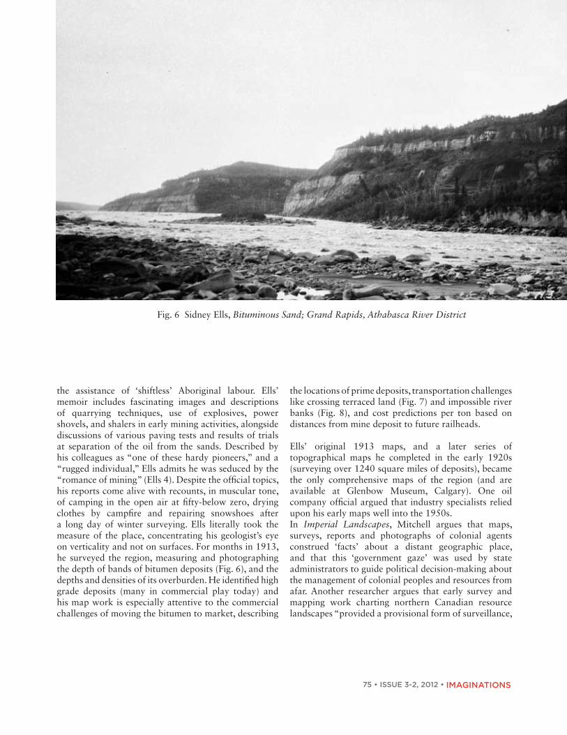
the assistance of ‘shiftless’ Aboriginal labour. Ells’ memoir includes fascinating images and descriptions of quarrying techniques, use of explosives, power shovels, and shalers in early mining activities, alongside discussions of various paving tests and results of trials at separation of the oil from the sands. Described by his colleagues as “one of these hardy pioneers,” and a “rugged individual,” Ells admits he was seduced by the “romance of mining” (Ells 4). Despite the official topics, his reports come alive with recounts, in muscular tone, of camping in the open air at fifty-below zero, drying clothes by campfire and repairing snowshoes after a long day of winter surveying. Ells literally took the measure of the place, concentrating his geologist’s eye on verticality and not on surfaces. For months in 1913, he surveyed the region, measuring and photographing the depth of bands of bitumen deposits (Fig. 6), and the depths and densities of its overburden. He identified high grade deposits (many in commercial play today) and his map work is especially attentive to the commercial challenges of moving the bitumen to market, describing
Fig. 6 Sidney Ells, Bituminous Sand; Grand Rapids, Athabasca River District
the locations of prime deposits, transportation challenges like crossing terraced land (Fig. 7) and impossible river banks (Fig. 8), and cost predictions per ton based on distances from mine deposit to future railheads.
Ells’ original 1913 maps, and a later series of topographical maps he completed in the early 1920s (surveying over 1240 square miles of deposits), became the only comprehensive maps of the region (and are available at Glenbow Museum, Calgary). One oil company official argued that industry specialists relied upon his early maps well into the 1950s. In Imperial Landscapes, Mitchell argues that maps, surveys, reports and photographs of colonial agents construed ‘facts’ about a distant geographic place, and that this ‘government gaze’ was used by state administrators to guide political decision-making about the management of colonial peoples and resources from afar. Another researcher argues that early survey and mapping work charting northern Canadian resource landscapes “provided a provisional form of surveillance,

• ISSUE 3-2, 2012 • 76IMAGINATIONS
ImagInIng the tar SandS 1880-1967 and Beyond
Fig. 7 Sidney Ells, Terrace Structure, Athabasca River
control, and supervision;” a “projection of state power” over places and peoples (Sandlos 396). Anthropologist James Scott calls these “maps of legibility,” conventional descriptions which simplified complex realities for state administrators in ways that marginalized certain social groups and practices, or valued certain aspects of geologic formations, wildlife, and ecosystems over others (2).
Aboriginal peoples are glimpsed occasionally in the dotted lines on Ells’ maps around reserves, or in images (Fig. 9) or diary descriptions of their labour as trackers and freighters hauling the tar sands south. But like most reports of the age, they are empty of Aboriginal land uses—an omission that Mitchell (10, 15) calls a ‘social hieroglyph’ of the historical social relations they conceal.
Ells’ early reports and memoir are also largely devoid of attention to ecosystems; for him, natural systems (climate, local foods, disease, weather, terrain, waterways, and more) are subtly classified as either supporting or inhibiting extractive strategies. Nature is not denied, but circumscribed. At best the muskeg, forest, and climate are presented as human trials, obstacles to
be endured and conquered: “A fly-infested country, of many streams, in timbered or burned out areas, and almost limitless muskeg” (Ells 10), to be overcome, in the masculinist discourse of the day, by hardy men charged with developing a modern industrial nation. But it was under the dual gaze of commerce and government that the Athabasca territory became constructed into a commodity frontier, understood in terms of deposits of natural resources, relationships to markets, and obstacles to extraction of tar sands for human use. Rivers were seen for their navigable properties, not as natural ecosystems—as means to move people and technologies inland or move products out (only later would the importance of water for the separation and waste tailings processes become important). Forests and muskeg became reduced to obstacles—not sources of biodiversity and habitat. The original inhabitants simply became a part of that landscape. Aboriginal peoples became at best a potential labour force or disappeared into a wilderness terrain. “Objective images” and “disinterested scientific facts” began to appear as more authentic depictions of the region, displacing indigenous and local understandings, while affirming traveler observations with expert confirmation of geological

gISmondI and davIdSon
Fig. 8. Sidney Ells, Steepbank River
Fig. 9 Dr. Karl Clark, Packing dogs with Tar Sands, Ells River. The description reads “unidentified men with dogs packed with tar sands.”
Fig. 10 H. S. Spence, Sydney Ells at Tar Sands Plant

• ISSUE 3-2, 2012 • 78IMAGINATIONS
ImagInIng the tar SandS 1880-1967 and Beyond
formations, navigation routes, engineering opinions on potential mining sites and so on—a topography of exploitation.
Ells, the engineer blended physical masculinity with a confidence in the technological domination of nature (Fig. 10). Such attitudes were common among engineers at this time, part of their civilizing mission. Early ecologists shared in this ideology of technological progress in the 1920s, convinced of the role of scientific knowledge in helping human society overcome the constraints of nature (Lecain 57-59). Despite Ells’ predictions, the scale of tar sands operations remained limited for many decades. The arrival of the railway to the region made some things easier. But the resource itself was not quite so free and easy (Fig. 11) as first depicted. Commodification of the resource required new methods of separation of oil from the sands that would take decades to evolve, dampening this early enthusiasm.
Political Handfuls of Tar
Railways were crucial to the Canadian extractive economy. In the early 1900s business pressure mounted for the Canadian and Alberta Governments to support railway expansion westwards and northwards. Zaslow notes that initially “the oil boom [in 1910 in the tar-
sands lands] quickly faded. . . but while it lasted, it strongly affected the railway program of the Alberta Government” including their commitment to the proposed Alberta and Great Waterways rail line to join Edmonton to Fort McMurray (212). Financial issues associated with its development would force a government resignation and a new election in 1910, but the rail line reached Draper in 1922 (12 kilometers south of McMurray) and McMurray in 1925-26. Alberta developed considerable public debt building northern transportation and communication (Richards and Pratt 19-20). Images of well-dressed men, with handfuls of tar, repeat across the visual record of this time. This first image (Fig. 12) includes right to left: S.E. Mercier, Northern Construction Company; Hon V.W. Smith, Minister of Railways; Alberta Premier Herbert Greenfield; and Colonel Jim Cornwall, Northern Transportation Company. Greenfield, Smith and the United Farmers of Alberta party were first elected that year, the powerful hands of politics and public transportation alongside those of private finance at the tar sands in early 1921.
Men in urban business attire out in nature (Fig. 12) suggest the easy availability, access, and abundance of the resource and the apparent ease of its potential extraction. Edmonton business men, in dress clothes and fashionable urban headgear (Fig. 13), collecting
Fig. 11 Sidney Ells, Working Face of Bituminous Sands

gISmondI and davIdSon
Fig. 12 Oil Sands - ½ mile north of Fort McMurray
Fig. 13 Oil Saturated Stones Examined by a Group of Edmonton Business Men
handfuls of tar sands or dipping into liquid tar pools (Fig. 14), sent a message about the riches of this place as a kind of repository of black gold.
The arrival of well-dressed men at the tar sands suggests the coming of commercial investment to the region (Fig. 13-15). Alongside reports of the mile-by-mile approach of the railway, such images no doubt encouraged distant
publics, shareholders and the state. But the images also spoke to a difficult problem: how to separate out the oil from the sands and the need for investment in the process of extraction. The next stage in this process was to bring such visions to fruition through science.

• ISSUE 3-2, 2012 • 80IMAGINATIONS
ImagInIng the tar SandS 1880-1967 and Beyond
Fig. 14. Robert Fitzsimmons, Unidentified Man Checking out a Surface Pool of Bitumen

81 • ISSUE 3-2, 2012 •
gISmondI and davIdSon
Fig. 15 Group Examining Tar Sands, Fort McMurray, Alberta. Left to Right: Walter Jewitt, Ted Nagle, Bill McDonald.
Fig. 16 Rutherford Caley, Man Looking at Oil Flowing Freely from Tar Sands Exposed to Heat of Sun

• ISSUE 3-2, 2012 • 82IMAGINATIONS
ImagInIng the tar SandS 1880-1967 and Beyond
Fig. 17 Daniel Diver, Interior of Shack with Sample of Tar Sands and Extractions, Fort McMurray. Remarks: “Pail on stove holds tar sands, bottle shows oil and a milk like substance. Gas comes from tube at other end. 8 pounds, sand produces 12 ounzes, oil; 6000 poundss, sand produce 1 pound bitumin (sic).”
Fig. 18 McDermid Studios Edmonton, Dr. Karl Clark, University of Alberta, Tar Sands Department.

83 • ISSUE 3-2, 2012 • IMAGINATIONS
gISmondI and davIdSon
Karl Clark: Geographic Sites of Science
The transportation costs to move heavy and unwieldy bituminous sands to market heightened the need for an industrial process to convert bitumen into a liquid form that could flow southwards for commercial use and profit. But bitumen’s special material conditions—it was dense, heavy, and mixed with sand, water, other chemicals, and clays—meant that large investments in science would need to be injected for an extensive period of time before any returns on those investments would begin to flow. No process to separate the oil from the tar sands appeared to work well at an industrial scale, although many images (Fig. 17) record homespun efforts at separation.
One of those whose perseverance would prevail was Dr. Karl Clark, a University of Alberta scientist, and employee of the provincially-supported Research Council of Alberta (founded in 1921 with the initial purpose of pursuing industrialization of the Athabasca sands). Clark is credited with developing a hot water separation method in 1926. Over many years, Clark moved his research back and forth from university laboratory to Edmonton warehouse yards to wilderness workshop.
Images like that of the scientist at work (Fig. 18), lab coat stained in oil, affirmed Clark’s efforts at applied science. Clark’s work in the field brought increased authority to his laboratory science at the University of Alberta and to the government’s Alberta Research Council, and vice versa. Pilot plants were built in Edmonton and the Dunvegan rail yards (Fig. 19) in 1924 and rebuilt in 1929 (Ferguson 191 and 53-54).
Fig. 19 D. S. Pasternack, Oil Sands Extraction Plants- Edmonton Dunvegan Yards

• ISSUE 3-2, 2012 • 84IMAGINATIONS
ImagInIng the tar SandS 1880-1967 and Beyond
Fig. 20 D. S. Pasternack, Oil Extraction Plant - Clearwater River Plant. The plant processed 800 tons of oil sands in the summer of 1930, and yielded over 75 tons of bitumen (Ferguson 54).
Fig. 21 Sidney Ells, Men Carrying Sacks of Bituminous Sands as Shipment Passes Cascade Rapids, Athabasca River, Alberta.
85 • ISSUE 3-2, 2012 • IMAGINATIONS
gISmondI and davIdSon
While the end goal was commercial investment and profit, the scientific challenge itself appeared to be a strong source of enthusiasm. Barry Ferguson argues that “the fact that the Premier himself was chairman [of the Research Council of Alberta] and that the board included both cabinet ministers and the University President” indicates its importance (52). Whether intentional or not, scientific and technological problem solving brought a dose of heroism to the process that often obscured the ultimate ends—which were always commercial exploitation. Images of bush laboratories confirmed that lab experiments and processes could be adapted to the terrain and climatic conditions. This visually-conveyed presence on the land was crucial to legitimating Clark’s work, and to attracting future commercial investment to the tar sands. Separation was shown to work in nature: that is, in “real” conditions albeit at a moderate scale. Field experiments brought with them the powerful authority of science and the
university, and confirmed a separation process based on universal principles of chemistry. In Putting Science in Its Place, Livingstone argues that the location of where science is carried out adds to its claims. Clark’s strong presence, at a time when science was revered, further increased public acceptance of government taking a role in the industry by using taxpayers’ money for research and infrastructure, while at the same time reassuring the eventual private investors needed for commercial scale production (Ferguson 31-58).
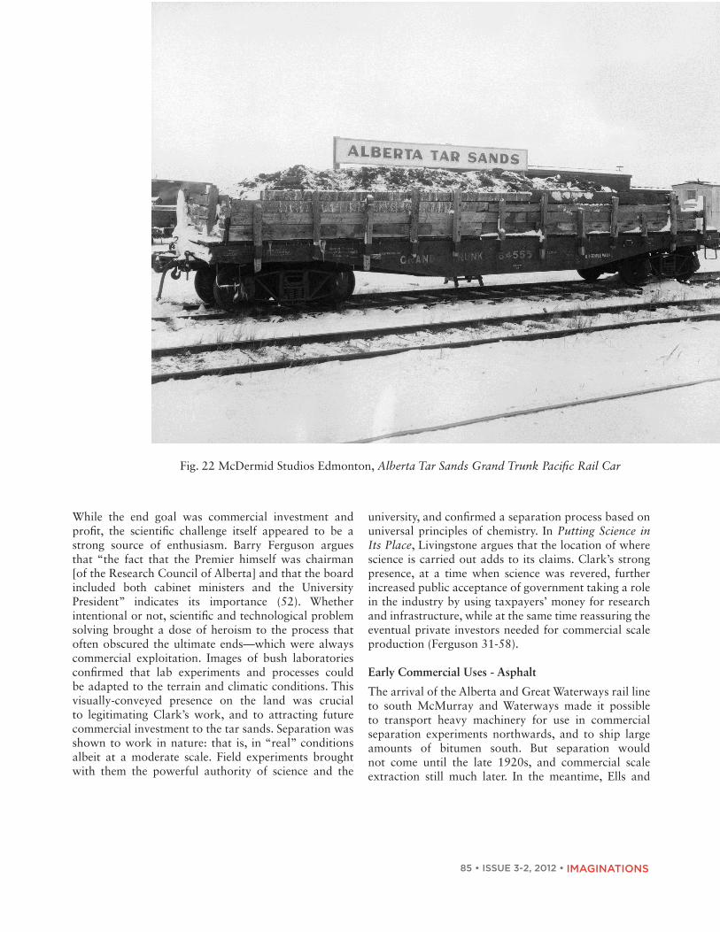
Early Commercial Uses - Asphalt
The arrival of the Alberta and Great Waterways rail line to south McMurray and Waterways made it possible to transport heavy machinery for use in commercial separation experiments northwards, and to ship large amounts of bitumen south. But separation would not come until the late 1920s, and commercial scale extraction still much later. In the meantime, Ells and
Fig. 22 McDermid Studios Edmonton, Alberta Tar Sands Grand Trunk Pacific Rail Car

ImagInIng the tar SandS 1880-1967 and Beyond
Fig. 23 Robert Fitzsimmons, Experimental Pavement Laid with Alberta Bituminous Sand under Direction of Mines Branch, Department of Mines.
Fig. 24 Sidney Ells, Walkways at Jasper Park Lodge Surfaced with Bituminous Sand, Jasper, Alberta.

87 • ISSUE 3-2, 2012 • IMAGINATIONS
gISmondI and davIdSon
Fig. 25 Robert Fitzsimmons, Early Process of Liquefying Bitumen
Fig. 26. Robert Fitzsimmons, International Bitumen Company Limited. Unidentified men using early process in liquifying bitumen.

• ISSUE 3-2, 2012 • 88IMAGINATIONS
ImagInIng the tar SandS 1880-1967 and Beyond
Fig. 27 Robert C. Fitzsimmons, Tar Sands Building Edmonton; View of Exterior of Building Located at 5338-126 Avenue in Edmonton, Alberta.
Fig. 28 Mackenzie Air Service, Aerial View Looking North of Abasand Oils Ltd.,Horse River, Fort McMurray, Alta.

89 • ISSUE 3-2, 2012 • IMAGINATIONS
gISmondI and davIdSon
Clark and both governments were under pressure to demonstrate return on public investment in science and infrastructure.
A number of high profile experiments took place. Ells, on behalf of the federal Department of Mines, describes packing tar sands by dog or Aboriginal and Métis labour tracking scows south on the Athabasca river (Fig. 21), and later by train (Fig. 22) to pave roads and sidewalks on Jasper Avenue in the commercial heart of the capital in Edmonton (Fig. 23), surface approaches to the new Alberta Legislature (see the Alberta legislature paving image in Hunt 347), and to pave approaches to Jasper Park Lodge, a federal landscape (Fig. 24). In its natural state, barely reworked, bituminous sands proved a useable surface.
Billboards that announced train cars of tar sands in Edmonton or its use in federal government paving experiments, no doubt somewhat justified the public investment in mapping, research, and the rail line to McMurray. And high profile ‘experiments’ at the Alberta Legislature and at the federally controlled Jasper Park Lodge symbolically linked each competing level of government to the resources future. The Dominion of Canada would control the Athabasca tar sands region for the Crown until Alberta took control of its natural resources in 1930. Even then, the federal government retained tar sands leases in the McMurray area until 1945, indicating federal priorities for the resource. Both governments would later play a role in co-funding Syncrude in the Lougheed era (1971-1982). The high profile of the experiments resonates with many current corporate and government promotions that extol publicly funded university science and its role in cleaning up the industry. Commercial Scale Experiments
Between the 1930s and the 1940s, two important, privately-funded commercial projects—International Bitumen followed by Abasand Oil—emerged, and failed. Images of these pioneer commercial plants (e.g., Fig. 25 and 26) are sprinkled throughout Canadian history books, invoking pride for the industriousness of commercial pioneers on the tar sands frontier.
Robert Fitzsimmons’ efforts in the 1930s are described as amateur and promotional, but they also caused a contagious “fever of belief” among his followers. Ferguson (85) describes the hypnotic effect of the tar sands on engineers and scientists who worked with Fitzsimmons to try to make separation and production commercially viable, but by 1939, just nine years after construction, the International Bitumen plant, was considered “worthless” and consigned to the dustbins of industrial history.
This photograph of the Fitzsimmons Tar Sands Building under construction in Edmonton (Fig. 27) suggests his optimism and certainly would have added to the public ‘fever’ around the business. Even today, snazzy head offices of tar sands companies have important symbolic value.
The Abasand Oil plant began operations in 1936 (Fig. 28), and was considered a vast improvement over Fitzsimmons’ earlier efforts, constructed under the guidance of Max Ball, an American engineer. The Abasand plant took years to develop and test, and images of it give the impression of a professional and technically sophisticated industrial enterprise. The plant began to produce petroleum products of various kinds in 1941 but was destroyed by fire in November of that year, never reaching its “design capacity of 3000 barrels of bitumen per day,” attaining on average 400 barrels of oil per day in the summer of 1941, although it did prove extraction could be effective (Ferguson 204). Two key factors were common to both of these commercial ventures: “they followed paths beaten by government researchers” like Clark, and they required “advanced technical expertise and large sums of money if commercial development was to be successful” (Ferguson 94).
Faced with fuel shortages during World War II, at a time when Canada produced only five percent of the oil it consumed, the federal government decided to resurrect the failing Abasand project and started reconstruction in 1943. A number of federal investigators carried out a series of studies to identify problems with Ball’s engineering, plant design, and operations, and the technical changes needed to guarantee commercial

• ISSUE 3-2, 2012 • 90IMAGINATIONS
ImagInIng the tar SandS 1880-1967 and Beyond
Fig. 29 George Sherwood Hume, Abasand Plant.
Fig. 30 George Sherwood Hume, Abasand Plant.

91 • ISSUE 3-2, 2012 • IMAGINATIONS
Fig. 31. George Sherwood Hume, Abasand Plant alongside Horse River. Note cribs for waste sands.
Fig. 32 Aerial View of Provincial Government’s Pilot Plant for Extracting Oil from Northern Alberta Tar Sands, Bitumont, Alberta
• ISSUE 3-2, 2012 • 92IMAGINATIONS
ImagInIng the tar SandS 1880-1967 and Beyond
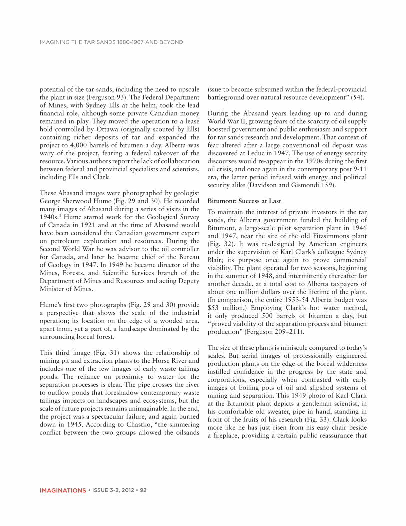
potential of the tar sands, including the need to upscale the plant in size (Ferguson 93). The Federal Department of Mines, with Sydney Ells at the helm, took the lead financial role, although some private Canadian money remained in play. They moved the operation to a lease hold controlled by Ottawa (originally scouted by Ells) containing richer deposits of tar and expanded the project to 4,000 barrels of bitumen a day. Alberta was wary of the project, fearing a federal takeover of the resource. Various authors report the lack of collaboration between federal and provincial specialists and scientists, including Ells and Clark.
These Abasand images were photographed by geologist George Sherwood Hume (Fig. 29 and 30). He recorded many images of Abasand during a series of visits in the 1940s.3 Hume started work for the Geological Survey of Canada in 1921 and at the time of Abasand would have been considered the Canadian government expert on petroleum exploration and resources. During the Second World War he was advisor to the oil controller for Canada, and later he became chief of the Bureau of Geology in 1947. In 1949 he became director of the Mines, Forests, and Scientific Services branch of the Department of Mines and Resources and acting Deputy Minister of Mines.
Hume’s first two photographs (Fig. 29 and 30) provide a perspective that shows the scale of the industrial operation; its location on the edge of a wooded area, apart from, yet a part of, a landscape dominated by the surrounding boreal forest.
This third image (Fig. 31) shows the relationship of mining pit and extraction plants to the Horse River and includes one of the few images of early waste tailings ponds. The reliance on proximity to water for the separation processes is clear. The pipe crosses the river to outflow ponds that foreshadow contemporary waste tailings impacts on landscapes and ecosystems, but the scale of future projects remains unimaginable. In the end, the project was a spectacular failure, and again burned down in 1945. According to Chastko, “the simmering conflict between the two groups allowed the oilsands
issue to become subsumed within the federal-provincial battleground over natural resource development” (54).
During the Abasand years leading up to and during World War II, growing fears of the scarcity of oil supply boosted government and public enthusiasm and support for tar sands research and development. That context of fear altered after a large conventional oil deposit was discovered at Leduc in 1947. The use of energy security discourses would re-appear in the 1970s during the first oil crisis, and once again in the contemporary post 9-11 era, the latter period infused with energy and political security alike (Davidson and Gismondi 159).
Bitumont: Success at Last
To maintain the interest of private investors in the tar sands, the Alberta government funded the building of Bitumont, a large-scale pilot separation plant in 1946 and 1947, near the site of the old Fitzsimmons plant (Fig. 32). It was re-designed by American engineers under the supervision of Karl Clark’s colleague Sydney Blair; its purpose once again to prove commercial viability. The plant operated for two seasons, beginning in the summer of 1948, and intermittently thereafter for another decade, at a total cost to Alberta taxpayers of about one million dollars over the lifetime of the plant. (In comparison, the entire 1953-54 Alberta budget was $53 million.) Employing Clark’s hot water method, it only produced 500 barrels of bitumen a day, but “proved viability of the separation process and bitumen production” (Ferguson 209–211).
The size of these plants is miniscule compared to today’s scales. But aerial images of professionally engineered production plants on the edge of the boreal wilderness instilled confidence in the progress by the state and corporations, especially when contrasted with early images of boiling pots of oil and slipshod systems of mining and separation. This 1949 photo of Karl Clark at the Bitumont plant depicts a gentleman scientist, in his comfortable old sweater, pipe in hand, standing in front of the fruits of his research (Fig. 33). Clark looks more like he has just risen from his easy chair beside a fireplace, providing a certain public reassurance that

93 • ISSUE 3-2, 2012 • IMAGINATIONS
gISmondI and davIdSon
Fig. 33 Dr. Karl Clark who has been in charge of the bituminous sands project since 1920. Bitumont Plant

• ISSUE 3-2, 2012 • 94IMAGINATIONS
ImagInIng the tar SandS 1880-1967 and Beyond
the tar sands have arrived, nature at last tamed by science and industriousness. Clark would attend the sod turning of the Great Canadian Oil Sands in 1965, but died some months before it went into operations. However, in contrast to the reassuring symbol his image represented, Mary Clark Sheppard would later write in her biography of her father that he had a deep respect for nature and, at the end of his life, was saddened to see the scale of mining and processing required at the GCOS plant (89). Nevertheless, today, visitors to Alberta can visit the Alberta Research Council on Dr. Karl Clark Road, Edmonton or the Dr. Karl Clark School in Fort McMurray.
In 1974, the Bitumont site, located 89 km north of Fort McMurray, was designated an Alberta historical site. The statement of historical significance by Alberta Historical Resources staff (“Bitumont Site,” Canada’s Historic Places) affirms:
The heritage value of Bitumont lies in its association with the attempts of the provincial government, private individuals, and oil companies to develop methods of profitably extracting oil from northern Alberta’s tar sands. The hot water separation process pioneered at Bitumont established the economic viability of the tar sands and laid the foundations for future exploitation of this valuable resource. . . . Although Bitumont was abandoned in the late 1950s, the research and technology associated with the site has had an enduring impact upon Alberta’s oil industry. Through the efforts of government agencies and private companies at the site, the Athabasca oil sands were established as a viable commercial endeavour, paving the way for the creation of the massive Suncor and Syncrude oil sands plants.
The approval by the Alberta Government of Bitumont as a Provincial Heritage site did more than preserve some remnants of old industrial buildings; it filled the place with meaning, integrating the story of the industry into the official history of Alberta’s province building. Osborne argues that in the culture of nation-building, certain Canadian geographic landscapes have become
symbolically invested (like civic monuments) with historical meaning, woven into social memory and, in our case, internalized as part of the Alberta identity.
Great Canadian Oil Sands Company 1967
If Karl Clark in his later years expressed alarm at the scale of destruction that ensued, his concern was easily drowned out by the ‘wow’ factor expressed by visuals of the massive machinery dwarfing humans and devouring landscapes (Fig. 34-35). Government and commercial promoters of the tar sands industry in the 1960s and 1970s would celebrate this immensity; images of giant bucket-wheels or draglines became selling features to the public, symbolizing the enormity of challenges overcome. As Berger says, “nothing is accidental in an image,” and visual depictions of the tar sands developments convey scale, perhaps more than any other message (Fig. 34-36). Photo-journalist shots of giant machines worked alongside of discourses about the immensity of the resource, the jobs, and the wealth to keep the scale of destruction at bay, displaced by the wonder of huge technologies. In No Caption Needed, Hariman and Lucaites argue that iconic images like the bucket wheel (Fig. 35-36) represent unspoken civic virtues associated with an historic event (109, 126, 129). With the celebrations surrounding the success of the Great Canadian Oil Sands in Canada’s centennial year (1967), those civic virtues reached the world stage.

95 • ISSUE 3-2, 2012 • IMAGINATIONS
Fig. 34 Heavy Machinery Used at Athabasca Tar Sands.
Fig. 35 Fort McMurray—Great Canadian Tar Sands Project.

• ISSUE 3-2, 2012 • 96IMAGINATIONS
ImagInIng the tar SandS 1880-1967 and Beyond
Fig. 36 Heavy Machinery Used at Athabasca Tar Sands.
A digitization of a film of the opening of the plant in 1967, uploaded to YouTube by Suncor Energy in 2010, captures the pride of those workers who built the GCOS plant, and also records Alberta’s Premier Manning dedicating the new plant “not merely to production of oil but to the continual progress and enrichment of mankind.” GCOS reproduced the bucket-wheel image (Fig. 37) on commemorative medals in 1975 (on the tenth anniversary of public debentures purchased by over 100,000 Albertans to sustain the company), and in 1978 the Government of Canada and Canada Post created a stamp of the Athabasca Tar Sands (Fig. 38), honouring the industry in both official languages.
Fig. 37 Pioneering Energy Together Great Canadian Oil Sands Medallion (1975).

97 • ISSUE 3-2, 2012 • IMAGINATIONS
gISmondI and davIdSon
The Medallions appeared in a blue sleeve with this text: Ten years ago, through the purchase of Great Canadian Debentures, you and more than 100,000 other Albertans joined with The Great Canadian Oil Sands Limited and Sun Oil Company in the creation of the world’s first oil sand mine. You have helped pioneer a very difficult venture that today stands as a milestone in realizing the potential of this unique Alberta resource. In commemoration we have commissioned the special minting of an original medallion: Pioneering Energy Together—1975. We hope that you will value this medallion as a gift of our sincere appreciation of your faith and confidence in the Great Canadian Oil Sands. Your role has been an important one—Your participation Historic.
The wording reminded all Albertans of their connections to the industry as co-founders who had invested both dollars and certain amount of provincial pride.
According to Raento and Brunn stamps act like political messengers; illustrations that take images to a wider audience and perform much like social texts that offer ideological “readings” of a territory or project (145). Often overlooked as part of visual culture, stamps
promote national identity with what Raento and Brunn call “banal nationalism.” In 1978 this stamp added a pleasing aesthetic and artistic quality to the bucketwheel at work, exhibiting enormity yet diminishing perceptions of environmental impacts. Today “Cyrus,” the 850 tonne bucketwheel excavator, has been retired to the outdoor museum at the Oil Sands Discovery Centre in Fort McMurray, “one of the largest land based artifacts in Canada.” While the bucketwheels were surpassed by the giant truck and shovel technologies in the 1990s, Cyrus stands on guard as historical icon, both ‘live’ and on this social media photography website.
Continuities: Visual Threads, Ideological Mainstays
Images of the tar sands differ from the usual oil derricks, drilling rigs, and pump jacks associated with the global oil industry. Tar sands petroculture is non-conventional, just like the non-conventional oil it produces. The industry has had more in common with the massively destructive open-pit mining and smelting cultures of North America than the conventional Alberta oil industry (LeCain). In this paper we introduced a series of historical Athabasca tar sands images to illustrate how representations operated at various stages in the
Fig. 38 Canada Post Corporation, Athabasca Tar Sands Stamp, 1978.
• ISSUE 3-2, 2012 • 98IMAGINATIONS
ImagInIng the tar SandS 1880-1967 and Beyond
growth of this speculative economic and technological undertaking by the Alberta state.
We unearthed traces of scientism and technologism, of masculinity and frontierism, of nature and society dualism, of dominant and excluded gazes, of scale and invisibility, of iconic images and exhibitionary complexes, particular to the social construction of the historical imaginary of the industry well into the late 1980s. Our interest in doing so was neither antiquarian, nor purely historical. As global society faces peak oil and declining rates of supply of conventional oil, non-conventional oil is being looked to solve present and future energy shortages. The ecological, entropic and political contradictions of global expansion into non-conventional oil are the focus of a more complex critique in our work Challenging Legitimacy at the Precipe of Energy Calamity (2011). But what struck us in that work is that many of these older images and traditional messages (i.e. science can solve all problems, and problems in nature can be engineered away) attached to them circulate still today, used in new ways to represent and narrate ‘past and present processes’ of province building and the natural evolution of science, technology and discovery in the industry. Moving out from the archives, these images circulate in corporate and government oil sands publicity and Alberta heritage and culture sites: “the same photograph circulat[ing] in time and space, between historical document and formal experiment, from mass media to curated exhibition” (Gabara 140, 167). Others have become institutionalized in what Bennett called “exhibitionary complexes” like the Oil Sands Discovery Centre (OSDC, established and run by the Alberta Government since 1985), “vehicles for inscribing and broadcasting the messages of power […] throughout society.” At the OSDC, trendy designers integrate hundreds of heritage images into displays of current mining and extraction practices to normalize the step by step growth of the industry, shown twice daily in films like “Pay Dirt – Alberta’s Oil Sands: Centuries in the Making,” a 45-minute “documentary” viewed by thousands of school children and their families annually at the interpretive centre, complete with online teacher’s guide. The scale of environmental consequences, while
acknowledged, is resisted with appeals to that black and white history of corporate and government collaboration to find technological solutions.
Such overt legitimacy work has been called into question in part by a series of contemporary photographic compositions that broke through the controlled corporate and state images available, to offer seldom-seen views of the industrial impacts of tar sands extraction and development. Because of the circulating capacity of the Internet, a global flow of stills and videos of the extent of industrial operations and its ecological impacts now move at different political scales and among different publics—Don van Hout’s personal canoe journey down the Athabasca River in 2007; Louis Helbig’s aerial photography shot from his own airplane as he flew above tar sands operations; the work of Magnum photographers Jonas Bendiksen and Alex Webb; Peter Essick’s National Geographic shoot; or the industrial landscape photography of Edward Burtynsky and his world-renowned study The End of Oil with wide scale images of Alberta’s tar sands operations prominent in the exhibit. Available extensively on social media sites, these and other photographic and moving images inform worldwide critical oppositional discourses.
But the effectiveness of that critique for building a politics or movement of change, despite its global reach, is aggressively resisted by both the Alberta (and now the Canadian federal) state and the global oil industry. Local and national criticism, while at times strong in some progressive sectors, remains muted by a booming Alberta economy, and contemporary discourses about security of supply. One essential element ever present in the multi-layered strategies of supporters of the industry, is this complicated older set of cultural and heritage imaginaries of the industry, which comprise an enduring, if contested, element of subjectivity among Albertans and Canadians, including the social identity of the province. Like Canada’s problematic national identity as a natural resource exporter, such images of heroic extraction linger, acting like ‘‘buried epistemologies” (Braun 3) that confuse and thwart current public thinking about ecological, ethical, and political alternatives to the tar sands.

99 • ISSUE 3-2, 2012 • IMAGINATIONS
gISmondI and davIdSon
Image Notes
Fig. 1 Dowling, G.B.. Geological Survey of Canada; Tar Sands Athabasca River, Alta. 1892. Photograph. PA-038166, 1892. Library and Archives Canada, Ottawa.
Fig. 2. Robson Studio Hammerstein’s Oil Works. Oil and Gas Well, Athabasca District. 1905. Photograph. MIKAN 3524914. Library and Archives Canada, Ottawa.
Fig. 3. Von Hammerstein, Alfred. Tar Sands and Flowing Asphaltum in the Athabasca District. c1908. Photograph. PA-029259. Library and Archives Canada, Ottawa.
Fig. 4. Oil Sand Exposure Near Fort McMurray. N.d. Photograph. PAA 77.178/22. Provincial Archives of Alberta, Edmonton.
Fig. 5. Ells, Roy. Dr. Sidney Ells at Fort McMurray Tar Sands. 1928. Photograph. PAA A12023. Provincial Archives of Alberta, Edmonton.
Fig. 6. Ells, Sidney. Bituminous Sand; Grand Rapids, Athabasca River District. 1913. Photograph. MIKAN 3373021. Library and Archives Canada, Ottawa.
Fig. 7 Ells, Sidney. Terrace Structure, Athabasca River. 1913. Photograph. MIKAN 3373027. Library and Archives Canada, Ottawa.
Fig. 8. Ells, Sidney. Steepbank River. 1923. Photograph. MIKAN3373204. Library and Archives Canada, Ottawa.
Fig. 9. Clark, Karl. Packing dogs with Tar Sands, Ells River. c1925. Photograph. PAA A5560. Provincial Archives of Alberta. Edmonton.
Fig. 10. Spence, H. S. Sydney Ells at Tar Sands Plant. 1931. Photograph. MIKAN 3215356. Library and Archives Canada, Ottawa.
Fig. 11. Ells, Sidney. Working Face of Bituminous Sands. 1927. Photograph. MIKAN 3193674. Library and Archives Canada, Ottawa.
Fig. 12 Oil Sands - ½ Mile North of Fort McMurray. 1921. Photograph. Photo A 3344. Provincial Archives of Alberta, Edmonton.
Fig. 13. Oil Saturated Stones Examined by a Group of Edmonton Business Men. N.d. Photograph. PAA B1067. Provincial Archives of Alberta, Edmonton.
Fig. 14. Fitzsimmons, Robert. Unidentified Man Checking out a Surface Pool of Bitumen. N.d. Photograph. PAA A. 3381. Provincial Archives of Alberta, Edmonton.
Fig. 15 Group Examining Tar Sands, Fort McMurray, Alberta. 1927. Photograph. PD 356-311. Glenbow Archives, Calgary.
Fig. 16 Caley, Rutherford. Man Looking at Oil Flowing Freely from Tar Sands Exposed to Heat of Sun. N.d. Photograph. A12182 Provincial Archives of Alberta, Edmonton.
Fig. 17 Diver, Daniel. Interior of Shack with Sample of Tar Sands and Extractions. Fort McMurray. 1920. Photograph. NA-1142-6. Glenbow Archives, Calgary.
Fig. 18. McDermid Studios Edmonton. Dr. Karl Clark, University of Alberta, Tar Sands Department. 1929. Photograph. ND-3-4596c. Glenbow Archives, Calgary.
Fig. 19 Pasternack, D. S. Oil Sands Extraction Plants- Edmonton Dunvegan Yards. Provincial Archives of Alberta, Edmonton. Photograph. A11233, 1924-25).
Fig. 20 Pasternack, D. S. Oil Extraction Plant - Clearwater River Plant. c1930. Photograph. PAA 11223. Provincial Archives of Alberta, Edmonton.Fig. 21 Ells, Sidney. Men Carrying Sacks of Bituminous Sands as Shipment Passes Cascade Rapids, Athabasca River, Alberta. 1923. Photograph. MIKAN 3524747. Library and Archives Canada, Ottawa.

• ISSUE 3-2, 2012 • 100IMAGINATIONS
ImagInIng the tar SandS 1880-1967 and Beyond
Fig. 22 McDermid Studios Edmonton. Alberta Tar Sands Grand Trunk Pacific Rail Car. 1924. Photograph. ND-3-2684. Glenbow Archives, Calgary.
Fig. 23 Fitzsimmons, Robert. Experimental Pavement Laid with Alberta Bituminous Sand under Direction of Mines Branch, Department of Mines. c1930. Photograph. A3399. Provincial Archives of Alberta, Edmonton.
Fig. 24 Ells, Sidney. Walkways at Jasper Park Lodge Surfaced with Bituminous Sand, Jasper, Alberta. 1927. Photograph. MIKAN 3524748. Library and Archives Canada, Ottawa.
Fig. 25 Fitzsimmons, Robert. Early Process of Liquefying Bitumen. 1930. Photograph. PAA A3384. Provincial Archives of Alberta, Edmonton.
Fig. 26. Fitzsimmons, Robert. International Bitumen Company Limited. 1930. Photograph. PAA A3383. Provincial Archives of Alberta, Edmonton.
Fig. 27 Fitzsimmons, Robert. Tar Sands Building Edmonton; View of Exterior of Building Located at 5338-126 Avenue in Edmonton, Alberta. N.d. Photograph. PAA A3364. Provincial Archives of Alberta, Edmonton.
Fig. 28 Mackenzie Air Service. Aerial view looking north of Abasand Oils Ltd., Horse River, Fort McMurray, Alta. November, 1936. Photograph. MIKAN 3524916. Library and Archives Canada, Ottawa.
Fig. 29 Hume, George Sherwood. Abasand Plant. 1944/1945. Photograph. PA-574-1074. Glenbow Archives, Calgary.
Fig. 30 Hume, George Sherwood. Abasand Plant 1944/1945. Photograph. PA 574-1072. Glenbow Archives, Calgary.
Fig. 31. Hume, George Sherwood. Abasand Plant
alongside Horse River. 1944/45. Photograph. PA 574-1073. Glenbow Archives, Calgary.
Fig. 32 Aerial View of Provincial Government’s Pilot Plant for Extracting Oil from Northern Alberta Tar Sands, Bitumont, Alberta. c1949-1950. Photograph. Originally published in the Calgary Herald, February 12, 1951. PA-1599-451-2. Glenbow Archives, Calgary.
Fig. 33 Dr. Karl Clark Who Has Been in Charge of the Bituminous Sands Project Since 1920. Bitumont Plant. 1949. Photograph. PA 410.3. Provincial Archives of Alberta, Edmonton.
Fig. 34. Heavy Machinery Used at Athabasca Tar Sands. 1967. Photograph. s-229-21a.tif Glenbow Museum, Calgary.
Fig. 35 Fort McMurray—Great Canadian Tar Sands Project. June 27, 1967. Photograph. PAA J99. Provincial Archives of Alberta, Edmonton.
Fig. 36 Heavy Machinery Used at Athabasca Tar Sands. 1967. Photograph. S-220-21. Glenbow Archives, Calgary.
Fig. 37 Pioneering Energy Together Great Canadian Oil Sands Medallion (1975). Photograph. Gateway Coin Auctions. N.d. Web. August 22, 2012.
Fig. 38 Canada Post Corporation. Athabasca Tar Sands Stamp. 1978. MIKAN 2218481. Library and Archives Canada, Ottawa.
Works Cited
Bendiksen, Jonas. “Fort McMurray 2007 Album.” Magnum Photography. 2007. Web. August 20, 2012.
Bennett, Tony. “The Exhibitionary Complex.” Culture/Power/History: A Reader in Contemporary Social Theory. Ed. Nicholas B. Dirks, Geoff Eley, and

101 • ISSUE 3-2, 2012 • IMAGINATIONS
gISmondI and davIdSon
Sherry B. Ortner. Princeton: Princeton University, 1994. Print.
“Bitumont site.” Canada’s Historic Places: A Federal, Provincial and Territorial Collaboration. Parks Canada. n.d. Web. March 3, 2012. <http://www.historicplaces.ca/en/rep-reg/place-lieu.aspx?id=4998>.
Braun, Bruce. “Buried Epistemologies: The Politics Of Nature In (Post) Colonial British Columbia.” Annals of the Association of American Geographers 87.1 (1997): 3-31. Print.
Burke, Peter. Eyewitnessing: The Uses of Images as Historical Evidence. NY: Cornell University, 2001. Print.
Burtynsky, Edward. The End of Oil. Edward Burtynsky Photographic Works. n.d. Web. August 20, 2012.
Caley, John. “Memorial to George Sherwood Hume 1893-1965.” Geological Society of America Bulletin 77:9 (September 1966): 179-184. Print.
Castree, Noel, and Bruce Braun. “Constructing Rural Natures.” Handbook of Rural Studies. Ed. Paul J. Cloke, Terry Marsden, and Patrick H. Mooney. London: Sage, 2006. Print
Chastko, Paul. Developing Alberta’s Oil Sands from Karl Clark to Kyoto. Calgary: University of Calgary, 2004. Print.
Comfort, Darlene. The Abasand Fiasco: The Rise and Fall of a Brave Pioneer Oil Sands Extraction Plant. Ed. Peter G. Duffy. Edmonton: Friesen Printers, 1980. Print.
Davidson, Debra J., and Mike Gismondi. Challenging Legitimacy at the Precipice of Energy Calamity. New York: Springer Press, 2011. Print.
Deans Cameron, Agnes. The New North. Being Some Account of a Woman’s Journey through Canada to the Arctic. New York: Appleton, 1909. Print.
Ells, Sidney C. Recollections of the Development of the Athabasca Oil Sands. Ottawa: Department of Mines and Technical Surveys, Mines Branch, 1962. Print.
Essick, Peter. National Geographic Oil Sands Images. Aurora Photos. 2009. Web. August 20, 2012.
Ferguson, Barry G. Athabasca Oil Sands: Northern Resource Exploration 1875-1951. Regina, SK: Canadian Plains Research Center, 1985. Print.
Gabara, Esther. “Recycled Photographs: Moving Still Images of Mexico City, 1950-2000.” Photography and Writing in Latin America: Double Exposures. Ed. Marcy E. Schwartz and Mary Beth Tierney-Tello. Albuquerque: University of New Mexico, 2006. Print.
Hajer, Maarten, and Wytske Versteeg. “A Decade of Discourse Analysis of Environmental Politics: Achievements, Challenges, Perspectives.” Journal of Environmental Policy & Planning 7.3 (2005): 175-84. Print.
Hariman, Robert, and John Louis Lucaites. No Caption Needed: Iconic Photographs, Public Culture, and Liberal Democracy. Chicago: University of Chicago, 2007. Print.
Helbig, Louis. Beautiful Destruction. n.d. Web. August 20, 2012. <http://www.beautifuldestruction.ca>.
“Honoured CPHFS Members.” Canadian Petroleum Hall of Fame. 2011. Web. August 20, 2012.
Huber, Matthew. “Energizing Historical Materialism: Fossil Fuels, Space and the Capitalist Mode of Production.” Geoforum 40 (2008): 105-115. Print.
Hunt, Joyce. Local Push—Global Pull: The Untold History of the Athabaska Oil Sands. 1900-1930. Calgary: Push Pull Ltd, 2011. Print.
LeCain, Timothy J. Mass Destruction: The Men and Giant Mines that Wired America and Scarred the Planet. New Brunswick, NJ: Rutgers University, 2009. Print.

• ISSUE 3-2, 2012 • 102IMAGINATIONS
ImagInIng the tar SandS 1880-1967 and Beyond
Livingstone, David N. Putting Science in Its Place: Geographies of Scientific Knowledge. Chicago: University of Chicago, 2003. Print.
Mitchell, W.J. Thomas. Ed. Landscape and Power. Chicago: University of Chicago, 1994. Print.
Mraz, J. Nacho Lopéz, Mexican Photographer. Minneapolis-London: University of Minnesota Press. 2003. Print.
Osborne, Brian S. “Landscapes, Memory, Monuments, and Commemoration: Putting Identity in Its Place.” Library and Archives of Canada. 2001. Web. August 20, 2012. <http://epe.lac-bac.gc.ca/100/200/300/citizenship_and_immigration_canada_metropolis/landscapes_memory-e/putinden.pdf>.
“Pay Dirt: Alberta’s Oil Sands: Centuries in the Making.” Pay Dirt Pictures. 2005. Web. August 20, 2012.
Pratt, Larry, and Matina Karvellas. “Nature and Nation: Herder, Myth and Cultural Nationalism in Canada.” National History 1.1 (1997): 58-77. Print.
Richards, John, and Larry Pratt. Prairie Capitalism: Power and Influence in the New West. Toronto: McClelland and Stewart, 1979. Print.
Raento, Pauliina and Stanley D. Brunn. “Visualizing Finland: Postage Stamps as Political Messengers.” Geografiska Annaler Series B: Human Geography 87.2 (2005): 145-164. Print.
Sandlos, John. “Landscaping Desire: Poetics, Politics in the Early Biological Surveys of the Canadian North.” Space & Culture 6.4 (2003): 394-414. Print.
Schwartz, Joan M. “More Than ‘Competent Descriptions of an Intractably Empty Landscape’: A Strategy for Critical Engagement with Historical Photographs.” Historical Geography 31 (2003): 105-30. Print.
Schwartz, Joan M. “Photographs from The Edge Of Empire.” Cultural Geography in Practice. Ed. A.
Blunt, P. Gruffudd, J. May, M. Ogborn, D. Pinder, D. London: Arnold, 2003: 154-171. Print.
Schwartz, Joan M. “Photographic Reflections: Nature, Landscape, and Environment.” Environmental History 12 (2007): 966-93. Print.
Scott, James. Seeing Like a State. How Certain Schemes to Improve the Human Condition Have Failed. New Haven: Yale University Press, 1999. Print.
Sheppard, Mary Clark. Oil Sands Scientist: The Letters of Karl A. Clark. Edmonton: University of Alberta, 1989. Print.
Webb, Alex. Fort McMurray Oilsands Album. Magnum Photos. 2005. Web. August 20, 2012.
Zaslow, Morris. The Opening of the Canadian North 1870-1914. Toronto: McClelland and Stewart, 1971. Print.
Zeller, Suzanne. Inventing Canada: Early Victorian Science and the Idea of a Transcontinental Nation. Toronto: University of Toronto, 1987. Print.
(Endnotes)
1. This paper advances on arguments from chapters 3 and 4 of Debra J. Davidson and Mike Gismondi, Chal-

103 • ISSUE 3-2, 2012 • IMAGINATIONS
gISmondI and davIdSon
Gismondi, Michael: Mike Gismondi is Professor of sociology and global studies at Athabasca University. His areas of teaching and research include the sociology of power and environmental issues. Together with Debra J. Davidson, with whom he shares an interest in interdisciplinary thinking about the transition to sustainability, he has co-authored Challenging Legitimacy at the Precipice of Energy Calamity (2011). This is one of very few sociological analyses of the Alberta tar sands.
Gismondi, Michael : Michael Gismondi est professeur de sociologie et d’études mondiales à l’Université de l’Athabasca où il enseigne les sujets principaux de ses recherches : la sociologie du pouvoir et les questions environnementales. Il partage avec Debra J. Davidson un intérêt pour la réflexion interdisciplinaire sur la mise en place et la mise en valeur du développement durable. Cet intérêt commun a mené à l’œuvre collaborative Challenging Legitimacy at the Precipice of Energy Calamity (Springer, 2011) qui constitue une des rares analyses sociologiques des sables bitumineux de l’Alberta.
Davidson, Debra J.: Debra J. Davidson is Associate Professor of environmental sociology in the Department of Resource Economics and Environmental Sociology at University of Alberta. Her areas of teaching and research include the social dimensions of energy and climate change. Together with Michael Gismondi, with whom she shares an interest in interdisciplinary thinking about the transition to sustainability, she has co-authored Challenging Legitimacy at the Precipice of Energy Calamity (2011). This is one of very few sociological analyses of the Alberta tar sands.
Davidson, Debra J. : Debra J. Davidson est professeure agrégée de sociologie environnementale dans le département de sociologie environnementale et d’économie des ressources naturelles à l’Université de l’Alberta. Les dimensions de l’énergie et des changements climatiques sont au cœur de son enseignement et de ses recherches. Elle partage avec Michael Gismondi un intérêt pour la réflexion interdisciplinaire sur la mise en place et la mise en valeur du développement durable. Cet intérêt commun a mené à l’œuvre collaborative Challenging Legitimacy at the Precipice of Energy Calamity (Springer, 2011) qui constitue une des rares analyses sociologiques des sables bitumineux de l’Alberta.
Copyright Mike Gismondi and Debra Davidson. This article is licensed under a Creative Commons 3.0 License although certain works referenced herein may be separately licensed, or the author has exercised their right to fair dealing under the Canadian Copyright Act.