imd - investigation of alternative sitesassets.hs2.org.uk/sites/default/files/inserts/hs2 arup...
TRANSCRIPT
High Speed 2 Limited
High Speed 2
London to West Midlands
IMD - Investigation of Alternative Sites
January 2012


High Speed 2 Limited High Speed 2
IMD - Investigation of Alternative Sites
Contents
Page
1 Introduction 1
1.1 The Purpose of this Report 1
1.2 The Layout and Content of this Report 1
2 Public Consultation 2
2.1 Consultation responses 2
3 Area to be investigated 3
3.1 Suitable land sites 3
3.2 Suitable rail connections 3
3.3 Conclusion 4
4 Site Identification 5
4.1 Site 1 6
4.2 Site 2 9
4.3 Site 3 12
4.4 Site 4 15
4.5 Site 5 17
4.6 Site 6 20
5 Conclusion 23
References
Infrastructure Maintenance Depot (IMD), HS2-ARP-07-RP-RW-00001, Issue 4.0,
dated 23/3/11.
Figures
Figure 1 - Area for evaluation of an alternative IMD site
Figure 2 - Possible sites identified for an IMD
Figure 3 - Site 1 location
Figure 4 - Site 2 location
Figure 5 - Site 3 location
Figure 6 - Site 4 location
Figure 7 - Site 5 location
Figure 8 - Site 6 location

High Speed 2 Limited High Speed 2
IMD - Investigation of Alternative Sites
Photographs
Photograph 1 - General site layout
Photograph 2 - Buildings adjoining rail line behind hedge on left
Photograph 3 - Quainton Road railway centre with site on the right hand side
Photograph 4 - Site looking from Waddesdon showing slope from the sewage works towards the railway
Photograph 5 - Agricultural land adjacent to the railway (behind the right hand hedge)
Photograph 6 - Former Waddesdon Station site
Photograph 7 - Land sloping down from the railway on the right, showing the relatively open nature of the site
Photograph 8 - Site looking across open fields to the railway line
Photograph 9 - Looking towards farmhouse with site on left
Photograph 10 - Aerial view of approximate land use (taken from Google Earth)
High Speed 2 Limited High Speed 2
IMD - Investigation of Alternative Sites
Page 1 of 23
1 Introduction
1.1 The Purpose of this Report
A report setting out the preferred location for the Infrastructure Maintenance Depot (IMD) for the HS2 London to West-Midlands route section was prepared and issued in July 2010. It recommended a site between Calvert and Steeple Claydon, within the chord line linking the Oxford – Bletchley Network Rail line and HS2. The site was selected after consideration of other sites in the vicinity.
The IMD is designed to provide the facilities for railborne maintenance equipment, required to service track, signalling and overhead line equipment along the entire HS2 line of route. It was determined that the Oxford – Bletchley East West Rail line (EWR) provided the best access to and from the national rail network, essential for the delivery of track materials to the depot. This in turn led to consideration of sites in the immediate vicinity of the intersection of the two routes.
The essential criteria for site selection were summarised as consisting of:
Level site
Straight site
Site length of approximately 1 km
Capability to connect with both HS2 and the EWR
Minimisation of environmental impact by avoiding:
Immediate proximity to built up areas
Use of flood plain
Areas of high visual impact
This report has been commissioned by HS2 Ltd to examine whether there are alternative sites that might be suitable for consideration for use as an IMD, using the same selection criteria as were applied in the original study. Our work has focussed on sites near to Aylesbury.
1.2 The Layout and Content of this Report
The report is laid out as follows:
Chapter 1, this chapter is introductory;
Chapter 2 briefly highlights the issues raised at consultation;
Chapter 3 describes the area to be investigated as an alternative the current location at Calvert;
Chapter 4 lists the individual areas assessed and discusses their positive and negative attributes as an alternative IMD site;
Chapter 5 contains the conclusions.

High Speed 2 Limited High Speed 2
IMD - Investigation of Alternative Sites
Page 2 of 23
2 Public Consultation
2.1 Consultation responses
Following consultation, Arup was asked by HS2 Ltd to investigate alternative locations for the IMD. Comments from consultation on the IMD focussed largely on issues around road access, workforce availability, and night time working. Road Access:
With regard to road access, concern was expressed that the local road network around the IMD site at Calvert was not suited to the number of vehicles that would require access to the site. Workforce Availability:
With little unemployment in the local area, it was suggested that the jobs created by the depot would be filled from elsewhere rather than by members of the local population. Night time Working:
Concern was also expressed that with night time working at the site, local residents, particularly from Steeple Claydon, would be impacted.”
High Speed 2 Limited High Speed 2
IMD - Investigation of Alternative Sites
Page 3 of 23
3 Area to be investigated
Consideration of the area to be investigated as a potential alternative IMD site defined the following limits to the location of potentially suitable sites.
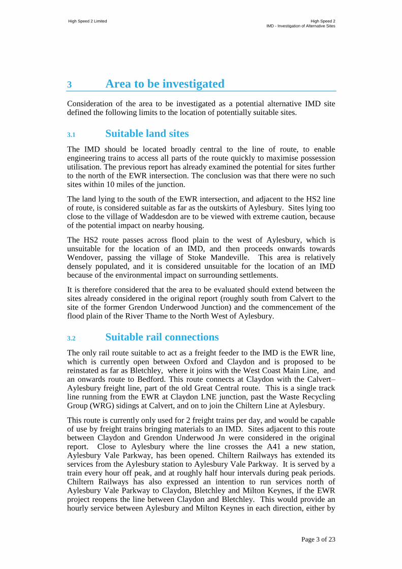
3.1 Suitable land sites
The IMD should be located broadly central to the line of route, to enable engineering trains to access all parts of the route quickly to maximise possession utilisation. The previous report has already examined the potential for sites further to the north of the EWR intersection. The conclusion was that there were no such sites within 10 miles of the junction.
The land lying to the south of the EWR intersection, and adjacent to the HS2 line of route, is considered suitable as far as the outskirts of Aylesbury. Sites lying too close to the village of Waddesdon are to be viewed with extreme caution, because of the potential impact on nearby housing.
The HS2 route passes across flood plain to the west of Aylesbury, which is unsuitable for the location of an IMD, and then proceeds onwards towards Wendover, passing the village of Stoke Mandeville. This area is relatively densely populated, and it is considered unsuitable for the location of an IMD because of the environmental impact on surrounding settlements.
It is therefore considered that the area to be evaluated should extend between the sites already considered in the original report (roughly south from Calvert to the site of the former Grendon Underwood Junction) and the commencement of the flood plain of the River Thame to the North West of Aylesbury.
3.2 Suitable rail connections
The only rail route suitable to act as a freight feeder to the IMD is the EWR line, which is currently open between Oxford and Claydon and is proposed to be reinstated as far as Bletchley, where it joins with the West Coast Main Line, and an onwards route to Bedford. This route connects at Claydon with the Calvert– Aylesbury freight line, part of the old Great Central route. This is a single track line running from the EWR at Claydon LNE junction, past the Waste Recycling Group (WRG) sidings at Calvert, and on to join the Chiltern Line at Aylesbury.
This route is currently only used for 2 freight trains per day, and would be capable of use by freight trains bringing materials to an IMD. Sites adjacent to this route between Claydon and Grendon Underwood Jn were considered in the original report. Close to Aylesbury where the line crosses the A41 a new station, Aylesbury Vale Parkway, has been opened. Chiltern Railways has extended its services from the Aylesbury station to Aylesbury Vale Parkway. It is served by a train every hour off peak, and at roughly half hour intervals during peak periods. Chiltern Railways has also expressed an intention to run services north of Aylesbury Vale Parkway to Claydon, Bletchley and Milton Keynes, if the EWR project reopens the line between Claydon and Bletchley. This would provide an hourly service between Aylesbury and Milton Keynes in each direction, either by

High Speed 2 Limited High Speed 2
IMD - Investigation of Alternative Sites
Page 4 of 23
extending the existing service to Aylesbury Vale Parkway, or possibly by running an additional service.
In either case running time between Aylesbury and Claydon LNE Jn on the single line would be about 15 minutes, and this would occupy the line for 50% of its available capacity. It is unlikely that the trains would cross at either end of the single line, and therefore track occupation by the passenger trains might preclude daytime freight access, unless additional capacity were installed by the creation of a loop somewhere along the line. Depending on the site of the IMD, this loop might also be used as reception sidings for the depot. Given that the route was formerly double track, and that south of Quainton Road the HS2 route diverges from it, it is assumed that there is potential to carry out works to increase capacity of these were found to be necessary.
South of Aylesbury both the main Chiltern route to Marylebone via Amersham, and the alternative single line route to Princes Risborough are already intensively used by passenger trains, and there is little or no spare capacity to run regular daytime freight trains. For this reason it is not considered feasible to investigate an IMD site south of Aylesbury.
The conclusion is that sites between Grendon Underwood Jn and Aylesbury Vale Parkway should be considered for an IMD, but those sites further south could not be served by daytime freight trains.
3.3 Conclusion
For both land use and rail servicing aspects, it is considered that only the section between Grendon Underwood Jn and Aylesbury Vale Parkway should be considered for an alternative IMD site.
Figure 1 - Area for evaluation of an alternative IMD site
High Speed 2 Limited High Speed 2
IMD - Investigation of Alternative Sites
Page 5 of 23
4 Site Identification
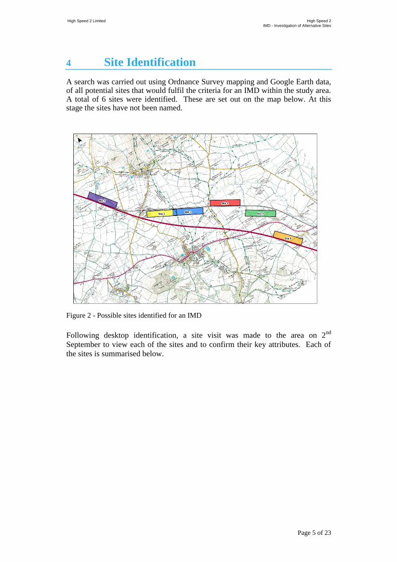
A search was carried out using Ordnance Survey mapping and Google Earth data, of all potential sites that would fulfil the criteria for an IMD within the study area. A total of 6 sites were identified. These are set out on the map below. At this stage the sites have not been named.
Figure 2 - Possible sites identified for an IMD
Following desktop identification, a site visit was made to the area on 2nd
September to view each of the sites and to confirm their key attributes. Each of
the sites is summarised below.

High Speed 2 Limited High Speed 2
IMD - Investigation of Alternative Sites
Page 6 of 23
4.1 Site 1
Figure 3 - Site 1 location
4.1.1 Description
The site lies to the North of the Great Central Aylesbury – Claydon Junction line and to the north of the former Quainton Road railway station, adjacent to the former junction of the branch to Verney Junction. The site is predominantly agricultural land split by the dismantled railway. It is relatively flat and is not overlooked by housing, though there are properties to the west of the HS2 route. There is access to the site from an unclassified road running towards Quainton village.
At this point HS2 and the Claydon – Aylesbury line run directly alongside each other, but diverge immediately to the south of the site.

High Speed 2 Limited High Speed 2
IMD - Investigation of Alternative Sites
Page 7 of 23
Photograph 1 - General site layout
4.1.2 Advantages
Level site
The site is not overlooked by any significant residential areas
The site is long enough to accommodate a depot
The site has direct access from the Claydon – Aylesbury line
4.1.3 Disadvantages
The site is on the opposite side of the tracks from HS2
At this point HS2 and the Network Rail line run directly alongside each other and there is not room to site running loops to interface between them
Photograph 2 - Buildings adjoining rail line behind hedge on left

High Speed 2 Limited High Speed 2
IMD - Investigation of Alternative Sites
Page 8 of 23
The road access to the site is poor, via an unclassified from Waddesdon village
4.1.4 Conclusions
While the site has space for an IMD, and could be connected with HS2, it essentially has the same road access issues as the Claydon site. It therefore offers no significant advantage over the site already identified. Access to HS2 would be over the Network Rail line, and would require the installation of loop lines to the south as the two routes run in the same corridor to the north to minimise impact.
The conclusion is that this option should not be developed.

High Speed 2 Limited High Speed 2
IMD - Investigation of Alternative Sites
Page 9 of 23
4.2 Site 2
4.2.1 Description
The site lies to the South of the Aylesbury – Claydon Junction line and in the
angle between it and the HS2 alignment. It is adjacent to (or on) part of the
Quainton Road railway centre site. It is not overlooked by housing and is
relatively remote from Waddesdon village. The railway here is on a considerable
gradient (falling towards Aylesbury at 1 in 151) which makes installing double
ended access impossible. The site is bounded to the South by a sewage treatment
works.
Figure 4 - Site 2 location

High Speed 2 Limited High Speed 2
IMD - Investigation of Alternative Sites
Page 10 of 23
Photograph 3 - Quainton Road railway centre with site on the right hand side
Photograph 4 - Site looking from Waddesdon showing slope from the sewage works towards the railway
4.2.2 Advantages
The site has direct access from the Claydon – Aylesbury line
The site is long enough to accommodate a depot
Capability to connect with both HS2 and EWR
The site is not overlooked by any significant residential areas
4.2.3 Disadvantages
The site is not flat, and falls considerably towards Aylesbury

High Speed 2 Limited High Speed 2
IMD - Investigation of Alternative Sites
Page 11 of 23
The topography is relatively poor and there is a high outcrop approximately at the location of the sewage works
There is no road access to the site and any access would have to come from the Quainton Road site
4.2.4 Conclusions
While the site has space for an IMD, the land levels are not suitable for a large flat site.
Our conclusion is that this site is not suitable for an IMD.

High Speed 2 Limited High Speed 2
IMD - Investigation of Alternative Sites
Page 12 of 23
4.3 Site 3
4.3.1 Description
The site is an extension of the former Waddesdon station site, on the south west of
the railway and in between the Network Rail line and HS2.The site is bounded to
the east by Blackgrove Road which provides relatively direct access to the A41 on
the Aylesbury side of Waddesdon.
The land is level in the immediate vicinity of the site, though as it shares land at
the north with the end of site 2 starts to rise towards the north. There is probably
not enough level length to provide 1 km of sidings, and the houses to the rear of
Waddesdon village overlook the site
Figure 5 - Site 3 location

High Speed 2 Limited High Speed 2
IMD - Investigation of Alternative Sites
Page 13 of 23
Photograph 5 - Agricultural land adjacent to the railway (behind the right hand hedge)
Photograph 6 - Former Waddesdon Station site
4.3.2 Advantages
Level site
Capability to connect with both HS2 and EWR
Good road access to the A41
Some use of former railway facilities at the former station site
4.3.3 Disadvantages
The site is close to Waddesdon and areas of high visual impact and would be more visible than Site 3 because of the topography
The site is not long enough to provide the required 1km of siding accommodation

High Speed 2 Limited High Speed 2
IMD - Investigation of Alternative Sites
Page 14 of 23
4.3.4 Conclusions
The proximity of the site to Waddesdon village (albeit on the other side of the line from HS2), and the lack of suitable length, mean that this site is not considered suitable to locate an IMD on.
The conclusion is that this option should not be developed.

High Speed 2 Limited High Speed 2
IMD - Investigation of Alternative Sites
Page 15 of 23
4.4 Site 4
4.4.1 Description
The site lies to the North of the Aylesbury – Claydon Junction line, bounded by
Blackgrove Road to the west, and on the other side of the track to Site 3. It is
relatively flat, and clear of the flood plain, on agricultural land. Its position makes
it relatively visible to the surrounding area. It is not directly overlooked by
housing, though would be visible to settlements further away.
Road access is via Blackgrove Road, and direct to the A41 on the Aylesbury side of Waddesdon.
Access to HS2 would be across the Network Rail line, and via a connecting track of some distance, as the routes are diverging at this point.
Figure 6 - Site 4 location

High Speed 2 Limited High Speed 2
IMD - Investigation of Alternative Sites
Page 16 of 23
Photograph 7 - Land sloping down from the railway on the right, showing the relatively open nature of the site
4.4.2 Advantages
The site could be made level, and lies alongside the Network Rail line
The site is long enough to accommodate a depot
The site is not directly overlooked by any significant residential areas
4.4.3 Disadvantages
The site is on the opposite side of the tracks from HS2 and connections would be difficult to provide
The site would be relatively conspicuous from a distance
4.4.4 Conclusions
The site has space and topography for an IMD, and reasonable road access. It does however lie in a sensitive area adjacent to a water course, which would make it visible to the surrounding landscape. Access between the site and HS2 would be complicated by the distance between the two routes, and the fact that it lies on the wrong side of the Network Rail line. The land on the other side of the tracks rises steeply and cannot be used as an IMD site.
The conclusion is that this option should not be developed.
High Speed 2 Limited High Speed 2
IMD - Investigation of Alternative Sites
Page 17 of 23
4.5 Site 5
4.5.1 Description
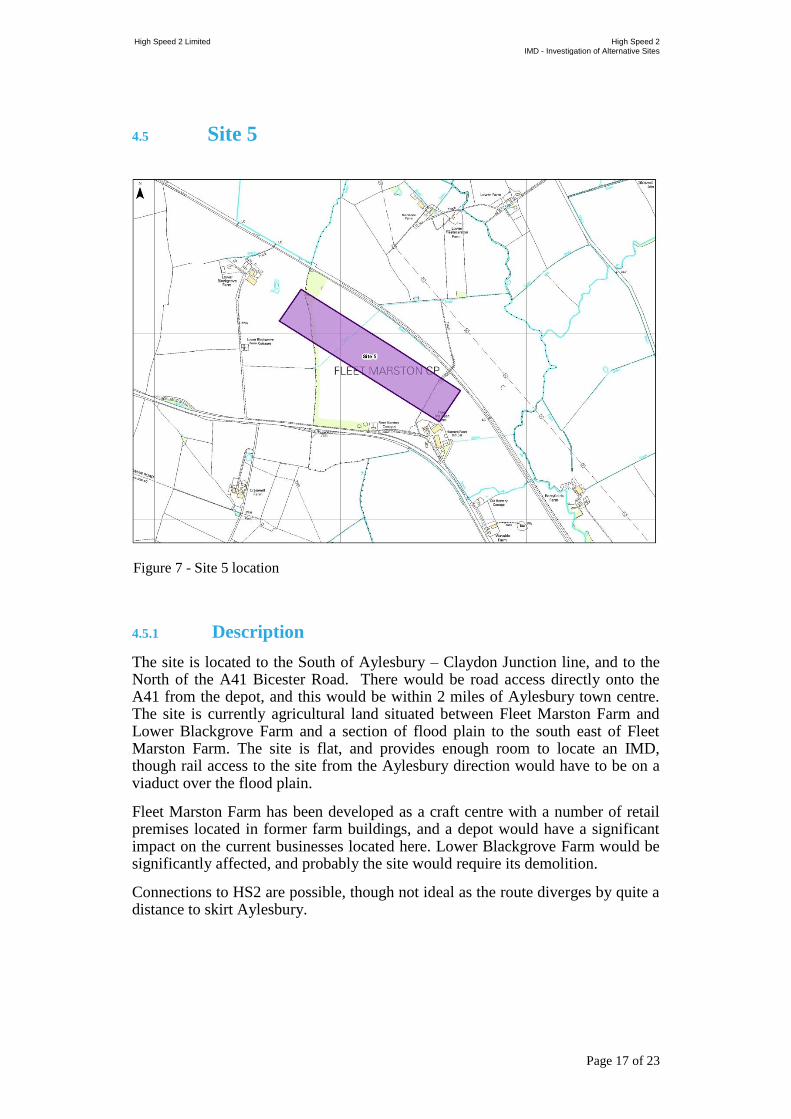
The site is located to the South of Aylesbury – Claydon Junction line, and to the North of the A41 Bicester Road. There would be road access directly onto the A41 from the depot, and this would be within 2 miles of Aylesbury town centre. The site is currently agricultural land situated between Fleet Marston Farm and Lower Blackgrove Farm and a section of flood plain to the south east of Fleet Marston Farm. The site is flat, and provides enough room to locate an IMD, though rail access to the site from the Aylesbury direction would have to be on a viaduct over the flood plain.
Fleet Marston Farm has been developed as a craft centre with a number of retail premises located in former farm buildings, and a depot would have a significant impact on the current businesses located here. Lower Blackgrove Farm would be significantly affected, and probably the site would require its demolition.
Connections to HS2 are possible, though not ideal as the route diverges by quite a distance to skirt Aylesbury.
Figure 7 - Site 5 location
High Speed 2 Limited High Speed 2
IMD - Investigation of Alternative Sites
Page 18 of 23
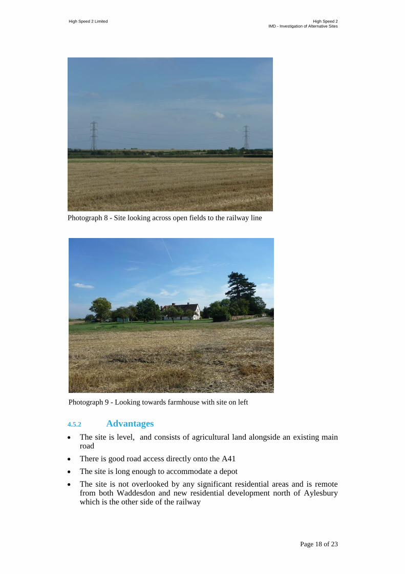
Photograph 8 - Site looking across open fields to the railway line
4.5.2 Advantages
The site is level, and consists of agricultural land alongside an existing main road
There is good road access directly onto the A41
The site is long enough to accommodate a depot
The site is not overlooked by any significant residential areas and is remote from both Waddesdon and new residential development north of Aylesbury which is the other side of the railway
Photograph 9 - Looking towards farmhouse with site on left

High Speed 2 Limited High Speed 2
IMD - Investigation of Alternative Sites
Page 19 of 23
The site can be directly connected to both HS2 and the Aylesbury to Claydon line
4.5.3 Disadvantages
The southern access tracks require to pass over flood plain on a viaduct
There would be a considerable impact on the farm based businesses and dwellings
Access to the HS2 alignment is not ideal but is possible
4.5.4 Conclusions
This site has considerable attraction because of both its proximity to Aylesbury and its good road access. There is a considerable impact on the two farmhouses, but relatively little on surrounding settlements. The site is already bounded by the railway and the main road, and will be further impacted by the HS2 route.
The site is flat and capable of development.
The conclusion is that while this site has some disadvantages, it is certainly capable of development, and fulfils the criteria of proximity to Aylesbury and good road access. It should be taken forward for further consideration, though care must be taken of the impact on the flood plain, and to determine the impact on the surrounding farmhouses. The characteristics of Site 6 below appear to be more suitable for an IMD than this site, and therefore Site 6 should have the initial priority for further feasibility work.

High Speed 2 Limited High Speed 2
IMD - Investigation of Alternative Sites
Page 20 of 23
4.6 Site 6
Figure 8 - Site 6 location
4.6.1 Description
This site lies on the other side of the A41, alongside HS2, but physically remote from the Network Rail Claydon to Aylesbury line. It lies on agricultural land, and is flat. It is relatively well screened from adjacent farmhouses site lies to the North of the Great Central Aylesbury – Claydon Junction line and to the north of the former Quainton Road railway station, adjacent to the former junction of the branch to Verney Junction.
The site is predominantly agricultural land split by the dismantled railway. It is relatively flat and though it is overlooked by some houses, the overall impact of the site is relatively small. One farm complex (Putlowes) would be significantly affected by both the depot and the HS2 route alignment.
National rail access would have to be via a third line laid parallel to HS2 from north of Quainton Road to the site, but this would have the advantage of reducing the track occupation on the single line section to Claydon, and might obviate the need for additional capacity works if the Chiltern service to Milton Keynes were implemented.
Again there would be direct road access to the A41.
No photo is currently available of this site. Instead a Google Earth image is shown to illustrate current land use.

High Speed 2 Limited High Speed 2
IMD - Investigation of Alternative Sites
Page 21 of 23
4.6.2 Advantages
The site is level, and capable of providing at least 1 km of siding length
Good road access provided by the A41
The site is large enough to accommodate an IMD
The site is not overlooked by any significant residential areas, and is relatively well screened from the surrounding area
The site lies directly adjacent to the HS2 route, and can feed directly onto it
Creation of a segregated access route from Quainton Road may address the capacity issues for freight trains accessing the site if an EWR service to Milton Keynes is implemented
There are no flood plain impacts
4.6.3 Disadvantages
There are some impacts on a small number of surrounding houses and farmhouses, though these are already impacted by the HS2 alignment. One farm complex is very significantly affected
There is no direct access from the Network Rail line, and access would only be possible from the Claydon Jn direction. Given that rail access from London
Photograph 10 - Aerial view of approximate land use (taken from Google Earth)
High Speed 2 Limited High Speed 2
IMD - Investigation of Alternative Sites
Page 22 of 23
on either Chiltern route is very constrained for daytime use this may not be a significant constraint.
4.6.4 Conclusions
The conclusion is that of all the sites studied, Site 6 appears to offer the best potential to site an IMD. It is relatively well contained within existing corridors, and is only overlooked by a small number of houses which are already impacted by HS2. Provision of a new access to the site from Quainton Road would allow the rail sidings to be customised to fit the requirements more effectively than if they have to be tied into an existing undulating railway line at both ends.
Given proximity to the A41, the site appears to satisfy the points made at the consultation meetings. It is possible that the site could also be used as a construction depot prior to the opening of HS2.

High Speed 2 Limited High Speed 2
IMD - Investigation of Alternative Sites
Page 23 of 23
5 Conclusion
The overall conclusion of the exercise is that the two sites which best meet the criteria laid down in the study remit are Site 6, followed by Site 5.
These sites have the advantage of being remote, avoiding a high level of visual impact on the local communities whist located close to Aylesbury with good road access direct onto the A41. This would address the issues of enabling the IMD to provide local employment opportunities.
Clearly, further work is required to demonstrate the exact location, shape, layout and key characteristics of the proposed depot sites, and this would have the benefit of defining the local environmental impacts, and the extent to which these can be mitigated by thoughtful design and screening by both the IMD and HS2 alignment works.