impact assessment - ntepa.nt.gov.au
TRANSCRIPT
IMPACTASSESSMENT
SECT
ION
4.3
| TER
REST
RIAL
FAU
NA
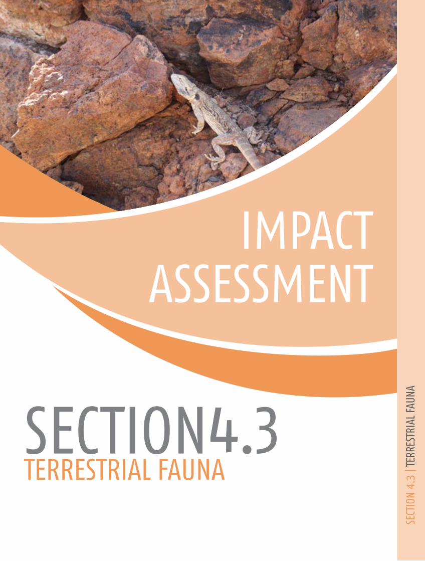
TERRESTRIAL FAUNASECTION4.3

4.3-i Jervois Base Metal Project
This page is intentionally left blank

4.3-1 Jervois Base Metal Project
Jervois Base Metal Project VOLUME 2 Impact Assessment
SECTION 4.3| TERRESTRIAL FAUNA
4.3 Terrestrial Fauna
4.3.1. Introduction The Jervois Base Metal Project Environmental Impact Statement (EIS) Terms of Reference has
identified terrestrial fauna as a preliminary environmental factor that may be impacted by the Project.
As such, the EIS is to provide sufficient information regarding the existing environment, the potential
impacts and risks arising from the Project and the proposed management and mitigation measures to
be implemented to meet the Northern Territory Environment Protection Authority (NT EPA) objectives.
The NT EPA’s objective related to terrestrial fauna is to:
“maintain the conservation status, diversity, ecological integrity and geographic distribution
of terrestrial fauna values through the avoidance or management of adverse impacts”.
The NT EPA has Guidelines for Assessment of Impacts on Terrestrial Biodiversity (NT EPA, 2013) that
provide guidance as to the level of detail required for terrestrial fauna within the EIS document. As
recommended by the guideline, this Section of the EIS has aimed to include detail on the following:
• the threatened fauna (as listed under the TPWCA and/or EPBC Act) of proposed development
sites and immediately adjacent areas
• congregations, large populations or important sites for listed migratory fauna (EPBC Act)
found on the proposed development site
• important fauna sites (e.g. major breeding areas, fauna congregations, isolated permanent
water sources, geological features such as caves, large boulder piles or escarpments) in the
proposed development area
• the local and regional conservation status of threatened fauna, listed migratory fauna, or
important fauna congregations or sites present in development sites
• the potential impacts of projects on threatened fauna, listed migratory fauna, or important
fauna congregations or sites in, adjacent to, and downstream from development sites; and
• the conservation significance of a development’s impacts on threatened fauna, listed
migratory fauna, important fauna congregations or sites at local and regional levels.
In order to satisfy the above listed requirements of the terrestrial fauna assessment, a number of
ecological investigations were undertaken by Low Ecological Services P/L between 1985 and 2018.
The reports from these ecological investigations appear in Appendix C-7.
Relevant legislation
There are a number of pieces of legislation written by the Commonwealth and Northern Territory
governments that may be relevant to the terrestrial fauna potentially impacted by the Project,
including:
Impact Assessment
SECTION 4.3| Terrestrial Fauna 4.3-2
• Environment Protection and Biodiversity Conservation Act, 1999 (Commonwealth)
• Environmental Assessment Act 1994 (Northern Territory)
• Environmental Protection Act 2012 (Northern Territory)
• Biological Control Act 2011 (Northern Territory)
• Territory Parks and Wildlife Conservation Act 2014 (Northern Territory); and
• Weeds Management Act 2001 (Northern Territory).
Where relevant, the EIS has addressed the requirements of the legislation within the document. It is
noted that the Project was referred to the Commonwealth Department of Environment and Energy
(DEE) in November 2013 and was deemed a non-controlled action.
4.3.2. Relevant activities The Project is described as the re-opening of a mine. The Project area has been the subject of historic
exploration and mining by various operators since 1929. Existing infrastructure at the site includes
open pits, access roads, ruins from an old village and several mines and processing sites, waste rock
dumps, tails storage facilities, evaporation dams, and drains and sumps. The Project involves mining
copper and other base metals from at least five deposits. Ore will be processed onsite using a crushing,
grinding and flotation plant, producing copper and lead/zinc concentrate.
The proposed Project infrastructure includes a processing plant, workshops, laydown areas, an
explosive magazine, offices, warehouses, a laboratory, haul roads, sewage treatment systems, 12 MW
diesel and/or gas fired power station, powerlines, water storages and an accommodation camp. The
workforce is estimated to peak at approximately 300 staff during full production of underground and
open cut operations, and will operate on a drive-in drive-out and fly-in fly-out basis. The Project was
deemed “not a controlled action” under the EPBC Act.
The proposed activities that may have a significant impact on and/or pose a direct or indirect risk to
terrestrial fauna, are described as follows:
• Construction of associated infrastructure (i.e. topsoil stockpiles, workshops, laydown areas,
explosives magazine, offices, warehouse, laboratory, haul roads, sewage treatment systems,
pipelines, power station (diesel or gas), powerlines, water storages and accommodation camp
• Construction of open pits to access ore
• Construction of underground mines to access ore
• Stockpiling of ore
• Stockpiling of waste on purpose built waste landforms adjacent to open pits
• Transport of ore to ROM processing pad (traffic movements)
• Concentration of ore using standard flotation processes to produce concentrate containing
copper sulphide and subordinate silver and other metals
• Discharge of thickened tailings to a purpose built above ground tailings storage facility (TSF)
near the processing plant; and
• Transport of concentrate in enclosed truck containers off-site via the Plenty and Stuart
highways to Alice Springs where it will be loaded onto trains for transport to Darwin and/or
Adelaide.
Potential impacts and risks associated with these activities include:
• Removal of habitat for pits and infrastructure
• Change in habitat quality
Environmental Impact Statement
4.3-3 Jervois Base Metal Project
• Impacts to threatened fauna
• Impacts to migratory fauna
• Introduction of exotic fauna
• Fauna mortality; and
• Hazardous material.
These impacts and risks are discussed in detail in Section 4.3.5.
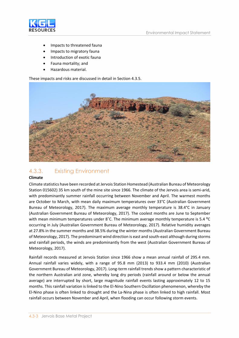
4.3.3. Existing Environment Climate
Climate statistics have been recorded at Jervois Station Homestead (Australian Bureau of Meteorology
Station 015602) 35 km south of the mine site since 1966. The climate of the Jervois area is semi-arid,
with predominantly summer rainfall occurring between November and April. The warmest months
are October to March, with mean daily maximum temperatures over 33°C (Australian Government
Bureau of Meteorology, 2017). The maximum average monthly temperature is 38.4°C in January
(Australian Government Bureau of Meteorology, 2017). The coolest months are June to September
with mean minimum temperatures under 8˚C. The minimum average monthly temperature is 5.4 ⁰C
occurring in July (Australian Government Bureau of Meteorology, 2017). Relative humidity averages
at 27.8% in the summer months and 38.5% during the winter months (Australian Government Bureau
of Meteorology, 2017). The predominant wind direction is east and south-east although during storms
and rainfall periods, the winds are predominantly from the west (Australian Government Bureau of
Meteorology, 2017).
Rainfall records measured at Jervois Station since 1966 show a mean annual rainfall of 295.4 mm.
Annual rainfall varies widely, with a range of 95.8 mm (2013) to 933.4 mm (2010) (Australian
Government Bureau of Meteorology, 2017). Long-term rainfall trends show a pattern characteristic of
the northern Australian arid zone, whereby long dry periods (rainfall around or below the annual
average) are interrupted by short, large magnitude rainfall events lasting approximately 12 to 15
months. This rainfall variation is linked to the El-Nino Southern Oscillation phenomenon, whereby the
El-Nino phase is often linked to drought and the La-Nina phase is often linked to high rainfall. Most
rainfall occurs between November and April, when flooding can occur following storm events.
Impact Assessment
SECTION 4.3| Terrestrial Fauna 4.3-4
Biogeographic region
The Interim Biogeographic Regionalisation of Australia (IBRA Version 7) provides a broad division of
Australia into 89 geographically distinct bioregions based on common climate, geology, landform,
native vegetation and species information (DSEWPC, 2012). The Project area lies at the south edge of
the Channel Country bioregion (Thackway, 1995). Further refinement of these regions into 419 sub-
regions does not affect The Channel Country bioregion which is located on the Queensland (QLD),
New South Wales (NSW), South Australia (SA) and NT borders, with 8% of the bioregion in the NT
(Bastin, 2008). The Channel Country bioregion is characterised by braided, flood and alluvial plains,
which are surrounded by gravel or gibber plains, dunefields and low ranges (Bastin, 2008). The
predominant vegetation is Mitchell grass, gidgee and spinifex (Bastin, 2008). The predominant land
use in the Channel Country bioregion is grazing (91% of total area (Bastin, 2008)). There are no
reserves or protected areas in the Channel Country bioregion (Baker, 2005).
Geology
The Project is within the Huckitta 1:250,000 map sheet (Black, 1984). The north western part of the
Project area is made up of sedimentary sandstone, limestone and dolostone of the Jervois Range
(P103), while the majority of the area overlies felsic and mafic intrusive such as schist and granites
(A5) with limestone and doloritic remnants and intrusives. Soils are variable across the Project area
but are classified as rudosols, young soils with negligible pedologic development. At a local level, soils
vary from deep clayey loam to extensive calcareous loams and shallow skeletal montain earthy sands.
The Australian Soil Classification (ASC) (Isbell, 2016) describes rudosols as follows:
Soil with negligible (rudimentary) pedologic organisation apart from:
i. Minimal development of an Al horizon; or
ii. The presence of less than 10% of B horizon material (including pedogenic carbonate)
in fissures in the parent rock or saprolite. The soils are apedal or only weakly structured
in the A1 horizon and show no pedological colour changes apart from the darkening
of an A1 horizon. There is little or no texture or colour change with depth unless
stratified or buried soils are present.
Hydrology
The Jervois Project area is in the upper catchment of the Hay River Basin, which ultimately feeds into
Lake Eyre in the north of South Australia. The drainage lines that intersect the Project area feed into
the Marshall River to the south and Arthur Creek to the north, which in turn converge into the Hay
River, approximately 60 km south-east of the Project area. Surface water in the Project area and
surrounding region is ephemeral and the creeks hold water during and after rainfall events. Drainage
lines originating in the Jervois Range, include Unca Creek. Unca Creek and its tributaries drain to the
east through the Project area and north-east towards Arthur Creek, but flood out through the broad
drainage plain to the south-east. Other watercourses in the surrounding area include: Daylight Creek
4 km south-west, Midnight Creek 7 km south and Bonya Creek 11 km south-west.
Jervois Dam is an artificial water reservoir at the north-west corner of the Project area, which holds a
substantial volume of water for several years following rainfall. It was constructed for previous mining
operations and is the largest and most permanent surface water body in the Jervois Region. Faulty
construction resulted in a pervious layer in the dam wall which allows seepage which provides long
Environmental Impact Statement
4.3-5 Jervois Base Metal Project
term irrigation for the area immediately east of the dam. It is planned to repair this leak to enable a
larger quantity of water to be available for the mining process.
Groundwater availability on Jervois Station has always been a problem (Low Ecological Services P/L,
1985). Water from Palaeozoic sediments is frequently salty (Black, 1984) but fault and fracture lines
in metamorphic and igneous rock may provide fresh water. Deep Quaternary beds through which
major water courses flow can yield good supplies of fresh water. Unca Bore on the project area is high
in salt content at 3380 TDS.
Fire history
Information on the fire history of the region is provided by the North Australia Fire Information (NAFI)
website (North Australia and Rangelands Fire Information, 2017). Fire histories have been mapped to
the nearest 1 km for years 1997 – 2010 and to the nearest 250 m for years 2004 onwards. Since 1997,
the Project area has only been burnt once, in 2002 following the very wet years from 1999 to 2001.
Widespread fires that burnt much of Central Australia in 2011 and the beginning of 2012 did not affect
the Project area. However, a small isolated fire occurred by the Jervois Dam in 2011. The northern half
of the project area has not experienced any fires since 1997.
4.3.4. Terrestrial Fauna Characteristics of the Project Area A number of ecological investigations were undertaken by Low Ecological Services P/L between 1985
and 2017. The studies included desktop assessment (i.e. interrogation of spatial databases and
reviews of relevant literature) and field work involving on-ground fauna surveys in 1999, 2012, 2013,
2017 and 2018.
Desktop assessment
The database review and GIS mapping of several data sources provided an ecological context of the
landscape, vegetation, habitats and climate of the lease areas. The sources include:
• Climate data online (Australian Government Bureau of Meteorology, 2017)
• Interim Biogeographic Regionalisation of Australia (IBRA) (Thackway, 1995)
• Digital Atlas of Australian Soils (Northcote, 1968)
• Vegetation Survey of the Northern Territory Australia: Notes to accompany 1: 1,000, 000 Map
Sheets (Wilson, 1990)
• Land Systems of the Alice Springs Area, Northern Territory, Australia (Perry, 1962)
• Fire history (North Australia and Rangelands Fire Information, 2017)
• Aerial photographs and satellite imagery
• EPBC Protected Matters Search Tool (PMST) (Department of Environment & Energy (DEE),
2017)
• NT Species Atlas (Department of Environment and Natural Resources (DENR), 2017)
• Jervois Base Metal Project Surface Water Impact Assessment (WRM Water & Environment P/L,
2018); and
• Jervois Base Metal Project Groundwater Impact Assessment (CloudGMS, 2018).
Fauna surveys
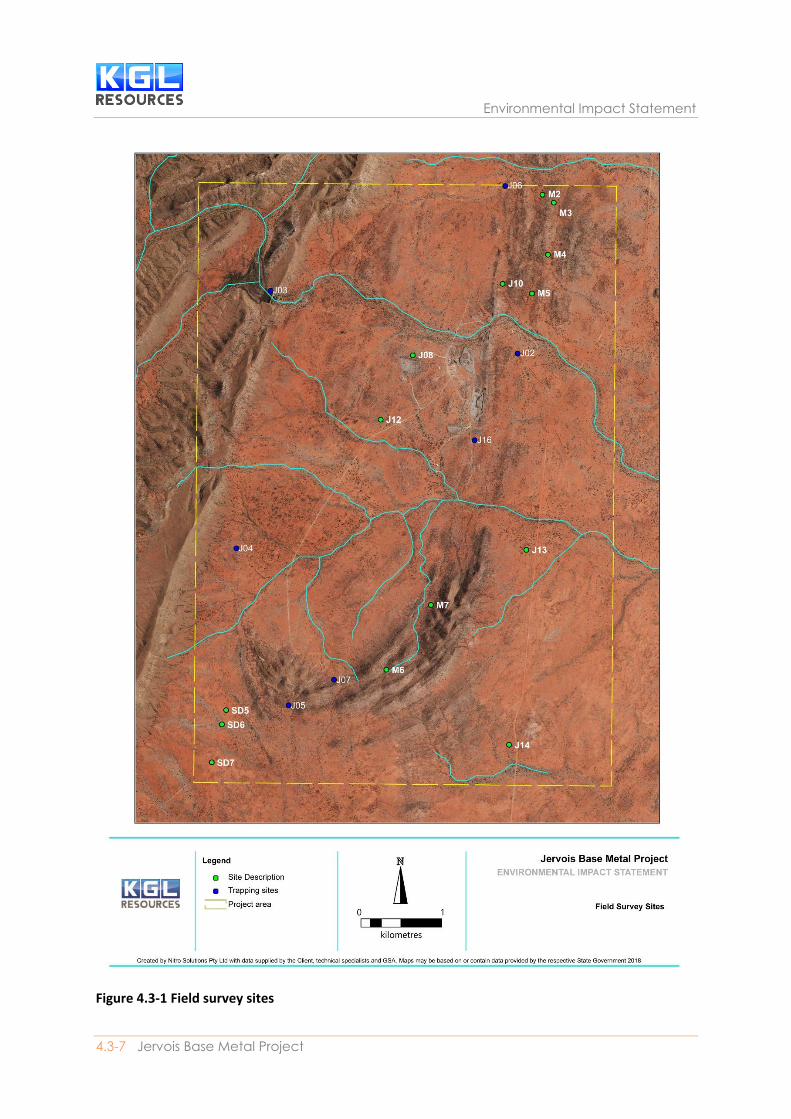
Field surveys were conducted by LES in the late dry (1999 and 2017) and in the post wet (2012, 2013
and 2018), including a total of 25 sites encompassing all land units in the Project area. General fauna
Impact Assessment
SECTION 4.3| Terrestrial Fauna 4.3-6
survey methodology follows the NT EPA “Guidelines for Assessment of Impacts on Terrestrial
Biodiversity” (NT EPA, 2013). Fauna surveys for small mammals and reptiles were conducted at five to
six trapping sites each survey (J01 – J07). Each site was trapped for three nights. At each site there was
a transect of 25 Elliott traps spaced approximately 10 m apart, two pitfall traps and four funnel traps.
Pitfall traps were placed adjacent to Elliott trap transects and had a 10 m drift fence centered over
each pit to guide animals into the trap. One funnel trap was placed at either end of each 10 m drift
fence. Pitfall traps were not used at all sites due to the difficulty of digging in the rocky substrate.
Where this occurred, funnel traps were deployed, sometimes along a 10 m drift fence.
Elliott traps were baited with a mixture of peanut butter and oats. Traps were checked each morning
and animals processed (i.e. noting sex, reproductive status, body length, tail length, snout-vent length
etc.) and released at the point of capture. Elliott traps were closed during the day and then opened in
late afternoon when pitfall and funnel traps were also checked. Cage trapping as recommended by
the Standard terrestrial vertebrate survey methods used by the DLRM (NT EPA, 2013) was not
conducted, as there are no species likely to be present in the appropriate size range for cage trapping.
Medium to large sized mammal (e.g. cats, foxes, dingoes and rabbit) presence and abundance was
determined though remote cameras, spotlighting and secondary sign searches. Trapping sites
established in 2012 were continued in 2013 and 2017, with the addition of one other site in 2012,
another in 2017 and one more in 2018.
Additional targeted searches were conducted for EPBC listed threatened species that may occur within
Project area as identified by the PMST and NT Flora and Fauna Atlas, comprising:
• Australian painted snipe (Rostratula australis) – Endangered (EPBC Act) and Vulnerable (TPWC
Act)
• Curlew sandpiper (Calidris ferruginea) – Critically Endangered (EPBC Act) and Vulnerable
(TPWC Act)
• Night parrot (Pezoporus accidentalis) - Endangered (EPBC Act) and Critically Endangered
(TPWC Act)
• Plains wanderer (Pedionomus torquatus) – Critically Endangered (EPBC Act) and Data Deficient
(TPWC Act)
• Red goshawk (Erythrotriorchis radiatus) – Vulnerable (EPBC Act and TPWC Act)
• Black-footed rock wallaby (Petrogale lateralis) - Vulnerable (EPBC Act) and Near Threatened
(TPWC Act); and
• Common brushtail possum (Central Australian population) (Trichosurus vulpecula) –
Endangered (TPWC Act).
Survey methods used to determine the presence of threatened species were based on the Survey
Guidelines for Australia’s Threatened Mammals (Department of Sustainability, Environment, Water,
Population and Communities (DSEWPC), 2011) and Survey Guidelines for Australia’s Threatened Birds
(Department of the Environment, Water, Heritage and the Arts (DEWHA), 2010).
Environmental Impact Statement
4.3-7 Jervois Base Metal Project
Figure 4.3-1 Field survey sites

Impact Assessment
SECTION 4.3| Terrestrial Fauna 4.3-8
4.3.4.1. Habitat types The Project area, which is estimated at 3,800 ha, contains areas of remnant vegetation as well as some
areas of historic disturbance (i.e. for previous mining activities). Based on survey results, eight refined
vegetation communities have been mapped over the entire Project area (refer to Section 4.1
Terrestrial Flora and Vegetation). Fauna distribution and abundance is influenced by species specific
responses to broad habitat types, rather than to refined vegetation communities. For the purposes of
this report, the eight refined vegetation communities have been grouped into six broad habitat types
based on geology, vegetation structure and complexity, and characteristic species, which translate
into differences in the nature and availability of resources relevant to fauna. The six broad habitat
types have been extracted from Figure 4.3-2 and are outlined in Table 4.3-1.
Table 4.3-1 Broad Habitat Types in the Project area
Broad Habitat Type Vegetation Community
Refined Vegetation Communities Amount in Project area
(ha)
Hummock grassland 1 Hummock (Triodia basedowii, Triodia pungens) grassland with sparse shrubs and low trees (VC1).
345.7
Low Acacia sp. shrubland
2, 6, 8 Sparse, low Acacia siberica shrubland over short grasses and forbs (VC2).
Sparse low Acacia woodland over hummock grasses (VC6).
Acacia georginae (Gidgee) dominated woodland. Sparse grass and forb understorey (VC8).
1,322.6
Tall Acacia sp. woodland
3, 4 Acacia estrophiolata tall, open woodland over short grasses with sparse shrubs (VC3).
Tall Acacia aneura woodland over short grasses in fire protected valleys and upper reaches of drainage lines (VC4).
151.3
Tall Corymbia sp. and Acacia sp. woodland
5 Tall, open woodland with Corymbia and Acacia siberica over short grasses and forbs; on floodplains and at the base of ranges (VC5).
1,843
Tall Eucalyptus sp. woodland on drainage lines
7 Eucalyptus camaldulensis tall woodland over sparse grasses in drainage channels and rocky creek beds (VC7).
116.5
Jervois Dam 7 Large artificial lake on Unca Creek, created by the presence of a dam.
6.7

Environmental Impact Statement
4.3-9 Jervois Base Metal Project
Figure 4.3-2 Refined Vegetation Communities Source: Low Ecological Services, 2018
Impact Assessment
SECTION 4.3| Terrestrial Fauna 4.3-10
4.3.4.2. Important Congregations of or Sites for Fauna Important congregations of fauna or sites for fauna include locations with:
• Seasonal feeding/roosting congregations of migrant species
• Colonies of roosting species
• Breeding colonies
• Caves
• Breeding areas for species with known highly specific breeding area requirements e.g.
Gouldian finches; and
• Isolated and possibly spatially rare habitat resources important to fauna or of importance to
fauna at a particular time of year or the life cycle e.g. isolated sources of permanent water,
large boulder piles, escarpments.
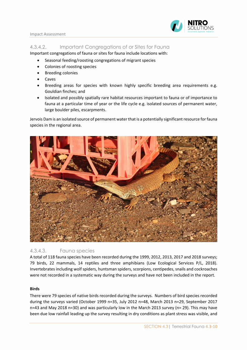
Jervois Dam is an isolated source of permanent water that is a potentially significant resource for fauna
species in the regional area.
4.3.4.3. Fauna species A total of 118 fauna species have been recorded during the 1999, 2012, 2013, 2017 and 2018 surveys;
79 birds, 22 mammals, 14 reptiles and three amphibians (Low Ecological Services P/L, 2018).
Invertebrates including wolf spiders, huntsman spiders, scorpions, centipedes, snails and cockroaches
were not recorded in a systematic way during the surveys and have not been included in the report.
Birds
There were 79 species of native birds recorded during the surveys. Numbers of bird species recorded
during the surveys varied (October 1999 n=35, July 2012 n=48, March 2013 n=29, September 2017
n=43 and May 2018 n=30) and was particularly low in the March 2013 survey (n= 29). This may have
been due low rainfall leading up the survey resulting in dry conditions as plant stress was visible, and
Environmental Impact Statement
4.3-11 Jervois Base Metal Project
hot conditions during the survey. There was one species of conservation significance recorded in the
Project area, emu (Dromaius novaehollandiae) which is listed as Near Threatened under the TPWC Act.
Mammals
There were 22 species of mammals recorded during the surveys, including four exotic species (i.e. cow,
cat, house mouse and rabbit). This also includes six species of bat recorded with bat detectors. The
number of mammals caught was relatively consistent throughout the surveys (October 1999 n=7, July
2012 n=8, March 2013 n=6, September 2017 n=8 and May 2018 n=2). There was one species of
conservation significance recorded in the Project area, long-haired rat (Rattus villosissimus) which is
listed as Near Threatened under the TPWC Act.
Reptiles
Fourteen species of reptile were recorded from the Project area during surveys, including three
species of snake. Fewer reptiles were recorded during surveys in cooler months (October 1999 n=6,
July 2012 n=4, March 2013 n= 5, September 2017 n=3 and May 2018 n=1). There were no exotic or
conservation significant reptiles detected.
Amphibians
Three amphibian species were recorded from the Project area during surveys; including two near the
Jervois Dam during the October 1999 (Limnodynastes spenceri (Spencer’s burrowing frog) and Litoria
rubella (desert tree frog)) and another one Cyclorana cultripes (burrowing frog) in May 2018. There
was good rain leading up to the October 1999 survey and the frogs were active due to rain overnight
during the survey. Litoria rubella was observed at the camp during the September 2017 field survey.
There were no exotic or conservation significant amphibians detected.
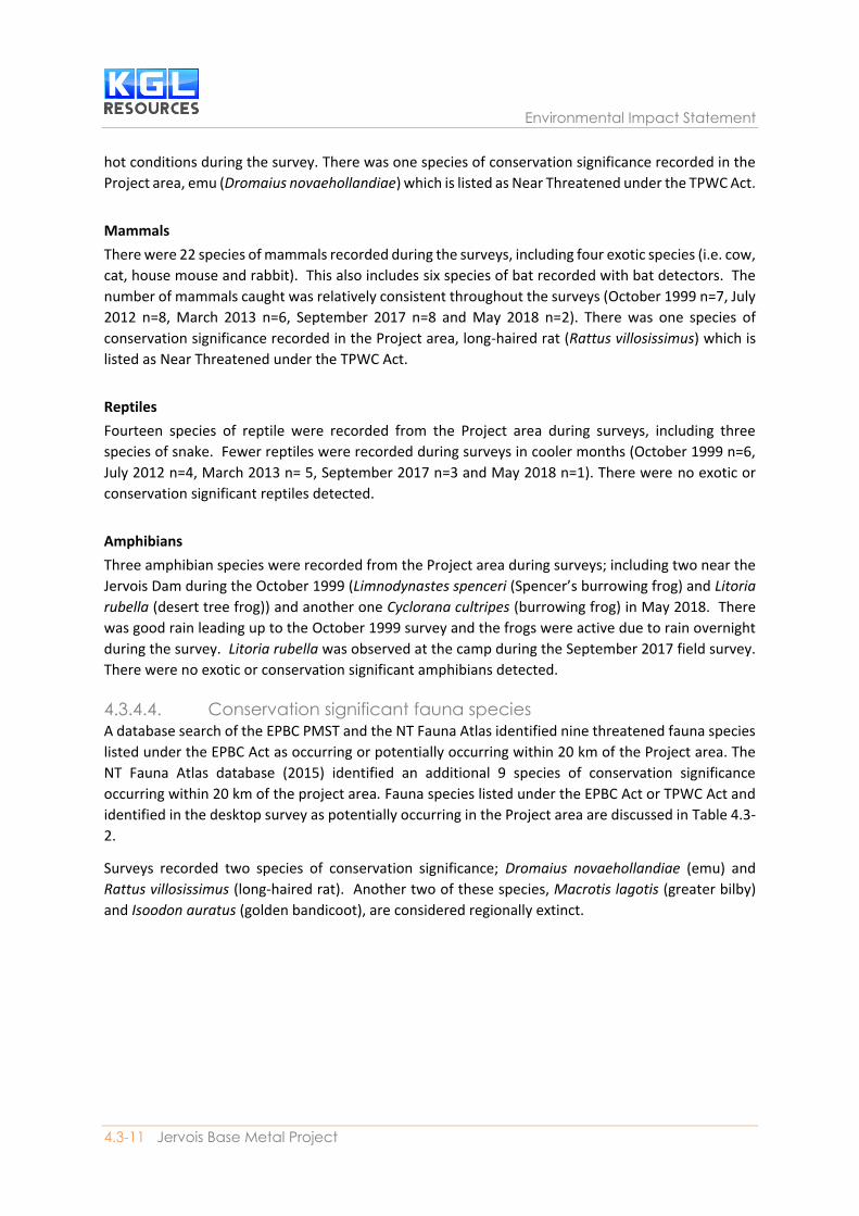
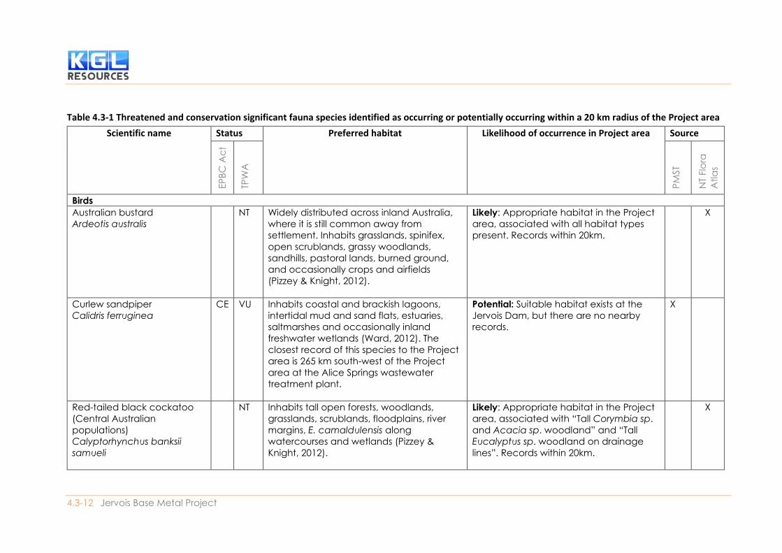
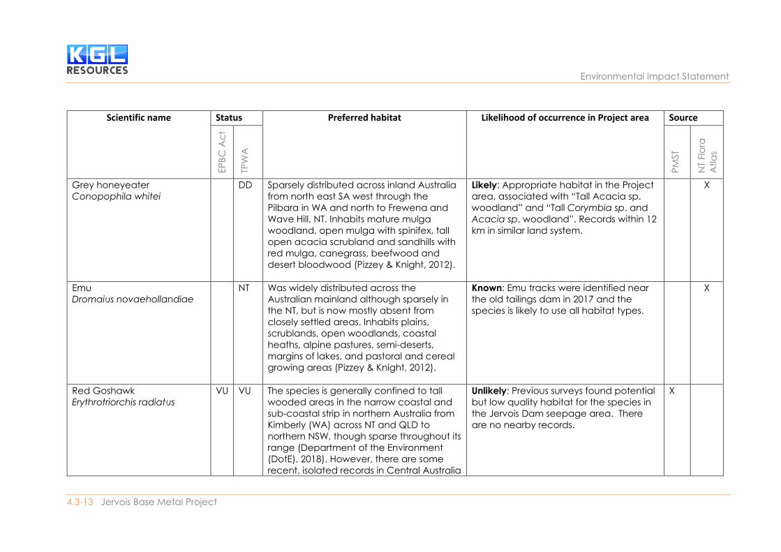
4.3.4.4. Conservation significant fauna species A database search of the EPBC PMST and the NT Fauna Atlas identified nine threatened fauna species
listed under the EPBC Act as occurring or potentially occurring within 20 km of the Project area. The
NT Fauna Atlas database (2015) identified an additional 9 species of conservation significance
occurring within 20 km of the project area. Fauna species listed under the EPBC Act or TPWC Act and
identified in the desktop survey as potentially occurring in the Project area are discussed in Table 4.3-
2.
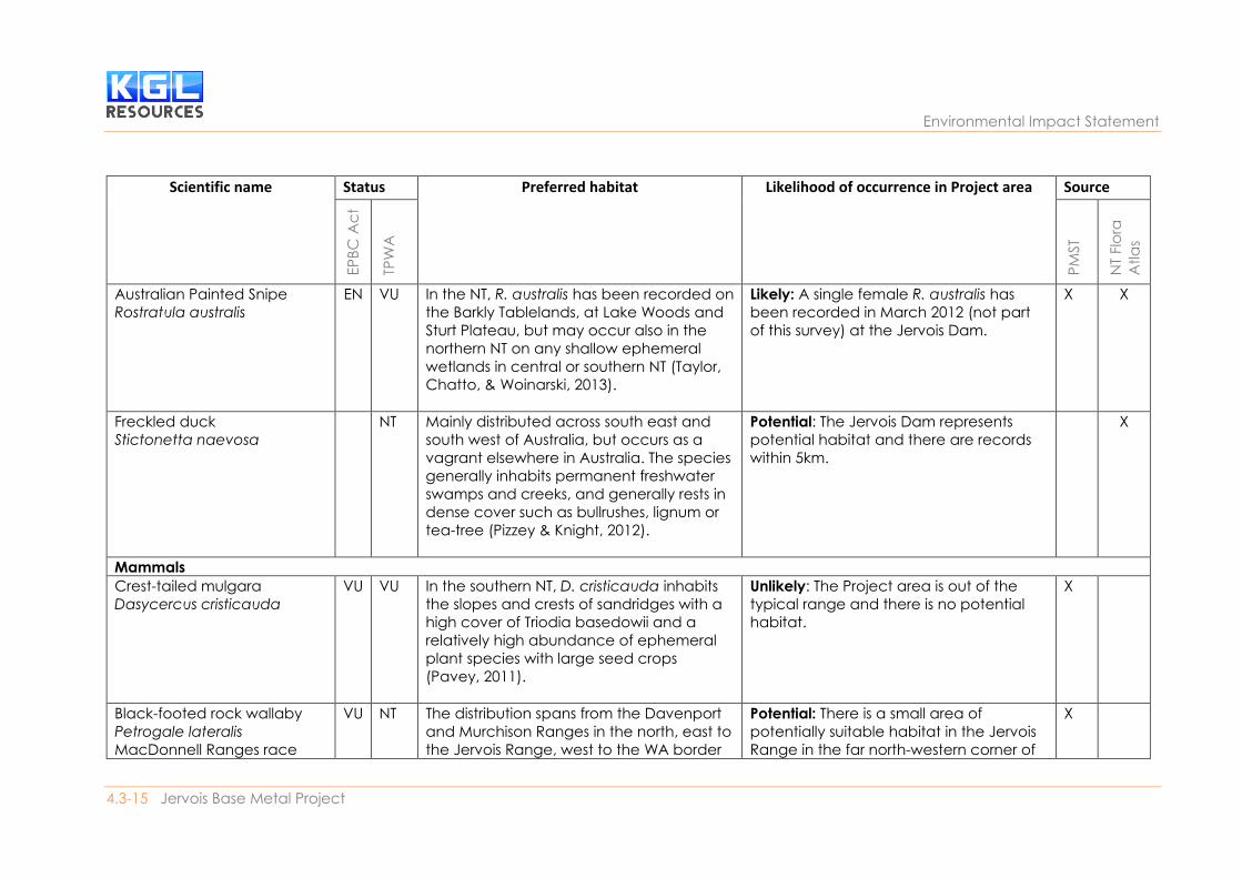
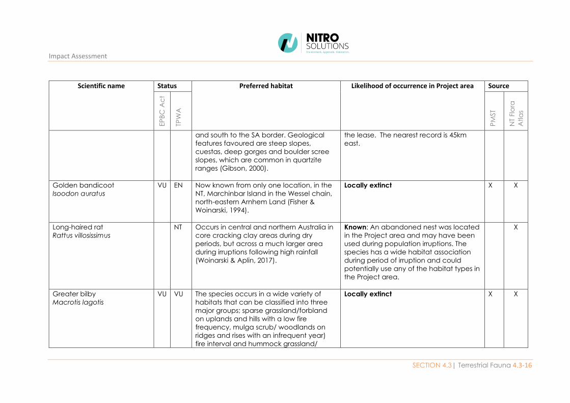
Surveys recorded two species of conservation significance; Dromaius novaehollandiae (emu) and
Rattus villosissimus (long-haired rat). Another two of these species, Macrotis lagotis (greater bilby)
and Isoodon auratus (golden bandicoot), are considered regionally extinct.
4.3-12 Jervois Base Metal Project
Table 4.3-1 Threatened and conservation significant fauna species identified as occurring or potentially occurring within a 20 km radius of the Project area
Scientific name Status Preferred habitat Likelihood of occurrence in Project area Source
EP
BC
Ac
t
TPW
A
PM
ST
NT
Flo
ra
Atla
s
Birds
Australian bustard
Ardeotis australis
NT Widely distributed across inland Australia,
where it is still common away from
settlement. Inhabits grasslands, spinifex,
open scrublands, grassy woodlands,
sandhills, pastoral lands, burned ground,
and occasionally crops and airfields
(Pizzey & Knight, 2012).
Likely: Appropriate habitat in the Project
area, associated with all habitat types
present. Records within 20km.
X
Curlew sandpiper
Calidris ferruginea
CE VU Inhabits coastal and brackish lagoons,
intertidal mud and sand flats, estuaries,
saltmarshes and occasionally inland
freshwater wetlands (Ward, 2012). The
closest record of this species to the Project
area is 265 km south-west of the Project
area at the Alice Springs wastewater
treatment plant.
Potential: Suitable habitat exists at the
Jervois Dam, but there are no nearby
records.
X
Red-tailed black cockatoo
(Central Australian
populations)
Calyptorhynchus banksii
samueli
NT Inhabits tall open forests, woodlands,
grasslands, scrublands, floodplains, river
margins, E. camaldulensis along
watercourses and wetlands (Pizzey &
Knight, 2012).
Likely: Appropriate habitat in the Project
area, associated with “Tall Corymbia sp.
and Acacia sp. woodland” and “Tall
Eucalyptus sp. woodland on drainage
lines”. Records within 20km.
X
Environmental Impact Statement
4.3-13 Jervois Base Metal Project
Scientific name Status Preferred habitat Likelihood of occurrence in Project area Source
EP
BC
Ac
t
TPW
A
PM
ST
NT
Flo
ra
Atla
s
Grey honeyeater
Conopophila whitei
DD Sparsely distributed across inland Australia
from north east SA west through the
Pilbara in WA and north to Frewena and
Wave Hill, NT. Inhabits mature mulga
woodland, open mulga with spinifex, tall
open acacia scrubland and sandhills with
red mulga, canegrass, beefwood and
desert bloodwood (Pizzey & Knight, 2012).
Likely: Appropriate habitat in the Project
area, associated with “Tall Acacia sp.
woodland” and “Tall Corymbia sp. and
Acacia sp. woodland”. Records within 12
km in similar land system.
X
Emu
Dromaius novaehollandiae
NT Was widely distributed across the
Australian mainland although sparsely in
the NT, but is now mostly absent from
closely settled areas. Inhabits plains,
scrublands, open woodlands, coastal
heaths, alpine pastures, semi-deserts,
margins of lakes, and pastoral and cereal
growing areas (Pizzey & Knight, 2012).
Known: Emu tracks were identified near
the old tailings dam in 2017 and the
species is likely to use all habitat types.
X
Red Goshawk
Erythrotriorchis radiatus
VU VU The species is generally confined to tall
wooded areas in the narrow coastal and
sub-coastal strip in northern Australia from
Kimberly (WA) across NT and QLD to
northern NSW, though sparse throughout its
range (Department of the Environment
(DotE), 2018). However, there are some
recent, isolated records in Central Australia
Unlikely: Previous surveys found potential
but low quality habitat for the species in
the Jervois Dam seepage area. There
are no nearby records.
X
Impact Assessment
SECTION 4.3| Terrestrial Fauna 4.3-14
Scientific name Status Preferred habitat Likelihood of occurrence in Project area Source
EP
BC
Ac
t
TPW
A
PM
ST
NT
Flo
ra
Atla
s
(Debus, 2012). he preferred habitat is tall
open eucalypt forest and riparian areas
(Woinarski, 2006).
Square-tailed kite
Lophoictinia isura
NT Inhabits heathlands, woodlands, forests,
tropical and subtropical rainforests,
timbered watercourses, and hills and
gorges across much of Australia except
the central and inland south (Pizzey &
Knight, 2012).
Potential: Appropriate habitat in the
Project area, associated with “Tall
Corymbia sp. and Acacia sp. woodland”
and “Tall Eucalyptus sp. woodland on
drainage lines”. The species has been
recorded previously within the Project
area in the Bond Springs land system.
X
Plains wanderer
Pedionomus torquatus
CE DD Known from south-eastern Australia,
particularly in the Riverina, with some
isolated records in SA and inland QLD. The
preferred habitat is sparse low grasslands,
typically with 50% bare ground and most
vegetation under 5 cm in heigh (Woinarski
& Ward, 2016) t.
Unlikely: The Project area is out of the
typical range and there is no potential
habitat.
X
Night parrot
Pezoporus occidentalis
EN CE Restricted to arid and semi-arid Australia.
Records of P. occidentalis in western QLD,
northern WA and southern NT are from
spinifex (Triodia sp.) hummock grasslands in
stony or sandy areas (Pavey, 2006).
Unlikely: The Project area is out of the
typical range and there is no potential
habitat.
X
Environmental Impact Statement
4.3-15 Jervois Base Metal Project
Scientific name Status Preferred habitat Likelihood of occurrence in Project area Source
EP
BC
Ac
t
TPW
A
PM
ST
NT
Flo
ra
Atla
s
Australian Painted Snipe
Rostratula australis
EN VU In the NT, R. australis has been recorded on
the Barkly Tablelands, at Lake Woods and
Sturt Plateau, but may occur also in the
northern NT on any shallow ephemeral
wetlands in central or southern NT (Taylor,
Chatto, & Woinarski, 2013).
Likely: A single female R. australis has
been recorded in March 2012 (not part
of this survey) at the Jervois Dam.
X X
Freckled duck
Stictonetta naevosa
NT Mainly distributed across south east and
south west of Australia, but occurs as a
vagrant elsewhere in Australia. The species
generally inhabits permanent freshwater
swamps and creeks, and generally rests in
dense cover such as bullrushes, lignum or
tea-tree (Pizzey & Knight, 2012).
Potential: The Jervois Dam represents
potential habitat and there are records
within 5km.
X
Mammals
Crest-tailed mulgara
Dasycercus cristicauda
VU VU In the southern NT, D. cristicauda inhabits
the slopes and crests of sandridges with a
high cover of Triodia basedowii and a
relatively high abundance of ephemeral
plant species with large seed crops
(Pavey, 2011).
Unlikely: The Project area is out of the
typical range and there is no potential
habitat.
X
Black-footed rock wallaby
Petrogale lateralis
MacDonnell Ranges race
VU NT The distribution spans from the Davenport
and Murchison Ranges in the north, east to
the Jervois Range, west to the WA border
Potential: There is a small area of
potentially suitable habitat in the Jervois
Range in the far north-western corner of
X
Impact Assessment
SECTION 4.3| Terrestrial Fauna 4.3-16
Scientific name Status Preferred habitat Likelihood of occurrence in Project area Source
EP
BC
Ac
t
TPW
A
PM
ST
NT
Flo
ra
Atla
s
and south to the SA border. Geological
features favoured are steep slopes,
cuestas, deep gorges and boulder scree
slopes, which are common in quartzite
ranges (Gibson, 2000).
the lease. The nearest record is 45km
east.
Golden bandicoot
Isoodon auratus
VU EN Now known from only one location, in the
NT, Marchinbar Island in the Wessel chain,
north-eastern Arnhem Land (Fisher &
Woinarski, 1994).
Locally extinct X X
Long-haired rat
Rattus villosissimus
NT Occurs in central and northern Australia in
core cracking clay areas during dry
periods, but across a much larger area
during irruptions following high rainfall
(Woinarski & Aplin, 2017).
Known: An abandoned nest was located
in the Project area and may have been
used during population irruptions. The
species has a wide habitat association
during period of irruption and could
potentially use any of the habitat types in
the Project area.
X
Greater bilby
Macrotis lagotis
VU VU The species occurs in a wide variety of
habitats that can be classified into three
major groups; sparse grassland/forbland
on uplands and hills with a low fire
frequency, mulga scrub/ woodlands on
ridges and rises with an infrequent year)
fire interval and hummock grassland/
Locally extinct X X

Environmental Impact Statement
4.3-17 Jervois Base Metal Project
Scientific name Status Preferred habitat Likelihood of occurrence in Project area Source
EP
BC
Ac
t
TPW
A
PM
ST
NT
Flo
ra
Atla
s
mixed shrub or woodland steppe on plains
and alluvial areas with a high (4-10 year)
fire frequency (Southgate, 1990).
Common brushtail possum
(Central Australian
population)
Trichosurus vulpecula
vulpecula
EN This species occurs in isolated populations
in southern NT. It is restricted to riverine
habitat, close to rocky outcrops and moist
gullies within ranges or rocky slopes (Pavey
& Ward, 2012).
Unlikely: The Project area is out of the
typical range and there is no potential
habitat.
X
Spectacled hare wallaby
Lagorchestes conspicillatus
NT Patchily distributed in northern WA and
central-northern NT, and widespread in
areas northern Queensland from Cape
York to Rockhampton. Inhabits open
forests, open woodland, tall shrublands,
and tussock and hummock grasslands,
and regularly feeds in areas regenerating
after fire (Winter, Woinarski, & Burbidge,
2016).
Unlikely: The Project area is out of the
typical range and there is no potential
habitat.
X
4.3-18 Jervois Base Metal Project
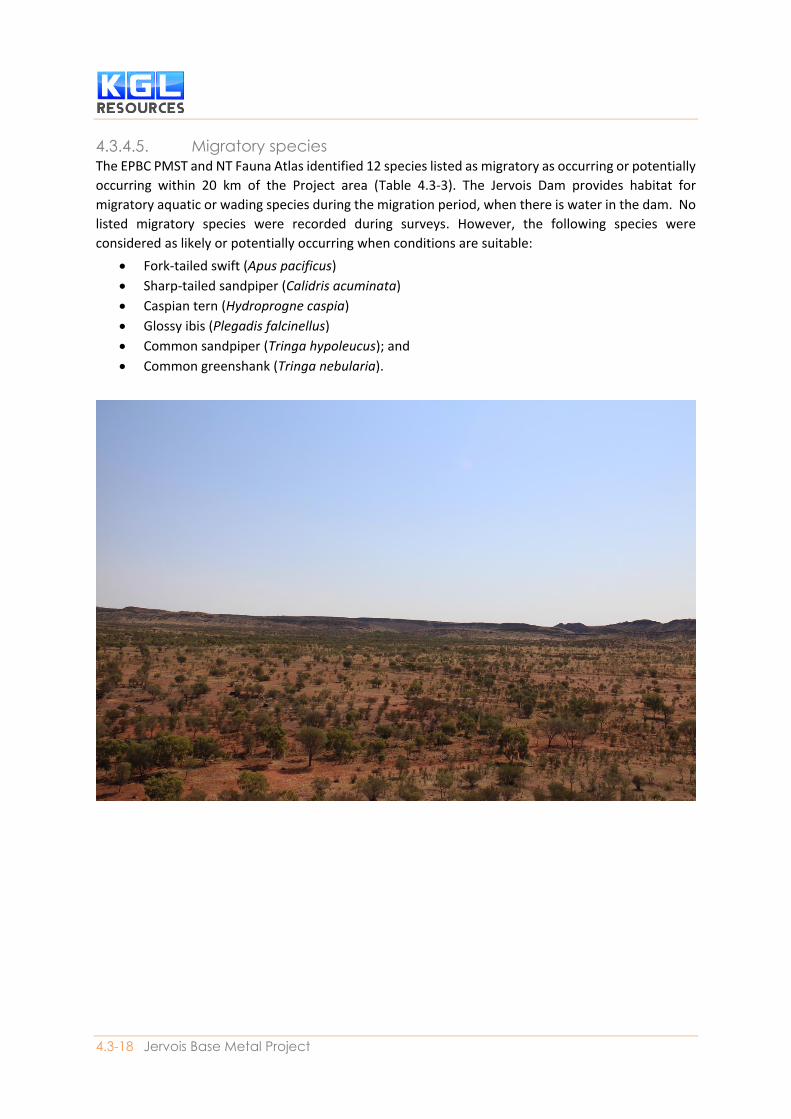
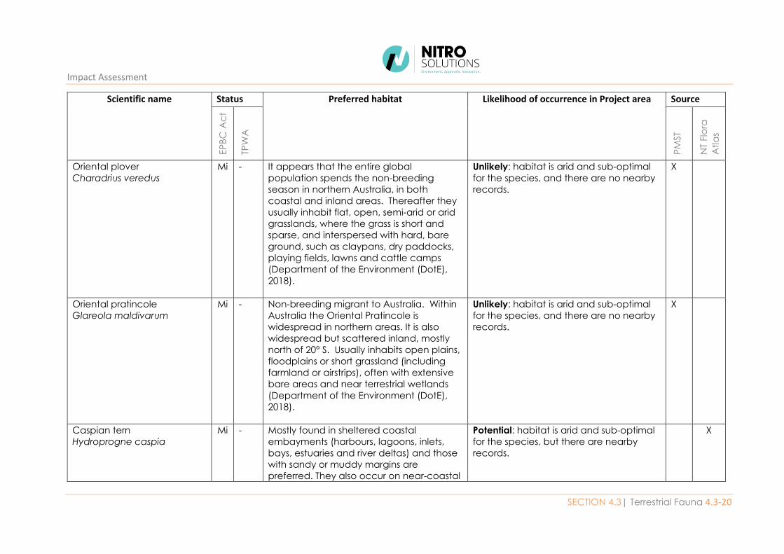
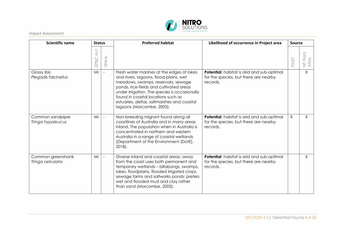
4.3.4.5. Migratory species The EPBC PMST and NT Fauna Atlas identified 12 species listed as migratory as occurring or potentially
occurring within 20 km of the Project area (Table 4.3-3). The Jervois Dam provides habitat for
migratory aquatic or wading species during the migration period, when there is water in the dam. No
listed migratory species were recorded during surveys. However, the following species were
considered as likely or potentially occurring when conditions are suitable:
• Fork-tailed swift (Apus pacificus)
• Sharp-tailed sandpiper (Calidris acuminata)
• Caspian tern (Hydroprogne caspia)
• Glossy ibis (Plegadis falcinellus)
• Common sandpiper (Tringa hypoleucus); and
• Common greenshank (Tringa nebularia).
4.3-19 Jervois Base Metal Project
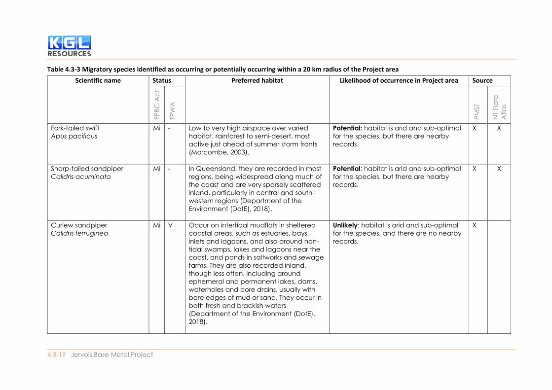
Table 4.3-3 Migratory species identified as occurring or potentially occurring within a 20 km radius of the Project area
Scientific name Status Preferred habitat Likelihood of occurrence in Project area Source
EP
BC
Ac
t
TPW
A
PM
ST
NT
Flo
ra
Atla
s
Fork-tailed swift
Apus pacificus
Mi - Low to very high airspace over varied
habitat, rainforest to semi-desert, most
active just ahead of summer storm fronts
(Morcombe, 2003).
Potential: habitat is arid and sub-optimal
for the species, but there are nearby
records.
X X
Sharp-tailed sandpiper
Calidris acuminata
Mi - In Queensland, they are recorded in most
regions, being widespread along much of
the coast and are very sparsely scattered
inland, particularly in central and south-
western regions (Department of the
Environment (DotE), 2018).
Potential: habitat is arid and sub-optimal
for the species, but there are nearby
records.
X X
Curlew sandpiper
Calidris ferruginea
Mi V Occur on intertidal mudflats in sheltered
coastal areas, such as estuaries, bays,
inlets and lagoons, and also around non-
tidal swamps, lakes and lagoons near the
coast, and ponds in saltworks and sewage
farms. They are also recorded inland,
though less often, including around
ephemeral and permanent lakes, dams,
waterholes and bore drains, usually with
bare edges of mud or sand. They occur in
both fresh and brackish waters
(Department of the Environment (DotE),
2018).
Unlikely: habitat is arid and sub-optimal
for the species, and there are no nearby
records.
X
Impact Assessment
SECTION 4.3| Terrestrial Fauna 4.3-20
Scientific name Status Preferred habitat Likelihood of occurrence in Project area Source
EP
BC
Ac
t
TPW
A
PM
ST
NT
Flo
ra
Atla
s
Oriental plover
Charadrius veredus
Mi - It appears that the entire global
population spends the non-breeding
season in northern Australia, in both
coastal and inland areas. Thereafter they
usually inhabit flat, open, semi-arid or arid
grasslands, where the grass is short and
sparse, and interspersed with hard, bare
ground, such as claypans, dry paddocks,
playing fields, lawns and cattle camps
(Department of the Environment (DotE),
2018).
Unlikely: habitat is arid and sub-optimal
for the species, and there are no nearby
records.
X
Oriental pratincole
Glareola maldivarum
Mi - Non-breeding migrant to Australia. Within
Australia the Oriental Pratincole is
widespread in northern areas. It is also
widespread but scattered inland, mostly
north of 20° S. Usually inhabits open plains,
floodplains or short grassland (including
farmland or airstrips), often with extensive
bare areas and near terrestrial wetlands
(Department of the Environment (DotE),
2018).
Unlikely: habitat is arid and sub-optimal
for the species, and there are no nearby
records.
X
Caspian tern
Hydroprogne caspia
Mi - Mostly found in sheltered coastal
embayments (harbours, lagoons, inlets,
bays, estuaries and river deltas) and those
with sandy or muddy margins are
preferred. They also occur on near-coastal
Potential: habitat is arid and sub-optimal
for the species, but there are nearby
records.
X

Environmental Impact Statement
4.3-21 Jervois Base Metal Project
Scientific name Status Preferred habitat Likelihood of occurrence in Project area Source
EP
BC
Ac
t
TPW
A
PM
ST
NT
Flo
ra
Atla
s
or inland terrestrial wetlands that are either
fresh or saline, especially lakes (including
ephemeral lakes), waterholes, reservoirs,
rivers and creeks. They also use artificial
wetlands, including reservoirs, sewage
ponds and saltworks (Department of the
Environment (DotE), 2018).
Barn swallow
Hirundo rustica
Mi - In Australia, the Barn Swallow is recorded in
open country in coastal lowlands, often
near water, towns and cities. Birds are
often sighted perched on overhead wires,
and also in or over freshwater wetlands,
paperbark Melaleuca woodland,
mesophyll shrub thickets and tussock
grassland (Department of the Environment
(DotE), 2018).
Unlikely: habitat is arid and not suitable
for the species, and there are no nearby
records.
X
Grey wagtail
Motacilla cinerea
Mi - Non-breeding summer visitor to northern
Australia. Prefers running water in disused
quarries, sandy or rocky escarpments,
rainforests, sewage ponds, ploughed fields
and airfields (Morcombe, 2003).
Unlikely: habitat is arid and not suitable
for the species, and there are no nearby
records.
X
Yellow wagtail
Motacilla flava
MI - Open habitats, often near water; it is
usually coastal (Morcombe, 2003).
Unlikely: habitat is arid and not suitable
for the species, and there are no nearby
records.
X
Impact Assessment
SECTION 4.3| Terrestrial Fauna 4.3-22
Scientific name Status Preferred habitat Likelihood of occurrence in Project area Source
EP
BC
Ac
t
TPW
A
PM
ST
NT
Flo
ra
Atla
s
Glossy ibis
Plegadis falcinellus
Mi - Fresh water marshes at the edges of lakes
and rivers, lagoons, flood-plains, wet
meadows, swamps, reservoirs, sewage
ponds, rice-fields and cultivated areas
under irrigation. The species is occasionally
found in coastal locations such as
estuaries, deltas, saltmarshes and coastal
lagoons (Morcombe, 2003).
Potential: habitat is arid and sub-optimal
for the species, but there are nearby
records.
X
Common sandpiper
Tringa hypoleucus
Mi - Non-breeding migrant found along all
coastlines of Australia and in many areas
inland. The population when in Australia is
concentrated in northern and western
Australia in a range of coastal wetlands
(Department of the Environment (DotE),
2018).
Potential: habitat is arid and sub-optimal
for the species, but there are nearby
records.
X X
Common greenshank
Tringa nebularia
Mi - Diverse inland and coastal areas; away
from the coast uses both permanent and
temporary wetlands – billabongs, swamps,
lakes, floodplains, flooded irrigated crops,
sewage farms and saltworks ponds; prefers
wet and flooded mud and clay rather
than sand (Morcombe, 2003).
Potential: habitat is arid and sub-optimal
for the species, but there are nearby
records.
X
4.3-23 Jervois Base Metal Project
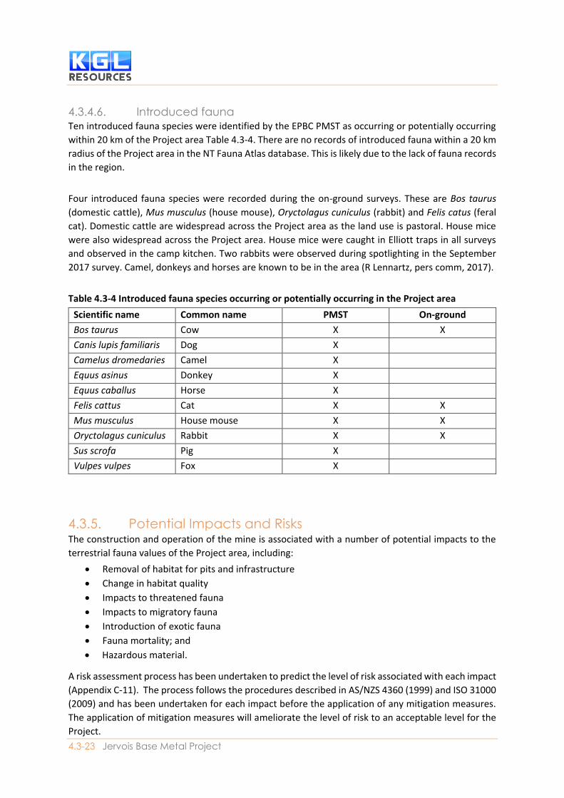
4.3.4.6. Introduced fauna Ten introduced fauna species were identified by the EPBC PMST as occurring or potentially occurring
within 20 km of the Project area Table 4.3-4. There are no records of introduced fauna within a 20 km
radius of the Project area in the NT Fauna Atlas database. This is likely due to the lack of fauna records
in the region.
Four introduced fauna species were recorded during the on-ground surveys. These are Bos taurus
(domestic cattle), Mus musculus (house mouse), Oryctolagus cuniculus (rabbit) and Felis catus (feral
cat). Domestic cattle are widespread across the Project area as the land use is pastoral. House mice
were also widespread across the Project area. House mice were caught in Elliott traps in all surveys
and observed in the camp kitchen. Two rabbits were observed during spotlighting in the September
2017 survey. Camel, donkeys and horses are known to be in the area (R Lennartz, pers comm, 2017).
Table 4.3-4 Introduced fauna species occurring or potentially occurring in the Project area
Scientific name Common name PMST On-ground
Bos taurus Cow X X
Canis lupis familiaris Dog X
Camelus dromedaries Camel X
Equus asinus Donkey X
Equus caballus Horse X
Felis cattus Cat X X
Mus musculus House mouse X X
Oryctolagus cuniculus Rabbit X X
Sus scrofa Pig X
Vulpes vulpes Fox X
4.3.5. Potential Impacts and Risks The construction and operation of the mine is associated with a number of potential impacts to the
terrestrial fauna values of the Project area, including:
• Removal of habitat for pits and infrastructure
• Change in habitat quality
• Impacts to threatened fauna
• Impacts to migratory fauna
• Introduction of exotic fauna
• Fauna mortality; and
• Hazardous material.
A risk assessment process has been undertaken to predict the level of risk associated with each impact
(Appendix C-11). The process follows the procedures described in AS/NZS 4360 (1999) and ISO 31000
(2009) and has been undertaken for each impact before the application of any mitigation measures.
The application of mitigation measures will ameliorate the level of risk to an acceptable level for the
Project.
Impact Assessment
SECTION 4.3| Terrestrial Fauna 4.3-24
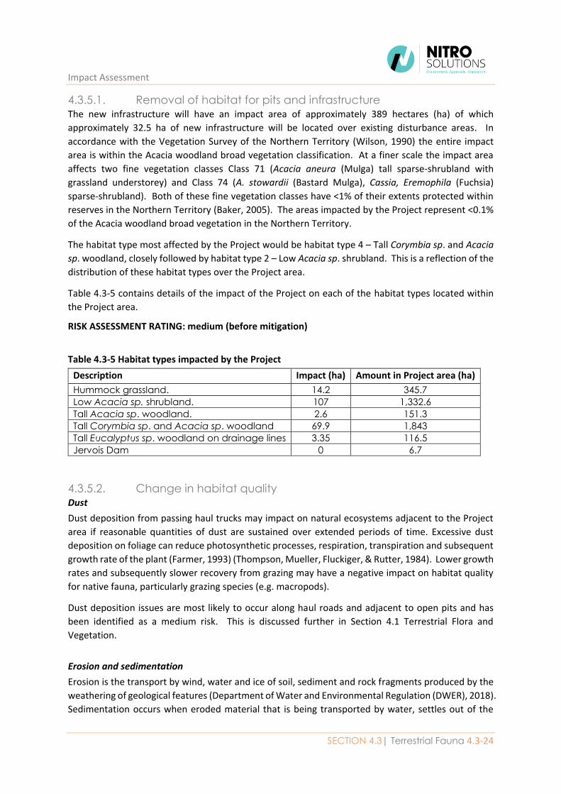
4.3.5.1. Removal of habitat for pits and infrastructure The new infrastructure will have an impact area of approximately 389 hectares (ha) of which
approximately 32.5 ha of new infrastructure will be located over existing disturbance areas. In
accordance with the Vegetation Survey of the Northern Territory (Wilson, 1990) the entire impact
area is within the Acacia woodland broad vegetation classification. At a finer scale the impact area
affects two fine vegetation classes Class 71 (Acacia aneura (Mulga) tall sparse-shrubland with
grassland understorey) and Class 74 (A. stowardii (Bastard Mulga), Cassia, Eremophila (Fuchsia)
sparse-shrubland). Both of these fine vegetation classes have <1% of their extents protected within
reserves in the Northern Territory (Baker, 2005). The areas impacted by the Project represent <0.1%
of the Acacia woodland broad vegetation in the Northern Territory.
The habitat type most affected by the Project would be habitat type 4 – Tall Corymbia sp. and Acacia
sp. woodland, closely followed by habitat type 2 – Low Acacia sp. shrubland. This is a reflection of the
distribution of these habitat types over the Project area.
Table 4.3-5 contains details of the impact of the Project on each of the habitat types located within
the Project area.
RISK ASSESSMENT RATING: medium (before mitigation)
Table 4.3-5 Habitat types impacted by the Project
Description Impact (ha) Amount in Project area (ha)
Hummock grassland. 14.2 345.7
Low Acacia sp. shrubland. 107 1,332.6
Tall Acacia sp. woodland. 2.6 151.3
Tall Corymbia sp. and Acacia sp. woodland 69.9 1,843
Tall Eucalyptus sp. woodland on drainage lines 3.35 116.5
Jervois Dam 0 6.7
4.3.5.2. Change in habitat quality Dust
Dust deposition from passing haul trucks may impact on natural ecosystems adjacent to the Project
area if reasonable quantities of dust are sustained over extended periods of time. Excessive dust
deposition on foliage can reduce photosynthetic processes, respiration, transpiration and subsequent
growth rate of the plant (Farmer, 1993) (Thompson, Mueller, Fluckiger, & Rutter, 1984). Lower growth
rates and subsequently slower recovery from grazing may have a negative impact on habitat quality
for native fauna, particularly grazing species (e.g. macropods).
Dust deposition issues are most likely to occur along haul roads and adjacent to open pits and has
been identified as a medium risk. This is discussed further in Section 4.1 Terrestrial Flora and
Vegetation.
Erosion and sedimentation
Erosion is the transport by wind, water and ice of soil, sediment and rock fragments produced by the
weathering of geological features (Department of Water and Environmental Regulation (DWER), 2018).
Sedimentation occurs when eroded material that is being transported by water, settles out of the
Environmental Impact Statement
4.3-25 Jervois Base Metal Project
water column onto the surface, as the water flow slows (Department of Water and Environmental
Regulation (DWER), 2018).
The proposed Jervois Dam upgrade will increase peak discharges, flood levels and velocities in Unca
Creek downstream of the dam due to the increased spillway capacity. The predicted increases in flood
levels and velocities are typically confined to the Unca Creek channel. The increased levels and
velocities would be no greater than pre-dam levels and velocities, and therefore the impact is not
predicted to change the morphological behaviour of Unca Creek (WRM Water & Environment P/L,
2018). The vegetation clearing and surface disturbance associated with the construction and
operation of the Project can lead to increased run-off, erosion of exposed surfaces and sedimentation
of the waterways; which ultimately affects habitat quality.
Erosion and sedimentation issues are most likely to occur drainage lines and waterways and have been
identified as a high risk. This is discussed further in Section 4.1 Terrestrial Flora and Vegetation.
Noise
The available published literature indicates that man-made noise sources, such as traffic and industry,
may have impacts on fauna species. These impacts may relate to stress or avoidance, interference
with communication, and masking the sounds of predators and prey. In the case of exposure to
extreme levels of noise, temporary or permanent hearing damage may also be possible. Research has
demonstrated that habituation to man-made noise may occur. Whilst an initial response to an
unfamiliar sound may be a startle effect, subsequently familiarisation may occur and the sound may
be ignored, as the sound is not biologically of significance to the species (Larkin, Pater, & Tazik, 1996).
In a literature review on the effects of noise and light from urban development on biodiversity, the
distance at which various bird species were affected by man-made noise was restricted to less than 1
km from the noise source, except in one study where bird presence and breeding was identified as
being reduced at a distance of up to 1.2 km from a major road (> 30,000 vehicles per day) (Newport,
Shorthouse, & Manning, 2014).
The disturbance of fauna by noise is indicated as a very low to low risk. On the basis of the information
above and due to the presence of some conservation significant fauna in the Project area, noise
related emissions management measures may be investigated for prevention of impacts on any
habitat areas. Further information regarding noise emissions from the Project is presented in Section
4.6 Air, Greenhouse Gas and Noise.
Hydrology
The hydrological landscape of an area greatly influences the distribution and type of vegetation
communities found there. Generally, the Project area is within an arid zone that is greatly influenced
by the seasonal availability of water from rainfall within the catchment area. The most prominent
hydrological feature within the Project area is Unca Creek, with its major tributaries and expansive
floodplains. Some of the floodplain in surrounding areas is subject to grazing, with remnant vegetation
concentrated in riparian areas. Some of these areas (habitat type 5) have been indicated as having a
moderate potential to support Groundwater Dependent Ecosystems (GDE).
The impacts of hydrological change may include redirection or drainage of water away from a water
dependent ecosystem, water extraction or flooding of normally dry areas. These changes are
ultimately expressed by the vegetation communities, which may die-back or expand into new areas.
Impact Assessment
SECTION 4.3| Terrestrial Fauna 4.3-26
The E. camaldulensis community along Unca Creek (broad habitat type 5) in the Project area has been
demonstrated to rely on surface water and shallow groundwater (up to 10m below ground) (Horner,
2009). In this case, it is likely there is a strong groundwater influence because Unca Creek flows (on
average) only once in 4 years and has done so since about the 1980’s when Jervois Dam was
constructed (WRM Water & Environment P/L, 2018).
The groundwater levels in the Project area will be influenced by pit dewatering, particularly of Reward
pit (which is located on Unca Creek). The Reward pit will intercept the water table. Groundwater
drawdown is expected to occur at Reward pit and models predict that during operation the drawdown
at Unca Creek (Obs 7) will be over 120 m and between 40 m and 80 m in areas about 200m from the
creek line (including those areas where the creek diversion will run). Post-mining groundwater
drawdown (at the point where Unca Creek meets the Reward pit) will recover very slowly and is not
predicted to level out for about 180 years when it reaches levels that are still 18 - 23 m below existing
levels (CloudGMS, 2018). From an ecological perspective this will likely result in a permanent 1 km
severance of the Unca Creek riparian habitat and wildlife corridor and refuge habitat area. This has
been discussed in more detail in Section 4.1 (Terrestrial Flora and Vegetation) and has been identified
as a high risk.
Connectivity
Habitat fragmentation is a reduction in the continuity of a habitat through disturbance or loss. It often
results in the creation of many smaller habitat patches (with varying degrees of connectivity) in a
previously large and continuous remnant habitat. The survival of species in a fragmented landscape
depends, in part, on their ability to disperse. Discontinuity of habitat areas may present barriers that
can impede or even prevent movement or dispersal between habitats. In and arid environment, the
ecological, value of aquatic systems is significant because they provide reliable sources of water during
drought conditions and connectivity pathways during more favourable periods (Mancini, 2017). Many
bird species use riparian vegetation for food, breeding and shelter (roosting) or regularly visit waters
to drink while spending most time away from the rivers in adjacent habitats.
Similarly, many riparian bird species use the resources of adjacent landscapes on an occasional basis.
There is a distinct possibility that these riparian corridors act as ‘highways’ for landbirds on the move,
which means the rivers may play an important role in connecting bird populations across different
regions in Australia (Mancini, 2017). In the Project area Unca Creek (and major tributary) and the
associated floodplain vegetation connects areas of habitat in and around the Project area to Arthur
Creek (north-east of the Project area).
The Project would retain the vast majority of the Unca Creek corridor, with additional haul-road
crossings of minor drainage lines and two sediment dams (one on Unca Creek and one on the major
tributary to the south). The expansion of the ‘Reward’ pit in the north of the Project area will result
in the redirection of Unca Creek and the removal of 4.31 ha of riparian vegetation. In the short-term
this will result in the severance of the wildlife corridor provided by Unca Creek. In the long-term (>20
years), the redirection of Unca Creek will be rehabilitated and the riparian vegetation will recover to
provide a connectivity pathway in the landscape. This has not been identified as a risk in the risk
assessment.
Environmental Impact Statement
4.3-27 Jervois Base Metal Project
Edge effects
Edge effects occur when previously intact remnant vegetation is cleared in part, leaving a new
boundary of vegetation that becomes exposed to some form of disturbance. Edge effects can include:
the establishment of weeds (Section 4.1, Terrestrial Flora and Vegetation) (which is a medium risk),
immigration of pest fauna species (which is a medium risk) and exclusion of more sensitive native
species, dust deposition (Section 4.1, Terrestrial Flora and Vegetation) (which is a medium risk) and
greater light intensity (which is a very low risk) and noise penetration (which is a low risk).
The construction and operation of the mine would cause ongoing and localised increases in noise,
vibration and light disturbance in habitats directly adjacent to the Project. The extent of this impact
would depend on the distance between the Project and the adjacent habitat, the level of noise and
light emanating from the Project, the type of habitat (dense forest is more resilient) and the hours of
operation. Nocturnal animals would be more susceptible to this disturbance, due to their sensitivity
to light and noise. The mine is expected to operate 24 hours a day, seven days a week for 3 years
(when open cut mining will cease).
Areas of remaining habitat potentially exposed to light and noise pollution are located adjacent to
mine pits, haul roads and processing plant. These areas contain mostly low Acacia sp. shrubland and
some Corymbia and Acacia sp. woodland habitats (sparse vegetation) that are easily penetrated by
light and noise. It is anticipated that more sensitive, nocturnal fauna species inhabiting these
woodland areas would be affected by light and noise issues, including native marsupials and rodents.
RISK ASSESSMENT RATING: medium (before mitigation)
4.3.5.3. Impacts to threatened fauna Surveys recorded two species of conservation significance; Dromaius novaehollandiae (emu) and
Rattus villosissimus (long-haired rat) within the Project area. Another four conservation significant
fauna species were indicated as ‘likely’ to occur within the Project area:
• Australian bustard (Ardeotis australis) – Near threatened (TPWC Act)
• Red-tailed black cockatoo (Calyptorhynchus banksii samueli) – Near threatened (TPWC Act)
• Grey honeyeater (Conopophila whitei) – Data deficient (TPWC Act)
• Australian painted snipe (Rostratula australis) – Endangered (EPBC Act), Vulnerable (TPWC
Act).
Three of these species have very broad habitat requirements and may utilise any of the mapped
habitat types located in the Project area: emu, long-haired rat and Australian bustard. The removal
of 197 ha of potential habitat in the Project area is not considered to have a significant impact on
these species, which will be able to utilise areas of habitat that are not impacted by the operations in
the Project area and surrounding environment.
The Red-tailed black cockatoo is associated with “Tall Corymbia sp. and Acacia sp. woodland” and “Tall
Eucalyptus sp. woodland on drainage lines”. Approximately 69.9 ha of potential habitat for the species
would be removed by the Project, but this is not anticipated to have a significant impact on the species
due to the amount of potential habitat within the Project area (1,843ha) and surrounds.
The Grey honeyeater is associated with “Tall Acacia sp. woodland” and “Tall Corymbia sp. and Acacia
sp. woodland”. Approximately 2.6 ha of potential habitat for the species would be removed by the
Project, but this is not anticipated to have a significant impact on the species due to the amount of
potential habitat within the Project area (151.3 ha) and surrounds.
Impact Assessment
SECTION 4.3| Terrestrial Fauna 4.3-28
The Australian painted snipe is associated with potential habitat at Jervois Dam, which will not be
removed or altered during the lifetime of the Project. No significant impact is anticipated for this
species.
RISK ASSESSMENT RATING: low (before mitigation)
4.3.5.4. Impacts to migratory fauna There were no listed migratory species recorded during surveys, however, the following species were
considered as likely or potentially occurring when conditions are suitable:
• Fork-tailed swift (Apus pacificus)
• Sharp-tailed sandpiper (Calidris acuminata)
• Caspian tern (Hydroprogne caspia)
• Glossy ibis (Plegadis falcinellus)
• Common sandpiper (Tringa hypoleucus); and
• Common greenshank (Tringa nebularia).
The Jervois Dam provides potential habitat for migratory aquatic or wading species during the
migration period, when there is water in the dam. No listed migratory species were recorded in the
Project area in significant numbers to indicate any important feeding or breeding habitat. The Project
does not propose to remove or reduce the Jervois Dam, which will remain functional as habitat for the
life of the Project. No significant impact on Migratory species is expected to occur as a result of the
Project and the proposed action will not be inconsistent with Australia’s obligations under:
(i) The Bonn Convention
(ii) CAMBA
(iii) JAMBA; or
(iv) An international agreement approved under subsection 209(4) of the EPBC Act.
RISK ASSESSMENT RATING: low (before mitigation)
4.3.5.5. Introduction of exotic fauna The field surveys have recorded the presence of a variety of exotic fauna, namely:
• Bos taurus (domestic cattle)
• Mus musculus (house mouse)
• Oryctolagus cuniculus (rabbit); and
• Felis catus (feral cat).
The EPBC Act lists rabbits and feral cats as ‘key threatening processes’ to biodiversity due to their
impact on wildlife and the landscape (TSSC 2009).
Most feral species are assumed to have resident populations in in the Project area and surrounds,
though their abundance is likely to vary with the seasons. Feral animals threaten populations of native
wildlife in two main ways: direct predation (for example by foxes, cats and dogs); or competition for
limited resources (rabbits, rodents and pigs). As most of the Project area contains patchy remnant
vegetation surrounded by agricultural uses, feral and pest animals already have access to (and have
been recorded within) most habitat areas.
Activities associated with the Project may provide increased refuge and scavenging resources (e.g.
discarded food scraps) for introduced fauna species. Feral animals would be discouraged within the
Environmental Impact Statement
4.3-29 Jervois Base Metal Project
Project area by maintaining a clean, rubbish-free environment, and appropriately qualified persons
would be engaged to undertake pest animal monitoring within the Project area. Feral animal control
strategies (e.g. baiting, trapping) would be implemented in accordance with relevant standards to
maintain low abundance of declared animals.
RISK ASSESSMENT RATING: medium (before mitigation)
4.3.5.6. Fauna mortality Clearance Activities
Fauna present in the areas proposed to be cleared would be at risk of injury or fatality during clearance
activities. The removal of habitat would also result in displacement of mobile species (such as birds
and mammals) to similar habitats in the surrounding area. This was not identified as a risk in the risk
assessment process. All of the fauna habitats mapped in the Project area occur more extensively
within the surrounding landscape.
A staged and controlled land clearance practices will be adopted for the Project. Land clearance will
occur progressively over the life of the mine and only in areas required for mining activities within the
following year. The habitat to be cleared will be subject to targeted pre-clearance surveys for native
fauna and breeding places. Fauna or breeding places identified during the pre-clearance surveys would
be managed to minimise injury to resident fauna during clearance activities.
Vehicle Strike
Vehicle movements and road haulage has the potential to result in fauna mortality through vehicle
strike and has been identified as a medium risk. Road mortality has been implicated in the decline of
wildlife populations, including species of conservation significance (Rowden, Steinhardt, & Sheehan,
2008) (Taylor & Goldingay, 2004).
The main access road for the Project will make use of an existing road (Lucy Creek Access Road) and is
located through sparsely wooded areas where visibility on the adjoining road shoulders is good. This
will help to minimise the risk of vehicle strike to native fauna. There is one location, however, where
the main access road would cross the Unca Creek major tributary and associated riparian woodlands,
which serves as a movement corridor and refuge habitat for native fauna. It is possible that a higher
occurrence of vehicle strike may affect this area. Vehicle movements within the Project area (e.g.
from mine pits to the processing plant) will be subject to lower speed limits, which will assist to
minimise the risk of fauna vehicle strike in these areas.
Other incidental deaths
There are other activities within the Project area that have the potential to result in a fauna mortality,
for example:
• Entrapment of fauna within mine pits
• Entrapment of fauna within drill holes
• Falling down unstable slopes
• Electrocution in transmission lines; and
• Drowning in dams.
These incidents have been identified as a low risk.
RISK ASSESSMENT RATING: medium (before mitigation)
Impact Assessment
SECTION 4.3| Terrestrial Fauna 4.3-30
4.3.5.7. Hazardous material Wildlife ingestion or exposure to hazardous material at the Project site is primarily a risk at tailings
dams (which has been identified as a high risk) and through the escape of contaminated water into
creeks and water supplies (which has been identified as a medium risk). Effects can be immediate or
cumulative. Consumption of contaminated water by fauna can cause:
• Death or harm
• Disruption to breeding success; and
• Local increase in predators/scavengers to ill/dead fauna.
The potential release of contaminants into the environment is discussed in Section 4.1 (Terrestrial
Flora and Vegetation). Exposure of fauna to hazardous material at the tailings dams is a potential
impact primarily to birds that are attracted to large bodies of water. At the Project site, the tailings
dams are located next to the processing plant and are surrounded by roads and other noisy
infrastructure that will assist in deterring birds from utilising tailings dams. The design of the tailings
dams will also follow best practice for the Northern Territory to be less attractive to birds. The Jervois
Dam in the north-west of the will provide a more appropriate habitat for birds and act to entice them
away from the tailings dams.
RISK ASSESSMENT RATING: medium (before mitigation)
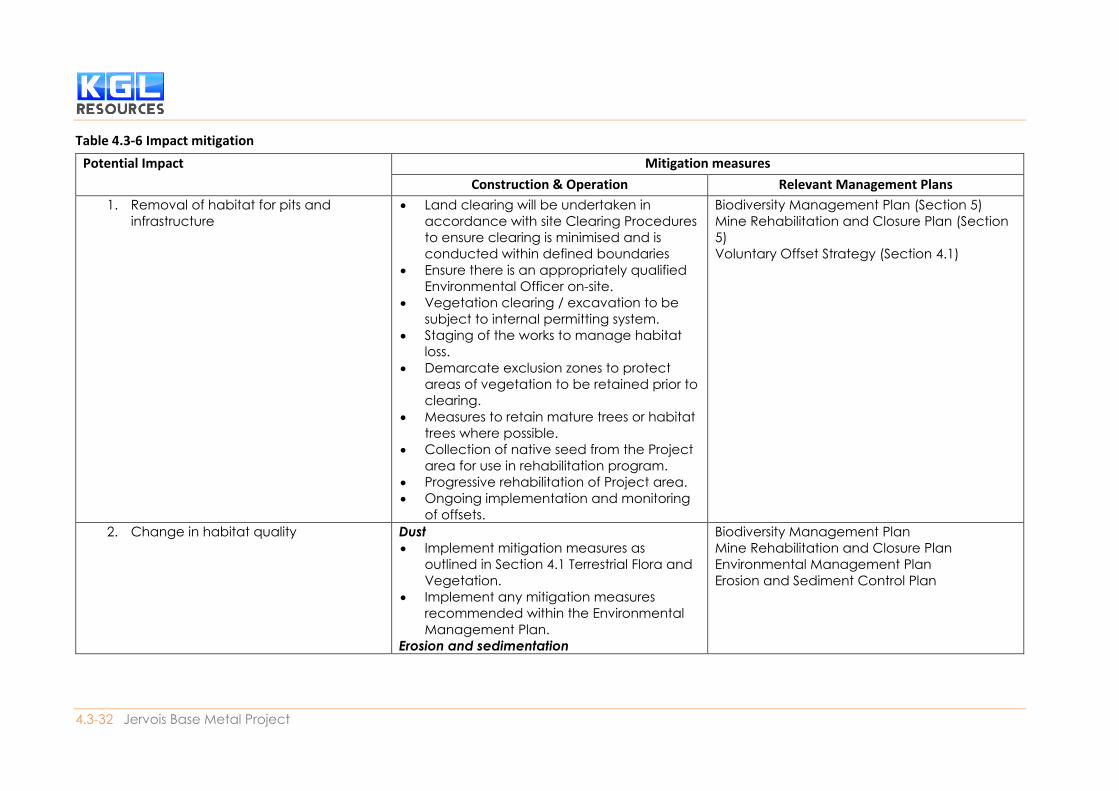
4.3.6. Mitigation measures The mitigation strategy for the Project has focused on a hierarchy of:
1. Avoidance;
2. Minimisation;
3. Mitigation; then
4. Offset residual impacts.
The avoidance or minimisation of adverse impacts is most relevant to the design phase of the Project,
where information collected through desktop analysis and field surveys can be incorporated into the
planning and preliminary engineering work. Mitigation of impacts (including the implementation of
monitoring and management plans) is most relevant to the construction and operational phases of
the Project. Table 4.3-6 provides a summary of the mitigation strategies for the Project, with a brief
description of potential impacts and measures that can be implemented at each stage in the life of
the Project.
Residual impacts, after the implementation of the mitigation strategy, may be required to be offset in
accordance with Commonwealth and State approval conditions. Offsets proposed for the Project are
discussed in Section 4.1.
Measures to avoid and minimise impacts
The Project area covers approximately 3,800 ha. The total disturbance footprint for the Project will be
approximately 970 ha, of which approximately 163 ha has been previously disturbed by historic mining
activities. The Project will make use of existing infrastructure as far as possible, to reduce the
development footprint. The majority of new infrastructure to be located on the existing infrastructure
footprint may include:
• Mine pits
• Roads and access tracks
Environmental Impact Statement
4.3-31 Jervois Base Metal Project
• Jervois Dam and spillway
• Processing plant & infrastructure
• Tailings Storage Facility (TSF)
• Waste rock dumps
• ROMs; and
• Mining village / camp.
Impact mitigation
Impact mitigation associated with the Project has been detailed in Table 4.3-6Error! Reference source
not found.. Due to the length of time that the mine is expected to operate and the ongoing need for
management of terrestrial flora during the operation of the mine, operational mitigation measures
are best presented in ‘Monitoring and Management Plans’.
4.3-32 Jervois Base Metal Project
Table 4.3-6 Impact mitigation
Potential Impact Mitigation measures
Construction & Operation Relevant Management Plans
1. Removal of habitat for pits and
infrastructure
• Land clearing will be undertaken in
accordance with site Clearing Procedures
to ensure clearing is minimised and is
conducted within defined boundaries
• Ensure there is an appropriately qualified
Environmental Officer on-site.
• Vegetation clearing / excavation to be
subject to internal permitting system.
• Staging of the works to manage habitat
loss.
• Demarcate exclusion zones to protect
areas of vegetation to be retained prior to
clearing.
• Measures to retain mature trees or habitat
trees where possible.
• Collection of native seed from the Project
area for use in rehabilitation program.
• Progressive rehabilitation of Project area.
• Ongoing implementation and monitoring
of offsets.
Biodiversity Management Plan (Section 5)
Mine Rehabilitation and Closure Plan (Section
5)
Voluntary Offset Strategy (Section 4.1)
2. Change in habitat quality Dust
• Implement mitigation measures as
outlined in Section 4.1 Terrestrial Flora and
Vegetation.
• Implement any mitigation measures
recommended within the Environmental
Management Plan.
Erosion and sedimentation
Biodiversity Management Plan
Mine Rehabilitation and Closure Plan
Environmental Management Plan
Erosion and Sediment Control Plan
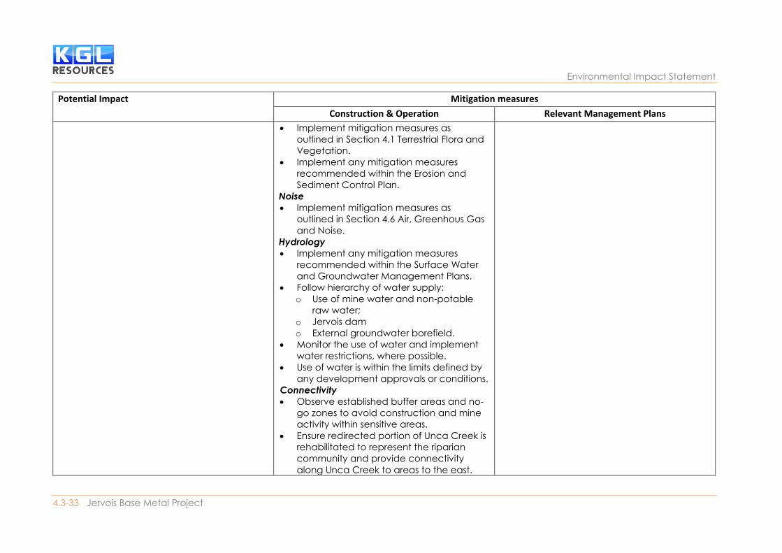
Environmental Impact Statement
4.3-33 Jervois Base Metal Project
Potential Impact Mitigation measures
Construction & Operation Relevant Management Plans
• Implement mitigation measures as
outlined in Section 4.1 Terrestrial Flora and
Vegetation.
• Implement any mitigation measures
recommended within the Erosion and
Sediment Control Plan.
Noise
• Implement mitigation measures as
outlined in Section 4.6 Air, Greenhous Gas
and Noise.
Hydrology
• Implement any mitigation measures
recommended within the Surface Water
and Groundwater Management Plans.
• Follow hierarchy of water supply:
o Use of mine water and non-potable
raw water;
o Jervois dam
o External groundwater borefield.
• Monitor the use of water and implement
water restrictions, where possible.
• Use of water is within the limits defined by
any development approvals or conditions.
Connectivity
• Observe established buffer areas and no-
go zones to avoid construction and mine
activity within sensitive areas.
• Ensure redirected portion of Unca Creek is
rehabilitated to represent the riparian
community and provide connectivity
along Unca Creek to areas to the east.
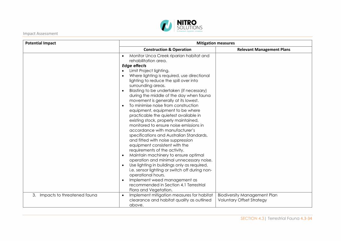
Impact Assessment
SECTION 4.3| Terrestrial Fauna 4.3-34
Potential Impact Mitigation measures
Construction & Operation Relevant Management Plans
• Monitor Unca Creek riparian habitat and
rehabilitation area.
Edge effects
• Limit Project lighting.
• Where lighting is required, use directional
lighting to reduce the spill over into
surrounding areas.
• Blasting to be undertaken (if necessary)
during the middle of the day when fauna
movement is generally at its lowest.
• To minimise noise from construction
equipment, equipment to be where
practicable the quietest available in
existing stock, properly maintained,
monitored to ensure noise emissions in
accordance with manufacturer’s
specifications and Australian Standards,
and fitted with noise suppression
equipment consistent with the
requirements of the activity.
• Maintain machinery to ensure optimal
operation and minimal unnecessary noise.
• Use lighting in buildings only as required,
i.e. sensor lighting or switch off during non-
operational hours.
• Implement weed management as
recommended in Section 4.1 Terrestrial
Flora and Vegetation.
3. Impacts to threatened fauna • Implement mitigation measures for habitat
clearance and habitat quality as outlined
above.
Biodiversity Management Plan
Voluntary Offset Strategy
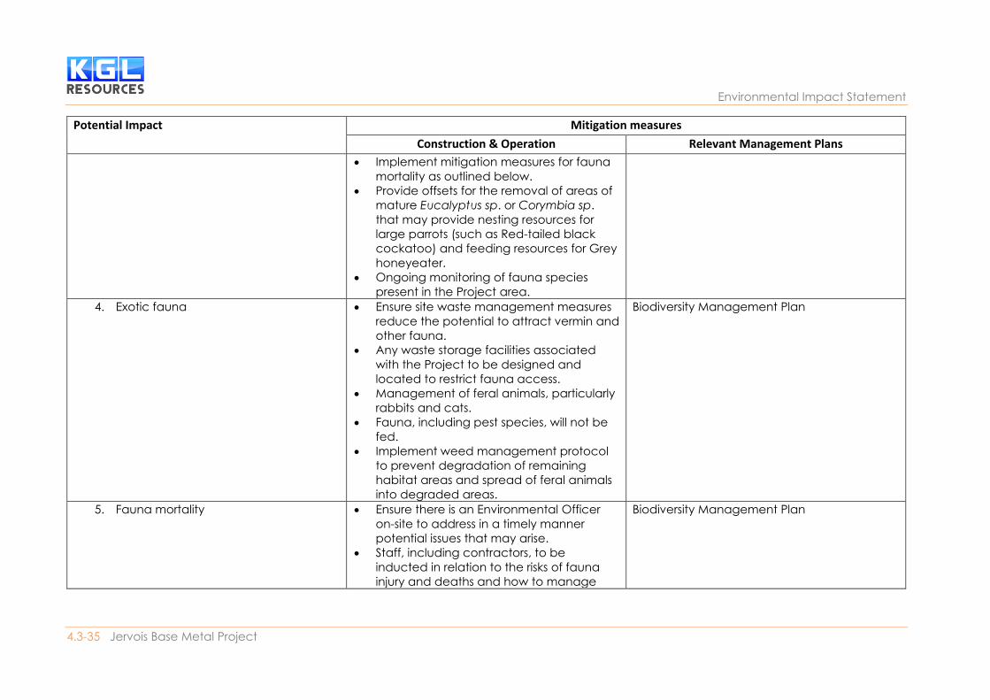
Environmental Impact Statement
4.3-35 Jervois Base Metal Project
Potential Impact Mitigation measures
Construction & Operation Relevant Management Plans
• Implement mitigation measures for fauna
mortality as outlined below.
• Provide offsets for the removal of areas of
mature Eucalyptus sp. or Corymbia sp.
that may provide nesting resources for
large parrots (such as Red-tailed black
cockatoo) and feeding resources for Grey
honeyeater.
• Ongoing monitoring of fauna species
present in the Project area.
4. Exotic fauna
• Ensure site waste management measures
reduce the potential to attract vermin and
other fauna.
• Any waste storage facilities associated
with the Project to be designed and
located to restrict fauna access.
• Management of feral animals, particularly
rabbits and cats.
• Fauna, including pest species, will not be
fed.
• Implement weed management protocol
to prevent degradation of remaining
habitat areas and spread of feral animals
into degraded areas.
Biodiversity Management Plan
5. Fauna mortality • Ensure there is an Environmental Officer
on-site to address in a timely manner
potential issues that may arise.
• Staff, including contractors, to be
inducted in relation to the risks of fauna
injury and deaths and how to manage
Biodiversity Management Plan
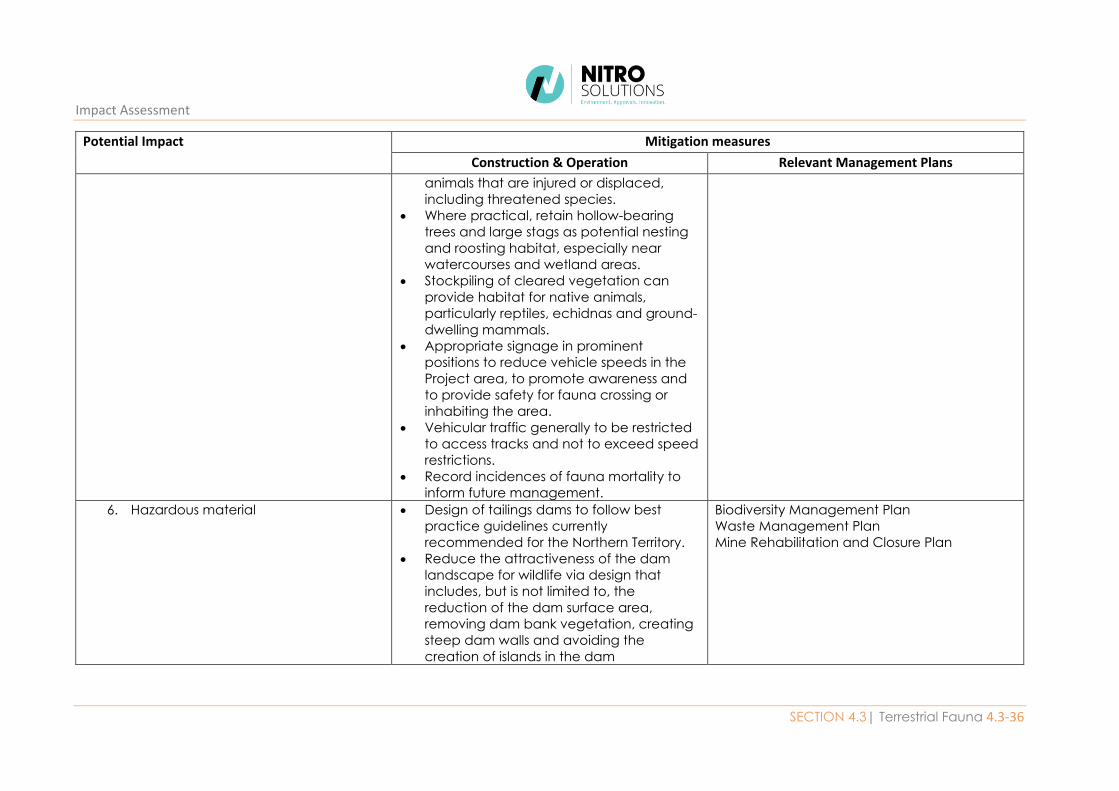
Impact Assessment
SECTION 4.3| Terrestrial Fauna 4.3-36
Potential Impact Mitigation measures
Construction & Operation Relevant Management Plans
animals that are injured or displaced,
including threatened species.
• Where practical, retain hollow-bearing
trees and large stags as potential nesting
and roosting habitat, especially near
watercourses and wetland areas.
• Stockpiling of cleared vegetation can
provide habitat for native animals,
particularly reptiles, echidnas and ground-
dwelling mammals.
• Appropriate signage in prominent
positions to reduce vehicle speeds in the
Project area, to promote awareness and
to provide safety for fauna crossing or
inhabiting the area.
• Vehicular traffic generally to be restricted
to access tracks and not to exceed speed
restrictions.
• Record incidences of fauna mortality to
inform future management.
6. Hazardous material • Design of tailings dams to follow best
practice guidelines currently
recommended for the Northern Territory.
• Reduce the attractiveness of the dam
landscape for wildlife via design that
includes, but is not limited to, the
reduction of the dam surface area,
removing dam bank vegetation, creating
steep dam walls and avoiding the
creation of islands in the dam
Biodiversity Management Plan
Waste Management Plan
Mine Rehabilitation and Closure Plan
4.3-37 Jervois Base Metal Project
Operational management and monitoring plans
The Jervois Mine will be required to have a Mining Management Plan (MMP) under the Mining
Management Act 2001. The primary purpose of a Mining Management Plan (MMP) is to formalise the
actions to be taken and strategies to be implemented, that combined, will manage impacts to the
environment to acceptable and sustainable limits over both the short and long-term. The MMP has
several components or sub-plans relating to the management of various issues. The Biodiversity
Management Plan (BMP) has been developed to provide a clear and concise outline of the actions and
methods required to mitigate likely impacts on biodiversity including:
• Procedures to be adopted during vegetation clearing, including wildlife rescue procedures;
• Weed and feral animal management; and
• Mitigation of potential impacts on rare, threatened species.
In addition to this BMP, the management of biodiversity is addressed in several other sub-plans
including:
• Environmental Management Plan;
• Erosion and Sediment Control Plan;
• Water Management Plan;
• Waste Management Plan; and
• Bushfire Management Plan.
These sub-plans will consolidate information regarding the management of specific issues during the
operation of the mine and provide for ongoing reference over the life of the mine. These management
sub-plans will be kept on site for continual reference. The BMP forms part of the MMP for the Project
and is considered to be a working document. It will be updated following formal assessment of the EIS
by the NT EPA, and by Department of Mines and Energy through the mine authorisation process. The
BMP is provided as part of this EIS in Section 5.
4.3.7. Decommissioning of the mine At the end of the mine life, it is expected that the mine site will be rehabilitated to be fit for the
nominated future land use. Currently the Project area is part of the Jervois Pastoral Lease and has
been used historically for mining and a low level of cattle grazing. It is anticipated that the post-mining
land form will remain suitable for cattle grazing, with a combination of grassland and wooded areas
representing the vegetation communities currently extant in the Project area.
Rehabilitation will be performed in accordance with contemporary accepted industry best practice
and conducted in accordance with an approved MMP. KGL has prepared a Mine Rehabilitation and
Closure Plan. The MRCP will be a dynamic document that is reviewed regularly to ensure the plan
remains relevant to the activities being undertaken and planned to be undertaken. The MRCP will
include a post-closure monitoring and reporting program to evaluate rehabilitation success and
progress toward achieving closure objectives and contingency measures to be implemented in the
event that monitoring demonstrates that rehabilitation closure objectives are not being met.
Impact Assessment
SECTION 4.3| Terrestrial Fauna 4.3-38
4.3.8. Conclusions The Jervois Base Metal Project Environmental Impact Statement (EIS) Terms of Reference has
identified terrestrial fauna as a preliminary environmental factor that may be impacted by the Project.
In order to better understand the terrestrial fauna values of the Project area, a number of ecological
investigations were undertaken by Low Ecological Services P/L between 1985 and 2018. The studies
included desktop assessment (i.e. interrogation of spatial databases and reviews of relevant literature)
and field work involving on-ground fauna surveys in 1999, 2012, 2013, 2017 and 2018. General fauna
survey methodology follows the NT EPA “Guidelines for Assessment of Impacts on Terrestrial
Biodiversity” (NT EPA, 2013). Additional targeted surveys were conducted for fauna species of
conservation significance listed under the TPWC Act that were identified in database searches as
potentially occurring within the Project area.
Based on survey results, six habitat types have been mapped over the entire Project area (3,800 ha).
The most common habitat type in the Project area is “Tall Corymbia sp. and Acacia sp. woodland”
followed by “Low Acacia sp. shrubland”. Two fauna species listed as near threatened under the
Territory Parks and Wildlife Conservation Act (TPWC Act), emu (Dromaius novaehollandiae) and long-
haired rat (Rattus villosissimus), were recorded during on-ground surveys. There were no listed
migratory species recorded during fauna surveys, although the Jervois Dam was identified as potential
habitat for migratory species that may be in transit over the Project area. The Project area contained
four exotic fauna species (cat, rabbit, house mouse and cattle) but was generally considered to be in
good condition considering a long history (since 1929) of mining and the presence of some existing
mining infrastructure.
The construction and operation of the mine is associated with a number of potential impacts to the
floristic values of the Project area, including:
• Removal of habitat for pits and infrastructure
• Change in habitat quality
• Impacts to threatened fauna
• Impacts to migratory fauna
• Introduction of exotic fauna
• Fauna mortality; and
• Hazardous material.
A risk assessment process as described in AS/NZS 4360 (1999) and ISO 31000 (2009) has been
undertaken for each impact before the application of any mitigation measures. Risk levels for impacts
to fauna values of the Project area ranged from low to high. The application of mitigation measures
will ameliorate the level of risk to an acceptable level for the Project.
The Jervois Mine will be required to have a Mining Management Plan (MMP) under the Mining
Management Act 2001. The primary purpose of a Mining Management Plan (MMP) is to formalise the
actions to be taken and strategies to be implemented, that combined, will manage impacts to the
environment to acceptable and sustainable limits over both the short and long-term. The MMP has
several components or sub-plans relating to the management of various issues. The Biodiversity
Management Plan (BMP) has been developed to provide a clear and concise outline of the actions and
methods required to mitigate likely impacts on biodiversity including:
• Procedures to be adopted during vegetation clearing, including wildlife rescue procedures;
• Weed and feral animal management; and
Environmental Impact Statement
4.3-39 Jervois Base Metal Project
• Mitigation of potential impacts on rare, threatened species.
Other plans will also have components addressing biodiversity, such as the Environmental
Management Plan, Erosion and Sediment Control Plan, Water Management Plan, Waste Management
Plan, Bushfire Management Plan and Mine Closure and Rehabilitation Plan. The BMP forms part of
the MMP for the Project and is considered to be a working document. It will be updated following
formal assessment of the EIS by the NT EPA, and by Department of Mines and Energy through the
mine authorisation process. Further, a voluntary offset strategy has been proposed for the removal
of some ecological values considered to be of local significance in the ecological assessments
completed for the Project.