impact of dredging in the tampa bay estuary
TRANSCRIPT

Lmhact of Dredging in the mrpz Bay EStrrary, 1876 - 1976, Roy R. Lewis, IT1 . . . . . . . . . . . . . - - . . . . . . . . . . -3 : - 55
PROCEEDINGS
SECOND ANNUAL CONFERENCE New Orleans, Louisiana
November 17' - 28. 1976
Ti E COASTAL SOC% E W
TIME - STRESSED COASTAL ENVI RQ1VMEbiPS.- ASSESS-MENT and FUTURE ACT!OAI
Pubiished by
THE CGASTAL socr ETY 3426 Noflh Wash tngton Boulevard
Arlington, Virginia 22201

Lewis LG'rlCT OF D R E X I X G I X TEE T L V A M Y EST'JhRY, 1876-1976 2
Roy K- Lewis, 111
Professor of Biology Billsborough Community College Tanpa, Florida
Tampa Bay is an estuary located on t h e west coast of Florida. One- sixth of the state's population lives in the three counties bordering i x s shores.
During the last 100 years four major types of dredging have impacted the bay: c'namei deepening, maintenance & e d g i n g , sheii dredging, and dredg ing for landfill construction. These %pacts range from rhe economic benefrit provided by chamel and port construction for wnat i s now the eighth largesr port in the nation to the environmental damage caused by dredging to create over 5,000 ha of l a d f i i l in rhe bay for residential, commercial, and dredged material disposal use. These landfills Lave resulted i n the loss of 44% of the original narine wetlands Bordering Taws Bay.
Becenr environmental concerns have halted l andf i l l dredging and severely restricted maintenance dredging. Research on s h e l l dredging in :he bay indicate ntnimal 5mpsc; if carefully controlled. Few chamel deepening an6 open water disposal of 55,000,000 m3 of dredged naterial is planned as parr of the Tzmpa &r>or Deepeaing Project, now in pro- gress. Thfs project has uidergone fnteasive rev5ew and aodification as a result of envrironmental concern by both citizens and scientists.
Introduction
Duzing the f96Ds, the popillation of Florida increased 37% from 4.9 m i l l i o n to 6.8 million, while the United States as a wnole shoved only a 13% increase. Three out of four of chese new residents migrated from orher s;ates. The 1976 population is e s r h e e d to be 8.7 miiiion %<th 74% of this number living on 28% of the laad area, the coastal zone (Division of State Planning, 1976). O f the 60 estuarine study areas exmieed by XcNulty et aL. (1972) Tampa 3ay is second only to the Florida Bay system in size (Fig. 1). One-sixth of the state's popula- tion l ives in the three counties bordericg The bay, Siflsborol;gh, P i n e l l a s , and mnatee .
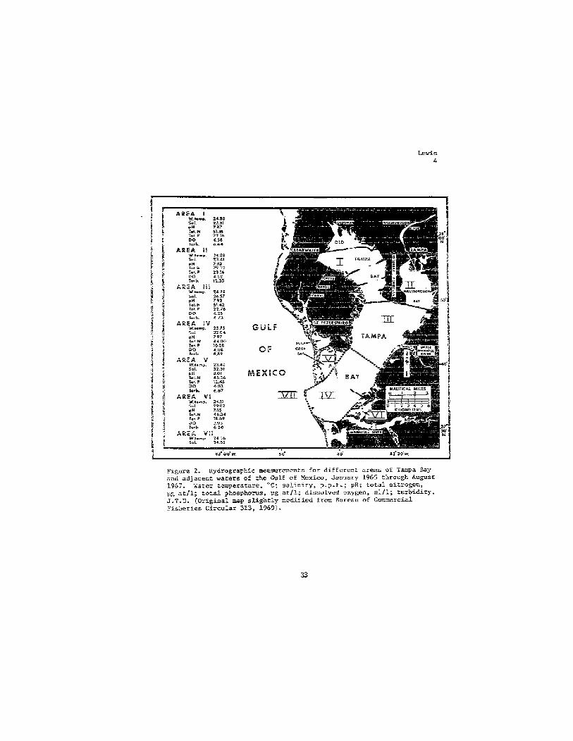
Tampa Bay i s divided into six sub-areas (Fig. 2 ) : Old Tampa Bay, Billsborough Say, Upper Tanpa Bay Proper, Lower Tampa Bay Proper, Boca Ciega Bay, an6 Terra Ceia Bay. Xepresentat5ve physical and chemical parameters fo r these sub-areas are also given i n Figure 2. Oison and Korrili (1955). u s h g as a basis a 1943 charr, determined the coral area of the bay ro be 93,503 ha k5th a shoreline of 32G h.. A s noted by Simon (1974) alterations to the bay since that ?%me have uade these figures obsolere. For example Olson and Norrill (1955) l i s t the shore- l i ze o f B O C ~ Ciega Bay as 42 .3 k c trhlle S h o n (19741 usicg a 1471 chart found it to be 199.6 h. The author is present ly updating che work of Olson and Xorrl l! . !1955! usicg 1976 charts. P.ese s a e authors noeed

L e w i s 3
G U L F
O F
-.
Figure 1. The Tampa Bay Estuary, Floridz.
Lewis 4
Figure 2. Hydrographic mesurcmeu:s for differen: areas of Tanpa Bay and adjzcen: warers of the G u l f of Mexico, Jaxuary 1965 through August 1957. k.a:cr :cmpersrnre, "C; salmrry, p - p . : . ; >I!; total ni t rcgcc, pg at/l; roral phosphorus, .;g at l l ; d:ssolvcd oxygen, ml/l; tur'oidiry, J.T.U. (Or ig ina l map s l ightly modified, from Bureau of Commercial Fisheries C i r c u l a r 313, 1969) .

that " T s q J a Bzy j.y read5lg be clssssd as a shailmsr Sody cf wz:er sL?ce the modal Gepth is 5a; 9.7 fz a-,C 9G% o f fts area has a depth less 'c1b.n 22 fr" C9.7 ft = 3.C m, 22 f: = 6.7 m).
T:?e sc5rropical clizzte or' the Tenpa 32y area s+?cr;s 30;h trop- ical sagzove forests arrd tenperate tidal marshes along :he shores of zhe est.acry. tntez;: zeasuraertts, d e v%;-tl-. the assiis2ncc 05 the C . S . Geolog ics l Survey, Tzriga office, show 5 , 5 3 3 ha o f these iatertidai s r i a e comucities remaining 5n xhe 3ay. T5is represenzs a 441 Cecline f ro= those presen? <n is76 z e w i s , uii2~3:5lisheL). The vahe of rhese comrcunities in tne pro6uction of detritus azd thei r role in marine
, pro6ucrivizy in souch FlorTddz estuaries has be@ w e l l 2ocumenzet by Heald (1971), Cl6m (1971), and Odnm ard Seal8 (iS72:. Submerged vege- rsrio? i n the eesuary cor?sists of f ive species of seagrasses 2nd 216 species o f sigae. Taylor (1971) estimated 8,500 ha of fay bottom was vegetated hy sezgrasses and conspicuous Senthfc algae.
Sy'kes and ?inucaze (1966) report twenty-three species of major i n p o r t a c e in Gulf of Mexico c m e z c i a l fisheries occur i n T w a Bay during immaturity. Old Tan?pa Zay harbored greater n u b e r s of these species S k n any o ther area. Sillsborough Bay, s w l a r Ln salinity regzw, harbored fever i ~ p o r r u l t specfes than any ocher area.
The reeder is r e f e r r & to Olsor and k r r i l l (19553, Tzylcr !1973), 2nd Sincn (1974) for compie~e litera:ure reviews a d deta i led discus- sfoas on the present status of the estery .
During the last 100 yea~s four ~ j o r zypes of dredging have im- pzcred eke bay: channel deersea*, -&atmace d r d g i z g , &ell dredgkg, and dredging f oz landfi l l .
Channel Deepening
Tampa Bay hhs provided protected anchorage for sh ips since ehe 16th cenrury, -including vessels carryfng Fonce de Leon and Eernando d e Soco (Lo'nse er 21., 1959)- The shallow depth weye sufffc5en: u~til rhe drafts of vessels had increased and deeper channels than r?aturaily exisred were n5cesszry. Since dredging f irs t began In Tampa Bay in LSSO, LC7 km of charnels have Leen c-isszed <Taylor, 1973). The naterisl dredged f r o m these channels ;la% Seen placed adjaceat r o the channeis as subzerged or emergene: spoii areas {Fig. 3 ) , or used as landfill for shoreline developnent (Flg. 4 , 5, 6, 7 ) . As can be seen LL these photographs tbAs type of dredging has zroduced large turbidity plumes from t incontrol led overf iow in s p o i l areas aild cutterfiead disturbance of t h e sediments. Illegal Eilling of submerged land (under the juris- diction or' t:?e State of Piorida) occurred routinely in the 1150s szr,d penalties w e r e m i h i . Oftea eke illegalil- fiLled lazd was sold to ?he Gredging company after filling ai. resold at a good p r o f i t far in excess of the fine o r cost of dredging. The f i l l i n g of Redfish Creek in Lower T a p a 8ay in 1969 ( F i g . 4 ) is an exampie where the land was filled

Figure 3- Dredgfng at Port Manatee, Lower Tzmpa Bay, September, 1968. The dredge and the channel it is cutting can be seen at t h e arrow. The di ' ed port area and the undisturbed R e d f i s h Creek ten- grove forest (upper right comer) are at the top of the picture.
without permits and the fill left in p b c e insread of being ordered removed. The area is s t i l l severely damaged in 1976 and it is unlikely i t w i l l ever recover. This blatant d5sregard for dredge and fill permit procedures has finally led to more recent i l l e g a l f i l ls being ordered removed at the expense of the dredger. This klnd of enforcement has significantly reduced the incidence of i l l egal f i l l i n g h Tampa Bay.
Sherk (1971) has discussed i n d e t a 5 l the effecrs of suspended and deposited sediments on estuarine organisms. These include loss of habitat, decrease in euphotic zone depth, (increased) oxggen demznd, nutrient sorption and release, (decreased) primary productivity, benthic ceamunity disruptton, direct mortality and other gross effects. The reader is referred to thfs source for more detailed 5nformation. T;nSortunately, little research has been done on the effects of channel dredging and s p o i l disposal in Tampa Bay. Complete and permanent destruction of benthic cwmrunitles and i n t e r t i d a l marshes and mangrave forests is an obvious result ( F l g . 3, 4, and 5 ) . Most of the effects discussed by Sberk (1971) are less obv?ous and little studied. Taylor (1973) descrzbes five sediment groups for Tampa Bay: eeep ship channel. soft spoil, firm spoil, soft =dredged, and f irm undredged. The firm bottoms supported the largest umber OF individuals and species while the ship channel supported the least . Results from she l l dredging

Figure 4 . Dredging at Port Manatee, Lower Tampa Bay, June 1970. The chvlnel creation and f i l l i n g for the port is complete. Excess f i l l has been placed in the Redfish Creek mangrove forest, to ta l ly destroy5ng it, and additional f i l l can be seen smothering rhe offshore seagrzss meadows. No permits were issued for this work.
research (discussed later) indicate rapid recovery of bentMc c-ni- ties disturbed by small, target s p e c i f i c dredghg projecrs. Some recovery in some older submerged spoil disposz l sires is evident from the data of Taylor (1973). How long t h i s took is not laown. Recovery o f disturbed seagrass meadows is extremely slow after dredging (Godcharles, 1971) or even motor boat prop damage (Zieman, 1976). No complete survey of the area occupied by seagrass meadows in Tampa Bay has ever been made, thus it is impossible to determine at the present time what damage has been done to this valuable habitat. The work of Taylor and Saloman (1968) in Boca Ciega Bay assumed a standing crop of 798 kg/ha (dry weight) of seagrasses over t h e total fill area o f 1, 400 ha, even though some of the f i l l e d areas were bare. This was felt to be a reasonable compromfse sfnce actual measurenaents of the area of seagrass meadows lost w a s probably not feasible.
An additional problem of open water spoil disposal from channel deepening is the possible impedance of nesmal circulation in Tampa Bay. In a report prepared by the Federal Water Pollution Control A d m h i s t r a - Z i o n on water quality problems in IIillsborwgh Bay (F.W.P.C.A., 1969) the following recommendation w a s made:

Lewis 8
Figure 5 . Port Manatee, Lcwer Tampa Bay, Xovember 1972. Arrows indicate the extear of smothered seagrass meadows offshore of the f i l l f d area tkar was previously Redfish Creek.
A master plan for dredghg and filling ia IIiUsborough Bay should be developed by the pertinent federal, state, and l o c a l operating and regulatory agencies, Certain spoil i s l a n d s , resulting from charm@l dredging, which impaTr circularion, flushing and exchange in the Bay, shodd be removed and mainsenance s p o i l dredging m a t e rlal should not b e deposited in the Bay.
This recwrmendation resulted f r o m dye rracer studies fn cbnjunction with studies on the impact of sewage pollution in Bfllsborough Bay, where most of the impeded circulation problems were believed to &st. This recommendation was endorsed by the U.S. Army C o r p s of Engheers (1970) rin planning for t h e Tampa Ehrbor Deepenkg Project and a study was undertaken by the U.S . Geological Survey jointly funded by the Tampa Port Authority and the Corps of Engineers. The study included water quality sampling, gathering and analysis of current and t i d a l data, and use of a hydrodyaamic digiral computer model of the bay. Goodwin (1976) reports th results of five m d e l runs ('nistorical, existing, and three proposed modifications as part of the Barbor Deepening Praject) as follows :
Analysis of &el results for s i m u l a t i o n of channel improve- ment plans tested indfcate that significant mdification to the e x i s t h g cisculatioa pattern in Billsbomugh Bay is

Lewis 9
Figure 6. channel dredging and filling to create Port Redwing in Eillsborough Bay, 1968. The fill site is incompletely diked and s i l t has s p i l l e d out and surrounded two Andubon Society Sanctuary Islaads ( a r r o w s ) and smothered submerged vegetation.
possible. These analyses indicate t h a t each i m p r o v e menr plan has des irable circulation features, but none provides a significantly improved flushing link between Hillsborough and Tampa Bays. Since little Lnterchange existed between the two bays under natural conditions. the potential for significant circulation imprwement is probably small for any spoil-island configuration.
Thus the conclusion that historical patterns of spoil deposition have impeded natural circulation is not supported by the U.S. Geological Survey, and while some improvement in cj;rculation within Hillsborough Bay is possible, &proved flushing f r o m tMs highly industridlrLzed portion of the bay is not felt possible. It shauld be noted that these conclusions are questioned by some scientists includrsrg those involved wLth a second computer model of the bay in operation at the University of South F l o r i d a . Further d a t a gathering during the postdredging phase o f the Harbor DeepenTng Project w i l l hopefully resolve this question, Present plans for t,he project, which has been star ted , iaclude dredgkg of "circulation cutsf' through submerged s p o i l banks to imprave internal circulation in Hillsborough Bay (Fig. 8). ?Che entire project is sched- uled to be completed in 1982 at a cost of $120 million. A total of 55,000,000 m3 o f material will be dredged to widen and deepen the main

Lewis LO
Figure 7. Deepeaing of East Bay (Upper BflLsborough Bay), September 1967. Material dredged was used to fill i n submerged laad a d mangroves for a phosphate loading port f a c i l i t y .
s!xip channel from 10 to 13 m (exjstfng depth 34 ft, finished depth 44 ft). There have been a ntmber of revisions to the planned spoil dis- posal plan due to concern raised by scientists and ley citizens. A l l the s p o i l material i s planned for o p e n water d i s p o s a l Ln the bay and ul
extensive monitoring program is planned in order to avoid the si l tat ion problems previnusly seen in this E n d of dredging (em$., Fig. 3 ) . In a d d i t i w diked disposal areas w i l l be created in Hillsborough Bay 5n order to contain much of the Harbor Deepening s p o i l aad future main- tenance spoil {see following section).
One of the unique features of the spoil disposal plan for Hills- borough Bay (Fig. &) is the creation of emergent recreation and w i l d l i f e islands. Their d e s w i s based on the wbrk of L d s and Dunscan (1975) w use of sporil islands by c o l a seabirds in rhe Tampa area for nesting. Two isislands l o c a t e d at the mouth of the klafia River 5x1 Hillsborough Bay (Fig- 9) support large nesting colonies of seabfrds including B r m Pelicans and k E t e Ibis ( F i g . 10a). In addition TwO
species previously oply o c c a s i o d y observed in the Tampa Bay area hawe recenzly nested on these islands. Paul, ~ j e t r i e c k s , and Dunstan (1975) report the Reddish Egret, rare in Florida sTnce 1900, nesting on Bird Island in m y 1974. The Roseate Spoonbill, last seen nesting in Tampa Bay in 1912, was reported nesting on Bird Island in A p r i l 1975 @unsran, 1976) (Pig. lob). Part. of rhe reason for the recent intensive use of these islaads lies in the massive alteration to the submerged bot- toms and feeding areas surrounding the t radi t ional nesting sites by

Lewis I1
? !: TAMPA HARSOR, FLORIDA 1 M A ~ N CHANNEL
SECT lONS 4 and 5
PLAN I ij DEPARTMENT OF THE ARMY
I ? IACXSONVI1:E DiSTPIC7, COP75 (3 EA+G:PiBELS
; IACXSONVILLE. FLORfOA i I
iegecd for Figure 8.

L e w i s 12
Figure 8. Proposed spo i l d isposal plan, Hillsborough Bay.
41

Figure 9. Two spoil islands at the m r h of the Alaf ia Ever, Hrillsbomug5 Say. The -*per island (Sunkn Islaad) was created iq 1961 and rhe lower island (Bird Island) was created in 1931. Sixteen thousand pairs of birds nest here annually.
dzedging i n 1966-67 (Fig. 7) and t h e loss o f shoreEne habitat to dredging and f i l i k g . Ir is ho?& rFa t the creaaticm of islands from dredged material and properly planting them dfith native vegetatku will provide additioml habitat for colonial seabirds in Tampa Bay-
Finally it & o d d be noted that the econDmic impact of channel deepening on the sirrroundTag conmudties has been enomus* Caxga nau Being handled at the port is La excess of 42 d m o n zons per year. This is an increase from 3,945,000 t o m in 3940 and 25,898,000 tons in 1967. The port is theteighzh largest in the nation with principal exports of phosphate and phosphtic products and imports of petrolem products, sulphur, and meats { h r p s of Engheets, 197b). It has been estimated that the port provides jobs for some 36,000 wage earners with an annual salary of $210 miYion. me port is obviously an 2xportant part of the local economy a d it is hoped that addir5onal chamel d e e p e n i . ~ to m a i n t a i n the port can be accomplished with much momore care and concern for the natural e w i r o m t .
&intenance Dredging
Once channels are deepened they must be a t - e d thrwgh dredgiw. Natural sediment inputs as w e l l as man ininduced sediment input (e-g.. sewage,

Lewis 14
Figure LOa. LXite Ibis (w- cimus albua) photographed in -- the ir nesting colony on Sunken Island, A p r i l 1975.
Figure lob- Roseate Spoonbill {A ja ia ajaja) nesting in a aback mangrove tree (Avicennia germinzns) on Bird Island, A p r i l 2 9 , 1975. (From a slide taken by Helen Cruickshank for the National Audubon Society.)

Lewis 15
runoff) gradually fill in these charnels. Boyd et al. {I9721 estimate the annual quantity of maintenance dredged material in the United States i s 229 m i l l i o n m3 as opposed to 61 m i l l i o n m3 in new dredgiag. Estor ica l ly large channel maintenance projects in Tampa Bay have been done wirh hydraul ic dredges and open water disposal in spoil areas in the bay. Smaller berth &teaance projects were done with clamshell dredges mounted on a barge, again wfrh open warer disposal (Fig. 11). Recent concerns about water quality degradatxon f r o m open water spoil disposal, particularly of conraminated spoil, led to the complete halt of open water spoiling in Tampa Bay at the end of 1973. Since then a l l maintenance dredging projects have been required to provide diked upland disposal areas (Fig. 1 2 ) . The effectiveness o f this requirement Lri reducing "pollution" from the maktenance material is widely argued (see U.S. Army Corps of Engineers, 1976, f o r update and list of available Dredged Material Research Program xeporrs). The use of these upland dis asal sites has increased the cosc of mainteriance dredg5ug f rom $1- '5 2/m to $3-5/m3 (Guy N. Verger, personal communicarion). In addition upland sites are scarce and v d u s b l e upland habitat or farmland may be permanently destroyed. Salt water intrusfon into fresh water aquifers has also been a problem in the Tampa area. One problem solved by t h i s procedure is the reduct iw in erosion of spoil back into the same channel from which it was dredged. The Corps of mgineers has decided that the long term solution to the problem is the creation of large (1.6 kin x 0.8 km) emergent dtked disposal areas within Hillsborough Bay as part of the T-a Harbor Deepening Project (Fig. 8 ) -
Figure ll. Open water disposa l of maintenance spoil from berths in Hillsborough Bay into sub- merged spoil area b-d an existing spoil island, December 1973.

Figure 12. Diked upland dispcrsdl si te for main- tenance dredged m a t e r m at Part Mauatee, October 1976.
Mafnt-ce dredged mazerial will be hydraulfcaUy pumped into these diked a r a and they are phaned to hold the -ts of material ro be generated over the w ~ r t 30 years. The long term c o n t w f of much of the conraml.nat& span fin rhe upper barbor (due to sewage dbtbarged from the City of Tampa sewer plsat - 40 P$;D - presatly only p- treatment> is expected ta improve the long term rjater qaalllty piccure for Etllsboraugh Bay. Whether this m i l l offsez the loss of benthic habftae due to rhe creatfon of the disposal s i r e is impossible to determine at tMs rime.
Shell Dredging
The dredge minfng o f dead uyster s h e fram Bay has t a k n place since 1946. Near19 18 ndllion tom of shell has been removed stnce operations first began (Taglor, 1972). The process Lnvcllve~ removal of the shell and assoc5aWd s-t by Wraulic rrutserhead dredge, s o r t i n g over screens, and return of w a t e r a d fims to the bay (Fig. 13). The s%lr plume associatd w i t h tMs w e t 3 m-1 bas been of major concern to regolatory agendes and zhe boating pubUc. In addirlw cwcmm has been said about the destmctian of benthfc 0rganl.m~ and f he long term d f ication of the blnlog;Lcal camuudtfes fa the dredged 8lx!aS.
A recently completed long term e£fects s t d y (SimDn, Wle, and -om, 1976) has reached the followhg cmchsirms:

FLgure 23, Shell dredging in Hillsborough Bay, October 1972.
1. Total. suspended load wLthin the plume raised by shell dredging ranged from about 20 mg/l to over 50 mg/l, close to background to about m e and one half times ambient.
2. Light penetration within the dredge plume varied from lOOZ transrdssion to a low o f about 10% transmission over a 1. meter light parh. Most measurements within the plume were over 80% rransmission. B o t h suspended laad and percent transmission indicated that rhe highest suspended l d s usually occurred near t h e bottom.
3. Biologically, the area dfsturbed by shell dredging returned to the same species assemblage, had the same number of species, t h e same densksy patterns, and the same or s l ight ly lower bionass than undisrurbed bay bottom within less than 12 m o n t h .
As noted by the authors their results are very s h i l a r to those of previous workers in Tampa gay on shorter tern studies and to those of researchers in San AntonTo Bay and Mobile Bay. Tn relation to other dredging in the bay, however, the reporr cautfons:

Lewis 1s
... ft must not be assumed thar the massive Corps of Engineers project t o deepen the Tan?pn Harbor shipping channels c u %I-I any way be conpated to che e f f e c r s of a s z l , tigh:ly controlled, target specific shell dredging opezation. Large amounts of fine material which ~y be r'nrocm up by severai large Credges operating s i m u l t a e o u s l y could have a serious sedinentation inpact on portions o f Taws Bay.
The rgnaizing e s c i ~ t e d 15 m5llior. tots cf shell 5s prese-rly 5eir.g n?ined cnder strict supervision by state and federal agencies.
Dredging for iandl ' i l l
McNulty, Linda11 and Sykes ( 1972 ) caiculared that in 1967 filied areas ( including spacl islands, causeways, housing and i n d u s t r i a l fill) i n t h e T a ~ p a Say Estuary rotaled 4 ,266 ha. Xearly all of ?his was create6 through dredgieg submerged c r intertidal bay bottom and purr??ing the s p o i l i n t o emergent land slres, creating land where there were once xang:oves, t i d a l marshes, or seagrasses. Taylor ar.d Salomn (1968) report the expeczed impact of the f i l l i n g of 1,400 ha of bay S o t r o a in Boca Ciega Say thae has occuzed sicce 1950 a d reduced the rota1 area of zhc bzy by 2OX. Their m i n i m u m es t im te s of a=r.ual loss of biological resources arc 25,841 m z r i c LOCS cf jnfama. ThFs represezts a? annuzl loss of about $1.4 m i l l i o c . Passavant 2nd Jefferson (1976) have receatly rec>-ecked the estimates cf filled areas in Boca C i e g Bay and revised the total flgcre upwzrd Zo 2,200 :hz h c l u d i n g so3e fill on emergent land rhat w ~ s covered and enlarged 5y dredge e r e r i z l s .
The characteristic "finger fill" type developnent of Boca Ciega Bay (F ig . L4) and elsewhere in Tampa Bay {Fig. 15) permane~tly destroys the benehic comvmlty and associaned vegetation ir. ?he ?ill site 2nd creates a dead end caaal systen r;kr supports much fewer mzrine organism (Syices and 'dall, 1970).
Hillsborough Say has been greatly ~odified by &edging, pr ika r i ly f o r industrial s i r e s and por t fac i l i t ies , as can be seen i a comparing Figures 16 2nd 17. Figure 16 is redrawn from Co2st C'nar? 1 7 7 dated 1879, and shows the exisring aarine wetlands at ?hat t i n e , 2,378 ha. Figure 17 is redrawn from National Ocean Survey Chart li412 11975) zr,d shows k0C hs of xe:Lands rejnaining. This represezrs z tstal loss 05 8 3 . Z . For Tampa Bay as a whole our research iodicarcs z total loss of 4 4 2 , Sron f0,050 ha in 1876 to 5,630 ha in 1976.
- f ia t e f f e c t has this mssive alteration to Eillsborough b y .hd? Taylor , Hall, and Saloman (1970) report on zhe results or' smpl ing for mollusks i n H5llsborough k y in 1963. Their analysis of benthic noi- lusks and sed5ments at 45 statioas revealed no mol lusk ar i 9 stations, one or more of the f o u r predominant specks at i 8 stations, and numerous

Figure 14. Boca Ciega Bay, September 1976.
Figure 15. The ApoLlo Beach dredge and fill project i n Upper Tampa Bay, August 1969.

M A R 1 N E W E T L A N D S
HILLBP)OROUGH B A Y
V i ~ u r e 16. H i 1 lsboroup;h I i ~ y and associated w e t l a n d s ( 2 , 3 7 8 h a )
18 76.
L e w i s 21 -- ---
I-*--+----- 1
Fig~hl-c 1 7 . H t l l s h o r o ~ ~ j d ~ 13oy a n d assocj.;iced v e t l a u d s (400 ha) 1976,

L e w i s 22
species and large numbers o f individuals at only 3 stations. P r o m this information they concluded that 42% of rhe bay bot tom w a s unheal~hy, 36% margical, and 22% healthy. Since 1963 s i x of rhe eight healthy statlocs have experienced large scale dredgicg impacts including channel deepenkg, spoil deposition, m d f i L l i n g of adjacent wetlands. As noted before the mrk of S y k s and Finucane (1966) has s h m that Siiisborough Eay supports much f e w e r of the commercialLy importz~f, specTes than any o the r area of Tampa Bay. It should be pointed out thar in addition to dredging sewage pollutioa has ha& a signiflcart impact on Hillsborough Bay. Of rhe estimated 101 XGD of sewage enrer5ng Tarcpa Bay, 47% flovs i n t o Billsborough Bay, most of it poorly Lreated. A new advanced waste trearmenr fac i l i ty i s scheduled for completion at Hookers P o i n t (irt
BillsSorough Bay ) T n 1977 and will hopefuiiy assist the recovery o f this portion of the bay. It is during thls s- year t h e z the nzjor impact of the Eiilsborough Bay portion of the Tampa Rarbor Deepening Project (Fig. 8) w L 1 1 begin, 2nd many sciantists jus t iFfably wonder how much more HillsSorough 3ay can take.
-4s a resulr of tke Loss sf wepian2 habitat a n d conrhued p o l l u t i o n in Tzmps Bay comercia1 harvests of marine finfish and shellfish have declined. The figures kn T a b l e I show rhe commercial Izndings and value o f Florida Gulf Coast fisheries (Taylor , Feigenbaum, and Stursa, 1 9 7 3 ; Florida Department of h'stural Resources, 1971; 1972). Although Eefinite conclusions cannot be dram from rhese figures there are certain trends thar are disturbing. UTth irtcrezs-kg popularion acd demand for seafood groducts ;he availabLe ;fisheries appear to. be d e c l i n h g . Tiieir v z k e at docksTde io t h e fisherman will continue to increase, and so the price r o the consumer. me general increase in environmental s~areness 2r.d tke ~ b v i ~ l i s izcrease in the cos t of wrine products 2nd theit- dec l in ing nmbers coaviirced c o m r c i a i fishermen, sporrs f i sher- m c c , and consme; tkzt somerhkg bad to be done. 'i'ne result has been :ncrezsed opposieion to the issuance of dredge 2nd fill p e r m i t s , particu- larly fo r projects where water access was n o t absolutely essenLia l+ The recenpL denial of the Xarco I s l a n d dredge and fill p e w i t for most of the rezainder of the conrroversial project saved over 80 km o f Gwcgrove shorelfne from destructioc, ar.d represented a turn-ing poTnnt for this kind of project. It is unlikely that any fur ther massive dredge and fill such z s has occurred in Ijoca C i e g a Bay and I;iilsborough &y w i l l ever be permitted again. With increased attempts to clean up other sources of po l lu t ion i a estuaries like Tzmpa Szy it is certainly pos- s i b l e thzr the decline in ccatches shown ix Table 1 w i l l reverse, ai- thocg'n the losses may be so great that catches of 135 mLllior. pow.~Ss (1960, 1965) m a y never occur again.

Table 3. 'ClorLSa Gclf CoasZ Corrrnerciai Y A r A e Lzndicigs ud Value
PEAR CATCS (1,000's of lbs) VALUE ($1,000'~)
i953 62,013 9,995 1951 88,271 15,414 1952 101,135 19,254 1953 108,027 25,372 1954 97,521 19,8L5 1955 105,756 2i,190 1956 107,594 24,582 1957 109,275 24,205 1955 126,555 24 ,258 1959 131,887 Z8,191 1960 135,535 21,048 1961 125,379 20,303 1962 119,607 24 ,921 1963 124,683 22,477 i964 129,559 24,165 1965 135,866 26,866 1966 125,975 24,984 I 9 6 7 114,408 23 ,i18 1968 119,293 27,809 1969 116,50G 29,500 1970 716,470 31,222 i97i 107,485 21,187 1972 :08,201 38,622
lb x C.453 = icg


L e w i s 25
XcNciLy, J. :(., W. K. Lindall , and 2 . Z. Sykes. 1972. Cooperative Gulf of Mexico esruarine Tnventory zed s tudy, Florida: Phase I, area descriwtion. S O U Tech. b p . LMFS Circ. 368, 126 pp.
Odum, F. Z. 147:. Pathways of e a e t a flew 5= e solrth Florida e s t a r y . Sea Grant Tech. Bull. KO, 7, Univ. 015 R i a m i , 162 pp.
Odum, W, E. and E. 2. Heald. 1972. Trophic analyses of an estuarine mangrove cormnmity. Bull. %.tar, Sci. 22(3):671-738.
Olson, F. C. 'n'. ard 3. 3. MorrCll, 3r. 1955. titeratixe survey of the Tampa Bay area. U.S. Navy Ilydrographic Office, 66 pp.
Passavant, K , an6 C . A. Jefferson. 1976, Natural recl-rioa of f i l l e d land - 3oca Ckga Bay. Pages 75-103 & B. B. Lewis and D. P. Cole, eas. Proceedrings of the third annual conference on restoration of coastal vegetation in Florida. Zillsborough Com- munity College, Tampa, Florida,
Paul, R. T., A. J. Y~yerriecks, and F. M. Bunstan. 1975. Return of Reddish Egrets as breeding birds in Tampa Bay, Florida. Fla. Field Xat . 3(1):9-10.
Sino~, 2. L. 1974. Taupa Bay @$marine s y s t a - 2 synopsis. FLa. Sci. 37{4) : 217-244.
Simoc, 5 . L., L. J. Doyle, and U. G . Connors. 1976. Environmental impact of oyster sbell. dredgizg in T a q a Bay. F-eport number 4 : Fininzl report on the long E e I U effects of oyster shell dredging in Tampa Bay f o r the State of Florida, Department of Envfromental Xegdation. University o f South Florida, Dept. of Biology and Dept. of Marhe Science, 104 pp.
Sykes, .I. E. and J. H. Finucane. 1966. Occurrence LE Tampa Bay, Florida of immture species dominant in GGui of Mexico c m e r c i a l fisheries. U.S. Fish Wildl i fe Seruice, Fish. Eull. 65(2):369-379.
Sykes, 2.E. and J. B. EaE. 1971. Comparative distr5bution of mol lusks ir, dredged and d r e d g e d portions of an estuary, wi th a systematic list of species. U.S. FTsh W2ldLife Service, Fish. ~ u l i . 68:299- 306.
Taylor, 5. i. 1971. Po3ychaerous aimel5ds d becrhic ecviromnts in Tampa Bay, Florida. Ph.D. Thesis, Univ. F l a . , Gainesville, Fia., i335 pp.
TayZor, 5. L, 1973. Blolcgical studies a ~ d izventory for the T a q a Harbor , Florida p r o j e c t . U.S. A m y Corps of Engineers, Jacksonville Disri-icr, 101 pp. t app.

L e w i s 26
" laylor, J. L. 2nd C. H. SaLoaa. 1'368. Sone effects of hydraulic dredging and c o a s t d developmea: Ln Boca Ciega Qy, Florida. U . S . Fish W i d l i f e Service, Fish. 3~11. 67(2 ) :213-241 .
Taylor, 2 . L . , J. R. H a l l , and C. 3. Saloman. 1970. Xollusks and ben~hic enviromnmts in Hillsborough Bay, Florida. U.S. Fish Wildlife Service, Fish. Bull. 68(2):191-202.
Taylor, 5. L., D. L. Peigenbaum, and ?I. L. Stursa. 1973. Utilization of marine and coastal resources. Pages IV-1 - IV-63 J. I. Jones et al., eds. A summzrg of the howledgc of the eastern G u l f of Hexico 1973. State University System of Florida Insritute of Ocear~ograpny~ St. Petersburg, Florida.
U . S . A m y Corps of Engkeers. 1970. Survey-review report on Tanpa 'hrbor, Florida. Various paging.
U.S. Army Corps of Engi~eers . 1974. Fi l l a l environmental impact statement Tsmpa Hzrbor project. 297 pp.
U.S. .4=y C o r p s o f Engheers. 1976. T M r d annual reporr - dredged material research program. Environmental Effects hbomtory, Karerways ExperinenZ Station, IiicksScrg, Eississi?pi. 78 pp.
Zfeman, ;, C. 1976. Tne ecological e f f a c t s of physical daruge 5 x 0 s aotor boats on iartle grass beds in Southern Flor iLa . Aq. But. 2(2) :127-140.