impacts of oak deforestation and rainfed cultivation on
TRANSCRIPT

RESEARCH Open Access
Impacts of oak deforestation and rainfedcultivation on soil redistribution processesacross hillslopes using 137Cs techniquesShamsollah Ayoubi1, Nafiseh Sadeghi1, Farideh Abbaszadeh Afshar2, Mohammad Reza Abdi3,Mojtaba Zeraatpisheh4,5* and Jesus Rodrigo-Comino6,7
Abstract
Background: As one of the main components of land-use change, deforestation is considered the greatest threatto global environmental diversity with possible irreversible environmental consequences. Specifically, one examplecould be the impacts of land-use changes from oak forests into agricultural ecosystems, which may havedetrimental impacts on soil mobilization across hillslopes. However, to date, scarce studies are assessing theseimpacts at different slope positions and soil depths, shedding light on key geomorphological processes.
Methods: In this research, the Caesium-137 (137Cs) technique was applied to evaluate soil redistribution and soilerosion rates due to the effects of these above-mentioned land-use changes. To achieve this goal, we select arepresentative area in the Lordegan district, central Iran. 137Cs depth distribution profiles were established in fourdifferent hillslope positions after converting natural oak forests to rainfed farming. In each hillslope, soil samplesfrom three depths (0–10, 10–20, and 20–50 cm) and in four different slope positions (summit, shoulder, backslope,and footslope) were taken in three transects of about 20 m away from each other. The activity of 137Cs wasdetermined in all the soil samples (72 soil samples) by a gamma spectrometer. In addition, some physicochemicalproperties and the magnetic susceptibility (MS) of soil samples were measured.
Results: Erosion rates reached 51.1 t·ha− 1·yr− 1 in rainfed farming, whereas in the natural forest, the erosion rate was9.3 t·ha− 1·yr− 1. Magnetic susceptibility was considerably lower in the cultivated land (χhf = 43.5 × 10− 8 m3·kg− 1) thanin the natural forest (χhf = 55.1 × 10− 8 m3·kg− 1). The lower soil erosion rate in the natural forest land indicatedsignificantly higher MS in all landform positions except at the summit one, compared to that in the rainfed farmingland. The shoulder and summit positions were the most erodible hillslope positions in the natural forest and rainfedfarming, respectively.
Conclusions: We concluded that land-use change and hillslope positions played a key role in eroding the surfacesoils in this area. Moreover, land management can influence soil erosion intensity and may both mitigate andamplify soil loss.
Keywords: Land-use change, Soil redistribution, Topographical changes, Radionuclide, Rainfed farming,Deforestation
© The Author(s). 2021 Open Access This article is licensed under a Creative Commons Attribution 4.0 International License,which permits use, sharing, adaptation, distribution and reproduction in any medium or format, as long as you giveappropriate credit to the original author(s) and the source, provide a link to the Creative Commons licence, and indicate ifchanges were made. The images or other third party material in this article are included in the article's Creative Commonslicence, unless indicated otherwise in a credit line to the material. If material is not included in the article's Creative Commonslicence and your intended use is not permitted by statutory regulation or exceeds the permitted use, you will need to obtainpermission directly from the copyright holder. To view a copy of this licence, visit http://creativecommons.org/licenses/by/4.0/.
* Correspondence: [email protected] Key Laboratory of Earth System Observation and Modeling, HenanUniversity, Kaifeng 475004, China5College of Environment and Planning, Henan University, Kaifeng 475004,ChinaFull list of author information is available at the end of the article
Ayoubi et al. Forest Ecosystems (2021) 8:32 https://doi.org/10.1186/s40663-021-00311-1

IntroductionAs one of the main components of land-use change, de-forestation is considered the greatest threat to human-kind because it can affect global environmental diversity(Akter et al. 2018; Al Sayah et al. 2019). To date, forestsstill cover about 30% of the world’s surface area, but theydisappear at an alarming rate (Curtis et al. 2018). Sincehumans started cutting down forests, recent studies esti-mated that 46% of trees had been felled (Ehrenberg2015). Nowadays, there are 14.38 million hectares of for-est in Iran, covering 7.8% of the country’s total area,reaching the Zagros forests with 1.5 million hectares the2% of Iran’s forests (FRWO 2018). However, Zagros for-ests are suffering deforestation and burnt dramatically,and land-use changes to cultivated and urban areas areincreasing (Mojiri et al. 2012; Kelishadi et al. 2014; Ali-doust et al. 2018).Such land-use change can influence multiple parame-
ters that control the hydrological and geomorphologicaltransport processes such as soil infiltration capacity, soilerodibility, surface roughness, and the local capacity tostore water and sediment (Hill et al. 2008; Bajocco et al.2012; Kavian et al. 2017; Taghizadeh-Mehrjardi et al.2019). Land-use changes are a worldwide issue thatcommonly leads to land degradation, mainly modifyingsome soil quality parameters (Nabiollahi et al. 2020; Zer-aatpisheh et al. 2020). Moreover, land-use change has asignificant contribution to greenhouse gas emissions,and it was accounted for 12.5% of carbon emissionsfrom 1990 to 2010 (Houghton et al. 2012) and one-thirdof total anthropogenic carbon discharges over the last150 years (Quesada et al. 2018).Soils, among other Earth’s spheres, are highly affected,
and increasing awareness by stakeholders, rural inhabi-tants, and policymakers is vital to reduce negative and ir-reversible impacts (Rodrigo-Comino et al. 2020a). In thecontext of global climate change and environmental deg-radation, protecting soils as a non-renewable resourcemust be a worldwide concern (Celik 2005; Lal 2015;Orgiazzi et al. 2018). Human activities have been the pri-mary drivers of environmental change over recent yearsby transforming natural ecosystems into agricultural land-scapes (Chauchard et al. 2007). Due to agricultural defor-estation, the conversion of rangeland into croplands is alocal and global environmental concern (Foley et al. 2005),resulting in altered soil properties and soil penetrationrates and changed soil physical characteristics that ultim-ately increase soil erosion (Li et al. 2007; Nabiollahi et al.2020; Zeraatpisheh et al. 2020).Soil erosion research offers an opportunity to study the
effect of land-use changes on degradation processes(Jordan et al. 2005; Szilassi et al. 2006; Ayoubi et al. 2018).Soil erosion is a major environmental issue after drastic-ally land-use changes, especially after deforestation on
hilly lands or abandonment. In qualitative terms, soil ero-sion is a multifactorial phenomenon driven by several keyvariables such as climate, soil properties, topography, andland management (Kosmas et al. 1995; Novara et al. 2015;Taghizadeh-Mehrjardi et al. 2019; Rodrigo-Comino et al.2020b). The degree of human impact on each of these fac-tors varies significantly depending on the major role ofeach one. Therefore, it is vital to use methods and performstudies able to detect and assess the intensity of each en-vironmental factor.One of the artificial radio-isotope used as a tracer to
analyze soil redistribution trends and measure soil deg-radation rates is Caesium-137 (137Cs). 137Cs is a by-product of nuclear weapons tests that took place in the1950s and 60s. This radio-isotope enters the earth’s sur-face from the atmosphere through wet and dry depos-ition (mostly by wet deposition (i.e., precipitation))(Elliott et al., 1990). The specific characteristic of 137Csthat only adsorbed by soil particles, physically migratewith soil particles, and are rarely carried by rainwater ortaken up by plants generated an appropriate potentialfor this radio-isotope to use soil loss process measure-ments (Hu and Zhang 2019). The successful use of 137Csto document rates of soil loss has now been for a widevariety of environments (Walling and Quine 1991;Ritchie and Ritchie 2007; Sac et al. 2008; AbbaszadehAfshar et al. 2010; Ayoubi et al. 2012a; Nosrati et al.2015; Meliho et al. 2019). However, the use of the 137Csto monitor soil erosion and investigate the effects ofland-use changes on of 137Cs is relatively mature (Huand Zhang 2019).Several decades of severe rainfed agriculture in the
Zagros Mountains in Iran and afterward land abandon-ment have dramatically changed land-use and land cover(Naghipour et al. 2016; Saedi et al. 2016; Zebari et al.2019). Over recent decades, the natural forest land con-version into agricultural lands has increased the surfacesprone to erosion. The difficulties that the land conver-sions have created are exclusively significant in moun-tainous areas and regions with unfavorableenvironmental conditions (MacDonald et al. 2000). Inthe Zagros Mountains, for example, where the naturalforest lands have been gradually cleared and convertedto rainfed agriculture (Ayoubi et al. 2012b). These dis-turbances result in losses of soil nutrients and dimin-ished long-term fertility of the soil (Bakhshandeh et al.2019; Ajami et al. 2020). It seems inappropriate land-usechange; improper cultivation activities are significantfactors in severe soil erosion in the Zagros forests for along time. However, studies conducted assessing theseissues are scarce to date. Therefore, the main goals ofthe current study are to (i) evaluate the influences ofland-use change on soil physical, chemical, and magneticattributes and (ii) determine the impacts of land-use
Ayoubi et al. Forest Ecosystems (2021) 8:32 Page 2 of 14
change on soil redistribution and erosion by using the137Cs technique at different hillslope positions. Toachieve these goals, we selected a representative area lo-cated in the Lordegan district of Cheharmahal and Bakh-tiari Province, western Iran. Therefore, the findings ofthis research could shed light on new advances relatedto the knowledge about soil erosion and the negative im-pacts of land-use changes, especially from oak forests torainfed farming.
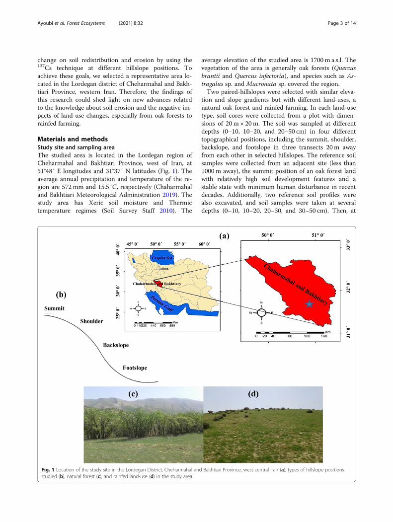
Materials and methodsStudy site and sampling areaThe studied area is located in the Lordegan region ofCheharmahal and Bakhtiari Province, west of Iran, at51°48′ E longitudes and 31°37′ N latitudes (Fig. 1). Theaverage annual precipitation and temperature of the re-gion are 572 mm and 15.5 °C, respectively (Chaharmahaland Bakhtiari Meteorological Administration 2019). Thestudy area has Xeric soil moisture and Thermictemperature regimes (Soil Survey Staff 2010). The
average elevation of the studied area is 1700 m a.s.l. Thevegetation of the area is generally oak forests (Quercusbrantii and Quercus infectoria), and species such as As-tragalus sp. and Mucronata sp. covered the region.Two paired-hillslopes were selected with similar eleva-
tion and slope gradients but with different land-uses, anatural oak forest and rainfed farming. In each land-usetype, soil cores were collected from a plot with dimen-sions of 20 m × 20m. The soil was sampled at differentdepths (0–10, 10–20, and 20–50 cm) in four differenttopographical positions, including the summit, shoulder,backslope, and footslope in three transects 20 m awayfrom each other in selected hillslopes. The reference soilsamples were collected from an adjacent site (less than1000 m away), the summit position of an oak forest landwith relatively high soil development features and astable state with minimum human disturbance in recentdecades. Additionally, two reference soil profiles werealso excavated, and soil samples were taken at severaldepths (0–10, 10–20, 20–30, and 30–50 cm). Then, at
Fig. 1 Location of the study site in the Lordegan District, Cheharmahal and Bakhtiari Province, west-central Iran (a), types of hillslope positionsstudied (b), natural forest (c), and rainfed land-use (d) in the study area
Ayoubi et al. Forest Ecosystems (2021) 8:32 Page 3 of 14

the reference location, the vertical distribution of 137Cswas determined.
Laboratory analysis and 137Cs measurementsBefore the laboratory analysis, the air-dried soil sampleswere crushed, homogenized, and passed through a 2-mm sieve. From June to July 2018, a total of 72 soil sam-ples (two land-use types × three replicates per sampleplots × three soil depth classes × four hillslope positions)were collected within the studied area. In 2018, at theIsfahan University of Iran, soil samples (500 g) wereplaced in Marinelli beakers and sealed for 137Cs analysis.The 137Cs activity (Bq·kg− 1) was measured from the netarea under the full-energy peak at 662 keV (ISO 11929-1, 2000) using gamma spectroscopy with a high-resolution germanium detector. The reference materialNo. IAEA-375 obtained from Analytical Quality ControlServices, International Atomic Energy Agency, was usedfor quality control. The count time was approximately80,000 s, and the counting error was kept at < 10% andat the 95% confidence level. The 137Cs activities(Bq·kg− 1) were converted to area activities (Bq·m− 2)(Walling et al. 2002).The core method (Blake and Hartge 1986) and wet
combustion method (Nelson and Sommers 1996) wereused to determine soil bulk density and soil organic mat-ter (SOM) concentration, respectively. The Kjeldahl di-gestion method was used to determine the total nitrogen(TN) (Bremmer and Mulvaney 1982). Electrical conduct-ivity (EC) was determined in the extract using a con-ductivity meter (Rhoades 1982). Extractable potassium(Kava) was measured using 1mol·L− 1 ammonium acetateas the extractant (Richards 1954). The pipette method(Gee and Bauder 1986) was applied to measure soil par-ticle size distributions. Bernard’s calcimeter method wasused to measure calcium carbonate equivalent (CCE)content (Black et al. 1965). By using a Bartington MS2dual-frequency sensor at low frequency (χlf) (0.47 kHz),high frequency (χhf) (4.7 kHz), dependent frequency (χfd),and the magnetic susceptibility (MS) were measured in afour-dram clear plastic vial (2.3 cm diameter) using ap-proximately 10 g of soil.
Soil redistribution calculationSeveral different techniques have been applied to convert137Cs measurements to quantitative estimates of soil ero-sion and deposition rates (Walling and He 1999; Wallingand He 2000). By using the Simplified Mass BalanceModel (SMBM), we decide to use the conversion of137Cs areal activities into soil redistribution rates (t·ha− 1·yr− 1) (Walling and He 1999; Walling et al. 2002; Zhanget al. 2008).
Statistical analysesDescriptive and correlations among the variables weredetermined. The mean values of the 137Cs, soil physico-chemical properties, magnetic measures of two land-uses, and four hillslope positions were calculated. Allstatistical analyses, including the LSD test (test of signifi-cance of differences among the mean values) and correl-ation analyses, were performed using SPSS 17.0 (IBM,USA) software. Dexter et al. (2008) proposed severalequations (Eqs. 1–4) to calculate complexed and non-complexed organic carbon (OC) and clay. Then, theadditional amount of complexed OC, which could bestored in the soil, was estimated using Eq. 5:
CC ¼ nOCð Þ if nOC < clayð Þ; else CC ¼ clay ð1ÞNCC ¼ clay−CCð Þ if clay−CCð Þ > 0; else NCC
¼ 0 ð2ÞCOC ¼ OC if OC < clay=nð Þ; else COC
¼ clay=nð Þ ð3ÞNCOC ¼ OC−COC if OC−COCð Þ
> 0; else NCOC ¼ 0 ð4ÞPAOC ¼ CMAX−COCð Þ if CMAX−COCð Þ
> 0; else PAOC ¼ 0 ð5Þwhere CC and NCC are complexed and non-
complexed clays (g·kg− 1), COC and NCOC representcomplexed and non-complexed organic carbons (g·kg− 1),respectively, and n means the ratio of clay to OC, whereclay is assumed to be saturated with OC, which is con-sidered equal to 10 (Dexter et al. 2008). Therefore, satur-ation line was defined by COC = Clay/n (i.e., n = 10).PAOC (g·kg− 1) is the potential additional complexedOC which indicates the potential capacity for sequester-ing carbon, and CMAX (g·kg− 1) is the maximum pos-sible amount of complexed OC according to clay/n (n =10) (Dexter et al. 2008).
Results and discussionSpecific results per land-use and hillslope positionTable 1 presents the descriptive statistics of 137Cs mea-surements, physicochemical parameters, and soil mag-netic parameters in the studied two land-uses. In thenatural forest and the rainfed farming, the coefficient ofvariation (CV) of the 137Cs contents was 35.7% and30.8%, respectively. Abbaszadeh et al. (2010) and Ayoubiet al. (2012a) reported a CV value of 50.0% and 103.9%for the 137Cs inventory under rainfed farming and thehilly regions in western Iran, respectively. Consistentwith Wilding (1985) for CV classification, 137Cs, TN,and clay in the natural oak forest and SOM, Pava, andclay in the rainfed farming land-uses were classified as
Ayoubi et al. Forest Ecosystems (2021) 8:32 Page 4 of 14
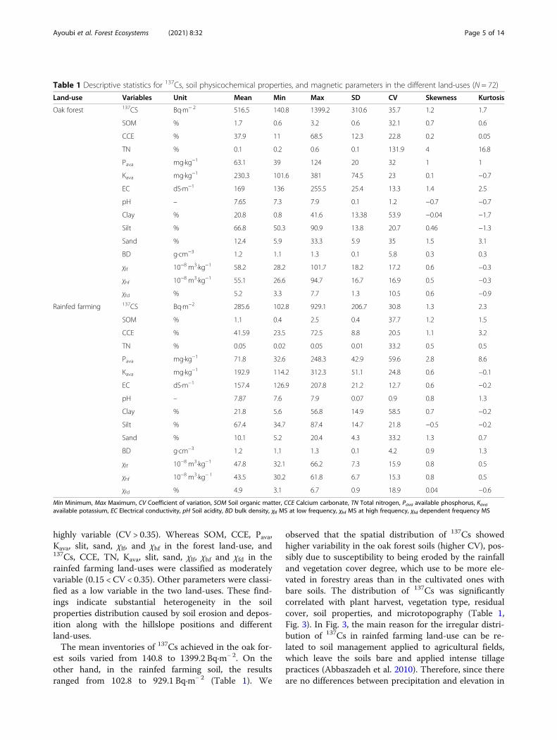
highly variable (CV > 0.35). Whereas SOM, CCE, Pava,Kava, slit, sand, χlf, and χhf in the forest land-use, and137Cs, CCE, TN, Kava, slit, sand, χlf, χhf and χfd in therainfed farming land-uses were classified as moderatelyvariable (0.15 < CV < 0.35). Other parameters were classi-fied as a low variable in the two land-uses. These find-ings indicate substantial heterogeneity in the soilproperties distribution caused by soil erosion and depos-ition along with the hillslope positions and differentland-uses.The mean inventories of 137Cs achieved in the oak for-
est soils varied from 140.8 to 1399.2 Bq·m− 2. On theother hand, in the rainfed farming soil, the resultsranged from 102.8 to 929.1 Bq·m− 2 (Table 1). We
observed that the spatial distribution of 137Cs showedhigher variability in the oak forest soils (higher CV), pos-sibly due to susceptibility to being eroded by the rainfalland vegetation cover degree, which use to be more ele-vated in forestry areas than in the cultivated ones withbare soils. The distribution of 137Cs was significantlycorrelated with plant harvest, vegetation type, residualcover, soil properties, and microtopography (Table 1,Fig. 3). In Fig. 3, the main reason for the irregular distri-bution of 137Cs in rainfed farming land-use can be re-lated to soil management applied to agricultural fields,which leave the soils bare and applied intense tillagepractices (Abbaszadeh et al. 2010). Therefore, since thereare no differences between precipitation and elevation in
Table 1 Descriptive statistics for 137Cs, soil physicochemical properties, and magnetic parameters in the different land-uses (N = 72)
Land-use Variables Unit Mean Min Max SD CV Skewness Kurtosis
Oak forest 137CS Bq·m− 2 516.5 140.8 1399.2 310.6 35.7 1.2 1.7
SOM % 1.7 0.6 3.2 0.6 32.1 0.7 0.6
CCE % 37.9 11 68.5 12.3 22.8 0.2 0.05
TN % 0.1 0.2 0.6 0.1 131.9 4 16.8
Pava mg·kg−1 63.1 39 124 20 32 1 1
Kava mg·kg−1 230.3 101.6 381 74.5 23 0.1 −0.7
EC dS·m−1 169 136 255.5 25.4 13.3 1.4 2.5
pH – 7.65 7.3 7.9 0.1 1.2 −0.7 −0.7
Clay % 20.8 0.8 41.6 13.38 53.9 −0.04 −1.7
Silt % 66.8 50.3 90.9 13.8 20.7 0.46 −1.3
Sand % 12.4 5.9 33.3 5.9 35 1.5 3.1
BD g·cm−3 1.2 1.1 1.3 0.1 5.8 0.3 0.3
χlf 10−8 m3·kg−1 58.2 28.2 101.7 18.2 17.2 0.6 −0.3
χhf 10−8 m3·kg−1 55.1 26.6 94.7 16.7 16.9 0.5 −0.3
χfd % 5.2 3.3 7.7 1.3 10.5 0.6 −0.9
Rainfed farming 137CS Bq·m−2 285.6 102.8 929.1 206.7 30.8 1.3 2.3
SOM % 1.1 0.4 2.5 0.4 37.7 1.2 1.5
CCE % 41.59 23.5 72.5 8.8 20.5 1.1 3.2
TN % 0.05 0.02 0.05 0.01 33.2 0.5 0.5
Pava mg·kg−1 71.8 32.6 248.3 42.9 59.6 2.8 8.6
Kava mg·kg−1 192.9 114.2 312.3 51.1 24.8 0.6 −0.1
EC dS·m−1 157.4 126.9 207.8 21.2 12.7 0.6 −0.2
pH – 7.87 7.6 7.9 0.07 0.9 0.8 1.3
Clay % 21.8 5.6 56.8 14.9 58.5 0.7 −0.2
Silt % 67.4 34.7 87.4 14.7 21.8 −0.5 −0.2
Sand % 10.1 5.2 20.4 4.3 33.2 1.3 0.7
BD g·cm−3 1.2 1.1 1.3 0.1 4.2 0.9 1.3
χlf 10−8 m3·kg−1 47.8 32.1 66.2 7.3 15.9 0.8 0.5
χhf 10−8 m3·kg− 1 43.5 30.2 61.8 6.7 15.3 0.8 0.5
χfd % 4.9 3.1 6.7 0.9 18.9 0.04 −0.6
Min Minimum, Max Maximum, CV Coefficient of variation, SOM Soil organic matter, CCE Calcium carbonate, TN Total nitrogen, Pava available phosphorus, Kavaavailable potassium, EC Electrical conductivity, pH Soil acidity, BD bulk density, χlf MS at low frequency, χhf MS at high frequency, χfd dependent frequency MS
Ayoubi et al. Forest Ecosystems (2021) 8:32 Page 5 of 14

the studied sites, it can be concluded that the main rea-son for 137Cs variation and its redistribution could bethe agricultural practices when the rainfed farming soilsare compared to the oak forest soils.In rainfed farming, the lowest and highest CV values
for the soil chemical properties were attributed to pH(0.07%) and Pava (59.6%), respectively. On the otherhand, in the natural forest, the lowest and highest CVvalues for the soil chemical properties were ascribed topH (0.1%) and TN (131.9%), respectively. In general, thehigh variance for the chosen soil properties in the hillyarea of the studied site suggested a possible redistribu-tion of the soil during the long-term cultivation of therainfed land and natural soil detachment and depositionat different locations of the hillslope (Jones et al. 2008).This agrees with other agricultural lands such as steepvineyards where tillage and the use of herbicides leavingthe soil bare can change soil erosion rates and, subse-quently, soil properties among hillslope positions(Rodrigo-Comino et al. 2016; Rodrigo-Comino et al.2017). However, when the inclination factor is reducedto the minimum, other authors used rainfall simulatorsalso in vineyards, which could not confirm this premise:differences among hillslope positions (Rodrigo-Cominoet al. 2018; Cerdà et al. 2020).
Relationships between 137Cs, MS, and soil propertiesThe relationships between selected soil properties and137Cs inventory in different land-uses are shown inTable 2. The 137Cs inventory showed consistent signifi-cant correlation coefficients with Kava, CCE, χlf, χhf, andclay in oak forest soils and significant correlation
coefficients with Pava, CCE, χhf, sand, and clay in rainfedfarming soils. Moreover, in the oak forest, significantpositive correlation coefficients between 137Cs and Kava
(r = 0.69, p < 0.01), 137Cs and CCE (r = 0.57, p < 0.01),and 137Cs and χlf (r = 0.78, p < 0.01), and 137Cs and χhf(r = 0.78, p < 0.01) were observed (Table 2). The negativesignificant correlation coefficient between 137Cs and claycontent (r = − 0.40, p < 0.05) was achieved (Table 2) forthe oak forest. The 137Cs inventory showed consistentsignificant correlation coefficients with CCE (r = 0.38,p < 0.05), Pava (r = 0.35, p < 0.05), χhf (r = 0.33, p < 0.05),clay (r = 0.37, p < 0.05) and sand (r = − 0.35, p < 0.05), inrainfed farming land-uses. The highest correlation coeffi-cient for 137Cs was observed with χlf and χhf in oak forestland-uses. These 137Cs correlations with soil physico-chemical properties indicated that soil erosion and de-position processes could partially regulate the 137Csvariability within the study sites for the selected soilproperties (de Neergaard et al. 2008; Olson et al. 2013).In other words, certain soil properties such as soil nutri-ents, SOM, and magnetic minerals, and 137Cs inventorywere related to detachment and accumulation of fineparticles are regulated simultaneously along the hillslope(Fu et al. 2009; Wakiyama et al. 2010; Li et al. 2017).This outcome revealed that the effects of natural factorson soil erosion rates and other factors, such as the roleof land-use types and human activity, could affect thelocal soil erosion.
137Cs inventory and soil redistribution assessmentThe characteristic of reference sampling locations, in-cluding 137Cs depth profiles and their inventories, aregiven in Fig. 2. In the topsoil layer (0–10 cm), a signifi-cant volume of activity of 137Cs was concentrated anddecreased with depth. The mean value of 137Cs inven-tory obtained from the two reference sites was 978Bq·m− 2, which is consistent with another study fromwestern Iran with 2120 Bq·m− 2 (Abbaszadeh Afsharet al. 2010), 2067 Bq·m− 2 (Rahimi et al. 2013), and 878Bq·m− 2 (Bazshoshtari et al. 2016) inventory of soils.The vertical distribution of 137Cs values in the rainfed
farming and natural forest sites for four different hill-slopes positions was showed in Fig. 3. A significantamount of 137Cs activity was concentrated in the topsoillayer (0–10 cm) in oak forest land-use (Fig. 3), and theprofile on the summit and shoulder positions showed anear-exponential decline in 137Cs activity with a depththat indicated undisturbed soils in nature forest land-use(Fig. 3a and b). Several studies also reported a high con-centration of 137Cs activity in the upper soil layers thanthe lower ones (Abbaszadeh Afshar et al. 2010; Ayoubiet al. 2012a; Rahimi Ashjerdi et al. 2013; Bazshoushtariet al. 2016).
Table 2 Correlation coefficients among 137Cs inventory andselected soil properties in the study area
Variable Oak forest Rainfed farming
Cs-137 Cs-137
SOM 0.301 0.020
Kava 0.687b −0.130
EC 0.135 0.122
pH 0.279 −0.082
CCE 0.572b 0.382a
TN 0.083 −0.207
BD 0.239 −0.329
Pava −0.055 0.345a
χlf 0.780b −0.325
χhf 0.776b 0.334a
Sand 0.275 −0.345a
Clay −0.399a 0.374a
SOM Soil organic matter, CCE Calcium carbonate, TN Total nitrogen, Pavaavailable phosphorus, Kava available potassium, EC Electrical conductivity, pHSoil acidity, BD bulk density, χlf MS at low frequency, χhf MS at high frequencya and b stand for significance at probability levels of 0.05 and 0.01, respectively
Ayoubi et al. Forest Ecosystems (2021) 8:32 Page 6 of 14

As demonstrated in Fig. 3, the 137Cs values in the nat-ural forest soils are significantly different between 0 and10, 10–20, and 20–50 cm depths, but in the rainfedfarming are significantly different between 0 and 10 and10–20 cm depths in the summit positions (Fig. 3a ande). The natural forest soils showed considerably greatervalues of the 137Cs than rainfed farming soils at threedepths in summit position (Fig. 3a and e). The distribu-tion of 137Cs activity through the surface horizons wasinfluenced by both plowing and soil erosion. There wasa significant difference in 137Cs activity distribution fol-lowing the land-use change to rainfed farming in theupper 20 cm of the soil with subsoil in shoulder posi-tions (Fig. 3f). The 137Cs activity was showed a signifi-cant difference (p < 0.05) between 20 and 50 and 10–20cm depths in backslope and footslope positions in bothland-uses (Fig. 3c and g). These findings indicate thatthe conversion of the natural forest land into rainfedfarming significantly reduced 137Cs values in each hill-slope position.The soil erosion estimation rate by SMBM was (9.3
t·ha− 1·yr− 1) for the natural forest, while the higher soilloss (51.1 t·ha− 1·yr− 1) was calculated in rainfed farming.The sloping rainfed farming erosion rate is more thandouble that of the natural forest, suggesting that signifi-cant soil loss occurred during the agriculture practicesafter forest conversion (Fig. 4). By using SMBM in theArdal district, west of Iran, Abbaszadeh et al. (2010)showed that soil erosion rates varied between 4.8 to183.9 t·ha− 1·yr− 1 in rainfed farming.The soil erosion and deposition rates were presented
in Fig. 4 in oak forest and rainfed farming sites for fourdifferent hillslope positions. The highest soil erosion ratewith a mean value of 162.3 t·ha− 1·yr− 1 occurred in the
summit component of rainfed farming land-use. Previ-ous studies showed that inclination is one of the mostinfluential factors that could enhance soil loss in thehighest hillslope position (i.e., summit position) (Brad-ford and Foster, 1966; Aksoy and Kavvas 2005; Assoulineet al. 2006). The soil deposition occurred mainly in theback- and foot-slope positions in the natural forest areawith mean values of 148.3 and 376 t·ha− 1·yr− 1, respect-ively. This shows that eroded material from summit andshoulder positions are mobilized in the two lowest hill-slope positions. In the rainfed farming areas, the highestsoil erosion occurred on summit and shoulder positionswith mean values of 162.3 and 99.3 t·ha− 1·yr− 1, respect-ively. Unlike the oak forest areas, soil erosion occurredon the backslope of the rainfed farming areas. In rainfedfarming, the highest soil deposition rate occurred in thefootslope position with a mean value of 140.95 t·ha− 1·yr− 1. The sediments carried from the upslope parts de-posited in the lower position (e.g., footslope position)(Fig. 4). Several studies obtained similar results (Sacet al. 2008; Abbaszadeh et al. 2010; Ayoubi et al. 2012b)confirmed the deposition rate in the downslopes (i.e.,back- and foot-slope) was the highest.The soil erosion rate in rainfed soils was greater than
that of natural forest soils (Fig. 4). On the summit pos-ition, for instance, the soil erosion rate in all threerainfed farming land-use samples was 162.3 t·ha− 1·yr− 1,but in the oak forest was only 7.2 t·ha− 1·yr− 1. The soilerosion rate on the shoulder position of rainfed farmingland-use (99.3 t·ha− 1·yr− 1) was much higher than naturalforest land-use (32.4 t·ha− 1·yr− 1) (Fig. 4). The soil lossesin the summit and shoulder positions obtained by theSMBM showed significant differences (p < 0.05) for theoak forest and the rainfed farming. Also, there was a
Fig. 2 Depth distribution profiles for 137Cs inventory (Bq·m−2) in the reference sampling sites
Ayoubi et al. Forest Ecosystems (2021) 8:32 Page 7 of 14

Fig. 3 Depth distribution profiles for 137Cs inventory (Bq·m−2) in forest land-use (a), summit (b), shoulder (c), backslope (d) footslope and rainfedland-use (e), summit (f),shoulder (g), backslope (h) footslope. Different letters on the bars show the statistical difference at p < 0.05
Ayoubi et al. Forest Ecosystems (2021) 8:32 Page 8 of 14

significant difference (p < 0.05) between the two land-uses for the backslope and footslope positions accordingto soil deposition (Fig. 4). Higher soil redistribution ondifferent hillslope positions of rainfed farming landscompared with forest land-use confirmed changing land-use (e.g., human activity), which remarkably enhancessoil erosion in the study area. Moreover, the tillage prac-tices and loss of vegetation cover in the steep slopes ofthe cultivated areas were considered as the major factorsaffecting soil properties in the studied area. Therefore,removing vegetation cover or tillage practices could in-crease the probability of large erosion events. Sheet andrill erosion are the dominant erosion processes withinthe rainfed cultivation catchment. These findings are inline with the findings of Mokhtari Karchegani et al.(2011) and Ayoubi et al. (2012a). Although rainfed farm-ing vegetation could help to sustain the soil, but thevegetation cover would be less dense and stable thanafter deforestation. Additionally, the tree roots improvedsoil water retention and reduced the direct effect of rain-fall splash (Wittenberg et al. 2020).
Soil property variations in slope positions and land-usesIn the oak forest soil, the mean MS at high frequency(χhf) was significantly (p < 0.05) higher than in therainfed agricultural soil (Fig. 5a). The undisturbed soilwith a lower soil loss in the summit and shoulder posi-tions of hillslope (Fig. 4) indicated higher χhf rather than
in the disturbed soils (Fig. 5). On the other hand, due tosoil deposition in the backslope and footslope positions,χhf showed higher value than other positions. Further-more, in the downslope positions, especially in the nat-ural forest land, the pedogenic process was more intensebecause of the water received from the upslope in theform of surface and sub-surface flows, which can causethe leaching of carbonates and enhanced χhf (Singeret al. 1996; Ayoubi et al. 2012a; Rahimi et al. 2013).There was no significant difference in χhf in rainfedfarming soils, which could be related to soil tillage dis-turbance (Fig. 5a). These findings agree with Liu et al.(2018), who stated a significant positive correlation be-tween soil erosion and magnetic properties. The locationof the hillslope position influences the variability of soilattributes, especially magnetic properties. There is evi-dence within the hillslope for soil movement as soil ero-sion occurs in the shoulder and backslope and soildeposition in downslope positions.SOM in the natural oak forest soil was significantly
(p < 0.05) higher than in the rainfed farming soil. Thelowest SOM was observed in both land-uses in theshoulder position, which was associated with the highestslope and soil loss rate. In addition, SOM was signifi-cantly (p < 0.05) in both land-uses in different hillslopepositions (Fig. 5b). On the other hand, Ayoubi et al.(2012a) and Nosrati et al. (2015) obtained the low SOMin shoulder positions of hillslope in the Chelgerd Nachi
Fig. 4 The soil erosion rates and deposition in natural forest and rainfed farming per hillslope positions (summit, shoulder, backslope, andfootslope). Different letters on the bars show the statistical difference at p < 0.05
Ayoubi et al. Forest Ecosystems (2021) 8:32 Page 9 of 14
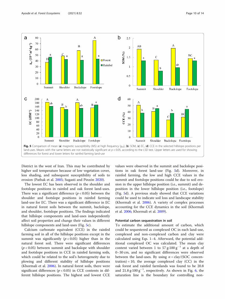
District in the west of Iran. This may be contributed byhigher soil temperature because of low vegetation cover,less shading, and subsequent susceptibility of soils toerosion (Pathak et al. 2005; Sugasti and Pinzón 2020).The lowest EC has been observed in the shoulder and
footslope positions in rainfed and oak forest land-uses.There was a significant difference (p < 0.05) between theshoulder and footslope positions in rainfed farmingland-use for EC. There was a significant difference in ECin natural forest soils between the summit, backslope,and shoulder, footslope positions. The findings indicatedthat hillslope components and land-uses independentlyaffect soil properties and change their values in differenthillslope components and land-uses (Fig. 5c).Calcium carbonate equivalent (CCE) in the rainfed
farming soil in all of the hillslope positions except in thesummit was significantly (p < 0.05) higher than in thenatural forest soil. There were significant differences(p < 0.05) between summit and backslope with shoulderand footslope positions in CCE in rainfed farming soils,which could be related to the soil’s heterogeneity due toplowing and different stability of hillslope positions(Khormali et al. 2006). In natural forest soils, there weresignificant differences (p < 0.05) in CCE contents in dif-ferent hillslope positions. The highest and lowest CCE
values were observed in the summit and backslope posi-tions in oak forest land-use (Fig. 5d). Moreover, inrainfed farming, the low and high CCE values in thesummit and footslope positions could be due to soil ero-sion in the upper hillslope position (i.e., summit) and de-position in the lower hillslope position (i.e., footslope)(Fig. 5d). A previous study showed that CCE variationscould be used to indicate soil loss and landscape stability(Khormali et al. 2006). A variety of complex processesaccounting for the CCE dynamics in the soil (Khormaliet al. 2006; Khormali et al. 2009).
Potential carbon sequestration in soilTo estimate the additional amount of carbon, whichcould be sequestered as complexed OC in each land-use,complexed and non-complexed carbon and clay werecalculated using Eqs. 1–4. Afterward, the potential add-itional complexed OC was calculated. The mean claycontent varied between 1 to 57 g·100 g− 1 at a depth of0–30 cm, and no significant differences were observedbetween the land-uses. By using n = clay/(SOC concen-tration) = 10, the average complexed clay (CC) in theoak forest and rainfed farmlands was found to be 20.8and 21.8 g·100 g− 1, respectively. As shown in Fig. 6, thesaturation line is the boundary for controlling non-
Fig. 5 Comparison of mean (a) magnetic susceptibility (MS) at high frequency (χhf), (b) SOM, (c) EC, (d) CCE in the selected hillslope positions perland-uses. Means with the same letters are not statistically significant at p < 0.05, according to the LSD test. Upper letters are used for showingdifferences for forest and lower letters for rainfed farming land-use
Ayoubi et al. Forest Ecosystems (2021) 8:32 Page 10 of 14

complexed organic carbon (NCOC) and non-complexedclay (NCC). More the soils were located under the satur-ation line (Fig. 6), the amount of complexed clay (CC)corresponded to the complexed organic carbon (COC)(whole amount of SOC concentration), and the non-complexed organic carbon (NCOC) was equal to 0. Thetexture of the oak forest soil is closer to the saturationline. In the natural forest, soil behavior is affected bynon-complexed carbon. However, in rainfed farming,due to the heavy texture of the soil, the composition ofthe soil is affected by non-complexed clay. This indicatesthat the textures of the two land-uses are not the same.Alidoust et al. (2018) assess and compare improvementsand capacity of SOC sequestration under various land-uses in western central Iran. The findings revealed thatall soils analyzed consisted of non-complexed clay,showing a significant carbon sequestration capacity.Moreover, the findings have shown that the SOC con-trolling variables differed considerably between land-uses and soil depths. Reduction of inputs biomass, accel-eration of soil erosion, and the increase of SOM turn-over rate are the key factors for the SOC concentrationreduction due to the conversion of forest to agriculturallands (Albaladejo et al. 2013). Some studies have alsoshown that the depletion of SOC land-use conversion toagricultural lands in the semi-arid areas could be higherthan in humid areas (Martinez-Mena et al. 2008).
ConclusionsSoil redistribution rate demonstrates remarkably highererosion in rainfed farming than natural forest (oak for-est) soils. The results of using 137Cs radionuclide mea-surements indicated severe erosion in the summit
(162.3 t·ha− 1·yr− 1) and shoulder (99.3 t·ha− 1·yr− 1) hill-slope positions of rainfed farming soil after changes fromoak forests. This confirms that land-use changes fromthe undisturbed ecosystem (i.e., natural forest) to dis-turbed ecosystems (i.e., dryland farming) significantly in-crease soil erosion. The shoulder and summit positionswere the most erodible hillslope positions in the naturalforest and rainfed farming, respectively. These resultshighlight the critical role of hillslope position and land-use changes in eroding the surface soils in hilly naturaland anthropogenic areas. In addition, the results illus-trated that land management has a powerful influenceon soil erosion intensity and may both mitigate andamplify soil loss. Our findings present evidence that thecombined influence of soil redistribution and land-usechange applies a significant control over the spatial dis-tribution of soil properties. Therefore, the data obtainedachieves a better understanding of the effect of land-usechange and land management in the Zagros region.
Abbreviations137Cs: Caesium-137; MS: Magnetic susceptibility; χhf: MS at high frequency;χlf: MS at low frequency; χfd: Dependent frequency MS; SOM: Soil organicmatter; TN: Total nitrogen; EC: Electrical conductivity; Kava: Extractablepotassium; Pava: Extractable phosphorous; CCE: Calcium carbonate equivalent;SMBM: Simplified Mass Balance Model; OC: Organic carbon; CC: Complexedclays; NCC: Non-complexed clays; COC: Complexed organic carbons;NCOC: Non-complexed organic carbons; PAOC: Potential additionalcomplexed organic carbon; CMAX: Maximum possible amount of complexedOC; CV: Coefficient of variation; Min: Minimum; Max: Maximum; pH: Soilacidity; BD: Bulk density
AcknowledgmentsThe authors thank the Isfahan University of Technology for providing theexperimental facilities. Mojtaba Zeraatpisheh’s postdoctoral program atHenan University, China, has been supported by the National Key Research
Fig. 6 Application of Dexter’s clay to carbon saturation concept per land-uses. The line corresponds to the saturation trend (1:10)
Ayoubi et al. Forest Ecosystems (2021) 8:32 Page 11 of 14

and Development Program of China, grant numbers 2017YFA0604302 and2018YFA0606500.
Authors’ contributionsSA: Conceptualization, Methodology, Software, Validation, Writing - originaldraft, Writing - review & editing, Visualization, Supervision; NS: Methodology,Software, Validation, Writing - original draft, Writing - review & editing,Visualization; FAA: Writing - original draft and Writing - review & editing;MRA: Methodology and Writing - review & editing; MZ: Writing - originaldraft, Writing - review & editing, Supervision, and Visualization; JR: Writing -review & editing. The authors read and approved the final manuscript.
FundingThere is no external funding for this work.
Declarations
Ethics approval and consent to participateNot applicable.
Consent for publicationNot applicable.
Competing interestsThe authors declare they have no competing interests.
Author details1Department of Soil Science, College of Agriculture, Isfahan University ofTechnology, Isfahan 84156-83111, Iran. 2Department of Soil Science, Collegeof Agriculture, University of Jiroft, Kerman, Iran. 3Department of Physics,Faculty of Science, University of Isfahan, Isfahan 81747-73441, Iran. 4HenanKey Laboratory of Earth System Observation and Modeling, Henan University,Kaifeng 475004, China. 5College of Environment and Planning, HenanUniversity, Kaifeng 475004, China. 6Department of Physical Geography,University of Trier, Trier, Germany. 7Soil Erosion and Degradation ResearchGroup, Department of Geography, Universitat de València, Valencia, Spain.
Received: 11 January 2021 Accepted: 10 May 2021
ReferencesAbbaszadeh F, Ayoubi S, Jalalian A (2010) Soil redistribution rate and its
relationship with soil organic carbon and total nitrogen using 137Cstechnique in a cultivated complex hillslope in western Iran. J EnvironRadioact 101(8):606–614
Ajami M, Heidari A, Khormali F, Zeraatpisheh M, Gorji M, Ayoubi S (2020) Spatialvariability of rainfed wheat production under the influence of topographyand soil properties in loess-derived soils, northern Iran. Int J Plant Prod 14(4):597–608. https://doi.org/10.1007/s42106-020-00106-4
Aksoy H, Kavvas ML (2005) A review of hillslope and watershed scale erosion andsediment transport models. Catena 64(2-3):247–271. https://doi.org/10.1016/j.catena.2005.08.008
Akter T, Quevauviller P, Eisenreich SJ, Vaes G (2018) Impacts of climate and landuse changes on flood risk management for the Schijn River, Belgium. EnvironSci Pol 89:163–175. https://doi.org/10.1016/j.envsci.2018.07.002
Al Sayah MJ, Abdallah C, Khouri M, Nedjai R, Darwich T (2019) Application of theLDN concept for quantification of the impact of land use and land coverchanges on Mediterranean watersheds - Al Awali basin - Lebanon as a casestudy. Catena 176:264–278. https://doi.org/10.1016/j.catena.2019.01.023
Albaladejo J, Ortiz R, Garcia-Franco N, Navarro AR, Almagro M, Pintado JG,Martínez-Mena M (2013) Land use and climate change impacts on soilorganic carbon stocks in semi-arid Spain. J Soils Sediments 13(2):265–277.https://doi.org/10.1007/s11368-012-0617-7
Alidoust E, Afyuni M, Hajabbasi MA, Mosaddeghi MR (2018) Soil carbonsequestration potential as affected by soil physical and climatic factors underdifferent land uses in a semi-arid region. Catena 171:62–71. https://doi.org/10.1016/j.catena.2018.07.005
Assouline S, Ben-Hur M (2006) Effects of rainfall intensity and slope gradient onthe dynamics of interrill erosion during soil surface sealing. Catena 66(3):211–220. https://doi.org/10.1016/j.catena.2006.02.005
Ayoubi S, Ahmadi M, Abdi MR, Abbaszadeh Afshar F (2012a) Relationships of137Cs inventory with magnetic measures of calcareous soils of hilly region inIran. J Environ Radioact 112:45–51. https://doi.org/10.1016/j.jenvrad.2012.03.012
Ayoubi S, Mokhtari J, Mosaddeghi MR, Zeraatpisheh M (2018) Erodibility ofcalcareous soils as influenced by land use and intrinsic soil properties in asemi-arid region of Central Iran. Environ Monit Assess 190(4):192. https://doi.org/10.1007/s10661-018-6557-y
Ayoubi S, Mokhtari Karchegani P, Mosaddeghi MR, Honarjoo N (2012b) Soilaggregation and organic carbon as affected by topography and land usechange in western Iran. Soil Till Res 121:18–26. https://doi.org/10.1016/j.still.2012.01.011
Bajocco S, De Angelis A, Perini L, Ferrara A, Salvati L (2012) The impact of landuse/land cover changes on land degradation dynamics: a Mediterraneancase study. Environ Manag 49(5):980–989. https://doi.org/10.1007/s00267-012-9831-8
Bakhshandeh E, Hossieni M, Zeraatpisheh M, Francaviglia R (2019) Land usechange effects on soil quality and biological fertility: a case study in northernIran. Eur J Soil Biol 95:103119. https://doi.org/10.1016/j.ejsobi.2019.103119
Bazshoushtari N, Ayoubi S, Abdi MR (2016) Variability of 137Cs inventory at areference site in west-Central Iran. J Environ Radioact 165:86–92. https://doi.org/10.1016/j.jenvrad.2016.09.010
Black CA, Evans DD, White JL, Ensminger LE, Clark FE (1965) Methods of soilanalysis, part 2. Agronomy monograph no. 9. ASA and soil science Society ofAmerica, Madison
Blake GR, Hartge KH (1986) Bulk density. In: Klute A (ed) Methods of soil analysis.Part I: physical and mineralogical methods, second agronomy monographno 9. American Society of Agronomy, Madison, pp 363–375
Bradford JM, Foster GR (1966) Interril soil erosion and slope steepness factors. SoilSci Soc Am J 60:909–915
Bremmer JM, Mulvaney CS (1982) Total nitrogen. In: Page AL, Miller RH, KeeneyDR (eds) Methods of soil analysis, part 2: chemical and microbiologicalproperties, 2nd edn. Agronomy monograph no. 9. American Society ofAgronomy, Madison
Celik I (2005) Land-use effects on organic matter and physical properties of soilin a southern Mediterranean highland of Turkey. Soil Till Res 83(2):270–277.https://doi.org/10.1016/j.still.2004.08.001
Cerdà A, Rodrigo-Comino J (2020) Is the hillslope position relevant for runoff andsoil loss activation under high rainfall conditions in vineyards? EcohydrolHydrobiol 20(1):59–72. https://doi.org/10.1016/j.ecohyd.2019.05.006
Chaharmahal and Bakhtiari Meteorological Administration (2019) http://www.chbmet.ir/en/dataarchive.asp. Accessed 15 Jan 2021
Chauchard S, Carcaillet C, Guibal F (2007) Patterns of land-use abandonmentcontrol tree-recruitment and forest dynamics in Mediterranean mountains.Ecosystems 10(6):936–948. https://doi.org/10.1007/s10021-007-9065-4
Curtis PG, Slay CM, Harris NL, Tyukavina A, Hansen MC (2018) Classifying driversof global forest loss. Science 361(6407):1108–1111. https://doi.org/10.1126/science.aau3445
de Neergaard A, Magid J, Mertz O (2008) Soil erosion from shifting cultivationand other smallholder land use in Sarawak, Malaysia. Agric Ecosyst Environ125(1-4):182–190. https://doi.org/10.1016/j.agee.2007.12.013
Dexter AR, Richard G, Arrouays D, Czyz EA, Jolivet C, Duval O (2008) Complexedorganicmatter controlssoil physical properties. Geoderma 144(3-4):620–627.https://doi.org/10.1016/j.geoderma.2008.01.022
Ehrenberg R (2015) Global count reaches 3 trillion trees. Nature. https://doi.org/10.1038/nature.2015.18287
Elliott GL, Campbell BL, Loughran RJ (1990) Correlation of erosion measurementsand soil caesium-137 content. Appl Radiat Isotopes 41(8):713–717. https://doi.org/10.1016/0883-2889(90)90017-B
Foley JA, DeFries R, Asner GP, Barford C, Bonan G, Carpenter SR, Chapin FS, CoeMT, Daily GC, Gibbs HK, Helkowski JH, Holloway T, Howard EA, Kucharik CJ,Monfreda C, Patz JA, Prentice IC, Ramankutty N, Snyder PK (2005) Globalconsequences of land use. Science 309(5734):570–574. https://doi.org/10.1126/science.1111772
Forest (2018) Range and Watershed Management Organication (FRWO). https://www.frw.ir/02/en/staticpages/page.aspx?tid=13231. Accessed 15 Jan 2021
Fu B-J, Wang Y-F, Lu Y-H, He C-S, Chen L-D, Song C-J (2009) The effects of land-use combinations on soil erosion: a case study in the loess plateau of China.Prog Phys Geogr 33(6):793–804. https://doi.org/10.1177/030913330935026
Gee GW, Bauder JW (1986) Particle size analysis. In: Klute A (ed) Methods of soilanalysis, part 1. Am Soc Agron, Elsevier Science, Amsterdam, pp 383–411
Ayoubi et al. Forest Ecosystems (2021) 8:32 Page 12 of 14

Hill J, Stellmes M, Udelhoven T, Röder A, Sommer S (2008) Mediterraneandesertification and land degradation: mapping related land use changesyndromes based on satellite observations. Glob Planet Chang 64(3-4):146–157. https://doi.org/10.1016/j.gloplacha.2008.10.005
Houghton RA, House JI, Pongratz J, Van Der Werf GR, DeFries RS, Hansen MC,Quéré CL, Ramankutty N (2012) Carbon emissions from land use and land-cover change. Biogeosciences 9(12):5125–5142. https://doi.org/10.5194/bg-9-5125-2012
Hu Y, Zhang Y (2019) Using 137Cs and 210Pbex to investigate the soil erosion andaccumulation moduli on the southern margin of the Hunshandake Sandyland in Inner Mongolia. J Geogr Sci 29(10):1655–1669. https://doi.org/10.1007/s11442-019-1983-1
Jones RJA, Verheijen FGA, Reuter HI, Jones AR. (eds). Environmental Assessmentof Soil for Monitoring Volume V: Procedures & Protocols. EUR 23490 EN/5,Office for the Official Publications of the European Communities,Luxembourg; 2008. 165 pp.
Jordan G, Van Rompaey AJ, Szilassi P, Csillag G, Mannaerts C, Woldai T (2005)Historical land use changes and their impact on sediment fluxes in theBalaton basin (Hungary). Agric Ecosyst Environ 108(2):119–133. https://doi.org/10.1016/j.agee.2005.01.013
Kavian A, Sabet SH, Solaimani K, Jafari B (2017) Simulating the effects of land usechanges on soil erosion using RUSLE model. Geocarto Int 32(1):97–111.https://doi.org/10.1080/10106049.2015.1130083
Kelishadi H, Mosaddeghi MR, Hajabbasi MA, Ayoubi S (2014) Near-saturated soilhydraulic properties as influenced by land use management systems inKoohrang region of central Zagros, Iran. Geoderma 213:426–434. https://doi.org/10.1016/j.geoderma.2013.08.008
Khormali F, Abtahi A, Stoops G (2006) Micromorphology of calcitic features inhighly calcareous soils of Fars Province, southern Iran. Geoderma 132(1-2):31–46. https://doi.org/10.1016/j.geoderma.2005.04.024
Khormali F, Ajami M, Ayoubi S, Srinivasarao C, Wani S (2009) Role of deforestationand hillslope position on soil quality attributes of loess-derived soils inGolestan province, Iran. Agric Ecosyst Environ 134(3–4):178–189. https://doi.org/10.1016/j.agee.2009.06.017
Kosmas C, Moustakas N, Danalatos NG, Yassoglou N (1995) The effect of land usechange on soil properties and erosion along a catena. In: Thornes JB, BrandtCJ (eds) Mediterranean desertification and land use. Wiley, Chichester, pp207–227
Lal R (2015) Restoring soil quality to mitigate soil degradation. Sustainability 7(5):5875–5895. https://doi.org/10.3390/su7055875
Li X-G, Li F-M, Zed R, Zhan Z-Y (2007) Soil physical properties and theirrelations to organic carbon pools as affected by land use in an alpinepastureland. Geoderma 139(1-2):98–105. https://doi.org/10.1016/j.geoderma.2007.01.006
Li Z, Liu C, Dong Y, Chang X, Nie X, Liu L, Xiao H, Lu Y, Zeng G (2017) Responseof soil organic carbon and nitrogen stocks to soil erosion and land use typesin the loess hilly–gully region of China. Soil Till Res 166:1–9. https://doi.org/10.1016/j.still.2016.10.004
Liu D, Huang Y, An S, Sun H, Bhople P, Chen Z (2018) Soil physicochemical andmicrobial characteristics of contrasting land-use types along soil depthgradients. Catena 162:345–353. https://doi.org/10.1016/j.catena.2017.10.028
MacDonald D, Crabtree JR, Wiesinger G, Dax T, Stamou N, Fleury P, GutierrezLazpita J, Gibon A (2000) Agricultural abandonment in mountain areas ofEurope: environmental consequences and policy response. J Environ Manag59(1):47–69. https://doi.org/10.1006/jema.1999.0335
Martinez-Mena M, Lopez J, Almagro M, Boix-Fayos C, Albaladejo J (2008) Effect ofwater erosion and cultivation on the soil carbon stock in a semiarid area of south-East Spain. Soil Tillage Res 99(1):119–129. https://doi.org/10.1016/j.still.2008.01.009
Meliho M, Nouira A, Benmansour M, Boulmane M, Khattabi A, Mhammdi N,Benkdad A (2019) Assessment of soil erosion rates in a Mediterraneancultivated and uncultivated soils using fallout 137Cs. J Environ Radioact 208–209:106021
Mojiri A, Aziz HA, Ramaji A (2012) Potential decline in soil quality attributes as aresult of land use change in a hillslope in Lordegan, western Iran. Afr J AgrRes 7(4):577–582. https://doi.org/10.5897/AJAR11.1505
Mokhtari Karchegani P, Ayoubi S, Lu S, Honarju N (2011) Use of magneticmeasures to assess soil redistribution following deforestation in hilly region. JAppl Geophys 75(2):227–236. https://doi.org/10.1016/j.jappgeo.2011.07.017
Nabiollahi K, Heshmat E, Mosavi A, Kerry R, Zeraatpisheh M, Taghizadeh-MehrjardiR (2020) Assessing the influence of soil quality on rainfed wheat yield.Agriculture 10(10):469. https://doi.org/10.3390/agriculture10100469
Naghipour AA, Bashari H, Khajeddin SJ, Tahmasebi P, Iravani M (2016) Effects ofsmoke, ash and heat shock on seed germination of seven species fromcentral Zagros rangelands in the semi-arid region of Iran. Afr J Range ForestSci 33(1):67–71. https://doi.org/10.2989/10220119.2015.1119194
Nelson DW, Sommers LE (1996) Total carbon, organic carbon, and organicmatter. In: Bartels JM, Bigham JM (eds) Methods of soil analysis: part 3chemical methods. American Society of Agronomy, Madison, pp 961–1010
Nosrati K, Haddadchi A, Zare MR, Shirzadi L (2015) An evaluation of the role ofhillslope components and land use in soil erosion using 137Cs inventory andsoil organic carbon stock. Geoderma 243–244:29–40
Novara A, Cerdà A, Dazzi C, Lo Papa G, Santoro A, Gristina L (2015) Effectivenessof carbon isotopic signature for estimating soil erosion and deposition ratesin Sicilian vineyards. Soil Till Res 152:1–7. https://doi.org/10.1016/j.still.2015.03.010
Olson KR, Gennadiyev AN, Zhidkin AP, Markelov MV, Golosov VN, Lang JM (2013)Use of magnetic tracer and radio-cesium methods to determine pastcropland soil erosion amounts and rates. Catena 104:103–110. https://doi.org/10.1016/j.catena.2012.10.015
Orgiazzi A, Ballabio C, Panagos P, Jones A, Fernándezes-Ugalde O (2018) LUCASsoil, the largest expandable soil dataset for Europe: a review. Eur J Soil Sci69(1):140–153. https://doi.org/10.1111/ejss.12499
Pathak P, Sahrawat KL, Rego TJ, Wani SP (2005) Measurable biophysical indicatorsfor impact assessment: changes in soil quality. In: Shiferaw B, Freeman HA,Swinton SM (eds) Natural resource management in agriculture: methods forassessing economical and environmental impacts. ICRISAT, Patancheru.https://doi.org/10.1079/9780851998282.0053
Quesada B, Arneth A, Robertson E, de Noblet-Ducoudré N (2018) Potential strongcontribution of future anthropogenic land-use and land-cover change to theterrestrial carbon cycle. Environ Res Lett 13(6):064023. https://doi.org/10.1088/1748-9326/aac4c3
Rahimi MR, Ayoubi S, Abdi MR (2013) Magnetic susceptibility and Cs-137inventory variability as influenced by land use change and slope positions ina hilly semi-arid region of west-Central Iran. J Appl Geophys 89:68–75.https://doi.org/10.1016/j.jappgeo.2012.11.009
Rhoades JD (1982) Soluble salts. In: Page AL. Methods of soil analysis, part 3, 2nd edn.Agronomy monograph, no. 9. American Society of Agronomy, Madison, 167
Richards LA (1954) Diagnosis and improvement of saline and alkaline soil. USDAhand book Office, Washington DC
Ritchie JC, Ritchie CA (2007) Bibliography of publications of 137-cesium studiesrelated to erosion and sediment deposition. http://www.ars.usda.gov/Main/docs.htm?docid¼15237. Accessed 15 Jan 2021
Rodrigo-Comino J, Keesstra S, Cerdà A (2018) Soil erosion as an environmentalconcern in vineyards: the case study of Celler del Roure, eastern Spain, bymeans of rainfall simulation experiments. Beverages 4(2):31. https://doi.org/10.3390/beverages4020031
Rodrigo-Comino J, López-Vicente M, Kumar V, Rodríguez-Seijo A, Valkó O, RojasC, Pourghasemi HR, Salvati L, Bakr N, Vaudour E, Brevik EC, Radziemska M,Pulido M, Prima SD, Dondini M, de Vries W, Santos ES, de LourdesMendonça-Santos M, Yu Y, Panagos P (2020a) Soil science challenges in anew era: a transdisciplinary overview of relevant topics. Air Soil Water Res 13:117862212097749. https://doi.org/10.1177/1178622120977491
Rodrigo-Comino J, Ruiz Sinoga JD, Senciales González JM, Guerra-Merchán A,Seeger M, Ries JB (2016) High variability of soil erosion and hydrologicalprocesses in Mediterranean hillslope vineyards (Montes de Málaga, Spain).Catena 145:274–284. https://doi.org/10.1016/j.catena.2016.06.012
Rodrigo-Comino J, Senciales JM, Ramos MC, Martínez-Casasnovas JA, Lasanta T,Brevik EC, Ries JB, Ruiz Sinoga JD (2017) Understanding soil erosionprocesses in Mediterranean sloping vineyards (Montes de Málaga, Spain).Geoderma 296:47–59. https://doi.org/10.1016/j.geoderma.2017.02.021
Rodrigo-Comino J, Terol E, Mora G, Gimenez-Morera A, Cerdà A (2020b) Viciasativa Roth. Can reduce soil and water losses in recently planted vineyards(Vitis vinifera L.). Earth Syst Environ 4(4):827–842. https://doi.org/10.1007/s41748-020-00191-5
Sac MM, Ugur A, Yener G, Ozden B. Estimates of soil erosion using cesium-137tracer models. Environ Monitor Assess. 2008;136:461e467.
Saedi T, Shorafa M, Gorji M, Khalili Moghadam B (2016) Indirect and direct effectsof soil properties on soil splash erosion rate in calcareous soils of the centralzagross, Iran: a laboratory study. Geoderma 271:1–9. https://doi.org/10.1016/j.geoderma.2016.02.008
Singer MJ, Verousb KL, Fine P, TemPas J (1996) A conceptual model for theenhancement of magnetic susceptibility in soils. Quatern Int 34–36:243–248
Ayoubi et al. Forest Ecosystems (2021) 8:32 Page 13 of 14

Soil Survey Staff (2010) Keys to soil taxonomy, 11th edn. United StatesDepartment of Agriculture, Natural Resources Conservation Services,Washington DC
Sugasti L, Pinzón R (2020) First approach of abiotic drivers of soil CO2 efflux inBarro Colorado Island, Panama. Air Soil Water Res 13:117862212096009.https://doi.org/10.1177/1178622120960096
Szilassi P, Jordan G, van Rompaey A, Csillag G (2006) Impacts of historical landuse changes on erosion and agricultural soil properties in the Kali Basin atLake Balaton, Hungary. Catena 68(2-3):96–108. https://doi.org/10.1016/j.catena.2006.03.010
Taghizadeh-Mehrjardi R, Bawa A, Kumar S, Zeraatpisheh M, Amirian-Chakan A,Akbarzadeh A (2019) Soil erosion spatial prediction using digital soilmapping and RUSLE methods for Big Sioux River watershed. Soil Syst 3(3):43.https://doi.org/10.3390/soilsystems3030043
Wakiyama Y, Onda Y, Mizugaki S, Asai H, Hiramatsu S (2010) Soil erosion rates onforested mountain hillslopes estimated using 137Cs and 210Pbex. Geoderma159(1-2):39–52. https://doi.org/10.1016/j.geoderma.2010.06.012
Walling DE, Quine TA. Use of 137Cs measurements to investigate soil erosion onarable fields in the UK: potential applications and limitations. J Soil Sci. 1991;42:147e165.
Walling DE, He Q (1999) Improved models for estimating soil erosion rates fromcesium-137 measurements. J Environ Qual 28(2):611–622. https://doi.org/10.2134/jeq1999.00472425002800020027x
Walling DE, He Q (2000) The global distribution of bomb-derived 137Cs referenceinventories. Final report on IAEA technical contract 10361/RO-R1. Universityof Exeter, Exeter
Walling DE, He Q, Appleby PG (2002) Conversion models for use in soil-erosion,soil-redistribution and sedimentation investigations. In: Zapata F (ed)Handbook for the assessment of soil Erosion and sedimentation usingenvironmental radionuclides. Kluwer Academic Publishers, Dordrecht, pp111–164
Wittenberg L, van der Wal H, Keesstra S, Tessler N (2020) Post-fire managementtreatment effects on soil properties and burned area restoration in awildland-urban interface, Haifa fire case study. Sci Total Environ 716:135190.https://doi.org/10.1016/j.scitotenv.2019.135190
Zebari M, Grützner C, Navabpour P, Ustaszewski K (2019) Relative timing of upliftalong the Zagros Mountain front flexure (Kurdistan region of Iraq):constrained by geomorphic indices and landscape evolution modeling. SolidEarth 10(3):663–682. https://doi.org/10.5194/se-10-663-2019
Zeraatpisheh M, Bakhshandeh E, Hosseini M, Alavi SM (2020) Assessing theeffects of deforestation and intensive agriculture on the soil quality throughdigital soil mapping. Geoderma 363:114139. https://doi.org/10.1016/j.geoderma.2019.114139
Zhang X, Long Y, He X, Fu J, Zhang Y (2008) A simplified 137Cs transport modelfor estimating erosion rates in undisturbed soil. J Environ Radioact 99(8):1242–1246. https://doi.org/10.1016/j.jenvrad.2008.03.001
Ayoubi et al. Forest Ecosystems (2021) 8:32 Page 14 of 14