implementing sustainable water resource and … · implementing sustainable water resource and...
TRANSCRIPT

1
GEF PACIFIC IWRM PROJECT RESULTS NOTE
Integrated Flood Risk Management in the Nadi River Basin
Top Project Results 1. Establishment of a cross-sectoral Nadi Basin Catchment Committee with broad commerce,
community and government membership. The establishment demonstrates a best practice governance model for catchment management
2. Development of Nadi Basin integrated Flood Management Plan 3. Empowered communities to become disaster resilient and independent through the formulation of 23 Community Disaster Management Committees and community disaster response training.
Mr. Vinesh Kumar [email protected]
Division of Land & Water Resource Management Ministry of Agriculture
http://www.pacific-iwrm.org/results RSC-5 2013
Implementing Sustainable Water Resource and Wastewater Management in Pacific Island Countries
Figure 3 Simulation exercise for CDMC members run by disaster response agencies
2(d) INDICATOR#4: Sectoral engagement in formal multilateral communication on water issues The project was designed to use a key concept that is decentralization and a principle of IWRM whereby decisions was to be taken at the lowest appropriate level following full public consultation (the principle of subsidiarity). It was targeted to have an improved coordination and cross-sectoral working relationship amongst land and water management stakeholders and communities in the catchment. With the formation of the catchment committee and the initiation of number of cross sectoral activities by the project, there has been an increased interaction between institutions and agencies. Example the formation of the SOP for the flood siren has aligned a number of agencies to collaborate and work together.
Figure 4 Sectoral engagement discussing issues related to water resources, including the Commissioner West, Police Department, Military, and Project Management Unit
4
Implementing Sustainable Water Resource and Wastewater Management in Pacific Island Countries
GEF PACIFIC IWRM PROJECT RESULTS NOTE
http://www.pacific-iwrm.org/results RSC-4 2012
Integrated Flood Risk Management in the Nadi River Basin
Top Project Results 1. The establishment of Nadi Basin Catchment Committee that demonstrates governance model for
catchment management 2. Endorsement of Project Design and PM&E Plan by the Project Steering Committee 3. Development of Nadi Basin integrated Flood Management Plan 4. Increased sectoral engagement in formal multilateral communication on water issues 5. The establishment of sustainable forestry management activities and programs in the upper that
involves every sect of the community in the catchment 6. Empowered communities to be more disaster resilient and independent
Mr. Vinesh Kumar [email protected]
Division of Land & Water Resource Management Department of Agriculture, Ministry of Primary Industries
1
2
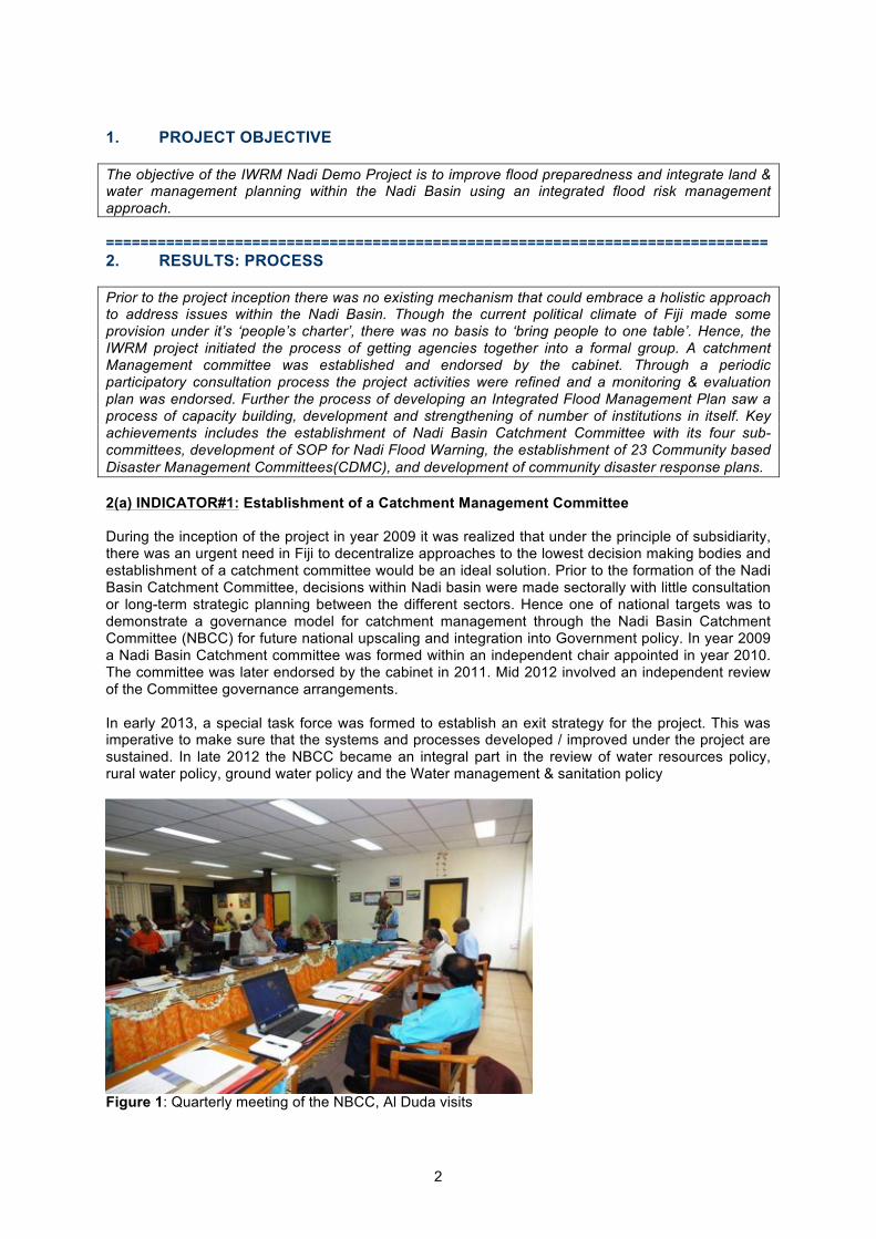
1. PROJECT OBJECTIVE The objective of the IWRM Nadi Demo Project is to improve flood preparedness and integrate land & water management planning within the Nadi Basin using an integrated flood risk management approach. ============================================================================= 2. RESULTS: PROCESS Prior to the project inception there was no existing mechanism that could embrace a holistic approach to address issues within the Nadi Basin. Though the current political climate of Fiji made some provision under it’s ‘people’s charter’, there was no basis to ‘bring people to one table’. Hence, the IWRM project initiated the process of getting agencies together into a formal group. A catchment Management committee was established and endorsed by the cabinet. Through a periodic participatory consultation process the project activities were refined and a monitoring & evaluation plan was endorsed. Further the process of developing an Integrated Flood Management Plan saw a process of capacity building, development and strengthening of number of institutions in itself. Key achievements includes the establishment of Nadi Basin Catchment Committee with its four sub-committees, development of SOP for Nadi Flood Warning, the establishment of 23 Community based Disaster Management Committees(CDMC), and development of community disaster response plans. 2(a) INDICATOR#1: Establishment of a Catchment Management Committee During the inception of the project in year 2009 it was realized that under the principle of subsidiarity, there was an urgent need in Fiji to decentralize approaches to the lowest decision making bodies and establishment of a catchment committee would be an ideal solution. Prior to the formation of the Nadi Basin Catchment Committee, decisions within Nadi basin were made sectorally with little consultation or long-term strategic planning between the different sectors. Hence one of national targets was to demonstrate a governance model for catchment management through the Nadi Basin Catchment Committee (NBCC) for future national upscaling and integration into Government policy. In year 2009 a Nadi Basin Catchment committee was formed within an independent chair appointed in year 2010. The committee was later endorsed by the cabinet in 2011. Mid 2012 involved an independent review of the Committee governance arrangements. In early 2013, a special task force was formed to establish an exit strategy for the project. This was imperative to make sure that the systems and processes developed / improved under the project are sustained. In late 2012 the NBCC became an integral part in the review of water resources policy, rural water policy, ground water policy and the Water management & sanitation policy
!
! "#!
!!!!!!!!!!!!!!!
Left: MoU signing with library services Through the effective collaboration of the IWRM Project, Land & Water Resource Management Division and the Library Services of Fiji resulted in the signing of a Memorandum of Understanding to carry out “water literacy” awareness in schools of the Western Division with more emphasis on the Nadi Basin catchment. Activities to be implemented included Oratory, Quizzes, Story Book, Debates and Talent Contests.
Above: Water literacy The launch of the water literacy campaign awareness in schools in was to create a forum and a platform where the young generation can express their views, ideas and perceptions freely in regards to the better management of our land and water resources. This activity is ongoing and being implemented by the Western Regional Library Services with the completion of an Oratory and Story Book Contest. Right: Al Duda Visit (18 July 2011) The inauguration of the GEF Secretariat – Dr Alfred Duda was a highlight for the project as being one of the participating IWRM countries to showcase its work carried out to date.
Below: Nausori Highlands Plateau A Birds eye view of the Nadi Basin catchment is easily done while standing on the Nausori Highlands Plateau. One is able to view the different topography and degradation of the catchment that needs immediate attention.
Figure 1: Quarterly meeting of the NBCC, Al Duda visits

3
2(b) INDICATOR #2: Project Design and PM&E Plan endorsed by the Project Steering Committee The design of this project dictated that proposed activities would be refined during the first six months of the project in close consultation with stakeholders. A participatory approach was to be utilized to ensure that the project includes communities and wider stakeholders as part of a participatory monitoring and evaluation plan. It was targeted that the PM&E will be implemented by August, 2011. The project activities were refined by early 2010 whilst by end of 2010 the PM&E was implemented and endorsed by the Nadi Basin Catchment Committee. This was further reflected in the mid-term review of the project as well.
2(b) INDICATOR #2 Project Design and PM&E Plan endorsed by the Project Steering Committee The design of this project dictated that proposed activities would be refined during the first six months of the project in close consultation with stakeholders. A participatory approach was to be utilized to ensure that the project includes communities and wider stakeholders as part of a participatory monitoring and evaluation plan. It was targeted that the PM&E will be implemented by August, 2011. The project activities were refined by early 2010 whilst by end of 2010 the PM&E was implemented and endorsed by the Nadi Basin Catchment Committee. This was further reflected in the mid-term review of the project as well.
Figure 2 After the devastating floods of 2012, key stakeholders realigning and prioritizing some of the project activities
2(c) INDICATOR#3: Nadi Basin Integrated Flood Management Plan Inline with the objective of the project an Integrated Flood Risk Management Plan was to be developed. In order to have this plan in place a number of processes had to be initiated. Part of the process was the establishment of an early warning system and setting up of community based disaster management committee (CDMC) by 2011. By mid of 2012, an integrated flood warning system and 14 CMDC’s were established.
3
Figure 2: After the devastating floods of 2012, key stakeholders realigning and prioritizing some of the project activities 2(c) INDICATOR#3: Nadi Basin Integrated Flood Management Plan Inline with the objective of the project an Integrated Flood Risk Management Plan was to be developed. In order to have this plan in place a number of processes had to be initiated. Part of the process was the establishment of an early warning system and setting up of community based disaster management committee (CDMC) by 2011. By mid of 2012, an integrated flood warning system and 14 CMDC’s were established. The first draft of the Integrated Flood Risk Management Plan has been presented to the NBCC on 28th August, 2013. 2(d) INDICATOR#4: Sectoral engagement in formal multilateral communication on water issues The project was designed to use a key concept that is decentralization and a principle of IWRM whereby decisions was to be taken at the lowest appropriate level following full public consultation (the principle of subsidiarity). It was targeted to have an improved coordination and cross-sectoral working relationship amongst land and water management stakeholders and communities in the catchment. With the formation of the catchment committee and the initiation of number of cross sectoral activities by the project, there has been an increased interaction between institutions and agencies. Example the formation of the SOP for the flood siren has aligned a number of agencies to collaborate and work together. The PMU continues to work in collaboration with number of its strategic partners to communicate issues on water resources. The PMU along with The University of Fiji marked the World Water Day with creative and comprehensive programs expanding to include the whole western division of Viti Levu, Fiji. Awareness and capacity building workshops and programs were expanded across the catchment targeting marginalized and vulnerable communities. The project has presented in number of joint forums such as Disaster, Climate change and National Integrated coastal Management.

4
Figure 3 Simulation exercise for CDMC members run by disaster response agencies
2(d) INDICATOR#4: Sectoral engagement in formal multilateral communication on water issues The project was designed to use a key concept that is decentralization and a principle of IWRM whereby decisions was to be taken at the lowest appropriate level following full public consultation (the principle of subsidiarity). It was targeted to have an improved coordination and cross-sectoral working relationship amongst land and water management stakeholders and communities in the catchment. With the formation of the catchment committee and the initiation of number of cross sectoral activities by the project, there has been an increased interaction between institutions and agencies. Example the formation of the SOP for the flood siren has aligned a number of agencies to collaborate and work together.
Figure 4 Sectoral engagement discussing issues related to water resources, including the Commissioner West, Police Department, Military, and Project Management Unit
4
Figure 3: Sectoral engagement discussing issues related to water resources, including the Commissioner West, Police Department, Military, and Project Management Unit 2(e) INDICATOR#5: Proportion of community engaged in water related issues to reduce vulnerability of water resources. During inception it was established that water resources in the catchment were vulnerable to human activities and there was an urgent need to create awareness and empower communities. The target was to have at least 30% active engagement of the community in water related issues. In early 2011, IWRM water literacy program was launched in schools in the catchment which saw most of the schools actively involved in water related activities. Further there had been increase in number of communities and schools involved in the save the tree program. In 2013 the Inter-Secondary Western Division IWRM Quiz competition was launched during the World Water Day celebration at the University of Fiji. This outreach and initiative was only possible through active collaboration between the Project with support from the University of Fiji and Ministry of Education. This quiz involved 50 secondary schools in the western division that provided a platform for young children to express their views on environmental issues, natural resources and the importance of sustainability.
Figure 4 Winners of IWRM Eco Quiz showing off their spoils. Courts Fiji Manager West handing over a Laptop to the winning school

5
2(e) INDICATOR#5: Proportion of community engaged in water related issues to reduce vulnerability of water resources. During inception it was established that water resources in the catchment were vulnerable to human activities and there was an urgent need to create awareness and empower communities. The target was to have at least 30% active engagement of the community in water related issues. In early 2011, IWRM water literacy program was launched in schools in the catchment which saw most of the schools actively involved in water related activities. Further there had been increase in number of communities and schools involved in the save the tree program.
Figure 5 Nadi residents from all walks of life participating in the launch of IWRM Nadi Demo/ Dept. Education Water Literacy Program
5
Figure 5: Nadi residents from all walks of life participating in the launch of IWRM Nadi Demo/ Dept. Education Water Literacy Program 2(f) INDICATOR#6: Lessons learned incorporated into other project(s), catchment flood management plans and/or Regulations The project aimed to replicate lessons learned by the end of the project. The project shared a number of lessons learnt at various levels and in varied capacity. The Project Manger attended a three-day consultation session to provide the Voh-Koné-Pouembout Water Management Committee (CGE VKP) with practical ways to move forward on its own governance and to discuss possible means of improvement for New Caledonia as a whole. The PMU-IWRM presented to the Sigatoka stakeholders on the activities carried out in the Nadi Catchment with the intention that it will be incorporated in the to build flood resilient communities within the Sigatoka catchment.

6
Figure 7:Presentation to the Sigatoka Town council stakeholders 2(g) INDICATOR#7: National staff across institutions with IWRM knowledge and experience Prior to the project, staff across the water sector had limited knowledge or practical experience of IWRM practice or concepts. The aim of the project was to increase through various activities. From inception to date, IWRM Nadi Demo Project has been instrumental in building capacity of national staff in the Fiji Meteorological Services and Water Authority of Fiji. It has also provided specific training in advance telemetry and hands-on training hydro-met station installation. In collaboration with International Union for Conservation of Nature , the project has been able to build capacity of core NCCC stakeholders in the use of key technical and management support tools developed by the global WANI and other tools, as well as to encourage the integration of the ecosystem based ‘ridge-to-reef’ concepts and principles in the Nadi River Catchment Management 2(h) INDICATOR#8: Replication strategy developed and implemented to mainstream lessons
learned To ensure the continuing success of lessons learned throught the IWRM project a replication strategy was to be developed through the project. The replication strategy will need to reflect the roles and responsibilities in mainstreaming the lessons learnes. The Replication strategy has been developed and number of initiatives has been mainstreamed in the local and national level.
Figure 6: Landowner posing a question on SLM activities
Figure 8: Discussion of IWRM at NBCC meetings

7
i. Disaster Response Plan was developed only for one village , with success of it , it is now being replicated around the catchment – there are a total of 27 such committees. This has also been replicated in the sister catchment – Sabeto . Further this has been adopted by the National Disaster Management Committee and was also replicated in the Ba catchment.
ii. With the lesson learnt from the previous events, a standard operating procedure for disaster response was developed and is now part of the district disaster management plan for the District Disaster Management Committee.
iii. Water level Stations piloted by the project are now being replicated around the country by the Fiji Meteorology Services – Flood Forecasting Unit.
iv. Establishment of IWRM Learn Corner at National Library Services of Fiji
!"#$%#&'()*+*,#-.(/(0"#$%#&'(*(1#2*2-34(5*&*'363&-(73*6/(83-9:4;#&'(/(<03#&'(3.32(3*42(:=(432+:&23(*'3&,#32(<(
============================================================================= 3. RESULTS: STRESS REDUCTION The Nadi Basin has experienced rapid urbanization and increasing population in recent years. There has also been aggressive deforestation and agriculture in the upper catchment. This has led to increased stress on water resources in the catchment and in-turn increased vulnerability of the communities to natural disasters such as flooding. The aim of the IWRM Nadi Demo project is to reduce stress on the water resources and to build flood resilient communities. Key achievements o fthe project to date include establishment launch of ‘save the tree’ program , water literacy program in
Figure 9: IWRM Learn Corner at National Library Services of Fiji

8
schools , the establishment of a landcare group, the establishment two demo plots and three nurseries. A total of 1800 coconuts plants and 554 fruits trees have been established across the catchment. Rehabilitation has now extended to the lower part of the catchment especially along the river banks. 3(a) INDICATOR#1: Sustainable forest & land management practices established and trialed with landowners to reduce runoffs and sediment loads A bio-physical survey of the Nadi Basin catchment was conducted mid 2010 and it established that majority areas of the upper catchment are of grasslands. It was further determined that landuse practices in the upper catchment, mid catchment and riparian zones contributed to heavy runoff and sediment pollution. It was targeted to establish demonstration plots and to train farmers in best agricultural practices. Three demonstration sites were established with the formation of a Landcare group in the upper catchment. Unfortunately in 2013 rehabilitation work had to be carried out to the nursery in Navunitawa that was destroyed in the cyclone Evans.
============================================================================= 3. RESULTS: STRESS REDUCTION The Nadi Basin has experienced rapid urbanization and increasing population in recent years. There has also been aggressive deforestation and agriculture in the upper catchment. This has led to increased stress on water resources in the catchment and in-turn increased vulnerability of the communities to natural disasters such as flooding. The aim of the IWRM Nadi Demo project is to reduce stress on the water resources and to build flood resilient communities. Key achievements of the project to date include establishment launch of ‘save the tree’ program , water literacy program in schools , the establishment of a landcare group, the establishment two demo plots and three nurseries. A total of 1800 coconuts plants and 554 fruits trees have been established across the catchment. 3(a) INDICATOR#1: Sustainable forest & land management practices established and trialed with landowners to reduce runoffs and sediment loads A bio-physical survey of the Nadi Basin catchment was conducted mid 2010 and it established that majority areas of the upper catchment are of grasslands. It was further determined that landuse practices in the upper catchment, mid catchment and riparian zones contributed to heavy runoff and sediment pollution. It was targeted to establish demonstration plots and to train farmers in best agricultural practices. In 2011, two demonstration sites were established with the formation of a Landcare group in the upper catchment.
Figure 6 A housewife from Nausori Highlands Village receiving her certificate from a Forestry Dept. Official after successfully completing training on nursery establishment and plant care
6
Figure 10: A housewife from Nausori Highlands Village receiving her certificate from a Forestry Dept. Official after successfully completing training on nursery establishment and plant care 3(b) INDICATOR#2: Rehabilitation of degraded areas, two ‘hotspots’ in the catchment Inline to its objective of using an integrated flood risk management approach to improve flood preparedness and management within the Nadi Basin, the project has identified two ‘hot spots’ covering an area of approximately 80 hectares. These areas were once covered with native forests however over the years some areas have been commercially forested, removed for personal use by the communities and destroyed by uncontrolled burning. The target was to rehabilitate these areas. In early 2011 two incentive based tree planting initiatives were in launched – “growing money on trees” and “we got it from tree” were conceptualized for schools and communities respectively. To date about 60 hectares of the area has been rehabilitated with fruit trees and staple food trees- coconut and breadfruit trees.

9
3(b) INDICATOR#2: Rehabilitation of degraded areas, two ‘hotspots’ in the catchment Inline to its objective of using an integrated flood risk management approach to improve flood preparedness and management within the Nadi Basin, the project has identified two ‘hot spots’ covering an area of approximately 80 hectares. These areas were once covered with native forests however over the years some areas have been commercially forested, removed for personal use by the communities and destroyed by uncontrolled burning. The target was to rehabilitate these areas. In early 2011 two incentive based tree planting initiatives were in launched – “growing money on trees” and “we got it from tree” were conceptualized for schools and communities respectively. To date about 60 hectares of the area has been rehabilitated with fruit trees and staple food trees- coconut and breadfruit trees.
7
!"#$%&'$()*+&(&&*,-- .)+/-0*-%&1&
2'3&/$4**-%5()6&70048)*&9/-)-%&:4,&*"-&0"#$%&&;<=&%-/4+#*-%&:4,&-(0"&/$()*&/$()*-%
>&?-(,&$(*-,&@ #)+/-0*-%&(A(#)&19B&;<CD&<E&:4,&*"-&)-F*&?-(,
!4)0-/*&9)-
Figure 7 A hot spot area in the Nadi being revegetated with the support of Nadi IWRM
Figure 11: A hotspot area in Nadi being re-vegetated. 3(c) INDICATOR#3: Construction of Flood mitigation structures Target: Establish flood management Structures to reduce impact of flooding Result: With the effort of ridge to reef , a holistic catchment management , technical solutions are also part of the integrated approach. A total of three retention dams were constructed to assist in managing flood waters Photo and Caption 3(d) INDICATOR#4: Integrate health issues into catchment management- healthy community, safer community
Figure 12: Retention Dam in the Upper Catchment – there are two more of the similar design
10
The aim was to bring out most of the senior members of the NBCC (PS, Directors, Divisional Heads), and its partners out of their ‘business as usual’ to have time to reflect on their personal health. – promote healthy life style. Result:, Vital resource component for any institution or management process is the human interaction / capital. Hence it was imperative that we need to invest and manage human capital well to have a vibrant workforce and healthy community. According to the Ministry of Health’s Non-Communicable Diseases (NCDs) Prevention and Control Strategic Plan 2010-2014, NCDs are casting deadly shadows on Fiji’s population dubbed as the “silent killers” are preying on our working population and our children. Put simply, they cause 82 percent of deaths in the country each year. Nadi Basin Catchment Committee along with it strategic partner Ministry of Health Nadi organized an IWRM NCD Health Trek on the 6th of December, 2012. The mountain trek was very successful with an active participation of around 100 senior executives.
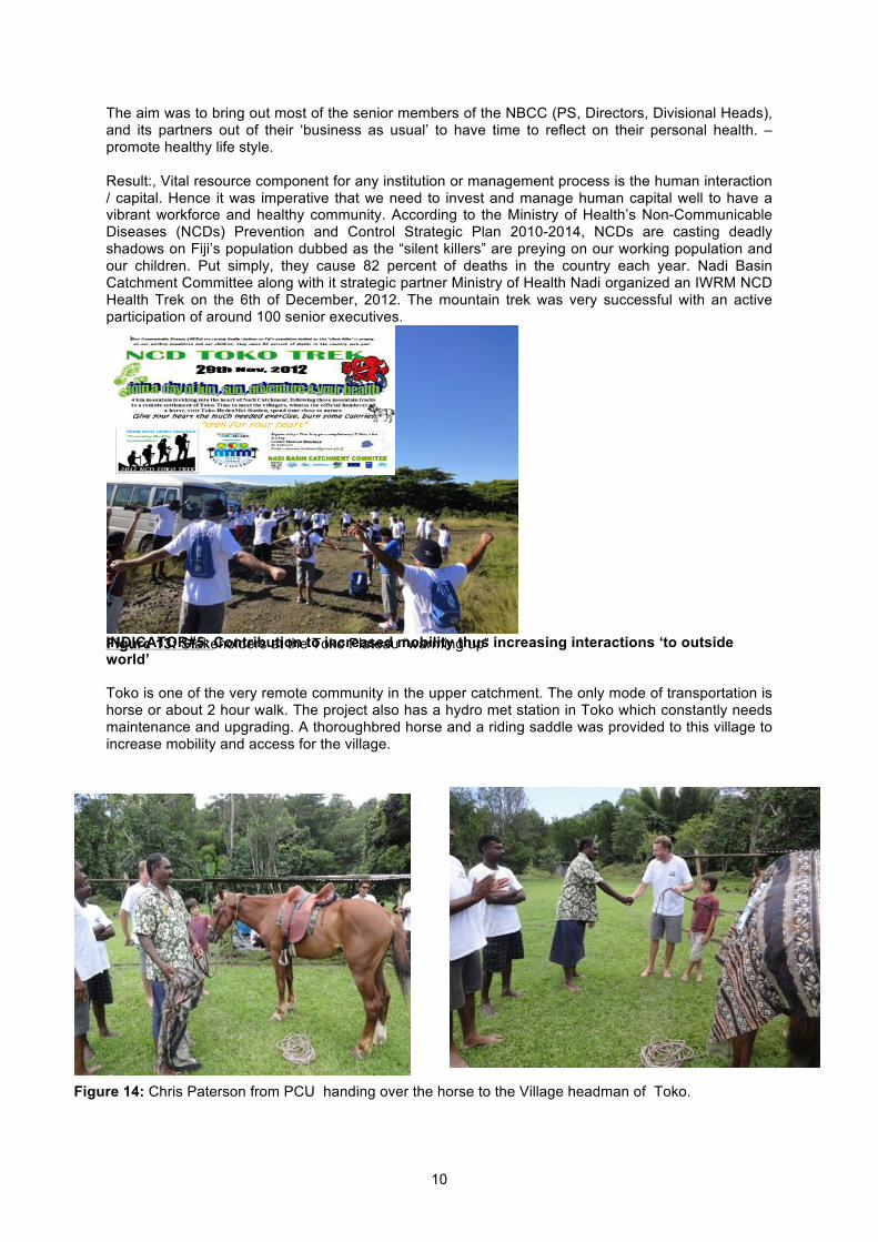
INDICATOR#5: Contribution to increased mobility thus increasing interactions ‘to outside world’ Toko is one of the very remote community in the upper catchment. The only mode of transportation is horse or about 2 hour walk. The project also has a hydro met station in Toko which constantly needs maintenance and upgrading. A thoroughbred horse and a riding saddle was provided to this village to increase mobility and access for the village.
Figure 13: Stakeholders at the Toko Plateau “warming up”
Figure 14: Chris Paterson from PCU handing over the horse to the Village headman of Toko.