implementing the land governance assessment … the land governance assessment framework ... it has...
TRANSCRIPT
TS 3A – Land Governance for Sustainable Development, Commission 7 Tony BURNS, Klaus DEININGER, Harris SELOD, and Kate DALRYMPLE Implementing the Land Governance Assessment Framework FIG Congress 2010 Facing the Challenges - Building the Capacity Sydney, Australia, 11-16 April 2010
1/21
Implementing the Land Governance Assessment Framework*
Tony BURNS, Klaus DEININGER, Harris SELOD and Kate DALRYMPLE
Key words: land administration, land policy, governance indicators SUMMARY This article provides a brief description of key features of the Land Governance Assessment Framework (LGAF) and reports on initial experience in four pilot countries. LGAF is used in a country as a means to evaluate the legal framework as well as policies and practices regarding land and land use. The LGAF builds on 21 indicators in five thematic areas including the Legal and Institutional Framework; Land Use Planning, Management and Taxation; Management of Public Land; Public Provision of Land Information; and Dispute Resolution and Conflict Management. Within each thematic area, a series of indicators has been developed with a subset of dimensions that establish a specific line of enquiry for investigation, quantitative measurement or qualitative assessment. It is motivated by the fact that land policy analyses and interventions are often fragmented and by taking a view that focuses only on specific aspects (e.g. land administration or surveying) may not only miss important synergies to other parts of the system but, in the end also prove to be ineffective and unsustainable. The pilot experience allows identification of the instrument’s potential and of areas for improvement. It has also produced results of land governance best practices and opportunities for improvement in the pilot countries: Peru, Ethiopia, Kyrgyzstan and Tanzania. * The interpretations and conclusions expressed in this paper are the authors and do not represent the view of the World Bank, its Executive Directors, or the countries they represent.
TS 3A – Land Governance for Sustainable Development, Commission 7 Tony BURNS, Klaus DEININGER, Harris SELOD, and Kate DALRYMPLE Implementing the Land Governance Assessment Framework FIG Congress 2010 Facing the Challenges - Building the Capacity Sydney, Australia, 11-16 April 2010
2/21
Implementing the Land Governance Assessment Framework
Tony BURNS, Klaus DEININGER, Harris SELOD and Kate DALRYMPLE 1. LAND SECTOR GOVERNANCE 1.1 Background
Land and the nature of land management and administration present some unique challenges that can complicate the state’s ability to play its necessary roles of recognizing and enforcing property rights, managing public land, and providing associated land management and administration services. In practice, land and resource uses are often complicated and rapidly evolving and this has important consequences where the provision of secure property rights is concerned. For example, the interests of nomadic herders may conflict with those of sedentary farmers; local communities may prefer a system that is flexible and relies on local institutions, while the interests of commercial investors are served by greater consistency and clarity operating through the formal legal system. Shifting demographic patterns and economic forces mean that these confluences of interests are continuously being reconfigured and redefined. It has been difficult to accommodate these changes in land management and administration systems that typically have limited capacity and effectiveness.
The land sector is particularly susceptible to corruption and rent seeking. Land is an enormously valuable asset, typically accounting for 30-50% of national wealth in developing countries (Kunte A et al. 1998). The value of land thus creates a significant opportunity for corruption on the part of those with the legal authority to assign, revoke, or restrict rights to it. High profile land grabs and illegal state land capture are being exposed across a number of African nations. While petty corruption is embedded in many public institutions, often land administration, this too can be costly, and is estimated at US $700 million per annum in India. Transparency International, in reporting on public perception of corruption in seven public sectors in five countries in South Asia, noted that land administration was perceived as the second sector most prone to corruption in Pakistan and the third most prone to corruption in India, Bangladesh and Sri Lanka (Thampi, 2002:2).
Land scarcity and demand in both urban and rural areas are also driving factors increasing the pressure on good governance of land administration and management systems. Population growth and urbanization have a significant impact on driving up land value which affects housing and property affordability in the context of difficulties implementing planning functions and zoning regulations. In the rural areas there are increasing demands and land values for new land uses, such as biofuel agriculture or forest reserves for carbon offsetting. While the global community debate on issues of food security, this new large scale foreign investment market puts pressure on traditional land owners and state land held for public good. This new market is also bringing into play a new range of stakeholders, also known as ‘middlemen’, to approve regulatory requirements and international certifications. All the while, effective access to secure property rights and land use underpins investment, poverty reduction and economic growth.
TS 3A – Land Governance for Sustainable Development, Commission 7 Tony BURNS, Klaus DEININGER, Harris SELOD, and Kate DALRYMPLE Implementing the Land Governance Assessment Framework FIG Congress 2010 Facing the Challenges - Building the Capacity Sydney, Australia, 11-16 April 2010
3/21
Development practitioners of all persuasions recognize the importance of governance and the rule of law as an essential precondition for economic and social development. Given the complexity of land issues virtually everywhere and the fact that institutional arrangements are highly country specific there is a strong need for systematic guidance to diagnose and benchmark land governance and to contribute to improving the situation over time. In response, a diagnostic tool for the evaluation of the legal framework, policies and practices regarding land and land use, has been designed and tested in a few pilot countries. This Land Governance Assessment Framework (LGAF) is meant to assess the land governance situation at the country level, identify the key issues for improvement, and may be implemented at different points in time to monitor progress in land governance. It can also be used comparatively to identify best practices that can determine benchmarks for other countries. 1.2 Elements of land sector governance
Land sector governance provides oversight for the wide scope of functions and systems within the land administration and land management interests of governments, private sector and civilians. The state is responsible for performing the following three functions:
The definition and enforcement of a system of to recognize property rights and obligations, for groups or individuals, to facilitate investment while mitigating externalities and optimizing social outcomes.
The management, acquisition, and disposition of land in cases of public ownership.
Maintenance of records and provision of information services to facilitate transactions.
In performing these functions, the state adheres to the following criteria which employ the fundamentals of good governance:
Representatives of the state perform their role effectively and efficiently in accordance with underlying justification.
Where value judgments must be made and conflicting interests reconciled, decisions at all levels are the result of a participatory, transparent, and socially legitimate process.
Institutions of land administration act in accordance with clearly defined laws and procedures that guarantee appropriate exercise of authority.
The Land Governance Assessment Framework (LGAF) evolved over the past 2 years and has been refined to five key thematic areas as a platform for monitoring elements in the sector. The legal and institutional area investigates how property rights to land (for groups or individuals) are defined, can be exchanged, and transformed. The land use, management and taxation theme considers the way land is managed, land use plans and regulations are prepared and implemented, and how land is taxed. More specifically a theme is devoted to public land management, to probe into what state land is accounted for, how is it managed, acquired and disposed of. The fourth thematic area investigates the nature and quality of land ownership/use information available to the public, and the ease with which it can be accessed or modified. Important in terms of outcomes and consequences of social fabric and the ability
TS 3A – Land Governance for Sustainable Development, Commission 7 Tony BURNS, Klaus DEININGER, Harris SELOD, and Kate DALRYMPLE Implementing the Land Governance Assessment Framework FIG Congress 2010 Facing the Challenges - Building the Capacity Sydney, Australia, 11-16 April 2010
4/21
of a land administration and management system to deal with conflict, is for the framework to consider the way in which disputes are resolved and conflict is managed. 1.3 Methodology for Monitoring land governance
The final version of the Land Governance Assessment Framework (LGAF) evolved through a number of reviews. To address the broad nature of the land sector and difficulties of evaluating factors of comparative replicability across countries, indicator subjectivity, source reliability and effective use of limited data collection resources, an indicator framework based approach was favored. The Public Expenditure and Financial Accountability (PEFA) Performance Measurement Framework approach was identified as a model that could comprehensively incorporate original draft indicators that were developed based on an in-depth literature review and lessons from experience in the land sector. The Performance Measurement Framework for Public Financial Management was developed under the assumption that “effective institutions and systems of public financial management have a critical role to play in supporting implementation of policies of national development and poverty reduction” (PEFA Secretariat 2005). Using a similar framework development approach as the Public Financial Management, wide international consultations with country-level testing was used to formulate LGAF. Both were developed with the intentions of contributing to collective efforts of stakeholders to assess systems and gather comparative information for measurement and monitoring of fundamental systems for country level development (PEFA Secretariat 2005). Key stages in the development of the LGAF were:
1. The methodology adopted for the LGAF is based on the methodology adopted in developing the Public Expenditure and Financial Accountability (PEFA, see www.pefa.org) assessment framework. The framework is made up of a range of indicators that are then ranked as a performance measure relevant to a specific theme.
2. The LGAF is structured on five thematic areas that are based on lessons from land sector experience with a coherent set of 21 indicators (refer to attached Appendix).
3. Within each indicator a set of dimensions totaling 80, between 2 and 6 per indicator, was developed. These were a necessary subset for describing the complex dimensions of land governance. For each dimension, a set of pre-coded statements were developed, as per the PEFA methodology. These statements describe four situations graded from A through to D. These dimensions and A-B-C-D statements were developed and refined in an iterative manner.
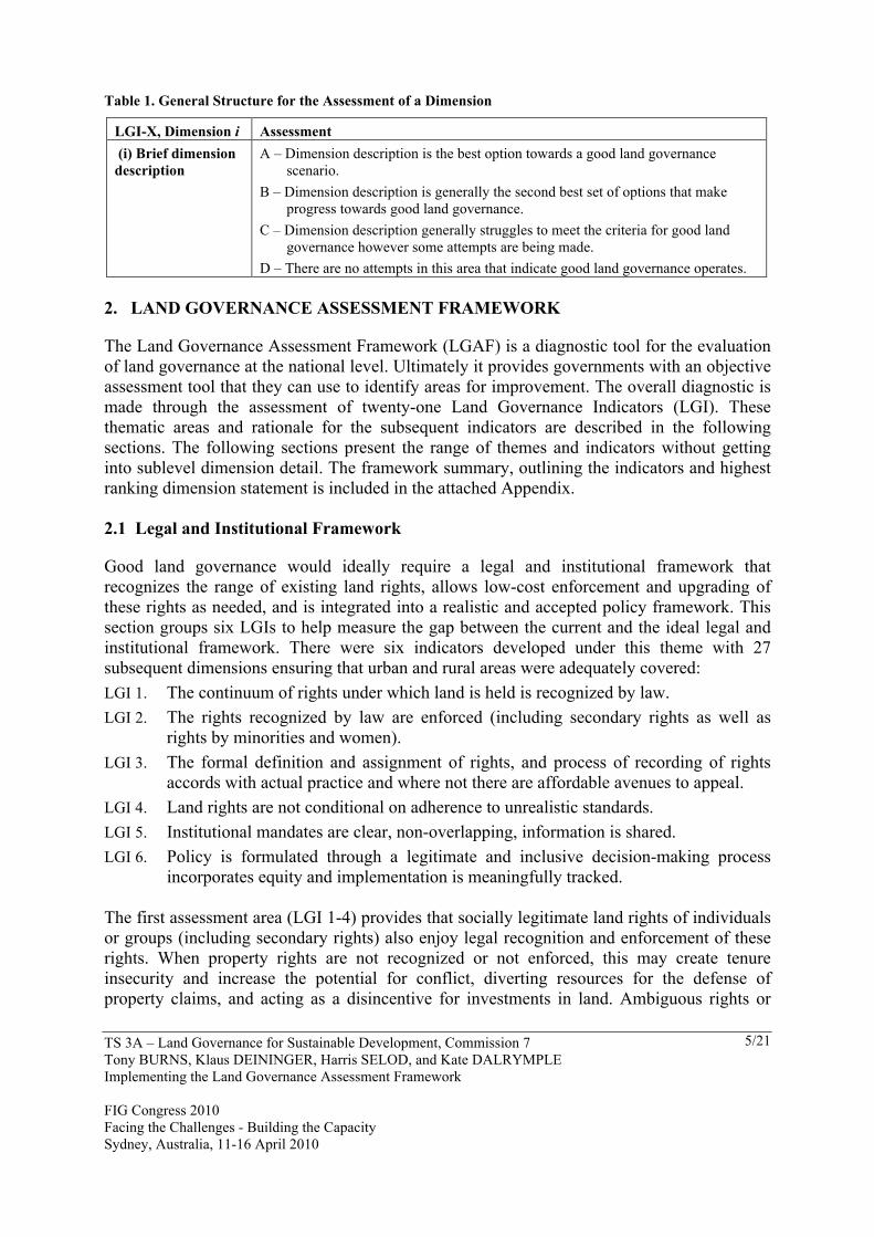
Therefore the LGAF is made up of 80 dimensions, framed into a box, (similar to the illustration below, Table 1. where a group of experts decide which of the corresponding statements best represents that land governance context in their jurisdiction. These dimension or indicator scores are performance measures that can be discussed by policy makers and development partners.
TS 3A – Land Governance for Sustainable Development, Commission 7 Tony BURNS, Klaus DEININGER, Harris SELOD, and Kate DALRYMPLE Implementing the Land Governance Assessment Framework FIG Congress 2010 Facing the Challenges - Building the Capacity Sydney, Australia, 11-16 April 2010
5/21
Table 1. General Structure for the Assessment of a Dimension
LGI-X, Dimension i Assessment (i) Brief dimension description
A – Dimension description is the best option towards a good land governance scenario.
B – Dimension description is generally the second best set of options that make progress towards good land governance.
C – Dimension description generally struggles to meet the criteria for good land governance however some attempts are being made.
D – There are no attempts in this area that indicate good land governance operates. 2. LAND GOVERNANCE ASSESSMENT FRAMEWORK
The Land Governance Assessment Framework (LGAF) is a diagnostic tool for the evaluation of land governance at the national level. Ultimately it provides governments with an objective assessment tool that they can use to identify areas for improvement. The overall diagnostic is made through the assessment of twenty-one Land Governance Indicators (LGI). These thematic areas and rationale for the subsequent indicators are described in the following sections. The following sections present the range of themes and indicators without getting into sublevel dimension detail. The framework summary, outlining the indicators and highest ranking dimension statement is included in the attached Appendix. 2.1 Legal and Institutional Framework
Good land governance would ideally require a legal and institutional framework that recognizes the range of existing land rights, allows low-cost enforcement and upgrading of these rights as needed, and is integrated into a realistic and accepted policy framework. This section groups six LGIs to help measure the gap between the current and the ideal legal and institutional framework. There were six indicators developed under this theme with 27 subsequent dimensions ensuring that urban and rural areas were adequately covered: LGI 1. The continuum of rights under which land is held is recognized by law. LGI 2. The rights recognized by law are enforced (including secondary rights as well as
rights by minorities and women). LGI 3. The formal definition and assignment of rights, and process of recording of rights
accords with actual practice and where not there are affordable avenues to appeal. LGI 4. Land rights are not conditional on adherence to unrealistic standards. LGI 5. Institutional mandates are clear, non-overlapping, information is shared. LGI 6. Policy is formulated through a legitimate and inclusive decision-making process
incorporates equity and implementation is meaningfully tracked. The first assessment area (LGI 1-4) provides that socially legitimate land rights of individuals or groups (including secondary rights) also enjoy legal recognition and enforcement of these rights. When property rights are not recognized or not enforced, this may create tenure insecurity and increase the potential for conflict, diverting resources for the defense of property claims, and acting as a disincentive for investments in land. Ambiguous rights or
TS 3A – Land Governance for Sustainable Development, Commission 7 Tony BURNS, Klaus DEININGER, Harris SELOD, and Kate DALRYMPLE Implementing the Land Governance Assessment Framework FIG Congress 2010 Facing the Challenges - Building the Capacity Sydney, Australia, 11-16 April 2010
6/21
ambiguity regarding who holds the rights can reduce transactions, blocking the transfer of land to more efficient uses. The legal recognition of actual land rights is thus a key element of land governance. However, it also raises challenges: As different tenure regimes (like e.g. communal and individual rights) normally coexist in different parts of any given country, giving legal backing to existing rights requires sufficient flexibility to recognize the range of rights actually held by individuals and groups, including secondary rights where relevant. It is also important that the legal framework be able to accommodate changes in tenure practices in order to avoid that these changes result in the growth of informality. For communal tenure, this requires regulations to accompany tenure individualization or to define how user groups can organize themselves, impose internal rules, interact with the outside world, and call on external agencies to enforce rules.
In addition, rules limiting ownership rights should be based on rational justifications that may include consideration of environmental, health, security and other factors and do not drive the population into informality.
A second area (LGI 5-6) within the legal and institutional framework is to ensure that land institutions have clear mandates, and that policies are fair, non-discriminatory, and reflect social preferences. Overlaps or gaps in mandates or actual functions performed by land administration institutions (either horizontally or vertically) allow for discretion, which may cause ambiguity and increase transaction costs for those who need to use these institutions, thereby pushing potential users into informality. They can also create confusion or parallel structures that can threaten the integrity and reliability of documents and information provided by land sector institutions, thus undermining confidence in property rights and creating threats to good governance.
Land policies are the key drivers of land governance. To avoid capture by special interest groups, they need to be developed in an open and transparent process should take into account the availability of other policy instruments to achieve similar goals. Moreover, policy goals and responsibilities by the different institutions in the land sector should be clearly articulated, mechanisms to regularly assess the extent to which these goals are achieved should be available, and policy adjustments should be made in case the overall goals are not being achieved as planned. 2.2 Land Management and Taxation
Good governance requires regulations for land use planning, management and taxation that can be enforced and that rely on a broad consensus. The regulations for land use planning and management should be justified on the basis of public interest, while land-related taxation should be transparent and cost-effective. Investigations are made upon the principle that limitations on the ability to exercise property rights on land (including planning restrictions) are justified and determined in a transparent and efficient fashion, while exemptions are granted promptly and transparently, and that taxes on land and real estate should be transparently determined and efficiently collected. Five indicators and 17 dimensions assess management and taxation:
TS 3A – Land Governance for Sustainable Development, Commission 7 Tony BURNS, Klaus DEININGER, Harris SELOD, and Kate DALRYMPLE Implementing the Land Governance Assessment Framework FIG Congress 2010 Facing the Challenges - Building the Capacity Sydney, Australia, 11-16 April 2010
7/21
LGI 7. Changes in land use are made in a transparent fashion; benefit society as a whole. LGI 8. Land use plans and regulations are affordable and justified to ensure large parts of
the population are not driven into informality; able to cope with population growth. LGI 9. Development permits are granted promptly and transparently. LGI 10. Tax valuations clear, uniformly applied, regularly updated, publicly accessible. LGI 11. Land and property taxes are collected; generate positive yield. Land use and management regulations, including land use planning mechanisms and zoning restrictions, can have significant impact on land governance (LGI 7-9). However, given the large changes in land values that can arise due to, for example, re-zoning of land, regulations need to be justified in terms of cost-effective provision of public goods (environmental quality or public services) or avoidance of undesirable externalities from land use (e.g. prohibition of industrial activity in, or close to, residential areas). Private information on planned zoning regulation can allow capture of huge amounts of rents, prompting corruption, implying that, where they are justified, such regulations should be decided upon in a transparent and participatory way. Any land use restriction will need to be designed keeping in mind the resources required to enforce such rules, the affordability of compliance, and mechanisms to bring reality in line with land use restrictions in cases where there are differences. Conflicts of interest (e.g. the government being at the same time regulator, land owner and judge) will be conducive to defective governance. Imposing restrictions that are beyond the reach of the majority of the population or that cannot be enforced consistently provides huge opportunities for a discretionary application of rules and bad governance. Beyond good governance and clear processes, the ability to obtain permissions for restricted land uses (e.g. building permits) in a quick, affordable and transparent manner is also important economically; if this is not the case, this can lead to inefficiency in resource allocation and reduced investment and economic development given the uncertainty and the costs associated with the procedure. In areas where land values are high (e.g. urban areas), taxation of land can generate significant revenues for local government and generate important incentives against land speculation (LGI 10-11). However, land taxation is politically controversial and as a result there is great variety in the ways that property taxes are assessed and collected. In many countries, the lack of revenue from property tax impacts on the scope for local governments to provide the needed services and in some cases the lack of realistic taxation on capital gains contributed to speculative bubbles in the land market. Allowing for a more uniform implementation of land taxation will require attention to both technical issues (clear principles for valuation to avoid arbitrariness, regular updating of valuation rolls, capacity for efficient collection) and policies in order to generate appropriate incentives (retention by local governments, tax exemptions).
TS 3A – Land Governance for Sustainable Development, Commission 7 Tony BURNS, Klaus DEININGER, Harris SELOD, and Kate DALRYMPLE Implementing the Land Governance Assessment Framework FIG Congress 2010 Facing the Challenges - Building the Capacity Sydney, Australia, 11-16 April 2010
8/21
2.3 Public Land Management
Good governance requires transparent and accountable management of public land for the public interest, including processes by which land is acquired and released by the State. It is important that the state ownership of land be justified on a public-good basis and that compulsory acquisition procedures are justified (e.g. where a comparable outcome cannot be achieved through private ownership or when private ownership is likely to lead to outcomes that have undesirable impacts on public welfare in general) and exercised only for clear public purposes and managed appropriately. It is also important that transfer of rights over State-owned land be transparent and monitored. Four indicators and 16 dimensions are assigned: LGI 12. Public land ownership is justified, inventoried, with clear management
responsibilities; publicly accessible information. LGI 13. The state expropriates land efficiently and only for the public good. LGI 14. Expropriation procedures clear and transparent; compensation includes unregistered
claims and is fair and quick; expropriation and compensation can be contested. LGI 15. Transfer of public land to private use through sale or lease follows transparent,
competitive processes to generate revenue. It is crucial that state ownership of land does not displace ownership or management by individuals or communities unless justified to avoid externalities or provide public goods and services (LGI 12-13). Thereby the need for public land ownership to be justified, inventoried, under clear management responsibilities, and relevant information is publicly available. The ownership of land by governments can be justified by the provision of public goods. But in many countries, the handing out of government land is one of the most dramatic forms of corruption which remains difficult to curb unless an inventory of public land exists, the proceeds from such land are clearly identified, and the relevant institutions audited. The inability of a government to document and inventory public and state-owned land may raise questions about its ability to effectively manage those lands and whether, in this context, public ownership is justified on these lands. An inventory of public and State-owned land is needed to allow proper management as well as a means to justify those holdings. Furthermore, sound management of public land requires transparency and public availability of information regarding public land and public land management. Another principle area of investigation (LGI 14) is to ensure that the expropriation of land is justified by overall public interest, fairly compensates all those who lose rights, and follows clear and transparent processes. Expropriation is an important tool for governments to enhance social welfare by providing public goods such as roads, airports, shopping centers, irrigation or by limiting negative externalities when private ownership is likely to lead to outcomes that have undesirable impacts on welfare. But it is important that government exercise their authority for compulsory acquisition procedures only with a well-defined and transparent procedure and by fairly compensating those adversely affected in a timely manner. Failure to do so or excessive resort to expropriation can create tenure insecurity that undermines incentives for investment while large tracts of land end up accumulated in the hands of the State. Inappropriate treatment of land expropriation can also lead to social unrest and protests. It is thus important that individuals and groups who perceive to be negatively
TS 3A – Land Governance for Sustainable Development, Commission 7 Tony BURNS, Klaus DEININGER, Harris SELOD, and Kate DALRYMPLE Implementing the Land Governance Assessment Framework FIG Congress 2010 Facing the Challenges - Building the Capacity Sydney, Australia, 11-16 April 2010
9/21
affected by expropriation have access to institutions that enable them to contest the terms of their expropriation through independent and objective mechanisms. Lastly (LGI 15), the transfer of public land ownership, or use, rights must follow a clear process with revenues collected in the process being monitored and accounted for. The transfer or lease of State-owned land can be an important tool to increase the supply of land or cash in on the value of land to increase public resources. But in the absence of transparent procedures to divest public land, these transactions can be the source of corruption (e.g. bribery of government officials to obtain public land at a fraction of market value), squandering of public wealth. Publicizing transactions involving State-owned land provides public scrutiny and limits the potential for bad governance and land speculation. 2.4 Public Provision of Information
Good governance requires that land information systems provide relevant, accurate and affordable land-related information to the public and that land administration services are accessible, affordable and sustainable. Four indicators and 13 dimensions identify registry record reliability and land administration accessibility: LGI 16. Land registry is complete, relevant, and up to date and publicly available. LGI 17. Registry information sufficient to make inferences on ownership. LGI 18. Land administration services are provided in a cost-effective and sustainable manner. LGI 19. Fees are determined and collected in a transparent manner. In principal land registries should be able to provide reliable (textual and spatial) information regarding (private and public) land rights to the public (LGI 16-17). Information provided by land registries has public good characteristics, providing a strong rationale for government involvement in the recording and maintenance of the registry, allowing access to relevant land-related information to interested parties. In particular, the public availability of land-related information can inform the public about transaction possibilities and foster the development of a unified and more efficient land-market. But in order to accomplish this, the registry needs to be complete, reliable, and up to date, allowing for an easy identification of rights both spatially and by party. Secondly, land administration services should be provided in a way that is easily accessible by users, efficient, cost-effective, and sustainable (LGI 18-19). In many cases, interventions to improve land registries have been over-designed with little attention to the cost of operation, leading to either continued subsidy-dependence (and the associated danger of political influence) or lack of sustainability as users who do not see the value of paying large amounts of money to register their transactions will revert back to informality. Ensuring that operations are efficient enough to be justifiable in terms of land values and not pose undue barriers to participation is thus of great importance to prevent the registry becoming out of date very quickly. Having realistic fee schedules and paying employees competitive wages is also important to prevent that middlemen and registry officials rely on bribes for provision of quick or high quality services, therefore leading to a culture of corruption that is one of the

TS 3A – Land Governance for Sustainable Development, Commission 7 Tony BURNS, Klaus DEININGER, Harris SELOD, and Kate DALRYMPLE Implementing the Land Governance Assessment Framework FIG Congress 2010 Facing the Challenges - Building the Capacity Sydney, Australia, 11-16 April 2010
10/21
reasons why land administration ranks so highly in any independent assessments of governance. 2.5 Dispute and Conflict Resolution
The ambiguity in land rights is a major source of conflicts (because transactions occurred where land was inalienable, or because of conflicting views between traditional and formal authorities, or opportunistic re-interpretation of contracts and terminology). It is thus desirable that affordable, clearly assigned, transparent, and objective dispute resolution mechanisms exist, and that these mechanisms are sufficiently efficient to maintain the level of unresolved disputes low enough not to affect the productivity of land use or threaten social stability. These elements are measured through two indicators and seven associated dimensions: LGI 20. Conflict resolution responsibility is clearly assigned, relevant bodies are competent
in applicable legal matters, and decisions can be appealed. LGI 21. Low level and expeditious resolution of pending conflicts. The availability of accessible institutions to manage land-related conflict fairly and expeditiously, preventing accumulation of grievance and escalation of conflict is essential (LGI 20). In many developing countries, property rights systems are changing rapidly, often creating significant tensions among different value sets and the individuals whose access to resources is affected by these changes. To prevent either large-scale opportunistic behavior and the erosion of authority or a high level of persistent conflict that can easily escalate into social disruption with very negative consequences, it is important to have institutions for conflict resolution that are legitimate, legally recognized, and accessible to the majority of the population. Such institutions facilitate the management of conflicts and their authoritative resolution. This requires the existence of an independent forum with transparency and limited political discretion, and effective and affordable rules and mechanisms for appeal and dispute resolution through formal and informal mechanisms. Lastly in the governance assessment framework it is most desirable that the level of unresolved conflict/disputes is low enough to not affect the productivity of land use or threaten social stability (LGI 21). Continuing dispute that cannot be resolved authoritatively can impose huge costs not only on individuals but also on society as a whole as it will deter land investments and further development. Two main sources of such dispute are either in large scale social shifts or in inappropriate policies. In many cases, the independence of the judiciary from regular land administration institutions implies that, even though the pernicious effects of such conflicts on land administration are widely recognized, little is done to systematically resolve them, with the result that in the extreme the reliability of any information in the land system will be put into question. 3. IMPLEMENTING LGAF The process for implementing the LGAF relies on three sequential approaches, namely:
(i) Expert analysis (ii) Panels of experts
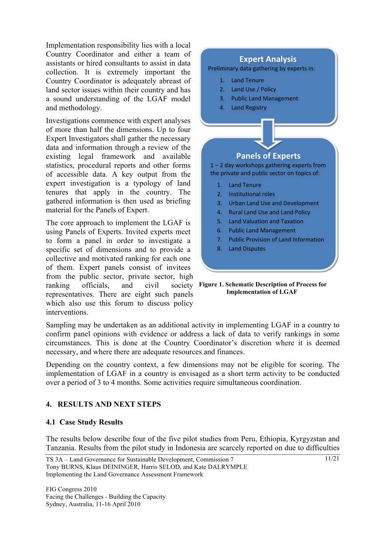
TS 3A – Land Governance for Sustainable Development, Commission 7 Tony BURNS, Klaus DEININGER, Harris SELOD, and Kate DALRYMPLE Implementing the Land Governance Assessment Framework FIG Congress 2010 Facing the Challenges - Building the Capacity Sydney, Australia, 11-16 April 2010
11/21
Implementation responsibility lies with a local Country Coordinator and either a team of assistants or hired consultants to assist in data collection. It is extremely important the Country Coordinator is adequately abreast of land sector issues within their country and has a sound understanding of the LGAF model and methodology.
Investigations commence with expert analyses of more than half the dimensions. Up to four Expert Investigators shall gather the necessary data and information through a review of the existing legal framework and available statistics, procedural reports and other forms of accessible data. A key output from the expert investigation is a typology of land tenures that apply in the country. The gathered information is then used as briefing material for the Panels of Expert.
The core approach to implement the LGAF is using Panels of Experts. Invited experts meet to form a panel in order to investigate a specific set of dimensions and to provide a collective and motivated ranking for each one of them. Expert panels consist of invitees from the public sector, private sector, high ranking officials, and civil society representatives. There are eight such panels which also use this forum to discuss policy interventions.
Sampling may be undertaken as an additional activity in implementing LGAF in a country to confirm panel opinions with evidence or address a lack of data to verify rankings in some circumstances. This is done at the Country Coordinator’s discretion where it is deemed necessary, and where there are adequate resources and finances.
Depending on the country context, a few dimensions may not be eligible for scoring. The implementation of LGAF in a country is envisaged as a short term activity to be conducted over a period of 3 to 4 months. Some activities require simultaneous coordination.
4. RESULTS AND NEXT STEPS 4.1 Case Study Results
The results below describe four of the five pilot studies from Peru, Ethiopia, Kyrgyzstan and Tanzania. Results from the pilot study in Indonesia are scarcely reported on due to difficulties
Figure 1. Schematic Description of Process for Implementation of LGAF
Expert Analysis Preliminary data gathering by experts in:
1. Land Tenure 2. Land Use / Policy 3. Public Land Management 4. Land Registry
Panels of Experts 1 – 2 day workshops gathering experts from the private and public sector on topics of:
1. Land Tenure 2. Institutional roles 3. Urban Land Use and Development 4. Rural Land Use and Land Policy 5. Land Valuation and Taxation 6. Public Land Management 7. Public Provision of Land Information 8. Land Disputes
TS 3A – Land Governance for Sustainable Development, Commission 7 Tony BURNS, Klaus DEININGER, Harris SELOD, and Kate DALRYMPLE Implementing the Land Governance Assessment Framework FIG Congress 2010 Facing the Challenges - Building the Capacity Sydney, Australia, 11-16 April 2010
12/21
implementing LGAF and large inconsistencies in reporting. Although the major objective of undertaking the pilots was to validate and refine the LGAF methodology, the results from the pilots do provide valuable insights into issues related to land governance. Key Results from indicator of Policy and Legal Frameworks: The LGAF assessment clearly demonstrates the fact that the legal recognition of rights does not imply recording of rights. In Peru communal tenure is clearly recognized under the law, yet very little is formally recorded. The failure to recognize group tenure has lead to forced individualization in a number of countries including Indonesia. In Tanzania the Village Land Act provides a sound basis for the registration of rights over the 70% of the country that is classed as village land, yet only about 10,000 certificates of customary right of occupancy have been issued under the Act despite the fact that the law sets out low cost procedures. Most countries have more than one tenure regime, but generally the transition from one regime to another was difficult or impossible. Kyrgyzstan has a clear, practical and affordable process to formally recognize unchallenged possession with a high percentage obtaining registration using non-documentary forms of evidence. However constraints on rural land ownership inhibit land market development and the consolidation process. Historically, rural land tenure in Ethiopia is better recognized than urban areas where there are high levels of informality and weaker administrative tools and structure. Institutional responsibilities are often unclear and there is very limited information sharing. There is a variety in institutional arrangements. In Tanzania the responsibility for land administration is split between the central government and local government, with the central government often blocking local initiatives. There is uncertainty in jurisdiction between the forest and land agencies in Indonesia. In Ethiopia, while there is separation in the functions of policy, implementation and dispute resolution between federal, regional and municipal levels respectively, overlap occur across Ministerial agencies and there are limited supporting guidelines below Federal level to support policy implementation. Consultative policy development and responding to equity principals in most pilot countries has received more attention in the past decade, however data reliability and the extent of monitoring of the implementation of policy was largely questionable in Ethiopia and Tanzania. Peru, without having an official land policy, deduces such guidelines from legislature which can lead to highly politicized debate and sometime violent conflict. Kyrgyzstan appeared more transparent and accountable to reporting on land policy than the other countries. Key results from indicators on land use planning, management, tax: There were marked differences in planning provisions, particularly between urban and rural areas. Most countries ranked poorly for indicators on land use planning and management as master or town plans and municipal planning capacity fail to address the demand for housing in urban areas leading to widespread informality. Building applications on the other hand are more closely adhered to in some countries as an extra-legal maneuver towards tenure security. Peru and Ethiopia boast more effective, affordable and timely procedures to obtain building permits.
TS 3A – Land Governance for Sustainable Development, Commission 7 Tony BURNS, Klaus DEININGER, Harris SELOD, and Kate DALRYMPLE Implementing the Land Governance Assessment Framework FIG Congress 2010 Facing the Challenges - Building the Capacity Sydney, Australia, 11-16 April 2010
13/21
In Tanzania there is a highly participatory process to prepare rural land use plans, but it is easy to override or change the plans. In most countries the actual use differed from the planned use. The public notice of land use changes varies widely. In most countries major urban areas were islands of planning, but even here actual and planned use often diverged. The time to review development applications varied greatly, with a very short period in Kyrgyzstan and a long period in Peru. Improved valuation can be a significant benefit to local governments however in most countries discrepancies exist between recorded and market values and the updating of valuation rolls is largely neglected, as is the case of Peru. Most of the land revenue was retained by local governments, but there was limited capacity for collection in some countries such as Tanzania where only 50-60% of assessed properties are collected. Kyrgyzstan land valuation is virtually non-existent as their taxation system is based on land categories and location rather than market prices. Ethiopia tax collection is integrated in the system of land allocation and therefore comprehensive as it serves a dual purpose in terms of revenue generation and evidence of rights. Key results from indicators on public land acquisition, management, disposal: Little public land is identified in records and this is a serious constraint on the management of public land even where the responsibility for the management of public land is clear as it is in Peru. In other countries the lack of records is exacerbated by unclear or overlapping assignment of responsibility. Ethiopia and Tanzania ranked poorly in most categories of public land management. In Kyrgyzstan however the records that exist for public land are not publicly available or accessible. There are major differences in the speed, transparency and contestability of expropriation. Kyrgyzstan and Peru demonstrated good governance for incidences of expropriation and varying results on expropriation compensation. There is fairly quick transfer of the land and fair compensation in Peru and Kyrgyzstan, but while the transfer is quick, the payment of compensation in Peru is not very timely. There is little or no compensation for the loss of non-registered rights and in some countries land use change is an undesirable means of regulatory taking. The lack of an inventory of public land also limits oversight of the disposal of public land by politicians and officials. In Peru public land is disposed of through auction and there is prompt collection of lease payments for leased public land. However there are major losses of fiscal revenue due to the disposal of public land at very low prices in Tanzania and Kyrgyzstan. A serious neglect of public land management exists in Ethiopia where most reports indicate that wildlife reserves and game parks exist in paper only. Expropriation of land is largely falling in the hands of large commercial investors and used as a mechanism to expand urban areas through secretive non-transparent bidding processes. Key results from indicators on land information provision and dispute resolution: The coverage, currency and benefits from the registration systems differ. There is an over-centralized, supply-driven system in Tanzania with limited outreach. There are major differences in the cost-effectiveness and sustainability of the land registration systems. In Peru and Kyrgyzstan the land registration system is affordable and also generates significant revenue and is financially sustainable. In Peru cross-subsidization ensures decentralized
TS 3A – Land Governance for Sustainable Development, Commission 7 Tony BURNS, Klaus DEININGER, Harris SELOD, and Kate DALRYMPLE Implementing the Land Governance Assessment Framework FIG Congress 2010 Facing the Challenges - Building the Capacity Sydney, Australia, 11-16 April 2010
14/21
offices are adequately funded. This is not the case in Tanzania or Ethiopia. In Ethiopia, the 25 million records registered in the past 5 years have no corresponding maps and the cost of registration has been minimal, jeopardizing the financially sustainable of the various regions undertaking mass titling. The land records in Ethiopia are not in a form that is easily updated or maintained and in any case there is little emphasis on updating the register. Similarly in Peru the cost of registration is low but there is difficulty in making good inferences based on the registry data. Public service standards are almost universal, but the quality of the standards and the effectiveness of enforcement varies. It was commonly reported that a lack of capital investment attributes to little effort given to ensure the system is kept up to date and in a searchable order therefore decreasing transparency and responsiveness by the agency. In some countries the basis for the service standards is not clear and in others the standards may not cover illegal activity such as the solicitation of informal fees. Peru is excluded largely from informal dealings due to a computerized registration system and hierarchy of management including a registry tribunal, Conflict resolution is a problem virtually everywhere and more so using the judicial system in Ethiopia and Tanzania. Where informal mechanisms for conflict resolution are accessible they are often not empowered to resolve disputes, or the results are not recognized in the judicial system. In Tanzania the system for informal mediation is based on political parties, religion or tradition rather than the judicial system therefore the resolution is little recognized in court. In many countries there is a very weak or non-existent link between the formal and informal systems to resolve disputes and this encourages forum shopping and leads to manipulation of the system by submitting parallel actions lodged. This disadvantages the poor and clogs the system, with mounting backlogs. Kyrgyzstan, similar to Peru, recognizes through their constitution administrative and judicial dispute resolution, although in neither case does this provide a necessarily effective or equitable solution. In Kyrgyzstan it is common to use village elders to solve land conflicts, and those disputes that end up in courts tend to be resolved within one year, but appeals are frequent and extend over longer periods. There is considerable scope for policy action in the area of dispute resolution in all countries. 4.2 Lessons and Next Steps
Pilot experience demonstrates that applying the LGAF is a feasible and meaningful way to provide a comprehensive diagnostic tool and framework for policy analysis at the country level and identification of areas for improvement. The results serve as a basis for policy options and priorities at country level, while at the same time allowing identification of best practice across countries. It is expected that follow-up monitoring of some of the key areas identified can be undertaken by using administrative data. The pilots show that, to ensure ownership of the LGAF results, implementation should be an iterative process with ample participation by relevant stakeholders. It also requires guidance by an experienced and skilled country coordinator. In addition, provisions need to be made to ensure participation by representatives of public and private sectors, civil society, and academics for objective discussions to take place. In light of the data limitations encountered in most countries, the LGAF is a low-cost tool to provide a broad view of the sector that could
TS 3A – Land Governance for Sustainable Development, Commission 7 Tony BURNS, Klaus DEININGER, Harris SELOD, and Kate DALRYMPLE Implementing the Land Governance Assessment Framework FIG Congress 2010 Facing the Challenges - Building the Capacity Sydney, Australia, 11-16 April 2010
15/21
underpin longer-term monitoring at regional or global level and establish a basis for dialogue and coordination among development partners. In the second half of 2009, final iterations were made to the LGAF implementation manual supported by comprehensive country case study reports and culminating in a synthesis report on overall findings and approach. There is increasing interest in the tool to be used as a basis for land sector analysis at the country level. Where the State became engaged in the process and results there was better response for more in-depth analysis and policy dialogue, with potential for further monitoring of land policy formulation and implementation. The Land Governance Assessment Framework and the Economic Sector Work publication that provides a more comprehensive report on the process and results will be available through the World Bank in electronic versions. A copy of the LGAF Implementation Manual can be obtained on request from the authors. REFERENCES Kunte A, et al., 1998. Estimating National Wealth: Methodology and Results, prepared for Environment Department, World Bank Thampi, G. K., 2002. “Corruption in South Asia: Insights and Benchmarks from Citizen Surveys in Five Countries.” Germany: Transparency International. PEFA Secretariat, 2005. Washington, D.C. Public Financial Management: Performance Measurement Framework, Reprinted 2006. BIOGRAPHICAL NOTES Tony Burns As founding and Managing Director for Land Equity International, Mr. Burns has over ten years involvement at management levels on multilateral financed land administration, tilting and policy projects. He is the Team Leader for the Governance in Land Administration study (Oct 2007- Oct 2009). He has over 20 years experience in land management and natural resource projects covering the full project cycle, and is an expert in project design, land policy review, evaluation of cadastral survey and mapping procedures, land titling, land administration and spatial information systems. Mr. Burns also has interest and experience in management of change, performance auditing and assessment of project implementation against objectives and milestones. Mr. Burns recently authored a World Bank, Agriculture and Rural Development Discussion Paper on “Land Administration Reform: Indicators of Success and Future Challenges”. Klaus Deininger Mr. Deininger is a Lead Economist in the rural development group of the Development Economics Group. His areas of research focus on income and asset inequality and its relationship to poverty reduction and growth; access to land, land markets and land reform and their impact on household welfare and agricultural productivity; land tenure and its impact on investment, including environmental sustainability: and capacity building (including the use of quantitative and qualitative methods) for policy analysis and evaluation,
TS 3A – Land Governance for Sustainable Development, Commission 7 Tony BURNS, Klaus DEININGER, Harris SELOD, and Kate DALRYMPLE Implementing the Land Governance Assessment Framework FIG Congress 2010 Facing the Challenges - Building the Capacity Sydney, Australia, 11-16 April 2010
16/21
mainly in the Africa, Central America, and East Asia Regions. He is a German national with a Ph.D. in Applied Economics from the University of Minnesota, an MA in Agricultural Economics from the University of Berlin, and an MA in theology from the University of Bonn Harris Selod Harris Selod is a Senior Economist at the World Bank, detached from INRA—the French National Institute for Agricultural Research—and the Paris School of Economics where he is an Associate Professor of Economics. Dr Selod’s publications cover a variety of areas including urban and regional economics, public economics, labor economics and the economics of education, with a particular focus on the spatial dimensions of poverty and inequality. His current research program is on informal land tenure and his recent publications include a survey on “The Formalization of Urban Land Tenure in Developing Countries” (with Alain Durand-Lasserve) and “A Theory of Urban Squatting and Land-Tenure Formalization in Developing Countries” (with Jan Brueckner). Kate Dalrymple Kate is a Senior Land Consultant at Land Equity International working as a technical advisor on various land administration and land policy assignments in Asia, Pacific and Africa. Kate provides technical support and assistance to the Managing Director and team leaders contributing to the research dialogue and development of land administration strategies and policy. CONTACTS Dr Kate Dalrymple Land Equity International PO Box 798 Wollongong AUSTRALIA Tel. + 61 2 4227 6680 Fax + 61 2 4228 9944 Email: [email protected] Web site: www.landequity.com.au
TS 3A – Land Governance for Sustainable Development, Commission 7 Tony BURNS, Klaus DEININGER, Harris SELOD, and Kate DALRYMPLE Implementing the Land Governance Assessment Framework FIG Congress 2010 Facing the Challenges - Building the Capacity Sydney, Australia, 11-16 April 2010
17/21
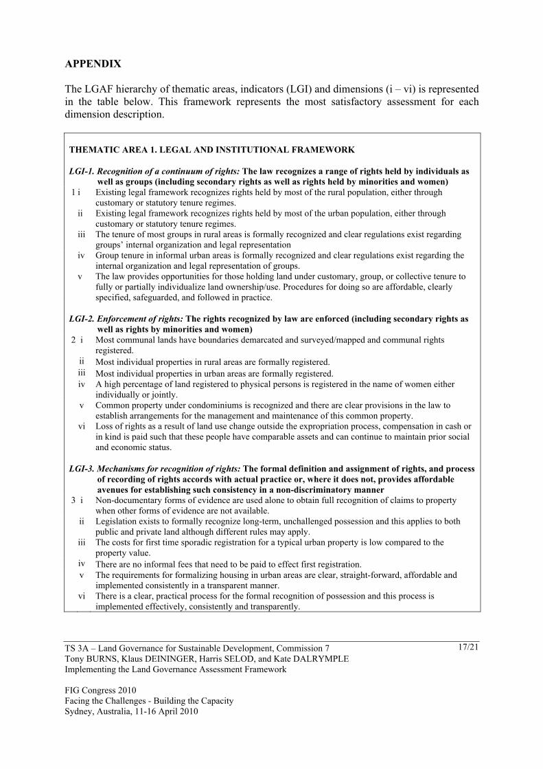
APPENDIX The LGAF hierarchy of thematic areas, indicators (LGI) and dimensions (i – vi) is represented in the table below. This framework represents the most satisfactory assessment for each dimension description.
THEMATIC AREA 1. LEGAL AND INSTITUTIONAL FRAMEWORK
LGI-1. Recognition of a continuum of rights: The law recognizes a range of rights held by individuals as well as groups (including secondary rights as well as rights held by minorities and women)
1 i Existing legal framework recognizes rights held by most of the rural population, either through customary or statutory tenure regimes.
ii Existing legal framework recognizes rights held by most of the urban population, either through
customary or statutory tenure regimes.
iii The tenure of most groups in rural areas is formally recognized and clear regulations exist regarding
groups’ internal organization and legal representation
iv Group tenure in informal urban areas is formally recognized and clear regulations exist regarding the
internal organization and legal representation of groups.
v The law provides opportunities for those holding land under customary, group, or collective tenure to fully or partially individualize land ownership/use. Procedures for doing so are affordable, clearly specified, safeguarded, and followed in practice.
LGI-2. Enforcement of rights: The rights recognized by law are enforced (including secondary rights as well as rights by minorities and women)
2 i Most communal lands have boundaries demarcated and surveyed/mapped and communal rights registered.
ii Most individual properties in rural areas are formally registered. iii Most individual properties in urban areas are formally registered.
iv A high percentage of land registered to physical persons is registered in the name of women either
individually or jointly.
v Common property under condominiums is recognized and there are clear provisions in the law to
establish arrangements for the management and maintenance of this common property.
vi Loss of rights as a result of land use change outside the expropriation process, compensation in cash or in kind is paid such that these people have comparable assets and can continue to maintain prior social and economic status.
LGI-3. Mechanisms for recognition of rights: The formal definition and assignment of rights, and process of recording of rights accords with actual practice or, where it does not, provides affordable avenues for establishing such consistency in a non-discriminatory manner
3 i Non-documentary forms of evidence are used alone to obtain full recognition of claims to property when other forms of evidence are not available.
ii Legislation exists to formally recognize long-term, unchallenged possession and this applies to both
public and private land although different rules may apply.
iii The costs for first time sporadic registration for a typical urban property is low compared to the
property value. iv There are no informal fees that need to be paid to effect first registration.
v The requirements for formalizing housing in urban areas are clear, straight-forward, affordable and
implemented consistently in a transparent manner.
vi There is a clear, practical process for the formal recognition of possession and this process is
implemented effectively, consistently and transparently.
TS 3A – Land Governance for Sustainable Development, Commission 7 Tony BURNS, Klaus DEININGER, Harris SELOD, and Kate DALRYMPLE Implementing the Land Governance Assessment Framework FIG Congress 2010 Facing the Challenges - Building the Capacity Sydney, Australia, 11-16 April 2010
18/21
LGI-4. Restrictions on rights: Land rights are not conditional on adherence to unrealistic standards. 4 i There are a series of regulations regarding urban land use, ownership and transferability that are for the
most part justified on the basis of overall public interest and that are enforced.
ii There are a series of regulations regarding rural land use, ownership and transferability that are for the
most part justified on the basis of overall public interest and that are enforced.
LGI-5. Clarity of mandates and practice: Institutional mandates concerning the regulation and management of the land sector are clearly defined, duplication of responsibilities is avoided and information is shared as needed.
5 i There is a clear separation in the roles of policy formulation, implementation of policy through land management and administration and the arbitration of any disputes that may arise as a result of implementation of policy.
ii The mandated responsibilities exercised by the authorities dealing with land administration issues are
clearly defined and non-overlapping with those of other land sector agencies.
iii Assignment of land-related responsibilities between the different levels of government is clear and non-
overlapping.
iv Information related to rights in land is available to other institutions that need this information at reasonable cost and is readily accessible, largely due to the fact that land information is maintained in a uniform way.
LGI-6. Equity and non-discrimination in the decision-making process: Policies are formulated through a legitimate decision-making process that draws on inputs from all concerned. The legal framework is non-discriminatory and institutions to enforce property rights are equally accessible to all
6 i A comprehensive policy exists or can be inferred by the existing legislation. Land policy decisions that affect sections of the community are based on consultation with those affected and their feedback on the resulting policy is sought and incorporated in the resulting policy.
ii Land policies incorporate equity objectives that are regularly and meaningfully monitored and their
impact on equity issues is compared to that of other policy instruments.
iii Implementation of land policy is costed, expected benefits identified and compared to cost, and there
are a sufficient budget, resources and institutional capacity for implementation.
iv Land institutions report on land policy implementation in a regular, meaningful, and comprehensive
way with reports being publicly accessible.
THEMATIC AREA 2. LAND USE PLANNING, MANAGEMENT, AND TAXATION
LGI-7. Transparency of land use restrictions: Changes in land use and management regulations are made in a transparent fashion and provide significant benefits for society in general rather than just for specific groups.
7 i In urban areas, public input is sought in preparing and amending changes in land use plans and the public responses are explicitly referenced in the report prepared by the public body responsible for preparing the new public plans. This report is publicly accessible.
ii In rural areas, public input is sought in preparing and amending land use plans and the public responses are explicitly referenced in the report prepared by the public body responsible for preparing the new public plans. This report is publicly accessible.
iii Mechanisms to allow the public to capture significant share of the gains from changing land use are
regularly used and applied transparently based on clear regulation.
iv Most land that has had a change in land use assignment in the past 3 years has changed to the destined
use.
TS 3A – Land Governance for Sustainable Development, Commission 7 Tony BURNS, Klaus DEININGER, Harris SELOD, and Kate DALRYMPLE Implementing the Land Governance Assessment Framework FIG Congress 2010 Facing the Challenges - Building the Capacity Sydney, Australia, 11-16 April 2010
19/21
LGI-8. Efficiency in the land use planning process: Land use plans and regulations are justified, effectively implemented, do not drive large parts of the population into informality, and are able to cope with population growth.
8 i In the largest city in the country urban development is controlled effectively by a hierarchy of regional/detailed land use plans that are kept up-to-date.
ii In the four major cities urban development is controlled effectively by a hierarchy of regional/detailed
land use plans that are kept up-to-date.
iii In the largest city in the country, the urban planning process/authority is able to cope with the increasing demand for serviced units/land as evidenced by the fact that almost all new dwellings are formal.
iv Existing requirements for residential plot sizes are met in most plots.
v The share of land set aside for specific use that is used for a non-specified purpose in contravention of
existing regulations is low
LGI-9. Speed and predictability of enforcement of restricted land uses: Development permits are granted promptly and predictably.
9 i Requirements to obtain a building permit are technically justified, affordable, and clearly disseminated. ii All applications for building permits receive a decision in a short period.
LGI-10. Transparency of valuations: Valuations for tax purposes are based on clear principles, applied uniformly, updated regularly, and publicly accessible
10 i The assessment of land/property values for tax purposes is based on market prices with minimal differences between recorded values and market prices across different uses and types of users and valuation rolls are regularly updated.
ii There is a policy that valuation rolls be publicly accessible and this policy is effective for all properties
that are considered for taxation.
LGI-11. Collection efficiency: Resources from land and property taxes are collected and the yield from land taxes exceeds the cost of collection
11 i There are limited exemptions to the payment of land/property taxes, and the exemptions that exist are clearly based on equity or efficiency grounds and applied in a transparent and consistent manner.
ii Most property holders liable for land/property tax are listed on the tax roll. iii Most assessed property taxes are collected.
iv The amount of property taxes collected exceeds the cost of staff in charge of collection by a factor of
more than 5.
THEMATIC AREA 3. MANAGEMENT OF PUBLIC LAND
LGI-12. Identification of public land and clear management: Public land ownership is justified, inventoried, under clear management responsibilities, and relevant information is publicly accessible
12 i Public land ownership is justified by the provision of public goods at the appropriate level of government and such land is managed in a transparent and effective way.
ii The majority of public land is clearly identified on the ground or on maps. iii The management responsibility for different types of public land is unambiguously assigned. iv There are adequate budgets and human resources that ensure responsible management of public lands. v All the information in the public land inventory is accessible to the public. vi Key information for land concessions is recorded and publicly accessible.
LGI-13. Justification and time-efficiency of expropriation processes: The state expropriates land only for overall public interest and this is done efficiently
13 i A minimal amount of land expropriated in the past 3 years is used for private purposes.
ii The majority of land that has been expropriated in the past 3 years has been transferred to its destined
use.
TS 3A – Land Governance for Sustainable Development, Commission 7 Tony BURNS, Klaus DEININGER, Harris SELOD, and Kate DALRYMPLE Implementing the Land Governance Assessment Framework FIG Congress 2010 Facing the Challenges - Building the Capacity Sydney, Australia, 11-16 April 2010
20/21
LGI-14. Transparency and fairness of expropriation procedures: Expropriation procedures are clear and transparent and compensation in kind or at market values is paid fairly and expeditiously
14 i Where property is expropriated, fair compensation, in kind or in cash, is paid so that the displaced households have comparable assets and can continue to maintain prior social and economic status.
ii Fair compensation, in kind or in cash, is paid to all those with rights in expropriated land regardless of
the registration status. iii Most expropriated land owners receive compensation within one year. iv Independent avenues to lodge a complaint against expropriation exist and are easily accessible.
v A first instance decision has been reached for the majority of complaints about expropriation lodged
during the last 3 years.
LGI-15. Transparent process and economic benefit: Transfer of public land to private use follows a clear, transparent, and competitive process and payments are collected and audited.
15 i Most public land disposed of in the past 3 years is through sale or lease through public auction or open tender process.
ii A majority of the total agreed payments are collected from private parties on the lease of public lands.
iii All types of public land are generally divested at market prices in a transparent process irrespective of the investor’s status (e.g. domestic or foreign).
THEMATIC AREA 4. PUBLIC PROVISION OF LAND INFORMATION
LGI-16. Completeness: The land registry provides information on different private tenure categories in a way that is geographically complete and searchable by parcel as well as by right holder and can be obtained expeditiously by all interested parties
16 i Most records for privately held land registered in the registry are readily identifiable in maps in the registry or cadastre.
ii Relevant private encumbrances are recorded consistently and in a reliable fashion and can be verified at
low cost by any interested party.
iii Relevant public restrictions or charges are recorded consistently and in a reliable fashion and can be
verified at a low cost by any interested party. iv The records in the registry can be searched by both right holder name and parcel.
v Copies or extracts of documents recording rights in property can be obtained by anyone who pays the
necessary formal fee, if any.
vi Copies or extracts of documents recording rights in property can generally be obtained within 1 day of
request.
LGI-17. Reliability: Registry information is updated, sufficient to make meaningful inferences on ownership
17 i There are meaningful published service standards, and the registry actively monitors its performance against these standards.
ii Most ownership information in the registry/cadastre is up-to-date.
LGI-18. Cost-effectiveness and sustainability: Land administration services are provided in a cost-effective manner.
18 i The cost for registering a property transfer is minimal compared to the property value. ii The total fees collected by the registry exceed the total registry operating costs.
iii There is significant investment in capital in the system to record rights in land so that the system is
sustainable but still accessible by the poor.
LGI-19. Transparency: Fees are determined and collected in a transparent manner 19 i A clear schedule of fees for different services is publicly accessible and receipts are issued for all
transactions.
TS 3A – Land Governance for Sustainable Development, Commission 7 Tony BURNS, Klaus DEININGER, Harris SELOD, and Kate DALRYMPLE Implementing the Land Governance Assessment Framework FIG Congress 2010 Facing the Challenges - Building the Capacity Sydney, Australia, 11-16 April 2010
21/21
ii Mechanisms to detect and deal with illegal staff behavior exist in all registry offices and all cases are
promptly dealt with.
THEMATIC AREA 5. DISPUTE RESOLUTION AND CONFLICT MANAGEMENT
LGI-20. Assignment of responsibility: Responsibility for conflict management at different levels is clearly assigned, in line with actual practice, relevant bodies are competent in applicable legal matters, and decisions can be appealed against.
20 i Institutions for providing a first instance of conflict resolution are accessible at the local level in the majority of communities.
ii There is an informal or community-based system that resolves disputes in an equitable manner and decisions made by this system have some recognition in the formal judicial or administrative dispute resolution system.
iii There are no parallel avenues for conflict resolution or, if parallel avenues exist, responsibilities are clearly assigned and widely known and explicit rules for shifting from one to the other are in place to minimize the scope for forum shopping.
iv A process and mechanism exist to appeal rulings on land cases at reasonable cost with disputes
resolved in a timely manner.
LGI-21. Low level of pending conflict: The share of land affected by pending conflicts is low and decreasing
21 i Land disputes in the formal court system are low compared to the total number of court cases.
ii A decision in a land-related conflict is reached in the first instance court within 1 year in the majority of
cases. iii Long-standing land conflicts are a small proportion of the total pending land dispute court cases.