implicit book.digital.fv1
DESCRIPTION
GeoTRANSCRIPT

3D implicit modelling
Unearthing
Why implicit modelling? [05] Reducing geological risk [09] Sources of geological modelling uncertainty investigated. What role does the data play? [15] Rapid visualisation and modelling of geological data - transformational lessons at MMG [21] The future of geological modelling [27] Can implicit methods be used to model complex geology? [33] Is implicit modelling reliable enough for use in resource domaining? [37] Validating an implicit model [43] Where is implicit modelling heading? [50]


Why implicit modelling? 05DR RICHARD LANE
Reducing geological risk 09MARC MELKER & PATRICK ‘PJ’ HOLLENBECK
Sources of geological modelling uncertainty investigated. What role does the data play? 15MIKE STEWART
Rapid visualisation and modelling of geological data - transformational lessons at MMG 21ANTHONY REED
The future of geological modelling 27PAUL HODKIEWICZ
Can implicit methods be used to model complex geology? 33LAÉRCIO GUEDES BERTOSSI & GUSTAVO USERO
Is implicit modelling reliable enough for use in resource domaining 37PETER GLEESON
Validating an implicit model 43RON REID
Where is implicit modelling heading? 50
1

Celebrating Leapfrog’s 10 year anniversary
2 Unearthing 3D implicit modelling
Unearthing 3D implicit modelling CEOShaun MaloneyARANZ Geo Limited. The developers of Leapfrog® We are pleased to bring you this insight into implicit modelling. There seems to be no better way to celebrate Leapfrog’s 10 year anniversary in the industry than asking industry experts to unearth ‘implicit modelling’, as it is known today.
This book contains valuable insights, comments and opinions from those experts whose day job brings them into direct contact with the various modelling software packages, tools, methodologies and outputs. I’d like to thank them all for their contribution, which has been provided free of charge and in their own time. We hope that by sharing their experience and knowledge you’ll gain real insight into implicit modelling and its role in business, gain confidence through challenging it, and, most importantly, embrace its capability in your day-to-day decision-making.
It’s been an exciting first 10 years for the Leapfrog software suite and the team at ARANZ Geo. Leapfrog’s implicit modelling science has blazed a trail for others to follow. We’ve gone from being perceived as a maverick cutting-edge niche product to a world class software suite used internationally by thousands of users. Ten years on, we can say with certainty that implicit modelling is here to stay.
Our thanks go to those visionary early adopter geologists who had the foresight to recognise Leapfrog’s potential and who continually provided us with their insights and ideas to help us evolve. Together we’ve started what can only be described as a paradigm shift in the industry.
As well as providing a very useful reference, I hope this book will provoke continued discussion, challenge ideas and inspire learning to further advance implicit modelling techniques and standards into the next decade.
Shaun Maloney
3

Richard Lane spent 15 years researching estimation and modelling problems in optical sciences. This work resulted in over 100 publications in peer-reviewed journals and conferences, and he was a reviewer for the major publications in this field. The chance to be part of a revolutionary change in an industry led him to join ARANZ Geo in 2003, where he leads the company’s development of new implicit modelling algorithms.
DR RICHARD LANE
RESEARCH DIRECTOR
ARANZ GEO
4 Unearthing 3D implicit modelling

Why implicit modelling?Geology is a science rather than an engineering discipline because it models the real world instead of building structures within it. These models evolve continually with the collection of new data and the scientist’s improving understanding of the physical processes that govern the creation of the geological environment.
By contrast, engineers take scientific models and use them as constraints to design and build structures, devices and systems. The difference is important because while geologists require tools that enable them to create and compare possible models quickly and efficiently, engineers need tools with a greater emphasis on precision because they form the basis for precise construction. This difference in requirements is not confined to the earth sciences. The tools used by architects to design building concepts differ significantly from those employed by engineers to specify the final construction.
Given the wide difference between the disciplines of science and engineering, it would be surprising that a single set of tools would suit both scientists and engineers. In mining, the traditional engineering design approach of using sections, plans and elevations to define a structure in 3D is also used to specify natural geological structures. This is in spite of these geological structures almost never being straight and aligned with a set of coordinate axes. The contrast is evident in Figure 1.
WHY IMPLICIT MODELLING 5

Explicit modelling in geological modelling is essentially akin to an engineering drawing process. The modeller defines geological structures such as veins and faults by explicitly drawing them on regularly spaced sections and joining them. The data may be used by the modeller to constrain where they draw, and there may be tools to accelerate the process, but fundamentally it is a process of drawing. This suits the engineering world where an exact definition of a structure is a precursor to its construction.
So why is the engineering approach a problem when modelling geology? Simply because geology doesn’t come in boxes, triangles, straight lines or even sophisticated Bezier curves. All of these are simply ways of representing the geology on a computer. Many of the awkward problems people face when geological modelling are the result of the computer software expecting a geologist to conform to the computer’s world and not the other way around.
Implicit modelling differs in that it relies on an application of rules to transform the input data to produce a model.
This model can then be manipulated and refined, but fundamentally it is generated by computer algorithms directly from a combination of measured data and user interpretation. The modelling still requires a geologist’s insight, but this input is made in the form of trends, stratigraphic sequences and other geologically meaningful terms. This approach is faster, more flexible and fundamentally better suited to making geological models.
The other major advantage of implicit modelling is that the models can be made to always satisfy important geological constraints. For example, it can ensure that the lithological units fill the space under the ground with no gaps and spaces. When the 3D model has this property, any section cut through at any position will always be consistent with other sections. This property is not the case in an explicit model where the sections are created independently and then fitted together to try and create a 3D model. The onus is then on the geologist to essentially do the bookkeeping.
01FIGURE 1: A comparison of engineering and geological structures.
02FIGURE 2: The difference between an explicit and an implicit section. While at first sight they may appear similar, the explicit section (top) is an input used to create the model formed by manually joining contact points, whereas an implicit section (bottom) is an output created by slicing through a 3D model created directly from the data.
6 Unearthing 3D implicit modelling

When the first implicit models were created, they were considered to be lacking detail and were mainly employed in early exploration. However, implicit modelling algorithms have evolved rapidly and now can easily exceed the complexity and level of detail in hand-drawn models. This process of improvement continues, and although there are still some examples where an explicit hand-drawn model produces superior results, these are becoming less and less frequent.
One of the most common difficulties that people find when moving from an explicit to an implicit modelling process is the concept of a model being a set of mathematical functions. They are much more familiar with wireframes, sections and block models. For certain practical problems, these are entirely appropriate. For example, modern computer graphics hardware is optimised to display wireframes, an axially-aligned section may succinctly explain the geology and a block model may map very closely to an open pit mining process.
03FIGURE 3: A complex vein system
In essence, implicit modelling allows geologists to produce useful models quickly and efficiently and then adapt those models to the needs of the end user, be they engineers, managers or investors.
The critical advantage of an implicit model is that it allows the user to answer a simple question: If I went to a particular point under the ground, what would I expect to find based on the data? When we know this at a resolution determined by the data, we can:
• Convert an implicit model into blocks by averaging all the points within a block
• Create wireframes by connecting all the points with the same value
• Create sections by interrogating the model at a defined plane
Today, many people find the increased modelling speed of the implicit modelling process is justified by the benefit of having an up-to-date model that incorporates the latest data. However, another significant benefit is that implicit modelling allows more than one geological interpretation to be considered and maintained. The geological uncertainty is a critical factor in many projects, and it is hard to see how this can be adequately
described using a single model. In future the principal benefit of the current industry change to implicit modelling will be that geological risk can finally be quantified in a usable manner.
Modelling is the process of producing a simplified version of the real world in a form that allows someone to understand the underlying processes and make predictions. The famous mathematical modeller George Box once said:
“All models are wrong, but some are useful.”
WHY IMPLICIT MODELLING 7
PATRICK ‘PJ’ HOLLENBECK
INDEPENDENT CONSULTING GEOLOGIST
Patrick ‘PJ’ Hollenbeck is an Independent Consulting Geologist specialising in computer modelling and resource estimation. He has over 14 years of mining experience, including field work, software support and resource consulting.
MARC MELKER
INDEPENDENT CONSULTING GEOLOGIST
Marc Melker worked as a Senior Consulting Geologist at Newmont Mining Corporation at the time of writing. He is a M.S. graduate of the University of New Mexico and has over 18 years’ experience in resource exploration, modelling and estimation; mining; ore control; quality control; geologic and applied technologic research. He is a Certified Professional Geologist.
8 Unearthing 3D implicit modelling

Patrick Hollenbeck and Marc Melker provide their viewpoints on reducing geological risk.
Reducing geological risk
REDUCING GEOLOGICAL RISK 9

The modern approach of integrating implicit modelling processes into the workflow has not only expedited the first iteration of a model, but has facilitated the construction of multiple versions and refinements of models to test and compare with known data. This can be done in the same time as a single model would have been made with prior methods.
Section-view blindersIn my formative years as a resource geologist, my primary tool for constructing geologic models was the extruded polygon on section. It was the “tried and true” method of modelling within General Mining Packages, and was well-established as providing the user with complete control over the model. There were not usually debates over whether it was a black box or mysterious method, as it was simply drawing polygons to define a body on section and connecting those polygons with triangulated extrusions to form a solid mass to represent geology. Inevitably, a seemingly simple model would take weeks, if not months, of painstaking polygon digitisation to arrive at the end goal of a representative model shape to use. I would seldom attempt to introduce faulting or any additional shape-morphing factors unless substantial time was available to spend fine-tuning the model. In most cases, any complexities were ignored or simplified to the point that the model would flex and undulate like a battered accordion and would only generally make geologic sense. It was my attempt to try to simulate a complex system while still working within the limitations of “section-view blinders,” for which the model would inherently suffer.
The risk of the single modelProject time constraints are a perpetual concern for a consultant and never more so than when building the geologic models that are the basis of all resource estimation work to follow. Typically, new project data needs to be vetted, corrected, modelled, estimated and reported within a 2-3 month window. By the time the raw data has been cleaned up and is ready to use, the remaining time available is a premium asset. If I were to spend multiple weeks or months on a polygonal model, I would have insufficient time to review the model, make refinements or even reasonably understand the deposit as I’ve modelled it before a resource needs to be calculated and reports written. Nuances or additional hypotheses on an area would be overlooked in favour of the first-pass model generated. As such, a polygon-on-section approach with time restrictions cannot avoid the issue of rendering a single model to represent absolute reality for the remaining modelling process moving forward. Clearly this leads to a high degree of risk, as no alternative hypotheses were ever investigated in the course of building the sole model.
Taking a global viewImplicit modelling is able to significantly reduce the degree of “geologic risk” inherent in any model construction by allowing many models to be built in a relatively short time while still viewing the data globally. Complex geometry becomes easily understood if it’s viewed in a global setting, as factors such as fault movement make much more sense when one is able to see the entire relationship. The application of the complex geometry becomes much more practical when the computer is doing most of the
Geologic risk is the subjective measure of the willingness of the modeller to, as the old saying goes, put all of their eggs in one basket. Committing to a single model as “The Truth” is all too often the case in resource consulting and is a result of the prevalence of established polygon-based modelling and estimation practices paired with time limitations on a given consulting project.
REDUCING GEOLOGICAL RISK by Patrick ‘PJ’ Hollenbeck
10 Unearthing 3D implicit modelling

heavy lifting, which is not possible with a polygonal model approach. Likewise, questionable interpretations are quickly identified as the geologist is not trapped in a limited section-view (i.e. “section-view blinders”). A global view allows the geologist to see new modifications in the entire model at once, so inconsistencies and errors can be quickly resolved. Additionally, geostatistical analysis can be performed on multiple models to identify which is statistically the most valid. One has the option of choosing the model with the least amount of waste material in an ore boundary, the best variography results, the most normal distribution of grade values, and so on. By reducing the geologic risk, statistical risk will likewise diminish.
Process of refinementIn practice, I typically build revisions on a theme with the same conceptual model in mind rather than drastically different and mutually-exclusive models. As a model progresses, an early-stage iteration might be considered “usable” (certainly comparable to a typical polygonal-model approach) but with some questions remaining for certain areas. At this point, the existing model can be copied to retain the original, then the copied model will be refined, resulting in a process that is self-preserving. In my modelling routine, I may come up with half a dozen or more model iterations that are copies of copies, each one a modification of the last. For instance, I might have a completely un-faulted model to start, with a second iteration introducing the major faults, a third iteration to include minor faults, and a fourth iteration incorporating dike intrusions. I don’t want to lose the possibility that the
first model was “more” correct, yet I want to be able to test how different hypotheses will affect my model differently. Additionally, implicit modelling software will typically update models automatically when new data is available, meaning that some model iterations will be quickly proven false once a new season of drilling or mapping data is imported into the modelling software, while other modelling iterations will likely carry through and have a degree of validation provided by the appended data. Those remaining models can then be refined and expanded upon with additional models to test again when the next collection of new data is made available.
Channel for discussionThe ability to create multiple models is not only helpful for internal use, but is extremely pragmatic when communicating with a client. Prior to implicit modelling, I would provide the client with rough versions of the single polygonal model, to which they would advise ways to refine that model. Today, when I present a client with a half-dozen iterations of their model, it opens a channel for discussion as to which model should be considered the best, given their knowledge of the field aspects. Often, the client is presented with a hypothesis they hadn’t considered and that may well become a new target for investigation. As a consultant, this ability to contribute to the conversation regarding geologic interpretation, potentially aiding the client in their future endeavours beyond the model estimation, is a value-added benefit I simply couldn’t provide without implicit modelling.
REDUCING GEOLOGICAL RISK 11

The geology model is the basis for virtually all decisions in the resource extraction industry. It frames the calculation of resources, mine planning, recovery and, ultimately, the profitability of any project. Every downstream decision is at least as wrong as the geology model itself, so starting with the best (or least wrong) model is a critical precursor for any resource extraction decision.
REDUCING GEOLOGICAL RISK by Marc Melker
A geology model can be thought of as a single realisation of geologic interpretation in a cloud of possible interpretations inherent within the sample data set. Sample datasets are orders of magnitude smaller than the volume ultimately represented by a model and, therefore, the sample dataset is permissive of many possible interpretations. Furthermore, most geologic sample data are themselves based on interpretation during the logging phase. These two factors demonstrate that more than one model outcome is possible and, therefore, more than one should be constructed and its merits evaluated before settling on a “final” interpretation. In fact, a final interpretation may be presented to downstream users with error bars when more than one model is evaluated and this frames a basic understanding of the risk involved.
This is the ideal situation, where the evaluation of several models allows understanding of risk and likelihood of success. However, up to the present day very few resource projects have benefited from this approach at the geology modelling phase. It is common in business planning, where dollar values are applied to resource estimates and expected economic outcomes are calculated. But the connection between the economic evaluation and the underlying assumptions of the geology model are usually poorly understood. The geology model is usually taken as ground truth, regardless of how well it was constructed or its risks understood. If the geology model, the very basis of the economic evaluation, is insufficiently characterised, the risk of the resulting business decision is an unknown for the decision makers.
Two-dimensional processThe standard construction of a geology model typically relies on the sectional construction of lines and polygons that represent important geologic features. These are either drawn by hand on paper sections or on a computer screen. These two-dimensional representations then get converted to 3D simply by tying the successive 2D slices together, like stacking slices of bread to make a loaf. It is, however, a fundamentally two-dimensional process. The important geologic features may change from deposit to deposit or commodity type, but the basic method has, up until very recently, been the same. That is, laboriously drawing lines, then erasing them only to redraw them again with the addition of more data. It takes time and usually only one model will be produced because it is simply too time-intensive to draw a set of lines that also make sense in 3D, much less geologically or that can convey risk. The shapes of geological objects are frequently much more complicated than stacking slices of bread to make a loaf.
12 Unearthing 3D implicit modelling

Enter implicit modellingFaster computers and advanced software now allow a skilled driver to frame a series of data handling steps that generate three-dimensional models. The heavy lifting traditionally undertaken by a geologist drawing hundreds of lines is now completed in a fraction of the time and in 3D by fast processors and efficient mathematical algorithms. Implicit modelling allows a geologist to focus on the geology and examine the possible outcomes of the data at hand using repeatable, objective algorithms rather than spending all their time drawing lines only to complete one possible subjective version.
The precipice of changeSo having framed the situation above, the industry is at the precipice of change. The single-model sectional approach is still a default operating procedure in many sectors, but implicit techniques are gaining traction. The attraction of fostering multiple hypotheses and having time to examine them fully in three dimensions and not just in the mind’s eye is quickly approaching critical mass.
Obstacle to acceptanceYet it is the speed that geologists and managers sometimes worry about, that without going through and painstakingly drawing each line on every section somehow there is less intimacy with the data. The speed of implicit modelling can feel a bit like a black box where the geologist has lost control. This is a fundamental obstacle to wider acceptance, but it will fade with familiarity and training. The truth is
speed is the great advantage of implicit modelling; one can arrive at the wrong answer very quickly. The advantage is that the first model, or maybe even the second and third can be quickly dismissed as the important details for a particular dataset and the geology it represents are realised. Error and misunderstanding are made obvious to the modeller through the un-geologic shapes that are produced without proper geologic conditioning.
Driving improvementImplicit modelling software is just another tool in the geologist’s toolbox, and like any other tool it must be properly used and applied to the appropriate situation. It is, however, fundamentally different: the geologist must rely on well-constructed and clean datasets. The filtering and vetting of data on a particular section that would traditionally be controlled in the geologist’s head now must lie inherent in the dataset. Poor logging techniques and sloppy standards are made obvious to the simplicity and unbiased eye of a computer algorithm. Not only will implicit modelling help geologists examine more geologic possibilities faster, it will necessarily drive improvement in data management and logging practices and put appropriate focus on the data that drives so many business decisions.
Modelling speed and a focus on the data will drive an important understanding of geologic risk and uncertainty that is so far lacking in geologic models. Fundamentally, we will be able to quantify risk and with the easy days of mining behind us, understanding the geologic uncertainty of resource extraction projects in the mining industry is critical to our continued success.
REDUCING GEOLOGICAL RISK 13

MIKE STEWART
SENIOR PRINCIPAL CONSULTANT
QG
Mike Stewart is Senior Principal Consultant at QG Pty Ltd. As a consulting geologist and geostatistician, he provides the full range of resource estimation, reconciliation, grade control, audit, due diligence and business consultancy. He has applied his skills in a diverse range of open-pit and underground mining environments. His areas of specialist expertise include the numerical modelling of resources; the classification and reporting of resources under JORC and NI 43-101; and sampling and management of data quality, including training and mentoring in this highly specialised area.
14 Unearthing 3D implicit modelling
Sources of geological modelling uncertainty investigated What role does the data play?
One of the primary tasks of applied geologists is to build predictive models. These vary enormously in their scope and application, from grand theories to explain the current arrangement of the continents, to the generation of exploration models for targeting drilling, through to predicting whether the next truckload mined from an underground development heading should be sent to the mill or the waste dump.
The types of phenomena we deal with in geology (lithological contacts, margins of intrusive bodies, element grades, etc.) are variable, sometimes highly so, and the information available is generally sparse. There will inevitably be differences between the predictions that can be made from the data (via geological models) and reality. Moreover, there are multiple possible geological models that will honour the known facts.
“ Variability is a phenomenon in the physical world to be measured, analysed and where appropriate explained. By contrast, uncertainty is an aspect of knowledge.”
SIR DAVID COX.
SOURCES OF GEOLOGICAL MODELLING UNCERTAINTY INVESTIGATED 15

GEOLOGICAL MODELS RELY ON DIFFERENT TYPES OF INPUT:
• Hard data from drilling, mapping, underground exposure, etc. in the form of:
• Direct physical measurement of rock properties (grades, density, UCS)
• Observations of physical attributes (lithology, colour, grainsize)
• Identification of location and orientation of boundaries/contacts
• Soft data from indirect measurement (e.g. geophysical response)
• Interpretation, i.e. hypotheses put forward to explain the available data
The relative importance of interpretation versus hard and soft data varies, but in general, the more specific and operational the use of a model, the more the model will rely on hard data rather than abstract concepts or interpretation. However, even in the best informed types of model used in mining geology (e.g. grade control block models), the quantity of hard data available is very small. A typical metalliferous grade control pattern will only physically sample between 0.1% and 0.01% of the deposit. Early stage models (e.g. a resource model used in a feasibility study) may have two or more orders of magnitude less physical data available.
Implicit modellingImplicit modelling is an approach to spatial modelling in which the distribution of a target variable is described by a unique mathematical function that is derived directly from the underlying data and from high level parametric controls specified by the user. This modelling approach may be applied to discrete variables such as lithology (where it may be used to create geometric models of lithological units/contacts), to continuous variables such as geochemical grades to model the distribution of grades at points or over block volumes, or to binary indicators of continuous variables.
Implicit modelling will create a unique solution from any set of input data and given set of input parameters (either a geometry or a grade interpolant). Changing the modelling parameters will affect the output, and the choice of input parameters is clearly an important consideration in matching the character of the output model to the phenomenon we are attempting to describe. However, in many situations, the hard data available will simply be insufficient to directly support creation of a model that is geologically plausible or reasonable.
16 Unearthing 3D implicit modelling

Hypothesised and interpreted data So how do we make the output of a data driven model look like our interpreted understanding of the geological phenomenon we are modelling? The solution is to add ‘hypothesised data’ to the model until the model output adequately describes our ‘geological interpretation’.
In the Leapfrog® implementation of implicit modelling, three different types of hypothesised data may be added to geometric models - structural disks (which identify the location and orientation of a geological contact), polylines (which identify the location and facing direction of a contact at polyline node points), and curved polylines (same as polylines but with more points, and to which orientations can be added). In grade interpolation models, polyline contours may be added at a given grade threshold - these data effectively act as assay information.
In essence, this process of ‘making up’ data to force a geological interpretation into the model is exactly the same in implicit modelling as it is in more traditional CAD-based sectional approaches to modelling. In the explicit approach, the user ‘draws’ an interpretation that explains the data (usually using a sectional polygon), which is then triangulated into a wireframe. The polygon mixes both hard data points (drillhole contact locations) and the interpreted locations. The resultant model (triangulation) may explain the data but is not derived solely from the hard data as it includes the interpreted locations. If the data or interpretive concept changes (e.g. new hard data are added), the explicitly drawn inputs need to be modified and the process used to turn these into a valid closed volume repeated.
One of the clear advantages of implicit modelling is that there is separation between the hard data and the user-created hypothesised data. If new drilling information is added to the hard data set, it is immediately incorporated into the model. The algorithm will always produce a result. This resultant model can then be examined to decide how well the previous hypothesis explains new hard data. If the hypothesis is robust (i.e. the new data confirms the interpretation), then no change will be required. Otherwise, the geological interpretation will need to be changed and/or the modelling parameters and hypothesised data modified accordingly.
This incremental approach to modelling is actually very well aligned with the scientific method. Geological models (including geometry and grade models) are scientific models: they represent hypotheses and ideas that summarise and explain the available information (hard data). Before a new drillhole is drilled, the model provides a prediction of what will be found, and when a hole is drilled, it directly tests the predictive power of the model.
How do we judge whether a model is ‘good’?A good model is one that is ‘fit for purpose’, but how do we define this?
In general terms, ‘fit for purpose’ means that the model meets or exceeds the needs of the user. That, of, course requires expressing what those needs are, which is not always straightforward, and often there are multiple, conflicting needs. In the case of predictive models, ‘fit for purpose’ generally means that the prediction lies within an acceptable tolerance of reality. Clearly, when the prediction is to be used for decision making, less difference is better than more, i.e. when there is less uncertainty in the model.
In the case of a numeric model of grades, ‘fit for purpose’ is a fairly straightforward concept to both define and quantify, e.g. that the predicted grade of copper in a grade control pattern will be within +/- 5% of the reconciled mill grade 90% of the time.
But in geological models represented by geometric shapes, this is a more difficult concept to express. The purposes of creating a model may be manifold – from illustration of an exploration concept used for planning a drill program, to creating the deposit scale interpretation underpinning resource estimates, to defining a single domain volume within which to estimate the above mentioned copper grades. These cases clearly lie along a spectrum: from a situation where hard data input is low and role of parametric choices and interpretive input is high, through to a situation where the quantity of hard data is high, interpretive possibilities are low and where parametric choices have little influence on the output.
Clearly data is a critical determinant of model quality; but equally clearly, the choice of modelling approach used (e.g. implicit versus explicit), choice of model parameter and choices of interpretation are also critical in determining the resultant model, and thus affect how ‘good’ that model is.
Perhaps a more useful approach to considering the ‘quality’ of a model is to consider all of the possible sources of uncertainty that may affect a model, and the relative contribution these make to overall uncertainty.
SOURCES OF GEOLOGICAL MODELLING UNCERTAINTY INVESTIGATED 17

SOURCES OF UNCERTAINTY AFFECTING THE ‘QUALITY’ OF IMPLICIT MODELS:SOURCE CAUSE DESCRIPTION COMMENTS
Intrinsic variability
Variability of the phenomenon of interest at all scales from sample support, to block support, to domain.
Magnitude depends on the phenomena itself and the scale of measurement and estimation. For some phenomena (e.g. precious metal grades) this may be high, for some variables (e.g. seam thickness) low.
Physical data errors
LOCATION Measurement errors in collar and downhole survey measurements, errors in markup, etc.
Magnitude of error depends on the capability of the instruments used - this should be appropriate for the requirements of the job.
LOGGING (SUBJECTIVE) Inconsistency in logging, mis-identification.
Logging is a subjective process. In the future, it is likely that much logging will be replaced by quantitative measurement.
SAMPLING AND ANALYTICAL ERRORS
Primary sample recovery, sampling errors during sample preparation, analytical errors.
Must be actively managed and quantified.
MISTAKES Errors in identification, recording, transcribing, retrieving, attribution. For example, sample swapping, wrong collar.
Errors of this type commonly result in RADICAL errors in models. Frequently the only way to detect such errors is by cognitive processes. Such errors CAN be eliminated. Doing so should be a major focus of data quality management.
Data adequacy SAMPLE SPACING, DISTRIBUTION AND ORIENTATION
Orientation of drilling with respect to key structures, sample spacing relative to volume of interest (SMU), spacing relative to important geological features/grade distribution.
May not be known until after the fact. Often decided by comparison with analogue deposits. High value in obtaining close spaced data at early stages.
OBSERVATION BIASES, KNOWLEDGE GAPS
Whether relevant data is recorded.
As above, relevance may only become clear after time.
Geological interpretation
APTITUDE AND EXPERIENCE OF GEOLOGIST
The ability to create coherent explanations from sparse observations is the key differentiating skill that geologists bring to the minerals industry. The magnitude of uncertainty due to interpretation may be large.
COGNITIVE BIASES AND HEURISTIC ERRORS
Representativeness, anchoring, availability, concreteness, proximity, escalation of commitment.
This is a very real source of risk to the mining industry. Risk may be mitigated by fostering active contemplation of alternatives (e.g. by external input) and adequate resourcing.
Geometric modelling
CHOICE OF MODEL Intrusion vs vein vs contact surface, choice of drift model, global versus structural trend.
There is no objective method for guiding these choices. The decision is usually a pragmatic assessment of which choices produce the best looking results.
CHOICE OF PARAMETERS Compositing rules, anisotropy ratio, orientation of anisotropy, range of continuity etc.
You would generally expect these choices to be at least partly influenced by the data. In praxi, the same pragmatism as described above applies.
Grade estimation
CHOICE OF DOMAIN TO ESTIMATE
A subjective decision guided by the patterns observed in data, the notion of statistical homogeneity, and scale (splitting versus lumping).
CHOICE OF PARAMETERS. Compositing rules, nugget/range of continuity mode, anisotropy orientation and ratio. Choice of drift model.
These choices should be at least partly influenced by the data. In praxi, the same pragmatism as described above applies.

ANTHONY REED
3D STRUCTURAL GEOLOGIST/INFORMATION GEOLOGIST
MMG
Anthony Reed is the current Lead of Implicit Modelling at MMG. He runs in-house training for both Leapfrog Mining and Leapfrog Geo software. He also runs MMG’s implicit modelling workflows, applying structural geology to the deposit modelling process. He is also heavily involved in GIS data analysis and management, including geophysics, geochemistry, satellite imagery and geological mapping.
20 Unearthing 3D implicit modelling
The rapid development of a 3D model has been a goal in MMG’s exploration programs to speed up the decision making process by exponentially increasing the rate and breadth of the data consumption by the geologist. The ease and speed at which a geological model can be built has far-reaching implications in the exploration process, as it means the greater part of the workload can be directed at formulating and testing geological hypotheses, and thus generating meaningful targeting criteria for further success.
There is increasing pressure throughout the mining industry to produce results using fewer resources. In terms of modelling, this translates directly to less time generating accurate and meaningful products. In this climate, an explicit modelling approach can very easily lead to a lack of detail in a depositional model. Where consultants are used for producing explicit models, a culture of external expertise is fostered, where very few in-house geologists study the resulting model in any detail. Using an intuitive implicit geological modelling package, such as Leapfrog®, has allowed MMG to expand the modelling expertise, with many exploration geologists taking on their own projects at varied levels of complexity and adding value with relatively little effort or time investment.
We have found that using Leapfrog for implicit modelling has resulted in an increase in the speed of the modelling process by an order of magnitude for many geological scenarios. The generation of simple objects has never been easier or more accessible. Directly using raw data, which has previously proven tedious at best, is now streamlined to the point of being transformational for exploration projects.
3D modelling is still in its infancy at MMG Exploration. The generation of solid volumes is handled by the resource department who use explicit methods in order to maintain a standard across the organisation. While Exploration has started modelling some solid volumes implicitly, the real value for us has been in the use of Leapfrog Geo and Mining earlier in the process. Ideas are easily drawn from the modelling before it is regarded as complete.
We are developing workflows that promote positive feedback loops in implicit modelling and geological understanding, which is moving us towards our vision of ‘Every geologist using 3D every day’.
Rapid visualisation and modelling of geological data - transformational lessons at MMG
RAPID VISUALISATION AND MODELLING OF GEOLOGICAL DATA - TRANSFORMATIONAL LESSONS AT MMG 21

The value of fast and intuitive data visualisation and validationSimple 3D data visualisation is an incredibly valuable tool for geologists by making complex trends instantly recognisable (Figure 1). Many explicit modelling environments require significant training and data manipulation in order to display meaningful information. Leapfrog Geo has developed interfaces that allow large and complex datasets to be inspected and interpreted using intuitive, fast, and easy-to-learn tools. This has resulted in a far wider range of geologists gaining the confidence to push their understanding into a 3D environment, generating meaningful interpretation that can be shared with peers.
In any model, data validation is a key step to a robust final product. However, as it is often tedious, validation is sometimes completed with less rigour than it should be. Many 3D environments require most raw data to be validated manually or with only partial automation within a database or spreadsheet, applying Boolean rules. This approach cannot guarantee an error free dataset and can be days of work to simply view drillholes in 3D. Common issues include drillhole collars floating in mid-air (Figure 2), subtle survey errors, and irregularity in assay values that can be missed in a normal rule-based validation as thresholds are often not representative of all situations within a project. Leapfrog software takes a different approach, where validation is conducted within the 3D environment. This allows many data issues to be detected and fixed visually by geologists with very little 3D experience whilst simultaneously gaining an understanding of why the validation process is so important. This gives geologists a greater sense of data ownership, feeding into better collection practices, more confidence in the final products generated from the modelling process, and improved buy-in and involvement from all stakeholders.
Interpretation directly within the modelling environmentThe speed of the implicit processing offered in Leapfrog Geo has allowed geologists at MMG to conduct sectional interpretation with greater accuracy. While ‘pencil and paper’ interpretations still provide a certain element of freedom not yet integrated into scientific software, the ability to flick between variables, downhole logging fields, and geochemical calculations directly from
02FIGURE 2: Drillhole collars before and after a visual comparison in 3D with an accurate DEM. Database errors such as these are not picked up in an automated validation process.
01FIGURE 1: NEIC Earthquake Database displayed in Leapfrog Geo after a spherical transformation. A fast, easy interface is critical to allowing an increase in the number of geologists able to conduct their own studies.
22 Unearthing 3D implicit modelling

ioGAS has proven to be enough incentive to conduct 2D and 3D interpretation directly within the 3D view. An implicit modelling environment comes to the fore with the ability to instantly propagate the interpretation from the previous sectional work onto the current area of interest, and while useful for regularly spaced and oriented interpretation, this becomes an essential tool if using perpendicular, oblique, or inclined sections, where conducting such a task on paper has proven inaccurate on many projects. The task has become iterative, where ideas are passed back and forth across datasets, areas, orientations and geologists, resulting in a far more robust interpretation than would otherwise be accomplished.
Speed of modelling solid volumes The implicit approach has proved to be far more efficient than modelling explicitly in many situations. A particularly good case study at MMG is that of a stratiform deposit where a requirement was given to maintain a minimum unit thickness while honouring all available intersection points. Initial modelling was done explicitly with four weeks spent manually adjusting surfaces to align with requirements (unsuccessfully). ARANZ Geo released Leapfrog Geo’s stratigraphic sequence object type at this time, and the model was redone in less than a day (Figure 3). Further refinement was also undertaken due to errant assays and incorrect drillhole logging that could not be quantified or readily detected with an explicit approach.
Radial basis functions: mapping the quick winsThe use of RBF grade interpolants has become a staple of MMG’s exploration processes. Models can now be used at the initial investigation phase of a project, rather than the traditional approach of using them towards the end, after most interpretation had been completed.
Generating new ideasFor a new advanced project, an initial geometrical study of the distribution of grade is undertaken with no bias (Figure 4), allowing the RBF interpolant to simply model the strongest natural trends in the data. Often the results of this first step offers completely new ideas to the geologist and hypotheses on ore grade control can be formulated immediately. Successive refinement using observed trends as controls, form an interative process where controlling structures are retained and refined, and data biases are recognised and removed.
03FIGURE 3: The stratigraphic model object provides the critical combination of continuous strata while incorporating pierce points.
04FIGURE 4: Initial RBF interpolant without bias using a linear variogram. Clearly the primary trends of the deposit are visible, and an initial estimate of the magnitude of the deposit is possible.
RAPID VISUALISATION AND MODELLING OF GEOLOGICAL DATA - TRANSFORMATIONAL LESSONS AT MMG 23

CommunicationThe communication implications at this stage are also major, with sometimes only a few minutes of work resulting in a product that can be shared amongst the group, with the majority of the overarching geometry clearly visible.
Driving decisionsWe use Leapfrog to effectively understand the primary properties of the deposit, possibly driving a go/no-go decision, or as a catalyst to drive further work in a targeted way. In an exploration department where so many deposits require review in a short timeframe, gaining this information and having the ability to compare our own first pass interpretation with the listed resource figures has proven invaluable.
When more than one commodity or element is required to either understand or delineate the deposit, using the same set of controls may or may not give a good representation of the primary features, giving an opportunity to pick multiple generations of mineralisation or alteration.
MMG is bringing structural geology back from being a specialist field (as often treated by the mining industry) and making it mainstream. Structural geology is heavily ingrained in the implicit modelling process, where geometrical relationships are built using overprinting rules and anisotropic trends (Figure 5). To tie any observed trends into a robust geological understanding, further fieldwork is needed for validation. The 3D geological model is no longer an end product, but part of an iterative process that undergoes rigorous testing. With the ability to easily add new data as it is acquired, implicit models have become dynamic objects that are generated to answer scientific questions rather than to be a ‘complete’ representation of a deposit. (Figure 6).
06FIGURE 6: Mineral modes, vein abundances, granular or grouped stratigraphic packages can all be quickly interpolated with an RBF to understand gross geometries, structural complexity and important relationships.
05FIGURE 5: Surfacing with a volume points function (dynamically converting a subset of text based logging into a cloud of distance based values) is an extremely fast method to understand the distribution and geometry of logged geology. This method can save an exorbitant amount of time in comparison to a purely explicit method. RBF interpolants provide an unbiased view of geometry that commonly provide further insight that is absent in mapping or logging.
24 Unearthing 3D implicit modelling

The implicit interpolation of structural surfaces is an essential part of MMG’s workflow (Figure 7), where structural measurement data are propagated throughout a defined space, and form surfaces are generated at defined intervals. This has proven an essential exercise on many projects to gain a quick interpretation of regional geometry where there is little or no sub-surface data, where such critical elements such as depth of prospective horizons can be extracted. Formline mapping in 2D is an underutilised (and under acquired) dataset that provides the most significant information about geometry, and having the ability to instantly generate the equivalent surfaces in 3D has encouraged geologists to inspect their structural data more efficiently than other practices have allowed. Should a deposit be stratiform, a structural form surface is the ideal input for a heterogeneous bias.
Spatial geochemistry Geochemistry has, until recently, been relatively inaccessible with geochemical classification relying on the specific skills of a geochemist who will likely remain one of a handful of people to fully utilise the findings of their study. The ioGAS link has now made Geochemistry far more accessible to other geologists. At MMG, we have found that the software partnership has acted as a gateway to encourage geologists to venture out of their comfort zone and add value to their study. Those already familiar with Leapfrog find that the ability to answer geochemical questions in real-time a good reason to begin using ioGAS in earnest, while Geochemists and those familiar with ioGAS have effectively used Leapfrog to add a far more detailed spatial element to their work (Figure 8), allowing a comparison with geophysical datasets and other modelled objects.
Rapid implicit processes lead to better decisionsAt MMG, working with an implicit modelling package that combines an easy-to-use and easy-to-learn interface, a rapid modelling engine, partnerships with other leading software and intuitive modelling methods have not only increased efficiency, but have caused a real expansion of skillsets for our field geologists, with structural geology, geochemistry, geophysics, and mineralisation characteristics becoming increasingly more accessible. The ability to experiment with, combine, and interpret data quickly allows far more time for us to be geologists, mapping the distribution of complex relationships, testing series of hypotheses, focussing effort on increasing critical ore-body knowledge elements, and ultimately drilling the best targets.
07FIGURE 7: Structural form surface interpolants are essential in tracing stratiform deposits where data is sparse.
08FIGURE 8: Alteration domains modelled from ratios calculated in ioGAS, observed and then modelled using an RBF interpolant in Leapfrog Geo.
RAPID VISUALISATION AND MODELLING OF GEOLOGICAL DATA - TRANSFORMATIONAL LESSONS AT MMG 25

PAUL HODKIEWICZ
SENIOR MANAGER TECHNOLOGY DEVELOPMENT
BHP BILLITON & ADJUNCT RESEARCH FELLOW, Centre for Exploration Targeting, The University of Western Australia
Paul Hodkiewicz is Senior Manager Technology Development, BHP Billiton. Paul worked for ten years as a mine and exploration geologist in Nevada and Indonesia before completing a PhD at the University of Western Australia. After this, he worked for SRK Consulting in Perth as a Senior and Principal Consultant and Director. His current role involves assessment of new technology and innovation across the mining value chain. He has over 25 years of international experience, with expertise in resource evaluation, technology development, structural geology and 3D geological modelling.
26 Unearthing 3D implicit modelling

One of the biggest gaps in mining-industry geoscience is between our understanding of ore deposit formation and the direct application of this understanding in resource estimation. We have made significant advances in both areas over the past several decades. For example, we now have a better understanding of processes of mineralisation associated with interactions between hydrothermal fluids and host rocks due to advanced imaging and analytical methods for rocks and minerals across scales (microscopic to macroscopic).
Regarding resource estimation, advanced geostatistical methods combined with improved hardware and software capability allows rapid processing and interpolation of huge amounts of drillhole data. The problem is that there is sometimes a significant lack of communication and interaction between these two very distinct disciplines – geoscience and geostatistics - which can result in reduced confidence in resource classification and, sometimes, poor business decisions. This is the opportunity and the future of geological modelling.
Mineral systems and mineral resources
The future of geological modelling
THE FUTURE OF GEOLOGICAL MODELLING 27

Ore deposits are concentrations of chemical elements that result from a combination of natural processes that transport, focus and deliver the elements from a source area, where they may be widely dispersed, to the deposit location. This entire process can be described as a mineral system, which includes a source area, mineralising fluids, fluid pathways, an energy source to drive fluid flow along the pathways, chemical and physical processes at the deposit site that precipitate minerals of interest, and, finally, a fluid outflow zone. The mineral system approach originally came from the oil and gas industry, where an understanding of the entire source-pathway-reservoir/trap system is critical for focusing expensive exploration efforts. The mineral system approach has been used successfully in mining industry geoscience and exploration for decades.
With recent advances in geological modelling software, across a range of scales, there is now an opportunity to include mineral system components in the deposit modelling workflow. For example, a better understanding
of fluid pathways (usually structures) and fluid-rock interactions, highlight the shape and continuity of high-grade domains as well as the boundaries between high-grade, low-grade and waste domains.
Consistent application of geological rulesAn important component of advanced implicit modelling software is the ability to include geological rules and timing relationships as constraints. This includes cross-cutting relationships between faults and other structural features, as well as the nature of contacts between geological units and whether they are, for example, depositional, conformable, erosional or intrusion-related. Applying these relationships consistently, where they are well understood, is critical to building a geologically valid and consistent model. It is also important to remember that many ore deposits, especially the larger and/or higher-grade ones, exist because of complex geology. Building valid models of them can be a significant challenge compared to district or
01FIGURE 1: Example of complex geological model built with implicit modelling workflow that honours geological rules and timing relationships between units.
28 Unearthing 3D implicit modelling

regional-scale models where these complex relationships are not always well expressed. Modelling software that includes intuitive and simple-to-use tools for applying geological rules and relationships will, hopefully, become the industry standard in the near future to ensure that deposit models used for resource estimation honour our understanding of complex geology in three dimensions (Figure 1).
Another significant advantage of advanced implicit modelling software is the ability to rapidly build and continuously test a range of geological interpretations. This is important for resource estimation and evaluation because it will provide the capability to build multiple geologically valid scenarios from the same dataset, ranging from pessimistic to optimistic interpretations of continuity between drillholes. In mining, this will improve our understanding of uncertainty and reduce our reliance on a single resource and reserve model for planning and strategic decisions. This will also bring more science into the modelling process because geologists can continuously build and test multiple working hypotheses, a fundamental scientific principle, with more drilling.
Implicit modelling used for resource estimationThe main advantage of implicit modelling is that it uses mathematical interpolants to build surfaces between known points in drillholes, rather than ‘explicit’ or manual construction of these surfaces with points and polylines. In some modelling software, the interpolants are mathematically equivalent to kriging, which is one of the best known and consistently used linear geostatistical interpolation methods. As a result, there is now the opportunity to use the interpolants that generate the geological domains to also do the grade estimation, which would vastly simplify and integrate the geological and geostatistical modelling workflows. As mentioned in the introduction, not only are the disciplines (geoscience and geostatistics) traditionally very different, but the software packages used in both stages of the modelling workflow are equally distinct and siloed. We can now potentially combine them into a seamless workflow in the same modelling package. This would provide good fit-for-purpose results and allow for more geological controls (i.e., an understanding of geological and structural timing relationships) to be used in the estimation workflow and final block model.
Bringing more geology into grade control modelsAt the grade control stage of mining, we have the most geological information about an ore body and usually the least amount of time to make decisions about the boundaries between ore and waste. Poor decisions at this stage, about where to dig and where to ship material, can be very costly and produce poor reconciliation results. At a recent mining geology conference, a world-renowned geostatistician stated the following:
“Increasingly, reconciliation issues are now found to be related to a lack of orebody knowledge in terms of location of the geometric limits of ore, and inadequate understanding of the irregularities of contacts and the ability of mining to follow them.”
This concern is exactly related to the knowledge gap between geology and geostatistics. The power of implicit modelling software to rapidly build and update grade control models, with geological rules intact, can bridge this gap.
THE FUTURE OF GEOLOGICAL MODELLING 29

02FIGURE 2: Plan view of open pit with grade control blocks, which result in angular and unrealistic dig lines.
03FIGURE 3: Plan view of open pit with grade control contour lines following structural trends.
30 Unearthing 3D implicit modelling
For example, traditional grade control dig lines are generally straight lines with sharp corners around block boundaries (Figure 2). These are commonly constructed using only the grade control data from a single bench, without using data from overlying benches, or deeper resource drilling. With the use of structural trends in implicit modelling (which mimic structural pathways for ore fluids) we can now rapidly build more realistic grade control models (Figure 3) using all available data above and below that particular bench. The resulting dig lines look like naturally occurring grade contours and more like what you would expect to see as the result of ore fluids flowing through host rocks. Also, with more GPS-guided and automated mining equipment in the pit, we will have the ability to follow these more irregular and curved contours. In grade control, there is the added challenge of material movement during blasting, but that is a topic for another paper.
Implicit modelling for geoscience training: from classroom to resourceThe most critical component of any geological modelling exercise is that geoscientists have the appropriate knowledge and training to build complex and multi-discipline resource models that can unlock value and benefits for their company, the industry and society as a whole.
SOME OF THE NEW SPECIALIST SKILLS REQUIRED BY GEOSCIENTISTS WILL INCLUDE CAPABILITY IN:
• Down hole geophysical tools and sensors
• Real-time sample analysis and systems (e.g. laser induced breakdown spectroscopy, portable x-ray fluorescence and x-ray diffraction)
• Hyperspectral systems for scanning drill samples and mine faces
• Monitor-while-drilling and ‘smart bit’ systems
• Automated drill rigs and associated equipment
• Data integration and analytics
Of course, fundamental geological understanding will always be the most important skill, so that the data and outputs from these new systems are used to build geologically valid models of ore deposits. The only way to get maximum benefit from this flood of real-time geoscience data will be with implicit modelling systems.
It will also be important that geoscientists in the mining industry develop multi-discipline skills to better understand the requirements of all technical disciplines and downstream customers of their resource models in the mining value chain. This is an opportunity for industry to work with service providers and universities to develop new training programs and facilities to prepare new professionals and undergraduates. This will help to attract and retain the best young geoscientists and showcase mining as a sophisticated, high-tech industry that values and drives innovation and technology development.
The link between geoscience and geostatistics is understanding the 3D distribution of a wide range of elements, minerals and in-situ rock quality data in an ore body and estimating their value across a range of interpretations and scenarios. Models and scenarios that are easy to build and update are fundamental in helping geoscientists to communicate this multi-discipline understanding more widely. This is the future of geological modelling: implicit modelling workflows that honour geological rules will result in a better understanding of uncertainty, opportunities and risks and will enable ore bodies to be mined more efficiently, more environmentally responsibly and more safely.
THE FUTURE OF GEOLOGICAL MODELLING 31

LAÉRCIO GUEDES BERTOSSI
RESOURCE GEOLOGIST
PREVIOUSLY WITH VOTORANTIM
Laércio is a Resource Geologist with more than 8 years’ experience. Responsible for geological modelling and mineral resources evaluation in projects in Brazil and Canada, Laércio has worked with a several commodities (nickel, zinc, lead, aluminium and limestone).
GUSTAVO USERO
RESOURCE GEOLOGIST
PREVIOUSLY WITH VOTORANTIM
Gustavo Usero began his career as a Resource Geologist at Votorantim Metais. He holds a Bachelor’s Degree in Geology from Universidade de São Paulo – Brazil. He started his Resource Geologist career at Votorantim Metais, where he was responsible for performing geological modelling (mainly implicit modelling) and estimation of green field and brown field mineral exploration projects. In particular, he was responsible for the long-term geological model and estimation of Niquelândia lateritic nickel mine.
32 Unearthing 3D implicit modelling

HOW VOTORANTIM USED LEAPFROG TO MODEL A COMPLEX NICKEL DEPOSITCOMPANY: Votorantim Metais (a multinational Brazilian company which works with base metals)
PROJECT: A lateritic, mafic-ultramafic nickel deposit located in Niquelândia, 300Km north of Brasilia in Brazil. The open pit mine produces nickel carbonate using a hybrid pyro-hydrometallurgical process. The deposit is 26 km (N-S) by 6 km (W-E) drilled at a 25x25m space.
DATA: Approximately 372,000 metres of drilled cores
What was the problem?Until 2011, Voltorantim Metais used traditional modelling methods (explicit modelling) to construct and update the geological models of the nickel deposit. This involved drawing geological contacts on horizontal and vertical cross-sections and took approximately six months, depending on the skill level of the modeller. Due to the excessive amount of time spent on generating and updating the geological domains, not enough time was available for developing the subsequent stages of mineral resource evaluation.
Geological challenges● Strong structural variation along ore bodies● Dips ranging from sub-horizontal to sub-vertical● Thickness variations from 1 to 120m● Very large dataset (372,000m of drilled core)
The tangible business benefits gained by implicit modellingDespite being required to learn a new geological modelling tool, it only took four months to complete work on the lateritic nickel deposit. Using traditional methodology it would have taken at least five months to complete the same model.
The benefits are even more remarkable when considering the time saved as a result of updating the model with new drillholes. It traditionally took three months to update the model with approximately 15,000 metres of new drillings. Using Leapfrog, updating the model took only three weeks.
Can implicit methods be used to model complex geology?
CAN IMPLICIT METHODS BE USED TO MODEL COMPLEX GEOLOGY? 33
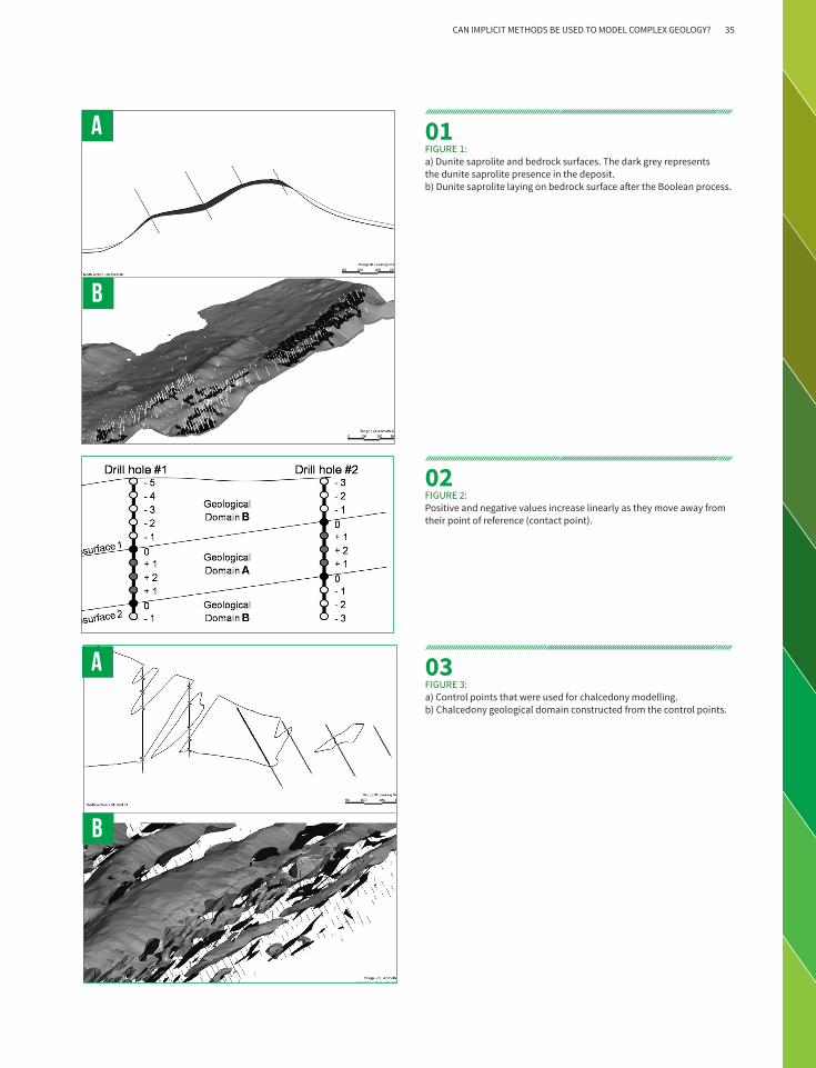
ASSUMPTIONS This study used the same geological assumptions that were applied to the traditional model. The lithotypes were grouped into six geological domains, listed by modelling sequence in Leapfrog:BedrockDunite Saprolite (Basic Ore)ChalcedonyClay(waste)Oxide OreSilicate OreGeological expertise is essential in defining the relationship between geological contacts and stratigraphic sequence.
MODELLING APPLICATIONIn order to model bedrock as a continuous surface, the contact points were extracted directly and interpolated, creating a contact surface for the bedrock. Additional points were included in this process, at the end of the holes that did not intercept the bedrock and, in areas with poor geological information. Both sets of points helped define the bedrock surface.
The dunite saprolite ore bodies have a flat and smooth shape, usually lying on the bedrock surface. This ore type is formed by the weathering process of dunites. To generate this surface, hanging wall contact points from dunite saprolite were used. In addition, in areas where there is no dunite saprolite mineralisation, a minus 2 m offset from the bedrock surface was used to interpolate the dunite saprolite surface (figure 1a). This resulted in a continuous surface along the entire deposit. However, there are only dunite saprolite orebodies where their surface is above the bedrock surface. To guarantee this chronology, Boolean calculations was carried out (figure 1b).
For other rock types exhibiting complex shapes such as strong variations in thickness, length, dip and along the strike, the contact points between the lithotypes were extracted. Once extracted they were converted to a volume function (f(x,y,z)) within Leapfrog. Points inside (>0), points outside (<0) and contact point on surface (=0) were then defined. The points were arranged according to the position (x,y,z) related to the contact point. This equation described the infinite numbers of x,y,z coordinates that lay on the surface. The positive and the negative values increased linearly as they moved away from their point of reference (figure 2). Figure 3a shows the control points that were used for chalcedony modelling and figure 3b shows the geological domain that was constructed from the control points.
FURTHER ADVANTAGES UNCOVERED
Being able to process a very large dataset of various data formats such as drillhole, channel samples, geologic contact points, structural dataset and topography.
Having the flexibility to add both points and control lines to the model in order to better reproduce the geology.
The ability to have the model reproduced to avoid interpretation of subjective bias. This also assisted with due diligence and auditing requirements. Using the same database and parameters (rules), the same isosurfaces and, subsequently, geological domains are created.
The model can be rapidly built and updated, giving geologists time to evaluate more than one scenario.
>
The RBF function can be easily fitted by the user to make the model represent the reality as closely as possible. In this study, many different parametric settings were tested to fit the 3D interpolation for each and every lithotype (such as isotropic/anisotropic, capping values, nugget effect, resolution, directional bias, structural trends) in order to obtain the geometry shapes that best represented the geological deposit.
34 Unearthing 3D implicit modelling
A
B
A
B
01FIGURE 1: a) Dunite saprolite and bedrock surfaces. The dark grey represents the dunite saprolite presence in the deposit. b) Dunite saprolite laying on bedrock surface after the Boolean process.
02FIGURE 2: Positive and negative values increase linearly as they move away from their point of reference (contact point).
03FIGURE 3: a) Control points that were used for chalcedony modelling. b) Chalcedony geological domain constructed from the control points.
CAN IMPLICIT METHODS BE USED TO MODEL COMPLEX GEOLOGY? 35

PETER GLEESON
CORPORATE CONSULTANT, MINING GEOLOGY
SRK CONSULTING, CARDIFF, UK
Implicit modelling technologies on numerous projects worldwide. He has over 29 years of experience in both consultancy and mine production roles. He has worked on resource estimation projects, project evaluations and 3D modelling studies for a variety of different geological environments and commodities, ranging from gold, base metals, uranium through to iron ore. His work experience encompasses mines and exploration projects in Australia, Southern Africa, West Africa, North America, South America, Europe and Indonesia, and he has had extensive global exposure to diverse world class ore deposits and mineral systems. Peter has implemented several innovative geological modelling technologies that have helped to improve the way and effectiveness in which geologists produce 3D geological models, resource estimates and geological interpretations to
facilitate exploration and the evaluation of mineral deposits. He has been at the forefront in the implementation of new implicit modelling technologies on numerous projects worldwide. He is an expert user of several implicit mining / geological modelling software packages, such as GOCAD, Geomodeller, Leapfrog Mining and Leapfrog Geo along with extensive experience in traditional mining software packages such as Datamine and Vulcan. Peter has and continues to act as Competent/Qualified Persons in relation to signing off on Mineral Resource estimates for uranium, gold, base metal and iron ore deposits. Peter has completed and signed off as CP on numerous JORC and NI 43-101 compliant Mineral Resource Estimates.
36 Unearthing 3D implicit modelling
Since the introduction of implicit modelling methods over the last ten years, a common question has been “Are the resultant wireframe models reliable enough to be used for the domaining of resource estimates?”The mining industry has proved somewhat resistant to change and acceptance of resource domain wireframes derived using implicit methods over traditional section CAD based methods. The case for implicit modelling has also suffered from bad press because it provides a conduit for some practitioners to produce rapid and poorly-thought-through
‘blobby’ models that are far from geological in appearance. However, this negative view is changing as more practitioners become familiar with the geological modelling techniques and see the advantages of the implicit approach, which, we argue, outweighs the limitations of traditional sectional wireframing techniques. This brief review does not seek to address all the elements of resource modelling using an implicit approach; however, it touches on key questions and is a starting point for discussion.
The development of a robust resource domain model requires that a practitioner be familiar with the commodity and geology of the deposit, with the geological and statistical justification of the domain and also with the strengths and weaknesses of the methods and software used to generate the model.
In the past, some of the models built using implicit tools were often sub-optimal, tending to reflect the form of a mathematical function rather than a geological shape. This can be put down to the practitioner’s poor knowledge of the algorithms available in the new software and an unfortunate acceptance of such output being suitable for resource domaining. This has changed, with a new generation of geologist now more adept in implicit techniques and with the software itself having similarly evolved. This was equally true of sectional methods in the early days when the GMPs were replacing older 2D techniques.
Careful and relevant geological domaining in resource estimation is crucial as it is the key to developing a robust and reliable resource estimate. Mathematical models alone are not sufficient to accurately define a resource.
Is implicit modelling reliable enough for use in resource domaining?
IS IMPLICIT MODELLING RELIABLE ENOUGH FOR USE IN RESOURCE DOMAINING 37

Conservatism. Resource practitioners are probably the most conservative people in the mining industry (with good reason: as Competent Persons they carry the responsibility for public signing off on Resource statements). They need to feel confident in the models on which their estimates are based and they feel most comfortable with methods that they have used themselves early in their careers.
Distrust of the unknown. Especially when implicit models produce results different from expected (no matter how fundamentally correct and unbiased the implicit results are).
Skill. Lack of training for traditional wireframers makes it difficult to overcome early problems in controlling implicit models, so practitioners quickly revert to their comfort zone of known techniques.
Resistance to Change. Feeling new technology may take away or diminish the job of professional modellers.
Reluctance to accept the implicit approach for resource domaining
“Why do some resource practitioners have difficulty gaining acceptance of implicit wireframe domaining?” Several view points in the mining industry are summarised below:
These views are commonplace in the metalliferous mining industry and are partially justified from people’s early experience with implicit modelling software. However, the software has developed significantly over the last few years, addressing early concerns and incorporating more geologically relevant workflow procedures. In addition, the ability of the geologists to
apply it appropriately has improved. Implicit modelling has reached a stage where many mining companies, operations and consultancies are now realising the technical and financial advantages of the approach and are pursuing it further. As labour costs rise and mines seek new methods to be more efficient, having teams of geologists dedicated to wireframing
over long timeframes is not seen as cost effective.
No model can be generated entirely automatically (not yet anyway) and a hybrid approach of the manual geologist input to steer implicit models is expected to be required for some time. The pendulum has already swung in favour of incorporating implicit methods for many good reasons.
Bad initial experience of implicit techniques. This is commonly due to lack of necessary skills at an early stage to control the model outcome effectively.
Perceived lack of control. A perception that there is a lack of control on development and building of implicit models compared to manual techniques.
Implicit modelling can provide numerous outcomes. Which is the correct model?
Snapping. Does the implicit model snap to points on drillholes?
Requires experience. New software and methods require considerable investment in time to train and gain experience to become a competent user.
Organic look of implicit models. Unease at the organic look of implicit models compared to the structured polygonal look of traditional models (an irrational but common observation). This relates to the long history of CAD-related modelling in the resource industry that makes modellers more comfortable with boxy shapes.
Black Box. The mathematics behind the implicit models is unknown, and, therefore tends not to be trusted.
Is an implicit model JORC compliant?No software or method is JORC compliant. To be JORC compliant requires the input of a Competent Person and appropriate methodology at all levels in the estimate, regardless of software.
38 Unearthing 3D implicit modelling

Reasons for using implicit modelling for resource domaining
Some counter arguments are given below:
Experience has shown that comparisons of volume, grade and geometry of well thought-through implicit models with traditional models are normally favourable. Often, the implicit model’s reliability exceeds that of manual models.
Implicit models are easily repeatable, which makes the incorporation of new data relatively straightforward. The models are also more auditable than manual wireframes.
Implicit methods make it much easier to deal with larger grade control data sets, assisting with 3D interpretation of trends and improving reliability of local grade estimates.
Implicit models provide a better 3D extrapolation when modelling from irregularly spaced data. The models are not sectionally biased as can sometimes occur with manual models.
With complex, high nugget deposits, implicit methods can help deal with linking mineralised intervals between holes better than traditional methods.
Grade and volume dilution can be incorporated with much greater control, often eliminating unnecessary dilution that can/does occur in manual models.
Implicit modelling makes it feasible to produce multiple realisations of a deposit according to a range of assumptions, thereby showing the level of risk inherent in a single model approach.
Surfaces can be generated more rapidly from the data, thereby saving modellers time and companies money.
The new geological workflow now built into several implicit modelling methods enables the geologist to bring more geology into the resource model and produce more geologically refined models.
The speed of the implicit approach gives the geologist more time to spend at the “coal face” gathering fundamental information to inform the model.
A key advantage of the implicit approach is that it gives management the ability to overcome the One Model Syndrome, where the future technical and financial development of a mining project hinges on a single model. Before implicit modelling, models were time consuming and difficult to construct and remained static as they were difficult to update with new data. Implicit technologies allow for multiple realisations of a resource model and can be used alongside the manual model to determine how conservative, liberal or otherwise it is in relation to the informing data, i.e. the level of risk inherent in the model. The implicit approach gives management the chance to determine where the weaknesses of any given geological or resource domain model may lie.
It is often heard that implicit technologies only work well in data rich environments (e.g. grade control). This is something of a myth. Implicit modelling can work as well, if not better, in data poor environments. If data is genuinely sparse, both manual and implicit methods often fail due to the realisation that constructing a model that has no demonstrated geological control or geological continuity is going to be very poorly constrained.
IS IMPLICIT MODELLING RELIABLE ENOUGH FOR USE IN RESOURCE DOMAINING 39

Focus on snappingInnovations such as vein modelling tools mean that exact intersection points can be chosen if required. In other words, implicit technologies can provide the means for snapping, if required, but the reasons for snapping should be examined carefully.
Is snapping to points essential for a good model? One of the questions frequently asked of implicit techniques is do they and should they honour contacts? Often, this refers to the process of snapping in 3D to either grade or geological contacts points on drillholes. The answer is not a simple yes or no. For example, if the contact is a hard geological boundary such as a vein footwall or hanging wall the answer can be yes, snapping can be necessary. However, if it is a soft boundary such as a nuggety gradational grade change, then the answer is not so obvious. In this situation, there is likely not to be a definite contact discernible in the core or in the field and the “contact” becomes a grade contour that serves the purpose of defining ore types for mining.
Figure 1 shows this problem of grade contouring with a typical gold deposit intercept in a drillhole. The intercept was given to several geologists with a broad geological description, minimum mining width and cut off grade, they were asked “Which is the correct point to snap to in order to achieve a required cut off grade domain boundary?” All selected slightly different intervals. The implicitly modelled answer was somewhere between all of the different answers. For each geologist, the contact selected was precise but not necessarily any more correct (accurate) than the implicit solution. In reality, other factors would also be considered, but the point made is that snapping to an absolute point in this case is very subjective and the tight or loose application of ‘rules’ means that snapping is not as important as other considerations, such as complexity and minability of resultant shapes.
The aim of snapping or selecting a grade boundary is to ensure that below cut off grade samples are excluded from the estimate. Typically, from a review of several manually constructed
wireframes, the number of samples below cut off exceeded significantly that selected by implicit methods, despite the geologist snapping to exact points.
Focus on geological modellingAnother common criticism levelled at implicit techniques is the perceived lack of geological and structural control on the grade or ore body outline. In early versions of the implicit technologies, this was indeed the case. Many subsequent refinements and improvements in later versions of implicit software mean this is no longer the case. Complex structural trends can be incorporated into grade boundary models. This is analogous to key features of traditional wireframing of a skeletal framework of the controlling structures underlying the grade distribution. However, using the implicit modelling interpolant to locally follow the structural trend is far simpler and less time consuming than building complex polygonal shapes and trying to tie them together to form a three-dimensional solid.
01FIGURE 1: Selections of grade boundary by five different geologists, compared to an implicit model selection
40 Unearthing 3D implicit modelling

The structural trends themselves can be controlled directly from primary geological inputs of dip and strike (from structural measurements down hole, surface and underground mapping), which is becoming a common approach amongst all implicit software. The rapidity of the implicit approach to build hard geological contacts such as footwall and hanging wall structures encourages the use of rigorous geological domaining where once it may have been given less importance due to time considerations to construct such boundaries. Ore bodies with multiple, complex strike directions that were difficult to build under a traditional sectional approach can now be tackled with greater geological rigor. Recent improvements in vein modelling workflows and grade/contact selections mean simple straight forward vein systems can also be tackled with rigor.
The principles of stratigraphy are now being incorporated into many implicit software packages ensuring easier, logical geological building of models rather than using abstract Boolean operations to build a geological sequence.
A frequent comment about implicit modelling techniques is their inability to introduce manual input and control on a model. Modern techniques can now incorporate local manual control to overcome this issue, if required.
Focus on the mathematical algorithmsProbably the most prevalent criticism of the various implicit approaches is that they are “Black Box”. The actual algorithms used for example in GOCAD’s SKUA are based on the Discrete Surface Interpolator (DSI) algorithm which is well known and documented. The Leapfrog® Radial Basis Function (RBF) is actually based on Dual Kriging, a rapid optimised derivation of Ordinary Kriging . All methods are openly available for review. As in any modelling, no outputs should be trusted without rigorous comparison with the informing data and local geological knowledge. Prudent validation by section and plan with the informing data sets should always be performed on any model regardless of how it is derived.
SummaryThe use of implicit technologies for resource domaining requires a paradigm shift in thought and approach away from the sectional CAD-based techniques that have dominated the industry for over 30 years. Thomas Kuhn (Professor MIT, Harvard, Berkeley 1922-1996) thought of science as a kind of mob psychology and that scientific enterprise was not a purely rational search for truth, but rather an act of construction bound to social forces and constrained by habit and biases . “Only once the groundswell of opinion is sufficient
then the new science or technology become accepted despite how fundamentally correct the theory or technology was in the first place.”
Failure to recognise the importance of new technology is summed up nicely in this quote by Sir William Preece, Chief Engineer of the British Post Office, circa 1876: “The Americans have need of the telephone, but we do not. We have plenty of messenger boys.”
Evidence from numerous comparisons with pre-existing resource domain models over the last few years has demonstrated that, when used correctly by experienced geologists, implicit models can equal or exceed the quality and reliability of manually-derived sectional wireframe methods. However, it is critical that fundamental geological skills be employed when developing any model, regardless of software or method employed.
Malet JL. Discrete smooth interpolation in geometric modelling. Computer aided design 1992, Vol 24,p 178
Chiles J-P and Delfiner P, “Geostatistics Modelling Spatial Uncertainty”, Wiley Interscience, 1999, p 186
Dowd P A, “A review of geostatistical techniques for contouring”, NATA ASI Series, vol F17, Fundamental Algorithms for Computer Graphics. Edited by R.A. Earnshaw Springer Verlag..
Galli A. and Murillo E. “Dual Kriging – Its properties and its uses in direct contouring” Geostatistics for Natural Resources Characterization, NATO ASI Series C: Mathematical and Physical Sciences vol 122 part 2, Dodrecht, Holland, pp 621-634
Kuhn T. 1962. The Structure of Scientific Revolutions
IS IMPLICIT MODELLING RELIABLE ENOUGH FOR USE IN RESOURCE DOMAINING 41

RONALD REID
GROUP RESOURCE GEOLOGIST
HARMONY GOLD SE ASIA
Ron Reid is Group Resource Geologist at Harmony Gold SE Asia. He has 18 years of experience in exploration and mining in Australia, PNG, Africa and Central America, with particular experience in structural geology, geological modelling, resource modelling and prospectivity analysis. Ron has experience across a broad range of commodities, including gold, porphyry and IOCG copper-gold, sediment and structural hosted copper, uranium, iron ore, lead-zinc and nickel. He has been using implicit modelling methods for the last five years.
42 Unearthing 3D implicit modelling

Validating an implicit model
Implicit modelling is one of the most significant improvements introduced to the geological modelling world in a long time [1].
Whilst it was first made well known by Leapfrog® software, at the time of writing the process has been picked up by MICROMINE, Mintec’s Minesight® and Maptek’s Eureka™ and several lesser known programs, with many others sure to follow.
The implicit modelling process is fast and easy to run multiple times in order to test various hypotheses and rapidly assess new datasets. Because of the ease with which the geologist can create and recreate a model, it allows refining of the final output to something approaching reality. Unfortunately, the ease and rapid process can lead to models of pure geo-fantasy. To create meaningful and robust models, as with any modelling process, you require
proper forethought, planning and an understanding of the geology of the area you are studying.
Implicit modelling will not tell you what the geology is doing if you actually have no idea as to what should be happening. It allows you to build the model you have in mind and apply various changes to test the possibilities that may be suggested by analysis of the data.
Both wireframed and implicit geological models require you to understand the geology and the processes around creating them. So for implicit modelling, you need a basic understanding of the interpolation process.
VALIDATING AN IMPLICIT MODEL 43
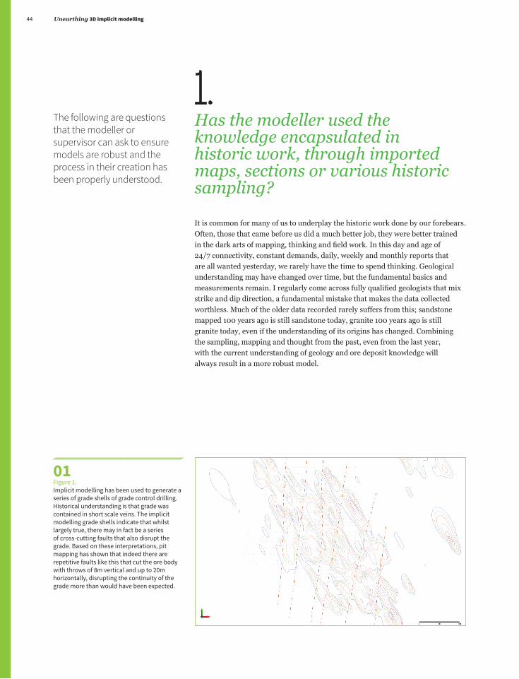
1.Has the modeller used the knowledge encapsulated in historic work, through imported maps, sections or various historic sampling?
It is common for many of us to underplay the historic work done by our forebears. Often, those that came before us did a much better job, they were better trained in the dark arts of mapping, thinking and field work. In this day and age of 24/7 connectivity, constant demands, daily, weekly and monthly reports that are all wanted yesterday, we rarely have the time to spend thinking. Geological understanding may have changed over time, but the fundamental basics and measurements remain. I regularly come across fully qualified geologists that mix strike and dip direction, a fundamental mistake that makes the data collected worthless. Much of the older data recorded rarely suffers from this; sandstone mapped 100 years ago is still sandstone today, granite 100 years ago is still granite today, even if the understanding of its origins has changed. Combining the sampling, mapping and thought from the past, even from the last year, with the current understanding of geology and ore deposit knowledge will always result in a more robust model.
01Figure 1. Implicit modelling has been used to generate a series of grade shells of grade control drilling. Historical understanding is that grade was contained in short scale veins. The implicit modelling grade shells indicate that whilst largely true, there may in fact be a series of cross-cutting faults that also disrupt the grade. Based on these interpretations, pit mapping has shown that indeed there are repetitive faults like this that cut the ore body with throws of 8m vertical and up to 20m horizontally, disrupting the continuity of the grade more than would have been expected.
The following are questions that the modeller or supervisor can ask to ensure models are robust and the process in their creation has been properly understood.
44 Unearthing 3D implicit modelling

2. Has the modeller utilised the information encapsulated inside all the available data?
It is well known that fractal patterns occur in geology over and again. Commonly, what you see on the small scale is reflected on the large, and vice versa. The geological model must make sense on both the deposit scale and also on the larger regional scale. This also occurs across the datasets, where the grade distribution reflects the underlying geology. A folded host may be replicated in folded grade, a faulted ore body will be visible in the grade, perhaps before it is seen in the geology (Figure 1). What is taken as a simple flexure in the geology might be shown to be a fault with sharp offset in the grade. This works both ways, but also at different scales. The use of grade control data in a pit or underground environment can show significant discrepancies that have not been seen in the geology. If the grade control does not make sense with respect to geological host, then something is wrong. If there is a fault modelled but the grade shows no offset, then is a fault really there? If so, is it material?
02FIGURE 2. Implicit modelling was used to create a “robust” geological model for use in targeting gold hosted in a ductile shear along an ultramafic contact. Some simple implicit modelling grade modelling combined with in-depth assessment of the geology showed that the gold tended towards supergene enrichment in and around a folded volcanic horizon hosted within the sediments. A significant step in the basement co-incident with the grade shows the location of what was later modelled as a cross-cutting fault and which subsequently became the feeder for the mineralisation, completely turning the exploration model on its head. (Legend; Ultramafic = purple, volcanic = green, sediments = blue and cover = brown).
VALIDATING AN IMPLICIT MODEL 45

3.Can the modeller describe the model in detail and explain why the process has resulted in the final product?
Does the modeller understand the model? The implicit modelling algorithm may be indicating a dip on an intrusion normally thought to be vertical. It is common to write off the implicit modelling result because we “know” the intrusion is vertical. Implicit modelling does not play favourites. You can try and force the interpolant to do one thing, but it will always try and replicate what is in the geology. It is essentially a blind interpolator. This is the meaning of implicit: it uses the continuity “implicit” in the data without outside influence [2]. We must understand both the interpolation process and the geology. We need to be able to look at the results and read what the algorithm is telling us (Figure 2). Is the algorithm wrong? Or is our understanding of the geology flawed? A modeller who has thought about the model and crafted a result without forcing the implicit modelling algorithm to fit a result in isolation should be able to intelligently explain the resulting model. Using all aspects of geology – igneous, metamorphic and stratigraphic petrology, structural geology, geochemistry, geophysics, volcanology, and economic geology, a full understanding of the mineralisation process and deposit can be obtained and the modeller should be able to call on all this in discussing the result. Equally important is being able to tell which of these aspects of geology are most important for each particular deposit being modelled and how they affect the result.
03AFIGURE 3A. A series of porphyries were modelled explicitly on the “knowledge” that porphyries in these environments always intrude vertically. Whilst the model was complex and never really hung together with respect to the geology in the drilling, it was never fully challenged due to this historic understanding. Close inspection of grade in the drilling shows that the grade appears to start and stop abruptly within and outside of various porphyries. It was postulated that the grade was in fact thrust apart by a series of east-dipping faults (green) and that the whole sequence may be tilted 20 degrees to the east as it ascends a thrust ramp.
46 Unearthing 3D implicit modelling

4.
Does the output look realistic given what we know about the geology or grade distribution?
This question should and must be asked, but can be a double-edged sword. Sometimes what we know about a deposit is simply wrong (Figure 3). So question the model, test it against the known, and dissect it and the knowledge of the geologist that has built it. The model, be it implicit or explicit, might be poorly constructed, poorly thought out and poorly presented. However, just because it does not look the part, don’t dismiss the model outright. It just may be that there is something important that everyone has missed and the data is trying to spit out (Figure 4).
04FIGURE 4 The same deposit presented in Figure 3 but showing a very simple isotropic undirected interpolant on the grade. The data clearly shows that “implicitly” the grade is dipping to the west and dissected by a series of faults (there are more thrusts in this system than shown here). Despite seeing this, it took a long time to convince the audience of the fact that the deposit was tilted because it clashed with the current understanding.
03BFIGURE 3B Despite initial reluctance, mapping and regional studies showed that there were indeed several smaller thrusts cutting the deposit and that there was a large regional thrust just to the west (left) of the image the geology was in fact tilted to the east. With this knowledge, the deposit was remodelled implicitly and the multitude of small low-continuity dykes filled out to become several large consistent but disaggregated porphyry bodies.
VALIDATING AN IMPLICIT MODEL 47
5.Have you utilised the benefits of implicit modelling? Has this model added anything to your knowledge base?
If it hasn’t, perhaps the user needs to reconsider what they are trying to achieve. Every time something new comes onto the market, it is slow to be accepted, largely due to some misunderstanding or misuse. Implicit modelling is no exception; it is still a distrusted application. Everyone looks for the black box with the magic button that, when pushed, will give the correct answer. Implicit modelling has taken a long time to be accepted and has suffered considerable misunderstanding in how it should be used. Now that it has been picked up by the masses and a large number of software companies are building the modules into their programs, I fear we are starting to move into the misuse stage. Sometimes implicit modelling may not be the required tool, nor the best tool for the job. The risk is that implicit modelling will simply be perceived as ‘geological modelling made easy,’ but this is when mistakes are made. It’s essential that people beware of misuse.
When it comes to assessing geology models of all sorts we rely heavily on the people developing the model and expect them to know what they are doing. A bad model is easy to see; a dyke known to be continuous is poddy; a folded stratigraphy is not folded; a cylindrical intrusion has a weird blow out on the north side; a gold grade shell blows out and fills a large area of nothing; a geology model has been built as a square box rather than clipped to a buffered area around our known information. If the modeller presents something like this to senior management, they will cop a bit of flack as they obviously haven’t assessed the geology or had an idea of the outcomes prior to building the model. Implicit modelling is the easiest and fastest way to the wrong result, but used correctly, it will give you 90% of the result for 10% of the work.
Cowen E.J., Beatson, R.K., Fright, W.R., McLennan, T.J., and Mitchell, T,J, 2002. Rapid Geological Modelling. In Applied Structural Geology for Mineral Exploration and Mining International Symposium, Kalgoorlie.
Cowen, E.J., Beatson, R.K., Ross, H.J., Fright, W.R., McLennan, T.J., Evans, T.R., Carr, J.C., Lane, R.G., Bright, D.V., Gillman, A.J., Oshust., P.A., and Titley., M., 2003. Practical Implicit Geological Modelling. In Dominy., S (ed), 5th International Mining Geology Conference, Bendigo, Victoria. AusIMM Publication, pp 89-99.
Footnotes: [1] Cowen et al, 2002; 2003 [2] Ibid.
48 Unearthing 3D implicit modelling

Additional process oriented questions to ask as modellers or assessors:
1. What was the purpose of this particular model and was the outcome achieved?
2. What was your plan and approach to building this model?
3. What chronological order have you placed on the rocktypes and why?
4. Why have you selected to model that particular rocktype in that particular manner?
5. We know that Fault X has a significant effect on the deposit. How has it affected your model? Did you even use it?
6. What other significant structures (faults, fold planes, foliations, etc) have you used and why?
7. Are there any particular rock types you have ignored / merged and why?
8. What is the model trying to tell us that we have not previously thought of?
VALIDATING AN IMPLICIT MODEL 49
LAÉRCIO GUEDES BERTOSSI Resource Geologist, previously with Votorantim, San Paulo, Brazil
In Brazil the major mining companies started to consider using implicit modelling in early 2011. Three years later those wanting to migrate to the implicit approach has increased exponentially. It is an amazing methodology and the Industry can attest to that. The capacity to rapidly build and update models combined with the possibility of testing multiple hypotheses reflects in a much more flexible and dynamic workflow that also saves time and money. It is possible to imagine modellers and geologists remembering when they used to draw lines on regular geological vertical or horizontal cross sections. I am sure this future is not far away.
DR RICHARD LANE Research Director, ARANZ Geo, Christchurch, New Zealand
The widespread introduction of implicit modelling into geological modelling is beginning to make a significant change in how geologists can interact. There is still a long way to go, but the vision of allowing geologists to focus on their data and interpretation, rather than on how to operate a software package is becoming a reality. Effective algorithms, combined with intuitive interfaces and efficient delivery mechanisms may actually yield the surprising result of less time in front of computers and more time in the field.
PAUL HODKIEWICZ Senior Manager Technology Development, BHP Billiton, Perth, Australia
One of the biggest knowledge gaps in the mining industry is between geoscience and geostatistics. We have a good understanding of the science of ore deposit formation. And advanced resource estimation methods allow rapid processing of huge amounts of drill hole data. However, resource models typically anchor on a single geological interpretation. The future of implicit modelling is making it standard industry practice to generate multiple resource models (i.e., multiple working hypotheses) that capture a range of interpretations and the uncertainties associated with them. This will improve communication between geoscience and geostatistics and improve business decisions.
MIKE STEWARTSenior Principal Consultant, QG Pty Ltd, Perth, Australia
Implicit modelling is set to completely replace explicit methods within a few years. The real benefits of implicit modelling are still to be fully realised – rapid updating, incorporation into automated modelling workflows, practical assessment of uncertainty from various sources.
We asked all of our writers to think about where implicit modelling is heading and provide us with a brief statement. A few common threads came through, including implicit modelling replacing explicit wireframing over the next few years, the development of more automated workflows and making the generation of multiple models to test and retest assumptions standard industry practice.
Where is implicit modelling heading?
50 Unearthing 3D implicit modelling

ANTHONY REED 3D Structural Geologist/Information Geologist, MMG, Melbourne, Australia
Implicit modelling interfaces are becoming ever more user friendly and intuitive, with a focus on geological workflows rather than software workflows. Combine this with the increasing number of data categories that can be consumed and updated quickly and effectively into the model, and we have an agile and iterative process that really can be used to conduct meaningful science. I feel the next stage is economically driven, directly linking the model to the real world through augmented reality, and expanding the scope of real time data collection to adjust modelled boundaries and flag unexpected irregularities in Geology, not just topological position. This is critical for accurate and reactive planning to support real-time mining processes, mechanical automation being a major technology to be harnessed into the future both for ground and space based projects.
PATRICK ‘PJ’ HOLLENBECK Independent Consulting Geologist, Colorado, USA
Implicit modelling has already proven to be a huge step forward in the process of building complex geological models. In its wake will be reconsiderations of common practices in the course of resource estimation, and significant improvements in the accuracy and prediction of models will surely follow suit as the result of a more detailed and appropriate geologic model. Most importantly, geologists will get to spend more time being geologists!
PETER GLEESON Corporate Consultant, Mining Geology, SRK Consulting, Cardiff, UK
It is clear from recent advances in implicit modelling and its widespread uptake by the mining industry that its future is secured. Many software developers are now seeing the advantages of, and starting to develop this approach. As the technology matures many of the issues associated with its early development are being overcome. The implicit approach will surely challenge and eventually replace the entrenched traditional sectional wireframing methods of today much as computerised modelling took over from paper based methods of yesterday. As with all methods some manual input will be required to get the best outcomes but this will decrease over time. However the most fundamental input into any resource modelling process will always be geology. Without geology any progress in the software will be meaningless. It is unlikely that the Mining Industry itself (producers and explorers) will revert to the cumbersome manual techniques of the past. Implicit technology has already passed a watershed in this respect. The need to drive costs down, improve efficiencies at the mine and better analyse risk in a mining project will necessitate and drive the future development of implicit modelling techniques. The dynamic nature of mining is best suited to the rapid evaluation of resources made possible by implicit modelling.
RON REID Group Resource Geologist, Harmony Gold SE Asia
The speed of implicit modelling has been fundamental in allowing geologists to test and retest assumptions in the 3D modelling process and freed geologists to spend more time thinking about and tinkering with the final result. As implicit modelling becomes more and more accepted into the mining industry there will be significant improvements in workflow which will greatly improve the validity of the models we generate. As the process becomes more understood and the software moves towards being able to have greater control on domaining and sample selection we will likely see an introduction of implicit modelling derived grade models into the resource sphere.
WHERE IS IMPLICIT MODELLING HEADING? 51
Leapfrog® implicit modelling. From pioneer to world leader. 3D implicit modelling was pioneered in 2004 when Leapfrog was first launched to the market. Since then, the product suite has been improved and refined for 10 years. Close ties to the industry, an in-house team of expert geologists, and an agile and responsive development team has ensured Leapfrog consistently exceeds expectations.
With thousands of users ranging from the largest global mining firms through to consultants, Leapfrog has cemented itself as the world leader and continues to set the standard in geological modelling.
Leapfrog’s goal is simple; to give geologists the time and opportunity to reduce risk for their organisation.
Direct from data modellingBypass wireframing to build and update models significantly faster
Unrivalled processing powerModel highly complex geology with ease by harnessing over one million data points
Evaluation of multiple modelsImprove geological understanding by duplicating models to test various hypotheses
Thoughtfully crafted for geologists Save time and frustration with logical workflows and a beautifully simple interface
52 Unearthing 3D implicit modelling

The Leapfrog engineThe quality of an implicit modelling engine lies in the algorithms which determine how known data is used to imply (or estimate) otherwise unknown data to create surfaces. Radial Basis Functions (RBF’s) are the basic method to do this.
We set out to create an advanced implicit modelling engine. Years of interpolation research by leading mathematicians culminated in the creation of FastRBFTM, the algorithm that powers Leapfrog.
The main difference between traditional RBF’s and FastRBF™ is the ability to deal with over 1,000,000 data points incredibly quickly on an ordinary computer. Filtering and approximation methods make FastRBF™ ideal for visualising and processing non-uniformly sampled noisy data. FastRBF™ has extraordinary extrapolation capabilities, even when large gaps occur in a data set. Since 2004 the Leapfrog algorithms have been continually improved to create tailored outcomes based on the type of geological structure being modelled.
Contact your local Leapfrog team for a demo, trial or quote
www.leapfrog3d.com/contact
The views, opinions and positions expressed by the authors are theirs alone, and do not necessarily reflect the views, opinions or positions of ARANZ Geo Limited, any employee thereof, or any employer or associate of the authors. We make no representations as to accuracy, completeness, timeliness, suitability or validity of any information presented by individual authors and will not be liable for any errors, omissions, or delays in this information or any losses, injuries or damages arising from its display or use.
LEAPFROG® 53


SPONSORED BY
www.leapfrog3d.com

SPONSORED BY
www.leapfrog3d.com