importance of space-based information for disaster ... · importance of space-based information for...
TRANSCRIPT

Importance of Space-based Information for
Disaster Assessment and Prevention
Liu Longfei UN-SPIDER
(United Nations Office for Outer Space Affairs)
ICDO International Seminar on Application of Communication Technology in Disaster Reduction and Prevention Suzhou, 26 May 2014

2
Resource and Mechanism
Space-based Information for Disaster Management
2
1
Role of UN-SPIDER
Key Messages
3
4
Space-based Information for Disaster Management
3
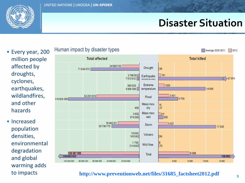
• Every year, 200 million people affected by droughts, cyclones, earthquakes, wildlandfires, and other hazards
• Increased population densities, environmental degradation and global warming adds to impacts http://www.preventionweb.net/files/31685_factsheet2012.pdf
Disaster Situation

4
http://www.preventionweb.net/files/31685_factsheet2012.pdf

5
Bangkok Floods (2011) Japan Tsunami (March 2011) -28,500 died or missing -Nuclear emergency
Typhoon Bopha, Philippines(Dec 2012) -1,901 died
$294 billion economic losses – representing 80 per cent of global losses due to disasters in 2011 (Source: Asia Pacific Disaster Report, 2012)
Typhoon Haiyan, Philippines (Nov 2013) -nearly 6,000 died -displace more than 3.6 million.

6

Disaster Management
A continuous and integrated process of planning, organizing, coordinating, and implementing measures which are necessary for
Prevention of danger or threat of any disaster Mitigation or reduction of risk Capacity Building Preparedness Prompt Response Severity or Magnitude assessment Evacuation, Rescue, Relief Rehabilitation & Reconstruction
Disaster Management

Relief
Rehabilitation
Reconstruction
Preparedness
Mitigation
Disaster
Disaster Management Cycle
Disaster Management

United Nations Platform for Space-based Information for Disaster Management and Emergency Response (UN-SPIDER) 9
Images from earth observing satellites help assess the damage caused by disasters and assess
vulnerability to hazards.
Global navigation satellite systems enable us to obtain positional information on
events that have to be mapped
Satellite communications help warn people who are at risk, especially in remote areas. They help connect a disaster zone to the outside world
Space Technologies for Disaster Management

United Nations Platform for Space-based Information for Disaster Management and Emergency Response (UN-SPIDER) 10
Spatially extensive mapping
Beyond ‘human eye’ capability
Localised event detection
Access difficult or dangerous sites
Near real time response
Geo-referenced and calibrated
More than 40 nations with imaging satellites -160 sensors
Earth Observation from Space

GLCF
NOAA
OrbView MODIS
Landsat ASTER SRTM
NOAA
LandScan
TRMM GIS data - Base maps - Thematic maps
• Predictions of weather extremes
• Early warning
• Monitoring of disasters and risks
Crowdsource
Geospatial information products –Increasing access and availability

Mitigation & Preparedness
Planning
Vulnerability and risk
assessment
Modelling impact
Early warning
Emergency Response
Specific event
Rapid provision
Map information
Support crisis management
Recovery & Rehabilitation
Situation maps
Time series
Monitoring
Global scale
Local scale
Life Saving Products
Hazard maps Vulnerability maps Risk maps Response maps
‘Space’ in Disaster Management

13
Flood Monitoring

Satellite images provide bird eye view as well as detailed information
Tsunami/flood monitoring from Space

Time series of high resolution imagery in New Orleans (a) Before Hurricane Katrina; (b)
Soon after the height of the storm; (c-j) Various time intervals following the recovery
process; and (k) Interpreted rate of recovery 15

16
House Damage Assessment in Yushu Earthquake

17
Tents Monitoring in Yushu Earthquake

Rapid Mapping mechanism with UN-SPIDER(NDRCC)
10 Monitoring and Assessment map distribute to Africa via UN-SPIDER
18
Drought Monitoring

19
Resource and Mechanism
Space-based Information for Disaster Management
2
1
Role of UN-SPIDER
Key Messages
3
4

Spatial Data
20
Effective use of space-based information is possible
only if spatial data on other aspects is integrated
with the space-based information
- administrative boundaries
- infrastructure details,
- settlements
- socio-economic data
- disaster related data

21
Baseline data serve as the
reference data such as
administrative boundaries,
human settlements, rivers,
drainage, roads and basic
infrastructure etc.
GeoNetwork
GeoNetwork Links
FAO GeoNetwork
http://www.fao.org/geonetwork/srv/en/main.search
WFP GeoNetwork
http://vam.wfp.org/geonetwork/srv/en/main.home
WHO GeoNetwork http://www.who.int/geonetwork/srv/en/main.search
OCHA GeoNetwork
http://geonetwork.unocha.org/geonetwork/srv/en/main.home

22
Link
International Network of Crisis Mappers http://crisismappers.net/
Crisis Commons http://crisiscommons.org/
OpenStreetMap http://openstreetmap.org
Ushahidi http://ushahidi.com/
MapAction http://mapaction.org
Google Crisis Response http://google.org/crisisresponse/
The most active volunteer communities, platforms and technology providers
In the field of disaster and risk management, Crowdsourcing refers to the possibility of communities and individuals to collect disaster relevant information via various communication channels and social media platforms thus fitting several small pieces of information into a
larger picture.
CrowdSourcing Data

23
Satellite imagery
ASTER
Ikonos
Quickbird
Orbview
Landsat
MODIS
SRTM
Products
Landsat
MODIS
AVHRR
Special Collections
Elevation Data
GOES
Reference
http://glcf.umd.edu/data/
Global Land Cover Facilities
24
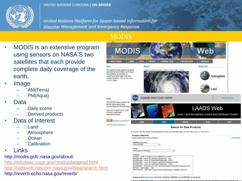
• MODIS is an extensive program
using sensors on NASA’S two
satellites that each provide
complete daily coverage of the
earth.
• Image – AM(Terra)
– PM(Aqua)
• Data – Daily scene
– Derived products
• Data of Interest – Land
– Atmosphere
– Ocean
– Calibration
• Links http://modis.gsfc.nasa.gov/about/
http://edcdaac.usgs.gov/modis/dataprod.html
http://ladsweb.nascom.nasa.gov/data/search.html
http://reverb.echo.nasa.gov/reverb/
MODIS

25
• Data center
• Products
• Links http://www.nesdis.noaa.gov/
http://www.nesdis.noaa.gov/SatProduct s.html http://www.class.ncdc.noaa.gov/saa/products/welco
me
NOAA
26
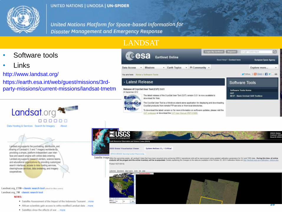
• Data
• Software tools
• Links http://www.landsat.org/
https://earth.esa.int/web/guest/missions/3rd-
party-missions/current-missions/landsat-tmetm
LANDSAT

27
Links http://earth.google.com/
Google Earth

UN-SPIDER
UN Affiliated Regional
Centres Asia, Africa, Latin America
Emergency Support Mechanisms
Space Applications Initiatives
Capacity Building, outreach, technical support
Regional Support
Offices & Partner
Organisations
Mechanisms

29
International Charter- Space and Major Disaster
www.disasterscharter.org
The Charter is a
worldwide collaboration,
through which satellite
data are made available
for the benefit of
disaster management..
The uniqueness of the
initiative lies in being
able to mobilize
agencies around the
world and benefit from
their know-how and
their satellites through a
single access point that
operate 24 hours a day,
7 days a week and no
cost to the user

30
Copernicus Emergency Management service
Links: http://emergency.copernicus.eu/mapping

31
Sentinel Asia
• Led by JAXA, supported by major space agencies within Asia (ISRO, KARI, GISTDA)
• Quick data delivery via the internet as easy-to-interpret disaster-related information (WINDS)
• Working Groups: Wildfire monitoring, Flood monitoring and Glacier Lake Outburst Flood monitoring
http://dmss.tksc.jaxa.jp/sentinel/contents/EOlogin_web.html

Regional Visualization and Monitoring
System for environmental management and
disaster response
Regional SERVIR nodes are located at
– the Water Center for the Humid Tropics of Latin
America and the Caribbean (CATHALAC) in
Panama
– the Regional Center for Mapping of Resources for
Development (RCMRD) based in Kenya
– International centre for Integrated Mountain
Development (ICIMOD) located in Kathmandu,
Nepal.
32
SERVIR

33
Resource and Mechanism
Space-based Information for Disaster Management
2
1
Role of UN-SPIDER
Key Messages
3
4

Context
Scientific and Technical Subcommittee
Legal Subcommittee
COPUOS
UN-SPIDER
Committee for Peaceful Uses of Outer Space
Hyogo Framework for Action
Inter Agency Meeting

“Ensure that all countries and international and regional organizations have access to and develop the capacity to use all types of space-based information
to support the full disaster management cycle.” • Especially by being a gateway to space information for disaster
management support; • serving as a bridge to connect the disaster management and space
communities; and • being a facilitator of capacity-building and institutional strengthening
(A/RES/61/110).
Space-based Information for Disaster Management and Emergency Response

United Nations Platform for Space-based Information for Disaster Management and Emergency Response (UN-SPIDER)
Activities
• Knowledge Management
• Technical Advisory Support
• Capacity Building
• Fostering Cooperation
www.un-spider.org (Knowledge Portal)

Network of Regional Support Offices
RSO Algeria
RSO Nigeria
RSO I.R. Iran
ICIMOD
RSO Ukraine RSO Romania
RSO Pakistan
RSO ADRC
The UN-SPIDER Programme
RSO CATHALAC
RSO UWI
RSO Indonesia
RSO RCMRD
RSO Colombia
• UN-SPIDER Team
• Network of Regional Support Offices (RSOs) (16)
• National Focal Points (45)
UN-SPIDER
Beijing Office UN-SPIDER
Bonn Office
UN-SPIDER
in Vienna
RSO Hungary
RSO Russian Federation
RSO Argentina

Guatemala
Ecuador
Jamaica
Dominican Rep.
Fiji
Tonga
Nigeria
Namibia Mozambique
Malawi
Cameroon
Cabo Verde
Togo
Burkina Faso Sudan
Myanmar
Sri Lanka
Bangladesh
Samoa
Solomon Islands
Maldives
Vietnam
Ghana
Technical Advisory Missions (2008 - 2013)
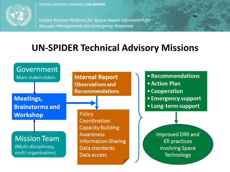
UN-SPIDER Technical Advisory Missions

Technical Advisory Support
ASIA • Afghanistan • Bangladesh • India • Maldives • Sri Lanka • Philippines • Myanmar • Vietnam
Africa • Burkina Faso • Cameroon • Ghana • Kenya • Madagascar • Malawi • Mozambique • Namibia • Nigeria • Sudan • Togo • Zambia
Pacific • Fiji • Samoa • Solomon Islands
Latin America and Caribbean • Chile • Colombia • Dominican Republic • Ecuador • El Salvador • Guatemala • Haiti
Myanmar Bangladesh
Solomon Islands
Sri Lanka

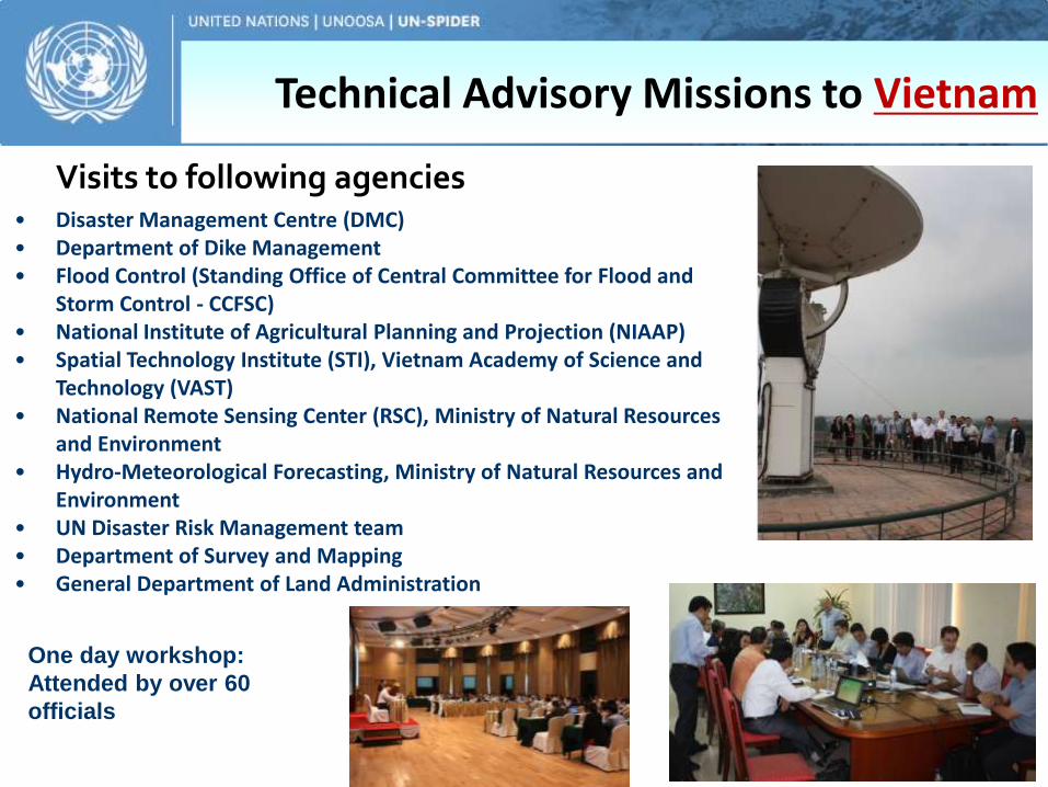
Technical Advisory Missions to Vietnam
Mission team • UN-SPIDER
• UN OCHA • CANEUS, Canada • NDRCC, China • ITC, Netherlands • CNES-CNRS University,
France • Pacific Disaster Center, USA • Chinese Academy of
Sciences • Delta State University, USA • GERENDIS, Spain • GREEN Mindanao,
Philippines
• Disaster Management Centre (DMC) • Department of Dike Management • Flood Control (Standing Office of Central Committee for Flood and
Storm Control - CCFSC) • National Institute of Agricultural Planning and Projection (NIAAP) • Spatial Technology Institute (STI), Vietnam Academy of Science and
Technology (VAST) • National Remote Sensing Center (RSC), Ministry of Natural Resources
and Environment • Hydro-Meteorological Forecasting, Ministry of Natural Resources and
Environment • UN Disaster Risk Management team • Department of Survey and Mapping • General Department of Land Administration
Visits to following agencies
One day workshop:
Attended by over 60
officials
Technical Advisory Missions to Vietnam

Technical Advisory Missions to Vietnam
• Policy and Coordination
• Data access, availability and sharing
• Capacity Building and Institutional Strengthening
• Specific recommendations to address various stages of disaster management
• risk reduction,
• early warning,
• emergency response etc.
Classes of recommendations

Technical Advisory Missions to Vietnam
• Wide dissemination of the TAM report and recommendations
• UNDP and UNRC offices in Vietnam to consider the recommendations
• High level intervention (at ministerial level) to encourage data sharing and Data Policy.
• Short term training programmes
• Institutional capacity building of DMC
• Familiarisation study tours to overseas operational "centres of excellence".
• Act as the bridge during emergencies to supply EO products
• Effective utilization of VinAWARE, a tool provided by PDC to facilitate the integration of geospatial and early warning information
Follow up actions
After debriefing presentation to the Vice Minister of Agriculture & Rural
Development

Opportunities
Capacity building • 7 UN affiliated centres space science technology
education
• Regional Support Offices (ADRC, Iran, Pakistan)
• NDRCC

UNOOSA 46
UN Affiliated Regional Centres for Space Science Technology Education
Western Asia
Jordan
Beihang University
China

UN-SPIDER Capacity Building Efforts
National training programmes in 2013 Sri Lanka China Myanmar Cameroon, Mozambique, Sudan Bangladesh
International training programmes in 2013
China- with NDRCC and APSCO UN Affiliated Regional Centre in India (With ESCAP and IWMI)

Opportunities
• UN-SPIDER workshops and conferences
• Regional meetings
• News letters and updates
Outreach and Awareness
UN-SPIDER Conference in 2011 in Beijing
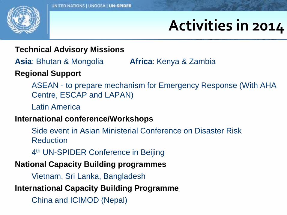
Technical Advisory Missions
Asia: Bhutan & Mongolia Africa: Kenya & Zambia
Regional Support
ASEAN - to prepare mechanism for Emergency Response (With AHA
Centre, ESCAP and LAPAN)
Latin America
International conference/Workshops
Side event in Asian Ministerial Conference on Disaster Risk
Reduction
4th UN-SPIDER Conference in Beijing
National Capacity Building programmes
Vietnam, Sri Lanka, Bangladesh
International Capacity Building Programme
China and ICIMOD (Nepal)
Activities in 2014

Announcement
United Nations International Conference on Space-based Technologies for Disaster Management – “Multi-hazard Disaster Risk Assessment“ in Beijing. Conference dates: 15-17 September 2014 Training dates: 18-19 September 2014 http://www.un-spider.org/BeijingConference2014

Key Messages
• Space-based technologies can improve predictions and monitoring of potential hazards.
• Space technology needs consideration as mainstream tool in the national development and disaster management.
• Importance of raising awareness and strength capacity.
• collaborations between the disaster management community and geospatial community.
