improving access to onshore oil & gas resources on federal
TRANSCRIPT

Improving Access to Onshore Oil & Gas Resources on
Federal Lands
Project Funding: U.S. DOE-NETL
Prepared for:
Interstate Oil & Gas Compact Commission
Prepared by:
ALL Consulting
March 2007

THIS PAGE INTENTIONALLY LEFT BLANK

IMPROVING ACCESS TO ONSHORE OIL & GAS RESOURCES ON FEDERAL LANDS
Project Researchers & Cooperating Agencies
Improving Access to Onshore Oil & Gas Resources on Federal Lands
ACKNOWLEDGEMENTS
This project was funded by the National Energy Technology Laboratory (NETL) of the
U.S. Department of Energy (DOE) program “Focused Research in Federal Lands Access
and Produced Water Management in Oil and Gas Exploration and Production”. The
project was developed under the Area of Interest 1: Improving Access to Onshore Oil
and Gas Resources on Federal Lands, and Topic 3: Data Management.
The Interstate Oil and Gas Compact Commission (IOGCC) and ALL Consulting (ALL)
conducted this study as co-researchers in cooperation with the oil and gas agencies of
Alaska (Alaska Oil and Gas Conservation Commission), Montana (Montana Board of Oil
and Gas Conservation), and Wyoming (Wyoming Oil and Gas Conservation Commission),
as well as the Alaska Department of Natural Resources. The effort was overseen by
NETL’s, National Petroleum Technology Office in Tulsa, Oklahoma. The National
Petroleum Technology Office project manager for this effort was Mr. John Ford. The
research team also extends its appreciation to those companies operating in the Powder
River, Big Horn, Williston, North Central Montana, Anadarko, Arkoma, Alaska North
Slope, Cook Inlet, Permian and Fort Worth Basins, and the staffs of the Department of
the Interior, Department of Agriculture, Environmental Protection Agency, and the
various state agencies who provided the technical input and assistance that enabled
DOE to improve the scope and quality of the analysis.
DE-PS26-04NT15460-01

Improving Access to Onshore Oil & Gas Resources on Federal Lands
DISCLAIMER
This report was prepared as an account of work sponsored by an agency of the United
States Government. Neither the United States Government nor any agency thereof, nor
any of their employees, makes any warranty, express or implied, or assumes any legal
liability or responsibility for the accuracy, completeness, or usefulness of any
information, apparatus, product, or process disclosed, or represents that its use would
not infringe privately owned rights. Reference herein to any specific commercial product,
process, or service by trade name, trademark, manufacturer, or otherwise does not
necessarily constitute or imply its endorsement, recommendation, or favoring by the
United States Government or any agency thereof. The views and opinions of authors
expressed herein do not necessarily state or reflect those of the United States
Government or any agency thereof.

Improving Access to Onshore Oil & Gas Resources on Federal Lands
THIS PAGE INTENTIONALLY LEFT BLANK

Improving Access to Onshore Oil & Gas Resources on Federal Lands
i
TABLE OF CONTENTS LIST OF FIGURES .............................................................................................. iii
LIST OF TABLES ................................................................................................ iv
I. PURPOSE AND OVERVIEW..........................................................................1 A. INTRODUCTION ....................................................................................................1 B. PURPOSE AND NEED...............................................................................................8 C. OVERVIEW OF RESEARCH ........................................................................................9 D. PROJECT ADVISORY COUNCIL.................................................................................12 E. SUMMARY OF FUTURE RESEARCH AND OBJECTIVES (PHASE II) .......................................12
II. INTRODUCTION TO ONSHORE OIL & NATURAL GAS DEVELOPMENT ..13 A. HISTORY AND EVOLUTION OF THE ONSHORE OIL AND GAS INDUSTRY..............................16 B. THE PROCESS OF ONSHORE OIL AND GAS DEVELOPMENT..............................................25
III. REGIONAL ENVIRONMENTAL VARIATIONS..........................................35 A. GEOLOGY ..........................................................................................................36 B. CLIMATE............................................................................................................42 C. BIOLOGICAL FEATURES .........................................................................................49 D. HYDROLOGY.......................................................................................................50 E. SURROUNDING HUMAN ACTIVITIES ..........................................................................52
IV. MANAGEMENT CONSIDERATIONS BY AGENCY.....................................57 A. DISTRIBUTION OF FEDERAL LAND MANAGEMENT.........................................................59 B. OIL & GAS MANAGEMENT ON FEDERAL LANDS............................................................61 C. FEDERAL AGENCIES INVOLVED IN OIL & GAS DEVELOPMENT..........................................62 D. OTHER FEDERAL AGENCIES INVOLVED IN THE OIL AND GAS INDUSTRY ............................75
V. REGULATORY FRAMEWORK AND THE NEPA PROCESS ............................79 THE NATIONAL ENVIRONMENTAL POLICY ACT ................................................................79 OVERVIEW OF STATE ENVIRONMENTAL POLICY ACTS .......................................................83 EVOLUTION OF NEPA RELATIVE TO THE OIL AND GAS INDUSTRY .......................................86
VI. IMPACT ANALYSIS METHODOLOGY......................................................95 A. GENERAL FRAMEWORK FOR ASSESSMENT ..................................................................96 B. DATA SHORTFALLS............................................................................................. 101 C. PHYSICAL AND BIOLOGICAL RESOURCES.................................................................. 102 D. HUMAN AND MANAGEMENT RESOURCES.................................................................. 147
APPENDIX A ...................................................................................................159 SWANSON RIVER OIL & GAS FIELD CASE STUDY .........................................159
A. INTRODUCTION................................................................................................. 161 B. OBJECTIVE AND PURPOSE .................................................................................... 165 C. REGULATORY AND HISTORICAL OVERVIEW OF THE KENAI NATIONAL WILDLIFE REFUGE ..... 166

Improving Access to Onshore Oil & Gas Resources on Federal Lands
ii
APPENDIX B ...................................................................................................183 BADGER HILLS COAL BED NATURAL GAS CASE STUDY.................................183
A. INTRODUCTION................................................................................................. 186 B. OBJECTIVE AND PURPOSE .................................................................................... 186 C. ASSUMPTIONS USED IN DEVELOPING THE COMPARISONS OF IMPACTS ............................ 187 D. SURFACE DISTURBANCE IMPACTS.......................................................................... 188 E. AIR QUALITY .................................................................................................... 192 F. CULTURAL RESOURCES........................................................................................ 196 G. LANDS AND REALTY ........................................................................................... 198 H. SOCIAL AND ECONOMIC CONDITIONS..................................................................... 199 I. SOILS.............................................................................................................. 201 J. WATER RESOURCES............................................................................................ 203 K. VEGETATION .................................................................................................... 207 L. WILDLIFE......................................................................................................... 209
VII. REFERENCES........................................................................................213

Improving Access to Onshore Oil & Gas Resources on Federal Lands
iii
LIST OF FIGURES Figure 1 United States Domestic Oil and Natural Gas Production and Consumption.......3 Figure 2 Map of Top 100 Oil and Gas Fields in the United States..................................5 Figure 3 Federal Surface and Surface Managing Agencies ...........................................6 Figure 4 Distribution of Participating States in this Study...........................................11 Figure 5 Oil and Gas Energy Production for the United States from the Year 2000. .....14 Figure 6 Annual Oil and NGL Production Rates – 1935 to 2010; peak is reached in early
1970’s..............................................................................................................14 Figure 7 Annual Natural Gas Production Rates – 1930 through 2006 :peak is indicated at
1973................................................................................................................15 Figure 8 Oil and Natural Gas Producing Regions in the United States. ........................17 Figure 9 Summary of the Phases of Oil and Gas Development ...................................27 Figure 10 Total Dissolved Solids from the Produced Waters Database in the United
States ..............................................................................................................40 Figure 11 Average Annual Precipitation Across the United States ...............................44 Figure 12 Hydrocarbon Production by Region and Resource in the United States. .......45 Figure 13 Salinity Comparison for Two Watersheds Montana vs. Texas. .....................53 Figure 14 Management Distribution of Subsurface and Surface Mineral Resources ......61 Figure 15 Bureau of Land Management Field Offices and Office Boundaries ...............65 Figure 16 National Wildlife Refuges with Oil and Gas Wells........................................68 Figure 17 Distribution of USFS Lands According to Lease Terms or Stipulation
Categories........................................................................................................73 Figure 18 Map of States with State Environmental Policy Acts and Environmental Review
Processes.........................................................................................................81 Figure 19 Federal Environmental Impact Statements Filed Since the Passing of NEPA in
1970................................................................................................................87 Figure 20 The Cumulative Effects Analysis Process ................................................. 101 Figure 21 Pre-Plan Development Biological Evaluation Flowchart ............................. 117 Figure 22 Defining the Visual Environment for NEPA Impact Assessment ................. 125 Figure 23 BLM Swatch of Standard Environmental Colors ......................................... 127 Figure 24 Pumpjack Painted to Minimize Contrast with Surrounding Environment. .... 129 Figure 25 Cook Inlet Oil & Gas Fields ...................................................................... 162

Improving Access to Onshore Oil & Gas Resources on Federal Lands
iv
Figure 26 Swanson River Oil and Gas Field Production ............................................. 164 Figure 27 National Wildlife Refuges with Oil and Gas Wells....................................... 170 Figure 28 The Comprehensive KNWR Planning Process ........................................... 178 Figure 29: EPA Monitored Annual Laboratory Rainfall pH Data................................. 193 Figure 30 Comparison of the Water Produced in Association with CBNG................... 206
LIST OF TABLES Table 1 Produced Water Quality for Oil and Gas Basins in the United States ................41 Table 2 Acres of Land Managed by Federal Agencies ................................................60 Table 3 State Environmental Policy Acts and the Need for EISs. ................................85 Table 4 Litigation Summary for NEPA Documents from 2001-2004.............................88 Table 5 Plaintiffs in NEPA Lawsuits by Group and Year ...............................................89 Table 6 EPA Ratings of Draft Oil and Gas Project Environmental Impact Statements for
2004-2005. ......................................................................................................93 Table 7 EPA Ratings of All Draft Environmental Impact Statements Reviewed in 2004 -
2005................................................................................................................94 Table 8 Soil Erodibility Factors (LS) for New Construction Sites with Little to No Cover104 Table 9 BLM Recommended Maximum Spacing of Cross-Drain Culverts (feet) ........ 106 Table 10 BLM Visual Resource Guidance on Contrast Ratings .................................. 127 Table 11 Noise Levels Generated by Various Types of Construction Equipment.......... 138 Table 12 Land Status of the Kenai National Wildlife Refuge ..................................... 173 Table 13 Comparison of Assumptions from MT FEIS and Badger Hills EA................... 188 Table 14: Surface Disturbance Acreage for the Badger Hills Project. ......................... 189 Table 15: Level of Surface Disturbance Comparison................................................. 191 Table 16: Summary and Comparison of Cumulative Air Quality Impacts ................... 194 Table 17: EPA Air Quality Report of Criteria Pollutant Data for 3 Counties in Montana.195

Improving Access to Onshore Oil & Gas Resources on Federal Lands
1
I. PURPOSE AND OVERVIEW
A. INTRODUCTION
The United States relies on oil and natural gas to supply a significant portion of the
nation’s energy. These fuels currently supply greater than 60 percent of the nation’s
energy and are the prime transportation fuels supplying nearly 100 percent of the
nation’s needs (NEPDG, 2001). The energy needs of the United States are greater than
domestic sources are currently supplying, a situation which is expected to continue at an
ever increasing rate as the energy needs of the United States rise in the future. The
Bush Administration’s Energy Policy highlighted the means to meet the nation’s future
energy needs through conservation, increasing domestic supplies, strengthening the
energy infrastructure and increasing alternative and renewable fuels (NEPDG, 2001),
while sustaining environmental responsibilities and strengthening foreign alliances. The
National Energy Policy Development Group which provided the basis for the Bush
Administration’s Energy Policy suggested that one way to increase domestic on-shore
production is to increase access to federal lands thus producing more of our own oil and
natural gas resources. The federal government owns approximately 30 percent of the
land in the United States, with much of the nation’s public lands estimated to have
substantial undiscovered energy resources (NEPDG, 2001) representing a favorable
source for increased domestic production. Therefore, access to federal lands for the
leasing and development of oil and natural gas resources is critical to meeting the
nation’s current and future energy demands.
Considering the national importance access to federal lands has for energy development
and supply, it is also critical to understand and address associated environmental and
social concerns related to activities involving development on federal lands. This
document is intended to serve as a reference and source of information for operators,
land managers, and other stakeholders to more efficiently access the onshore oil and
natural gas resources that are present under federally owned lands within the United
States. Further, this document incorporates detailed information and guidance specific to
requirements of the National Environmental Policy Act (NEPA) as it pertains to oil and
natural gas leasing and development. This combination of information serves as a basis
that can be leveraged to improve access to federal lands in an environmentally and
technically sound manner.

Improving Access to Onshore Oil & Gas Resources on Federal Lands
2
The need to improve access to federally administered minerals is perhaps best
demonstrated through historic and current statistics of oil and gas development.
Statistics from the Energy Information Administration (EIA), the agency which tracks
energy related data, demonstrates how the consumption of energy from oil and natural
gas resources in the United States is outpacing domestic production (Figure 1). Figure 1
shows that current domestic supply of crude oil is approximately 5.5 million barrels per
day, while consumption of crude oil is in excess of 20 million barrels per day; a domestic
production shortfall of 14.5 million barrels per day (EIA, 2005). Projections for domestic
production of crude oil show production fluctuating at approximately 5.5 million barrels
per day through 2015, after which production is predicted to slowly decline (Figure 1).
Consumption of crude oil is expected to steadily increase to over 27.5 million barrels per
day by 2030, which would result in a domestic production shortfall of more than 20
million barrels per day (Figure 1).
The Energy Information Administration projections for natural gas through 2030 are also
shown in Figure 1. Current natural gas consumption is greater than domestic natural
gas production, yet the natural gas domestic production shortfall is not as large as the
shortfall seen for crude oil. The difference between domestic production of natural gas
and consumption was approximately 4 trillion cubic feet (TCF) per day in 2003. While
production of natural gas is expected to grow over the next 15 years, consumption is
expected to grow at a faster rate which is predicted to result in a domestic production
shortfall of approximately 7 TCF/day by 2030 (Figure 1). These projections illustrate the
need the National Energy Policy Development Group identified for increasing domestic
production of oil and natural gas resources from domestic reserves in order to help
offset the need to import increasingly larger amounts of oil and gas resources from
other producing countries.
The United States Geological Survey’s (USGS’s) national assessment of oil and gas
resources estimates the current mean oil and gas resources of the United States to be
47.3 billion barrels of oil, 622 TCF of total natural gas, and 11.4 billion barrels of natural
gas liquids (USGS, 2005). Analysis of oil and gas fields with the highest known reserves,
as shown in Figure 2, indicate that these oil and gas fields are located predominantly in
five regions: California, the Rocky Mountain States, the south-central United States,
Alaska, and the Gulf of Mexico. The map of the United States in Figure 3 shows the
federal surface distinguished by the various federal agencies which manage federally
administered surface. Federal lands comprise approximately 30 percent of the United

Improving Access to Onshore Oil & Gas Resources on Federal Lands
3
Cru
de O
il (m
illio
ns o
f bar
rels
/day
N
atur
al G
as (T
rillio
ns o
f cub
ic fe
et/y
ear)
States with the majority of the surface being located in the western half of the United
States, including Alaska (Figure 3). A comparison of the maps in Figure 2 and Figure 3
identifies two regions that have large proven oil and gas reserves corresponding with
large areas of federal administered surface: Alaska and the Rocky Mountain States.
Figure 1 United States Domestic Oil and Natural Gas Production and Consumption
Graph depicts estimated domestic oil and natural gas production and consumption through 2030 (EIA, 2005)
The Rocky Mountain Front contains considerable oil and natural gas reserves (Figure 2)
and is a region with vast areas of Forest Service; Bureau of Land Management (BLM);
Fish and Wildlife; and National Park Service administered lands. While Alaska’s North
Slope contains reserves that are estimated to contain the greatest untapped oil and
natural gas reserves in the United States most of which are administered by the Fish
and Wildlife Service (USGS, 2005).
There are numerous federal agencies which administer federal surface estates as Figure
3 shows, and each of the agencies has its own administrative land uses for the areas
they manage. Only one federal agency, the BLM, is responsible for managing the 700

Improving Access to Onshore Oil & Gas Resources on Federal Lands
4
million acres of subsurface mineral estates and is solely responsible for the leasing of
fluid minerals on all Federal Lands (BLM, 2005a). While the BLM is solely responsible for
managing oil and gas leasing of federal mineral estates, the issuance of oil and gas
leases and permits is not the BLM’s sole responsibility. Efforts to increase oil and gas
production from domestic federally managed reserves would, therefore, require the BLM
to have the highest level of involvement. However, the involvement of multiple land
management agencies complicates the federal decision-making process for developers.
There are a variety of reasons why oil and gas resources located on federal lands have
not been previously developed to their full potential. To date, development has been
limited by lease restrictions and stipulations which impede leasing on some of the
federal lands, delays in obtaining federal permits, conflicts with the existing land uses,
and in recent years increasing litigation which has delayed permitted actions. The issue
of future oil and gas development on federal lands is further complicated by the current
state of permitting and the assessment of potential impacts to the environment in NEPA
documents which have become increasingly more complicated. In an attempt to be
thorough and avoid litigation, today’s NEPA documents are often unnecessarily long and
cumbersome. Tom Richmond, Administrator of the Montana Board of Oil & Gas
Conservation, addressed this concern when he stated:
“Improved access to oil & gas resources on federal lands requires increasing the
understanding of what the actual impacts caused by oil & gas development are,
which are often much less than what is predicted through the current NEPA
process. Further, because of document complexities, it is impossible to predict
which issue(s) will drive analysis, which promotes a tendency to make
documents even more complex. The increasing complexity of these documents
is a growing impediment to leasing and development.”
In recent years, the number of oil and gas development projects on federal lands has
increased as technological advances and current economics have increased production
from older fields, increased activities on continuous plays and on conventional oil and
gas plays that were once considered economically marginal. As such, the rate of federal
oil and gas production has seen a recent boom with the number of drilling permits
issued by the BLM increasing between 1999 and 2004 from 1,803 to 6,399, respectively;
an increase of more than 350 percent (GAO, 2005).

Improving Access to Onshore Oil & Gas Resources on Federal Lands
5
Figure 2 Map of Top 100 Oil and Gas Fields in the United States
Map shows the relative location of the reserves in the United States

Improving Access to Onshore Oil & Gas Resources on Federal Lands
6
Figure 3 Federal Surface and Surface Managing Agencies

Improving Access to Onshore Oil & Gas Resources on Federal Lands
7
Further increases in the development of federal minerals would result in additional
increases in the number of permits. The recent increase in the number of oil and gas
permits has affected the efficiency of the BLM as current permits are taking longer to
get approved than was normal previously. Although increasing the number of permits
issued and reducing the time it takes to get a permit issued would aid in improving
federal oil and gas development, permits are not the only limiting factor.
One of other issues identified in accessing oil and natural gas resources on federal lands
is the environmental analysis federal development projects must undergo before the
federal land management agency can approve one of these projects. As a process,
NEPA establishes only the necessity of assessment; NEPA does not provide a list of
standards by which regulators are to analyze impacts. Issues such as the natural
environmental variations between physical geographical regions, variations in the
agendas of managing federal agencies, as well as variations in the analytical methods
employed during environmental assessment have created an atmosphere of obscurity in
these assessments. The methods used in environmental analysis tend to be overly
conservative, presenting findings on a worst-case scenario basis, which subsequently
hampers oil and gas developers’ access to federal land.
As noted by the House of Representative’s NEPA Task Force, political pressure and
litigation from Non-Governmental Organizations (NGOs) has resulted in increasing
numbers of delays for oil and gas leasing and development. According to the Council of
Environmental Quality, over 565 lawsuits regarding NEPA were filed between 2001 and
2004 (CEQ, 2005). Each of these lawsuits can postpone a development project for long
periods of time. Development is sometime further delayed if additional analysis or
supplements to NEPA analysis documents are ordered to be written by the court. A
contemporary example of political pressure impeding oil and gas development are the
attempts by the United States Senate to pass a bill to access the Arctic National Wildlife
Refuge (ANWR). In 1980, the Alaska National Interest Lands Conservation Act provided
Congress the authority to pass legislation that would allow oil & gas exploration and
production in ANWR (DOE, 2004). Although there have been repeated attempts to
propose bills for drilling at ANWR from Senate subcommittee’s, none have been
successfully passed to provide the opportunity to open ANWR for producing oil & gas to
date (DOE, 2004).
Improving Access to Onshore Oil & Gas Resources on Federal Lands
8
The need for additional domestic production of oil and gas resources was identified in
the Bush Administration’s National Energy Policy. Some of the largest potential reserves
of oil and natural gas in the United States are present on the lands owned by the federal
government. In order for the resources present on federally managed lands to be
developed, oil and gas operators would need to be able to access these lands. In part,
making federal lands that were previously unavailable for oil and gas development
would aid in increasing domestic production, but additional actions would be required to
improve the permitting and environmental analysis performed to allow these projects to
occur in a timely and environmentally responsible manner.
B. PURPOSE AND NEED
In many situations, NEPA related documents arising from oil and gas development can
be characterized by their lack of oil and gas references, conflicting model parameter
assumptions, and inconsistent impact analyses (Argonne National Laboratory, 2004).
Although the BLM does have some guidance documents on oil and gas development
(the Gold Book, etc.), there are no guidance documents that relate how NEPA
documents for oil and gas development should be prepared. As a result, these NEPA
documents are often delayed at the state or federal level while additional research
efforts are employed to account for the lack of sufficient data related to oil and gas
development and potential impacts. In addition, the basic information necessary to
enable federal and state regulators and other pertinent parties to evaluate and make
decisions in an efficient, but responsible manner, is often not readily available.
Subsequently, resources are not consistently analyzed and environmental consequences
may be overestimated, which can result in a reduction of the amount of available lands
for development. Regional offices of federal agencies (such as the USGS, NPS, USFS,
BLM) can further complicate the process of assessing the effects from an oil and gas
development project due to the use of varying assumptions regarding oil and natural
gas development activities and different analysis methods for the same resources. In
researching this issue, more than thirty NEPA documents were reviewed to compare
assumptions and analyses from Resource Management Plans, Environmental Impact
Statements, and Environmental Assessments. Research results found that not only did
variations exist between federal agencies but also among field offices within the same
agency. The need exists to simplify the process by providing federal agencies with
common assumptions related to the development methods of oil and natural gas

Improving Access to Onshore Oil & Gas Resources on Federal Lands
9
resources which aid in the development of environmental analysis and speed the
permitting process to increase domestic production of oil and natural gas.
This document is aimed at providing information which can be utilized nationally to
increase access to federal lands through the development of consistent environmental
analysis methods and supporting research and data needs specific to onshore oil and
gas development. The goal is to accomplish this by fostering sound and standardized
environmental analysis methodologies. The approach utilized to reach such objectives,
in general, begins by identifying technologically based tools and methods that can be
implemented in a practical and feasible manner to streamline the NEPA process for oil
and gas development; while at the same time maintaining a legitimate balance with
environmental protection and resource development which is consistent across different
state and federal agency jurisdictions. This guide is intended to enable land
management agencies and operators to make decisions that support access to federal
resources while achieving a balance between environmental protection and fluid mineral
development.
C. OVERVIEW OF RESEARCH
This document contains the results of research conducted to provide an overview of
onshore oil and gas development on federal lands, an evaluation of the NEPA process
and the evolution of NEPA documents. The research was conducted on a nationwide
basin with federal and state agencies as well as interviews with industry personnel and
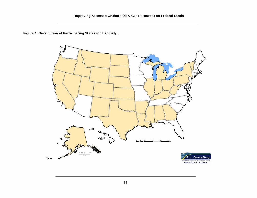
citizens action groups from many states. The map in Figure 4 highlights the states in
which research has been conducted for this project. The following are a list of some of
the topics researched and presented in this document:
• Onshore Oil and Gas Overview: The researchers examined non-regulatory and
regulatory guidance documents as well as industry personnel to identify
characteristics of standard onshore oil and gas development. This section is
intended to provide readers a familiarity with the phases and practices within the
various types of oil and gas development in the United States. Researchers
examined several existing documents pertaining to onshore oil and gas
production processes include leasing, environmental consequences from the
phases of exploration, construction, production, abandonment, and reclamation.
Documents pertaining to specific resource elements were studied to determine

Improving Access to Onshore Oil & Gas Resources on Federal Lands
10
techniques that are used for predicting environmental consequences from
activities relating to oil and gas development.
• Existing Regulations: Researchers examined the applicable and relevant
regulatory literature as it applies to onshore oil and gas exploration and
production sites for environmental assessment of oil and gas projects. The main
focus of the regulatory research was NEPA which necessitates the environmental
impact assessment process. In addition, land management regulations were
studied from several government agencies including the BLM, the USDA Forest
Service, and the US Fish and Wildlife Service.
• Management Practices: Researchers examined Management Practice (MP)
documents from several existing federal agencies. These included Resource
Management Plans (RMPs) and land use management plans; both programmatic
and project specific. Such guides provide information on regional specific
resources that affect oil and gas development and what practices are used to
monitor and mitigate the environmental consequences of a project. The
documents also provided information regarding the changes that have occurred
to the level of detail included in the management practices identified in these
documents.
• Review of Environmental Impact Assessment Documents: Numerous
Environmental Impact Statements and Environmental Assessments were
reviewed by researchers. In reviewing these documents the level of detail within
each analysis as well as the myriad of different methods applicable to oil and gas
development impacts were assessed. Documents from around the United States
were reviewed to highlight regional variations in the assessment process, the
most appropriate of which were included in this document for the purpose of
creating a set of universally applicable methods for assessment.
• Case Studies: Two case studies were conducted. The Swanson River Oil & Gas
Field case study took place in Kenai Peninsula Borough, Soldotna, Alaska. The
Swanson River case study provides a historical perspective of federal land
management approaches, which are implemented by varying regulatory
agencies, to demonstrate conflicting agency objectives, as well as the
complexities that are often involved in managing oil and gas lands. The
objective of the Badger Hills Exploration and Production Area case study was to
Improving Access to Onshore Oil & Gas Resources on Federal Lands
11
Figure 4 Distribution of Participating States in this Study.

Improving Access to Onshore Oil & Gas Resources on Federal Lands
12
evaluate resource assessments and impact analysis by comparing the 2004
Badger Hills Environmental Assessment document to the analysis performed for
the Montana Statewide EIS. The evaluation assessed the difference in the
assessment methods of the EIS for comparison of statewide programmatic
analysis and the site specific analysis of an EA. The Swanson River case study is
presented in this document as Appendix A, while the Badger Hills case study is
presented as Appendix B.
D. PROJECT ADVISORY COUNCIL
The research herein was conducted under the direction of the Interstate Oil and Gas
Conservation Commission (IOGCC), with oversight and direction from a Project Advisory
Council (PAC). The PAC is comprised of a diverse group with interests related to federal
land management and oil and gas develop that includes: oil and gas agency directors,
state and federal agency representatives, industry representatives and other
stakeholders. Because the PAC includes such a diverse group, input was actively sought
during various stages of the research to provide direction for the research, and help in
identifying issues that are relevant to the success of the research. The diversity of the
PAC has resulted in the research obtaining unique perspectives into the issues of oil and
gas development and access of federal lands.
E. SUMMARY OF FUTURE RESEARCH AND OBJECTIVES (PHASE II)
Upon completion of the Phase I portion of this Project, as summarized in subsection C, a
system of SMART tools based on spatial data analysis will be developed to facilitate a
uniform approach for assessment of NEPA related resource impacts, as well as generate
predicted resource impact data that more accurately reflects observed actual impacts.
The development of these SMART tools will be based on data collected and analyzed
during the Phase I portion of this Project. The SMART tools will be further defined and
validated by assessing and comparing predicted and actual resource impact data
gathered for the Badger Hills case study. It is hoped this calibration technique will
sharpen the analysis to better forecast actual resource impacts and provide field tested
feedback to the research team to allow for identification of additional research needs

Improving Access to Onshore Oil & Gas Resources on Federal Lands
13
II. INTRODUCTION TO ONSHORE OIL & NATURAL GAS DEVELOPMENT
This section is intended to present concepts related to typical onshore oil and gas
development procedures relevant to federal land use planning and provide the user with
a basic knowledge of key concepts of oil and gas development and land use planning.
Fluid minerals are defined by the BLM as oil, natural gas and geothermal resources
(BLM, 2005b). The discussion included here focuses on oil and natural gas and excludes
reference to, or discussion of geothermal resources. Oil and natural gas are the primary
hydrocarbons used for energy and transportation needs within the United States.
Hydrocarbons are formed from organic matter altered deep within the earth’s crust
under slowly increased temperature, pressure and bacterial action. Over time the
organic matter is heated to the point where the organic matter is altered resulting in the
formation of oil and natural gas.
Within the United States there are 31 states with oil and natural gas production, with
the majority of production coming from Texas and Louisiana (including offshore
production). Figure 5 provides a comparison of relative energy production (measured in
Btu’s) from oil and gas by state for the year 2000. The data included in Figure 5
includes off-shore production from the Gulf of Mexico. The majority of oil and gas
production within the United States occurs in only a handful of states, with most states
having only minor production (Figure 5).
Figure 5 is a snap-shot of oil and gas production in the year 2000; of course production
is in a state of constant change with new wells being drilled, new fields being found, and
old fields depleting. Oil and gas production from the United States are both in a
condition of decline from historical highs. This decline is largely due to the depletion of
old, very large fields discovered years ago. Figure 6 illustrates the historical trend of
annual oil production and Figure 7 illustrates the historical trend of natural gas from the
nation’s gas producing wells.

Improving Access to Onshore Oil & Gas Resources on Federal Lands
14
Figure 5 Oil and Gas Energy Production for the United States from the Year 2000.
Figure 6 Annual Oil and NGL Production Rates – 1935 to 2010; peak is reached in early 1970’s.
2006
Energy Production by State in the Year 2000 (Including Offshore Production)
0.000
1.000
2.000
3.000
4.000
5.000
6.000
7.000
8.000
Ala
bam
a
Ala
ska
Ariz
ona
Ark
ansa
s
Cal
iforn
ia
Col
orad
o
Flor
ida
Illin
ois
Indi
ana
Kans
as
Ken
tuck
y
Loui
sian
a
Mic
higa
n
Mis
siss
ippi
Mis
sour
i
Mon
tana
Neb
rask
a
Nev
ada
New
Mex
ico
New
Yor
k
Nor
th D
akot
a
Ohi
o
Okl
ahom
a
Ore
gon
Penn
sylv
ania
Sout
h D
akot
a
Tenn
esse
e
Texa
s
Uta
h
Virg
inia
Wes
t Virg
inia
Wyo
min
g
State
Ener
gy P
rodu
ctio
n (Q
uads
)
Crude OilNatural Gas

Improving Access to Onshore Oil & Gas Resources on Federal Lands
15
Figure 7 Annual Natural Gas Production Rates – 1930 through 2006 :peak is indicated at 1973.
U.S. Dry Natural Gas Production (MMcf)
Decade Year-0 Year-1 Year-2 Year-3 Year-4 Year-5 Year-6 Year-7 Year-8 Year-9
1930's 1,903,771 1,659,614 1,541,982 1,548,393 1,763,606 1,913,475 2,164,413 2,403,273 2,284,863 2,464,637
1940's 2,654,293 2,778,061 3,026,694 3,393,743 3,672,156 3,882,066 3,987,488 4,393,439 4,938,512 5,195,404
1950's 6,022,198 7,164,959 7,694,299 8,056,848 8,388,198 9,028,665 9,663,910 10,246,622 10,572,208 11,547,658
1960's 12,228,148 12,661,579 13,253,006 14,076,412 14,824,027 15,286,280 16,467,320 17,386,791 18,494,523 19,831,680
1970's 21,014,229 21,609,885 21,623,705 21,730,998 20,713,032 19,236,379 19,098,352 19,162,900 19,121,903 19,663,415
1980's 19,403,119 19,181,261 17,820,063 16,094,461 17,466,472 16,453,857 16,059,030 16,620,581 17,102,621 17,310,645
1990's 17,809,674 17,697,802 17,839,903 18,095,460 18,821,025 18,598,679 18,854,063 18,902,389 19,023,564 18,832,232
2000's 19,181,980 19,616,311 18,927,788 19,098,544 18,590,891 18,074,237 18,491,057
Source: U.S. Energy Information Administration
The implications of these two hydrocarbon production trends suggest that the oil and gas
industry will be forced to make up the increasing shortfall between growing demand and
shrinking domestic supply. The shortfall predicted by these trends is even worse than that
predicted by the USGS and shown in Figure 1. The shortfall can only be narrowed with
increased production or costly imports. Operators will be exposed to tremendous political and
economic pressures to accelerate exploration and development. Political pressure may be
sufficient to truncate or modify the NEPA process. Operators and federal land managers can
abate those pressures by utilizing some of the techniques outlined in this report.
Shortfall of natural gas may best be ameliorated by increasing development of tight gas, coal
bed natural gas, and other unconventional resources. The EIA forecasts unconventional gas to
grow in percentage of total gas production from 28 percent in 2003 to 36 percent in 2025 (EIA,
2003) (“EIA’s natural Gas Outlook Through 2025”, Aug 7, 2003). Unconventional gas resources
frequently demand large numbers of wells and more intense infra-structure that can constrain
access to certain federally controlled land areas. Actions that could help overcome these

Improving Access to Onshore Oil & Gas Resources on Federal Lands
16
constraints include in-depth environmental assessments that focus on the most significant
constraints; the development of environmentally enhanced exploration and production
technologies, such as low emission motors; the creative use of more environmentally sensitive
water treatment and disposal methods; and minimization of the drilling footprint through use of
single drilling pads with multiple, directional wells (EIA, 2002)(“ Impact of Unconventional Gas
Technology in the Annual Energy Outlook 2000”, July 30, 2002).
The oil and gas producing regions within the United States are shown Figure 8. This figure
illustrates that oil and natural production occurring within the United States occurs in relatively
discrete regions. From Figure 8 the major production areas for oil and gas of the United States
can be identified; these areas include the Gulf Coast, upper Appalachian Mountains, Mid-
Continent, and the Rocky Mountain areas. Across these regions are inherent similarities in the
way in which oil and natural gas are developed. The following discussion presents a discussion
of the oil and gas development process, with a focus on development activities on federal lands.
A. HISTORY AND EVOLUTION OF THE ONSHORE OIL AND GAS INDUSTRY
The oil and gas industry in the United States started with the earliest explorers who discovered
petroleum deposits of various types near the surface as early as the 16th century (Wall, 2005).
Oil and natural gas drilling and production have progressed since the latter half of the 19th
Century. Technology has progressed by steps from shallow impact drilling to carefully control
rotary drilling at precise angles and steering to tiny geographic targets. Drilling controls have
allowed operators to protect every aspect of the environment while producing as much of the
hydrocarbon resource as possible.
History
Early discoveries of oil resulted in settlers adapting oil to uses including medicine, grease for
tools, and kerosene derived from distilled rock oil. By the late 19th century, the rock oil industry
of the United States was overtaking the whale oil market; the oil production and refining market
was growing at such a rate that the price of oil dropped considerably. The first oil company
was formed in Pennsylvania in the 1850’s which resulted in the first known oil production from a
drilled well to the source (Wall, 2005). The initial oil boom in Pennsylvania resulted in
Rockefeller interests in oil refining and led to the formation of the Standard Oil Company.
Standard Oil Company led the industry with the formation of some of the earliest research and
development programs which improved the quality of the kerosene making it more reliable,
efficient and economic than most other fuels.

Improving Access to Onshore Oil & Gas Resources on Federal Lands
17
Figure 8 Oil and Natural Gas Producing Regions in the United States.
Map showing production regions by resource within the United States and the Gulf of Mexico

Improving Access to Onshore Oil & Gas Resources on Federal Lands
18
As additional discoveries of oil occurred in the west (California), in Texas, and parts of
the Midwest around the start of the 20th century, the competition for Standard Oil
Company grew and oil production from the United States was equal to that of the rest of
the world (Wall, 2005). The growth of Standard Oil Company had also resulted in other
changes to the economy and business regulations of the United States including the
regulation of railroads and antitrust regulations. In 1911 the United States Supreme
Court declared Standard Trust a monopoly and forced the trust to dissolve, resulting in
the formation of smaller companies that handled the production and refining of oil under
separate companies (Wall, 2005).
The invention of the internal combustion engine, the automobile, and airplanes all came
as greater discoveries of oil were occurring across the United States (Wall, 2005). With
World War I and World War II came the need for the United States to supply oil for the
war effort forcing oil companies to work together. In turn, after WWI the American
Petroleum Institute was formed. Since World War II, oil has become one of the primary
issues in conflicts in the rest of the world, and increasingly America’s reliance on oil has
affected the nation’s foreign policy.
Evolution of Oil and Gas Drilling and Production Activities
The oil and gas industry has evolved considerably since the first oil production from a
well in Pennsylvania in the 1850’s. Exploration and development equipment has
changed as new technology has been developed to allow for deeper exploration, faster
and more precise drilling, and the ability to directional drill. Production activities have
changed with advances in oil water separation (down-hole oil water separators), pipeline
materials, and surface pumps.
The earliest oil and gas exploration activities in the United States were chance
encounters with oil or gas seeps at the ground surface by America’s earliest explorers.
Over time, exploration activities became more and more focused on looking for surface
characteristics that were believed to be reflective of subsurface conditions, geologists
discovered that anticlinal structures had a greater chance of containing hydrocarbons
(NaturalGas.org, 2005). Almost 70 years after the invention of the seismograph for the
detection of earthquakes, the technology was applied to oil and gas exploration to aid in
the location of potential oil containing formations in the subsurface. Seismic exploration
has evolved from using explosives to generate the seismic waves to the use of heavy
commercial seismic vibrator trucks. The data compilation for seismic activities has
Improving Access to Onshore Oil & Gas Resources on Federal Lands
19
become increasing more complex with the advent of more technologically advanced
geophones, recording trucks, and three-dimensional computer modeling. The
information acquired prior to drilling the first “wildcat” well in a new area far surpasses
the information from 15 years ago.
Drilling of onshore oil and gas wells has also evolved considerably in recent history. In
the early 20th century, oil and gas drilling was performed using a cable-tool drilling rig in
which the vertical movement of a “chisel-like” drilling bit was suspended from a cable
that was raised and lowered to chip away at the rock (EPA, 1987). The advent and
advancement of rotary drilling technology in the 1910’s resulted in the eventual replaced
cable-tool drilling techniques in the United States. Rotary drilling techniques allowed for
deeper drilling, greater control of high pressure downhole conditions, and the removal of
drill cuttings during drilling. Additional advances in drill bit technology, drilling fluids,
drill pipe, and electronics have resulted in more precise and faster drilling, eventually
leading to the development of horizontal or directional drilling which is becoming
increasing more common in today’s development of oil and gas resources. Horizontal
drilling has allowed for increased recovery of oil and gas resources from older fields,
development of previously identified marginal oil and gas plays, and reduced surface
disturbances since spacing can be greater than traditional boreholes and multiple
boreholes are possible from one pad site. Drilling technology is still evolving with
multilateral drilling becoming more common, and slimhole drilling making recent
advances in reducing the volume of cuttings produced from drilling (API, 2006).
Difficulties Encountered in Leasing Impaired Lands without Historical Oil and Gas Development
In general, the regional development of oil and gas on public lands can be summarized
under three distinctive scenarios, each having the potential to affect the overall NEPA
process in varying manners, e.g., impact analysis, public involvement or level of
concern, process duration, etc. These scenarios include:
• An area with existing oil or gas production at, or within, a reasonable proximity
of the lease.

Improving Access to Onshore Oil & Gas Resources on Federal Lands
20
• An area where oil or gas production may not have a history in the region, but
which has had a history of previous uses such as ranching, logging, recreational
use, etc. (Under this scenario and for the purpose of this study, such land uses
are considered to have created an existing degree of environmental impairment
such as road construction, habitat fragmentation, degradation of water quality,
etc., from sources other than previous oil and gas development.)
• An area which is essentially pristine with no previous oil or gas history and no
history of prior activities that would have in any way adversely affected the land.
Intuitively it would be expected that authorization for oil and gas development on lands
defined as pristine, or those lands containing no previous oil and gas development,
would be much more complex and thus, more time consuming throughout the NEPA
evaluation, leasing, and APD process than would be the situation under the first
scenario; more difficult not only from a public opposition standpoint, but also more
difficult from a regulatory perspective because of the greater likelihood of threatened
and endangered species, presence of sensitive habitats, traditional cultural properties,
potential to introduce noxious weeds or other invasive plant species, visual resource
classification, roadless designation, etc. which would complicate the NEPA process.
Interviews with BLM personnel indicate (L. Ricci personal communication, 2006) there is
no fundamental difference in the difficulty since the governing regulations are one-in-
the-same for each scenario, assuming these lands are not managed for conservation or
protection (e.g., wilderness areas, wildlife refuges, etc.). Other BLM personnel (L.
Harrison and D. Judice, personal communication) and State Oil and Gas Agency
personnel (D. Likwartz, personal communication) indicated that areas where oil and gas
development has no prior history may be more difficult to permit.
The question then revolves around the second scenario: is it more difficult to permit
areas with no previous oil or gas history (than it is to permit an area where oil or gas
production has a history or is established within the region), even if that land has
suffered previous impairment from historical activities such as ranching, agriculture,
logging, etc.? It appears that this may in fact be the case since current lands proposed
for oil and gas drilling under this scenario are becoming exceedingly more difficult to
develop because of increasing opposition by the public and/or environmental special
interest groups.

Improving Access to Onshore Oil & Gas Resources on Federal Lands
21
An example of this is provided by Blackleaf Canyon, which is located on the Rocky
Mountain Front near Choteau, Montana. Blackleaf Canyon and the Rocky Mountain
Front in general, are areas with high species diversity and ecological uniqueness that
provides habitat for certain threatened and endangered species such as grizzly bears.
For this reason, public concern and opposition to oil and gas development in the area
has steadily increased.
Oil and gas development within Blackleaf Canyon has essentially been prevented as a
result of public opposition. For instance, access across private surface ownership to
nearby federal leases has been denied to a point that necessary re-route distances to
access the federal leases would have become impractical for operators. Construction of
access roads to circumvent privately held lands would require longer road corridors, thus
causing additional surface disturbance, as well as greater impacts to other NEPA
evaluated environmental resources. The overall public opposition to drilling at Blackleaf
Canyon is well organized at both the local individual and regional/national environmental
special interest group levels which are vehemently opposed to oil and gas development.
Because of this, future oil and gas exploration opportunity in the Blackleaf Canyon area
has presently been precluded from further oil and gas development consideration
despite a long history of oil and gas activity within the area.
Interestingly, the BLM has chosen to reallocate its Blackleaf resources to the West
HiLine area where historic oil and gas production is more established. The West HiLine
area includes existing oil and gas development within and proximal to the Upper
Missouri River Breaks National Monument (there are producing wells on the Monument
that pre-date proclamation of the Monument). West HiLine involves a greater number
of leases to let and a larger pool of potentially interested operators than did Blackleaf
Canyon, as well as existing production in the area. As a result, West HiLine appears to
represent an area where leasing and production may be more easily permitable, despite
proximity to the National Monument.
According to BLM personnel interviewed (C. Trent and D. Judice, personal
communication 2006); the West HiLine area has had previous impairment in the form of
a long history of ranching and agricultural use as well as some limited areas of logging.
There is also existing oil and gas production in the area, but a newly updated RMP for
the area has not yet been through the scoping stage so unknown challenges may
confront future development. According to the MBOGC, private mineral estate acreage

Improving Access to Onshore Oil & Gas Resources on Federal Lands
22
in this area is currently being developed, but the lack of a completed RMP is postponing
development of federal mineral estate tracts. MBOGC also pointed out that despite the
presence of proven reserves, new leasing within the Monument is precluded because of
its designation. Two separate BLM studies: the Upper Missouri River Breaks National
Monument RMP and the Oil and Gas Issues In and Adjacent to the Upper Missouri River
Breaks National Monument are currently in progress to evaluate the Monument area.
The three land/mineral estate scenarios outlined above primarily address the mineral
estate side of the equation. In fact, in the NEPA process one could also distill the
associated issues into three categories or “levels of concern” (J. Majerus, personal
communication 2006):
1 – Properties with minimal resource and social issues.
2 – Properties with moderate resource and social issues.
3 – Properties with highly complex and/or controversial resource and social issues.
Blackleaf Canyon falls within category 3 of this spectrum. At Blackleaf Canyon there
were significant resource issues (threatened and endangered species and winter habitat
in particular), significant cultural issues (Native American Traditional Cultural Sites),
significant visual resource issues (the intrinsic beauty of the area), and significant social
issues (a high level of public resistance to oil and gas development).
In practice, the three land scenarios and the three issue categories interweave into a
complex multi-dimensional matrix. Any given property then falls somewhere within that
matrix and one can realistically conclude that the more complex the issues, the more
time consuming and challenging the NEPA and APD process will be whether it be driven
by regulatory, environmental, or public concerns.
In summary, while the Blackleaf Canyon example involved complex, multidimensional
issues, it does appear that the full cycle process of NEPA review, leasing, exploration,
and development can indeed be more difficult and/or time consuming in areas where oil
and gas are not already established facets of the economic landscape despite these
same lands having suffered previous environmental impairment.
Increase in Environmental Awareness
As oil and gas development and drilling progressed, states with oil and gas production
have developed regulations relevant to the oil and gas industry. Early oil and gas
regulations focused on proration of oil production, an effort intended to avoid the waste

Improving Access to Onshore Oil & Gas Resources on Federal Lands
23
of oil resources because production was outpacing transportation capabilities (OCC
2006). The focus of regulations has evolved now to address more emphasis on public
safety and protection of the environment; air, water, and soil. Regulations in states
such as Ohio, Texas, and Oklahoma helped in forming the federal regulations written by
the US EPA in the 1970’s. Federal regulations contributed to the industry lobbing for
making regulations equitable from state to state, so that oil and gas operators could do
business around the country and know that regulations are commensurate and
correlative.
Awareness in global climatic change or “global warming” continues to be a highly prolific
subject, which is causing considerable controversy among politicians, oil and gas
stakeholders and public citizen groups. Support of the global warming theory appears
to be growing as new scientific research and data gathering efforts indicate warming
trends in the earth’s atmosphere are likely being enhanced due to anthropogenic
causes. Energy-related carbon dioxide emissions, resulting from petroleum and natural
gas, represent 82 percent of total U.S. human-made greenhouse gas emissions
(National Energy Information Center, 2007). In addition, the U.S. produces about 25
percent of global carbon dioxide emissions from burning fossil fuels; primarily because
the U.S. economy is the largest in the world and 85 percent of the Country’s energy
needs come from the burning of fossil fuels (National Energy Information Center, 2007).
As such, public demands for the lowering of greenhouse emmisons are at the forefront
within many political arenas. Consequently, it can be expected that potential legislation
in the near future aimed at curtailing fossil fuel emissions will likely present the oil & gas
industry with a quandary of regulatory and legal hurdles that may further hinder future
exploration and development projects.
Many chemical constituents that occupy the Earth’s atmosphere act as “greenhouse
gases.” Some of them occur in nature (water vapor, carbon dioxide, methane, and
nitrous oxide), while others are exclusively human-made (like gases used for aerosols).
When sunlight strikes the Earth’s surface, some of it is reflected back towards space as
infrared radiation (heat). Greenhouse gases absorb this infrared radiation and trap the
heat in the atmosphere. The greenhouse theory revolves around the premise that
disproportional concentrations of energy are not being radiated back into space, which is
thus leading to an increase to the earth’s surface temperature. However, given the
natural variability of the Earth’s climate, it is difficult to determine the extent of change
that humans may have caused (National Energy Information Center, 2007).
Improving Access to Onshore Oil & Gas Resources on Federal Lands
24
Industrial nations rely on the use of fossil fuels to warm and cool homes and businesses,
as well as provide ingredients for medicines, fertilizers, fabrics, plastics and other
products. Because of this reliance, the use of fossil fuels is likely to continue for many
years. The question then arises: how to effectively balance the United State’s and other
industrial nation’s energy needs with the conservation and protection of critical
resources needed to sustain natural conditions.
To begin with, current trends in the oil & gas industry involve close management of their
own energy use. For example, one conservation strategy uses heat and power
technology that is able to convert waste heat into energy, reducing energy consumption
and emissions (API, 2007). The aim of this technology is to reduce emissions by 10
percent between 2002 and 2012. In addition, geological carbon sequestration to
enhance oil recovery as well as remove carbon dioxide from the atmosphere has
received considerable attention. The ideal carbon sequestration “project” would include
a carbon dioxide source (i.e. coal fired gas plant) in close proximity to a carbon sink (i.e.
aging oil and/or gas field). The United States Department of Energy estimates that 89
billion barrels could be added through CO2 enhanced recovery, over four times the
current proven reserves (DOE, 2006b). The dual benefit of enhancing oil and gas
recovery and managing greenhouse gas emissions will likely continue to push the use
carbon sequestration, both on private and public leases. The most recent data from the
U.S. Energy Information Administration show that CO2 greenhouse emissions from U.S.
industry, including oil and natural gas companies, have declined and were actually below
1990 levels (2007).
The oil & gas industry is also lowering greenhouse emissions by leading research efforts
on alternative energy use, including solar power, biofuels, geothermal energy, and wind
power. Furthermore, industry leaders are working with the automakers and government
agencies on new fuel/vehicle technology such as fuel cells and hydrogen power;
reducing natural gas flaring to cut emissions; storing CO2 underground, where it can be
safely held for thousands of years; and implementing new emissions estimation and
tracking tools to enable it to assess how well it is meeting the goals it has set for itself
and report progress to the public (API, 2007). Because of these efforts the U.S. is
projected to lower its carbon intensity by 25 percent from 2001 to 2025, and remain
below the world average (API, 2007).

Improving Access to Onshore Oil & Gas Resources on Federal Lands
25
B. THE PROCESS OF ONSHORE OIL AND GAS DEVELOPMENT
Federal on-shore oil and gas regulations occur in three stages: planning, leasing, and
development (NPS, 2003). The planning stage includes the development of Resource
Management Plans, which are the guidance documents the BLM prepares to govern the
development of oil and gas resources as well as other resources within designated
planning areas. RMPs outline the uses and methods of development for federal minerals
and surface estate and are required by the Federal Land Policy and Management Act.
RMPs also identified lease stipulations and variances and explain how and when these
should be applied. Generally, it is during the planning stage that the BLM and surface
management agency’s determine which public lands should be made available for oil
and gas leasing. The leasing stage is when BLM offers the public lands identified during
the planning stage to the public for lease. The development stage is when BLM
monitors the oil and gas development actions to ensure that lease stipulations are being
met. The activities associated with the operations of onshore oil and gas development
can be divided into a sequence of events that occur in phases as a project progresses
from exploration to development. These can include the following five phases: leasing,
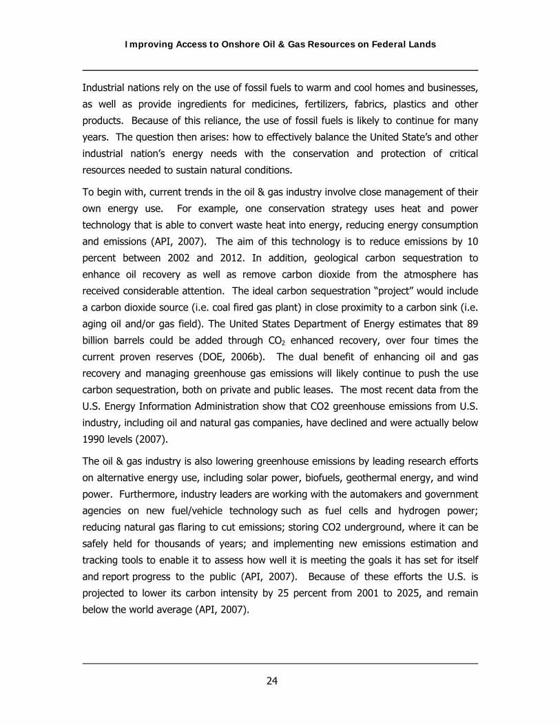
exploration, development/construction, production, and final reclamation. Figure 9
presents a sequential breakdown of activities that occur in the development of oil and
gas fields providing information on each of the phases of oil and gas development as
well as the preliminary investigations.
Leasing
An oil and gas lease is a legal right granted to an operator (the lessee) to access leased
lands for the purpose of exploring, drilling, extracting, removing, and disposing of oil
and gas deposits (except helium) found in leased lands (BLM, 2004a). The BLM was
assigned the responsibility for oil and gas leasing of minerals owned by the Federal
Government in the Mineral Leasing Act of 1920, the Mineral Leasing Act for Acquired
Lands of 1947, the Federal Oil and Gas Royalty Management Act of 1982, and the
subsequent amendments to these Acts (BLM, 2004a). Public lands are only made
available for oil and gas leasing after the BLM has assessed the lands using their
multiple-use planning process (BLM, 2004a). The leasing decisions made by BLM have
become increasingly challenged as issues regarding the required level of analysis under
NEPA have been raised in federal courts. The issues raised involve whether an
Environmental Assessment is sufficient at the time of leasing or if an Environmental

Improving Access to Onshore Oil & Gas Resources on Federal Lands
26
Impact Statement is necessary before public lands can be offered at oil and gas lease
sales (NPS, 2003).
The EIS process requires the lead agency to identify a reasonably foreseeable
development scenario that describes the predicted level of development that is expected
to occur on the identified public lands. In some instances, when making public lands
available for oil and gas leasing it is not always possible to predict accurately the level of
development that would be expected to occur in the future; thus, development of an
EIS would be difficult in the early stages. However, the issuance of an oil and gas lease
results in the BLM being compensable for the property right interest of that lease should
the BLM decide not to allow development of that lease when an Application for Permit to
Drill (APD) has been submitted (NPS, 2003). Leases issued on federal lands contain a
lease notice which identifies the terms of the lease; these terms set conditions to which
the operator must uphold to remain in good standing. A lease notice provides the
lessee with information on the limitations that have been placed on a leased property
based on law, lease terms, regulations, or operational orders (BLM, 2003b). Oil and gas
leases on federal minerals incorporate federal environmental regulations into the
standard terms, but federal leases can also include additional terms that require
additional mitigation measures to minimize environmental impacts.
The BLM offers two types of oil and gas leases for public lands: competitive and non-
competitive (BLM, 2004a). Oil and gas leases must first be offered at a competitive
lease auction. If the leases do not received a bid then the leases are made available as
noncompetitive leases starting the first business day after the competitive bid auction.
The size of a lease is established by the BLM prior to offering the lease for auction.
Competitive leases are limited to 2,560 acres in the lower 48 states and to 5,760 acres
in Alaska; noncompetitive leases are limited to 10,240 acres in all states. Leases are
issued for a 10-year period and automatically continue as long as oil or gas is being
produced in paying quantities and the terms of the lease are being met.
Improving Access to Onshore Oil & Gas Resources on Federal Lands
27
Figure 9 Summary of the Phases of Oil and Gas Development

Improving Access to Onshore Oil & Gas Resources on Federal Lands
28
Exploration Phase
After a lease has been obtained and before an operator can begin drilling or other
surface disturbing activities for an exploratory or wildcat well, the operator must post
the lease bond and file an APD or Notice of Staking. The BLM must then perform the
necessary assessment of potential impacts by completing either an Environmental
Assessment or an Environmental Impact Statement prior to approval of the APD. The
operator must specify in the APD information relative to the type of oil and gas well and
depth of the targeted exploration zone. This information is used by the operator to
determine the equipment and access needed to drill the exploratory well, and is used by
the BLM to fulfill the necessary environmental evaluation obligations (NPS, 2003). The
construction activities for an exploration well typically include a roadway and drill pad.
These areas must be staked or flagged prior to the BLM field inspection, which is part of
the APD approval process.
The size of access roads and drill pads for exploratory wells vary based on the depth of
the target exploration zone. Shallow exploratory wells (500 to 2,000 feet) may require a
simple bladed road to clear brush and allow access for a short time period (typically a
few days); deep exploratory wells (5,000+ feet) may require the construction of a
higher standard crown and ditched gravel roads as drilling may take a month to drill and
require considerable heavy truck traffic (MBOGC, 1989). The size and type of drill rig
necessary to drill a well is determined by the depth of target zone. Shallow CBNG wells
in the Powder River Basin of Wyoming and Montana can be drilled with water well rigs,
while deep oil and gas wells in most of the producing areas are drilled with double or
triple derrick rigs. The drill rig selected is then used to determine the properties of the
access road and size of the drill pad; water well rigs can use drill pads as small as ½
acre or less, while double or triple derrick rigs may require 3 acre or larger drill pads
(MBOGC, 1989). The deeper wells and larger drill rigs require more materials including
mud tanks, reserve pits, produced water storage, oil and gas storage tanks, pipe racks,
and crew parking for the drill pad contributing to the need for a larger staging area.
The construction of access roads is also based on the drill rig. Some of the smaller rigs
can use bladed roads with a typical width of about 10 feet while larger rigs can require
24 feet wide graveled, crowned and ditched road.
After the drilling site has been inspected by the BLM and the APD approved and access
roads and the drill pad constructed, exploratory drilling activities can be initiated by the

Improving Access to Onshore Oil & Gas Resources on Federal Lands
29
operator or the operator’s contracted driller. An oil and gas well is typically drilled in
three phases; the pilot hole is spudded using a large diameter auger bit, the drill rig
then drills the surface hole in which a surface casing is set, and then the production hole
is drilled. After the pilot hole is drilled large diameter casing (a 24 inch to 36 inch
conductor pipe) is set and cemented, then the surface hole is drilled and a second
casing is cemented in place to isolate the rest of the drilling operations from fresh water
aquifers and supply sufficient pressure protection for the production drilling.
While drilling the well, testing may be conducted when potentially production zones are
encountered. Typical oil and gas well testing is conducted through the drill stem when a
productive interval is believed to be encountered. Tests are typically performed by a
contractor hired by the operator with an operator’s representative present to supervise
(MBOGC, 1989). In addition to production testing through the drill tubing, once the well
is drilled to depth, a series of well log tests are typically performed by a well logging
contractor. After the tests, the operator makes the decision to either complete the well
or plug the borehole.
If testing indicates the well might produce commercial quantities of oil or gas, the well is
completed by running production casing into the borehole. The type of completion
performed on a well will vary depending on type, depth, operator, and the
characteristics of the producing formation. In some instances, casing is run to the depth
of the production zone then casing is set and cemented from the bottom to a point
above the production or pay zone (MBOGC, 1989). Once the casing is set and the
cement has been given the appropriate time to cure, the casing is perforated based on
the information collected from the tests, in particular, the data from the well logs. In
other instance, a well may be completed as an open hole, in which case, drilling stops at
the top of the producing formation, casing is set and cemented, and then the producing
zone is drilled. An open hole completion allows a greater area to be exposed for
potential production, but at the same time reduces the operators ability to control the
amount of water produced (MBOGC, 1989). Once the production casing is set, tubing
and a pump (as needed) are placed in the well and the wellhead is installed at the
surface. The well is then tested for a period of time before permanent production
equipment is brought onto the site; the period will vary based on the operator and the
well characteristics.

Improving Access to Onshore Oil & Gas Resources on Federal Lands
30
Development/Construction Phase
Once the exploration phase has been completed and a producing zone has been
identified, the operator begins to plan for the development phase of a project. The
development phase of the project involves the operator increasing from a single well to
multiple wells and associated access roads and production equipment. Production well
spacing would need to be established by the state oil and gas agency and the BLM, as it
is sometimes necessary to increase well spacing from the exploration requirements for
optimal production of the oil and gas resource from the reservoir. The operator
completes and submits APDs for each of the proposed production wells, identifies their
location and access routes, as well as identify the locations of production facilities such
as tank batteries, produced water management facilities, and pipelines and utility routes.
In comparison, a field that produces primarily oil would require more production
equipment than a field that primarily produces gas (MBOGC, 1989).
Once the operator has approval of the locations and drilling permits from the BLM, the
operator will begin construction operations. Construction activities begin much like
exploration activities with the construction of access roadways and well pads. However,
during these construction activities, additional infrastructure may also be included such
as installing power lines, pipelines, and production facilities; therefore, the quality of
roads constructed may be higher than during the exploration phase commensurate with
the increased level of traffic the roadways are expected to be able to handle for
production. Some roadways may remain as simple two track trails to the well locations,
while graveled, crowned and ditched roads may be constructed for the main road
through the field (MBOGC, 1989). Depending on the lease stipulations the operator may
be limited to certain types of production equipment such as buried utility lines instead of
overhead power lines, or cavitation pumps as opposed to pumpjacks. There may be
additional limitations set which only allow the operator to perform construction activities
during certain times of the year. Lease stipulations can result in less disturbed surface
acres from construction activities, but at the same time may limit an operator’s choices
of equipment or delay a project if the timing of APD submittals/approvals conflict with
timing of lease stipulations set for wildlife breeding seasons or rearing activities. Other
construction related limitations may be imposed depending on the surface management
agency or private landowner requirements for a construction project.

Improving Access to Onshore Oil & Gas Resources on Federal Lands
31
Some federal mineral estates can be located under surface estates administered or
managed by federal agencies other than the BLM, in these cases the operator may be
subject to varying mitigation measures. BLM and US Forest Service managed lands will
have strict requirements for the controlling of noxious weeds. As a remedy to control
the spread of noxious weeds, the BLM and US Forest Service have special seed mixtures
to help reestablish local plants; operators are required to use these mixes during
reclamation activities. For most surface disturbing activities associated with the
construction phase, project operators are utilizing active remediation practices to keep
impacts to a minimum. Examples of active remediation include the stockpiling of soils
and infilling of utility trenches as soon as the lines are placed in the trench, and the
reseeding of portions of the well pad once drilling is completed.
Production Phase
The production phase starts when the operator receives approval from the BLM or state
oil and gas agency to start production. Early in the production phase, onsite activities
are usually limited to monitoring of equipment and production, maintenance of
equipment, and disposal of production wastes. There is generally a field hand that is
scheduled to perform routine monitoring and maintenance activities; this may be
conducted as frequently as daily or weekly depending on the size of the field. The BLM
estimates that an additional annual production job (pumpers, workover crew, water
haulers, rig repair, etc) is created for approximately every 18 wells in production for any
given year (BLM, 2006b). Put simply, for a field with 1,800 producing wells,
approximately 100 qualified workers would be needed to properly run and maintain the
field. The population pressure caused by this demand for qualified workers in the oil and
gas industry can last for several years during production, and this may be overwhelming
to the existing local community as demands for schools, infrastructure, and housing can
quickly outpace the growth of the community. These socioeconomic impacts to a
community are discussed in more detail in Section VI.D.
While population growth is to be expected due to the need for man-power to run the
field during production, technological advances are being made to make fields more
efficient through remote monitoring equipment. The location and type of equipment
used to monitor production activities varies depending on the type of the well, location
of the nearest sales point or main gas line, and can be influenced by mineral ownership.
Production from oil and gas wells is monitored from individual leases if production is

Improving Access to Onshore Oil & Gas Resources on Federal Lands
32
gathered into a central processing facility and the field has not been unitized, i.e.,
production is not shared by all lease owners (MBOGC, 1989).
Produced water management is necessary for most oil wells and some gas wells, as
wells will typically produced some water along with the oil and gas. Produced water
varies in quality and quantity - the two principal factors which govern how the water is
managed. Variations in produced water can range from fresh water near, or at, drinking
water quality, to saline brines with total dissolved solids at concentrations 10 times
greater than seawater. Management of produced water can be handled in a variety of
means and there are numerous reports which discuss produced water management for
the oil and gas industry (Argonne National Laboratory, 2004; ALL Consulting, 2003a, ALL
Consulting, 2005). A few examples of how water is managed include:
• High quality water can be managed through discharge where it can be
permitted;
• Low quantities of water can be managed in impoundments through evaporation;
and
• Injection is a common means of disposal for large quantities and/or poor quality
water. The water is typically injected into non-productive disposal zones (Class
II Disposal) or productive zones as part of an enhanced recovery operation
(Class II Recovery).
Enhanced recovery of oil generally occurs when the production rates of oil from a
reservoir start to decrease as a result of declining reservoir pressure. Initial production
activities which use gas or water pressure from the reservoir for production usually only
produce 20 to 25 percent of the oil in place (MBOGC, 1989). An enhanced recovery
phase is utilized to try and produce an additional 10 to 20 percent of the in-place oil. A
secondary or tertiary recovery effort is employed if it is economically feasible.
Secondary and tertiary recovery projects involve waterfloods, carbon dioxide (CO2) or
other chemical injections into the reservoirs in order to maintain or enhance reservoir
pressures so that additional oil can be produced. Enhanced recovery projects are also
influenced by the characteristics of the reservoir as some strata are less conducive to
the successful injection of fluids to promote the recovery of oil.
The injection of CO2, also known as geological carbon sequestration, has received a
considerable amount of attention in recent years due to the ability of carbon

Improving Access to Onshore Oil & Gas Resources on Federal Lands
33
sequestration to enhance oil recovery as well as remove carbon dioxide from the
atmosphere, which has been linked to global climate changes as a greenhouse gas. The
ideal carbon sequestration “project” would include a carbon dioxide source (i.e. coal
fired gas plant) in close proximity to a carbon sink (i.e. aging oil and/or gas field). The
United States Department of Energy estimates that 89 billion barrels could be added
through CO2 enhanced recovery, over four times the current proven reserves (DOE,
2006b). The dual benefit of enhancing oil and gas recovery and managing greenhouse
gas emissions will likely continue to push the use carbon sequestration, both on private
and public leases.
Maintenance activities can range from fixing surface equipment leaks or mechanical
failures to well workovers and well stimulations. Simple repairs are usually handled by
field hands who either work for the operator or are contractors to the operator that
handle the small day to day maintenance activities. Well workovers or well stimulation
work is generally handled by contracted agents of the operator who specialize in that
specific activity.
Reclamation Phase
Reclamation activities occur continually throughout the phases of an oil and gas
development project, with operators actively reclaiming temporary surface disturbances
during the construction phase and performing final reclamation after production has
ceased. Well plugging is one of the ongoing reclamation activities that can occur
throughout a project from the exploration phase through the end of production. Wells
are plugged in a variety of ways depending on the status of the well at the time of
plugging, i.e. production wells are plugged differently than dry exploration wells.
Generally, the plugging activities are intended to isolate potentially productive zones
from brine-filled zones and to isolate and protect underground sources of drinking water
(USDW). Therefore, cement and mechanical plugs are typically set at various intervals
defined by the depth of the well, material type, and managing agency regulations.
Generally, the plugs are set in a well at top and bottom of the surface casing, the
surface plug is set between the surface casing and the production casing, and bridge
plug is set at the base of the surface casing.
Surface reclamation of the wellsite and other facilities generally involves the removal of
production equipment, backfilling of pits, reseeding of denuded areas, flowlines may be
removed or abandoned in place, and the land surface restored to pre-development

Improving Access to Onshore Oil & Gas Resources on Federal Lands
34
conditions. Unless the surface management agency or private surface owner specify
otherwise, all oil and gas related materials are removed from the site and the land
surface is restored according to the stipulation attached to the lease including reseeding
the land for re-vegetation. After the reclamation has been initiated, managing agencies
will perform site inspections to document the changes made and identify any conditions
which need to be modified. Only after the site has been cleared by the managing
agency and the site deemed reclaimed by the agency are the sites removed from their
lease bonds.

Improving Access to Onshore Oil & Gas Resources on Federal Lands
35
III. REGIONAL ENVIRONMENTAL VARIATIONS
The United States contains more than 3,000,000 square miles of land surface, of which
approximately 30 percent is owned by the Federal Government (NEPDG, 2001).
Included is the expansive northern boreal forests in New England and Alaska; the dank
swampy wetlands of the southeastern states; the temperate rainforests of the
northwestern states; the arid deserts of the southwestern states; the grassland prairies
spanning the central plains; and prominent mountain ranges in the east and west. As
with state or privately owned lands, federally owned surfaces require varying
management strategies by responsible agency’s to provide reasonable protection of the
environment, while at the same time maintaining a regulatory process to assure public
or national needs are satisfied.
Federal managers must bear in mind their charge to establish multiple use strategies for
federal land and the most appropriate uses for that land. Land use will vary from tract
to tract based upon the past usage as well as the environmental resources of the tracts.
This section will deal with some of those resources and their variability that will affect
land management.
From an environmental assessment perspective, land management for oil and gas
development is further complicated by the complex and diverse array of regional or local
physical characteristics that can include habitat or community types, terrain, water
quality, wildlife, etc., which define any given land. Additionally, the importance of
protecting or conserving these characteristics differ from one region to the next, which
results in regional prioritization disparities in land management decisions. Thus,
methodology to assess oil and gas related environmental impacts on federally owned
lands must account for the heterogeneous and evolving environments of the United
States. These methodologies must also consider environmental resources which are
important to the local regulatory and public communities since the importance placed on
environmental resources often necessitates region specific approaches to land
management strategies.
It is apparent that regional or local settings pose unique challenges which make it
difficult for regulators and operators alike to uniformly assess environmental oil and gas
related impacts across the United States. Therefore, land management decisions and
the assessment of impacts from oil and gas development activities on federal lands that
are taken into account when making these decisions require the consideration of

Improving Access to Onshore Oil & Gas Resources on Federal Lands
36
characteristics specific to the local environment. These characteristics can include
regional variations in geology, climate, hydrology, biological features and surrounding
activities. The aim of this section is to discuss some of the environmental characteristics
which are pertinent to all phases of oil and gas operations and provide examples of how
these resources vary on a regional basis. By discussing the extent of regional
environmental variation in the United States, it is hoped that the need for regional land
management decisions is adequately illustrated so that future decision processes which
affect impact analysis on federal lands consists of more consistent and relevant
methodologies through each region. Although this discussion is not considered all
encompassing, it is intended to present information in a manner to allow for more
prudent decision making and to clarify why impact assessment methodologies should be
adapted to local conditions.
A. GEOLOGY
Recognizing and understanding the geologic variations which exist across the United
States on federal lands is fundamentally important during the planning and assessment
phases for oil and gas development projects. The physical and chemical characteristics
of the geology in a region dictate overall oil and gas production design and are
important elements in federal land management plans. A region’s geology can be
described by topography and soil type which determine potential erosion rates and
stormwater runoff velocities, and by stratigraphy and structure which are important
physical parameters in identifying the type of oil and gas reservoirs present and the
quality of oil and natural gas produced water.
Topography and soil types vary across the United States from mountains, plains,
deserts, plateaus and coastal lands. Topography and soil type figure in land
management analyses with the relative slope of an area used to estimate the potential
for surface impacts such as soil erosion or to identify areas that have the potential to be
impacted by stormwater runoff. The Independent Petroleum Association of America
(IPAA), in developing their guidance for Reasonable and Prudent Practices for
Stabilization (RAPPS) at oil and natural gas exploration and production sites, identified
separate regions of the country with similar characteristics based on slope, rainfall, soil
erodibility, as well as distance to surface water bodies and vegetative cover (Horizon
Environmental Services, Inc., 2004). Although the amount of precipitation that any
given region receives directly relates to the magnitude of potential erosion events and

Improving Access to Onshore Oil & Gas Resources on Federal Lands
37
E&P Construction Operations in Richland County, Montana (Photo by ALL Consulting)
runoff, typically areas characterized by steep slopes experience accelerated runoff
velocities, thereby having the potential to exacerbate erosion, especially when
vegetative cover is reduced during construction activities. Conversely, under the right
conditions topography can be utilized to reduce surface related impacts from runoff such
as well pads and produced water management structures (e.g., minimize the risk of
uncontrolled oil or brine spills and collect stormwater runoff) by using natural
topographic barriers to contain facilities and prevent erosion by controlling surface water
velocity.
Erosion rates from cropland in the United States for the year 1997, as published by the
United States Department of Agriculture, National Resource Conservation Service
(NRCS), averaged approximately 2.5 tons/acre/year. Technical resource figures
presented by the
NRCS indicate erosion
rates, to a certain
extent, are highest
along major
watersheds present
in Midwest and
Eastern states;
whereas low erosion
rates are more
common in Rocky
Mountain and
Pacific Coast states.
The affect erosion will have on a particular watershed or smaller water body will depend
on several factors that relate to the water system’s susceptibility to sedimentation and
include vegetative cover, runoff, volume, existing surface water quality and regional soil
types.
For example, in the context of erosion impact, soils are characterized by their erodibility,
which refers to the amount of energy needed to detach soil particles and facilitate
erosion. Soil texture affects the soils erodibility; soil particles that are large in size and
coarse in texture, such as sandy soils, generally tend to have the greatest erosion
potential; whereas, finer particles, such as silts and clays, tend to develop the attractive
force of cohesion as the surfaces of the aggregates rub together. Outcrop geology has

Improving Access to Onshore Oil & Gas Resources on Federal Lands
38
a major effect on soil type since bedrock is often the raw material for the development
of local soil types. This factor, as well as the aforementioned parameters, will require
integration into the assessment process to develop protective land management
strategies that make sense to land managers, the general public and regulatory
agencies.
It must be noted that the data used to extrapolate this information was not collected on
federal lands; data for the Rocky Mountain and Pacific Coast states is limited.
Additionally, this erosion data may leave a misleading impression as to the significance
of higher erosion rates in some areas where there is little cropland. However, for the
purpose of this document, the data does reflect moderate regional erosion variation,
which further illustrates the importance of assessing potential erosion impacts based on
regional or local physical parameters.
In many cases topography can also dictate hydrologic components of land management
and development (e.g., impoundments, water treatment facilities, and storm water
runoff) that, unless assessed correctly, may lead to additional soil erosion or
sedimentation problems. Steep slopes, deep, narrow valleys, and dissected uplands can
leave little room for flat wellsites or storage ponds. These elements of steep topography
are themselves direct evidence of the erodibility of the soil and bedrock. State
engineering offices or related agencies often provide specific construction guidelines for
storage impoundments, while in some states oil and gas agencies oversee small pits
related to oil and gas development. State guidelines dictate preventative elements in
the design that may include topographic restrictions (slope), water right permitting
requirements, flood spillway design and specific beneficial use limitations. In any case,
during the impact assessment phase for oil and gas related projects on federal lands,
the evaluation of regional or site specific topographic characteristics warrants certain
land management considerations regarding remediation so as to reduce unnecessary
resource impacts that may effectively delay or halt oil and gas operations.
The quality of produced water with oil and gas is a result of the interactions between
the rocks and water that occur in the subsurface over geological time. As such, water
quality can vary on a local scale as well as a regional scale. In the subsurface, water is
part of a dynamic rock-fluid system that contains hydrocarbons and water. After
sediments are laid down, subsequent movement of water and other fluids is largely
lateral, driven by hydraulic pressure differences. However, the net movement of water

Improving Access to Onshore Oil & Gas Resources on Federal Lands
39
is consistently towards the surface, driven by induration, compaction, and maturation of
the existing rock framework. As vertical movement continues, chemically active clay
minerals can impede the passage of dissolved constituents, thereby increasing the
salinity of the reservoir water. If upward migrating water has reduced salinity, the water
left behind will have higher salinity. This, in general, is what is observed in many
sedimentary basins, including the Anadarko Basin, where the oldest sedimentary rocks
often have water that is very nearly saturated and younger and shallow strata that
contains water of much less salinity.
The production of oil and natural gas is usually accompanied by the production of water
that is present in the reservoir. Produced water quality varies from formation to
formation and across a basin within a formation, but is typically inversely proportional to
depth with deeper reservoirs having higher salinity waters than shallow reservoirs.
While highly saline waters lack a beneficial use, shallow, high quality water can have
beneficial uses and can in fact represent a valuable resource for local ranchers and
farmers. These factors alone represent hurdles for the federal land manager – highly
saline waters must be kept out of the surface environment or they will degrade soil and
water while at the same time, high quality produced water should not be wasted.
Figure 10 presents’ water quality trend data for oil and gas produced water from the
basins of the contiguous United States. The map shows the range of produced water
quality and shows the Rocky Mountain states have a large percentage of fresh water
(TDS <10,000 mg/l), while the Mid-Continent and eastern United States have largely
poor quality water (TDS of 100,000 mg/l to 460,000 mg/l). Those parts of the western
United States that are particularly arid would see great local interest in high quality
produced water and these areas may receive extra attention from federal land managers
so that the valuable resource is not lost.

Improving Access to Onshore Oil & Gas Resources on Federal Lands
40
Figure 10 Total Dissolved Solids from the Produced Waters Database in the United States
(Source: USGS, 2005)
Daily produced water volumes from oil and natural gas operations were estimated to be
approximately 59 million barrels in 2004 or nearly 22 billion bbls for the entire year. Of
that total, approximately 8.2 million barrels per day (~14%) is expected to be produced
on Federal Lands and the majority of that will be sourced West of the 98th Meridian
(Figure 10). The 98th meridian extends from near the eastern edge of the Dakotas
through central Nebraska, Kansas, Oklahoma, and Texas. The EPA’s 40 CFR 435, the Oil
and Gas Extraction Point Source Category, Subpart C Onshore Subcategory, establishes
there shall be no effluent discharge of produced waters. However, Subpart E-
Agricultural and Wildlife Water Use, allows the discharge of produced water for
agricultural or wildlife watering use if the facility is located west of 98’ meridian. Under
this subpart, the water must be of good enough quality to be used for wildlife, livestock,
or agricultural use and that the water put to such use during periods of discharge.

Improving Access to Onshore Oil & Gas Resources on Federal Lands
41
In the case of CBNG, 40 CFR 435 is only applicable when state authorities deem the
produced water as an oil and gas produced water. The State of Alabama, for example,
does not consider CBNG produced water as an oil and gas extracted water and thus, this
water is not regulated by above referenced standard. Currently the EPA does not have
CBNG specific produced water effluent limitations since 40 CFR 435 was promulgated
prior to initiation of current CBNG operations.
Table 1 presents produced water quality statistics for some of the oil and gas basins in
the United States for the DOE-USGS Produced Water Database (USGS, 2005). The
regional variability in water quality can be seen from the median water quality data
which ranges from under 5,000 mg/l in the Big Horn Basin of Wyoming and Montana to
the 200,000 mg/l of the Anadarko Basin of Oklahoma, Kansas, Colorado, and Texas.
Table 1 also presents data on the percentage of produced water within the identified
basins to have potential beneficial use quality, approximately 10,000 mg/l or less. The
basin data clearly shows that much a higher percentage (60 percent +) of beneficial use
quality water is produced in three of the Rocky Mountain basins compared to the water
quality from the two Mid-Continent Basins (3.90 percent and 6.00 percent). Subsurface
geology not only controls oil and gas accumulations but also produced water quality, as
such the variability of this factor is of prime importance to federal land managers.
Table 1 Produced Water Quality for Oil and Gas Basins in the United States
Water Quality Statistics – Total Dissolved Solids
Basin States
Number
of
Samples
Median
Value
(mg/L)
Percent
below
10,000
mg/L
Max
Value
(mg/L)
Anadarko KS, OK, CO, TX 2,312 200,000 3.90% 365,960
Permian NM and TX 10,172 92,649 6.00% 397,572
Williston MT and ND 3,902 149,662 10.10% 399,943
Powder River WY and MT 3,012 7,368 60.10% 307,713
Wind River WY 2,490 6,468 74.70% 220,219
Big Horn MT and WY 2,282 4,886 78.60% 220,200
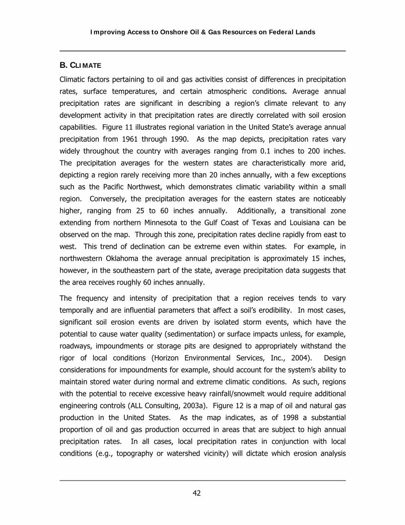
Improving Access to Onshore Oil & Gas Resources on Federal Lands
42
B. CLIMATE
Climatic factors pertaining to oil and gas activities consist of differences in precipitation
rates, surface temperatures, and certain atmospheric conditions. Average annual
precipitation rates are significant in describing a region’s climate relevant to any
development activity in that precipitation rates are directly correlated with soil erosion
capabilities. Figure 11 illustrates regional variation in the United State’s average annual
precipitation from 1961 through 1990. As the map depicts, precipitation rates vary
widely throughout the country with averages ranging from 0.1 inches to 200 inches.
The precipitation averages for the western states are characteristically more arid,
depicting a region rarely receiving more than 20 inches annually, with a few exceptions
such as the Pacific Northwest, which demonstrates climatic variability within a small
region. Conversely, the precipitation averages for the eastern states are noticeably
higher, ranging from 25 to 60 inches annually. Additionally, a transitional zone
extending from northern Minnesota to the Gulf Coast of Texas and Louisiana can be
observed on the map. Through this zone, precipitation rates decline rapidly from east to
west. This trend of declination can be extreme even within states. For example, in
northwestern Oklahoma the average annual precipitation is approximately 15 inches,
however, in the southeastern part of the state, average precipitation data suggests that
the area receives roughly 60 inches annually.
The frequency and intensity of precipitation that a region receives tends to vary
temporally and are influential parameters that affect a soil’s erodibility. In most cases,
significant soil erosion events are driven by isolated storm events, which have the
potential to cause water quality (sedimentation) or surface impacts unless, for example,
roadways, impoundments or storage pits are designed to appropriately withstand the
rigor of local conditions (Horizon Environmental Services, Inc., 2004). Design
considerations for impoundments for example, should account for the system’s ability to
maintain stored water during normal and extreme climatic conditions. As such, regions
with the potential to receive excessive heavy rainfall/snowmelt would require additional
engineering controls (ALL Consulting, 2003a). Figure 12 is a map of oil and natural gas
production in the United States. As the map indicates, as of 1998 a substantial
proportion of oil and gas production occurred in areas that are subject to high annual
precipitation rates. In all cases, local precipitation rates in conjunction with local
conditions (e.g., topography or watershed vicinity) will dictate which erosion analysis

Improving Access to Onshore Oil & Gas Resources on Federal Lands
43
methods are best suited to accurately reflect potential erosion impacts (Horizon
Environmental Services, Inc., 2004).
When surface development includes construction of oil and gas facilities consisting of
certain hydrologic components such as impoundments or water storage reservoirs,
surface temperatures can potentially result in varying surface or subsurface impacts.
High surface temperatures are associated with greater rates of evaporation and in
impoundments, for example, can result in an observed salinity increase within the
impounded fluids. From this, questions arise. How will the increased salinity levels
affect the surface soils? Will the reclamation process be prolonged or successful? Will
the fluid migrate or leach to groundwater and if so, what impacts to the subsurface will
result? Obviously, northern states such as Alaska or Pennsylvania will not experience
the same temperature levels that are observed during the summer months in New
Mexico or Alabama. In this situation, reduced evaporation rates in colder environments
can often limit the size of impoundments, assuming evaporation is critical to the overall
function of the facility (ALL Consulting, 2003a). Therefore, as stated earlier, local site
conditions will need to be accounted for during the impact assessment.
Another important regional climatic consideration is the relationship between air quality
and atmospheric or physical conditions. The air quality of any region is controlled
primarily by the magnitude and distribution of pollutant emissions and the regional
climate. The transport of pollutants from specific source areas is often times augmented
by local topography and meteorology. For example, the relatively level topography in
many Midwest states allows for uninhibited circulation of air pollutants. In general
terms, regions that receive increased wind speeds can potentially experience higher air
pollutant dispersal rates; whereas in areas of lesser wind speeds, pollutant dispersal is
likely to be less.

Improving Access to Onshore Oil & Gas Resources on Federal Lands
44
Figure 11 Average Annual Precipitation Across the United States

Improving Access to Onshore Oil & Gas Resources on Federal Lands
45
Figure 12 Hydrocarbon Production by Region and Resource in the United States.

Improving Access to Onshore Oil & Gas Resources on Federal Lands
46
Other, less technical air quality factors that may allow for delay in the NEPA or
development process relate to the populous of the local environment (and the perceived
perspective of air quality issues for that area) and the regional density of oil and gas
development already present. Populations located in rural areas are accustomed to only
minor air quality impacts that are typically associated with surrounding industrial
facilities, while populations in more urban settings have reached a certain level of
acclimation for higher air pollutant discharges. As such, observed air quality impacts,
however minor they may be, are perceived differently by local populations, which in turn
dictate or alter how fugitive air quality emissions are analyzed.
As oil and gas development or other industrial facilities increase within a region, state
allowable margins for air pollutant attainment levels will continue to decrease. In
Montana, the coal mining industry has observed a recent increase in development and
with this, an air pollutant discharge proportional in magnitude. As such, air quality
margins for the State are decreasing, or in other words, certain fugitive pollutants
continue to edge closer to State permissible maximum levels. Therefore, the overall
effects of increased development and associated pollutant discharges within the State of
Montana may limit subsequent oil and gas development or other types of development
activities in the future, unless reasonable, and possibly oil and gas specific legislation is
promulgated.
Seasonal Variability
An integral component of climatic variation that exists within many regions of the United
States is the observed seasonal differences in precipitation. For example, an important
characteristic of surface water systems in many basins is the water quality and quantity
variation shown by a single system over the seasons of the average year. In western
States for instance, such water systems will typically be supplied by ground water as
well as abundant runoff from precipitation during part of the year but, be limited to only
ground water flow during the rest of the year (ALL Consulting, 2003a). More
specifically, some seasonal rivers are fed by heavy fall monsoon rains while other
streams are fed by snow-melt in the spring; in either case, seasonal streams will show
wide variation in flow rate that is approximately repeated each year. Seasonal streams
also commonly carry water that varies seasonally – when the river is full of meteoric
water the quality is often high but when the river is being fed by ground water the
quality may be demonstrably lower. Seasonal variation can be documented by frequent

Improving Access to Onshore Oil & Gas Resources on Federal Lands
47
flow rate and water quality measurements, often combined into monthly averages over
several years to level out statistical variations. Historical monthly averages for flow rate
and water quality parameters (important cations, total dissolved solids, sodium
adsorption ratio, etc) will demonstrate seasonality for particular streams (ALL
Consulting, 2003a). When characterizing such seasonal streams, federal land managers
will describe water-quality parameters in terms of seasonal flow not as an annual
average number.
Global Climate Change
An increasingly important aspect of the environment is the climate changes that
accompany increases in the average CO2 content of the Earth’s atmosphere. This global
process can be expressed locally by a variety of means, from general temperature shift
to changes in the amount and timing of precipitation. These local changes can be
profoundly important to residents and to local biota. Federal land managers will be
driven to include this variability when characterizing the environmental resources. Local
climate aspects would be more accurately described in terms of contemporary trends in
addition to historical averages. The average of the past ten years records may be more
indicative than the average of the past 120 years. In addition, plant and animal
populations may no longer be in equilibrium with the local climate and because of this,
the biota may be particularly vulnerable to land development issues.
Perhaps one of the most fitting illustrations of current challenges associated with
managing resources in a time of such climatic variability, is that of the Colorado River
Basin’s continual and increasing threat of drought. The National Research Council (NRC)
has issued a report entitled Colorado River Basin Water Management: Evaluating and Adjusting to Hydroclimatic Variabilty in which NRC explores future challenges of
managing water resources in the basin.
Temperature records for the past century and climatic modeling projections in this
region of the United States indicate a warming trend. Higher temperatures can have a
profound affect on the hydrological landscape in this region due to decreased quantities
of precipitation being stored as snow, spring snow melt peaking early, and increased
losses of water via evapo-transpiration. According to NRC, based on analysis of many
climate model simulations, increased annual temperatures will reduce future
precipitation and stream flows in the Colorado River Basin.

Improving Access to Onshore Oil & Gas Resources on Federal Lands
48
In addition to significant climate warming patterns in the western region of the U.S.,
NRC has identified a rapid increase in urban populations in this region as a second
culpable trend that will further stress future availability of water. From 1999-2000
Arizona’s statewide population is estimated to have increased by approximately 40%
(NRC, 2007). During this time period, Colorado’s statewide population also saw a
significant increase of approximately 30% (NRC, 2007). Projections suggest that this
trend will continue. Despite currently implemented water conservation programs, it is
believed that population growth will continue to drive increases in water demand (NRC,
2007). In order to meet future costly and un-avoidable shortages, tradeoff mechanisms
will likely be necessary. For example, at the present time agricultural uses account for
roughly 80% of western water supplies. A greater percentage of this supply may need
to be reallocated to the municipal sector in the future. Such a transfer could result in
possible third party effects such as adjustments in costs for rural communities and
varying stresses to ecosystems.
Additionally, new data has surfaced concerning stream flows being lower than what has
been recorded at any time in the past 100 years. For many years, scientific
understanding of the Colorado River’s flow regime has been primarily based on data
obtained from gauging stations along the river, some of which were first installed in the
late 1800’s. However, as knowledge about the hydrology of the Colorado River system
has matured, data from gauging stations is increasingly augmented with information
collected in studies that focused on indirect evidence of historic climates. One such
study focused on reading tree-ring data in order to learn more about the historic
hydrology of the basin. Broad tree-rings are indicative of periods of high precipitation
and flow rates while narrower tree-rings indicate dry periods that were stressful to the
tree. Hydrological reconstructions based on tree-ring readings suggest that Colorado
River flows have historically shifted into approximately ten-year periods in which
average flows were significantly lower or higher than the moving-average annual rates.
This finding supports the supposition that perhaps the future hydrology of the Colorado
River basin may not be appropriately characterized by historical gauged records alone.
Successfully meeting the likely water demands with the likely reductions in available
water supplies will entail strong and prolonged cooperation among the many involved
parties. All seven of the states in which the basin is located have entered are
collaborating on draft a set of guidelines on the subject of drought preparedness. The
gap between water supply and demand may need to be addressed by alternative

Improving Access to Onshore Oil & Gas Resources on Federal Lands
49
supplies such as produced water from oil and gas fields. These water supplies may be
appropriate for some agricultural uses while other water supplies may be economically
treated to use requirements. This document may play a role in educating petroleum
producers and community water planners about the availability and quality of produced
water.
C. BIOLOGICAL FEATURES
The ecology of the United States is composed of multifaceted community biota and
habitat structure that is capable of supporting complex vegetative composition and
wildlife diversification. Variation of this assessment component is not only observed
from region to region, but within regions themselves and even within small, local
ecosystems composed of varying degrees of vegetative and wildlife trophic levels. In
general, effective assessment of oil and gas related impacts to biological features will
typically depend on the specific types of biological features present in the area, as well
the perceived importance of these features from a public or regulatory perspective. For
example the wood frog in Alaska is considered a rare species that is afforded significant
protection from oil and gas related activities and subsequently, has the potential to limit
certain aspects of development. Conversely, this frog has a broad distribution in the
continental United States, which allows for reasonable amounts of oil and gas related
impacts without further consideration of impacts.
To further illustrate this point, sage-grouse in Montana or Wyoming have the potential
to delay oil and gas development without proper planning because of the public’s high
degree of interest in protecting them, despite the fact that both states allow hunting
sage grouse. The intense public interest drives regulatory scrutiny as well as protection
by federal land managers. To satisfy regulatory mandates, sage-grouse must be
inventoried within the development area on three separate occasions during the bird’s
known breeding season. Although this requirement does not necessarily translate into
delays in development, it does demonstrate the importance of certain factors that may
only pertain to certain regions or localities that, without proper planning, potentially slow
or limit access to federal lands.
Although cumulative impacts to biological populations or their habitats are often difficult
to consistently quantify or accurately reflect due to the complex dynamics which define
regional environments. An essential, yet variable component that often requires
integration into the methods analysis approach for biological features is surface

Improving Access to Onshore Oil & Gas Resources on Federal Lands
50
reclamation. The successful reclamation of any given habitat can be viewed as a
management tool which can potentially reduce future impacts to biological resources.
From this it can be inferred that restoring habitat features to pre-existing conditions
would result in little to no future impacts. However, certain biological features are more
difficult to restore than others and biologic species often respond to surface disturbance
in different ways. For instance, less vegetative structure in arid environments like those
observed in the oil and gas fields of New Mexico are, from a functional perspective,
often easier to reclaim than wetland habitats found on oil and gas lands in Louisiana.
Additionally, the bald eagle, for example, is an isolated species that is sensitive to
surrounding disturbance activities. Residential eagles that migrate to adjacent lands
during oil and gas development for a prolonged period may not return to the area even
after the lands have been reclaimed to original conditions. This is why many BLM field
offices, for instance, will not approve oil and gas related surface disturbances that are
within one mile of eagle nest or roost site locations.
Lastly, from a surface impact perspective, vegetative cover is commonly used to
estimate impacts that will arise from oil and gas related activities because it is a physical
representation of the ecosystem that is quantifiable. Typically, species composition and
percent cover are two parameters that are used when describing a region’s vegetative
structure and are usually limited to defining ground cover and herbaceous vegetation
since the degree of soil erosion is more dependent on their presence or absence. For
instance, herbaceous/grassy communities are generally more capable of decreasing
erosion because they contain more dense rooting systems; whereas upland woody
species are generally more proficient at nutrient uptake. Thus, it is reasonable to
assume oil and gas related surface impacts would be more pronounced in forest habitats
versus prairie grass habitats and that differing approaches would be required to
accurately reflect surface impacts.
D. HYDROLOGY
Regional variations in groundwater and surface water quality and aquatic-ecosystem
health are controlled by a combination of factors including chemical use, land use, land-
management practices, and natural features including geology, hydrology, soils, and
climate (USGS, 2004). In multiple water quality assessments performed by the USGS
(2004), data indicates water quality conditions are similar over large regions that have
similar natural features and land management practices. For example, throughout much

Improving Access to Onshore Oil & Gas Resources on Federal Lands
51
of the Upper Midwest, groundwater underlying intensive agriculture lands, in general,
have lower than expected concentrations of agricultural chemicals because the water is
protected by low-permeability soils and glacial till. Surface water quality is more
susceptible to agriculture or urban sources of non-point source pollution because
protective barriers or natural filters seldom exist. In other regions where soils are highly
permeable, underlain by sand and gravel or karst, groundwater is more susceptible to
contamination from surface use of chemicals and land management activities (USGS,
2004).
Climatic variations also play an important role in hydrologic resources. Figure 11 shows
the variation in precipitation across the United States, which can be used as an inverse
correlation to the perceived value of hydrologic resources. In areas where precipitation
is low (< 30 in/yr), groundwater and surface water resources are scarcer and water
quality and quantity receive more attention from the public and regulators. As a result
activities which influence the quality or quantity of these resources are more closely
monitored as anthropogenic influences can have more direct affects resulting in changes
to these resources. Climate change needs to be considered in those areas with little
surface water and where precipitation is meager; rainfall average over the past 100
years may be adequate but if the conditions of the past ten years were to become the
norm, how would this affect local surface water resources?
To accurately reflect impacts to surface or groundwater, it is important to not only
consider potential chemical or sedimentation discharges (e.g., SAR, TPH, Barium, TDS),
but to also consider the relationship between public water needs or perceptions, pre-
existing water quality conditions, and the volume of available water. The Powder River
Basin for example, contains water systems such as the Tongue, Little Powder and
Powder Rivers that are composed of relatively high to low quality waters. The quantity
of water that flows through these systems is low in comparison to surface water bodies
with similar sized watersheds in the Midwest and Eastern United States. This results in
magnified impacts when lower quality waters such as oil and gas produced water is
discharged to rivers. Mississippi Basin watersheds, as well as east coast watersheds, on
the other hand are typically characterized by large water sources with low quality water,
which allows for greater discharge because the quality of the water is less likely to be
impacted.

Improving Access to Onshore Oil & Gas Resources on Federal Lands
52
As previously noted, chemical use, land use, land-management practices, and natural
features including geology, hydrology, soils, and climate, control the variability in surface
water quality that is present across the United States (USGS, 2004). An example of the
influence of all these factors can be seen by comparing two watersheds of
approximately similar size. The Powder River near Moorhead, Montana, and the Brazos
River near Aspermont, Texas, have similar size drainage areas of approximately 8,800
square miles. Figure 13 plots a comparison of the average water quality as represented
by salinity concentrations versus the average monthly discharge rates for the two rivers.
The plots show the relative difference in water quality that can occur in two river
systems of the same size from the various influences on surface water quality. The
Powder River in Montana has relatively low average sodium concentrations (<250 mg/l)
that do not vary considerably when flow in the river increases or decreases (Figure 13).
In contrast, the Brazos River quality appears to have a correlation between the relatively
salinity and rate of discharge with lower discharges having higher salinity
concentrations.
E. SURROUNDING HUMAN ACTIVITIES
When considering regional or local site conditions that might be impacted by increased
access to federal lands, it is important to consider the surrounding human activities and
land use in the area. For instance, in 2005 the U.S. Department of Agriculture (USDA)
estimated the average farm size in the United States to be approximated 443 acres
(NASS, 2005). Likely impacts from a small operational site, when compared to a typical
farm, is not likely to cause a measurable increase in erosion and/or sedimentation
relative to the existing rates resulting from routine agricultural activities. Additionally,
considering that oil and gas development consists of more stringent water runoff
regulations, small oil and gas sites are typically required to design and monitor surface
runoff, thereby further reducing potential erosion issues. Further, when oil and gas sites
are located in an agricultural area, operators are generally sensitive to the surrounding
land use and attempt to limit stormwater runoff from construction sites to avoid
negatively impacting the agricultural activities.

Improving Access to Onshore Oil & Gas Resources on Federal Lands
53
Figure 13 Salinity Comparison for Two Watersheds Montana vs. Texas.
Another surrounding land use consideration relates to the expansion of exploratory
operations in atypical or non-traditional environments, such as urban or residential
settings. Modern technologies are facilitating this trend as they allow for safe and
efficient production, as well as minimization of obtrusive affects to natural landscape
characteristics. As can be expected though, higher density residential development can
lead to certain conflicts that may not be experienced in more rural environments. For
instance, federal and state regulations which govern oil & gas operations can limit or
hinder oil & gas development under certain conditions to assure important resources
(e.g., water, visual, wildlife, etc.) are afforded certain protection. In an urban setting,
local municipalities may hinder the development process further by promulgating more
stringent regulations specific to their situation.
For example, upland hardwood forest is a common forest habitat type found throughout
much of the United States that in most cases is not considered a sensitive habitat and
thus, not afforded special protection. However, in urban areas that have experienced
moderate levels of land clearing activities to accommodate population demands and

Improving Access to Onshore Oil & Gas Resources on Federal Lands
54
subsequent residential needs, the upland hardwood forest may be considered a sensitive
habitat, both from a functional and visual perspective. In such cases, development of
the area may become overtly complex in order to satisfy local ordinances and expensive,
typically in the form of mitigation fees. Other prominent issues in urban settings may
include; safety, due to increased human presence and activity; limitations and/or options
for produced water management; land availability; and public acceptance or “not in my
backyard” mentality.
Increasingly, rural populations are changing and the changes are resulting in a different
public perspective of development. Oil and gas wells in the western United States are
often located in rural areas near farms or ranchland; however, it is becoming
increasingly more common for areas that were once rural to develop into small
communities as the population of the United States moves out of the cities. This trend
of moving away from metropolitan areas can be seen in data from the Economic
Research Service and United States Department of Agricultural for the 1990’s which
shows some non-metropolitan areas of the Rocky Mountain states to have increases in
population of over 25 percent while rural areas in the Midwest have seen populations
decrease (ERS/USDA, 2004).
In any case, rural settings can also present the oil & gas industry with unique
challenges, but typically will differ from those encountered in a more urban
environment. As with the above example urban setting, the use of heavy equipment for
road construction or well drilling constitutes a potential risk by changing the natural
landscape. In this situation however, construction may affect recreational uses such as
hiking, fishing, hunting, etc., as well as infringe on the solitude and rural characteristics
of the area. In addition, other activities such as increased travel and vandalism resulting
from access improvements, wildlife displacement and increased noise in the area may
affect the area.
Environmental justice may also require consideration in certain situations, especially in
more rural settings. Executive Order 12898, “Federal Actions to Address Environmental
Justice in Minority and Low-Income Populations” (1994) requires the non-discriminatory
treatment of minority populations and low-income populations for projects that occur on
federal lands, require federal permits, use federal funds, or are otherwise under the
jurisdiction of a federal agency. Typically, in the NEPA process disproportionately high
or adverse health or environmental effects on such populations must be identified and
addressed as appropriate.

Improving Access to Onshore Oil & Gas Resources on Federal Lands
55
In general, additional employment opportunities generated by the oil & gas industry
within areas prominently characterized by minority and/or low-income populations can
provide some financial stability for many families, as long as employment is conducted in
an appropriate manner. However, one facet of this law that can be commonly
overlooked, especially in arid regions, is water drawdown. In Montana’s Powder River
Basin for example, CBNG development has the potential to result in the depletion of an
estimated 21 percent of the groundwater resources. Furthermore, the drawdown also
has the potential to reduce surface water flows in some drainages depending on specific
site conditions. Obviously, the availability of water is important, as many rural families
depend on the supply of groundwater for their household and ranch/agricultural
(irrigation) applications. Subsequently, from a regional perspective water availability is
an important environmental variation to identify and assess during the NEPA process.

Improving Access to Onshore Oil & Gas Resources on Federal Lands
56
THIS PAGE INTENTIONALLY LEFT BLANK

Improving Access to Onshore Oil & Gas Resources on Federal Lands
57
IV. MANAGEMENT CONSIDERATIONS BY AGENCY
Development of oil and gas reserves on federal lands within the United States takes
place in a variety of regulatory settings and land use environments that often require
authorizing agencies to prioritize potential resource impacts differently. Additionally,
federal agencies, in general, are legally mandated to develop multiuse land management
plans to satisfy the regulatory requirements per the land’s use, as well as assure
compliance with internal directives that often define an agency’s “purpose”. As
discussed in Chapter 3 of this document, regional environmental variation on federal
lands can result in the formulation of inconsistent analysis methods that are used to
define local resource impacts. Oil and gas development on federal lands is further
complicated because of the broad and diverse range of land uses that are management
by various federal agencies. These uses can include, but are not limited to, recreation,
academic study, livestock grazing, agriculture, plant harvesting, commercial timber
cutting, protected wildlife refuges, hunting and outfitting, traditional cultural properties,
saleable and leasable mineral development, and aesthetic appreciation. To further
illustrate these issues, the Swanson River case study (Appendix A) provides a practical
discussion to demonstrate oil and gas specific land management variation that can exist
between federal agencies. The case study also helps to illustrate the regulatory
relationships that exist between federal and state programs with discussion relative to
the associated conflicts or access delays that may arise.
A frequent grieve in NEPA proceedings involves agency “segmentation”. For instance,
when considering the Endangered Species Act, agencies often must decide on a
preferred alternative before receiving a biological opinion from the U.S. Fish and Wildlife
Service. Additionally, because federal agencies involved in oil and gas development will
differ in their missions, jurisdictions, and their management approach, significant
disparities can occur when one agency or a component of an agency focuses on taking a
specific action that is at odds with those starting to prepare a NEPA analysis. To
illustrate this point, jurisdictional conflict occurred in South Shale Ridge near Grand
Junction, Colorado when the BLM’s Grand Junction Field Office disregarded comments
submitted by the U.S. Fish and Wildlife Service (USFWS) in moving to lease the South
Shale Ridge area for oil and gas drilling. In formal correspondence by the USFWS, the
Service questioned BLM’s decision to open proposed wilderness lands in the
development area due to the project’s likelihood to impact sensitive species known to
inhabit the area (Lindauer, 2005). Although in this situation the USFWS could not

Improving Access to Onshore Oil & Gas Resources on Federal Lands
58
legally force BLM to move the project location, the conflicting management objectives
between the two agencies resulted in the involvement of public interest groups and
subsequently delayed the project.
To reduce inter-agency conflicts, the National Environmental Policy Act specifically
directs federal, state, and local governments to cooperate and integrate regulatory
objectives and missions with the goal of achieving productive initiatives to satisfy public
and national needs. As an example, the EPA, Region 8 finalized a supplement to NEPA in
1998, through a Federal Leadership Forum, to provide cooperating agency guidelines for
oil and gas development on public lands. More specifically, these guidelines established
the role and responsibilities of the BLM, National Park Service, USFWS, Forest Service,
and the EPA, “to the extent practicable, permitted by law, and not clearly inconsistent
with essential agency functions, when preparing environmental documents associated
with oil and gas activities within the states of Utah, Colorado, Montana, Wyoming, and
North and South Dakota” (Federal Leadership Forum, undated). In addition, in recent
years this premise has been further supported by President Bush’s Executive Order on
Facilitation of Cooperative Conservation.
A present day example of cooperative interaction between two authorities took place on
the Jonah Infill Drilling Project EIS in 2005. In this example, the Governor of Wyoming,
Mr. David Freudenthal, worked directly with BLM’s Pinedale Field Office to thwart
potential litigation and project delays by commenting and suggesting appropriate actions
for resource impact analysis. In this case, the people of Wyoming were represented via
communication to BLM through the Governor’s office which helped BLM streamline their
decision process. Additionally, this exchange of information between these two public
entities helped reduce public controversy and agency entanglements, as well as
facilitated the formulation of an adaptive management approach to accurately and
appropriately assess resource impacts important to the local communities.
According to data obtained form the Council on Environmental Quality NEPAnet (2005),
from March 1, 2002 to February 28, 2004, 31,792 Environmental Assessments (EA) and
669 Environmental Impact Statements (EIS) were performed by Federal Departments or
Agencies in the United States. Of these, 2,438 EA’s or approximately 8 percent were
executed with cooperating agencies while, 284 or approximately 43 percent of the EIS’s
were performed with cooperating agencies. The importance of interagency cooperation
or the concept of an interdisciplinary approach to expedite oil and gas development on

Improving Access to Onshore Oil & Gas Resources on Federal Lands
59
federal lands cannot be overemphasized because of the predicted energy shortcoming
that will most certainly arise without the development of additional national mineral
reserves. Additionally, intra-agency collaboration to streamline access to public lands
requires additional attention because of the significant role the oil and gas industry has
on the overall economy of the United States. To financially illustrate the importance of
this idea, energy resources on public lands within the United States generated $1.2
billion in revenue (BLM, 2006a). Of this, energy, mineral royalties, and other related
factors accounted for $1.1 billion of the total (BLM, 2006a). Furthermore, the direct and
indirect economic impact of energy and mineral production on the public lands
amounted to an estimated $24.7 billion (BLM, 2006a).
The intent of this section is to provide a general overview of the key federal agencies
involved in the oil and gas industry and their regulator relationship with one another, as
well as discuss their primary regulatory roles that may affect federal land access during
the development process.
A. DISTRIBUTION OF FEDERAL LAND MANAGEMENT
The federal government owns mineral resources contained within approximately 700
million acres of subsurface land (GAO, 2004) of which, approximately 570 million acres
are open for oil and gas leasing (Environmental Working Group, 2006). Since 1982, the
federal government has leased or offered for oil and gas drilling 229 million acres of
public and private land through the sale of leases which typically last for 10 years or
more.
The BLM is responsible for the subsurface management of all these lands; whereas they
only have administrative rights for 37 percent of the corresponding surface area
(approximately 261 million acres) (GAO, 2004). The United States Forest Service (USFS)
manages 27 percent of the surface area, or approximately 192 million acres, while the
National Park Service, USFWS, the Bureau of Reclamation and the US Army Corps of
Engineers collectively manage 27 percent of surface area, or 190 million acres (GAO,
2004). Table 2 summarizes, in millions of acres, the quantity of the lands managed per
responsible federal agency in the United States. It is important to note that four million
acres of the subsurface located under federally owned surface lands is privately held and
that some acquired forest lands have retained their mineral rights.
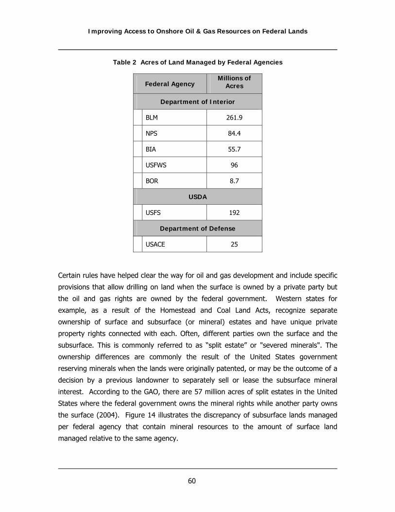
Improving Access to Onshore Oil & Gas Resources on Federal Lands
60
Table 2 Acres of Land Managed by Federal Agencies
Federal Agency Millions of
Acres
Department of Interior
BLM 261.9
NPS 84.4
BIA 55.7
USFWS 96
BOR 8.7
USDA
USFS 192
Department of Defense
USACE 25
Certain rules have helped clear the way for oil and gas development and include specific
provisions that allow drilling on land when the surface is owned by a private party but
the oil and gas rights are owned by the federal government. Western states for
example, as a result of the Homestead and Coal Land Acts, recognize separate
ownership of surface and subsurface (or mineral) estates and have unique private
property rights connected with each. Often, different parties own the surface and the
subsurface. This is commonly referred to as “split estate” or "severed minerals". The
ownership differences are commonly the result of the United States government
reserving minerals when the lands were originally patented, or may be the outcome of a
decision by a previous landowner to separately sell or lease the subsurface mineral
interest. According to the GAO, there are 57 million acres of split estates in the United
States where the federal government owns the mineral rights while another party owns
the surface (2004). Figure 14 illustrates the discrepancy of subsurface lands managed
per federal agency that contain mineral resources to the amount of surface land
managed relative to the same agency.

Improving Access to Onshore Oil & Gas Resources on Federal Lands
61
B. OIL & GAS MANAGEMENT ON FEDERAL LANDS
Although there are many federal agencies that are associated with the development of
oil and gas, BLM is the principle agency responsible for the management of subsurface
mineral extraction in the United States. However, in many situations surface
management over BLM administered minerals is overseen by other federal agencies. In
any case, the lead federal agency responsible for managing the surface, whether it is
the BLM or another agency, is known as the Surface Managing Agency (SMA). In
general, the SMA is under legal mandate to provide varying, but reasonable land use
specific protection of surface resources that in some circumstances conflict with oil and
gas development. Under these circumstances, successful oil and gas development on
federal lands necessitates collaborative decision making between BLM and the SMA to
effectively balance SMA management directives with fluid mineral development.
Although in theory this can be an effective approach or resolution, because of varying
agency missions, jurisdictions, and concerns, development of federal lands can often be
delayed or impeded. Further discussion of this issue is detailed in the following
subsections.
Figure 14 Management Distribution of Subsurface and Surface Mineral Resources
(Source: GAO, 2004)

Improving Access to Onshore Oil & Gas Resources on Federal Lands
62
C. FEDERAL AGENCIES INVOLVED IN OIL & GAS DEVELOPMENT
The following agency discussion is aimed at describing the principle regulatory directives
of the BLM, the USFWS and the USFS since their policies and responsibilities, in various
capacities, can affect fluid mineral development. This section will also provide a general
overview of other federal agencies that are often involved in the oil and gas
development process.
Bureau of Land Management
The Secretary of the Interior, through the BLM, issues oil and gas leases on federal
lands under various authorities. In addition to leasing federally owned oil and gas
minerals, BLM is also responsible for supervising the exploration, development, and
production operations of these resources on both Federal and Indian lands. BLM
administers public lands within a framework of numerous laws, the most comprehensive
being the Federal Land Policy and Management Act of 1976 (FLPMA). All Bureau
policies, procedures, and management actions must be consistent with FLPMA and the
other laws that govern public land use. BLM responsibilities are generally the same on
split-estate (private surface, federal mineral) since, under these conditions the impacts
that occur on private surfaces are caused as a direct consequence of BLM approved
federal lease activities. A majority of the lands managed by BLM are located in the
western United States, including Alaska, and contain a wide variety of resources and
uses such as energy and minerals; timber; fish and wildlife habitat; and wilderness
areas. Figure 15 shows the distribution of BLM field offices and the respective
boundaries for the field offices. This map reflects the disproportional density of BLM
administered public lands within the western United States. (Note: the figure does not
delineate the additional 300 million acres of BLM subsurface mineral estates that are
located throughout the United States.)
An important aspect of BLM land management is the directive, as mandated by the
FLPMA, to develop Resource Management Plans (RMP). An RMP is best described as a
land use plan that defines broad, multiple-use guidance for managing public lands and
typically includes a mineral resource component, which provides land use policy and an
estimate of reasonable foreseeable oil and gas development. The future development is
usually estimated as a number of new oil, gas and possibly coal bed natural gas (CBNG)
wells anticipated over the next 10 or 20 years. Currently, more than 140 RMPs are
providing direction and authorization for land uses on public lands (BLM, 2006a). RMPs

Improving Access to Onshore Oil & Gas Resources on Federal Lands
63
are a key consideration during the planning process for development of BLM
administered oil and gas since mineral extraction is often contingent upon RMP approval
and implementation. In Alaska, for example, BLM is currently not administering new oil
and gas leases in the Swanson River Field or surrounding areas and are not expected to
do so until a revised RMP of the area is completed.
The defined role and expectations that BLM has for oil and gas development on federal
lands is largely dependent on the development of regional or local RMPs and associated
NEPA documents. RMPs provide BLM with an administrative tool to afford protection for
certain resources or land uses and include: Wilderness Study Area (WSA), Areas of
Critical Environmental Concern (ACEC), Outstanding Natural Areas (ONA), Research
Natural Area (RNA), Special Recreation Management Areas (SRMA), and Extensive
Recreation Management Areas (ERMA). Although BLM policies typically provide a
consistent approach to oil and gas development per RMPs in the United States, regional
variation in cooperating SMA responsibilities, state mandated directives, or oil and gas
policy disparities can affect BLM’s role or complicate development. Several examples to
demonstrate these points are discussed below.
In general, interaction between cooperating federal agencies can be viewed in a positive
manner. For instance, development of a comprehensive resource handbook entitled
Surface Operating Standards for Oil and Gas Exploration and Development, or “Gold
Book”, was prepared by BLM and the USFS. This guide represents a good example of
interagency cooperation that provides standards for oil and gas geophysical operations,
construction, operation, production, reclamation, and abandonment, as well as
procedural guidelines for development of federal fluid minerals. However, in Alaska for
example, policy missions between BLM and the USFWS often conflict, which can result in
the delay of existing and future development.
The relationship that exist between Alaskan BLM and USFWS offices differs, to a certain
extent, from that which is experienced in the continental United States, e.g., Montana,
Wyoming, New Mexico, etc. More specifically, because of state specific legislation
[Alaska National Interest Lands Conservation Act (ANILCA)], the USFWS in Alaska has
been granted, from a comparative perspective, additional authorization over oil and gas
related activities on public lands. For instance, in the Swanson River oil and gas field,
which is located within the Kenai Wildlife Refuge, the USFWS regulates surface uses to
such an extent that BLM supported oil and gas development is contingent upon approval

Improving Access to Onshore Oil & Gas Resources on Federal Lands
64
from the USFWS based on priorities and “compatibility determinations”. These
compatibility determinations essentially authorize the USFWS to manage and restrict
land uses within the Refuge. As an outcome of these determinations, oil and gas
development, with the exception of pre-existing leases, has been deemed incompatible
with the purpose of the Refuge and is therefore not permitted. A more detailed
discussion of this subject matter is presented in the Swanson River case study (Appendix
A) and a discussion of the USFWS role in the continental United States is discussed in a
following Section.
Lastly, as an outcome of the recent Montana and Wyoming Coal Bed Methane (CBM)
EISs and the subsequent Records of Decision, the Montana and Wyoming State BLM
offices require operators to submit a Plan of Development (POD) prior to initiation of
CBM (now referred to as Coal Bed Natural Gas (CBNG)) development on federal lands.
For any given area or number of wells, PODs must define certain management
parameters to assure CBNG development occurs in an environmentally sound manner
and can include, for instance, water management, surface use, surface reclamation, and
wildlife monitoring plans. The point of regional interest here is two-fold: (1),
development of BLM PODs is only required in Montana and Wyoming; and (2) traditional
oil and gas development on federal lands are not subject to this requirement. Although
the latter may change pending new BLM directives, this situation illustrates policy
differences that can exist within an agency which can affect oil and gas development on
a regional basis.

Improving Access to Onshore Oil & Gas Resources on Federal Lands
65
Figure 15 Bureau of Land Management Field Offices and Office Boundaries

Improving Access to Onshore Oil & Gas Resources on Federal Lands
66
Fish & Wildlife Service
The USFWS is responsible for protecting and conserving migratory birds, endangered
species, certain marine mammals, inland sport fisheries, and specific fishery and wildlife
research functions. Currently, the agency manages approximately 96 million acres and
consists of all lands contained within the National Wildlife Refuges System (NWRS). In
1920, the Mineral Leasing Act authorized the Secretary of the Interior to issue leases for
oil and gas development on public domain lands including lands reserved for wildlife
refuges. However, in 1966, as well as regulations pursuant to the National Wildlife
Refuge System Improvement Act of 1997, the National Wildlife Refuges System Act
emplaced “compatibility” standards for employment by the USFWS to ascertain the
legitimacy of proposed land uses and subsequent authorization to limit or restrict uses
deemed contrary with the purposes for which individual refuges (units) were established
(USFWS, 2005a).
In principle, these “compatibility” standards (or compatibility determinations) enacted by
the National Wildlife Refuges System Act are the fundamental USFWS regulatory process
for any National Wildlife Refuge (NWR) in the United States. The determination of
compatibility is fulfilled through the development of refuge specific Comprehensive
Conservation Plans (CCP), which are congressionally mandated plans for providing broad
policy guidance and establishment of long-term goals and management objectives on
refuges (Frates, 1999). Currently, federally-owned oil and gas rights on NWR lands,
including the Arctic National Wildlife Range, are not available for leasing as oil and gas
activities are deemed incompatible with the purpose of NWRs. However, in a decision
by the Interior Board of Land Appeals in 1981, it was determined that the prohibition
against oil and gas leasing on "refuge lands" did not include lands acquired from other
sources. In this situation, the persons holding those privileges have the full right to
develop their minerals as long as reasonable regard for the surface estate, as required
by state law, is met. Because of this decision, the USFWS does not have authority over
non-federally owned minerals located on NWR lands in the continental United States,
with several exceptions, nor do they have the authority to conduct oil and gas related
compatibility determinations over non-federally owned minerals, again with several
exceptions including Alaska (Frates, 1999). A more detailed discussion of this topic can
be found in the Swanson River case study which is presented as Appendix A.

Improving Access to Onshore Oil & Gas Resources on Federal Lands
67
Of the 567 units present in the NWRS, 77 (or 14 percent) had oil or gas activities on
their land in the year 2000 (GAO, 2001). Figure 16 depicts NWRs that accommodate oil
and gas related activities. These units are located in 22 states and distributed through
all seven regions of the USFWS: Louisiana, with 19 units, and Texas, with 11 units, had
the most units with oil or gas activity. The majority of these units (41) which permit oil
and gas development occur in situations where private entities, states, or native
corporations, rather than the federal government, own the mineral rights. In 27 units, a
pipeline constitutes the only oil or gas activity within a refuge, and these pipelines either
were present before the USFWS acquired the land or were constructed under a right-of-
way permit issued by the Agency after the land was acquired (GAO, 2001). In only eight
circumstances does the federal government own the mineral rights and lease the refuge
for oil and gas development. These include:
• Bitter Lake National Wildlife Refuge, New Mexico
• Bowdoin Wetland Management District, Montana
• Delta National Wildlife Refuge, Louisiana
• Hewitt Lake National Wildlife Refuge, Montana
• J. Clark Salyer National Wildlife Refuge, North Dakota
• Medicine Lake National Wildlife Refuge, Montana
• Salt Plains National Wildlife Refuge, Oklahoma
• Upper Souris National Wildlife Refuge, North Dakota
Although oil and gas related activities have been deemed incompatible with the purpose
of NWRs, there are some varying exceptions that allow for oil and gas development to
take place on refuges in which the federal government owns the oil and gas mineral
rights. For instance, in two of the eight above listed units, oil or gas was already being
produced on the land when the USFWS acquired it for inclusion in the NWRs. In four
units, the federal government leased the refuge land for oil and gas development via a
“drainage lease” to protect its interest in oil or gas resources that were being “drained”
from refuge land by wells of another owner operating on adjacent land (GAO, 2001).

Improving Access to Onshore Oil & Gas Resources on Federal Lands
68
Figure 16 National Wildlife Refuges with Oil and Gas Wells

Improving Access to Onshore Oil & Gas Resources on Federal Lands
69
In this particular situation, once BLM determines that drainage is occurring on refuge land, it
requests the USFWS’s consent to lease the land to allow the federal government to collect a
compensatory royalty for the oil and gas loss from drainage (USFWS, 2005). Before agreeing to
lease the land, the USFWS must determine that the proposed activity is compatible with the
purpose for which the refuge was established and provide BLM with recommendations for lease
stipulations. When a drainage lease is issued, it generally contains a “no surface occupancy”
stipulation that prohibits the occupancy and use of refuge land for the extraction of resources.
As a result, operators who obtain such a lease must extract the oil and gas from land located
outside the boundaries of the refuge via directional drilling.
In one of the two remaining eight units that allow oil and gas development, the executive order
establishing the refuge in 1938 opened its land to oil and gas leasing because it was located on
a known producing gas field and, at the time, oil and gas development on refuge land was not
prohibited by Interior’s regulations (GAO, 2001). In the other refuge, leasing was allowed under
an exception to Interior’s 1947 regulations that prohibited oil and gas leasing on refuge land.
This exception, which no longer exists, allowed leasing if the lessees had an approved unit
agreement plan that stipulated how the oil and gas field would be developed and operated
(GAO, 2001).
Although the USFWS is not the principle agency responsible for oil and gas development on
federal lands, as demonstrated they do supervise some surface lands where mineral leasing
occurs. Of interest to this is currently the USFWS does not have a line item in its budget to
fund the management of oil and gas activities that occur in the NWRS (GAO, 2001). As a
result, units that have individuals assigned to the management of oil and gas activities usually
use funds from their unit budget or find alternative sources of funding for this function.
According to the USFWS only one refuge in the United States, the Sabine National Wildlife
Refuge in Louisiana, has a full-time person assigned to oil and gas activities (GAO, 2001). The
position is funded from a damage fund account which contains money collected from oil and
gas operators for site-specific damage to refuge land.
The United States Forest Service
The USFS is responsible for managing 192 million acres, including 155 national forests and 20
grasslands. Currently, in the United States there are 26 USFS districts (e.g., National Forests
and National Grasslands) that have oil and gas production wells located within their boundaries
(USFS, 2005a). As with all federal lands, oil and gas minerals located under USFS land are
managed by the BLM; however, it is the responsibility of USFS for determining which lands may

Improving Access to Onshore Oil & Gas Resources on Federal Lands
70
be leased, as well as establishment of surface stipulation requirements as authorized by the
USDA Forest Service Oil and Gas Resources Regulation (36 CFR, Subpart 228, Section E) and
the federal Onshore Oil and Gas Leasing Reform Act of 1987. Under this authority, permits to
drill on USFS management lands are not granted without the analysis and approval by the USFS
of a surface use plan, which covers proposed surface disturbing activities within the lease area
(USFS, 2005b).
Although the official position of the USFS is to encourage mineral development on lands they
manage, typically oil and gas related activities on these lands are limited because of restrictive
land use stipulations that exist for a variety of ecological, cultural, and socioeconomic reasons.
Under certain conditions, oil and gas development can occur on lands with restrictive lease
stipulations, but typically will require performance of either an Environmental Assessment (EA)
or EIS (USFS, 2005a). Conversely, on USFS lands that do not contain such stipulations, mineral
related permits may qualify for a Categorical Exclusion (CE) if the proposed activity is within a
specified threshold of environmental impact (USFS, 2005a).
Under the Energy Policy Conservation Act (EPCA), Congress directed the Department of the
Interior to complete a summary of BLM and USFS land management plan decisions for oil and
gas leasing for the most potentially important mineral areas with large amounts of public lands
(USFS, 2005a). Phase I of this study focused on leasing decisions for federal managed lands
for the Montana Thrust Belt, Powder River Basin, Greater Green River Basin, Uinta/Piceance
Basin, and Paradox/San Juan Basin. Leasing decisions were divided into four categories of
stipulations that are employed by both the BLM and USFS and include: standard lease terms,
controlled surface use, no surface occupancy, and no lease. (Note: The “no lease” leasing
decision represents lands where exploration and development are not allowed. This category
includes any lands covered by a no surface occupancy lease, lands for which USFS has not
made a leasing decision, and lands withdrawn from leasing by law.) The study indicated that
47 percent of USFS lands are unavailable for any surface exploration or development, 19
percent are available to exploration and development under standard lease terms and
restrictions, and 34 percent are subject to additional restrictions beyond the standard lease
terms and restrictions for additional protection of other forest or grassland resources or uses
(USFS, 2005a). Figure 17 graphically illustrates the leasing management decision distribution
for the study areas.

Improving Access to Onshore Oil & Gas Resources on Federal Lands
71
In 2001 President Bush issued an executive order to expedite the increased supply and
availability of energy to the United States and called for responsible federal agencies to review
oil and gas permits in an efficient manner and to take necessary internal actions to accelerate
the completion of such projects. Additionally, in August 2005, President Bush signed the
Energy, Policy Act of 2005 into law. In response to this order, and as part of the USFS Energy
Implementation Plan process, the internal USFS oil and gas planning and environmental review
process was evaluated by appropriate personnel. Results of this evaluation indicated the review
process for oil and gas exploration and development frequently caused agency personnel to
extend timelines and expend undue energy and funding in order to complete the planning and
environmental documentation for minor exploration and/or development projects (USFS 2005b).
Because of the findings of this evaluation, as well an important component of the Energy Policy
Act, in December 2005 the USFS proposed certain amendments to their oil and gas regulations.
The Energy Policy Act establishes categorical exclusions which apply to five categories of oil and
gas exploration and development activities on federal lands. Categorical exclusions define land
surface actions that will not result in significant impacts to the environment and therefore, do
not require an accompanying EA or EIS (USFS, 2005a). To take advantage of these new
categorical exclusions, the USFS is currently proposing to include an oil and gas categorical
exclusion for integration into the Forest Service Manual in an effort to facilitate the
implementation of limited oil and gas projects on National Forest System land leases (USFS,
2005b). The proposed exclusion would allow for oil and natural gas exploration and
development activities to take place on USFS managed lands within new oil or gas fields under
certain limiting conditions.
Conditions under this amendment for example, would limit new road construction to one mile,
permit only three miles of pipeline installation and restrict drill sites to four locations.
Additionally, these criteria would only apply when there are no extraordinary circumstances
(e.g., critical habitat, wilderness areas, wetlands, archeological sites, etc.) present on the land.
Lastly, to fulfill the amendment requirements, the exploration and development of oil and gas
must be consistent with the land management plan direction such as, forest or grassland land
management plans, including any current and applicable standards and guidelines (USFS,
2005b). Currently, approval of this amendment is contingent upon legislation.

Improving Access to Onshore Oil & Gas Resources on Federal Lands
72
The National Park Service
The National Park Service (NPS) currently manages approximately 84 million acres, 4.3 million
of which are privately owned (NPS, 2006a). Oil and gas development on NPS lands is
contingent upon compliance with applicable regulations and NPS policies which include the:
Mining in the Parks Act, the Mineral Leasing Act, the Acquired Lands Mineral Leasing Act, the
Surface Mining Control and Reclamation Act of 1977, the National Park System General
Authorities Act, the Alaska National Interest Lands Conservation Act, and enabling statutes for
individual parks. Additionally, the National Park Service Organic Act, as well as the acts
responsible for establishing individual units, authorized the Secretary of the Interior to develop
regulations for managing and protecting units. Based on these authorities, the NPS promulgated
regulations 36 CFR Part 9, Subpart B, which govern the exercise of nonfederal oil and gas rights
in park units.
Currently, NPS regulations governing oil and gas development prohibit new federal mineral
leasing with the exception of three national recreation areas (Lake Mead, Whiskeytown, and
Glen Canyon) in which Congress has explicitly authorized federal mineral leasing by enabling
legislation for each of these area’s (NPS, 2006b). Mineral exploration or development may be
allowed in National Parks when prospective operators can legally demonstrate that they hold
rights to valid mining claims, federal mineral leases, or non-federally owned minerals. (Many of
the national parks and monuments in the United States were established with ongoing mining
operations or other valid existing rights.) Although, the NPS cannot deny access to lease claims
by those having valid existing rights, they have authority to regulate development to control
and mitigate significant adverse effects on park, recreational, or wilderness values. As of 2006,
data indicates that because of regulatory exemptions, about 50 percent of the 711 non-federal
oil and gas operations in 13 units are outside the scope of the 36 CFR 9B regulations. That is,
operators do not have to obtain approval from the National Park Service to operate.

Improving Access to Onshore Oil & Gas Resources on Federal Lands
73
Figure 17 Distribution of USFS Lands According to Lease Terms or Stipulation Categories
(Source: USFS, 2005) Green = Standard Lease Terms, Red = No Lease, Yellow = Controlled Surface Use

Improving Access to Onshore Oil & Gas Resources on Federal Lands
74
Designated Wilderness Areas
The development of oil and gas projects within federally designated wilderness areas provides a
unique challenge for regulators and operators alike because of the inherent differences in
management approaches that are administered for individual areas. Wilderness areas are not
management by a single federal agency, but by four agencies having their own management
mission, these include the BLM, USFWS, USFS, and the NPS. The Wilderness Act of 1964
created the current National Wilderness Preservation System that originally established a
general management direction for each wilderness-managing agency and provided Congress
with the necessary regulatory tools to designate certain areas as “Wilderness Areas”
(Thompson, 1996).
Following the enactment of the Wilderness Act in 1964, Congress permitted mineral-related
activities in designated wilderness areas for 20 years. During that period, new mineral rights
could be established. However, following December 31, 1983, new mineral rights, under the
terms of the Wilderness Act, were no longer permitted, with the exception of those entities
holding valid existing mineral rights, because oil and gas development was not considered
compatible with the preservation of the wilderness environment (Thompson, 1996).
Additionally, the Act prohibits structures or mechanized equipment in designated wilderness
areas, again pursuant to “valid existing rights”. In this case, such rights may be created by oil
and gas leases in effect when a particular area is designated as wilderness. With this
exception, wilderness designation generally withdraws the land from oil and gas activity
(Committee on Onshore Oil and Gas Leasing, 1989).
As a response to the Act, Congress historically has pursued a general situational approach and
has adopted several approaches for mineral development in Wilderness Areas. Congress has
sought either to accommodate mineral development by drawing the boundaries of the
wilderness to exclude highly-mineralized, potentially-developable areas or to avoid development
by acquiring mining rights through purchase or exchange (Thompson, 1996). In general, the
BLM, USFWS, USFS and the NPS cannot deny access to privately held mineral estates, but can
regulate mineral activities to varying degrees based on the local situation, as well as their own
overall management mission. In some cases, certain mineral rights established during the
Wilderness Act 20-year grace period are currently being exercised and developed in designated
areas (Klabunde, 1995), such as the Salt Creek Wilderness in Bitter Lake NWR and the Bisti/De-
Na-Zin Wilderness area.

Improving Access to Onshore Oil & Gas Resources on Federal Lands
75
Currently, there are 680 designated wilderness areas in the United States that encompass
106,620,784 acres or 4.71 percent of the entire United States. However, 54 percent of
designated wilderness areas are found in Alaska, which equates to approximately 2.58 percent
of the continental United States as designated wilderness. The smallest wilderness area is
Pelican Island in Florida (six acres) whereas the largest wilderness area is Wrangell-Saint Elias
in Alaska (9,078,675 acres). Currently, the USFS manages the most wilderness areas while the
NPS manages the most wilderness acres. To date, no new mineral leasing projects are ongoing
within the wilderness area system.
D. OTHER FEDERAL AGENCIES INVOLVED IN THE OIL AND GAS INDUSTRY
The Environmental Protection Agency
The EPA’s involvement in oil and gas development curtails from their responsibility to ensure
environmental and human health protection from mineral resources extraction. Oil and gas
development can potentially affect natural resources, such as water or air quality, or wildlife
habitat, therefore mineral related activities fall within the EPA’s jurisdiction. Besides the EPA’s
requirement to comment on all EISs, the agency administers several regulatory programs that
affect the oil and gas industry. Two of the more important set of regulations include the Spill
Prevention, Control, and Countermeasure (SPCC) and Phase II storm water rules.
SPCC Plans ensure that facilities put in place containment and other countermeasures that
prevent oil spills that could reach navigable waters. Under EPA's Oil Pollution Prevention
regulation, facilities must detail and implement spill prevention and control measures in their
SPCC Plans. A spill contingency plan is required as part of the SPCC Plan if a facility is unable to
provide secondary containment (e.g., berms surrounding the oil storage tank).
As a result of the 1987 amendments to the Clean Water Act, the EPA was required to address
storm water runoff in two phases. Phase I of the National Pollutant Discharge Elimination
System (NPDES) Storm Water Program began in 1990 and applied to large and medium
municipal separate storm sewer systems and included construction sites disturbing five acres of
land or more. The Phase II program uses NPDES permits to expand the Phase I program by
requiring operators of small construction sites to implement programs and practices to control
polluted storm water runoff. Phase II of the NPDES Storm Water Program applies to
construction sites disturbing equal to or greater than one but less than five acres of land. Many
oil and gas fields or well locations are now subject to this relatively new rule.

Improving Access to Onshore Oil & Gas Resources on Federal Lands
76
Bureau of Indian Affairs
The Bureau of Indian Affairs (BIA) is responsible for the administration and management of
55.7 million acres of land held in trust by the United States for American Indians, Indian tribes,
and Alaska Natives (BIA, 2006). In terms of oil and gas, the BIA is responsible for the approval
of any lease, agreement, permit or document that could encumber lands and minerals owned
by either tribes or allottees. Title to these resources is held by the U.S. Government in trust.
As such, agreements or arrangements, involving the trust assets that tribes or allottees make
are not binding until they have been approved by the trustee (Bureau of Land Management,
2003b). The agency that has been authorized to act as the trustee to keep the resources from
being harmed or alienated is the BIA (Bureau of Land Management, 2003b). The BIA is
assisted by the BLM in developing oil and gas on BIA managed land.
Bureau of Reclamation
The Bureau of Reclamation (BOR) is responsible for water management in the western United
States, including dams, reservoirs, power plants, and canals and is the largest wholesaler of
water in the United States (BOR, 2006). Currently, the agency manages 8.7 million acres of
lands associated with reclamation projects. Most BOR land is closed to new mineral claims
however, it is possible for oil and gas companies to develop BOR land with the consent of BOR
officials and safeguards to "insure the adequate utilization" of the land for reclamation purposes
(BOR, 1999). Additionally, the BOR does have interest in produced water from oil and gas
activities. In November, 2005 the BOR awarded $1.7 million for desalination research, including
funding to Western Environmental Management, who is working on technology to recover
produced water.
Department of Defense
The Department of Defense (DOD), established in 1949, is the agency which houses the United
States’ military branches. The DOD manages 25 million acres of land for military installations,
munitions testing, deployment of weapon systems, and combat training exercises. Oil and gas
development on DOD land is often managed by the Army Corps of Engineers and can be leased
by the BLM under terms set forth by the DOD when commercial development adjacent to DOD
land threatens to drain federal mineral resources (DOD, 1987).

Improving Access to Onshore Oil & Gas Resources on Federal Lands
77
Department of Energy
The Department of Energy (DOE) is the single largest Federal government supporter of basic
research in the physical sciences in the United States, providing more than 40 percent of total
Federal funding for various energy related research programs (DOE, 2006a). The Department’s
Office of Fossil Energy is responsible for funding research that relates to increasing energy
supplies, modernizing energy infrastructure and ensuring energy resources are being optimally
utilized, while maintaining protection of the environmental. In general, the DOE is focused
more on existing resources and how to use them strategically and efficiently, rather than the
exploration and development aspect of the industry. Currently the Fossil Energy Program,
through the National Energy Technology Laboratory, is developing a full array of new
technologies that can expedite the location and production of oil and gas (DOE, 2006a).
United States Geologic Survey
The United States Geologic Survey (USGS) does not manage or administer oil and gas leases
but instead, is directly involved with the collection, monitoring and analysis of natural resource
conditions, issues, and problems. As part of their Mineral Resources Program, the USGS
conducts research and provides information on the quantity, quality, occurrence, and availability
of mineral resources in the United States (USGS, 2006a). Additionally, the USGS, as part of the
Energy Policy and Conservation Act (EPCA), performs national oil and gas assessments to
evaluate and forecast the natural gas and oil endowment of the United States, as well as assess
the potential for reserve growth in the United States (USGS, 2006b).

Improving Access to Onshore Oil & Gas Resources on Federal Lands
78
THIS PAGE INTENTIONALLY LEFT BLANK

Improving Access to Onshore Oil & Gas Resources on Federal Lands
79
V. REGULATORY FRAMEWORK AND THE NEPA PROCESS
Environmental analysis is required from a federal agency when proposed actions on federal land
has the potential to impact man’s environment, a requirement established under the National
Environmental Policy Act (NEPA) of 1969. While NEPA applies specifically to federally owned
and managed lands, there are states which have adopted NEPA-like state environmental policy
acts. Figure 18 shows the distribution of states with state specific environmental policy acts, as
well as states which have environmental review procedures for specific actions within their
state. The map illustrates the 15 states (red) that currently have state environmental policy
acts, and the nine states (blue) that require environmental review procedures for specific
activities (Figure 18). One state, New Jersey (yellow), has implemented NEPA-like
environmental reviews in the past by executive order. There are a variety of regulations and
guidelines at both the state and federal levels of government that affect the environmental
analysis approach that must be performed to assess the development of oil and gas resources.
The purpose of this section is to provide a basic reference guide of regulations that must be
considered prior to the development of energy resources. This section presents the evolution of
the NEPA process as it relates to onshore oil and gas development, a discussion of how the
NEPA process is being influenced by Non-Governmental Organizations (NGOs), and how NEPA
documents are being affected by these influences.
THE NATIONAL ENVIRONMENTAL POLICY ACT
Signed on January 1, 1970, the National Environmental Policy Act (NEPA) was enacted to
ensure federal agencies consider associated costs and benefits to the environment that could
result from a proposed action during the decision making process. The NEPA process applies to
major federal actions that are conducted, financed, regulated or approved by federal agencies;
a major federal action has been defined by federal court to be any action with “significant
environmental impact” (Montana ECQ, 2000). Environmental analysis under NEPA is performed
at three levels: Categorical Exclusions, Environmental Assessment (EAs), and Environmental
Impact Statement (EIS).
Categorical Exclusions: Certain actions qualify as categorical exclusions (CE) such that the
action does not individually or cumulatively have significant impacts on the environment and no
EA or EIS is required. An example of a categorical exclusion could be a small extension to a
producing oil field or another routine action with known impacts that have been documented in
previous planning documents. That is, the action is relatively small in size, is similar to existing

Improving Access to Onshore Oil & Gas Resources on Federal Lands
80
developments in the area, and the Documentation of a CE for a proposed action is intended to
be much less thorough than an Environmental Assessment or Environmental Impact Statement.
While the CE must be adequate to describe impacts, it is not meant to be an exhaustive
documentation of quantitative detail. The CE will utilize existing, more thorough planning
documents in the area to demonstrate similarity and lack of significant impact from those
developments.
The United States Forest Service (USFS) has taken the lead in the use of CEs with oil and gas
developments. The USFS plans to use the CE as a way of drastically cutting application
evaluation and approval time from its current six-month period. The USFS will enable an
operator to use the CE for “development activities associated with or adjacent to a new oil
and/or gas field or area so long as the approval will not authorize activities in excess of any of
the following: (a) One mile of new road construction; (b) one mile of road reconstruction; (c)
three miles of individual or co-located pipelines and/or utilities disturbance; (d) four drill sites”
(USFS, 2007). More extensive development actions may require the use of more detailed NEPA
documentation.
Environmental Assessment: The EA is meant to document the environmental impacts
expected from a proposed action. For example, an operator may need an EA if a proposed field
extension takes oil and gas development from rolling pasture-land and crosses a major wetland
or river system. The EA will determine expected impacts to wildlife, surface water and other
environmental resources of the area. If the EA determines there may be a significant impact,
then an EIS will be required to evaluate a series of alternatives that can accomplish the
proposed action in various ways that are protective of the environmental resources. The EA is a
planning document significantly shorter and less thorough than the Environmental Impact
Statement.
Environmental Impact Statement: The EIS is a planning vehicle meant to thoroughly
evaluate impacts to all aspects of the environment expected to occur with the proposed action.
New oil and gas development projects or a proposal to open an area of federal land to oil and
gas leasing are examples of action which typically trigger an EIS. A typical EIS addresses the
potential for impacts to occur to a full variety of resources - physical and biological resources to
human health and management resources.

Improving Access to Onshore Oil & Gas Resources on Federal Lands
81
Figure 18 Map of States with State Environmental Policy Acts and Environmental Review Processes.
(Source: Montana State Environmental Quality Council, 2000)

Improving Access to Onshore Oil & Gas Resources on Federal Lands
82
The NEPA process and development of an EIS is not designed to eliminate all the potential
impacts that may result from a proposed action, instead the intent is to quantify and qualify the
residual impacts so an educated decision can be made based on the proposed action’s impact
analysis of development alternatives. Public involvement is sought throughout the EIS process
from public scoping meetings at the beginning of the process to formal public comment periods
between the draft and final version (ALL Consulting, 2003b).
In synopsis, if the impacts of a proposed action are not known, or if an action is not expected
to result in significant impacts, an EA is prepared. If during the analysis process for the EA, the
action is found to not have significant impact, a Finding of No Significant Impact (FONSI) is
issued and the action may proceed. If it is determined during the EA analysis that the action
will result in significant impacts, an EIS is prepared to document the level of impacts that are
expected to occur. In some cases, development of an EIS can be performed by tiering
assessment information (see below).
Tiering: Tiering of environmental impact statements refers to the process of addressing a
broad, general program, policy or proposal in an EIS, and analyzing a narrower site-specific
proposal, related to the initial program, plan or policy in a subsequent EIS. The concept of
tiering was promulgated in 1978 by the Council on Environmental Quality (CEQ) and is
contained within the 40 CFR NEPA Implementing Regulations, Section 1508.28. The regulations
do not require tiering; rather, they authorize its use when an agency determines it is
appropriate. It is an option for an agency to use when the nature of the proposal lends itself to
tiered EIS(s). From this regulation, tiering is appropriate when the sequence of statements or
analyses is:
• From a program, plan, or policy environmental impact statement to a program, plan, or
policy statement or analysis of lesser scope or to a site- specific statement or analysis.
• From an environmental impact statement on a specific action at an early stage (such as
need and site selection) to a supplement (which is preferred) or a subsequent statement
or analysis at a later stage (such as environmental mitigation). Tiering in such cases is
appropriate when it helps the lead agency to focus on the issues which are ripe for
decision and exclude from consideration issues already decided or not yet ripe.

Improving Access to Onshore Oil & Gas Resources on Federal Lands
83
The original intent of the tieirng concept was to encourage agencies to eliminate repetitive
discussions within the NEPA analysis and to allow for a more focused assessment of actual
impacts at each level of environmental review. However, the concept of tiering has resulted in
mixed feelings for those involved in the NEPA process. From one perspective, tiering
assessment issues has caused a certain amount of confusion and uncertainty, although not
universal, and is belived by some to have caused an additional layer of paperwork to the
process, as well as added an extra legal requirement to NEPA.
According to the CEQ the tiering concept does not add an additional legal requirement to the
NEPA process. From their perspective, an environmental impact statement is required for
proposals for legislation and other major Federal actions that may adversely affect the quality of
the human environment. In the context of NEPA, "major Federal actions" include adoption of
official policy, formal plans, and programs as well as approval of specific projects, such as
construction activities in a particular location or approval of permits to an outside applicant.
Thus, where a Federal agency adopts a formal plan which will be executed throughout a
particular region, and later proposes a specific activity to implement that plan in the same
region, both actions need to be analyzed under NEPA to determine whether they are major
actions which will significantly affect the environment.
In this example, assessment of the issues can be performed in two ways: Either preparation of
two environmental impact statements, with the second repeating much of the analysis and
information found in the first environmental impact statement, or tiering the two documents. If
tiering is utilized, the site-specific tiered EIS would contain a summary of the issues discussed in
the original EIS, typically in the form of reference discussions, but would not duplicate those
broader issues assessed in the first EIS.
OVERVIEW OF STATE ENVIRONMENTAL POLICY ACTS
There are 15 states and two jurisdictional entities of the United States (District of Columbia and
Puerto Rico) that have State Environmental Policy Acts (SEPAs) that are similar to NEPA (Table
3). In some cases, similar requirements under NEPA and SEPAs can result in redundant
analysis. In fact, the United States House of Representatives Committee on Resources’ Task
Force on Improving the National Environmental Policy Act and Task Force on Updating the
National Environmental Policy Act Initial Findings and Recommendations addressed this by
recommending that the CEQ complete a study regarding NEPA and SEPA interaction and any
overlap in their assessments (US House of Representatives, 2005). (Note: This report has not
yet been officially adopted by the Committee on Resources).

Improving Access to Onshore Oil & Gas Resources on Federal Lands
84
The 15 states that have legislation similar to NEPA include six of the 33 states that have oil and
gas development and the Nevada/California Tahoe area. Although the specifics of SEPA
programs vary from state to state, the purpose of these programs is the same: to require
agencies to review proposed actions to determine if the action would result in significant
impacts to the environment. There are three process steps common to most of the SEPA
programs, first is determining if a project or action triggers the act and, therefore, requires an
environmental review (Montana ECQ, 2000). The second step is to determine whether the
action exceeds a level of impact that could be defined as significant, or if the project would
result in a finding of no significant impact (this step is similar to the performance of an EA in
the NEPA process). The final step would take place if there is a finding of, or the potential for
significant impacts, which would require the completion of an environmental review with
multiple alternatives and an impact discussion (an EIS in the NEPA process). Table 3 presents a
matrix for determining the triggers under which the various SEPAs require a need for
environmental review. There are ten states which require environmental reviews when the
project is undertaken or funded by State actions only, while six of the states, the District of
Columbia, and Puerto Rico require environmental reviews if the project is funded or undertaken
by state and local agencies. Four of these ten states also require environmental reviews of
state issued permits, while all six of the states and the two jurisdictions that require
environmental reviews of state and local actions require reviews of permitted actions. There
are six states with SEPA programs that exclude state and local permitted actions from
environmental review (Table 3).

Improving Access to Onshore Oil & Gas Resources on Federal Lands
85
Table 3 State Environmental Policy Acts and the Need for EISs.
SEPA Applies to Projects
Undertaken/ Funded by:
SEPA Applies to Projects
Permitted by: EIS is Required for Actions that:
State Law Since
State Only
State and Local
Agencies State Only
State and
Local Agencies
May Significantly
Affect Environment
Significantly Affect
Environment
And are
Major
NEPA 1970 federal federal X X
California 1970 X X X
Connecticut 1971 X X X
District of Columbia 1989 ordinance X
Georgia 1991 X X
Hawaii 1974 X X X
Indiana 1972 X X X
Maryland 1973 X X
Massachusetts 1972 X X X
Minnesota 1973 X X X X
Montana 1971 X X X X
New York 1976 X X X
N. Carolina 1971 X X
Puerto Rico 1970 X X X
S. Dakota 1974 X X
Virginia 1973 X X
Washington 1971 X X X X
Wisconsin 1971 X X X X
Improving Access to Onshore Oil & Gas Resources on Federal Lands
86
Individual state SEPAs define the trigger for an EIS differently, seven of the states require an
action to be defined as a major action to trigger the need for an EIS, there is some variation on
whether the proposed action is triggered when the action “may” or “will” cause significant
impacts as shown in Table 3 (Montana ECQ, 2000). SEPA programs may also identify actions
which qualify for exemptions to the analysis or that are categorically excluded from the review
process, or have specific statutory exemptions from environmental review. Most states which
have categorical exclusions also define exceptions to these exclusions which require analysis to
be conducted if the action occurs in a certain location or at a certain time frame (Montana ECQ,
2000).
The identification of actions which require SEPA analysis can further vary from state to state by
the manner in which thresholds are defined and the determination of significance of impacts.
Some states define standardized thresholds (New York and North Carolina for instance) in the
environmental review process which define the level of analysis that must be performed for an
action of a particular size. Other states list actions by the level of review requirements, states
like Montana require a third party review, and still other states list actions after public review
and comments have been gathered. The need to determine significance of the potential
impacts from an action is common to all SEPA programs. Most of the SEPA programs leave the
determination of significance to the agency in charge through the review process with input
from outside sources, with no states having a defined measurable significance criterion
(Montana ECQ, 2000).
EVOLUTION OF NEPA RELATIVE TO THE OIL AND GAS INDUSTRY
Since 1970 when the National Environmental Policy Act was signed, the assessment of
environmental impacts from onshore oil and gas activity has evolved. In applying NEPA to
federal land management decisions, environmental studies are completed on two levels; the
first is the programmatic level which includes revisions or amendments to resource
management plans (RMPs), considerations of the effects of activities across a resource area and
leasing parcels of land for a specific use (IPAMS, 2003). The second level at which
environmental studies are completed is the project-level which includes considerations of new
development projects, the issuance of rights-of-ways, and the permitting of every well drilled on
federal lands (IPAMS, 2003). During the first two years after the passing of NEPA, federal
agencies filed more than 5,800 EISs; an average 1,700 EISs were filed per year during the
1970’s (Figure 19). The number of draft and final EISs filed during the 1980’s and 1990’s
dropped to 588 and 518 per year, respectively or approximately 33 percent of those filed in the

Improving Access to Onshore Oil & Gas Resources on Federal Lands
87
1970’s. While the numbers could be interpreted as the NEPA process is being streamlined and
fewer EISs are required, actual reviews by federal agencies indicate the environment review
process is being drawn-out (NEPA Task Force, 2003).
Figure 19 Federal Environmental Impact Statements Filed Since the Passing of NEPA in 1970
The evolution of EISs and EAs has resulted in these documents increasing in size and
complexity with greater number of appendices and more technical information included in each
successive document, while at the same time the reading level used in the documents has
become less technical. NEPA documents as defined by 40 C.F.R. § 1502.7 were originally
intended for EISs to be less than 150 pages unless the scope was unusual or complex, in which
case the documents should be less than 300 pages (IPAMS, 2003). A review conducted as part
of this study looked at 21 EISs relative to onshore oil and gas development activities on federal
lands published between 1997 and 2004 and found the average page count to be more than
750 pages. Other research on length of NEPA documents found similar results, according to the
Cambridge Scientific Abstracts in the year 2000 a Final EIS had an average length of 742 pages
(US House of Representatives, 2005).

Improving Access to Onshore Oil & Gas Resources on Federal Lands
88
The environmental documents are taking up to several years to write, and development can
then be tied up for years due to litigation once the documents are finalized. The increased
timeframe for completing documents was a primary concern noted in the report by the United
States House of Representatives Task Force to improve and update NEPA. The Task Force’s
initial recommendations included a move to “Amend NEPA to add mandatory timelines for the
completion of NEPA documents. A provision would be added to NEPA that would limit the time
for completing an EIS to 18 months. The time to complete an EA will be capped at 9 months.
There will obviously be situations where the timeframes cannot be met, but those should be the
exception and not the rule.” (US House of Representatives, 2005). Increased timelines and
page lengths often result from efforts to provide complete analysis to avoid litigation. From
2001 to 2004, between 130 and 150 NEPA litigation cases were filed each year (Table 4).
Litigation is seen by some as an important means of enforcing NEPA, while others view many of
the
Table 4 Litigation Summary for NEPA Documents from 2001-2004
Year NEPA Cases Filed Injunctions Percent Success
2001 137 6 4.4 %
2002 150 27 18 %
2003 130 6 4.6 %
2004 150 11 7.3 %
Source: Council on Environmental Quality’s NEPAnet. (CEQ, 2006).
lawsuits filed as efforts to delay or prevent actions on federal lands. In fact, the United States
House of Representatives NEPA Task Force report noted that “Litigation was seen by many as
the single biggest challenge with the NEPA process,” and further made the additional
recommendation that NEPA should be amended to “create a citizen suit provision. In order to
address the multitude of issues associated NEPA litigation in an orderly manner the statute
would be amended to create a citizen suit provision. This provision would clarify the standards
and procedures for judicial review of NEPA actions.” (US House of Representatives, 2005).
NEPA analysis, when accompanied with litigation, can be a lengthy and costly process such that
projects on federal lands are avoided by smaller companies as these processes become barriers
to economic viability of the project (IPAMS, 2003).

Improving Access to Onshore Oil & Gas Resources on Federal Lands
89
Litigation has lead to increased influence by non-government organizations (NGOs) in the
environmental analysis and the land management decision process of federal agencies. Table 4
presents an annual summary of the litigation associated with NEPA analysis from 2001 to 2004
as well as a breakdown on the number of injunctions that resulted from the cases filed. Table 5
presents a breakdown of the plaintiffs for the cases filed from the same time frame. The
breakdowns shown in Table 4 and 5 indicate the largest number of plaintiffs trying to stop
actions on federal lands are not property owners or local government, but are public interest
groups (Table 5). Analysis by the NEPA Task Force has identified NGOs as one of the primary
reasons the NEPA documents are becoming increasingly more complex, taking longer to finish,
and often end up in litigation (NEPA Task Force, 2003). In order to counteract the efforts of
NGO’s to delay actions on federal lands through lawsuits, federal agencies are increasing
including more analysis and data in NEPA documents.
Table 5 Plaintiffs in NEPA Lawsuits by Group and Year
Plaintiffs 2001 2002 2003 2004
Public Interest Groups 175 229 191 232
Individual/Citizen Association 95 142 82 83
State Government 11 16 8 11
Local Government 37 50 16 21
Business Groups 52 64 28 27
Property Owners/ Residents 15 19 5 11
Indian Tribes 11 18 9 13
Combination Plaintiffs1 63 84 42 9
1 Combination Plaintiffs include local governments and individuals; in these cases the plaintiffs are counted in their individual category as well as the combination category.
The result of this litigation is that draft and final environmental impact statements and
environmental assessments are growing substantially in size. As part of this research a review
of 21 EISs that were generated between 1997 and 2004 relative to oil and gas actions on
federal lands showed the average length of these documents to be approximately 750 pages.
The smallest EIS was over 200 pages, the largest was nearly 1,850 pages, and the standard
deviation of the 21 EISs reviewed was nearly 425 pages. Five of the 21 EISs reviewed had
Improving Access to Onshore Oil & Gas Resources on Federal Lands
90
page counts that exceeded 1,000, two of which exceeded 1,500 and three had fewer than 500
pages, each of which were developed for a field specific oil and gas development. The
increases in page counts were also seen in the 12 EAs and FONSIs reviewed which averaged
approximately 135 pages. Six of the 12 documents reviewed were more than 150 pages, with
the largest being approximately 345 pages and the smallest EA being 64 pages.
In part, the increasing page count results from the inclusion of background data analysis and
additional language relative to the alternatives analyzed in these documents to counteract
lawsuits and the use of non-technical language to accommodate the general public. While the
purpose of NEPA is to ensure that federal agencies assess the environmental impacts of an
action on federal lands to aid in the decision making process, encourage and facilitate public
involvement, and use all practicable means to restore and enhance the quality of the human
environment (40CFR 1500.2), the process of environmental analysis has become increasingly
more complex. The Badger Hills case study found in Appendix B further illustrates the variation
and complexities that are associated with NEPA related resource impact analysis.
Research performed by Argonne National Laboratory into the federal constraints of natural gas
development identified delays and inefficient use of resources that result from NEPA-related
lawsuits and the threat of lawsuits which cause agencies to prepare lengthy, time-consuming,
and costly EISs and EAs that are beyond the basic requirements (Elcock, 2004). Additionally, in
order to facilitate public involvement, the language of environmental documents has become
less technical which lends to the increased page counts of NEPA documents. Other causes of
increased page counts include the more conservative analysis of the impacts from proposed
actions (worse-case analysis). Additionally, time and resources are sometimes spent analyzing
alternatives that are extremely expensive or not technically practicable. The United States
House of Representatives NEPA Task Force report made an initial recommendation to “Amend
NEPA to require that ‘reasonable alternatives’ analyzed in NEPA documents be limited to those
which are economically and technically feasible.” (US House of Representatives, 2005).
EPA RATING FOR NEPA
The development of environmental documents is further influenced by the EPA review process
for draft EISs under the NEPA and Section 309 Clean Air Act reviews. In many cases, the EPA is
not a cooperator in the development of an EIS and acts only as a reviewer of the analysis that
is performed as required under Section 309. This places the EPA in a position to review the
document after it has been developed without having previously provided input on the direction
of analysis in the document at any time prior to the issuance of a draft document. When

Improving Access to Onshore Oil & Gas Resources on Federal Lands
91
commenting on draft EIS’s, EPA focuses its evaluation in two specific areas: the adequacy of
the analysis and the potential impacts to the environment. In an effort to standardize this
process and provide a basis upon which recommendations are made, EPA has developed a set
of criteria for rating draft EISs specific to both the environmental impact of the action and the
adequacy of the analysis presented in the draft EIS. EPA’s review and comment process is
performed dually for the purpose of improving the EIS and fully safeguarding the environment.
In evaluating the environmental impact of the proposed action, the following ratings may be
awarded by the EPA:
Lack of Objections (LO). A rating of LO signifies that the EPA’s review did not identify any
potential environmental impacts that would result in a need to modify the preferred alternative.
However, EPA may still make recommendations with regard to application measures that could
be accomplished with little more than minor changes to the proposed action.
Environmental Concerns (EC). A rating of EC indicates that the EPA’s review has
determined that the preferred alternative would be likely to cause environmental impacts and
these should be avoided. In this instance, EPA may require that changes be made to the
preferred alternative or proposed mitigation measures in an effort to reduce the estimated
environmental impact.
Environmental Objections (EO). A rating of EO is an indication that during its review, the
EPA found evidence of significant environmental impacts that should be avoided in order to
adequately protect the environment. In this case, EPA can require substantial modification to
the preferred alternative, or perhaps even consideration of a completely different alternative.
The basis for an EO rating can result from several issues:
• The planned action may be in direct violation of or inconsistent with regulatory
standards and/or requirements.
• The planned action may have a strong potential for significant environmental
degradation that could be avoided with substantial modification to the preferred
alternative and/or mitigation measures. Or,
• The proposed action could set a precedent for future actions that could have
significant, negative environmental impacts.

Improving Access to Onshore Oil & Gas Resources on Federal Lands
92
Environmentally Unsatisfactory (EU). A rating of EU is an indication that the EPA has
identified adverse environmental impacts that are of sufficient magnitude such that it is the
recommendation of the EPA that the proposed action must not proceed as proposed. A rating
of EU can be assigned if at least one of the following conditions applies:
• An identified violation or inconsistency with national environmental standards exists or
will occur on a long-term basis.
• There are no applicable national standards but the severity, duration, or geographical
scope of the impacts associated with the proposed action warrant special attention.
• The potential environmental impacts resulting from the proposed action are of national
importance because of the threat to national environmental resources or to national
environmental policies.
In evaluating the adequacy of the draft environmental impact statement, the following ratings
may be provided:
1 (Adequate). A rating of 1 suggests that the EPA found the draft EIS to sufficiently describe
all of the environmental impact(s) of all of the alternatives reasonably available to the project or
action. Draft EISs that are found to be adequate typically require no further analysis or data
collection. However, the reviewing party may require clarification of language.
2 (Insufficient Information). A rating of 2 suggests that the draft EIS was found to
insufficiently present information necessary to fully assess environmental impacts that should
be avoided in order to completely protect the environment. A rating of 2 may also mean that
the reviewer has identified new and reasonably available alternatives that have the potential to
reduce the environmental impacts of the proposal and that are within the range of available
alternatives analyzed in the draft EIS.
3 (Inadequate). If an EIS is assigned a rating of 3, this is an indication that the EPA did not
believe that the document thoroughly or adequately analyzed the potentially significant
environmental impacts of the proposal. A rating of 3 can also mean that the reviewer has been
made aware of new and reasonably available alternatives which are outside of the spectrum of
analyzed alternatives that should be assessed in order to reduce the potentially significant
environmental impacts. In this case, the additional information, data, analyses, and discussion
would likely warrant full public review at the draft stage. In most cases, such a document
would require extensive revision and should be made available to the public for review following
completion of revisions.

Improving Access to Onshore Oil & Gas Resources on Federal Lands
93
The EPA may address the forecasted impacts or adequacy of the NEPA documents that apply to
oil and gas development projects. Operators and regulators need to be aware of the possibility
of the EPA misinterpreting or mis-construing the actions, mitigating circumstances, or
alternatives being considered in the planning document. The operator must be careful in
describing the proposed actions within the planning document and must carefully review the
EPA’s rating results.
Analysis of the draft EIS reviews for oil and gas projects conducted by the EPA between 2004
and 2005 showed 20 documents were reviewed and rated by the EPA (EPA, 2006a). Table 6
presents the ranking results for these 20 draft EIS documents EPA reviewed. Table 6 shows
that only one draft EIS received the EPA’s highest rating, a lack of objections (LO) rating, in
which both the proposed action and the draft EIS are deemed adequate. More than half of the
draft EISs for oil and gas development reviewed were given an EC2 rating indicating the EPA
has identified concerns with the environmental impacts that could result from the action and
that the analysis in the draft EIS did not contain sufficient analysis to fully assess the impacts.
Analysis of the ratings in Table 6 indicate that in the EPA’s opinion 18 of the draft impact
statements either provided insufficient information to fully assess the impacts of the proposed
alternatives, or the action itself presented environmental concerns or significant impacts which
the EPA feels should be avoided. For one of the draft EISs reviewed by the EPA no rating was
issued as the EPA was awaiting additional analysis that was being performed.
Table 6 EPA Ratings of Draft Oil and Gas Project Environmental Impact Statements for 2004-2005.
EPA Ratings Number of
Draft EISs
Percent
of Total
Lack of Objections 1 5%
Environmental Concerns – Adequate Ranking (EC1) 2 10%
Environmental Concerns – Insufficient Information (EC2) 13 65%
Environmental Objections – Adequate Ranking (EO1) 1 5%
Environmental Objections – Insufficient Information (EO2) 2 10%
Environmentally Unsatisfactory – Inadequate (EU or 3 rating) 0 0%
Unrated 1 5%

Improving Access to Onshore Oil & Gas Resources on Federal Lands
94
In order to provide a comparison between the ratings of oil and gas draft EISs to the EPA’s
analysis of other draft EISs, the ratings for 496 draft EISs reviewed by the EPA between 2004
and 2005 were also analyzed. Table 7 provides the ratings breakdown for the 496 draft EISs
reviewed by the EPA. Table 7 shows that 160 of the 496 draft EISs reviewed received the
highest rating, a lack of objections (LO) rating, in which both the proposed action and the draft
EIS are deemed adequate. The most frequent rating for draft EISs issued by the EPA in 2004
and 2005 were EC2 ratings, representing 58 percent of the ratings given.
A comparison of Tables 6 and 7 shows that a higher percentage (7 percent more) of the oil and
gas draft EISs were rated EC2 when compared to all draft EISs reviewed by the EPA, while a
smaller percentage of draft EISs for oil and gas (27 percent) were given the EPA’s highest
rating of LO when compared to the ratings of all draft EISs reviewed by the EPA.
Table 7 EPA Ratings of All Draft Environmental Impact Statements Reviewed in 2004 -2005
EPA Ratings Number of Draft
EISs
Percent of Total
Lack of Objections 160 32%
Environmental Concerns – Adequate Rating (EC1) 25 5%
Environmental Concerns – Insufficient Information (EC2) 287 58%
Environmental Objections – Adequate Rating (EO1) 1 0.2%
Environmental Objections – Insufficient Information (EO2) 17 3.4%
Environmentally Unsatisfactory – Inadequate (EU or 3 rating) 5 1%
Unrated 1 0.2%

Improving Access to Onshore Oil & Gas Resources on Federal Lands
95
VI. IMPACT ANALYSIS METHODOLOGY
The development of assessment methodologies for environmental analysis on federal lands
varies amongst the federal agencies, amongst the various regions of the United States, and
amongst the field offices within an agency. The analysis that is performed relative to an
environmental assessment of an action varies in a similar manner, as the agency’s analysis and
land management decisions are influenced by their land management objectives. For instance,
the National Park Service is guided by the Council on Environmental Quality’s (CEQ) guidance
on the NEPA process and the “Forty Most Asked Questions Concerning CEQ’s NEPA
Regulations”; the NPS has also developed it’s own NEPA guidance including the Director’s Order
#12 and Handbook 12 (NPS, 2001). The environmental analysis of each resource is further
complicated by the action that is being analyzed; certain oil and gas developments are less
likely to cause impacts to certain resources. As an example, deep oil and gas development may
have little to no impact on groundwater resources. In comparison, the impacts to groundwater
resources from a CBNG development projects in which coal bed aquifers are the primary
groundwater aquifers in a region may be substantial. The Swanson River and Badger Hills case
studies found in Appendices A and B, respectively, provide specific examples for varying agency
assessment methodologies and land management objectives to further demonstrate these
points.
Thus, when performing environmental analysis for oil and gas actions on federal lands it may
not be appropriate for the environmental analysis of different actions to detail each resource to
the same level. A fact that is intrinsic to the nature of NEPA as detailed in section 1500.1(b) of
the act states that “NEPA documents must concentrate on issues that are truly significant to the
action in question, rather than amassing needless detail.” Under some actions, the potential for
affects to certain resources may be greater than the potential for affects to the same resource
under another action and thus may require additional analysis to be performed. In other
circumstances, the action itself may pose no threat of impact to a resource and, therefore,
minimal analysis need be presented. The NPS Director’s Order #12 guidance specifically
addresses this issue in Section 4.5 F, “(d)escribe only those resources that may experience or
cause impact or be affected if the proposal or alternatives are implemented. If specific
resources would not be affected (e.g., threatened and endangered species) or impacts would
be negligible (impact is at a low level of detection), you should list them in the issues discussion
as ‘issues and impact topics considered but dismissed’ (NPS, 2001)”. This is different than
when existing mitigation measures are in place under the agency’s land management program

Improving Access to Onshore Oil & Gas Resources on Federal Lands
96
which reduces effects to certain resources and as mitigation changes the manner in which
impacts are assessed for an action.
This section evaluates a set of methods that are utilized for impact assessment of various
resources resulting from onshore oil and gas production activities. Although other methods
exist, those presented in this text have been found to be functionally appropriate to provide
sound scientific analysis for actions related to onshore oil and gas production activities. The
organizational format used in this section is unique. First, a general framework for
environmental impact analysis is introduced. This most often includes an examination of the
direct/indirect impacts, consideration of cumulative impacts, and appropriate pollution
prevention measures calculated to mitigate these impacts. Secondly, this framework is
discussed as it applies to specific environmental resources. In order to best address the
intricate network of inter- and intra-actions among various environmental resources within a
project area, those presented below have been assigned to separate groups -
physical/biological resources, and human environment and management resources. The
physical and biological resource group consists of: soil, surface water, groundwater, wildlife,
vegetation, visual, geology, noise, air quality and climate. The human environment and
management resources group consists of: socio-economic, Native American concerns, and
cultural resources. The discussion of land-use and surface disturbance and cultural and
paleontological resources have been grouped together under two heading discussions as the
analysis performed and the effects to these resources are similar.
A. GENERAL FRAMEWORK FOR ASSESSMENT
Framework: Environmental assessment consists of measuring ambient baseline conditions,
identifying the direct and indirect impacts/effects to those conditions that result from the
identified action, cumulative impacts/effects from the identified action and other reasonable
foreseeable actions which may impact the area being analyzed, and mitigation measures
applied to the identified action.
Baseline Conditions: In order to determine the effects of an action and to assess the
significance of these effects, baseline conditions must be established and documented for the
affected environmental resources. In establishing the baseline conditions the resources,
ecosystems, and human communities need to be characterized in terms of the affective
response to changes and capacity to withstand stresses from the action being analyzed.
Federal agencies need to consider system dynamics and the effective stresses need to be

Improving Access to Onshore Oil & Gas Resources on Federal Lands
97
characterized with relation to legal, regulatory, and management plan thresholds as the basis
for assessing the action.
Significance:
Analysis of environmental impacts revolves around the concept of significance; important
impacts should be thoroughly investigated and mitigated while trivial matters should be
ignored. How does NEPA explain significance? The BLM NEPA Handbook (Handbook 1790-1,
1988) includes these basic instructions:
Direct, indirect, and cumulative impacts on the affected environment should be analyzed for the
proposed action and each alternative, if any, to the extent necessary to determine if impacts
are significant. The analysis of impacts should be based on the premise that all standard
operating procedures and other standard Bureauwide requirements will be followed in
implementing the proposed action or alternatives unless changes in such practices are
specifically being addressed in the analysis. Design features or management practices which
are intended to avoid or minimize environmental harm and which have been incorporated into
the proposed action or alternatives must be treated as an inherent part of the action. The
analysis should be based on the best available information and should be objective, i.e., should
not reflect subjective value judgments and, if possible, should be quantified.
Significant impacts should be described in objective, quantitative terms but what then is the
numerical, scientific definition of the term significant? It is defined in the Glossary of the
Handbook as requiring considerations for both context and intensity:
a. Context. This means that the significance of an action must be analyzed in several
contexts such as society as a whole (human, national), the affected region, the affected
interests, and the locality. Significance varies with the setting of the proposed action. For
instance, in the case of a site-specific action, significance would usually depend upon the effects
of the locale rather in the world as a whole. Both short- and long-term effects are relevant.
b. Intensity. This refers to the severity of impact. Responsible officials must bear in mind
that more than one agency may make decisions about partial aspects of a major action. The
following should be considered in evaluating the intensity:
1. Impacts that may be both beneficial and adverse. A significant effect may exist even if
the Federal agency believes that on balance the effect will be beneficial.
2. The degree to which the proposed action affects public health or safety.

Improving Access to Onshore Oil & Gas Resources on Federal Lands
98
3. Unique characteristics of the geographic area such as proximity to historic or cultural
resources, public lands, prime farmlands, wetlands, wild and scenic rivers, or ecologically
critical areas.
4. The degree to which the effects of the quality of human environment are likely to be
highly controversial.
5. The degree to which the possible effects on the human environment are highly
uncertain or involve unique or unknown risks.
6. The degree to which the action may establish a precedent for future actions with
significant effects or represents a decision in principle about a future consideration.
7. Whether the action is related to other actions with individually insignificant but
cumulative significant impacts. Significance exists if it is reasonable to anticipate a
cumulatively significant impact on the environment. Significance cannot be avoided by
terming an action temporary or by breaking it down into small component parts.
8. The degree to which the action may adversely affect districts, sites, highways,
structures, or objects listed in or eligible for listing in the National Register of Historic
Places or may cause loss or destruction of significant scientific, cultural, or historical
resources.
9. The degree to which the action may adversely affect or endangered or threatened
species or its habitat that has been determined to be critical under the Endangered
Species Act of 1973.
10. Whether the action threatens a violation of Federal, State, or local law or requirements
imposed for protection of the environment.
As can be seen, significance is largely subjective; the question becomes, whose opinion
determines significance? Will the BLM or other agency give more weight to the wildlife
specialist or to public opinion? Because a precise definition is often impossible, federal agencies
may conclude that any measurable impact is significant and that minority public opinion carries
the same weight as preponderant scientific opinion. Agencies should be guided in their impact
analyses by the scoping process, in which agencies identify those "significant" issues to be
addressed in an environmental impact statement (40 CFR 1500. 1(b), 1500.4(g), 1501.7, and
1508.25)). In the context of scoping, agencies typically decide the extent to which "it is
reasonable to anticipate a cumulatively significant impact on the environment" (40 CFR 1
508.27(b)(7)). Agencies should ensure that their NEPA compliance processes produce

Improving Access to Onshore Oil & Gas Resources on Federal Lands
99
environmental information that is useful to decision makers and the public by reducing the
"accumulation of extraneous background data" and by "emphasizing] real environmental issues
and alternatives" (40 CFR 1500.2(b)). Accordingly, the NEPA process requires agencies to
identify "the significant environmental issues deserving study and deemphasizing insignificant
issues, narrowing the scope of the environmental impact statement" at an early stage of agency
planning (40 CFR 15001.1(d)).
Direct/Indirect Impacts: NEPA regulations and guidance documents identify seven types of
impacts, these include: direct, indirect, cumulative, short term, long term, irretrievable, and
irreversible. However, the argument has been made that only two types of impacts exist: direct
and indirect, and the rest are simply derivatives of these two impacts (The Shipley Group, Inc.,
2005). Direct impacts are those that occur within the same time and location of the activity
while impacts that occur at a different time and location of the activity are referred to as
indirect. Direct and indirect impacts for some resources can be determined for a particular
resource using a discrete set of calculations. Other resources can only be qualitatively
analyzed, thus determinations of affects to these resources from a particular action is typically
qualitative as well. In all cases of impact analysis and for all alternatives, the intent of NEPA
has not been to define the worst case scenario of an action but to concisely define the
environmental effects of an action using scientific analysis (CEQ, 1981).
Cumulative Impacts: Although unequivocally important, these are generally less obvious
than direct and indirect impacts and require deeper analysis for assessment. Cumulative effects
analysis is a process with several non-concrete steps. The United States House of
Representatives report on improving and updating NEPA offered this initial recommendation
regarding cumulative effects analysis: “Amend NEPA to clarify how agencies would evaluate
the effect of past actions for assessing cumulative impacts. A provision would be added to
NEPA that would establish that an agency’s assessment of existing environmental conditions will
serve as the methodology to account for past actions.” (US House of Representatives, 2005).
The Shipley Group has outlined a set of methods with which to evaluate cumulative impacts.
Figure 20 provides a visual diagram of the process.
• STEP ONE: Create a list of all actions associated with the proposal and alternatives.
• STEP TWO: Construct a “network” of direct and indirect effects that emanate from the
proposal and alternatives.

Improving Access to Onshore Oil & Gas Resources on Federal Lands
100
• STEP THREE: Determine which direct and indirect effects warrant an in-depth
assessment of cumulative effects (i.e., which effects could be significant and/or
important to the decision).
• STEP FOUR: Make an initial estimate of those effects (quantitative and qualitative) from
the proposal for different spatial and temporal bounds.
• STEP FIVE: Determine an initial extent for the spatial and temporal bounding for each
environmental resource affected by the proposal.
• STEP SIX: Inventory past, present, and reasonably foreseeable actions/disturbances
within the initial spatial and temporal bounds that overlap with the proposed action
and/or alternatives.
• STEP SEVEN: Construct a network of effects for the proposal with past, present, and
reasonably foreseeable actions within the initially established spatial and temporal
bounds.
• STEP EIGHT: Estimate the effects (individually, collectively, synergistically) of the past,
present, and reasonably foreseeable actions with the project’s spatial and temporal
bounds (may require reiterating steps 6 through 8).
• STEP NINE: Estimate the incremental effects of the proposal and alternatives for
multiple spatial and temporal bounds and compare with the relative contributions from
past, present, and reasonably foreseeable actions.
• STEP TEN: Clearly document rationale used in all of the above, as needed.
Mitigation: The final element of the assessment framework is determining appropriate
measures for mitigation of impacts from the identified action to the resources analyzed.
Federal guidance on mitigation measures notes that measures must be identified once a
proposed action has been deemed to cause significant effects to the environment (CEQ, 1981).
Mitigation can best be achieved by applying pollution prevention technologies to avoid impacts
rather than to apply repairing efforts to mitigate impacts to the physical environment.

Improving Access to Onshore Oil & Gas Resources on Federal Lands
101
Figure 20 The Cumulative Effects Analysis Process
Document
Adjust bounds for complete effects
analysis
List al past, present, reasonably future
actions/events within spatial/temporal
bounds
Develop a network of effects with all actions
Interpret incremental effects of the
proposal in context with other actions
List all actions in the proposal
Develop a network
Assess important cumulative effects
Set initial spatial/temporal
Estimate effects
Estimate effects
(Source: The Shipley Group Inc., 2005)
B. DATA SHORTFALLS
It is important to note that during the assessment of resource impacts, relevant and accurate
data is often not available or incomplete. This situation does not allow for a sound scientific
assessment or more commonly requires additional research or the formulation of broad impact
assumptions and qualitative verses quantitative conclusions. For instance, the sage grouse in
Montana and Wyoming is an important ecological species found within the region. Considerable
controversy has evolved around the development of oil and gas in the region because of the
unknown affects the industry may have on this bird. Additionally, current research projects
focused on this issue have resulted in inconsistent findings that have further complicated the
efforts to develop mitigation and conservation strategies to allow for safe development in areas
that may be occupied by this species.
The lack of sufficient data to allow for the reasonable assessment of resource impacts can lead
to analysis delays and in worst case scenarios, project litigation brought upon by public interest
groups who have identified and exploited data shortfalls. Typically, data shortfalls can be
resolved by planning and implementing research projects prior to environmental analysis.
However, common to this resolution is a lack of financial funding within agency fiscal budgets to
support such research prior to the initiation of the environmental analysis.

Improving Access to Onshore Oil & Gas Resources on Federal Lands
102
Furthermore, when pertinent data is available, it is in some cases difficult to obtain. Regulators
often guard critical data in a programmatic effort to protect crucial resources. For example, the
Forest Service protects the locations of sensitive floral species on their lands to prevent
collection by the public; the BLM has a similar approach for protecting important archeological
sites. In general, this data is stored in internal databases or can be scattered throughout
various field offices. Although available, this type of data is often difficult to acquire since
financial constraints often limit the amount of time that agencies can allocate to organize and
fashion the data into a useable format. This in turn leads to delays and in some cases, results
in unidentified data that may have allowed for a more comprehensive evaluation of certain
resources impacts and thus, thwarting unnecessary litigation.
C. PHYSICAL AND BIOLOGICAL RESOURCES
Following is a discussion of the physical and biological resource groups which include soil,
surface water, groundwater, wildlife, vegetation, visual, geology, noise, air quality and climate.
Soil
Oil and gas activities can impact the soil profile of a site in number of ways, primarily by
causing erosion, compaction, and contamination. Site soils have the greatest likelihood of
incurring impacts during the primary phases of development, more specifically during the
exploratory and construction phases. The primary stages of construction require the removal of
vegetation which leaves soil bare and more susceptible to erosion and sedimentation. During
this time soil erosion can result from the construction of roads, well pads, storage facilities, and
other oil and gas infrastructure. Erosion peaks in this phase and wanes during reclamation.
Direct/Indirect Impacts
Baseline Study
A solid baseline study of site soils should identify the vertical profile of the soils located within
the vadose (unsaturated) zone as well as a clear identification of the soil type. Special attention
should also be paid to the physical and chemical nature of the soil as well, such as the soil
structure, moisture content, porosity, bulk density, and hydraulic conductivity. The vegetation
at a project site should also be included in the baseline study as biota (including plant roots and
related microbes) can dictate the chemical signature of a soil, ultimately affecting its
regeneration (Hemond and Fechner-Levy, 2000).

Improving Access to Onshore Oil & Gas Resources on Federal Lands
103
Soil Erosion
To determine soil erosion, many local factors must be considered. Erosion may be calculated
using the Revised Universal Soil Loss Equation (RUSLE):
A = R x K x LS x C x P
where:
A = predicted average soil loss in tons/acre/year
R = rainfall-runoff erosivity factor
K = soil erodibility factor
LS = slope factor
C = cover management factor
P = management or conservation practices factor
Source: (USFS, 2001)
The R-factor, or rainfall-runoff erosivity factor, is calculated for different geographic locations.
It is the summation of the total storm kinetic energy multiplied by the maximum 30-minute
storm depth for all storms in a year for a certain location.
The K-factor indicates how susceptible soil is to erosion and runoff. K values range from
approximately 0.10 to 0.45. Soils that are easily detached or have high rates of runoff have
higher K values. Generally, soils with high sand or clay contents have values on the lower end
of the scale while soils with high silt content have higher values (USFS, 2001).
The LS, or soil erodibility factor, represents the effect that slope length and slope steepness
have on soil erosion (NRCS, 2002). Table 8 is modified from the USDA Agricultural Handbook
No. 703 (NRCS, 2002) and shows LS-factors for “freshly prepared constructed and other highly
disturbed soil conditions with little or no cover (not applicable to thawing soil)” that would be
applicable during the construction phase of an oil and gas development project.

Improving Access to Onshore Oil & Gas Resources on Federal Lands
104
Table 8 Soil Erodibility Factors (LS) for New Construction Sites with Little to No Cover
Slope Length (ft.) Slope
(%) <3 6 9 12 15 25 50 75 100 150 200 250 300 400 600 800 1000
0.2 0.05 0.05 0.05 0.05 0.05 0.05 0.05 0.05 0.05 0.05 0.06 0.06 0.06 0.06 0.06 0.06 0.06
0.5 0.07 0.07 0.07 0.07 0.07 0.07 0.08 0.08 0.09 0.09 0.10 0.10 0.10 0.11 0.12 0.12 0.13
1.0 0.09 0.09 0.09 0.09 0.09 0.10 0.13 0.14 0.15 0.17 0.18 0.19 0.20 0.22 0.24 0.26 0.27
2.0 0.13 0.13 0.13 0.13 0.13 0.16 0.21 0.25 0.28 0.33 0.37 0.40 0.43 0.48 0.56 0.63 0.69
3.0 0.17 0.17 0.17 0.17 0.17 0.21 0.30 0.36 0.41 0.50 0.57 0.64 0.69 0.80 0.96 1.10 1.23
4.0 0.20 0.20 0.20 0.20 0.20 0.26 0.38 0.47 0.55 0.68 0.79 0.89 0.98 1.14 1.42 1.65 1.86
5.0 0.23 0.23 0.23 0.23 0.23 0.31 0.46 0.58 0.68 0.86 1.02 1.16 1.28 1.51 1.91 2.25 2.55
6.0 0.26 0.26 0.26 0.26 0.26 0.36 0.54 0.69 0.82 1.05 1.25 1.43 1.60 1.90 2.43 2.89 3.30
8.0 0.32 0.32 0.32 0.32 0.32 0.45 0.70 0.91 1.10 1.43 1.72 1.99 2.24 2.70 3.52 4.24 4.91
10.0 0.35 0.37 0.38 0.39 0.40 0.57 0.91 1.20 1.46 1.92 2.34 2.72 3.09 3.75 4.95 6.03 7.02
12.0 0.36 0.41 0.45 0.47 0.49 0.71 1.15 1.54 1.88 2.51 3.07 3.60 4.09 5.01 6.67 8.17 9.57
14.0 0.38 0.45 0.51 0.55 0.58 0.85 1.40 1.87 2.31 3.09 3.81 4.48 5.11 6.30 8.45 10.40 12.23
16.0 0.39 0.49 0.56 0.62 0.67 0.98 1.64 2.21 2.73 3.68 4.56 5.37 6.15 7.60 10.26 12.69 14.96
20.0 0.41 0.56 0.67 0.76 0.84 1.24 2.10 2.86 3.57 4.85 6.04 7.16 8.23 10.24 13.94 17.35 20.57
25.0 0.45 0.64 0.80 0.93 1.04 1.56 2.67 3.67 4.59 6.30 7.88 9.38 10.81 13.53 18.57 23.24 27.66
30.0 0.48 0.72 0.91 1.08 1.24 1.86 3.22 4.44 5.58 7.70 9.67 11.55 13.35 16.77 23.14 29.07 34.71
40.0 0.53 0.85 1.13 1.37 1.59 2.41 4.24 5.89 7.44 10.35 13.07 15.67 18.17 22.95 31.89 40.29 48.29
50.0 0.58 0.97 1.31 1.62 1.91 2.91 5.16 7.20 9.13 12.75 16.16 19.42 22.57 28.60 39.95 50.63 60.84
60.0 0.63 1.07 1.47 1.84 2.19 3.36 5.97 8.37 10.63 14.89 18.92 22.78 26.51 33.67 47.18 59.93 72.15

Improving Access to Onshore Oil & Gas Resources on Federal Lands
105
The C-factor, or cover management factor, differs from previous components discussed because
it changes based on the phase of development. The C-factor considers the effects of plants,
soil cover, soil biomass, and soil disturbing activities on soil erosion (NRCS, 2002). It is
calculated based on prior land use, crop canopy, surface or ground cover, and surface
roughness (USFS, 2001). Lastly, the P-factor represents conservation practices that are used to
prevent soil erosion.
Using RUSLE software, soil loss can be predicted for different slopes at a development site and
for different seasons.
Soil Compaction
To assess the impacts from soil compaction and rutting, the following must be considered:
• Soil type. Soil compaction and rutting is affected by a soil’s texture, moisture content,
and organic matter (BLM, 2003b). Soils composed of sand, silt, and clay are more prone
to compaction than soils that are more homogeneous, and coarser textured soils are
more susceptible to compaction than finer textured soils (BLM, 2003b). In addition,
soils with higher organic matter content compact less than those with less organic
matter (BLM, 2003b).
• Weather conditions. Wet soil compacts more easily than dry soil; therefore, areas
with higher precipitation levels may be more susceptible to soil compaction and rutting.
As discussed earlier, oil and gas development usually does halt for inclement weather,
such as heavy rain, so care should be taken to avoid impacts. If possible, the weight of
equipment should be reduced and wider tires should be used on vehicles and equipment
to prevent soil compaction and rutting.
Soil Contamination
Soil contamination resulting from vehicles and equipment used for oil and gas development can
sterilize soils or damage soil productivity (USFS, 2001). Soils can become contaminated from oil
spills or from fluids from equipment and vehicles, such as antifreeze and motor oil. To
comparatively assess soil contamination, the number of wells between development scenarios
can be compared, assuming that more wells would require more vehicles and equipment travel
and thus an increase in contamination from spills and fluids. To avoid contamination, vehicles
and equipment should have maintenance work performed regularly to correct leaks. Also, any
hazardous substances should be disposed of properly.

Improving Access to Onshore Oil & Gas Resources on Federal Lands
106
Cumulative Impacts
Cumulative impacts to soils can be assessed by synergistically incorporating the impacts to soils
from one project to that of other reasonably foreseeable actions and other projects occurring
within the same geographical and temporal bounds.
Mitigation
Erosion Control Practices
There are numerous guidance documents on management controls and best management
practices that can be implemented to minimize soil erosion (including RAPPs Guidebook, BLM
Goldbook, and Pollution Prevention at Exploration and Production Sites in Oklahoma BMP
Guidebook). The best approach to controlling erosion on development related roads and access
ways is to adapt these resources to local conditions such that they provide good drainage of
runoff water at non-erosive velocities (Horizon Environmental Services, 2004). Ensuring that
runoff occurs at non-erosive velocities can be accomplished using several methods that vary
based on regional conditions, but may include:
1. Design a roadway with an overall shape that allows water to be shed into stable
ditches and culverts. Culverts (most often the cross-drain design) should be installed at
recommended spacing with the appropriate pipe size (Table 9). The size of the culvert can be
selected according to the area of the road and hillslope that drain into the ditch. In steeper
sloped areas, cross-drain culverts should be spaced more closely together; doing so minimizes
ditch erosion and helps to prevent overflow and washouts.
Table 9 BLM Recommended Maximum Spacing of Cross-Drain Culverts (feet)
Soil Type Road Grade 2-4%
Road Grade 5-8%
Road Grade 9-12%
Highly erosive granitic or sandy 240 180 140
Intermediate erosive clay or load 310 260 200
Low erosive shale or gravel 400 325 250
(Source: BLM Goldbook)
To properly install culverts, the adjoining ditch should first be plugged immediately downhill
from the culvert inlet, thus directing all water into the culvert. Rip rap should also be installed
to prevent erosion beyond the fill slope. Additionally, culvert gradients should be at least two
percent greater than the ditch gradient. Culverts should be located in such a manner that they
do not discharge directly into streams.

Improving Access to Onshore Oil & Gas Resources on Federal Lands
107
2. Drainage dips should be employed
where ever useful/necessary. Drainage
dips remove water from road surfaces
without requiring a cross-drain culvert. This
type of drainage system is commonly used
on temporary roads. A key to the success
of this type of drainage system is that the
dips must be deep enough to carry the
anticipated flow to the intended direction
and wide enough to allow for intended
equipment to travel on the road. The type
of dip selected is dependant upon the
expected use and type of the road. The
spacing of drainage dips should be
determined by the steepness of the slope
as well as local conditions. Drainage dips
should discharge onto stable outlets. Rocks
should be placed below the outlet to
prevent erosion.
There are two types of dips: Rolling and
Broad-based. Rolling dips are best for
roads with little or low-speed traffic, usually
temporary roads. Such dips resemble
“stretched out” water bars. The dip is
excavated out of the existing road grade.
Broad-based dips are typically better suited
for roads with high traffic volumes and
speeds, such as main access roads. The
road grade between dips is adjusted so
there is a constant grade from the crest of
the berm of one dip to the base of the next
dip down-slope.

Improving Access to Onshore Oil & Gas Resources on Federal Lands
108
3. Water bars should be employed
wherever useful/necessary. Water
bars prevent erosion on seismic survey
lines and other right-of-ways. Water bars
should be installed at a 10 to 25 degree
angle downslope. A cross-drainage grade
of one to two percent should be provided.
They should be spaced more closely in
steeper areas and rock should be placed
at the outlet to prevent erosion.
4. Turnouts and wing ditches should
be employed wherever
useful/necessary. Turnouts release
water from road ditches near ridges, points of ridges, and gentle sideslopes. On flat roads,
turnouts provide drainage and help the road to dry out. Turnouts are most effective if there is
little slope. When installing turnouts on
sloping roads the guidelines for cross-
drain culverts should be used (Table 9).
Slope turnouts should be one to three
percent from the bottom of the road ditch
and turns should be at a 30 to 40 degree
downslope angle. Turnouts should
discharge to stable outlets and not directly
into any stream channels. As well, rocks
should be placed in at the outlet to
prevent erosion.

Improving Access to Onshore Oil & Gas Resources on Federal Lands
109
5. Vegetation, gravel, and mulch should be used to stabilize surfaces. The most
effective and least intrusive way to prevent erosion and stabilize surfaces is with vegetative
cover. Factors to consider in planning vegetative cover include:
• Preparing the seedbed: The soil on a disturbed area must be prepared before planting.
The soil should be loose enough to allow water to infiltrate and penetrate roots. Soil pH
must be in a tolerable range. Fertilizer can be added to ensure adequate nutrients for
plants. In acidic soils, lime can be added to raise the pH. Liming can also make other
nutrients more available to plants and prevent aluminum toxicity. A rough seedbed with
clods and stones helps hold water, seed, and fertilizer. During final grading of fill
slopes, the last 4 to 6 inches should be roughened. On steeper slopes, tracked
machinery can be operated up and down the slope to leave horizontal depressions
(Horizon Environmental Services, 2004).
• Planting the vegetation: Climate, soil, and topography of an area are the major factors
to be considered when determining which plants to use. The desired appearance, level
of maintenance, steepness, and mowing requirements will all also have an effect on the
types of plants to be selected. Vegetation is planted by seeding, sprigging, or sodding.
Plant species can be sensitive to temporal cycles, so it is often best to coordinate the
selected plant species with the date of planting with respect to reproductive cycles.
• Mulching: Mulching can be applied to the soil surface to lessen the occurrence of
erosion as well as encourage plant growth. Several materials can be used as mulches:
straw, wood chips, and shredded bark. Organic mulches may also include materials
such as animal waste, peanut shells, or hay. If the site to be mulched is subject to
frequent strong winds or runoff, the mulch can be anchored down. This can be done
with a crimping tool, a liquid mulch binder, or a tackifier (emulsions or dispersions of
vinyl compounds or rubber mixed with water). Netting, fabrics, and mats can also be
efficient in keeping mulches in their intended places. Mats are used to promote seedling
growth and are useful in establishing grass in channels and waterways. Netting is most
commonly used on waterways and slopes.
• Inspecting and repairing: Vegetation should be inspected periodically especially after
rain events to check for erosion, dislocation, or failure. If erosion has occurred, the
mulch will need to be repaired, reseeded, replanted, or additional mulch might need to
be applied. Soil erosion may lessen during the production phase of development due to
revegetation efforts.

Improving Access to Onshore Oil & Gas Resources on Federal Lands
110
• Soil Compaction and Rutting: Soils can be compacted by heavy equipment and vehicles
used during oil and gas development and from traffic throughout the development area.
Rutting from vehicle and equipment can also occur. Compacted soils have lowered rates
of water infiltration, which leads to greater surface runoff. Vegetation can be both
beneficially and negatively impacted by compaction depending on various factors
(University of Minnesota, 2001).
Surface Water
Oil and gas development activities have the potential to affect surface water quality and
quantity, and channel morphology. Surface water quantity can be affected by withdrawals for
consumptive water uses associated with oil and gas activities such as make-up water for drilling
muds and secondary recovery activities employing waterfloods. Surface water quantity
increases occur from discharges associated with increased stormwater runoff, produced water
discharges and storage pond seepage. Surface water quality can be affected by increased
sedimentation, increased streambank erosion, and discharges or seepage of produced water.
Channel morphology changes can be affected by increased sediment load from erosion
associated with stormwater runoff or by increased flows from discharge activities. Surface
water impacts can occur at all stages of oil and gas development activities with the greatest
potential for impacts to occur during construction activities when vegetative cover is reduced
and during production operations when produced water management practices may include
discharge of produced water. The primary stages of construction require the removal of
vegetation which leaves soil bare increasing erosion, stormwater runoff and sedimentation.
During this time soil erosion and increased stormwater runoff can result from the construction
of roads, well pads, storage facilities, utility routes, and other oil and gas infrastructure.
Erosion and stormwater runoff peaks in this phase and wanes during reclamation. Other
potential effects to surface water quality can result from accidental releases of contamination
such as equipment fluids, lubricants, drilling fluids and produced water (BLM, 2003a).
Direct/Indirect Impacts
Baseline Study
Background studies for surface water resources should identify the existing surface water
quality and quantity conditions on a scale relevant to that of the oil and gas activity being
analyzed. Federal agencies under the direction of the EPA have been conducting analysis at a
watershed scale (4th and 5th order) during recent environmental analyses. By analyzing

Improving Access to Onshore Oil & Gas Resources on Federal Lands
111
background conditions at a watershed scale, the holistic approach to water quality management
for surface water that the EPA desires can be accommodated. Programmatic analysis by most
Surface Management Agencies tends to be conducted as a holistic approach to a management
region and; therefore, analysis of surface water at a watershed scale is encompassed in this
approach. In environmental analysis documents, the affected environment discussion presents
much of the background study data in the form of baseline analysis performed relative to
surface water quality and quantity. In establishing the baseline conditions for surface water,
analysis that considers the relationship between quantity and quality over a period of record
relative to state and federal standards allows for a sound assessment of the potential impacts
from an action. The evaluation over a period of record as opposed to current conditions
incorporates natural variability that can exist in surface water conditions into the analysis of
potential impacts.
Sedimentation
Direct impacts to surface water from conventional oil and gas development can result from
surface disturbing activities. Sedimentation or sediment yield to surface water results from
erosion of soil as a result of stormwater runoff, an impact that can be enhanced during
construction activities. Sediment yield can be used as an indicator of the stability of a
watershed and to quantify the effects surface disturbances may have on water quality (BLM,
2003a). Modeling, such as the Soil-Water Analysis Tool (SWAT) developed by the Natural
Resources Conservation Service, can be utilized to evaluate the effects of changes to vegetation
coverage from roadways, wellpads, and infrastructure to predict the potential increases in
sediment yield that can result from oil and gas activities (BLM, 2003a).
Surface Water Quality and Quantity
Potential impacts to surface water quality and quantity for conventional oil and gas activity
result from accidental contamination associated with spills of machinery fuels, lubricants,
produced water, and drilling fluids (BLM, 2003a). These spills typically occur as a result of
accidents and therefore the determination of quantitative impacts is generally not performed
and impact discussions in NEPA environmental analysis documents usually address them
qualitatively.
The evolution of oil and gas development into continuous reservoirs such as CBNG has resulted
in the production of produced water that is frequently higher in quality than conventional oil
and gas developments. The produced water from some CBNG development is of high enough
quality that it can be managed in a larger variety of uses, some of which have the potential to

Improving Access to Onshore Oil & Gas Resources on Federal Lands
112
result in discharges to surface waters. The management of CBNG produced water can include
the discharging of this water to surface water bodies (ALL Consulting, 2004). CBNG produced
water discharges can result in changes to surface water quality and quantity; the assessment of
these changes have been both qualitatively and quantitatively analyzed in NEPA environmental
assessment documents. In most areas, state or federal oversight of the Clean Water Act
regulations is through the issuance of NPDES permits which limit the effects of CBNG discharges
to surface water quality and quantity. The method of quantitatively assessing the effects to
surface water quality and quantity from CBNG discharges can include analyses which utilize
surface water mixing models. The mixing models can vary from simple mixing models such as
the models used in the assessment for CBNG discharges for the Powder River Basin
development of Wyoming and Montana (Greystone Environmental Consultants and ALL
Consulting, 2003) to equilibrium reaction models such as the PHREEQ model developed by the
United States Geological Survey.
Cumulative Impacts
Water quality can vary within a watershed as a result of the influence of factors such as surficial
geology, hydrogeology, infiltration-runoff relationships, seasonal variation, vegetation, land use,
agricultural irrigation (non-point source contributions) and anthropogenic disturbance (EPA,
2003). Cumulative impact analysis can look at downstream water quality to assess impacts that
results from the mix of the components contributed from each upstream tributary. A
watershed-based approach to cumulative impact analysis identifies how the changes occurring
in one or several upstream tributaries impact downstream water quality (EPA, 2003).
Mitigation
The mitigation of sedimentation impacts from construction activity erosion at oil and gas
facilities is discussed in detail in the previous section on soils. These mitigation measures
include BMPs identified in industry and federal agency guidance resources such as the CBM BMP
Handbook (ALL Consulting and MBOGC, 2002), RAPPs Guidebook (Horizon Environmental
Services, 2004), BLM Goldbook (BLM and USFS, 2005), and Pollution Prevention at Exploration
and Production Sites in Oklahoma BMP Guidebook (OCC, 1993). Other federal agencies such as
the NPS have guidelines and regulations that further mitigate potential impacts from
sedimentation such as the NPS regulations under 36 CFR § 9.41(a) that require a setback of
500 feet from waterways for all oil and gas operations, unless specifically authorized in a plan of
operations. Current legal and policy requirements of all federal agencies require oil and gas
operators to obtain Clean Water Act Section 404 permits prior to undertaking any work in

Improving Access to Onshore Oil & Gas Resources on Federal Lands
113
waterways which helps to mitigate impacts at stream crossings (NPS, 2004). Stormwater
discharge permits and NPDES permit requirements for the construction of any road or wellpad
ensure that mitigation measures are implemented to reduce sediment loads in surface waters
(NPS, 2004).
Methods to mitigate impacts from accidental spills from reserve pits, transportation lines, and
other oil and gas drilling and production equipment are included in the BLM Goldbook and state
agency regulations provide guidance on the necessary containment structures needed for
mitigation as well as the reclamation practices required when accidental spills occur. The
Goldbook provides detailed discussion of the construction practices to be utilized to mitigate
potential spills from reserve pits constructed for drilling activities including the location of the
pits, lining of the pits, and construction standards to mitigate contamination of groundwater and
surface water (BLM and USFS, 2005). The Goldbook also provides information relative to
maintaining adequate secondary containment structures (berms, fences or dikes) to prevent the
discharge of accidental spills to waters of the United States.
Mitigation of impacts to surface water quality and quantity is achieved by the state or federal
agency that issues NPDES permits to the oil and gas operator, and by the BLM through
authorizations under Onshore Oil and Gas Order No. 7, Disposal of Produced Water. The
NPDES permitting process was established under the Clean Water Act to control the discharge
of pollutants to surface waters through point source and non-point source permits. These
permits control the volume and quality of water that can be discharged which acts to mitigate
the potential impacts to surface water that could occur if the volumes of produced water
discharged to surface waters were uncontrolled.
Groundwater
The potential for impacts to groundwater resources from oil and gas development include the
infiltration of contaminants from accidental spills, consumptive use of groundwater for make-up
water for drilling muds and waterfloods, extraction of groundwater from unconventional oil and
gas developments, and injection disposal of saline produced water. Most of these impacts have
been minimized with the development of regulations that are intended to protect groundwater.
Direct/Indirect Impacts
Baseline Study
Prior to conducting assessment of impacts to groundwater, data should be collected relative to
the specific groundwater quality and quantity of the resources present in the area of analysis.

Improving Access to Onshore Oil & Gas Resources on Federal Lands
114
The USGS, state water quality agencies, and regional water conversation districts often have
collected groundwater resource data available that can be used as part of the baseline analysis.
These sources can provide information on the occurrence of groundwater aquifers in a region,
historical and present day groundwater quality, and the locations of existing groundwater wells.
Baseline studies should identify regional groundwater patterns and include assessments of
recharge zones for groundwater in the area, the aquifer yields, and interactions between
groundwater and surface water. Baseline assessment of groundwater quality should evaluate
quality relative to state and local regulatory standards for water uses.
Impacts to Groundwater from Oil and Gas Activities
The potential for impacts to groundwater quality from oil and gas development are limited to
drilling, well development, well testing activities, infiltration from unlined pits, injection wells,
and accidental discharges or spills (BLM, 2003a). Assessment of the impacts these activities will
have on groundwater need to address the incremental decrease in water quality that would
result from oil and gas activities. For conventional oil and gas development, existing regulations
are in place for the drilling and completion of wells that are intended to reduce impacts to
groundwater from drilling, well development and well testing activities. Therefore, the
assessment of groundwater resources for conventional oil and gas development activities is
usually qualitative as most impacts to groundwater occur as a result of infiltration from
accidental releases at the surface and cannot be quantified during the analysis process.
For continuous resources such as CBNG development, the impacts to groundwater quantities
can be more significant then conventional oil and gas as these activities can include
development in water aquifers being used for various purposes. The assessment of impacts to
groundwater from continuous resources needs to include the evaluation of these reservoirs
relative to the use as a source of domestic, livestock, or agricultural supply. Impacts to
groundwater can be assessed qualitatively or quantitatively. Consumptive uses of groundwater
resources need to evaluate the volumes of which will be withdrawn and used for drilling muds
and injection make-up water, and water right issues associated with these withdrawals.
Cumulative Impacts
Cumulative impacts to groundwater resources must consider other natural and anthropogenic
demands on water resources.

Improving Access to Onshore Oil & Gas Resources on Federal Lands
115
Mitigation
Existing federal and state oil and gas regulations provide mitigation for the impacts to
groundwater resources. BLM’s Onshore Oil and Gas Order No. 2, Drilling Activities, requires
that all useable aquifers be protected by casing or cementing. Most modern drilling systems
use low circulation and low fluid loss materials in the drilling operation. Monitoring of make up
water is used to verify that water is not entering or leaving the system (BLM, 2003a). Injection
of produced water on federal lands is consistent with BLM policy and the EPA’s Underground
Injection Control permit program (40 CFR Part 144), which further mitigate the majority of
potential impacts from these activities. When water is disposed of underground, it is always
introduced into a formation containing water of equal or poorer quality or a formation that has
been specifically exempted by a state or federal regulatory agency (BLM, 2003a).
Wildlife
Activities associated with oil and gas development can affect wildlife and their habitat during
exploration, development, production, and abandonment operations (Bromley, 1985).
Additionally, wildlife impact issues relating to the degree of human disturbance, conservation,
management constraints, local communities’ interests, and development are influenced by the
resource’s availability and abundance overtime. As such, assessing methods to minimize
impacts to wildlife or their preferred habitats can be very challenging since the dynamics of any
environment will vary from region to region and is often the case, will change over time (ALL
Consulting, 2004). The application of legal and policy requirements, and project-specific
operating stipulations, result in variations in how, where, and to what extent resource
protection is applied. In any case, choosing appropriate mitigation measures or wildlife
management options to reduce oil and gas related impacts will depend on the wildlife
populations which inhabit the area.
Direct/Indirect Impacts
Baseline Study
A comprehensive inventory that evaluates the abundance and distributions of wildlife species is
essential in addressing development impacts that pose threats to the effective and sustained
management of wildlife species, including those that are federally or state protected. Typically,
wildlife surveys or monitoring programs will facilitate the formulation of adaptive wildlife
management plans that document mitigation objectives to reduce impacts. Thus, prior to the
initiation of oil and gas development, operators should implement and design work plans based

Improving Access to Onshore Oil & Gas Resources on Federal Lands
116
on inventory results to ensure planning elements consider the appropriate species and their
subsequent protection. Figure 21 illustrates the planning process to determine what steps are
necessary to develop appropriate wildlife inventory strategies (ALL Consulting, 2004).
Project features associated with oil and gas activities will affect wildlife in different manners and
will largely depend on the adaptive nature of the species and the magnitude and type of
impact. In most regards a scientifically sound and consistent approach for determining
potential impacts to wildlife will include analysis of habitat loss and fragmentation, noise,
human presence, and spill management mitigation.
Habitat Loss and Fragmentation
The effects of oil and gas related surface disturbances on wildlife are typically evaluated by
assessing a project’s potential to cause individual displacement or fragmentation due to habitat
loss and project specific features that may elevate individual mortality rates. Such project
features can include construction or reconstruction of access roads, clearing and leveling of drill
pad sites and construction of pipelines, compressor stations and other associated infrastructure
(USFS, 2004; BLM, 2003b). Method analysis to effectively address the magnitude is partially
dependent on the species that populate the project area. For instance, sensitive species
displaced from important habitat features effectively experience loss of habitat relative to more
widely distributed species (BLM, 2003b). In general, sensitive species do not have the ability to
migrate to adjacent lands in response to disturbance since critical habitat may not be present or
may be already occupied by other individuals of the same or different species. Another
example to illustrate this point involves the construction of roads, which can result in population
fragmentation that can affect wildlife by encouraging species that use early successional and
forest edge habitats such as the eastern towhee and wild turkey, and discourage animals that
use interior forest habitats such as the ovenbird and hooded warbler (USFS, 2004).

Improving Access to Onshore Oil & Gas Resources on Federal Lands
117
Figure 21 Pre-Plan Development Biological Evaluation Flowchart

Improving Access to Onshore Oil & Gas Resources on Federal Lands
118
It has been established that ecological effects of roads are generally negative and, therefore,
require close scrutiny to reasonably assess potential impacts (Forman, 2000). Roads can
prevent or hinder the movements of small species of wildlife such as amphibians, reptiles, and
small mammals (Gibbs, 1998; Trombulak and Frissell, 2000). Similarly, the avoidance of roads
by large species of mammals has been documented to result in the functional loss of habitat
and reduced carrying capacity (Dyer et al., 2001; Rowland et al. 2000). Vehicular traffic can
also result in direct impacts (mortality) and will depend on the frequency of vehicular use,
density of constructed roads and the presence of susceptible species such as, small mammals,
reptiles, and amphibians (USDI and USDA, 2001). In general, impacts due to collision mortality
should be assessed at the overall population level. For instance, more significant impacts would
occur to small and declining populations with limited distribution. In most cases the amount of
surface disturbance that will potentially occur is quantifiable and can be estimated by simple
calculation. For example, in the Final Statewide Oil and Gas Environmental Impact Statement
and Proposed Amendment of the Powder River and Billings Resource Management Plans, BLM
(2003) used the following calculations to predict surface impacts:
• Two-track = 0.30 acres based on 12-foot-wide roads by 0.21 miles/well
• Graveled Roads = 0.11 acres based on 12-foot-wide roads by 0.075 miles/well
• Bladed Roads = 0.075 acres based on 12-foot-wide roads by 0.05 miles/well
• Bladed Roads = 0.75 acres based on 12-foot-wide roads by 0.5 miles/well
However it should be noted that other EISs (BLM, USFS) dealing with oil and gas development
in similar western regional settings such as Wyoming, Colorado and New Mexico used different
amounts of disturbance for roads and well pads to calculate the potential impact. These
difference starting quantities were based on type and depth of drilling, the resource being
extracted (oil, gas, CBNG) and regional geography and regulations. This being said is
understandable but not all EISs documented the quantities and basis for disturbance, leaving
the reviewer with the argues task of back calculating the rational for total disturbance based on
number of wells, total acres disturbed, length and type of roads, type of drilling etc. It is
important to stress that this simple calculation needs to be well documented and supported
with actual observed disturbance levels for the various types of activities (roads, well pads,
power-lines, pipelines, compressor stations, etc) in that regional area so that overly
conservative estimates are reduced and impacts quantified consistently.

Improving Access to Onshore Oil & Gas Resources on Federal Lands
119
Noise
Typically, noise levels during oil and gas activities are greatest during exploration and
development, with lower noise levels during production operations (BLM, 2003b). The extent of
noise impacts to wildlife will vary, but development in areas containing dense populations of
song birds will likely observe greater impacts. For example, male neotropical migrant birds that
breed in short grass prairie, sagebrush, and riparian communities use songs to establish and
defend breeding territories and attract females. Noise interferes with this ability, and with the
level of interference related to the volume and frequency of the noise (Luckenbach, 1975;
Luckenbach, 1978; Memphis State University, 1971; Weinstein, 1978). Indirect impacts related
to noise are usually limited to a localized area and are relatively short in duration, with wildlife
avoiding or moving away from the source, but returning after the noise source has been
reduced or eliminated (NPS, 2004).
Human Presence and Habitat Effectiveness
Wildlife impacts associated with an increase to human presence are inconsistently evaluated, if
at all, since methodology to accurately reflect impacts is typically only available when specific
research has been performed within the project area. However, wildlife can potentially be
adversely impacted when access is increased or human access becomes easier, especially in
areas that were previously inaccessible (NPS, 2004). The oil and gas development discussed in
the Southern UTE EIS (USDI, 2000) suggested that human presence associated with
exploration and development of oil and gas wells disturbed wildlife at distances up to ½ mile,
and that operation and maintenance activities caused disturbance within ¼ mile of wells and
roads. Wildlife species will typically avoid humans and facilities associated with oil and gas,
although many exceptions to this exist. In any case, avoidance should be qualified in terms of
the under-utilization of otherwise suitable habitats, or similarly, the displacement of wildlife
from disturbed areas that may lead to the overuse of suitable habitats in undisturbed areas,
increasing competition for limited resources (BLM and USFS, 2004).
Methods to analyze oil and gas related impacts should also assume the presence of humans in
wildlife habitats will cause additional mortalities (e.g., hunting), stress, disruption of normal
foraging and reproductive habits, abandonment of unique habitat features, and increased
energy expenditure. These factors contribute to reduced over winter survival for individuals,
poor condition entering the breeding season, reduced reproductive success and recruitment,
and eventually population declines (BLM, 2003b). For instance, the golden eagle prefers to nest

Improving Access to Onshore Oil & Gas Resources on Federal Lands
120
away from human disturbances, including roads, and have reduced nesting success in nests
located closer to roads than in nests farther from roads (Fernandez, 1993).
Spills and Soil Contamination
Methods to predict wildlife impacts resulting from spills and/or soil contamination are qualitative
in nature and will need to vary depending on mineral operations (e.g., gas, oil, coal bed natural
gas). For instance, the largest volume of waste generated from CBNG drilling activities is non-
hazardous drilling mud and cuttings, which will have little affect on local wildlife individuals.
Analysis of impacts none-the-less should be based on the potential release of drilling muds,
hydrocarbons, produced waters, or treatment chemicals during drilling, production, or transport.
The analysis should also consider impacts if releases are transported or migrate into waterways
where fish and other species occupying the water may potentially be impacted. The severity of
impacts will depend on the type and amount of pollutant released, physical and environmental
factors of the site, the method and speed in which cleanup occurs, and the sensitivity of wildlife
(or fish) to these impacts during different stages of their life cycle (NPS, 2004).
Cumulative Impacts
The collective effect of different impacts on wildlife that result from changes caused by past,
present or foreseeable future actions will vary depending on any number or parameters. The
frequency of individual wildlife impacts per species should be used to predict or quantify
population trends. During CBNG development for example, isolated impacts to certain species
may occur, but the overall cumulative impacts in respect to specie’s population trend will likely
be minor or negligible. In any case, the cumulative impact analysis should assess habitat loss
or habitat effectiveness, the effects of habitat fragmentation, and individual mortality. Noise
and human presence are also important considerations since these impacts can affect sensitive
wildlife species over very large areas, causing local population declines for some species (BLM,
2003b). Lastly, a project’s duration can be an important assessment parameter. Typically, oil
and gas related impacts to wildlife are classified as moderate and long term, but not
permanent. Upon operational completion and reclamation, wildlife species are expected to
return to former use patterns (BLM and USFS, 2004)
Mitigation
As with impacts, implementing appropriate mitigation measures designed to conserve and
protect wildlife will depend on project features, regional characteristics, and the potentially
affected species. In most cases preventative mitigation on federal lands is developed by federal

Improving Access to Onshore Oil & Gas Resources on Federal Lands
121
state offices or their associated field office. Species specific surface use stipulations are often
employed for wildlife species during critical time periods to protect nesting, migration, and
breeding behaviors to ensure long term population viability. Provided below are common
examples of species or habitat specific practices that are currently required or recommended in
various state resource management plans to minimize oil and gas related impacts to wildlife and
their habitats. This list is not considered all inclusive as wildlife mitigation measures are
generally species specific and are continually being revised as more information is collected.
• Enhance existing big game winter range in suitable undisturbed portions to reduce
effective loss of winter range.
• Perform inventory for snags and where possible to protect all nest cavity trees from loss
to construction activities
• No surface occupancy or use within 0.5 miles of known nests or riparian nesting habitat
to nesting bald eagles.
• Construction activities would be avoided during breeding periods to allow nesting
mountain plovers to establish territories.
• Surface occupancy and use is prohibited within ¼ mile of wetlands used by nesting
interior least tern during exploration.
• Construction of facilities or roadways that will impact migration routes of terrestrial
wildlife species would be avoided, unless construction activities could be schedules in a
manner to minimize disturbance.
• Overhead electric lines can threaten birds such as raptors or waterfowl and may impair
visual resources. Buried electric lines can prevent such incident and be as cost effective
as pole-mounted lines when utility corridors are utilized. In situations where pole-
mounted lines are the only feasible or the best option, the use of raptor safe poles
should be incorporated into the mitigation strategy.
• Minimize construction in riparian areas.
• Upon project completion, disturbed areas associated with access roads, pads, flow lines
and pipelines will be reclaimed to further minimize impacts on fish and wildlife.
• Upon project completion, disturbed areas will be properly seeded with native species to
expedite the return of habitat and reduce the potential for invasion of non-native
species.

Improving Access to Onshore Oil & Gas Resources on Federal Lands
122
• Use of already-disturbed areas for siting new operations would minimize loss of fish and
wildlife habitat.
• Use primary and secondary containment systems to reduce spill potentials.
• Open containers that collect stormwater will be netted or covered to prevent bird and
other wildlife species from accessing stormwater that may have contacted and mixed
with oil and gas.
• Use remote monitoring of field data to reduce traffic volume and any subsequent wildlife
collisions.
• Use existing water structures including reservoirs, impoundments, or stock ponds to
dispose of water to avoid unnecessary impacts to other areas, while possibly benefiting
landowners or wildlife.
• Beneficial use of CBNG produced water.
Vegetation
Impacts to vegetation during oil and gas development generally result from the removal,
disturbance, and contamination of vegetation; habitat alteration; and the introduction of
noxious weeds. These disturbances are most likely to occur during the primary phases of
development, such as the exploratory and construction phases.
Direct/Indirect Impacts
Baseline Study
Golder Associates (2004) identified four factors for the development of a baseline study for the
assessment of impacts to vegetation:
• The distribution and quantity of vegetation present in area
• The distribution and quantity of endangered species or sensitive species
• The distribution and quantity of traditional use plants
• The distribution and quantity of noxious weeds
Vegetation Removal and Disturbance
During the survey and permitting phase of oil and gas development, vegetation is often
removed along seismic lines to allow for vehicle use and equipment movement (USFS, 2001).
The greatest impacts, however, occur during the construction phase. To build access roads and

Improving Access to Onshore Oil & Gas Resources on Federal Lands
123
well pads, vegetation must be removed while plant life adjacent to these construction areas
may be disturbed (including trampling, breaking, etc.). During the production phase, impacts to
vegetation from removal and disturbance are not as great as previous phases because the
primary removal is complete and the process of reclamation begins. However, reclamation of
roads may occur immediately after construction is complete when certain roads or portions of
roads are no longer needed.
Acres of vegetation removed or disturbed is based on the size of the well pads and facilities,
and the acres of roads. To determine the short term versus long term impacts to vegetation,
an estimate of the acreage to be reclaimed should be subtracted from the initial total
disturbance. The extent of these impacts would need to be assessed considering the species
present and the environmental characteristics of the region. In a forest, for example, the
effects of vegetation removal would differ from the effects in a grassland. Operators in forests
would need to consider the impacts that vegetation removal would have on canopy cover as
well as the age of the forest stand. Also, as when analyzing any impacts to vegetation, special
consideration must be given to endangered, sensitive, and traditionally used species.
Contamination of Vegetation
Contamination of vegetation is of biggest concern during the actual drilling and well completion.
During this phase there is the possibility of spills or releases or harmful substances, however
the risk is still small (USFS, 2001). There is always the risk of contamination from vehicles and
equipment throughout the entire project, but primarily during the construction phase.
Habitat Alteration
Alteration of habitat can hinder a species’ survival at a development site. This could include
filling in wetland or soil erosion. Depending on the species, such alterations to habitat can be
deleterious to vegetation.
Noxious Weeds
Noxious weeds are non-native plants that out-compete local vegetation for necessary resources.
After vegetation is removed, the barren area is particularly susceptible to noxious weeds
establishing themselves at the soil disturbance. This means that oil and gas development sites
are more susceptible to noxious weed invasion before the reclamation process begins. When
analyzing the impacts on the presence of noxious weeds, specialists should consider the species
of noxious weeds present in the area and the control measures present to prevent the
introduction of noxious weeds.

Improving Access to Onshore Oil & Gas Resources on Federal Lands
124
Cumulative Impacts
In assessing cumulative impacts of site vegetation, the incremental effects of the proposed
action should be incorporated into the bigger picture of development in the area such that the
impacts to vegetation resources from one project are synergistically incorporated with that of
other reasonably foreseeable actions and other projects occurring within the same geographical
and temporal bounds.
Mitigation
To minimize negative impacts when removing vegetation, operators should time construction to
avoid critical seasons or times of year that are crucial to vegetation survival. As well, to prevent
the spread of noxious weeds to the development site, equipment should be washed if possible
to remove any seeds that have attached to vehicles and/or equipment. Operators should also
avoid driving through areas where noxious weeds are present to prevent the spread. In
addition, if hay is used as mulch to cover the soil, care should be taken to ensure that it is
weed-free.
Visual
Oil and gas activities may have negative impacts on visual resources that are valued by people
who live in or use an area. Visual impacts from oil and gas development mainly result from the
clearing of vegetation, the construction of oil and gas infrastructure, and the presence of
equipment in an area. The assessment of visual impacts can be difficult because it is more
subjective than that for other resources. Opinions differ on what is or is not visually pleasing
and a consensus on visual definitions/criteria is often lacking. Communication regarding visual
quality can become unclear due to lack of experience by professionals in assessing visual
impacts and due to vague descriptions of assessment standards or definitions. In addition,
there are not currently any federal laws pertaining to visual impacts (although there may be
state or local ordinances, etc.). In spite of these difficulties, there are methods to standardize
impact assessment and make it more objective.
Direct/Indirect Impacts
Baseline Studies
The first step in visual impact assessment is the preparation of a baseline study documenting
current visual resources to use as a point of reference when predicting impacts from a proposed
action. The baseline study should define the area that will be affected by visual impacts and

Improving Access to Onshore Oil & Gas Resources on Federal Lands
125
provide photographs and descriptions of various aspects of the area including geologic features,
existing infrastructure, and other attributes that characterize the area. When applicable, the
attitude toward the viewsheds of the community inhabiting or using the area should be
included.
Visual impacts result from the combination of changes to the physical environment and people’s
responses to those changes, as illustrated in Figure 22, taken from the Department of
Transportation’s publication Visual Impact Assessment for Highway Projects. Impacts to visual
resources result from changes in visual character and/or quality, while viewers’ responses are
comprised of how visible these changes are to the viewer (viewer exposure) and how sensitive
the viewer is to these changes (USDOT, 1988). To assess viewer sensitivity, a resource
specialist must have a complete understanding of the area’s user groups and their attitudes
toward their surroundings.
Figure 22 Defining the Visual Environment for NEPA Impact Assessment
(Source: USDOT, 1988)
Prior to assessing the significance of impacts to visual resources, the types of impacts from oil
and gas development should be identified. Typical impacts are summarized below.
• Oil rigs, storage tanks, pipelines, and other facilities built in an area may alter or
obstruct views.
• Oil and gas infrastructure can change the character of open spaces, or on the flipside,
the clearing of vegetation or natural barriers can create a more open viewshed than
previously existed.

Improving Access to Onshore Oil & Gas Resources on Federal Lands
126
• Access roads constructed to develop an oil and gas fields can cause a viewshed to be
less aesthetically pleasing.
• Equipment traveling throughout the project area can alter the viewscape; however, the
extent of this may vary over the total term of development.
• Development can change the character of an area that has historical or cultural
significance.
Methods of Assessing Impacts to Visual Resources
One method of analyzing visual impacts is based on the principle of contrast. The BLM uses
this methodology stating in the agency’s Visual Resource Management Manual 8431 that “The
degree to which a management activity affects the visual quality of a landscape depends on the
visual contrast created between a project and the existing landscape. The contrast can be
measured by comparing the project features with the major features in the existing landscape.”
(BLM, 1986). Using this method, the BLM’s Visual Contrast Rating Worksheet (Form 8400-4) is
completed during the assessment process. The steps outlined in the BLM manual for assessing
visual impacts are:
1) Obtain a Project Description so an accurate assessment can be made.
2) Identify any visual resource management objectives.
3) Select Key Observation Points (KOPs) from where the contrast rating will be completed.
The angle of observation, number of viewers, length of time the project is in view,
relative project size, season of use, and light conditions should be considered when
choosing KOPs.
4) Prepare Visual Simulations utilizing GIS and other software in order to compare
development options and to facilitate the public discussion. More information about this
step can be found in the BLM’s Visual Simulation Techniques guide.
5) Complete the contrast rating considering form, line, color, and texture. The following
list taken from the BLM’s Visual Resource Management Manual 8431, provides
definitions of these terms.
• Form: Contrast in form results from changes in the shape and mass of landforms or
structures. The degree of change depends on how dissimilar the introduced forms are
to those continuing to exist in the landscape.

Improving Access to Onshore Oil & Gas Resources on Federal Lands
127
• Line: Contrasts in line results from changes in edge types and interruption or
introduction of edges, bands, and silhouette lines. New lines may differ in their sub-
elements (boldness, complexity, and orientation) from exiting lines.
• Color: Changes in value and hue tend to create the greatest contrast (Figure 23).
Other factors such as chroma, reflectivity, color temperature, also increase the contrast.
• Texture: Noticeable contrast in texture usually stems from differences in the grain,
density, and internal contrast. Other factors such as irregularity and directional patterns
of texture may affect the rating.
Figure 23 BLM Swatch of Standard Environmental Colors
6) The following Table 10, also taken from the BLM Visual Resource Management Manual, provides the criteria for the different contrast ratings (none, weak, moderate, and
strong) (BLM, 1986).
Table 10 BLM Visual Resource Guidance on Contrast Ratings
Degree of Contrast Criteria
None The element contrast is not visible or perceived.
Weak The element contrast can be seen but does not attract attention.
Moderate The element contrast begins to attract attention and begins to dominate the characteristic landscape.
Strong The element contrast demands attention, will not be overlooked, and is dominant in the landscape.
Improving Access to Onshore Oil & Gas Resources on Federal Lands
128
When completing the above impact assessment, many factors need to be considered in order to
accurately predict visual impacts. These factors include distance, angle of observation, length
of time the project is in view, relative size and scale, season of use, light condition, recovery
time, spatial relationships, atmospheric conditions, and motion (BLM, 1986). BLM’s Visual
Resources Management Manual 8431 outlines this list of considerations and details for each
factor when completing the impact assessment.
Cumulative Impacts
When addressing cumulative impacts, the Cumulative Effects Analysis Process outlined in the
beginning of this process should be utilized. To properly assess cumulative impacts, other
activities in the area that could impact visual resources need to be documented and analyzed.
It should then be determined what direct and indirect visual effects necessitate detailed analysis
of cumulative effects. The incremental effects of the proposed action should be incorporated
into the bigger picture of development in the area.
Mitigation
Mitigation measures can be utilized to reduce negative visual impacts at oil and gas sites from
roads and production facilities (pumping units, pipes, compressors, tanks, treaters, etc.). To
reduce the visual impact of a road for example, an operator may build a road in a curved
pattern rather than straight. This practice, especially in a wooded area, better hides the road
from sight. To reduce visual impacts at an oil and gas site, existing roads should be utilized to
the maximum extent possible.
The visual impact of production facilities can be mitigated by painting the structures in shades
that minimize contrast with the surroundings. Semi-gloss paint should be chosen in a shade
that is one to two shades darker than surroundings. In addition, all equipment used at the site
should be painted the same color (BLM, 2004b). Figure 23 is a swatch of standard
environmental colors that the BLM uses when considering paint colors for oil and gas structures,
while Figure 24 an example of a structure that is painted to blend with its surroundings.
Serious visual impacts from oil and gas facilities may also be avoided by strategically locating
them so they are more hidden from commonly traveled paths or from lookout points. An
example would be placing a facility behind a hill so it can not be seen from a common
observation point.
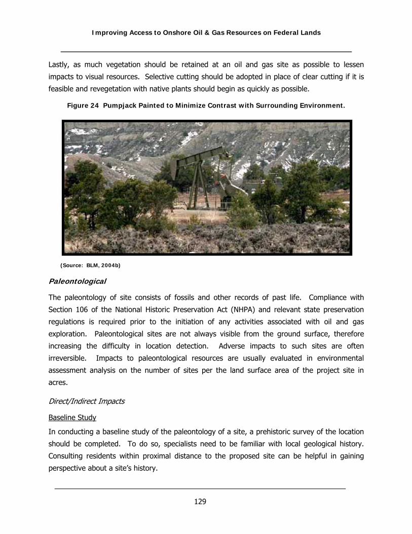
Improving Access to Onshore Oil & Gas Resources on Federal Lands
129
Lastly, as much vegetation should be retained at an oil and gas site as possible to lessen
impacts to visual resources. Selective cutting should be adopted in place of clear cutting if it is
feasible and revegetation with native plants should begin as quickly as possible.
Figure 24 Pumpjack Painted to Minimize Contrast with Surrounding Environment.
(Source: BLM, 2004b)
Paleontological
The paleontology of site consists of fossils and other records of past life. Compliance with
Section 106 of the National Historic Preservation Act (NHPA) and relevant state preservation
regulations is required prior to the initiation of any activities associated with oil and gas
exploration. Paleontological sites are not always visible from the ground surface, therefore
increasing the difficulty in location detection. Adverse impacts to such sites are often
irreversible. Impacts to paleontological resources are usually evaluated in environmental
assessment analysis on the number of sites per the land surface area of the project site in
acres.
Direct/Indirect Impacts
Baseline Study
In conducting a baseline study of the paleontology of a site, a prehistoric survey of the location
should be completed. To do so, specialists need to be familiar with local geological history.
Consulting residents within proximal distance to the proposed site can be helpful in gaining
perspective about a site’s history.

Improving Access to Onshore Oil & Gas Resources on Federal Lands
130
Surface Disturbance
Impacts to paleontological resources are evaluated on the number of sites per the land surface
area of the project site in acres. Impacts to paleontological resources have the greatest chance
of occurrence during the primary phases of development such as site preparation and
construction (USFS, 2001). Adverse effects to this resource can be caused by any variety of
ground disturbance associated with the construction of roads and well pads. The removal of
artifacts from their original location and disturbance of the site will destroy much of their value
(USFS, 2001). The position of the artifacts relative to their surroundings should be studied to
determine their age as well as the context in which they were originally used.
Erosion and Deposition
Increased erosional activity would remove artifacts from their surroundings and destroy much
of their value (USFS, 2001). Soil erosion would also likely make artifacts visible and, therefore,
making illegal artifact collection more likely. Increased soil deposition resulting from
construction activities associated with oil and gas development may provide protection for
paleontological resources, but would ultimately make them inaccessible and more difficult to
relocate (USFS, 2001). If artifacts are unearthed during construction, all development related
activities should cease (USFS, 2001).
Seismic Surveying
Ground disturbing geophysical surveys conducted off-road prior to oil and gas development can
also impact paleontological resources. Detonation of explosive charges associated with seismic
exploration may have an effect on the distribution and condition of artifacts in a surface artifact
scatter or the condition of the surface features (USFS, 2001).
Cumulative Impacts
Adverse cumulative impacts to site paleontology can occur via the increase of roads and access
ways from multiple development projects. Increased access can heighten vandalism, or
perhaps illegal artifact collection.
Mitigation
Mitigation of adverse impacts to paleontological resources would be best met through locating
those resources, achieved through comprehensive surveying, and then adjusting well pad and
access road siting to avoid them. For sites that can not be avoided, adverse effects can be
mitigated through data recovery, such as archeological excavation.

Improving Access to Onshore Oil & Gas Resources on Federal Lands
131
Geology
Geologic materials and geologic processes control or influence many aspects of the physical
environment, such as slope aspect; slope steepness; the areal extent of landforms and
associated vegetation; the distribution and composition of soil parent material; and the
structure and composition of vegetation (USFS, 2004). In terms of oil and gas development,
understanding the prominent geological features which define an area is important for
designing exploratory and production procedures, as well as assessing any potential subsequent
geology related impacts. Impacts to geological features during oil and gas development can
result when geological characteristics of an area are altered in a manner that cause changes to
local erosion conditions, transportation of sediment, landsliding properties (topography),
changes in stream channels or direct surface disturbance and the irretrievable commitment of
oil and gas resources (USFS, 2004). Soil type and its associated attributes for a specific area is
an important geologic component that requires important consideration since the characteristics
of soil are often directly related to the magnitude or types of observed impacts. As such, a
comprehensive discussion specific to soils is necessary to adequately explain the impact analysis
approach for soils and for this reason is detailed in an earlier subsection of this chapter.
Direct/Indirect Impacts
Baseline Study
Baseline information necessary for analysis of geologic impacts should include a descriptive
assessment of surface and subsurface geological features. A proper assessment of these
features will allow for more efficient use of the surface, extraction of minerals, and minimization
of impacts to the surface and subsurface. Preferably this assessment will be performed by a
geologist familiar with the area to allow for proper identification and analysis of appropriate
features that include underlying formations, unconsolidated surficial deposits, sedimentary
layers, subsurface salt movement, natural faulting or fracturing locations, and local topographic
relief characteristics such as canyons, cliffs, elevated plains, low plateaus, mesas, buttes,
arroyos, and valleys.
During this assessment phase certain questions should be asked. These can include, but are
not limited to: Will the project affect local landforms and physical landscapes? Will oil and gas
development affect other resource development such as the mining of coal or the development
of other subsurface mineral resources in the area? Will surface disturbance associated with the
construction of additional roads and well pads affect existing landslides and slope stability or
increase the likelihood of new slope movements? Will roads be necessary in steep topography?

Improving Access to Onshore Oil & Gas Resources on Federal Lands
132
Will injection of produced water affect the geologic stability of the subsurface? Are underlying
formations stable or do they contain natural fractures? Will extraction of water and oil or gas
cause any degree of subsidence?
These are important questions to consider because they can often affect surface planning
strategies and mineral extraction effectiveness. For example, sloping ground is typically leveled
using cut-and-fill construction methods when roads, well pads, or other facilities are built. The
amount of cut and fill material necessary to construct such surface facilities will proportionally
increase with the frequency and magnitude of slope(s) in the area (BLM and USFS, 2004). In
another example, localized structural deformation in some cases can cause fractures and, in
CBNG development for instance, may enhance coal bed permeability and enhance the
movement of water and gas through coal beds. Conversely, fractures may offset coal beds
against rocks with lower permeability and impede the movement of gas or water and slow
production (BLM and USFS, 2004). Natural subsurface fractures may enhance injection disposal
options of some deep formations, while fault displacement may enhance the interconnectivity of
subsurface zones enhancing migration pathways for across zones.
Surface Impacts
In general, surface or geologic impacts associated with facility development are considered
unavoidable and associated adverse effects, if any, will persist during the life of the project or
until reclamation of facilities. Management activities that involve earth-moving such as road
construction or overland vehicles to transport equipment and personnel have the most potential
to effect geologic resources. The potential effects vary depending upon the type, size, and
sensitivity of the resource and the magnitude of the ground disturbance (USFS, 2004). When
new wells are to be installed, the methods to analyze impacts should focus on the construction
and maintenance of access roads, wellpads, flowlines, and pipelines and the potential for these
types of facilities to erode, compact and rut soils, introduce nonnative construction materials,
and reduce soil permeability that may result in localized impacts. Special attention should be
paid to existing landforms since they may need to be altered or removed during energy
resource development, and in some cases, may not be able to be completely restored during
reclamation. In this situation the loss of these geologic features would be an irreversible and
irretrievable commitment of the surface geologic environment (BLM, 2003a).
The following are examples of additional geological issues that should be assessed or studied to
determine potential impacts to this resource.

Improving Access to Onshore Oil & Gas Resources on Federal Lands
133
• Construction of roads, well pads, and flowlines can result in disturbance to poorly-
drained soils that support riparian or wetland vegetation, the loss of long-term
productivity, and reduce potential for successful reclamation.
• Construction can disturb slopes, which would result in long-term erosion;
• Release of oil and gas or other contaminating and hazardous substances into the
environment would impact soils.
• Increased erosion rates or reduction in soil productivity and stability could prevent
successful reclamation with native species and composition.
• Material site development (gravel) can result in localized topographic changes to the
extent gravel is extracted.
• Development can alter naturally occurring rock outcrops and deposits where surface
exposures have been excavated to construct roads, drilling locations, or facilities.
Subsurface Impacts
In regards to mineral extraction, removed commodities or resources represent an irreversible
and irretrievable commitment of these nonrenewable resources, that once developed, are
consumed (BLM, 2003a). As such, subsurface geological resources are modified to the extent
that mineral or gas reserves are produced. Therefore, the assessment of the impacts to
geologic resources must consider the effect of committing these resources to development, the
potential for delays in the development of other geologic resources in proximity to these
resources, and the potential for mineral drainage issues of proximally located uncommitted
resources. Reservoir analysis can be used to assess the potential for drainage to occur, and
state and federal oil and gas regulations guide oil and gas development activities such that
resources are conserved during development and not wasted (BLM, 2003b).
Cumulative Impacts
Abandoned, ongoing and proposed oil and gas operations can adversely affect geologic
resources without proper planning. During the analysis phase, short-term impacts typically
result from geophysical exploration and short and long-term impacts occur from the
construction, maintenance and use of access roads, wellpads, flowlines or oil and gas pipelines
(NPS, 2004). More specifically, construction activities can cause compaction and rutting, reduce
permeability, and increase erosion and deposition of sediments that can alter the topography,
increase turbidity in streams, modify surface water flows and indirectly adversely affect

Improving Access to Onshore Oil & Gas Resources on Federal Lands
134
vegetation, and fish and wildlife (NPS, 2004). However, the cumulative effects on the surface
geologic environment can be minimized if proper techniques for well pad and facility siting,
construction, and reclamation are used.
The pattern of naturally occurring landforms can be altered wherever excavation occurs. The
topography and characteristic landforms of an area affected by construction can often be
restored during reclamation; however, an important consideration during the cumulative impact
analysis is that restoration typically can only approximate pre-existing conditions. For example,
because of the limitations of replacing “unbroken or in-place material” with loose material that
takes up more space, the same landscape form may not be obtained (NPS, 2004). Cumulative
impacts to the environment may vary depending on the type of reclamation effort and the
success of these efforts may not be known until several years after the restoration process.
Lastly, unplanned actions should be analyzed in the cumulative impacts assessment. These
actions can include wildfires, prolonged wet periods, or large storms that can destroy vegetation
or introduce excessive precipitation that can trigger slope movement (BLM and USFS, 2004). In
the case of slope movement or slope failure, for example, predicting the probability of
occurrence is difficult to do, as well as accurately reflect, because there occurrence are
dependent on many factors and typically are not quantifiable. Although impacts can be
minimized with properly implemented engineering and mitigation measures, potentially unstable
slopes subjected to the removal of vegetation or facility construction of drill pads, roads, or
other facilities can cause these controls to fail.
Mitigation
Mitigation measures to reduce impacts to geological resources are typically derived from
planned reclamation procedures, surface related avoidance practices, and by implementation of
sound engineering practices. The removal of fill materials and the re-contouring and re-
vegetation of disturbed areas can reduce soil erosion and re-establish surface drainage flows.
Surface stipulations established by the responsible federal agency or land owner can restrict
areas permitted for vehicular travel or geophysical exploration and thereby eliminate many of
the adverse impacts associated with their use. In geophysical exploration, for instance, hand-
held augers can be utilized in areas where vehicle access is prohibited (e.g. perennial wet or
saturated soils and unstable slopes) to reduce damage and unnecessary loss of vegetation
(NPS, 2004). Other options include the use of 3-D seismic minihole techniques that involve
drilling shallow shotholes in a cluster or tight linear pattern with a hand-held portable-drilling

Improving Access to Onshore Oil & Gas Resources on Federal Lands
135
tool. With this technique, equipment can be carried on foot or transported via helicopter and
thereby reduce adverse impacts from overland vehicle use.
The most effective mitigation measure for construction on unstable slopes is avoidance (BLM
and USFS, 2004). In situations where avoidance is not feasible, geotechnical engineers can
design stabilization measures such as subsurface drainage, retaining walls, and soil
reinforcement that can be incorporated in construction or reconstruction plans. Additionally,
wells pads can be constructed in areas defined by low topographical relief to reduce the risk of
landslides and erosion events. Lastly, appropriate and successful reclamation of existing access
roads and wellpads, for instance, can reduce overall cumulative impacts to geologic resources
and in many cases can beneficially impact soils.
Noise
Noise is generally defined as any unwanted sound. Noise at oil and gas sites results from
trucks and other equipment, drilling operations, and facilities. Assessing impacts from noise is
important as noise can be disruptive to humans and wildlife. With proper mitigation measures,
many of the expected impacts from noise can often be avoided.
Direct/Indirect Impacts
Baseline Study
The first step in impact assessment of noise is the description of existing noise conditions in the
project area to serve as a baseline study to which impacts can be prepared. This should include
noise levels and patterns as well as the sources of noise in the area. The attitudes towards
different noises of people who live in or use the area should be documented when applicable.
Identification and Assessment of Noise Impacts from Oil and Gas Development
Noise resulting from oil and gas operations can have a wide range of effects including:
• Noise can cause disturbance/annoyance of humans.
• Noise can cause disturbance/annoyance of wildlife.
• Hearing loss can result from long-term exposure to noise.
• Sleep loss can result from disturbing or annoying noises.
• Property can be devalued due to noise pollution.
• Noise can cause behavioral changes in wildlife.

Improving Access to Onshore Oil & Gas Resources on Federal Lands
136
Methods of Assessing Impacts from Noise
Assessing impacts from noise is important because noise can affect the health and well being of
humans and wildlife. Definitions of the following terminology are necessary to begin noise
impact assessment. The New York States Department of Environmental Conservation’s
document Assessing and Mitigating Noise Impacts identifies the five characteristics of
environmental effects of sound and human perceptions of sound as:
1. Sound Pressure Level: is the perceived loudness as expressed in decibels (dB) or A-
weighted decibel scale dB(A) which is weighted towards those portions of the
frequency spectrum, between 20 and 20,000 Hertz, to which the human ear is most
sensitive. Both measure sound pressure in the atmosphere.
2. Frequency: is the rate at which a sound source vibrates or makes air vibrate.
3. Duration: is the recurring fluctuation in sound pressure or tone at an interval; sharp
or startling noise at recurring interval; the temporal nature (continuous vs.
intermittent) of sound.
4. Pure tone: is composed of a single frequency. Pure tones are relatively rare in nature
but, if they do occur, they can be extremely annoying.
5. Equivalent Sound Level: is related to the average of the sound energy over time.
The Leq integrates fluctuating sound levels over a period of time to express them as a
steady state sound level. As an example, if two sounds are measured and one sound
has twice the energy but lasts half as long, the two sounds would characterized as
having the same equivalent sound level. Equivalent Sound Level is considered to be
directly related to the effects of sound on people since it expresses the equivalent
magnitude of the sound as a function of frequency of occurrence and time. By its
derivation Leq does not express the maximum nor minimum Sound Pressure Levels
(SPL) that may occur in a given time period. These maximum and minimum SPLs
should be given in the noise analysis. The time interval over which the Leq is measured
should always be given. It is generally shown in a parenthetic; Leq(8) would indicate
that the sound had been measured for a period of eight hours (NYDEC, 2001).

Improving Access to Onshore Oil & Gas Resources on Federal Lands
137
Sound Pressure Level is calculated as:
SPL = 20 [log10 (P/P0)]
where:
SPL = sound pressure level in decibels (dB)
P = actual sound pressure in microbars (10-6 atm)
P0 = reference pressure (0.0002 microbars, which is the threshold of hearing)
Noise impact assessment generally compares the proposed noise with actual noise levels.
Impacts will result from how the proposed noise differs from the character and/or SPL of the
current ambient noise (NYDEC, 2001). According to Assessing and Mitigating Noise Impacts, the basis of impact assessment relies on the identification of noise receptor locations, a
description/calculations of the ambient noise conditions at the receptor locations, and the
increase in SPL or changes in character that create noise impacts (NYDEC, 2001).
When determining the effects from noise, various environmental factors must be taken into
consideration. These factors can affect how noise travels, changing the significance of the
impact:
• Distance from Noise Source: Noise is lessened as one travels away from a noise
source. According to the Northern San Juan Basin Coalbed Methane project Draft EIS,
“noise decreases by 6 dBA with every doubling of distance from a source” (BLM and
USFS, 2004).
• Vegetation Present in the Area: Sound levels can be reduced up to 7 dB(A) when
vegetation is at least 100 feet in depth (NYDEC, 2001).
• Topographical Characteristics: Topographical characteristics, such as a hill, can
block noise travel between the source and receptors (NYDEC, 2001).
• Time of Year: Opportunity for impacts are greater during the summer when people
spend more time outside their homes and often keep windows open (NYDEC, 2001).
• Wind Direction and Speed: Receptors located upwind of sound can reduce sound
impacts, however, being located downhill will not increase the noise impact (NYDEC,
2001).
• Background Noise Level: A noise that is much louder or different than the
background noise level may be perceived as a worse impact than if noise is similar to
the background noise (NYDEC, 2001).
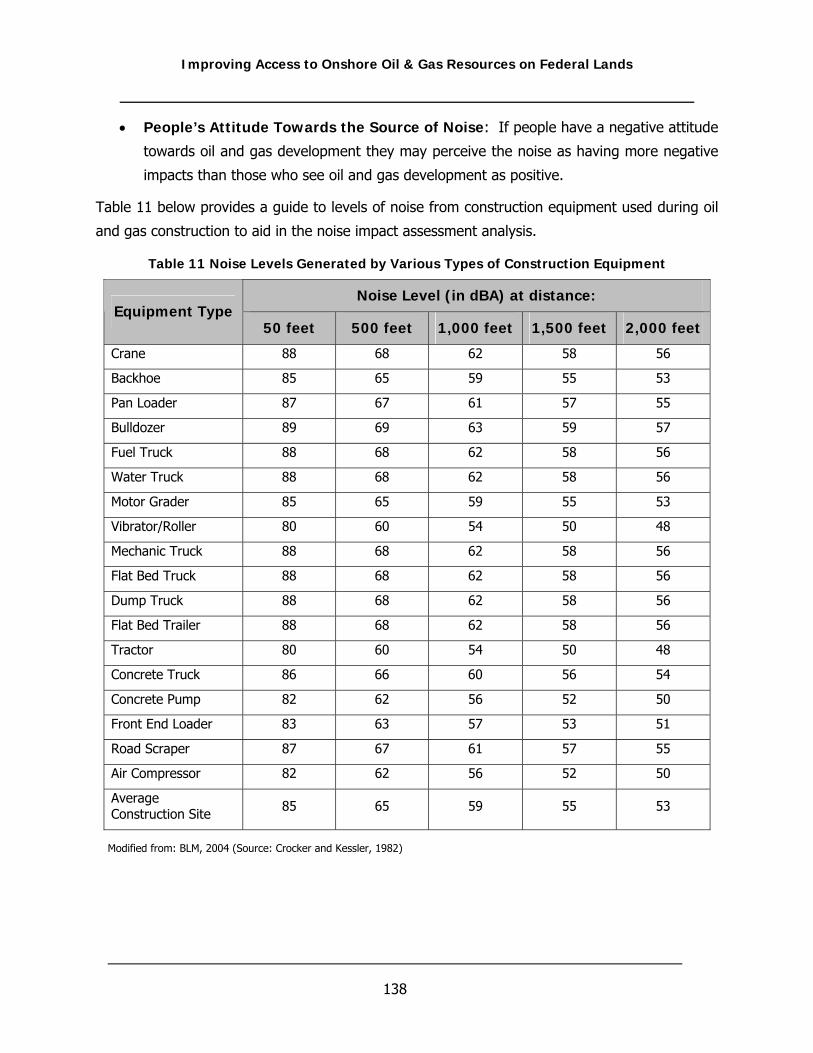
Improving Access to Onshore Oil & Gas Resources on Federal Lands
138
• People’s Attitude Towards the Source of Noise: If people have a negative attitude
towards oil and gas development they may perceive the noise as having more negative
impacts than those who see oil and gas development as positive.
Table 11 below provides a guide to levels of noise from construction equipment used during oil
and gas construction to aid in the noise impact assessment analysis.
Table 11 Noise Levels Generated by Various Types of Construction Equipment
Noise Level (in dBA) at distance: Equipment Type
50 feet 500 feet 1,000 feet 1,500 feet 2,000 feet
Crane 88 68 62 58 56
Backhoe 85 65 59 55 53
Pan Loader 87 67 61 57 55
Bulldozer 89 69 63 59 57
Fuel Truck 88 68 62 58 56
Water Truck 88 68 62 58 56
Motor Grader 85 65 59 55 53
Vibrator/Roller 80 60 54 50 48
Mechanic Truck 88 68 62 58 56
Flat Bed Truck 88 68 62 58 56
Dump Truck 88 68 62 58 56
Flat Bed Trailer 88 68 62 58 56
Tractor 80 60 54 50 48
Concrete Truck 86 66 60 56 54
Concrete Pump 82 62 56 52 50
Front End Loader 83 63 57 53 51
Road Scraper 87 67 61 57 55
Air Compressor 82 62 56 52 50
Average Construction Site 85 65 59 55 53
Modified from: BLM, 2004 (Source: Crocker and Kessler, 1982)

Improving Access to Onshore Oil & Gas Resources on Federal Lands
139
Cumulative Impacts
Other development in the location of the proposed oil and gas development can cause
significant cumulative impacts depending on the size and location of other development.
Cumulative impacts resulting from more than one area of development in proximity to each
other would be affected by the same factors as described above, including distance between
the development, wind, topographical characteristics, all affecting the severity of the impact.
Mitigation
Possible mitigation measures to reduce impacts from noise include:
• Locate sources further from noise receptors (BLM and USFS, 2004)
• Build fences, berms, or other structures, and enclose compressor stations to lessen
noise impacts on receptors (BLM and USFS, 2004)
• Use mufflers on machinery such as diesel engines (NYDEC, 2001)
• Limit hours that noisy operations may take place or plan for loud operations to occur
during the day when people are not sleeping (NYDEC, 2001)
• Notify people that a loud operation will soon occur (NYDEC, 2001)
Air Quality
Air quality in a given location is controlled primarily by the magnitude and distribution of
pollutant emissions and the regional climate (BLM and USFS, 2004) and is defined by pollutant
concentrations in the atmosphere as compared to a national or state ambient air quality
standard (BLM, 2003a). These standards represent the maximum allowable atmospheric
concentrations that may occur and still protect public health and welfare and include a
reasonable margin of safety to protect the more sensitive individuals in the population (BLM,
2003a). The federal Clean Air Act (CAA) of 1969 and its subsequent amendments establish air
quality regulations, including the National Ambient Air Quality Standards (NAAQS), and
delegates responsibility to states to enforcement these standards. The NAAQS represent
maximum acceptable concentrations that generally may not be exceeded more than once per
year, except the annual standards, which may never be exceeded. Currently, the EPA has
designated all areas of the United States as having air quality better than (attainment) or worse
than (nonattainment) the NAAQS (BLM, 2003a). A nonattainment designation generally means
that a primary NAAQS has been exceeded more than once per year in a given area.
Improving Access to Onshore Oil & Gas Resources on Federal Lands
140
Areas known (or assumed) to be attaining NAAQS are allocated to one of three “classes”. These
classes identify the level of effort that must be expended to maintain good air quality where it
already exists (USFS, 2004). Class I Areas (e.g., wilderness areas, national parks, self-classified
Indian Reservations, other sensitive areas designated by Congress) can receive only small
amounts of additional pollution. Class II areas can receive moderate increments of additional
air pollution, as long as neither a NAAQS violation nor a significant deterioration of resources is
anticipated. Class III areas can be designated to receive larger increments of additional
pollution, enough to bring attainment areas all the way down to (but not below) NAAQS.
Except for the 156 congressionally designated Class I Areas, all of the United States is
designated as Class II (USFS, 2004).
Direct/Indirect Impacts
Baseline Study
An inventory of pre-existing emission sources in a specific area or region, referred to as air
quality related values (AQRVs) (USFS, 2004), will facilitate a comparative analysis by the
responsible regulatory agency or operator to ascertain additional emissions and resulting
impacts, if any, that may be contributed from new oil and gas developments. For example, in
the Big Thicket National Preserve EIS, the baseline study indicated the Preserve was located in
two of the most polluted air sheds in the State of Texas and that the area already exceeded
NAAQSs (NPS, 2004). Baseline data to assess pre-existing air quality conditions is normally
available at appropriate state management programs. Typically, the pollutants of primary
concern for air quality analysis include volatile organic compounds (VOC), nitrogen oxides
(NOX), carbon monoxide (CO), nitrogen dioxide (NO2), Sulfur Dioxide (SO2), ozone (O3),
particulate matter less than 10 microns in diameter (PM10), and particulate matter less than 2.5
microns in diameter (PM2.5).
Baseline analysis for local or regional air quality conditions should also include an evaluation of
near and far field pollutant impacts specific from oil and gas production with the use of
dispersion modeling to determine if proposed emissions contribute to a predicted exceedance of
an ambient air quality standard (BLM, 2003a). Lastly, the analysis should incorporate the
effects of local topography to the transport of pollutants from specific source areas. For
example, in the mountainous western United States, topography is particularly important in
channeling pollutants along valleys, creating upslope and downslope circulation that entrain
airborne pollutants, and blocking the flow of pollutants toward certain areas (BLM and USFS,
2004).

Improving Access to Onshore Oil & Gas Resources on Federal Lands
141
Construction and Operational Practices
Air quality impacts resulting from oil and gas development, if present, are often the product of
normal oil and gas construction and operational practices. Although many scientific methods
are available to assess air quality impacts, more common approaches are dispersion models
(e.g. EPA Screen3 and ISCST3) or by use of CALMET/CALPUFF methods. Typically, air quality
impacts are classified as negligible and short-term for project elements associated with
construction and well drilling and testing, and negligible and long-term for project elements
associated with oil and gas production (USFWS, 2002). For instance, earth moving practices for
road or well pad construction can cause excessive dust emissions for a local environment;
however, upon completion of such construction activities, excessive dust production is
considerably reduced. However, as stated earlier, the extent of air quality impacts will be
dependent on regional climatic conditions (e.g., prevailing air flow) and existing air quality
conditions, as well as the nature of the source. Provided below is a summary of oil and gas
related practices or activities that should be evaluated during the air quality impact analysis.
• Combustive emissions due to the operations of mobile and stationary source equipment
and fugitive dust emissions (PM10) from earthmoving activities and the operation of
vehicles on both unpaved and paved surfaces
• Gas well production and the operation of associated gas-fired sources such as wellhead
compressors, water separator units, condensate tank heaters, dehydrators, and
compressor stations
• Operation of mobile source equipment for overburden and coal handling and stationary
coal handling equipment. Air quality impacts would occur from combustive and fugitive
dust emissions.
• Land use policies that would affect the level of off-road mobile sources and ground-
disturbing activities
• Accidental spills of volatile petroleum products resulting in emissions of hydrocarbons or
volatile organic compounds, and other pollutants such as hydrogen sulfide (H2S)
• Emissions from gas pipeline leaks
• Wind eroded dust
• Gas emissions and the effect on visibility levels

Improving Access to Onshore Oil & Gas Resources on Federal Lands
142
Project Duration
The amount of air pollution generated over the productive life of oil or gas wells depends on the
characteristics of the product and the production practices used (NPS, 2004). Typically, when
assessing air quality impacts, however, well development and associated production rates are
assumed to be constant on an annual basis. Under this scenario peak annual production and
emissions will occur at the end of the proposed projects duration (usually a 20-year period).
The important consideration here is that maximum predicted operational air quality impacts are
often based on maximum projected development. In many situations this method or analysis
approach does not accurately reflect development or its associated air quality impacts. More
commonly, actual development occurs in phases that results in lower air quality impacts at a
projects start-up with proportional increases as development advances.
Cumulative Impacts
To a certain extent, the degree of cumulative impacts to air quality within a local or regional
environment that will be contributed from oil and gas related projects are dependent on the
duration and type of the oil or gas project, the overall size of the project, in-place mitigation,
and pre-existing emission sources. Additionally, air quality impacts often change or are
distributed differently overtime as new operations are developed or while older operations are
plugged, abandoned, and reclaimed. Population levels over time can also change as well.
Increases to population growth can increase adverse impacts at the regional level (NPS, 2004).
In all cases, however, based on “reasonable, but conservative" assumptions, cumulative
impacts are required to be within applicable air quality standards (BLM, 2003b).
Mitigation
Proper maintenance of gasoline and diesel-fueled engines and use of low sulfur fuels are
important control measures that can be used to minimize exhaust emissions (NPS, 2004).
Pollution control devices, such as catalytic converters, should be used on exhaust gas to reduce
unnecessary emissions. Inspection and maintenance of production equipment such as flares
and treater facilities is also necessary to ensure that deteriorated components and equipment
are detected and replaced or repaired. In addition, using flareless flow-back units to capture
otherwise released gas instead of flaring the gas would lower emissions (BLM and USFS, 2004).
In terms of roads and wells constructed on soils susceptible to wind erosion, appropriate
surfaces should be utilized to reduce the amount of fugitive dust generated by traffic or other
activities, and dust inhibitors (i.e., surfacing materials, non-saline dust suppressants, water,

Improving Access to Onshore Oil & Gas Resources on Federal Lands
143
etc.) should be used as necessary on unpaved collector, local, and resource roads (BLM, 2003b;
BLM and USFS, 2004). Additional, operators could establish and enforce speed limits (15 to 30
mph) on all project-required roads in and adjacent to the project area (BLM, 2003b; BLM and
USFS, 2004).
Surface Disturbance
The footprint of drilling and production operations for oil and gas projects is variable and is
dependent upon the needs of the operator and the mutual objectives established by the
operator and managing agency and land owner. Furthermore, the land uses within any
producing area will also vary considerably and can include forest preserves, residential
communities, rangeland, and national parks. In any case, oil and gas development within a
given area must comply with the land use plans and policies adopted by federal, state, and
county governments. In addition, different land uses will often require operators to vary their
approach during the development process and in some instances, may require operators to vary
production practices to avoid impacts to existing land uses (ALL Consulting, 2004). Under these
varying circumstances the development of surface use plans will allow for more efficient use of
the land while balancing protection of important local resources by minimizing surface impacts.
Surface use planning is an important aspect of surface disturbance or land use impacts because
it can provide an opportunity for developers to work in cooperation with landowners to establish
scientifically sound and economically profitable development while maintaining existing land
uses or possibly facilitating future land use opportunities (ALL Consulting, 2004). For example,
the location of ponds, roadways, and multi-well pads can allow for the continuation of current
land uses while providing improvements to the landscape that would be beneficial to future
uses. Additionally, surface use planning can alleviate concerns that development will impact
cultural and wildlife resources, for example, through avoidance practices and noise reduction
technology. In most cases a surface use plan will constitute an important component of the
permit to drill application to specify measures that will minimize surface damage and
degradation of visual resources, as well as define actions that will not be detrimental to other
uses or properties.
Direct/Indirect Impacts
Baseline Study
Prior to assessing surface related impacts caused by oil and gas exploration or production
procedures, it is necessary to determine if the proposed project will be consistent with the

Improving Access to Onshore Oil & Gas Resources on Federal Lands
144
adopted land use plans of the area, if any, and if the proposed actions will conform with
associated policies of federal, state, and local agencies (BLM and USFS, 2004). Obviously then,
the first step is to determine the land’s current use conditions (e.g., agriculture, livestock,
national forest) followed by a preliminary evaluation to determine or predict how development
will affect this use (or resource). In all likelihood the easiest approach to assess potential land
use or resource impacts will be to compare proposed actions to existing oil and gas projects
similar in nature. Additionally, review of federal and state guidance documents and scientifically
sponsored studies, as well as discussions with the managing agency, will allow for a more
informed project design to facilitate the minimization of impacts.
Another important consideration during this preliminary process is surface ownership as land
use impacts will vary depending on surface and mineral ownership at specific locations. For
example, private landowners have full control over the location of oil and gas facilities for
properties in which they hold surface and mineral rights. In such situations, the owner may
have certain surface stipulations that will force certain concessions in facility location, access, or
aesthetic requirements. Conversely, landowners that do not own the mineral rights cannot
prevent mineral lessees from drilling a well on the property, but will typically be given
opportunities to participate in developing surface use plans and defining needs or surface
restrictions (BLM and USFS, 2004).
Lastly, in most cases when federal agencies are involved, inspection of the proposed surface
disturbing locations are delineated prior to permit approval to identify sensitive areas and
environmental consequences associated with the proposal at each specific location (BLM and
USFS, 2004). Thus, operators should take an adaptive and flexible approach to account for
changes in initial design plans that may be required by the authorizing agency. BLM’s POD
requirements for CBNG development in Montana or Wyoming is an example of this permit and
inspection process.
Construction Related Impacts
A surface related impact has the potential to affect many resources in various manners and,
therefore, requires specific discussion per resource. Although this type of discussion is
considered beyond the scope of this particular section, analysis of impacts per resource
pertinent to this subject is provided in the appropriate resource discussions in this chapter.
Surface disturbance analyses for a specific area should be supported by technical data and
reasonable assumptions and should be described in terms of type, duration, severity, and aerial
extent (BLM, 2006a). Direct surface related impacts are quantifiable and will result from

Improving Access to Onshore Oil & Gas Resources on Federal Lands
145
construction of well pads, access roads, pipelines, compressor stations, disposal wells,
impoundments, and use of heavy equipment. Obviously, calculating and thus analyzing the
extent of surface disturbance for any project area will be dependent on several factors that can
include the density or length of proposed new roads, width and length of ROWs that may
include pipelines, and the estimated size of well pads. Additionally, the duration of the project
will affect surface disturbance calculations as well since, under most circumstances surfaces are
reclaimed when certain facilities are no longer needed (BLM and USFS, 2004). The following
formulas can be used to calculate surface disturbance as described by the BLM (2006).
Gross surface disturbance = current disturbance + future disturbance Net surface disturbance = current disturbance + future disturbance – reclamation
In general, oil and gas development can potentially affect existing land uses in several ways.
First, surface disturbances during both the construction and operational phases of development
can cause displacement of some existing land uses and will typically occur for the life of the
project. Secondly, land uses near oil and gas facilities can be affected by intrusive effects. For
example, vehicles on existing roads will generate additional noise, dust, and traffic. These
effects may conflict with nearby land uses, primarily residential properties (BLM and USFS,
2004). Lastly, oil and gas development may affect growth patterns, possibly resulting in
conflicts with local goals for future land use. As stated earlier, to properly assess and qualify
each particular land use disturbance will require an understanding of existing lands uses, local
policies and perceptions, planned mitigation and an estimate of the surface impact.
Watersheds
A recent trend by federal agencies is to manage resource programs on a watershed basis.
Analysis of information on surface disturbances by watershed is important as it can be used to
predict short and long term impacts on soils, sediment yields, habitat fragmentation, cultural
resources, and surface water quality (BLM, 2003a). In terms of sedimentation, surface
disturbance, especially bare soil on unpaved roads, is a major contributor to changes in
sediment yield in a watershed (BLM, 2003a). One limiting factor when analyzing the effects of
sedimentation on watersheds is that known locations of new wells, roads, pipelines,
compressors, etc. are needed for proper assessment of impacts. In many cases this type of
information is either not available or as is more common, can frequently change to
accommodate project needs, land uses, or regulatory requirements. In general, however, it can
be concluded that areas with the highest density of development, the least ground cover, and
the most erodible soils will generate the highest sediment yields. Therefore, the analysis should

Improving Access to Onshore Oil & Gas Resources on Federal Lands
146
focus on quantifying changes in surface disturbance, amount of vegetation disturbed, and road
density, with the assumption that increased sediment yields will have proportional increases in
watershed parameters (BLM, 2003a).
Cumulative Impacts
To adequately address cumulative impacts resulting from surface disturbances, a sum of the
gross and net area of potential surface disturbed as a result of oil and gas activity by the
number of years of expected operations should be calculated. This calculation should not only
address anticipated future activity, but also existing activity and anticipated changes in existing
activity. For example, existing activity such as plugging a well and subsequent reclamation of
the well site will serve to reduce overall net surface effects of oil and gas activity (BLM, 2006a).
The analysis of cumulative impacts should also address impacts to visual resources, noise, dust,
recreation, transportation, and potential effects to residential property values, land use
conflicts, land displacement and associated benefits that may be achieved from the
implementation of BMPs.
Mitigation
It is likely that erosion and sedimentation will result from initial surface disturbance. However,
realized impacts can be reduced once well pads, roads, and pipelines are stabilized by seeding
and by proficient use of surface water controls and other BMPs (BLM, 2003a). For instance, in
CBNG development not all subsurface completions require additional surface locations and,
subsequently, additional land disturbing activities. Additionally, disposal and deep tests wells
can be placed on pads that also accommodate producing wells. There are a wide variety of
control measures that can be utilized on oil and gas projects to control impacts that may arise
from surface disturbing practices. Although the successful and appropriate implementation of
these control practices will vary per situation, in most cases these controls can be established
and monitored with minimal project costs. Below is a list of some of the control measures that
are currently be used in the oil and gas industry.
• Use of directional drilling to avoid or minimize land use conflicts and reduce surface
impacts
• Fencing of allotments into pastures to control cattle distribution
• Developing stock ponds
• Construction of erosion control structures to protect watersheds

Improving Access to Onshore Oil & Gas Resources on Federal Lands
147
• Immediately reseed depleted or abounded areas
• Establishment of noise and visual ordinances
• Construct fences and cattle guards to reduce land displacement issues
• Immediately repair or replace any improvements damaged by project implementation
• Protect or avoid all permanent monitoring stations
• Minimize road construction to all extent possible by utilizing existing roads
• Avoid use of heavy equipment during periods of heavy rain
• Avoidance of construction activities is sensitive habitats (e.g., wetlands, riparian, critical
habitat, etc.)
D. HUMAN AND MANAGEMENT RESOURCES
Following is a discussion of the human environment and management resources group
consisting of socioeconomic, Native American concerns, and cultural resources.
Socioeconomic
Socioeconomic impacts encompass social and economic effects in areas where oil and gas
exploration and production is proposed. The “Gillette Syndrome” is a term that was coined in
1974 to describe the social and economic effects that can occur in a community due to rapid
population growth (Kohrs, 1974). In addition to changes in population and population
demographics, the Gillette Syndrome also refers to changes in tax revenue, crime rates, mental
health, social and community bonds, cost of living, the need for government services, and
more. In addition to researching data to predict future impacts, it is important that
socioeconomic analysis also consider “softer” data such as the attitudes of residents in an area
to changes in their region. Socioeconomic impacts can encompass many different topics;
therefore, it is important to focus on the most significant potential impacts, even when these
impacts are difficult to quantify (DOC, 1994).
Direct/Indirect Impacts
Baseline Study
The first step in socioeconomic impact assessment is the description of existing socioeconomic
conditions in the project area to serve as a baseline study to which impacts can be compared.
The following list from A Guide to Social Impact Assessment in the Oil and Gas Industry

Improving Access to Onshore Oil & Gas Resources on Federal Lands
148
published by the International Petroleum Industry Environmental Conservation Association
(IPIECA) outlines data sources useful for completing a baseline study. Data includes census
and other quantitative data, as well as qualitative interview techniques to determine how people
feel about their community and the issues that arise from development proposals.
• Secondary Data Sources: includes official material such as maps, censuses,
government records, research reports, social needs assessments, and historical texts.
Such data may need to be updated or augmented by field survey data collected by the
social impact assessment study team.
• Qualitative Interview Techniques: provides insight into how people perceive
themselves and how their community organization and leadership work together.
Interviews take into account preferences and expectation regarding overall project
benefits, specific mitigation measures, compensation and community development
needs. Qualitative techniques can also be used to fill gaps in baseline data surveys
which might have missed or understated. They can also enhance and verify quantitative
data.
• Quantified Data: is often collected on such parameters as household assets, income
streams, expenditures, vulnerable individuals or groups, health, education, skills of the
labor force, etc. Quantitative data allow for effective assessment of potential project
impacts over times. Reliable quantitative data also provide a sound basis to challenge
unfounded claims and future disputes concerning project impacts. However, quantified
data collection should focus on what really counts rather than what is easy to count.
• Participatory Rural Appraisal: the participatory approaches suggested by the Work
Bank can be used to share learning between local people and companies. Experience
suggests that the quality of baseline data collection can be enhanced by the use of
appropriate participatory approaches, particularly in Greenfield sites where the company
has a limited understanding of the stakeholders.
• Supply-chain Analysis: is helpful at an early stage of a project. Assessing the
inventory of goods and services that a project will requires for the development of
opportunities for local people or local businesses (IPIECA, 2004).
Impacts to socioeconomics will typically vary during the construction phase and during
operations for the life of the project. The following can be used to aid in the identification and
assessment of population impacts from oil and gas development:

Improving Access to Onshore Oil & Gas Resources on Federal Lands
149
• Changes in population demographics, including an increase or decrease in population
and a change in the make up of the population. When oil and gas development begins
in an area, this can sometimes result in an influx of men who relocate to the area for
work. Depending on the local population, the number of people brought into an area for
oil and gas activities can be negligible, or a significant change.
• Change in need for government services resulting from a population change, such as
increased need for schools, water, power, health care, and an increase in the use of
roads (IPIECA, 2004)
• Economic impacts, including increased county revenue from oil and gas development,
increased employment opportunities in both the oil and gas industry and other sectors,
such as an increased need for teachers or nurses (IPIECA, 2004).
• Impacts to a community’s way of life, including community attitudes and community
values (IPIECA, 2004).
• Impacts to different population groups, including minorities, low-income populations,
and the elderly.
Methods of Assessing Socioeconomic Impacts
Assessment of socioeconomic impacts relies upon a variety of different methods. Some aspects
of socioeconomic impact assessment can be more difficult to quantify, however, it is important
to focus on the most relevant and significant impacts rather than those that are easiest to
assess (DOC, 1994).
A common way to assess socioeconomic impacts from oil and gas development is to compare
the proposed development to similar development in another area. Similar scale development
at a similar location provides insight into which impacts may occur from proposed actions.
Other methods, as outlined in the document from the Interorganizational Committee on
Guidelines and Principles for Social Impact Assessment entitled Guidelines and Principles for Social Impact Assessment are:
• “Straight-line trend” projects: taking an existing trend and simply projecting the
same range of change into the future.
• Population multiplier methods: each specified increase in population implies
designated multiples of some other variable, e.g. jobs and housing units.

Improving Access to Onshore Oil & Gas Resources on Federal Lands
150
• Scenarios: (1) logical - imaginations based on construction of hypothetical futures
through a process of mentally modeling the assumptions about the variables in
question; and (2) fitted empirical - similar past cases used to analyze the present case
with experts adjusting the scenario by taking into account the unique characteristics of
the present case.
• Expert testimony: experts can be asked to present scenarios and assess their
implications.
• Computer modeling: involving the mathematical formulation of premises and a
process of quantitative weighing of variables.
• Calculation of "future foregone": a number of methods have been formulated to
determine what options would be given up irrevocably as a result of a plan or project,
e.g., river recreation and agricultural land use after the building of a dam.
As discussed in the Baseline Study section, a wide variety of socioeconomic data is available,
ranging from public scientific literature, to secondary sources such as the census, and lastly
primary sources such as interviews with local residents who may have a unique insight into
potential impacts from the proposed action (DOC, 1994). When there are data gaps, however,
it is more important to identify significant impacts than to only include impacts in the analysis
that can be well quantified. It is important that a trained social scientist address impacts that
do not have much data to complete an analysis (DOC, 1994).
Land Use
Land use impacts result from changes in how land is managed due to oil and gas development.
Changes in land uses can result in both positive and negative impacts to residential,
agricultural, and industrial areas.
Direct/Indirect Impacts
Baseline Study
Prior to completing an impact analysis, a baseline study of land management to which impacts
can be compared needs to be completed. This should include data regarding various land uses
including agriculture, industry, residential, commercial, as well as any land use plans or other
planning documents governing the locality.
Land use impacts result from changes to how land is managed due to oil and gas development.
Impacts include:

Improving Access to Onshore Oil & Gas Resources on Federal Lands
151
• Loss of land used for agriculture or industry due to oil and gas development. However,
some land owners may want oil and gas development in the event that oil and gas
development would be more profitable than their current operations (BLM, 1997).
• Changes in land use due to impacts from the effects of oil and gas development such as
the loss of recreational use due to increased noise or negative visual impacts or
disruption of residential areas (BLM, 1997).
• Increase in traffic due to oil and gas construction and maintenance (BLM, 1997).
• Falling out of conformance with a land use plan that is implemented in a region due to
oil and gas development.
Methods of Assessing Land Use Impacts
The primary method to assess impacts to land use is the determination of how much land will
be managed for a different purpose due to proposed oil and gas development. This would
include how many acres of agriculture, land used for industry, or residential areas are lost.
Changes in land uses due to impacts from oil and gas development, such as loss of recreation
or disruptions to residential areas, can be estimated after impact predictions about other
resources are established, such as visual resources and impacts from noise. The number of
homes impacted by oil and gas development should be estimated when applicable. Analysis will
vary between proposed actions based on the current land uses in an area and population.
The amount of traffic due to oil and gas development should be calculated based on the
number of wells. There will be more vehicle trips expected during the construction phase than
for maintenance.
All land use plans and other planning documents that govern a region should be reviewed to
ensure that any proposed development is in within their guidelines as should any special
designation land classifications.
Cumulative Impacts
Cumulative impacts analysis should discuss all other development that will result it changes to
land use, especially those affecting agriculture, recreation, and residential areas. The
cumulative impacts of oil and gas development and other developments occurring in the area
can together have significant impacts to the area, and therefore must be analyzed.

Improving Access to Onshore Oil & Gas Resources on Federal Lands
152
Mitigation
Mitigation measures to avoid or lessen impacts from land use changes include:
• Discussing oil and gas operations with land owners that will be affected by new
development. This will give land owners an opportunity to understand the details of
development as well as provide suggestions to avoid impacts.
• Minimize impacts from increased traffic by utilizing back roads for vehicles traveling to
oil and gas sites and by crews carpooling (BLM, 1997).
Environmental Justice and Native American Concerns
According to the Environmental Protection Agency, “Environmental Justice is the fair treatment
and meaningful involvement of all people regardless of race, color, national origin, or income
with respect to the development, implementation, and enforcement of environmental laws,
regulations, and policies.” (EPA, 2006b). In the impact analysis project, environmental justice is
analyzed to ensure that low-income and minority populations do not bear a disproportionate
burden of impacts from oil and gas development and that these population groups have their
needs adequately addressed. Due to the fact that analysis is similar for environmental justice
and Native American concerns they are grouped together in this document, however, many
EISs analyze these issues separately.
Direct/Indirect Impacts
Baseline Study
Prior to completing impact analysis of environmental justice and Native American concerns, a
baseline study of low-income and minority groups, including Native Americans, needs to be
completed. Information about population, income, economic status, where these groups live,
etc. needs to be compiled so that changes due to oil and gas development can be analyzed.
Identification and Assessment of Environmental Justice Impacts and Impacts to Native Americans from Oil and Gas Development
Environmental justice impacts and impacts to Native Americans are similar to socioeconomic
impacts (see socioeconomic section), however there are some additional considerations when
analyzing impacts to low-income and minority populations:
• Disproportionate human health and/or environmental impacts to low-income or minority
groups

Improving Access to Onshore Oil & Gas Resources on Federal Lands
153
• Low-income or minority populations may not be adequately represented in the scoping
process, resulting in development that has adverse impacts on these population groups
• Increased population and traffic on Native American reservations (by Native Americans
or other races)
• Change, often an increase, in revenue or economic gains for low-income or minority
populations
• Impacts to traditional cultural properties or land used by Native Americans for religious
or cultural purposes
• Impacts to wildlife that is traditionally hunted or vegetation that is traditionally collected
by Native Americans
Methods of Assessing Environmental Justice Impacts and Impacts to Native Americans
Methods of assessing impacts regarding environmental justice and Native American concerns
are similar to those from the socioeconomic section. Data regarding low-income and minority
populations, including their population, income, where these groups live, etc., should be
analyzed to determine if oil and gas development will affect these groups any differently than
higher income and non-minority groups. The range of effects needing to be considered
includes environmental, human health, and economic impacts. Interviews with low-income and
minority persons are necessary because these groups may be underrepresented during the
scoping process. When considering Native American concerns, these interviews can determine
where areas of religious or cultural significance are so that impacts to these areas can be
specifically analyzed. This is also true for wildlife and vegetation that are traditionally harvested
by Native Americans.
Economic analysis, as conducted for socioeconomic impacts, should be considered to determine
if low income or minority groups would suffer any disproportionate negative consequences
when compared to other groups in the area.
Cumulative Impacts
Other development in the area should be analyzed to determine if their impacts, combined with
the impacts from the proposed oil and gas development, will disproportionately affect low-
income and minority communities.

Improving Access to Onshore Oil & Gas Resources on Federal Lands
154
Mitigation
In order to prevent or avoid disproportionate impacts to low-income and minority communities,
discussions should begin with these affected groups. By facilitating dialogue, NEPA specialists
will ensure that issues important to these groups are not overlooked even if these groups are
not as active during the scoping process. Once the potential impacts are known, steps can be
taken to alter or relocate certain aspects of development to avoid severe or disproportionate
impacts.
Cultural Resources
Cultural resources are best described as material remains of, or the locations of past human
activities, including sites of traditional cultural importance to both past and contemporary Native
American communities (ALL Consulting, 2004); whereas, paleontological resources consists of
fossils and other records of past life. Section 106 of the National Historic Preservation Act
(NHPA) requires an inventory prior to the commencement of construction or other surface
disturbing activities for both of these resources if federal involvement is present either in terms
of surface or mineral estate, federal funds, federal grant, or federal license. In addition,
consultation with the Advisory Council on Historic Preservation and state historic preservation
officers (SHPOs) is required by law and regulation. In many cases, regulations and
management policies also require consultation with Native Americans and other concerned
ethnic groups, other federal agencies, state and local governments, and other interested
parties.
Direct/Indirect Impacts
Baseline Study
Potential impacts to paleontological and cultural resources, either by removal or degradation in
value, are often related to the location and degree of surface disturbance within any given
project area. To adequately assess impacts to these resources requires the identification of
potential sites within a specific location through examination of existing records, field surveys,
interviews, subsurface excavations and inspection of ethnographic materials for areas that are
proposed for disturbance on federal (or state) lands (BLM and USACE, 1999).
The baseline study for these resources should include delineation of planned surface
disturbance activities (e.g., roads, impoundments, heavy equipment) that will provide resource
specialists with the information necessary to develop appropriate inventory strategies and
subsequent establishment of “protective” corridors. Additionally, baseline evaluations should

Improving Access to Onshore Oil & Gas Resources on Federal Lands
155
include investigation of soils and geomorphology, especially in areas where this information is
limited, as the occurrence of unexpected discoveries is heightened under these conditions (BLM
and USACE, 1999). Lastly, the assessment of impacts should not only include the inventory of
physical artifacts, but should also include surveys of landscape's period(s) of historical
significance and the features, patterns, and context contributing to its significance (NPS, 1998).
For example, the physical setting of a site is a key component in its eligibility for the National
Register of Historic Places (BLM and USFS, 2004).
Operators of recent oil and gas developments within the Powder River Basin have recognized
that the use of block surveys verses site or route specific surveys have great benefits with their
project schedules and local Tribes and special interest groups. The use of block surveys
prevent the repetitive surveying of routes or pads sites when these are moved due to the
discovery of cultural resources. Furthermore, consultation efforts with local tribes or special
interests groups are enhanced by the area knowledge gained verses the discovery of a single
site or handful of sites. Block surveys are recommended by the BLM Miles City Field Office for
all CBNG proposed PODs.
Surface Disturbances
Direct impacts to paleontological and cultural resources are evaluated on the number of sites
per the land surface area (ratio) which are contained within the boundaries of a project
location. Impacts to these resources have the greatest chance of occurrence during the
primary phases of development such as site preparation and construction (USFS, 2001; BLM,
2003b). Activities that involve the use of heavy equipment (road construction, well drilling, pad
construction, pipeline and utility placement, etc.) that result in changes to the natural landscape
cause the most disturbance and have the greatest effect on paleontological and cultural
resources (BLM, 2003b). Additionally, detonation of explosive charges associated with seismic
exploration may have an affect on the distribution and condition of artifacts in a surface artifact
scatter or the condition of the surface features (USFS, 2001; NPS, 2004). The position of the
artifacts relative to their surroundings should also be assessed for impacts to determine their
age as well as the context in which they were originally used.
Erosion and Deposition
Increased erosion or changes to vegetation warrants impact assessment for these resources
since erosion events can change the characteristics and integrity of a site, remove artifacts from
their surroundings, and destroy much of their value (USFS, 2001; BLM and USFS, 2004). Soil
erosion would also likely unearth some artifacts and; therefore, potentially make impacts from
Improving Access to Onshore Oil & Gas Resources on Federal Lands
156
illegal artifact collection more pronounced. Conversely, increased soil deposition resulting from
construction activities associated with oil and gas development may provide protection for
cultural or paleontological resources but would ultimately make them inaccessible and more
difficult to relocate (USFS, 2001).
Other Indirect Impacts
Indirect effects to cultural or paleontological resource require close evaluation during the
assessment phase because they are not always as obvious or immediate as direct effects and
can include effects that occur off site from the areas of construction and operation (BLM and
USFS, 2004). Indirect physical effects to resources can include deterioration of structures or
rock art from vibration, dust, or exhaust produced by construction or operation (BLM and USFS,
2004; BLM, 2003b). If the setting and feeling of a site are essential elements of its importance,
visual or auditory intrusions or deterioration of the local environment would also cause indirect
effects to the aesthetic quality of the site. Some indirect effects such as visual and auditory
intrusion or acceleration of deterioration caused by vibration may extend a half-mile or more
from the source, but are still essentially local. Lastly, some emphasis should be placed on
hydrocarbon spills since the ability to get good carbon dating from some cultural or
paleontological resources can be affected (USFWS, 2002).
Cumulative Impacts
In many cases impacts to cultural or paleontological resources are irreversible and, thus, can
result in adverse cumulative impacts. The Advisory Council on Historic Preservation regulations
implementing Section 106 of the NHPA (36 CFR 800) include a definition of adverse effect with
respect to cumulative effects on significant historic properties. In terms of NEPA, adverse
effects include reasonably foreseeable effects caused by the preferred alternative that would
occur later in time, that would be farther removed in distance, or that would be cumulative (36
CFR 800.5). A determination of no adverse effect means that there is an effect, but the effect
would not diminish in any way the characteristics of the cultural resource that qualify it for the
National Register (BLM, 2003b).
Mitigation
Specific plans to mitigate potential impacts to cultural and paleontological resources should be
identified and completed prior to project implementation. These plans should be developed in
consultation with the SHPO, affected Tribes, other consulting parties and, if applicable, the
private surface owner (BLM, 2003b). Mitigation of adverse impacts to cultural and

Improving Access to Onshore Oil & Gas Resources on Federal Lands
157
paleontological resources is best achieved by locating resources through comprehensive
surveying and then adjusting well pad and access road siting to avoid them, as directed by
federal mandate (BLM and USFS, 2004). For sites that can not be avoided, adverse effects can
be mitigated through data recovery, such as archeological excavation. In situations when
exploratory or development procedures unearth previously undiscovered resources, enforceable
mitigation would require that work be stopped in the area of discovery until consultation with
the SHPO/tribal historic preservation officer and the Advisory Council on Historic Preservation
can be performed (BLM, 2003b; USFS, 2001; NPS, 1998). Appropriate and responsible action
would be determined by these agencies and coordinated with operators and/or landowners.

Improving Access to Onshore Oil & Gas Resources on Federal Lands
158
THIS PAGE INTENTIONALLY LEFT BLANK

Improving Access to Onshore Oil & Gas Resources on Federal Lands
159
APPENDIX A
SWANSON RIVER OIL & GAS FIELD CASE STUDY

Improving Access to Onshore Oil & Gas Resources on Federal Lands
160
THIS PAGE INTENTIONALLY LEFT BLANK
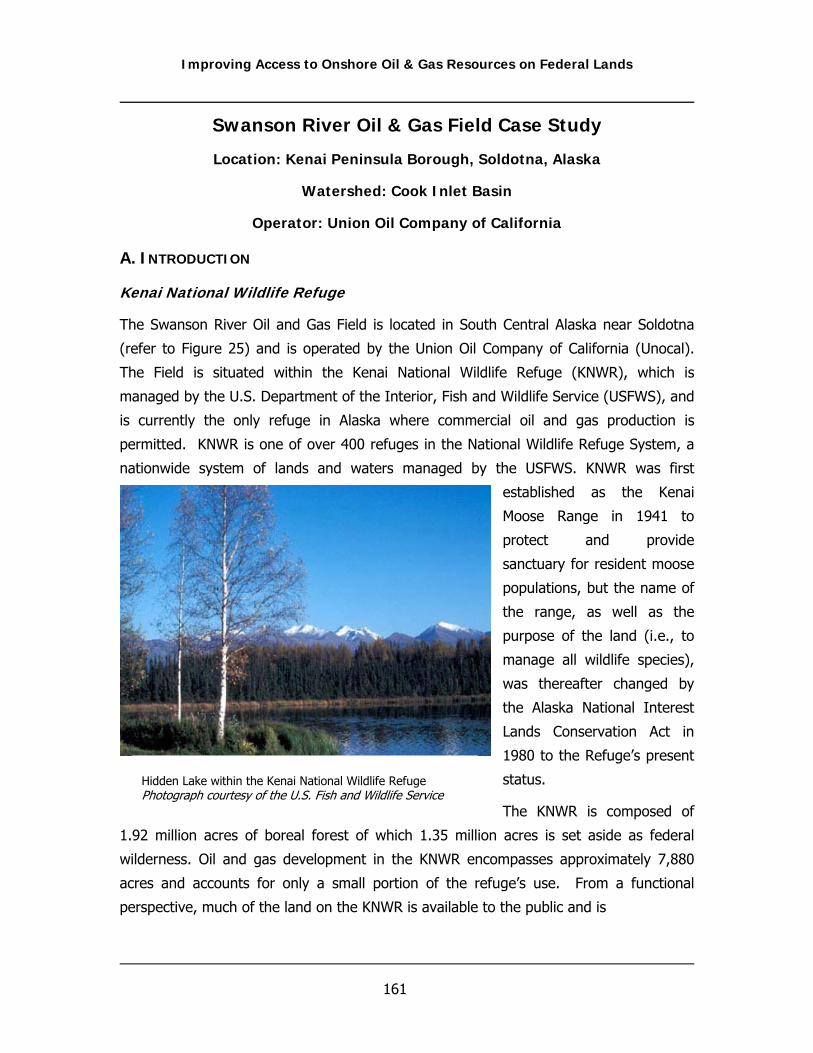
Improving Access to Onshore Oil & Gas Resources on Federal Lands
161
Swanson River Oil & Gas Field Case Study
Location: Kenai Peninsula Borough, Soldotna, Alaska
Watershed: Cook Inlet Basin
Operator: Union Oil Company of California
A. INTRODUCTION
Kenai National Wildlife Refuge
The Swanson River Oil and Gas Field is located in South Central Alaska near Soldotna
(refer to Figure 25) and is operated by the Union Oil Company of California (Unocal).
The Field is situated within the Kenai National Wildlife Refuge (KNWR), which is
managed by the U.S. Department of the Interior, Fish and Wildlife Service (USFWS), and
is currently the only refuge in Alaska where commercial oil and gas production is
permitted. KNWR is one of over 400 refuges in the National Wildlife Refuge System, a
nationwide system of lands and waters managed by the USFWS. KNWR was first
established as the Kenai
Moose Range in 1941 to
protect and provide
sanctuary for resident moose
populations, but the name of
the range, as well as the
purpose of the land (i.e., to
manage all wildlife species),
was thereafter changed by
the Alaska National Interest
Lands Conservation Act in
1980 to the Refuge’s present
status.
The KNWR is composed of
1.92 million acres of boreal forest of which 1.35 million acres is set aside as federal
wilderness. Oil and gas development in the KNWR encompasses approximately 7,880
acres and accounts for only a small portion of the refuge’s use. From a functional
perspective, much of the land on the KNWR is available to the public and is
Hidden Lake within the Kenai National Wildlife Refuge Photograph courtesy of the U.S. Fish and Wildlife Service

Improving Access to Onshore Oil & Gas Resources on Federal Lands
162
Figure 25 Cook Inlet Oil & Gas Fields
Relative location of the Swanson River Oil & Gas Field in the Cook Inlet Basin
Figure courtesy of the Alaska Department of Natural Resources, Division of Oil & Gas.

Improving Access to Onshore Oil & Gas Resources on Federal Lands
163
predominately maintained by the USFWS for primitive recreational use. The refuge maintains 13
campgrounds and harbors many wildlife species that include brown and black bears, caribou,
Dall sheep, mountain goats, wolves, lynx, moose, wolverines, eagles, and thousands of
shorebirds and waterfowl.
Swanson River Oil & Gas Field
The Swanson River field is Alaska’s first oil and gas field and in the minds of many, is the
historical catalyst for Alaska becoming the 49th state (Kenai Peninsula Borough, 2004). Oil in
the field was discovered by Richfield Oil Corporation in 1957 at a depth of 11,000 feet with a
discovery well flow rate of approximately 900 barrels a day (Alaska Department of Natural
Resources, 2004). The first major gas discovery occurred two years later by Unocal and the
Ohio Oil Company as a by-product of the oil development (Alaska Department of Natural
Resources, 2004). Swanson River has had three unit operators since 1957: Chevron USA (1957-
1986); ARCO Alaska, Inc. (1986-1992); and Unocal Corp. (1992 to present).
After the Swanson River
finding, additional wells
were developed in Cook
Inlet and more leases were
approved throughout the
basin. By 1959, 187,000
barrels of crude oil were
produced annually in Cook
Inlet (Alaska Department of
Natural Resources, 2004).
In 1969, the Swanson River
field observed its highest
oil production with 40,000
bbl/day. Early reservoir
estimates conducted by the
USGS projected a total of
437 million recoverable barrels of oil in the Swanson River field. In 1998, the field’s cumulative
production since discovery exceeded 225 million barrels, or in excess of over 50 percent of the
original oil-in-place estimates (Frates, 1999).
Well Site at Swanson River

Improving Access to Onshore Oil & Gas Resources on Federal Lands
164
As additional fields were discovered in the Kenai Peninsula area, surrounding markets for gas
were developed to supply heat and generate electricity. By 1984, net annual natural gas
production reached 217 billion cubic feet (bcf) per year, and peaked at 223 bcf in 1996 (Alaska
Department of Natural Resources, 2004). As of 1999, approximately 80 million cubic feet of gas
is transported daily to the Unocal Chemical Plant (Frates, 1999). All remaining gas is reinjected
for formation pressure maintenance. Historically, the Swanson River field has been a major net
gas producer in Cook Inlet, but more recently, as production rates have steadily declined, the
Field is expected to primarily function as a gas storage facility (Alaska Department of Natural
Resources, 2004).
As recently as 2003, the Swanson River oil and gas field was composed of 52 oil producing
wells and nine gas producing wells, as well as one water and one gas injection well. As of May
2005, the field produced 13 thousand cubic feet per day (mcf/day) of natural gas (which is
supplied to local utilities), 4500 gallons of propane, and 1,300 barrels per day (bbls/day) of oil
and consists of 26 active wells, seven which are gas, and two class II UIC wells. Produced
water production has slowly decreased from its high (14,000 bbls/day) to its current production
of 6,000 bbls/day. From a cumulative perspective, 228,688,608 barrels of crude oil and
46,881,785 million cubic feet of natural gas have been produced from the field (as of January
2005). Figure 26 illustrates the historical cumulative production of the Swanson River Field.
Figure 26 Swanson River Oil and Gas Field Production
0
2
4
6
8
10
12
14
1958
1963
1968
1973
1978
1983
1988
1993
1998
2003
Thou
sand
s
Time (months/year)
Cum
ulat
ive
Gas
Pro
duct
ion
(mcf
/day
)
0
0.2
0.4
0.6
0.8
1
1.2
1.4
1.6
Thou
sand
s
Cum
mul
ativ
e O
il an
d W
ater
Pro
duct
ion
(bbl
s/da
y)
GasOilWater
Improving Access to Onshore Oil & Gas Resources on Federal Lands
165
The “footprint” or surface use area of the Swanson River oil and gas field consists of
approximately 43 miles of road, 60 well pads, 177 acres of building and storage areas, five
residences, office and maintenance shop buildings, a compressor station for gas injection, an oil
pumping station, and 35 acres of gravel and sand pits (Frates, 1999). The compressor station is
the largest structure present on the field; whereas, field pads collectively account for the largest
amount of surface occupancy. Additionally, a “market“ pipeline runs across the refuge between
the Swanson River Oil Field and the coastal town of Nikiski 20 miles to the west. The Field has
the ability to store 80,000 gallons of propane via two 40,000 gallon above-ground storage
tanks. Many of the roads within the KNWR were built by oil companies and are now used to
reach campgrounds, hiking trails, a moose research center, and an outdoor educational center.
According to personnel located at the Swanson River facility, the oil and gas field observes
approximately 20 to 25 spills a year, primarily as a result of pipeline leaks. Recently, the largest
reported spill at the field occurred in 1997 and consisted of 1,300 barrels of oil and produced
water. In 2005 (as of May), the field reported six spills to BLM and the USFWS. Of these six
spills five were less than one gallon while the remaining spill consisted of approximately 600
gallons of produced water.
B. OBJECTIVE AND PURPOSE
The Swanson River case study provides a historical perspective of varying land management
approaches by different regulatory agencies and demonstrates an example of conflicting
objectives that can arise between management approaches. Additionally, this case study
provides a reference for the complexities involved in managing oil & gas development on
sensitive public lands. The use of the Swanson River oil and gas field for this case study was of
particular interest, not only because of Alaska’s considerable importance in the domestic
production of oil in gas in the United States, but also because of the field’s unique and complex
operational and access challenges that must be overcome by both the operator and Alaskan
regulators. Additionally, the KNWR is the only refuge in Alaska where commercial oil and gas
production is permitted. Further justification can also be inferred for selection of this study area
when one considers the importance of recently discovered oil and gas fields in other regions of
Alaska when coupled with the ever increasing “resource impact” controversy which has arisen
between environmentalist, operators, and regulators.

Improving Access to Onshore Oil & Gas Resources on Federal Lands
166
C. REGULATORY AND HISTORICAL OVERVIEW OF THE KENAI NATIONAL WILDLIFE REFUGE
To fully appreciate the array of regulatory challenges and complexities for oil and gas
development in the KNWR, as well as to answer the “why” questions, it is important to consider
certain historical milestones which, at a minimum, are partially responsible for the current
regulatory climate observed at the refuge.
In 1920, the Mineral Leasing Act (41 Stat.43 7) was approved by legislature that provided
language for the issuance of oil and gas leases on lands of the United States, including those
lands reserved for wildlife refuges. Soon thereafter (1935), wildlife refuge specific legislature
was approved that authorized the sale of oil and gas, and in 1947 the Secretary of the Interior
was legally given the ability to issue leases for oil and gas on lands owned by the United States
per the Mineral Leasing Act.
By the 1950’s oil companies began
extensive searches for oil throughout
the Kenai Peninsula, including the
refuge, as federal law had already
released the area for exploration and
development. The exploratory actions
of oil companies in the refuge facilitated
significant controversy in the area as
concerns for leasing in Refuge lands
were made. These concerns prompted
the Secretary of the Interior to issue a
directive to the BLM in 1953 (Frates,
1999). The directive suspended oil
leasing in wildlife lands until a review of
federal oil and gas practices could be
conducted.
Following some political bargaining, the
first lease of 50,000 acres on the Refuge
was submitted by the Atlantic Richfield
Corp. of California (Richfield) on November 29, 1954, and was approved in 1956 even though
from a bureaucratic perspective, the land was supposedly closed for development (Frates,
Swanson River Oil Discovery, 1957
Improving Access to Onshore Oil & Gas Resources on Federal Lands
167
1999). The onset of political debate that followed gave way for the first documented guidance
for the Refuge. Established in 1954 as an interim stipulations policy, the guidance document, as
directed by the Bureau of Sport Fisheries and Wildlife (BSFW), prohibited the use of bulldozer
operations or surface disturbances to roads, trails or other physical features.
In 1955 the USGS approved the Swanson River Unit Agreement which called for the formulation
of a unit plan of development by the lessees for oil and gas fields located in a National Wildlife
Refuge. The unit plan defined reservoir unit boundaries and spacing requirements for wells and
required a single unit operator (Frates, 1999). Work began on the construction of what is now
the Swanson River Road in the winter of 1956 and on July 19, 1957, the first oil discover was
made by Richfield.
Later in 1957, Richfield teamed with Standard Oil of California (now Chevron USA), Union Oil
Co. (now Unocal) and Ohio Oil (now Marathon) to strategically enhance the company’s limited
capital resources (Frates, 1999). The height of drilling activity occurred during the period from
1960 to 1962, during which time 51 oil development wells and eight gas wells were completed.
In 1963, Chevron completed their Nikiski refinery and began processing Swanson crude, which
was being produced at a rate of approximately 28,000 bbl/day (Frates, 1999). By the mid-
1960’s, oil production had climbed to over 33,000 bbl/day, and finally reached a peak in 1968 at
38,000 bbl/day from approximately 60 wells.
Cook Inlet Regional Corporation and the Alaska National Interest Lands Conservation Act
In 1972, the Cook Inlet Regional Corporation (CIRI) initiated a lawsuit against the Department
of the Interior for improperly allocating entitlement lands in the Cook Inlet Region. The resulting
settlement directed the United States to convey 16 sections of land (both surface and
subsurface estate) in the Tustumena Lake area to CIRI and to remove these lands from the
boundaries of the Refuge (Frates, 1999). Of these lands, CIRI was given entitlement to of all
mineral subsurface estates for more than nine townships. Additionally, the new law further
established guidance for resource exploration and development, specifically setting in motion
procedural requirements for working within the KNWR (Frates, 1999). Ultimately, this lawsuit
specifically provided for CIRI ownership of oil, gas, and coal within the KNWR.
One outcome of the newly established guidance was the promulgation of a Surface Use Plan
which authorized CIRI and any contractor of its choosing to conduct operations on the refuge.
The Surface Use Plan essentially called for review, comment and prior approval by the USFWS
for an operating plan prior to any proposed work on entitlement lands. It also established the

Improving Access to Onshore Oil & Gas Resources on Federal Lands
168
need for stipulations and other appropriate rules and regulations in addition to holding CIRI and
its cooperators responsible for any environmental damages.
The Alaska National Interest Lands Conservation Act (ANILCA) was passed in 1980 and is often
called the most significant land conservation measure in the history of the United States. The
promulgation of ANICLA, which protects over 100 million acres of federal lands in Alaska,
effectively doubled the size of the United States national park and refuge system and tripled the
amount of land designated as wilderness (Frates, 1999). As part of this act, refuge lands were
classified to identify areas that would not be subject to oil and gas leasing. In affect, ANILCA
expanded the national park system in Alaska by over 43 million acres, creating ten new national
parks and increasing the acreage of three existing units. Prior to ANILCA, 771,000 acres, or 45
percent of the Kenai refuge, was opened to leasing. In 1980, the ANILCA wilderness
designations reduced the area subject to future leasing to about 536,000 acres, as oil and gas
leasing is prohibited in wilderness (Frates, 1999). To date there are now 18 national wildlife
refuges in Alaska encompassing more than 78 million acres.
Prior to passage of ANILCA, decisions concerning oil and gas development were essentially
handled at the Refuge level through a process of special use permits. However, following
passage of the act, the scope of USFWS involvement expanded considerably. The most notable
effect was in the extended time periods for project review and authorization. Most pertinent to
the Kenai Refuge was Title 11 of the act which resulted in the codification of procedural
requirements for rights-of-way application, environmental review and assessments (Frates,
1999). Additionally, ANILCA was the catalyst for promulgation of the Alaska Natives and the
Land Claims Settlement Act (ANSCA) of 1971, which significantly increased private mineral
inholdings within the KNWR.
ANILCA also defines refuge purposes, specifies planning and management requirements, and
authorizes studies and programs related to wildlife and wildland resources, commodity
resources, and recreational and economic uses (oil and gas exploration and development,
subsistence opportunities, access, and transportation and utility systems). It gives specific
guidelines for administration of refuges including directions that all uses must be compatible
with the purposes of the refuge or they may not be permitted.

Improving Access to Onshore Oil & Gas Resources on Federal Lands
169
Current Regulatory Considerations for the KNWR
Currently, the KNWR is not open to leasing for oil and gas activities except for those which have
been historically established (e.g., Swanson River) or have subsurface inholdings selected by
CIRI. Inholding access is granted under the terms of ANSCA and whose right of access was
affirmed by ANILCA.
Bureau of Land Management
The BLM is responsible for the leasing of federal oil and gas minerals. BLM is also responsible
for supervising the exploration, development and production operations of these resources on
both federal and Indian lands. BLM's operational authority is conducted pursuant to the
regulations and the Surface Operating Standards for Oil and Gas Exploration and Development
(3rd edition). A more detailed discussion of BLM regulations and policies is contained in
Chapter 4 of this document.
In Alaska, the role BLM plays in the development of oil and gas differs, to a certain extent, from
that which is experienced in the States of the Continental United States, e.g., Montana,
Wyoming, New Mexico, etc. The primary reason for this is two-fold:
(1) Alaska is comprised of approximately 365 million acres of which 90 million acres (to
date) are owned by the state. The federal government is the largest landowner in Alaska
with 60 percent of the total area (222 million acres), but of this only 77.9 million acres is
administered by the BLM. More importantly in situations where the USFWS manages the
surface of these BLM lands, as is the case at the Swanson River field, oil and gas related
development supported by BLM is contingent upon approval from the USFWS based on
priorities and compatibility land uses, often which counter or severely restrict the BLM
approval process.
(2) BLM is currently not administering oil and gas leases, and is not expected to do so
until revised BLM specific guidance, e.g., Resource Management Plan (RMP) and/or Land
Use Plan are completed. Thus, BLM decisions for NEPA related projects/issues are
currently being managed under “representative” Environmental Assessments when
resource impacts are deemed similar. (Note: Potential regulatory changes to the oil and
gas process that may result from a revised RMP in Alaska were unknown during
development of this document.)

Improving Access to Onshore Oil & Gas Resources on Federal Lands
170
U.S. Fish and Wildlife Service
Pursuant to the National Wildlife Refuge System Administration Act of 1966, as amended by the
National Wildlife Refuge System Improvement Act of 1997, administration of the national
wildlife refuges is delegated to the USFWS. Regulations for the entire Wildlife Refuge System
are contained in 50 CFR Part 25-36. Figure 27 delineates those NWR’s withi oil and gas wells.
The USFWS manages approximately 71.0 million acres in Alaska to protect resources and
conserve fish and wildlife.
The USFWS regulates surface uses of the refuge and have the authority to require rights-of-way
for certain uses outside the scope of oil and gas production such as the transportation of oil,
natural gas, synthetic liquid or gaseous fuels. However, the USFWS authority does not extend
to uses associated with oil and gas production under valid leases on lands administered by the
USFWS or include gathering lines and associated structures used solely in the production of oil
and gas. A more detailed discussion of USFWS regulations and policies is contained in Chapter
4 of this document.
Figure 27 National Wildlife Refuges with Oil and Gas Wells

Improving Access to Onshore Oil & Gas Resources on Federal Lands
171
Evaluation of USFWS Policies and Regulations
The USFWS plays a vital role in how, where, and when oil and gas development can occur at
the Swanson River field. Because of ANSCA as well as other federal requirements (NEPA), the
KNWR is managed in a comprehensive manner to control resource impacts by following
procedures and plans promulgated under a series of National Wildlife Refuge specific
documents. These policies can and do directly affect access to federal lands for oil and gas
development, and for this reason warrant further consideration. Additionally, in some cases,
the execution or requirements contained within these documents differs in Alaska from those
found in other regions, which further justifies discussion in this case study.
The remaining portion of this case study provides a discussion for those USFWS plans and
policies that can affect the development of oil and gas on National Wildlife Refuges. Additional
discussion in this Section provides a relative comparison of these policies to those policies of
other federal management agencies including BLM oil and gas management approaches specific
to BLM designated sensitive lands. It should be noted that the intention of this case study is not
to criticize or judge the policies of federal land management agencies, as the protection and
conservation of resources is of vital importance. It is hoped, however, that an evaluation of
these policies will aid in the identification of a process or tool that can be utilized to expand or
expedite the access process, while at the same time, legitimately protect sensitive resources.
The KNWR Purpose and USFWS Compatibility Determinations
The primary purpose of the KNWR is specific to protecting Alaskan wildlife such as moose, bear,
mountain goats, Dall sheep, wolves, and salmonoids and their associated habitats. Approved
permitted actions or land uses of the KNWR are limited to certain recreational uses and include
sightseeing; nature observation and photography; interpretive centers and exhibits; hunting
and fishing; bathing; boating; camping; ice skating; picnicking; swimming; and water skiing.
The purposes of Kenai Refuge, as stated in ANILCA, are unique among the 16 refuges in Alaska
in two aspects. First, Kenai is the only refuge for which opportunities for compatible fish and
wildlife-oriented recreation is a major purpose. Second, Kenai is the only refuge for which
provision of subsistence use opportunities is not a major purpose. Additionally, the purpose of
this refuge, as specified by ANILCA, conforms to general objectives outlined under the National
Wildlife Refuge System Improvement Act and includes:

Improving Access to Onshore Oil & Gas Resources on Federal Lands
172
• To fulfill the international treaty obligations of the United States with respect to fish and
wildlife and their habitats;
• To ensure water quality and quantity;
• To provide opportunities for research, interpretations, environmental education, and
land management training; and
• To provide in a manner compatible with these purposes, opportunities for fish and
wildlife-oriented recreation.
Compatibility regulations pursuant to the National Wildlife Refuge System Improvement Act of
1997 were finalized in October 2000, and essentially allow the USFWS to manage and restrict
land uses within all National Wildlife Refuges (NWR). In principle, a compatibility determination
is the fundamental USFWS regulatory process for any NWR in the United States which provides
refuge managers with the basic guidelines to establish the legitimacy of proposed actions, e.g.
road construction, hunting, facility development, etc., relative to compatibility and the purpose
for any given refuge. The determination of compatibility is fulfilled through the development of
refuge specific Comprehensive Conservation Plans (CCP), which are congressionally mandated
plans for providing broad policy guidance and establishment of long-term goals and
management objectives on refuges (Frates, 1999).
Currently, federally owned oil and gas rights on NWR lands in the Continental U.S. are not
available for leasing as oil and gas activities are deemed incompatible with the purpose of
NWRs. However, in a decision by the Interior Board of Land Appeals in 1981, it was
determined that the prohibition against oil and gas leasing on "refuge lands" did not include
lands acquired from other sources. In this situation, the persons holding those privileges have
the full right to develop their minerals as long as reasonable regard for the surface estate, as
required by state law, is met. Because of this decision, the USFWS does not have authority
over non-federally owned minerals located under NWR lands in the continental United States,
with several exceptions, nor does the USFWS have the authority to conduct oil and gas related
compatibility determinations over non-federally owned minerals, again with several exceptions,
including Alaska (Frates, 1999). Table 12 depicts the current ownership status of the KNWR as
presented in the Draft Swanson River Satellites Environmental Impact Statement.
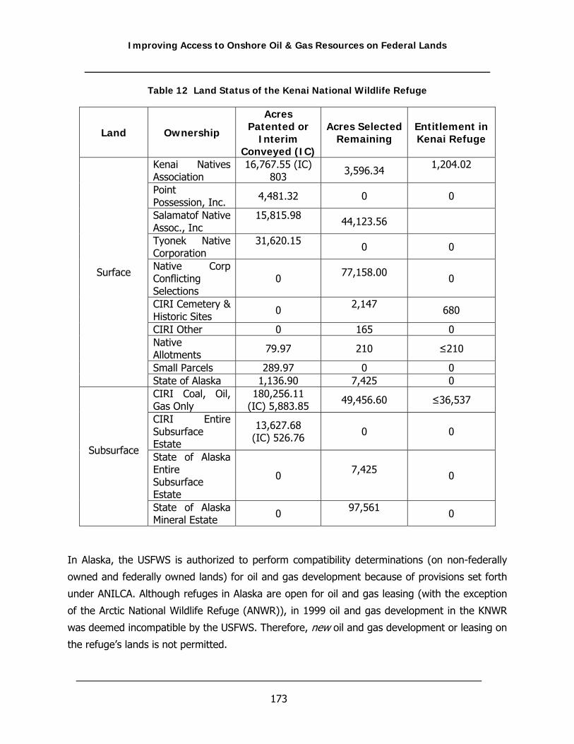
Improving Access to Onshore Oil & Gas Resources on Federal Lands
173
Table 12 Land Status of the Kenai National Wildlife Refuge
Land Ownership
Acres Patented or
Interim Conveyed (IC)
Acres SelectedRemaining
Entitlement in Kenai Refuge
Kenai Natives Association
16,767.55 (IC) 803 3,596.34 1,204.02
Point Possession, Inc. 4,481.32 0 0
Salamatof Native Assoc., Inc
15,815.98 44,123.56
Tyonek Native Corporation
31,620.15 0 0
Native Corp Conflicting Selections
0 77,158.00 0
CIRI Cemetery & Historic Sites 0 2,147
680
CIRI Other 0 165 0 Native Allotments 79.97 210 ≤210
Small Parcels 289.97 0 0
Surface
State of Alaska 1,136.90 7,425 0 CIRI Coal, Oil, Gas Only
180,256.11 (IC) 5,883.85 49,456.60 ≤36,537
CIRI Entire Subsurface Estate
13,627.68 (IC) 526.76 0 0
State of Alaska Entire Subsurface Estate
0 7,425 0
Subsurface
State of Alaska Mineral Estate 0 97,561
0
In Alaska, the USFWS is authorized to perform compatibility determinations (on non-federally
owned and federally owned lands) for oil and gas development because of provisions set forth
under ANILCA. Although refuges in Alaska are open for oil and gas leasing (with the exception
of the Arctic National Wildlife Refuge (ANWR)), in 1999 oil and gas development in the KNWR
was deemed incompatible by the USFWS. Therefore, new oil and gas development or leasing on
the refuge’s lands is not permitted.

Improving Access to Onshore Oil & Gas Resources on Federal Lands
174
A compatible use is defined as “a proposed or existing wildlife-dependent recreational use or
any other use of a national wildlife refuge that, based on sound professional judgment, will not
materially interfere with or detract from the fulfillment of the National Wildlife Refuge System
mission or the purposes of the national wildlife refuge.” Although guidelines for compatibility
determinations do not specifically address oil and gas development, FWS regulations specific to
NWR’s do not allow compatibility provisions for the replacement of lost habitat values or other
compensatory mitigation. Thus, this regulation affectively prohibits new surface disturbance
actions that will impact habitats, an action which is often observed during the construction
phase of development.
Oil and gas development on NWR’s may also be delayed or prohibited thru the compatibility
process because refuge managers typically do not have experience specific to oil and gas and
may not understand the impacts associated with development or how mitigation or best
management practices can be used to minimize impacts. In any case, compatibility
determinations are often implemented when a refuge manager perceives that a proposed action
may be contrary to the purpose of the refuge. A summary of the information that is used by
the refuge manager to perform a compatibility determination is listed below:
• The proposed or existing use;
• The purpose of the refuge;
• The purpose of the NWR;
• Is the use a priority public use?
• Where would the use be conducted?
• Why is the use being proposed?
• The expected impacts of the use on the refuge's and National Wildlife Refuge purposes;
and
• Whether the use is compatible or not compatible.
Unocal Gas Storage Compatibility Determination
The following example describes a recent compatibility determination that was performed as
part of a request by Unocal to expand their storage facilities in the Swanson River field.
Information collected for this description was gathered from publicly available documents.

Improving Access to Onshore Oil & Gas Resources on Federal Lands
175
Until recently, Unocal has been injecting gas into a depleted gas reservoir during the summer
months (when there is an excess in supply) and producing that gas back during the winter
months (when demand exceeds supply). All of the gas placed into storage had physically come
from Sterling, Beluga, and Tyonek gas wells within the Swanson River Field. Gas was produced
from the Swanson River field wells into existing gas gathering facilities, compressed with
existing compressors, and, instead of being sold off-lease, was piped to the gas storage wells.
Unocal estimated that by 2005, additional storage capacity (additional wells/reservoirs) would
be required to handle forecasted seasonal deliverability demand. In order to address this
seasonal demand, Unocal submitted a request to BLM to create additional storage capacity. To
facilitate seasonal deliverability under this new request, it would be necessary to supplement
gas that is physically produced from Swanson River Field and injected into storage with gas that
is physically produced outside of the Swanson River Field. Upon approval, this “outside gas”
would be transported to the Swanson River Field via the existing gas pipeline, compressed with
existing compressors, and piped to existing and newly designated storage wells.
As stated earlier, sub-surface or “down hole” operations within the field are administered by the
BLM under the provisions of the Minerals Leasing Act, whereas, surface use and occupancy are
coordinated with the refuge via the provisions of a lease agreement and through the review and
approval of annual plans of development and operations. Activities within the lease area for
exploration and development of oil and natural gas are legal entitlements held by Unocal and
are not subject to a compatibility review. However, because the new storage capacity was not
designed for production purposes, i.e. gas injection, the USFWS believed gas storage was not a
legal entitlement of the operator within the field’s lease. (It should be noted the Secretary of
the Interior, via Minerals Leasing Act regulations, has the discretion to authorize gas storage,
but is not required to do so.)
Upon a regulatory review by Unocal, it was argued that the USFWS did not have the authority
to require rights-of-way for certain uses outside the scope of oil and gas production, e.g.,
transportation of oil, natural gas, synthetic liquid or gaseous fuels, with the exception, (as
stated earlier), that the authority does not extend to uses associated with oil and gas
production under valid leases such as gathering lines and associated structures used solely in
the production of oil and gas (50 CFR 29.21-9 and 43 CFR 2881.3) (Unocal Memorandum,
2004). From this the question arose, is gas storage a normal or necessary element of oil and
gas development? Although open for interpretation, it was argued that gas storage is a
reasonably and ancillary component that is necessary for oil and gas production.

Improving Access to Onshore Oil & Gas Resources on Federal Lands
176
To further justify this interpretation, under 43 CFR 3101.1-2 the owner of a severed mineral
estate has the right to use so much of the surface estate “as is reasonably necessary to enjoy
the severed mineral estate” (Unocal Memorandum. 2004). That is, the lessee is granted the
exclusive right and privilege to drill for, mine, extract, remove and dispose all the oil and gas
deposits with the right to construct and maintain thereupon, all works, buildings, plants,
waterways, roads, telegraph or telephone lines, pipelines, reservoirs, tanks, pumping stations,
or other necessary structures (Unocal Memorandum, 2004).
After significant debate, in the end the USFWS approved Unocal’s request for construction of
additional storage facilities since their belief was that additional gas storage would not
contribute additional impacts to the refuge over entitled production operations currently
permitted within the area. Although the conclusion was that such normally permitted activities
may have significant long-term impacts on fish and wildlife, their habitats, and the refuge’s
ability to manage for its mandated purposes, such operational actions were considered beyond
the purview of a compatibility review.
The important consideration here was not the regulatory justification of Unocal’s request, or
even the USFWS defense for the need to perform a compatibility determination for such a
request, but that compatibility determinations and the policies which dictate them allow for
interpretation, or in this case, provide unclear guidelines for refuge managers to follow. The
types of determinations that are performed at any given refuge are typically directly related to
the purpose of the refuge. Although the purpose of each refuge, to a certain extent, is
dependent on the critical resources that the refuge was designed to protect or conserve, the
underlying policies which govern each NWR remains the same - that is, to develop a national
program of wildlife and ecological conservation and rehabilitation.
From this it seems reasonable to infer that clarification is needed at the national level to aid in
the identification of compatibility issues common to all NWR’s, or those issues which are likely
to occur, as well as appropriate procedures to mitigate unnecessary resource impacts for
already approved actions. Further more, a better defined oil and gas national policy would
provide refuge mangers with the ability to efficiently evaluate issues which affect them the most
and subsequently, allow for a more informed, consistent decision.
KNWR Comprehensive Plan
Currently, the existing Comprehensive Conservation Plan (CCP) for the Kenai refuge which was
approved in 1985 is being revised per ANILCA requirements and is scheduled for final approval

Improving Access to Onshore Oil & Gas Resources on Federal Lands
177
in 2006. Draft versions of the new CCP were not available during the time of this report, with
the exception of the proposed alternatives and, therefore, subsequent discussion of the KNWR
CCP in this section is based on the 1985 CCP.
A CCP is a congressionally mandated plan which serves as a "master" plan, providing broad
policy guidance and establishment of long-term goals and management objectives for the
USFWS on the refuge. Interestingly, the concept and requirements for a CCP originated in the
KNWR as part of the requirements established under ANILCA. Later, in response to
congressionally acted law, USFWS managed refuges in the continental United States were
required to adopt similar CCP’s for their own use.
In general, a CCP will contain a description of the existing environment on the refuge, a
discussion of management alternatives and impacts, and an assessment of the long-term
effects of implementing these alternatives on refuge resources. Section 304(g) of ANILCA
contains the requirements for comprehensive conservation planning specific to Alaska. One
such requirement dictates the specification of uses within the refuge that are considered
compatible with the major purposes of the refuge. It also specifies that prior to developing a
plan for any refuge, the Secretary of the Interior is required to identify and describe:
• Populations and habitats of fish and wildlife resources of the refuge;
• Define special values of the refuge, as well as any other archeological, cultural,
ecological, geological, historical, paleontological, scenic, or wilderness values of the
refuge;
• Identify areas within the refuge that are suitable for use as administrative sites or visitor
facilities;
• Present potential requirements for access with respect to the refuge; and
• Identify significant problems which may adversely affect the populations and habitats of
fish and wildlife.
Additionally, Section 304(g) of ANILCA gives specific directions to the USFWS to account for and
protect "special values” present in Alaskan refuges, as well as archeological, cultural, ecological,
geological, historical, paleontological, and scenic values. Oil and gas activities are prohibited in
an area considered as a special value. However, none of these values are impacted by the
Swanson River oil and gas activities. According to the existing KNWR CCP, six special values
have been identified:
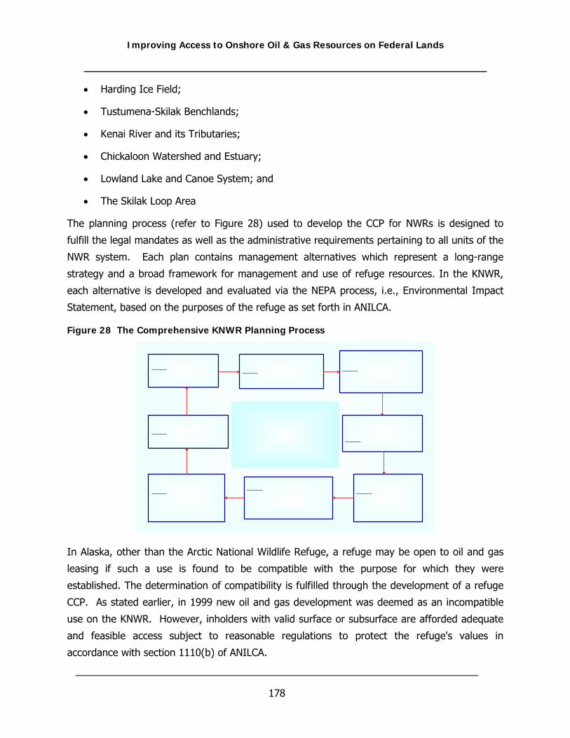
Improving Access to Onshore Oil & Gas Resources on Federal Lands
178
• Harding Ice Field;
• Tustumena-Skilak Benchlands;
• Kenai River and its Tributaries;
• Chickaloon Watershed and Estuary;
• Lowland Lake and Canoe System; and
• The Skilak Loop Area
The planning process (refer to Figure 28) used to develop the CCP for NWRs is designed to
fulfill the legal mandates as well as the administrative requirements pertaining to all units of the
NWR system. Each plan contains management alternatives which represent a long-range
strategy and a broad framework for management and use of refuge resources. In the KNWR,
each alternative is developed and evaluated via the NEPA process, i.e., Environmental Impact
Statement, based on the purposes of the refuge as set forth in ANILCA.
Figure 28 The Comprehensive KNWR Planning Process
In Alaska, other than the Arctic National Wildlife Refuge, a refuge may be open to oil and gas
leasing if such a use is found to be compatible with the purpose for which they were
established. The determination of compatibility is fulfilled through the development of a refuge
CCP. As stated earlier, in 1999 new oil and gas development was deemed as an incompatible
use on the KNWR. However, inholders with valid surface or subsurface are afforded adequate
and feasible access subject to reasonable regulations to protect the refuge's values in
accordance with section 1110(b) of ANILCA.
Improving Access to Onshore Oil & Gas Resources on Federal Lands
179
In addition, to further support oil and gas development in the refuge, the State of Alaska
specifically requested that development of the new CCP “…remain flexible regarding new oil and
gas facilities or modification of existing facilities”. In other words, the USFWS has the
complicated responsibility of balancing the protection of critical resources specific to the KNWR
while approving state supported oil and gas production that in some instances may counter the
purpose of the refuge.
In the existing KNWR CCP, oil and gas development is described as a “significant problem”.
However, specific details to mitigate or manage the effects of oil and gas development are not
provided. Instead, the CCP is limited to a general discussion in regards to the purpose of the
refuge and broad issues which are being propagated by oil and gas related activities. Such
discussion within the CCP is as follows: “Existing laws recognize the need for energy
development as well as wildlife, wilderness, and recreation and resource protection. Refuge
management will be challenged to meet the requirements of sometimes conflicting
management goals. Innovative and costly management actions will be needed to avoid or
minimize adverse impacts of these industrial developments.”
Thus, it is apparent that specific management decisions or processes, as they pertain to oil and
gas, are not contained within the overall “master” management objectives of the refuge, but
rather are handled on a case by case scenario via the compatibility determination process when
appropriate. Furthermore, content requirements contained within the CCP in Alaska are not
driven by USFWS policy in general, but rather are encapsulated in stipulations specified under
ANILCA. The promulgation of ANILCA and the subsequent effects the Act had on refuges in
Alaska (or specifically the KNWR) can be looked upon as a necessity given Alaska’s unique
position in the oil and gas industry. However, one glaring consequence of the ACT again is the
USFWS’s inability to formulate consistent nationwide policy.
In the case of oil and gas development on Alaska refuges, the USFWS has the responsibility to
satisfy ANILCA requirements, as well as there own, while at the same time appeasing state
request to allow for flexible oil and gas management. As a result, this struggle can slow the oil
and gas development process even for those operators who have been afforded certain mineral
privileges under existing lease agreements.

Improving Access to Onshore Oil & Gas Resources on Federal Lands
180
Summary of Federal Agency Oil & Gas Surface Management Policies on Sensitive Lands
Although the BLM is responsible for leasing federally owned oil and gas minerals, as well as
supervising the exploration, development, and production operations of these resources, they
are also responsible for protecting and managing BLM specific sensitive lands, designated by
BLM as Areas of Critical Environmental Concern (ACEC). ACEC’s are locations where special
management attention is required to protect and prevent irreparable damage to important
historic, cultural, or scenic values; fish and wildlife resources; or other natural systems or
processes or to protect life and safety from natural hazards. The ACEC program was conceived
in the 1976 Federal Lands Policy and Management Act (FLPMA), which established the first
conservation mandate for the BLM. The management of sensitive resources, which define an
ACEC, is identified within the framework of a Land Use Plan or regional RMP and the impact
analysis of these resources is evaluated per the NEPA process. Proposed surface disturbance
activities within any given ACEC are only approved when the protection and conservation of
“relevant and important values” can be assured.
BLM national policies and regulations do not prohibit oil and gas development on ACEC lands
nor do they specifically address oil and gas development in ACEC’s. Instead procedures to
address and evaluate development within an ACEC are provided under the general framework
of BLM policy, as well as BLM’s statutory requirements to protect public lands. In any case, the
management of resources within ACEC lands is accomplished through development of regional
RMP’s, which are generated and administered by BLM field offices. BLM field offices are also
required to stringently evaluate potential impacts to ACEC resources through the NEPA process
to assure resource management strategies (protection and conservation) identified in the RMP
can be successfully implemented.
In most cases, approval for oil and gas development on ACEC lands is granted by the BLM,
although difficult, when proposed protective stipulations and mitigation measures can be
utilized to minimize or prevent resource impacts. In situations where impacts to ACEC defining
resources cannot be effectively managed for protection, then development for that particular
area is not permitted. Unlike the USFWS, as discussed above, BLM policies allow for a
moderate level of flexibility that enables the development of oil and gas when the protection of
sensitive federal lands or resources can be demonstrated.

Improving Access to Onshore Oil & Gas Resources on Federal Lands
181
When comparing the regulations of the BLM, the USFWS, the USFS and the NPS and the affects
these regulations have on oil and gas development, it is clear that the USFWS and the NPS
have the most stringent internal energy policies. As discussed in Section 4 of this document,
current NPS policies, as with USFWS policies, prohibit new federal leasing. For these two
agencies, leasing can only be approved when prospective operators can legally demonstrate
that they hold rights to valid mining claims, federal mineral leases, or non-federally owned
minerals. It is important to consider however, that even under these ownership scenarios,
leasing of surface lands for exploration or development proposes is typically impeded or delayed
because of surface use restrictions, stipulations or other relevant policies (refer to Section 4).
The USFS on the other hand is curtailing policy and taking advantage of certain categorical
exclusions established by the Energy Policy Act to encourage development on surface lands
they manage when certain protective conditions can be satisfied (refer to Section 4). Although
the oil and gas policies of the USFS are still limiting, oil and gas development can occur on
lands with restrictive stipulations, as specified under their land management plans, when
impacts to protected resources can be properly evaluated through the NEPA process and
effectively mitigated by use of common and successful industrial practices. This new proactive
approach and realization for the potential of maintaining a legitimate balance with
environmental protection and resource development, as well as establishing energy policy more
consistent with that of BLM’s, may provide a future policy template and catalyst for energy
development on federal lands.

Improving Access to Onshore Oil & Gas Resources on Federal Lands
182
THIS PAGE INTENTIONALLY LEFT BLANK
Improving Access to Onshore Oil & Gas Resources on Federal Lands
183
APPENDIX B
BADGER HILLS COAL BED NATURAL GAS CASE STUDY

Improving Access to Onshore Oil & Gas Resources on Federal Lands
184
THIS PAGE INTENTIONALLY LEFT BLANK

Improving Access to Onshore Oil & Gas Resources on Federal Lands
185
Badger Hills Coal Bed Natural Gas Case Study
Location: Bighorn County, Montana
Watershed: Tongue River Watershed
Operator: Fidelity Exploration & Production Company
The Badger Hills case study presents a comparison of the impacts predicted in both the
Programmatic Final Environmental Impact Statement (FEIS) for Coal bed Natural Gas (CBNG)
development in Montana, and the BLM’s EA for the Fidelity Tongue River-Badger Hills Plan of
Development to actual impacts that have been monitored or observed to various resources. The
impact analyses referenced in this case study were performed to meet National Environmental
Policy Act (NEPA) and Montana Environmental Policy Act (MEPA) requirements for the
regulatory agencies which oversee CBNG development in Montana. Fidelity’s Badger Hills
Project was an expansion of existing CBNG development in Montana (CX Field) which included
5,500 acres of mineral leases of which slightly less than 60 percent were on federally managed
mineral estates. Assessment of the impacts predicted for the Badger Hills EA and MT FEIS
include an evaluation of the assumptions used in each document which are the basis for
development of the impact analysis contained within each document.
There are inherent differences in the assumptions for each document because the MT FEIS was
a programmatic evaluation of CBNG development and the Badger Hills project is site-specific
expansion of an existing CBNG field. These differences related to the data used to perform the
impact analysis and include differences in the expected well life, density of CBNG wells, number
of producing coal seams, rate of water production, and per well surface disturbance. An
evaluation of the estimates of acres from surface disturbing activities which is used as the basis
for the development of impact predictions for several resources including wildlife, soils,
vegetation, and cultural resources, showed a considerable difference based on the assumptions
utilized in each document.
For some of the resources impacts between the two assessments could not be directly
compared without extrapolating the statewide programmatic assessment from the MT FEIS to
the project level of the Badger Hills EA. These included lands and realty impacts, and social and
economic impacts. Furthermore, predicted impacts for these resources could not be compared
to actual or observed impacts because there have been no surveys conducted to identify what
actual impacts may have occurred at this time. Some comparison was facilitated to illustrate
differences in the modeling approaches and the results for the air quality impacts, while for the

Improving Access to Onshore Oil & Gas Resources on Federal Lands
186
social and economic impacts information was extrapolated from outside sources to indicate that
impacts (both positive and negative) have not be realized in the local area.
For some resources monitoring data was available for comparison including limited air quality
data, surface water flow and quality data, and groundwater levels. Surface water impacts
predicted in the MT FEIS and Badger Hills EA to date have not been realized in terms of
increased flow in the Tongue River and decreased water quality (increased EC and SAR).
Surface water monitoring data comparisons from USGS gauging stations along the Tongue
River indicate no observable changes as most data shows comparable flow and quality to
predevelopment conditions. Analysis of predicted water production values from the MT FEIS
and Badger Hills EA when compared to reported groundwater production data from the MBOGC
indicate that the predicted volumes are nearly 7 times greater than the average reported
production from the Badger Hills CBNG wells. Groundwater monitoring data collected by Fidelity
indicates that the predicted radius of drawdown from the Badger Hills EA is not being realized,
with drawdown from the Dietz coals in 2004 extending less than 0.8 miles from the producing
field, approximately 40 percent of the distance predicted in the Badger Hills EA. Actual impacts
to other resources have not been documented in follow-up monitoring reports, but generally,
the smaller acreage of surface disturbance and lower produced water volumes have resulted in
lesser impacts to most of the resources than the NEPA analysis had predicted.
A. INTRODUCTION
The development of impacts for the programmatic MT FEES and the project level Badger Hills
EA are based in part on assumptions used to develop their respective analysis. For the MT FEIS
the assumptions were generated based on the rational of developing a full-field statewide
analysis for CBNG development, while the Badger Hills EA assumptions were based on
information provide to the BLM by Fidelity as defined in the Badger Hills Plan of Development.
In order to facilitate a relative comparison of the impacts predicted from each document some
of the MT FEIS analysis had to be interpreted from the programmatic level in the MT FEIS to
the project level of the Badger Hills EA. The interpretation included assessing per well impacts
when available in the MT FEIS to the number of wells being developed in the Badger Hills POD,
or by assessing the impacts for Big Horn County to the level of development predicted in the
MT FEIS to have occurred by year two. Direct, indirect, and cumulative impacts from the
Badger Hills EA as described for Alternative C are compared to the impacts predicted from the
MT FEIS as described for Alternative E.
B. OBJECTIVE AND PURPOSE

Improving Access to Onshore Oil & Gas Resources on Federal Lands
187
Ultimately, the objective of this case study is to validate the impact calibration methods and
results discovered during the project’s phase I research efforts by applying data from a practical
“real life” scenario to a series of comprehensive calibration and evaluation tools. It is hoped
that the use of a real world check and balance study will sharpen the analysis to better forecast
actual resource impacts and provide field tested feedback to the research team to allow for
identification of additional research needs. By providing a consistent approach to conducting oil
and gas impact analyses under NEPA requirements and by developing a series of “smart”
scenario evaluation tools, agencies and preparers will have an improved understanding of
predicted impacts vs. actual impacts allowing decision makers to have more confidence in their
development choices. Ultimately, this will help expedite the NEPA process, as well as increase
access to Federal lands for oil and gas development.
C. ASSUMPTIONS USED IN DEVELOPING THE COMPARISONS OF IMPACTS
Impact comparisons from the MT FEIS are evaluated for Big Horn County, Montana, and
assume the timing of this project to equate to year two of the MT FEIS analysis timeline from
the impact analysis in the MT FEIS. When available, predicted impacts are drawn directly from
the MT FEIS for Big Horn County; however, these impacts are not always available so
equivalent level of development assumptions have been made to assess comparison of impacts
from the MT FEIS and the Badger Hills EA. The following discussion compares and identifies
the assumptions used in the determination of impacts from the Badger Hills EA to the
assumptions used in the development of impacts for the MT FEIS. Table 13 presents a series of
assumptions that were utilized for the impact analysis for the preferred alternatives for the MT
FEIS and the Badger Hills EA. These assumptions were the basis for the development of level of
impact that could be expected to occur to various resources. Data presented in Table 13 for the
Badger Hills EA assumptions account for a shorter duration than the MT FEIS, and reduced
relative impacts from surface disturbance activities and hydrologic resources.

Improving Access to Onshore Oil & Gas Resources on Federal Lands
188
Table 13 Comparison of Assumptions from MT FEIS and Badger Hills EA
Assumptions presented for both the MT FEIS and Badger Hills EA represent assumptions that were common to all alternatives.
Assumption MT FEIS Badger Hills EA
Well Life 20 years 10-15 years
Well Spacing 1 well per seam/80 acres 1 well per seam/160 acres
No. of Productive Coal Seams Up to 3 seams Up to 5 seams
Surface Disturbance per Well1 3.25 (2.00) 1.68
Initial water production rate 14.661 gpm 14 gpm
Decline in water production Q = 14.661e-0.0242x 20% annual decline
1. Surface disturbance per well represents total construction acreage disturbed for the well and associated roads and facilities, for the MT FEIS construction and reclaimed operation values are presented.
D. SURFACE DISTURBANCE IMPACTS
Surface disturbance impact comparisons are based on calculations from data from the FEIS,
Badger Hills EA and actual values from the project. Table 14 presents a comparison of the
impacts based on the number of CBNG wells present in the Badger Hills Plan of Development.
The data in the Table provides a comparison of pre and post construction disturbance values for
the wells based on ownership. Column 2 from Table 14 presents predicted impacts calculated
to estimate the number of disturbed acres that were expected to result from the Badger Hills
project if develop occurred as described for a typical CBNG project as detailed in the MT FEIS.
Using data from the Badger Hills POD and EA, a total of 177 new CBNG wells would be drilled
and put into production under this project with one previously drilled well being brought into
production for a total of 178 producing CBNG wells (BLM, 2004c). The new CBNG wells for the
project include 92 wells completed on MBOGC managed minerals and includes private (72 wells)
and state (20 wells) minerals, and 85 wells completed on federal minerals. Column 3 presents
the total disturbance area based on data that was provided by Fidelity during the development
of the EA. The values in the Badger Hills Actual column are based on data provided by Fidelity
for the construction disturbance that would result from their proposed developed (Table 14,
column 4). The disturbance values are broken down by mineral ownership because the BLM can
require mitigation measures on federally managed minerals that are not applicable to fee and
state minerals; therefore, the disturbance from the Badger Hills POD federal wells is less than
the fee and state wells. The actual disturbance values in Table 14 are much less than the
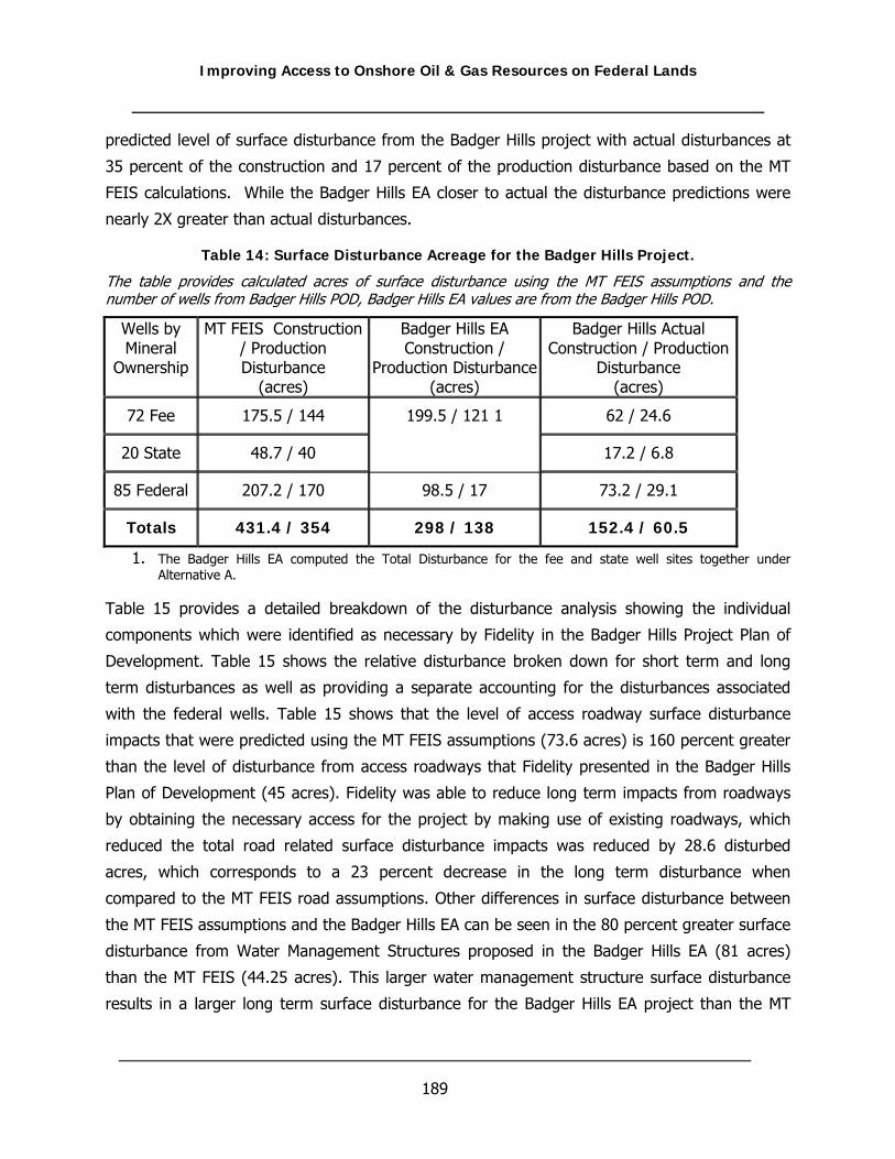
Improving Access to Onshore Oil & Gas Resources on Federal Lands
189
predicted level of surface disturbance from the Badger Hills project with actual disturbances at
35 percent of the construction and 17 percent of the production disturbance based on the MT
FEIS calculations. While the Badger Hills EA closer to actual the disturbance predictions were
nearly 2X greater than actual disturbances.
Table 14: Surface Disturbance Acreage for the Badger Hills Project.
The table provides calculated acres of surface disturbance using the MT FEIS assumptions and the number of wells from Badger Hills POD, Badger Hills EA values are from the Badger Hills POD.
Wells by Mineral
Ownership
MT FEIS Construction / Production Disturbance
(acres)
Badger Hills EA Construction /
Production Disturbance (acres)
Badger Hills Actual Construction / Production
Disturbance (acres)
72 Fee 175.5 / 144 62 / 24.6
20 State 48.7 / 40
199.5 / 121 1
17.2 / 6.8
85 Federal 207.2 / 170 98.5 / 17 73.2 / 29.1
Totals 431.4 / 354 298 / 138 152.4 / 60.5
1. The Badger Hills EA computed the Total Disturbance for the fee and state well sites together under Alternative A.
Table 15 provides a detailed breakdown of the disturbance analysis showing the individual
components which were identified as necessary by Fidelity in the Badger Hills Project Plan of
Development. Table 15 shows the relative disturbance broken down for short term and long
term disturbances as well as providing a separate accounting for the disturbances associated
with the federal wells. Table 15 shows that the level of access roadway surface disturbance
impacts that were predicted using the MT FEIS assumptions (73.6 acres) is 160 percent greater
than the level of disturbance from access roadways that Fidelity presented in the Badger Hills
Plan of Development (45 acres). Fidelity was able to reduce long term impacts from roadways
by obtaining the necessary access for the project by making use of existing roadways, which
reduced the total road related surface disturbance impacts was reduced by 28.6 disturbed
acres, which corresponds to a 23 percent decrease in the long term disturbance when
compared to the MT FEIS road assumptions. Other differences in surface disturbance between
the MT FEIS assumptions and the Badger Hills EA can be seen in the 80 percent greater surface
disturbance from Water Management Structures proposed in the Badger Hills EA (81 acres)
than the MT FEIS (44.25 acres). This larger water management structure surface disturbance
results in a larger long term surface disturbance for the Badger Hills EA project than the MT
Improving Access to Onshore Oil & Gas Resources on Federal Lands
190
FEIS assumptions predicted. The need for the larger area for water management structures can
be accounted for in a difference in water management practices described in the MT FEIS and
Fidelity’s proposed plan. The MT FEIS predicted the use of infiltration impoundments which
allow for greater volumes of water to be managed with lesser surface disturbance than the
Fidelity’s planned containment ponds which do not allow infiltration of produced water. Table 15
shows that the short term surface disturbances from the Badger Hills EA range from 33 to 90
percent of the surface disturbance impacts predicted by the MT FEIS assumptions for a
development the size of the Badger Hills Project. Fidelity was able to reduce the short term
surface disturbances by combining water, gas and electric utilities within a common disturbance
associated with existing and newly constructed roads, and by developing more than three coal
seams from a combined well site.

Improving Access to Onshore Oil & Gas Resources on Federal Lands
191
Table 15: Level of Surface Disturbance Comparison
This table presents a breakdown of the components which make up the total surface disturbance values for a CBNG project and assumes the 178 well level of development for the Badger Hills Project.
CBNG Facility
MT FEIS Assumptions
Common to All Alternatives
(acres)
Badger Hills EA Fee and State
Wells (acres)
Badger Hills EA Federal Wells
(acres)
Long Term Disturbance
Roads All Weather (graveled) 20.5 10 3
2-Track 53.1 20 12 1 73.6 30 15
Compressor Sites Field Compressors 3.6 6 2 Sales Compressor 0.89 4 0
2 4.49 10 2 Water Management
Impoundments 44.5 80 --- Discharge Points 0.36 1 ---
3 44.9 81 0 Total Long Term (1+2+3) 123 121 17 Short Term Disturbance Well Sites
State Well Sites 5 4 Private Well Sites 18 18 Federal Well Sites 21.25 0 18
4 44.25 22 18 Flowlines
Gas/Water Flowlines (from wells) 160.2 29.5 50.5
Produced Water Flowlines (to river) 6 6
5 166.2 35.5 50.5 Powerlines
Aerial 35.6 6.5 3 Buried 62.3 14.5 10
6 97.9 21 13 Total Short Term
(4+5+6) 308.4 79 61.5
TOTAL (1+2+3+4+5+6) 431.4 199.5 98.5 Total for the Badger Hills EA 298

Improving Access to Onshore Oil & Gas Resources on Federal Lands
192
E. AIR QUALITY
Air Quality Impact predictions for each document are based on modeling efforts which
evaluated the direct and indirect impacts from CBNG development and cumulative impacts from
activities across the eastern Montana.
DIRECT AND INDIRECT IMPACTS TO AIR QUALITY
The Badger Hills EA analyzed expected air impacts from the Project by drawing upon two
separate dispersion modeling analyses and reports. The first was a project-specific analysis
performed by the BLM using the Industrial Source Complex Short Term model which included
one pollutant, NO2, and the development level described in Alternative B. A single instance of a
monitored exceedance of the 24-hour particulate matter (PM10) National Ambient Air Quality
Standard (NAAQS) from 2003 for pollutants expected to be emitted was reported as a result of
the Project. The Badger Hills EA project specific modeling analysis for NO2 shows a localized
200 percent greater increase in annual NO2 compared to the modeling data from the MT FEIS.
However, a comparison of the monitoring data found no significant ambient air impacts have
been detected to date and the predicted site-specific levels would be below the state and
federal ambient air quality standards. The MT FEIS air quality model predicted impacts that
would result in exceedances on a regional scale. These impacts included: modeled exceedance
of the 24-hour PM10 NAAQS, possible visibility degradation in certain Class I areas and one case
of concern over acid deposition. In general, the modeled analyses presented for the MT FEIS
and the Badger Hills EA represent the greatest expected air impacts for full field development of
CBNG (MT FEIS) and the Badger Hills Project, respectively.
ACTUAL IMPACTS TO AIR QUALITY
Since CBNG activities from the CX field and Wyoming CBNG projects has been ongoing for
several years, one effective means of understanding whether this activity is making an impact
on the ambient air quality conditions in the Project area is to consider recent monitored data.
Since the significant air impacts from the dispersion modeling results included short-term (24hr)
PM10, visibility, and acid deposition impacts, these were assumed to be potential concerns and
monitoring data was researched. From the EPA’s National Atmospheric Deposition Program
website, pH trend data (see Figure 29) from the monitor located at the Little Bighorn Battlefield
National Monument (MT00) was charted. Figure 29 shows that pH levels of rainwater collected
between 1985 and 2004, the pH has varied between 5 and 5.5 over the 20 year period of
record. This monitored EPA data from near the Project area indicates that to date there does

Improving Access to Onshore Oil & Gas Resources on Federal Lands
193
not appear to be a change in the acidic deposition from CBNG Project emissions.
Figure 29: EPA Monitored Annual Laboratory Rainfall pH Data
Rainfall pH data from the EPA’s monitoring station at the Little BigHorn Battlefield National Monument Station MT00 (1984-2004)
Finally, the EPA collects criteria pollutant data from across the nation and makes those data
available on their Airdate web page by State and County. Table 16 summarizes a portion of
those data for three counties in or near the Project area. Table 16 shows that for the Big Horn,
Rosebud, and Yellowstone Counties of Montana all monitored PM10 concentrations are well
below NAAQS and MAAQS levels (50 µg/m3 for the annual and 150 µg/m3 for the 24-hr
standard). In fact, the monitored concentrations are generally half of the ambient standards.
Rosebud County’s data tends to run higher than the data recorded in the other two counties,
but it remains well below standards. A review of Table 16 shows that the modeled cumulative
24-hr PM10 concentrations were 107 µg/m3 and when a conservative background value of 105
µg/m3 is added to that, the result is 212 µg/m3. This predicted value is higher than any recorded
concentration for any of the county monitoring sites.

Improving Access to Onshore Oil & Gas Resources on Federal Lands
194
Table 16: Summary and Comparison of Cumulative Air Quality Impacts
Table of cumulative air quality impact data from MT FEIS and Badger Hills EA compared to actual monitored air quality values and the state and federal ambient air quality standards.
Air Quality Pollutants and
Averaging Periods
MT FEIS (μg/m3)
Badger Hills EA (μg/m3)
Actual/Monitored Impacts (μg/m3)
NAAQS/ MAAQS (μg/m3)
Annual NO2 11 (2212) 23.9 (29.911) 61; 118 94
(H2H) One hour NO2 207 (32412) 263.5 (338.511) 751; 1178 564
(H2H) 8 hour CO 337 (693712) Not modeled 66008 10000
(H2H) 1 hour CO 548 (1554812) Not modeled 150008 26450
Annual SO2 1 (1712) Not modeled 0.52; 168 52
(H2H) 24 hour SO2 11 (8412) Not modeled 82; 738 262
(H2H) 3 hour SO2 24 (31512) Not modeled 302; 2918 1300
(H2H) 1 hour SO2 28 (69412) Not modeled 6668 1300
Annual PM10 14 (4412) Not modeled 14 and 293; 308 50
24 hour PM10 107 (21212) Not modeled 41 and 1703; 1058 150
Visibility Impairment –
Class I6
13 days @
Yellowstone NP
Not modeled 7.3 dV; SVR 182 km
(119 mi)4
Visibility Impairment –
Class II6
92 days @ NCIR &
116 days @ CIR
Not modeled
Atmospheric Deposition7 1.8 ueq/L Not modeled 5.24 ph5; 5.8 ueq/L13
1 – Monitored values from the MDEQ and used in the Badger Hills EA. 2 – Monitored values on the NCIR from data in the Roundup Power Project 2002. 3 – Monitored values from two tribal monitors in 2003 (includes one violation measured at Lame Deer). 4 – Monitored values from 2001 average readings at Yellowstone NP. 5 – Monitored value from Little Bighorn NM in 2002. 6 – There are no applicable local, state, tribal, or federal visibility standards. The analysis assumed that a 1.0 dV change
would be a reasonably foreseeable significant adverse impact. Thus, the # of days > 1 dV are shown. 7 – There are no applicable local, state, tribal, or federal acid deposition standards. The analysis assumed that a “limit of
acceptable change” is a 10 percent (1 ueq/L) change in the acid neutralizing capacity (ANC) for lakes with a background ANC > 25 ueq/L. The only lake meeting these criteria in the modeling domain is the Upper Frozen Lake in the Bridger WA.
8 – Montana background concentrations used in the Argonne analysis. 9 – Predicted value is a 3.3 percent change of the ANC for the Upper Frozen Lake. 10 – Predicted value in Yellowstone NP. 11 – Total modeled concentration = modeled concentration + background concentration (see note 1). 12 - Total modeled concentration = modeled concentration + background concentration (see note 8). 13 – Monitored value of ANC is based upon only 6 samples between 1997 and 2002.

Improving Access to Onshore Oil & Gas Resources on Federal Lands
195
Table 17: EPA Air Quality Report of Criteria Pollutant Data for 3 Counties in Montana.
Data represents EPA’s air quality monitoring results for three counties near the Badger Hills Project.
YEAR CO
(ppm) NO2 (ppm)
O3 (ppm)
SO2 (ppm)
PM2.5 (μg/m3)
PM10 (μg/m3)
MONTANA COUNTY
2nd Max 1-hr
2nd Max 8-hr
Annual Mean
2nd Max 1-hr
4th Max 8-hr
2nd Max 24-hr
Annual Mean
98th Percentile
Annual Mean
2nd Max 24-hr
Annual Mean
2005 42 24 Big Horn Co
2005 38 15.6 80 27 Rosebud Co
2005 4.4 2.3 0.003
0.07
0.058
0.018 0.004 22 7.4 59 17
Yellowstone Co
2004 82 25 Big Horn Co
2004 0.003 0.00
4 0.001 17 5.9 48 22 Rosebud Co
2004 6.8 3.7
0.044 0.006 19 8.2 38 21
Yellowstone Co
2003 0.00
1 0.001 43 11 Big Horn Co
2003 0.003 0.00
9 0.003 19 7.1 169 28 Rosebud Co
2003 7.5 4.4
0.032 0.006 22 8 45 17
Yellowstone Co
2002 0.00
2 0.001 67 19 Big Horn Co
2002 0.004 0.01
4 0.003 25 6.2 137 28 Rosebud Co
2002 8.5 4.3
0.052 0.007 14 6.6 26 14
Yellowstone Co
2001 Big Horn Co
2001 0.003 0.02
7 0.003 14 8.5 135 35 Rosebud Co
2001 8.6 5.2
0.037 0.007 23 7.6 32 16
Yellowstone Co
In general, this historical comparison (Table 17) illustrates that the significant air impacts that
were modeled in support of either the Badger Hills EA or the MT FEIS have not been observed
in monitored data. The predicted significant air impacts from the cumulative source group
models have not appeared in recent monitoring data. The Badger Hills Project as it currently
exists does not appear to be contributing the air quality impacts in and around the PRB that
modeling efforts from the MT FEIS and Badger Hills EA predicted.

Improving Access to Onshore Oil & Gas Resources on Federal Lands
196
F. CULTURAL RESOURCES
Cultural resources include sites, remains, or structures that are of value to a community of
people or that are of historic importance. A comparison of impacts to paleontological resources,
which encompasses fossils and other records of past life, is also included in this discussion.
DIRECT AND INDIRECT IMPACTS TO CULTURAL RESOURCES
According to the Badger Hills EA, no cultural resources on federally owned surfaces would be
affected by the CBNG wells and associated facilities because of BLM required mitigation
measures. On private surface portion of the Badger Hills project, two eligible sites may be
affected by a proposed private well and an infrastructure corridor (Melton, 2004).
The MT FEIS predicted that 629 cultural sites would be identified for the preferred alternative
(BLM, 2003b). Big Horn County is estimated to contain about 80 of these sites assuming that
Big Horn County comprises 12.6 percent of the acreage for the MT FEIS planning area, and
about nine sites would be identified within the first two years based on the MT FEIS assumption
that 11 percent of the total CBNG development would be completed at this point in time. The
number of sites in the project area that would be eligible for the National Register of Historic
Places is predicted to be between 119 and 170 or between 15 and 22 in Big Horn County using
the same assumption of proportionality.
Another method of assessing the anticipated impacts to cultural resources from the MT FEIS is
to use the assumption that there would be one cultural site for every 100 acres surveyed for
cultural resources (BLM 2003b). Based on this assumption and the prediction that each of the
6,300 total producing wells in Big Horn County would disturb 3.25 acres per well for a total of
20,475 acres, about 205 sites would be expected to be encountered. Within the first two years
of development, 23 sites would be expected to be found based on the MT FEIS prediction that
CBNG development would be at 11 percent completion. However, development has not
progressed as quickly as predicted, so fewer sites would most likely be encountered. If one
assumes the total acreage disturbed from the Badger Hills EA (298 acres) is applied to the
cultural resource density defined by the FEIS, three cultural resource sites would be predicted
to be impacted by the Badger Hills project.
The MT FEIS stated that impacts to paleontological resources would occur if these resources
were encountered unexpectedly, while the Badger Hills Project Area is not expected to have
significant paleontological resources (BLM, 2003b) (Melton, 2004).

Improving Access to Onshore Oil & Gas Resources on Federal Lands
197
CUMULATIVE IMPACTS TO CULTURAL RESOURCES
When estimating cumulative impacts to cultural resources, the Badger Hills EA provided
predictions from the MT FEIS that an estimated 5,135 cultural sites could be identified with
between 517 and 735 sites eligible for listing on the National Register of Historic Places (Melton,
2004). This would equate to 647 sites in Big Horn County with between 65 and 93 eligible for
listing.
The Badger Hills EA also accounted for nearby development in its cumulative analysis, including
Yates Petroleum’s proposed 14 exploratory wells northwest of the Plan of Development, the Dry
Creek project, the Coal Creek Plan of Development, and the Spring Creek and Decker Mines
(BLM, 2004c).
The Badger Hills EA states that the proposed project would not impact any large or conspicuous
paleontological remains on Federal surface or minerals (BLM, 2004c). The MT FEIS also
assessed cumulative impacts to paleontological resources, predicting an increase in vandalism
or fossil removal with greater CBNG Development and increased access to remote areas (BLM,
2003b).
ACTUAL IMPACTS TO CULTURAL RESOURCES
Previous inventories conducted in the coal mine and Tongue River Dam has identified 17
cultural resource sites. To date, two of these sites have been determined to be eligible for the
National Register of Historic Places, three have been determined not eligible for listing, and
status has not been determined for the remaining 12 sites (Melton, 2004). Class III cultural
resource inventories for all of the Federal wells and associated infrastructure developments
completed between December 2002 and August 2003 found no cultural sites and one isolated
find location (Melton, 2004). In addition, no sites were found when an infrastructure corridor
was inventoried. The State of Montana prepared a cultural resource inventory that addressed
portions of the project in which no cultural resources were found (Melton, 2004). Actual impacts
to cultural resources based on the surveys conducted for CBNG development in the project area
compare well to predicted impacts based on the recent inventories (Melton, 2004). However,
due to the fact that mitigation measures are being implemented on federal mineral
development areas it is likely that fewer cultural or paleontological sites will be loss than
predicted.

Improving Access to Onshore Oil & Gas Resources on Federal Lands
198
G. LANDS AND REALTY
Both the Badger Hills area and the MT FEIS planning area have mixed ownership of surface and
mineral estate between the federal government, the State of Montana, and private individuals
or companies.
DIRECT AND INDIRECT IMPACTS TO LANDS AND REALTY
The Badger Hills EA did not predict many impacts to Lands and Realty from proposed CBNG
development. No gains or losses in acreage due to change in ownership of federal, state, or
private surface/minerals were predicted to occur. However, it was noted that land within
federal, state, or private categories may pass between owners (BLM, 2004c). The county road
which necessitates this right-of-way would be more heavily traveled by vehicles and could
deteriorate faster than if CBNG development was not present in the area (BLM, 2004c).
The MT FEIS detailed more potential impacts from CBNG development than the Badger Hills EA;
these included such things as increased fire hazard, increased motorized access to the area,
generation of dust, increased noise levels, physical intrusion by CBNG crews and equipment,
and displacement of land uses from roads and utility lines. The MT FEIS also predicted that
cropland could be affected during the construction phase of CBNG development due to changes
in irrigation patterns and the introduction of noxious weeds. Forest land was also expected to
sustain impacts due to commercial harvest of trees in the right-of-way and a decrease in timber
growth during production due to the right-of-way, well pads, and roads. Lastly, impacts that
may result from construction related surface disturbances include noxious weed introduction,
increases in insect populations from slash buildup, and increased access for forest and fire
management.
CUMULATIVE IMPACTS TO LANDS AND REALTY
According to the Badger Hills EA, there were no cumulative impacts that were predicted to
affect land and/or mineral ownership in the Badger Hills project area (BLM, 2004c). The MT
FEIS, however, did predict some cumulative impacts relating to land use, including loss of
cropland, as well as decreased property value, decreased opportunity for community
development, and increased average daily traffic.

Improving Access to Onshore Oil & Gas Resources on Federal Lands
199
ACTUAL IMPACTS TO LANDS AND REALTY
Actual impacts to lands and realty have not been compared to predicted impacts because no
recent surveys have been made and no new data was made available since development began
in the area. It is assumed that current actual impacts are less than those predicted in the MT
FEIS because development has not occurred at the rate that had been expected.
H. SOCIAL AND ECONOMIC CONDITIONS
Social and Economic Conditions analysis encompasses employment, personal income,
demographics, social organization, and government revenues and taxes in a project area. Big
Horn County includes parts of the Crow Reservation and Northern Cheyenne Reservation and
has a population base that is comprised of 59.7 percent Native Americans. Unemployment was
high in the county when it was assessed at 14.4 percent in the year 2000 and represented the
highest level for any county in Montana (BLM, 2003b). Due to the large Native American
population and number of individuals considered low-income in Big Horn County, environmental
justice issues are of concern.
DIRECT AND INDIRECT IMPACTS TO SOCIAL AND ECONOMIC CONDITIONS
Employment
There is a large difference between the Badger Hills EA and the MT FEIS employment
predictions. The Badger Hills EA predicted that there would be little impacts to employment
beyond the temporary jobs created by development, drilling, and production. The MT FEIS
predicted total jobs created for the project life of CBNG development to be 17,013 (BLM,
2003b). Utilizing the assumption that Big Horn County will account for 38.3 percent of total
CBNG development in Montana, 6,516 jobs could be predicted to be created over the first 20
years of CBNG development in Big Horn County. It was predicted that by this point in time (it is
currently year 2 since the completion of the MT FEIS) there would be 766 new CBNG wells, 295
jobs created, and approximately $9 million in wages earned in Big Horn County based on the
above assumption. During the abandonment phase (years 21-40), an estimated additional 404
jobs would have been created in the County (BLM, 2003b). These numbers were predicted to
potentially be about 10 percent higher based on water management practices that would
require extra jobs. (BLM, 2003b). The MT FEIS also predicted the need to bring in people from
outside areas to develop CBNG.

Improving Access to Onshore Oil & Gas Resources on Federal Lands
200
Personal Income
The Badger Hills EA states that CBNG development under Alternative C could potentially
increase personal income in the project area (BLM 2004c). The MT FEIS predicted for its
preferred alternative that over the first 20 years, wages paid for all phases of the project would
total approximately $598 million (BLM, 2003b). Calculated wages paid to residents of Big Horn
County would be about $229 million based on Big Horn County containing 38.3 percent of
projected development.
Demographics
Population demographics were not specifically analyzed in the Badger Hills EA. The MT FEIS
differed from the Badger Hills EA as its preferred alternative required workers from outside the
area to relocate to the area, with the greatest potential for new population in Big Horn, Powder
River, and Rosebud counties (BLM, 2003b).
Government Revenues and Taxes
Although not quantified, the Badger Hills EA predicted annual increases in government
revenues, including property, production, and income taxes and state and federal production
royalties (BLM, 2004c). The MT FEIS similarly predicted increases in government revenues and
taxes. Using the assumption stated in the MT FEIS that each producing well generates about
$182,500 in gross production income per year of operation, it is estimated that 663 producing
wells in Big Horn County would result in $121 million in gross production income in Big Horn
County within the first two years. CBNG production would also provide revenue from natural
resource taxes and sales of goods and services to oil and gas employees (BLM, 2003b).
Environmental Justice
No adverse impacts would be expected to disproportionably affect minority or low-income
populations for either the Badger Hills EA or the MT FEIS.
CUMULATIVE IMPACTS TO SOCIAL AND ECONOMIC CONDITIONS
The Badger Hills EA predicted that some of the jobs and taxes and royalties gained from CBNG
development could replace coal mining jobs and taxes and royalty lost due to coal production
declines (BLM, 2004c). The Badger Hills EA did not predict cumulative impacts concerning
environmental justice issues. The MT FEIS predicted that CBNG would not have a very large
socioeconomic effect except for those discussed in Big Horn, Powder River, and Rosebud
counties. Additional wells that may be developed on the Northern Cheyenne Reservation, the

Improving Access to Onshore Oil & Gas Resources on Federal Lands
201
Crow Reservation, and Forest Service Lands and the expansion of coal mining in the area could
have social and economic impacts as well (BLM, 2003b).
ACTUAL IMPACTS TO SOCIAL AND ECONOMIC CONDITIONS
Actual impacts to social and economic conditions cannot be compared to predicted impacts for
social and economic conditions because no recent studies have been prepared since
development has begun in the area. However, comparisons between neighboring counties in
Wyoming can provide come insight into what the actual impacts are to the lack of development
in Big Horn County. Government revenues and taxes from CBNG development can make a
substantial difference to a local economy. For example, Campbell County in Wyoming has
adopted a budget of over $88 million in 2005, compared to a $4 million budget for the same
year in Powder River County in Montana, which it borders (RMER Staff, 2005). This difference in
budgets is due to the fact that Campbell County has had over 10 years of CBNG production
whereas Powder River County only has limited production.
I. SOILS
Analysis of impacts to soils encompasses soil erosion, contamination, compaction, surface
disturbance, and impacts to soil chemistry. Impacts to soils are generally equivalent to the
amount of surface disturbance.
DIRECT AND INDIRECT IMPACTS TO SOILS
Productivity
The predicted acreage that could be disturbed by Land Application Disposal in the Badger Hills
area of emphasis is 152 acres (BLM, 2004c). Land Application Disposal has the potential to
impact soil productivity. Data from the Badger Hills EA indicates that during times of irrigation,
productivity can increase and post-irrigation, soil productivity could decrease. Impacts to soil
productivity on roads were accounted for in the Badger Hills EA. Productivity on two-track roads
could decrease 700 lbs/acre while productivity on improved roads would be markedly less, with
a decline of 1400 lbs/acre. There would be no capability of productivity on improved all-season
roads, 100 lbs/acre on two track roads, and 0 lbs. /acre on improved roads (BLM, 2004c).
The MT FEIS suggests that produced water would be managed per a site-specific water
management plan which would reduce the impacts to soil productivity caused by the application
of water having high- Sodium Absorption Ratio (SAR) to soils. Under these conditions, the
impacts to productivity would be less than predicted in the MT FEIS. The discharge of produced

Improving Access to Onshore Oil & Gas Resources on Federal Lands
202
water, as opposed to the use of impoundments, allows for fewer disturbances at the surface,
directly impacting soil productivity locally, but does not account for potential downstream soil
productivity impacts.
Surface Disturbance
The Badger Hills EA suggests that 298 acres have the potential to experience surface
disturbance (BLM, 2004c). All 85 of the federal wells and the 92 fee and state wells have been
located at sites which can be drilled without a well pad. As such, minor surface disturbance
would occur with the drilling of these wells (BLM, 2004c). In the Badger Hills area of emphasis,
approximately 4.4 miles of improved roads would be constructed to provide access to facilities
and infrastructure. Approximately 10 miles of new and 12 miles of existing 2-track trails would
be used to access well sites.
Predictions in the MT FEIS suggest that a total of 55,400 acres would be disturbed from CBNG
development (BLM, 2003b). Big Horn County encompasses 12.6 percent of the total acreage
analyzed in the MT FEIS (BLM, 2003b). Assuming the total surface disturbance is 6,980 acres,
768 acres would be disturbed after two years. However, if acreage impacts calculated based on
the percent of CBNG development that is expected to occur in the county then impacts to
grasslands in Big Horn County then the total surface disturbance is 21,218 acres, 2,334 acres
would be predicted to have been disturbed by year two. The acreage of surface disturbance per
well, as stated in the MT FEIS, is 1.0 acres for exploration, 3.25 acres for construction, and 2.0
acres for operations (BLM, 2003b). The Badger Hills project proposes a total of 178 wells. This
would equate to a total surface disturbance of 178 acres for exploration, 578 acres for
construction, and 356 acres for operations.
Another consideration when discussing surface disturbance is roads. The Badger Hills EA
predicts that 3 acres of disturbance will occur from all weather roads and 12 acres of
disturbance will occur from two-track roads, totaling 15 acres. However, the MT FEIS proposes
that 20.5 acres of soil would be disturbed by all weather roads, 53.1 acres would be disturbed
by two-track roads, for a total of 73.6 acres of impacts to soils. Clearly, the MT FEIS CBNG
development scenario provides a scenario in which surface disturbance predictions are greater
than the disturbance predicted in the Badger Hills area by a factor of almost 400 percent.
CUMULATIVE IMPACTS TO SOILS
Although most of the direct effects to soils would end once production facilities were removed
and rehabilitated, some impacts could still be sustained in managed irrigation areas. After
Improving Access to Onshore Oil & Gas Resources on Federal Lands
203
managed irrigation has ceased, future soil failure and loss of vegetation or surface soil
stabilization can occur due to changes in salinity and soil chemistry from precipitation. Under
the preferred alternative of the MT FEIS, disturbances from CBNG development, conventional oil
& gas development, coal mining, among other projects occurring in the region over the next 20
years would result in the disturbance of about 50,700 acres of soil in Big Horn County (BLM,
2003b). If only the production phase of CBNG, conventional oil & gas development, and coal
mining projects occurring in the region are considered, the amount of disturbance would be
reduced to 30,500 (BLM, 2003b). There would be minimal unavoidable and irreversible impacts
to soils. There would be a temporary increase in soil erosion, runoff, and sedimentation, mostly
during construction activities (BLM, 2003b). Development of the Crow and Northern Cheyenne
reservations would disturb between 7,200 acres and 12,100 acres per reservation (BLM,
2003b).
The MT FEIS predictions are greater than what was predicted in the Badger Hills EA because
the level of development predicted is far greater than that for the Badger Hills EA. The rate of
development predicted in the MT FEIS is not being met and analysis of the surface disturbance
impacts from the Badger Hills EA indicate that even on a field scale, the impacts predicted in
the MT FEIS are not occurring.
ACTUAL IMPACTS TO SOILS
Development of CBNG and other activities within the Badger Hills project area surface impacts
are noted to be less than the MT FEIS predictions. Actual development impacts may vary
slightly from what the Badger Hills EA predicted, but for the most part, disturbed acres related
to well pads, roadways, and other infrastructure should be near the levels indicated in the
Badger Hills EA (BLM, 2004c).
J. WATER RESOURCES
Predicted water related impacts discussed under the Preferred Alternative (Alternative C) in the
Badger Hills EA were compared to predicted impacts as detailed under the Preferred Alternative
(Alternative E) in the MT FEIS (BLM, 2003b and BLM, 2004c). In addition, there are several
sources of monitored data which can be used to evaluate actual conditions for both surface
water and groundwater, including US Geological Survey (USGS) surface water gauging stations,
Montana Bureau of Mines and Geology (MBMG) monitoring wells, and Fidelity’s own monitoring
system.

Improving Access to Onshore Oil & Gas Resources on Federal Lands
204
DIRECT AND INDIRECT IMPACTS TO SURFACE WATER
Direct impacts to surface water are predicted in the Badger Hills EA as a result of Fidelity
utilizing their existing discharge permit to discharge produced water into the Tongue River;
none of the other water management practices proposed for the Badger Hills project are
expected to have direct impacts to surface water. Similarly, the MT FEIS and accompanying
Surface Water Quality Technical Report assessed the quality of surface water that would result
from discharges associated with CBNG production. Mixing models for both document predicted
approximate similar values for the flow, and EC at two of the three gauging stations (data was
not calculated for the Dam station for the MT FEIS). While SAR impacts are shown to be more
conservative for the 7Q10 values (5.34 and 6.79) calculated for the MT FEIS than the values
calculated in the Badger Hills EA (2.37 and 1.90). Indirect impacts to surface water were
predicted to have a low chance of occurring in the Badger Hills EA because of monitoring
requirements for the proposed off-channel impoundments and the land application disposal
area. Since both of these systems would be monitored to ensure they function as designed, i.e.
impoundments are lined and irrigation application rates are monitored, the Badger Hills EA
predicts the likelihood of these water management practices to be low. The MT FEIS considered
indirect impacts surface water to be greater because the impoundments would be unlined and
designed for infiltration. Unlined infiltration impoundments have the potential for water to seep
downward to a confining zone and then migrate laterally to surface waters.
CUMULATIVE IMPACTS TO SURFACE WATER
The cumulative impact discussion from the Badger Hills EA includes additional discharges of
treated CBNG produced water into the Tongue River from another CBNG development project.
This treated water has lower EC and SAR concentrations than the water that is currently within
the river and thus is predicted to result in an increased flow but with decreased EC and SAR at
both the Tongue River Dam and Birney Day School stations.
ACTUAL IMPACTS TO SURFACE WATER
In order to attempt quantification of observed impacts, data from each of the gauging stations
was acquired post CBNG development at a discharge approximating the evaluated flow rate. In
comparing the data from the predicted models to monitored data from the USGS gauging
stations located at these modeled points, the monitoring data indicates that at the time the
samples were collected from the gauging stations the anticipated impacts were not discernible
from pre-development existing conditions.

Improving Access to Onshore Oil & Gas Resources on Federal Lands
205
DIRECT AND INDIRECT IMPACTS TO GROUNDWATER
The direct groundwater impacts predicted in both the MT FEIS and the Badger Hills EA are a
result of extraction of coal seam groundwater associated with the production of CBNG. There
are some basic assumptions that differ between the MT FEIS and Badger Hills EA related to
density of the wells and the rate of water production. Figure 30 shows that the assessment
approach used in the Badger Hills EA and the MT FEIS has predicted a higher initial production
rate than what is currently being reported for these wells. There may be extraneous factors that
are resulting in the rate of production being less than what the wells are capable of producing
such as ongoing testing, water management limitations or the current regulatory and legal
environment of CBNG development in Montana.
The other direct impacts associated with CBNG development assessed in both the Badger Hills
EA and MT FEIS is the extent of the drawdown within a coal seam aquifer as a result of
production, which for comparison purposes will be determined by the 20 foot drawdown
contour within the producing coal seam aquifers. A groundwater model was developed for the
MT FEIS by the MBMG, which evaluated the extent of drawdown which would result from 1,082
CBNG wells producing from three coal seams in a single field (Wheaton and Metesh, 2002). This
model predicted the extent of the 20 foot drawdown area to extent up to 5 miles from the edge
of a producing field. The Badger Hills EA used a simpler approach to assess the extent of
drawdown using a Theis equation and regional aquifer characteristics to assess the extent of
drawdown from the proposed Badger Hills production by treating all the producing wells from
each coal seam as if they were a single well.

Improving Access to Onshore Oil & Gas Resources on Federal Lands
206
Figure 30 Comparison of the Water Produced in Association with CBNG
Predicted CBNG produced water volumes from MT FEIS and Badger Hills EA plotted against actual production reported to the MBOGC.
CUMULATIVE IMPACTS TO GROUNDWATER
Cumulative impacts assessed for groundwater in the Badger Hills EA and MT FEIS include
development of other CBNG projects in Montana and Wyoming, and the impacts of the coal
mines located near this development project. The Badger Hills EA estimates a cumulative
impact to groundwater drawdown to be up to 3.6 miles from the producing field, while the MT
FEIS model predicted up to 5 miles of drawdown from a CBNG field (BLM, 2004c and Wheaton
and Metesh, 2002).
ACTUAL IMPACTS TO GROUNDWATER
For comparison purposes, data from Fidelity’s annual groundwater modeling reports was
compared to the drawdowns predicted in the Badger Hills EA (Fidelity, 2000 and Fidelity, 2005).
The monitoring data suggests that the predicted impacts from the Badger Hills EA have over-
predicted the first year and the 5 yr radius of drawdown near the CX Field. The Fidelity
monitoring data indicates that groundwater drawdown has not extended outward to the extent
that the Badger Hills EA had predicted, nor to the extent that MBMG has indicated.

Improving Access to Onshore Oil & Gas Resources on Federal Lands
207
K. VEGETATION
Impact prediction for vegetation resources involves a comprehensive discussion of the potential
introduction of invasive species, potential changes to species compositional characteristics, and
the relative amount of acreage that can potentially be impacted from construction and surface
disturbing activities related to CBNG production.
DIRECT AND INDIRECT IMPACTS TO VEGETATION
Surface Disturbance
The Badger Hills EA suggests that 297 acres have the potential to experience surface
disturbance (BLM, 2004c). Vegetative productivity can be affected by irrigation and the
construction of roads. The total area that was estimated to be impacted from all activities
proposed in the MT FEIS is approximately 73,860 acres, of which 66,457 acres is considered to
be native vegetation (BLM, 2003b). Big Horn County encompasses approximately 12.6 percent
of the total acreage analyzed in the MT FEIS (BLM, 2003b). If the total acreage impact
predicted in the MT FEIS was distributed proportionally across the area, then the vegetative
acres within Big Horn County that would be disturbed are approximately 8,355 acres of native
vegetation. If acreage impacts are calculated based on the percent of CBNG development that
is expected to occur within each county then native vegetative impacts for Big Horn County
would be closer based on 38.3 percent and would be estimated at approximately 25,450 acres
with full field development (BLM, 2003b). The disturbance data could then be extrapolated to
the second year of field development at which time the MT FEIS projected 11 percent of the
total number of CBNG wells would have been drilled within the PRB (BLM, 2003b). Assuming
that this development was occurring uniformly across the PRB CBNG producing areas, then 11
percent of the total disturbance within Big Horn County would be approximately 919 acres of
native vegetative disturbance. However, assuming that the acreage impacts are calculated
based on the percent of CBNG development that is expected to occur within each county, the
total disturbance within Big Horn County would be approximately 2,800 acres.
Impacts to vegetation resources can largely result from the creation of roads, trails, and access
ways. As discussed in the soils section, the Badger Hills EA predicts that 3 acres of disturbance
will occur from all weather roads and 12 acres of disturbance will occur from two-track roads,
totaling 15 acres in all. However, the MT FEIS proposes that 20.5 aces of vegetation would be
disturbed by all weather roads while 53.1 acres would be disturbed by two-track roads, for a
total of 73.6 acres of impacts to vegetation.

Improving Access to Onshore Oil & Gas Resources on Federal Lands
208
Predictions in the MT FEIS suggest a much larger amount of vegetative surface will be
disturbed, than what is described in the Badger Hills EA. The assumptions used in the
development of the MT FEIS acreage disturbances when compared to the plans from Fidelity’s
Badger Hills POD are the reason for these differences.
Species Composition
Direct effects to plant species at the irrigation sites would be a change in species composition to
those that can tolerate higher soil moisture and salt levels (BLM, 2004c).
Plant productivity and morphological characteristics would be directly affected due to increased
salt levels in the irrigated areas. As well plant and soil micronutrient imbalances could result
indirectly as a consequence of elevated soil solution salinity levels (BLM, 2004c). Fidelity has
indicated that present native rangeland sites would be planted with domestic species (BLM,
2004c).
Noxious Weed Invasion
Other considerations discussed in the Badger Hills EA are the removal of vegetation and the
introduction of invasive species. However, measures proposed by Fidelity to control noxious
weeds would ensure that potential impacts from noxious weeds and invasive plants would be
minimal. Other potential indirect impacts from the activities proposed in the MT FEIS include
noxious weed invasion, loss of habitat, and changes in wildlife and livestock distribution (BLM,
2003b). A lack of requirements for the reclamation of roadbed reclamation and/or abandoned
reservoirs creates an increased potential for vegetative habitat loss and the introduction of
noxious weeds. As well, species of concern that are not federally protected may be impacted by
the removal of vegetation. Due to the greater acreage disturbances predicted in the MT FEIS,
the conclusion can be drawn that the introduction of noxious weeds is predicted on a larger
scale than what is predicted by the Badger Hills EA.
CUMULATIVE IMPACTS TO VEGETATION
Vegetation in the area of concern addressed in the Badger Hills EA would recover in a short
time after removal of production facilities and rehabilitation outside of irrigated areas. Irrigated
areas may continue to be affected by salt loading or numerous years. Overall, regional
development of methane is anticipated to have limited effects on the vegetation of the Badger
Hills project area.

Improving Access to Onshore Oil & Gas Resources on Federal Lands
209
Cumulative impacts within the area of emphasis in the MT FEIS are expected to occur from coal
mining operations occurring within the PRB (BLM, 2003b). About 92 percent of the coal volume
located in the PRB occurs within Wyoming. Therefore, some rivers entering Montana from
Wyoming would be expected to have higher flows, resulting in potential erosion or wetland and
riparian communities and further habitat degradation (BLM, 2003b). Again, the cumulative
impacts predicted in the MT FEIS are greater than those predicted in the Badger Hills EA. This
can be attributed to the inclusion of coal mining activities, which have the potential to disturb
riparian communities.
ACTUAL IMPACTS TO VEGETATION
It is not possible to compare actual impacts to all of the predicted vegetative impacts at this
time due to the lack of available monitoring data for construction related disturbances, and long
term Land Application Disposal. Data from Fidelity’s managed irrigation activities indicates that
land application of produced water is resulting in increased vegetative productivity (up to 4
tons/acre) than what the NEPA assessments had predicted (Harvey and Brown, 2005).
L. WILDLIFE
Predicted wildlife impacts discussed in the Badger Hills EA were compared to predicted impacts
as detailed under the Preferred Alternative in the MT FEIS. It is noted in the Badger Hills EA
that quantifying the actual number of wildlife mortalities or the amount of disturbance to
wildlife is extremely difficult and thus, was not attempted. Quantification of impacts to wildlife
in the MT FEIS was also not attempted however; a vulnerability analysis was performed in the
MT FEIS to aid in the prediction of CBNG related impacts to certain susceptible wildlife species.
It is noted in the Badger Hills EA that impacts to wildlife resources from CBNG development, as
detailed in the MT FEIS, directly apply to the Badger Hills Project and provide a basis for the
site specific assessment of impacts to individual species.
DIRECT AND INDIRECT IMPACTS TO THREATENED AND ENDANGERED SPECIES
The only threatened and endangered (T/E) species or habitat discussed in the Badger Hills EA is
the bald eagle. The primary direct impacts to bald eagles are predicted to result in injuries or
deaths from vehicle collisions and electrocution from power lines. Indirect impacts discussed in
the Badger Hills EA include habitat fragmentation and human disturbance from construction of
infrastructure and operational activities. The MT FEIS discusses expected CBNG related impacts
for many listed species of concern but, for comparative purposes only the bald eagle is
discussed in this section. Impacts to the bald eagle are predicted to be minor since protective
stipulations are required.

Improving Access to Onshore Oil & Gas Resources on Federal Lands
210
DIRECT AND INDIRECT IMPACTS TO WILDLIFE
Direct impacts to wildlife resources in the Badger Hills area are predicted to include loss of
habitat through construction activities, the presence of necessary infrastructure and facilities,
and mortalities resulting from collisions with vehicles and power lines. The most notable species
predicted to be impacted include deer, upland and passerine birds, small mammals and
reptiles/amphibians. It was concluded that mortalities would not have a noticeable impact on
the local populations of the affected species.
Direct impacts, as presented in the MT FEIS, include loss of habitat to accommodate project
features and are predicted to persist for the duration of CBNG related activities and, in the case
of loss of habitat value, beyond that time. It was noted that the species that would be affected
by direct habitat loss would depend on the location of CBNG exploration and development and
the types of habitat affected. Direct impacts on wildlife is also predicted to include mortality as
relatively less mobile small mammals, reptiles, and amphibians are killed during road and other
site construction during development of CBNG facilities. Direct impacts from collision and
crushing are expected to continue for the duration of the project along roads until they are
successfully closed and reclaimed.
Additional direct impacts discussed in the MT FEIS are related to those impacts which may
occur on non-Federal lands and the subsequent lack of required BLM protective stipulations
(only recommended). These impacts include potential loss of riparian vegetation and other
floodplain habitats valuable for wildlife, abandonment of raptor nests because of direct habitat
loss and disturbance, and habitat loss for a wide range of species that occupy prairie dog
towns. Indirect impacts are predicted in the Badger Hills EA to include habitat fragmentation
and human disturbance resulting from construction of infrastructure and operational activities.
Additional indirect impacts discussed in the Badger Hills EA include the unintentional
introduction of invasive and/or non-native vegetative species, which would affect wildlife
foraging behaviors and habitat by changing pre-existing vegetative conditions.
Displacement from habitat because of roads, CBNG facilities, and human disturbance are
expected to result in any of a number of individual and population level impacts on wildlife.
These include stress, disruption of normal foraging and reproductive habits, abandonment of
unique habitat features, and increased energy expenditure. In addition, the MT FEIS notes that
roads can function as barriers to population dispersal and movement of species of small
mammals and amphibians.

Improving Access to Onshore Oil & Gas Resources on Federal Lands
211
Overhead power lines constructed for production wells are also predicted to indirectly impact a
variety of wildlife species since raptors and other species of birds occasionally collide with power
lines. Indirect impacts due to electrocution are not expected in the MT FEIS because BLM and
State will require that all power lines and poles be constructed to standards that will avoid
raptor electrocution. Indirect impacts are also predicted to result during crossing of streams or
construction of roads through riparian areas since roads create drier conditions in the vicinity of
the road, thereby altering habitat for many species. Impacts could also result from noise from
compressors and impacts from noxious weeds.
DIRECT AND INDIRECT IMPACTS TO AQUATIC SPECIES
Direct discharge of produced water to the Tongue River is predicted to have no negative impact
to aquatic resources since the amount of discharge into the river would not exceed MDEQ
surface water standards for beneficial uses, according to the Badger Hills EA.
Impacts to aquatic species are predicted in the MT FEIS as a result of sediment delivery to
nearby water systems. Sediment impacts to water systems are predicted to be minor, as well as
short-term, and include possible impedance of fish movements, potential for accidental spills of
petroleum products, and possibly increased fish harvest. The MT FEIS also predicts minor long-
term increases in river flow and total dissolved solids concentration from production water
discharge that ultimately, are not be expected to impact aquatic resources. Lastly, produced
water from CBNG under the Preferred Alternative would not be discharged into surface
drainages and thus, there are no predicted impacts to aquatic resources from this type of
activity.
CUMULATIVE IMPACTS TO WILDLIFE
Direct cumulative impacts are predicted in the Badger Hills EA to include wildlife injuries and
mortalities, and the loss of habitat. Predicted indirect cumulative impacts in the Badger Hills EA
include disturbance to, or displacement of, certain wildlife species from human activities, habitat
loss or possible degraded water quality. Cumulative impacts predicted in the MT FEIS include
the direct loss of wildlife habitat, fragmentation, and wildlife mortality from collisions and noise,
disturbance to wildlife due to human presence, and impacts to riparian habitat.
Cumulative impacts to groundwater are also predicted as drawdown would likely dry up many
springs and reduce flows or dry up intermittent streams. This was expected to result in the
direct loss of habitat and degrade habitat values on lands around springs and intermittent
streams because natural water sources would be eliminated.
Improving Access to Onshore Oil & Gas Resources on Federal Lands
212
ACTUAL IMPACTS TO WILDLIFE
Although data is not available for actual impacts to wildlife, under the preferred alternative of
the Badger Hills EA, it is noted in the wildlife discussion that reclamation would not always
recreate pre-disturbed conditions or values. Therefore, it was concluded that some wildlife
populations would not recover to pre-disturbance levels. Some species, such as sage grouse
and probably mule deer, are not predicted to recover to the population levels that were present
prior to disturbance.
The Preferred Alternative in the MT FEIS predicts some degree of habitat loss and degradation
would continue in the long-term following CBNG abandonment because of ecological differences
between reclaimed sites and native vegetation.

Improving Access to Onshore Oil & Gas Resources on Federal Lands
213
VII. REFERENCES
Alaska Department of Natural Resources, 2004 2004. Alaska Department of Natural Resources Division of Oil and Gas. Oil and Gas
Report. Online at: http://www.dog.dnr.state.ak.us/oil/products/publications/annual /2004_annual_report/Section1.pdf ALL Consulting, 2005 2005. ALL Consulting. Status: Identification, Verification, and Compilation of Produced Water Management Practices for Conventional Oil and Gas Production Operations, Draft
report dated May 2005. ALL Consulting, 2004 2004. Coal Bed Natural Gas Handbook. Resources for the Preparation and Review of Project Elements and Environmental Documents. Prepared for U.S. Department of Energy and the National Petroleum Technology Office.
ALL Consulting, 2003a 2003. ALL Consulting. Handbook on Coal Bed Methane Produced Water: Management
and Beneficial Use Alternatives. Prepared for the U.S. Department of Energy and the Ground Water Protection Research Foundation. ALL Consulting, 2003b 2003. ALL Consulting. Coal Bed Methane Primer, New Source of Natural Gas – Environmental Implications Background and Development in the Rocky Mountain West.
Prepared for the U.S. Department of Energy National Petroleum Technology Office. ALL Consulting and MBOGC, 2002 2002. Handbook on Best Management Practices and Mitigation Strategies for Coal Bed Methane in the Montana Portion of the Powder River Basin, prepared for United States Department of Energy – National Petroleum Technology Office.
API, 2007 2007. Climate Change. API Environmental, Health, Safety. Accessed on March 2, 2007.
http://api-ec.api.org/ehs/climate/index.cfm

Improving Access to Onshore Oil & Gas Resources on Federal Lands
214
API, 2006 2006. American Petroleum Institute. New Technology Enables Industry to Increase
Supplies While Protecting Environment. Energy Policy. Argonne National Laboratory, 2004a 2004. Argonne National Laboratory. A White Paper Describing Produced Water from Production of Crude Oil, Natural Gas, and Coal Bed Methane. Prepared for the U.S. Department of Energy National Energy Technology Laboratory.
Argonne National Laboratory, 2004b 2004. Argonne National Laboratory. Environmental Policy and Regulatory Constraints to
Natural Gas Production, Environmental Assessment Division of Argonne National Laboratory. Washington, D.C. Prepared by Deborah Elcock. Online at: http://www.ead.anl.gov/pub/doc/ANLEAD1796NaturalGasProduction.pdf
BIA, 2006. 2006. Bureau of Indian Affairs. Online at: http://www.doi.gov/bureau-indian-
affairs.html BLM, 2006a 2006. Bureau of Land Management. Solid Minerals Program on the Nation’s Federal Land. Minimizing the human footprint on the landscape. Online at: http://www.blm.gov/nhp/pubs/brochures/minerals/
BLM, 2006b December, 2006. Bureau of Land Management. Draft Supplemental to the Montana
Statewide Oil and Gas Statement and Amendment of the Powder River and Billings Resource Management Plans. BLM, 2005a 2005. Bureau of Land Management. Energy Facts: Onshore Federal Lands, BLM Mineral, Realty, and Resource Protection Directorate. Washington D.C.
BLM, 2005b 2005. Bureau of Land Management. Fluid Minerals Homepage. Online at:
http://www.blm.gov/nhp/300/wo310/indextext.html

Improving Access to Onshore Oil & Gas Resources on Federal Lands
215
BLM, 2004a 2004. Bureau of Land Management. Oil and Gas Leasing Instructions in Colorado. Online at: http://www.co.blm.gov/oilandgas/leasinstruct.htm BLM, 2004b 2004. Best Management Practice Information Sheets. Last updated August 30, 2004.
BLM, 2004C 2004. Environmental Assessment MT-020-2004-0134 – On Fidelity Exploration & Production Company Tongue River- Badger Hills Project Plan of Development.
BLM, 2003a 2003a. Farmington Proposed Resource Management Plan and Final Environmental
Impact Statement. Farmington Field Office, New Mexico. BLM, 2003b 2003. Bureau of Land Management. Final Statewide Oil and Gas Environmental Impact Statement and Proposed Amendment of the Powder River and Billings Resource Management Plans. Miles City Field Office, Miles City, MT.
BLM, 1997 1997. Price Rivergas Coalbed Methane Project (River Gas) Environmental Impact
Statement, Utah. Prepared by the Bureau of Land Management. BLM, 1986 1986. Visual Resource Contrast Rating, BLM Manual Handbook 8431-1, Release 8-30, U.S. Department of the Interior. BLM and USACE, 1999 1999. Cultural Technical Report for the Pinedale Anticline Oil and Gas Exploration and Development Project. Sublette County, Wyoming.
BLM and USFS, 2005 2005. Surface Operating Standards and Guidelines for Oil and Gas Exploration and
Development “Gold Book”, Fourth Edition.

Improving Access to Onshore Oil & Gas Resources on Federal Lands
216
BLM and USFS, 2004 2004. Draft Environmental Impact Statement: Northern San Juan Basin Coal Bed Methane Project. San Juan National Forest.
BOR, 2006 2006. Bureau of Reclamation. Bureau of Reclamation: About Us. Online at: http://www.usbr.gov/main/about/
BOR, 1999 1999. Bureau of Reclamation. Reclamation Manual/Directives and Standards PEC 03-
01. September 25, 1999. Bromley, 1985 1985. Bromley, Mark. Wildlife Management Implications of Petroleum Exploration and Development in Wildland Environments. General Technical Report INT-199. U.S. Department of Agriculture, Forest Service, Intermountain Research Station. Ogden,
Utah. CEQ, 2006 2006. Council of Environmental Quality. NEPAnet information website. Online at: http://ceq.eh.doe.gov/nepa/nepanet.htm
CEQ, 2004 2004. Center for Environmental Quality. Rocky Mountain Roundtable Discussion on the NEPA Process, Center for Environmental Quality NEPA Task Force, January 2004.
CEQ, 1981 1981. Forty Most Asked Questions CEQ’s NEPA Regulations, in Memorandum for Federal
NEPA Liaisons, Federal, State, and Local Officials and Other Persons Involved in the NEPA Process, General Council, Executive Office of the President, Washington D.C.
Committee on Onshore Oil and Gas Leasing, 1989 1989. Committee on Onshore Oil and Gas Leasing, National Research Council. Land Use Planning and Oil and Gas Leasing on Onshore Federal Lands. Commission on Physical
Sciences, Mathematics, and Applications. National Academy Press.

Improving Access to Onshore Oil & Gas Resources on Federal Lands
217
DOC, 1994 1994. Department of Commerce, National Oceanic and Atmospheric Administration, and the National Marine Fisheries Service. Guidelines and Principles for Social Impact Assessment. Prepared by the Interorganizational Committee on Guidelines and
Principles for Social Impact Assessment. DOD, 1987 1987. Department of Defense Directive. Number 4165.6. September 1, 1987. DOE, 2006a 2006. Science and Technology, DOE Directives. Online at: http://www.energy.gov/sciencetech/index.htm
DOE, 2006b March 3, 2006. News, Press Releases. Online at: http://www.doe.gov/news/3291.htm DOE, 2004 2004. Department of Energy National Energy Technology Laboratory. Natural Gas Facts: Artic National Wildlife Refuge (ANWR). Dyer et al., 2001 2001. Dyer, S.J., J.P. O’Neill, S.M. Wasel, and S. Boutin. Avoidance of Industrial
Development by Woodland Caribou. Journal of Wildlife Management. Volume 65, Number 3. EIA, 2005 2005. Energy Information Administration. Annual Energy Outlook 2006 (Early Release): with Projection to 2030.
Elcock, 2004 2004. Elcock, Deborah. Environmental Policy and Regulatory Constraints to Natural Gas
Production, Environmental Assessment Division of Argonne National Laboratory. Washington D.C.

Improving Access to Onshore Oil & Gas Resources on Federal Lands
218
EPA., 2007 2007. Environmental Impact Statement (EIS) Rating System Criteria.
http://www.epa.gov/compliance/nepa/comments/ratings.html. EPA, 2006a 2006. Environmental Protection Agency. EPA Comments on Environmental Impact Statements. Online at: http://cfpub.epa.gov/compliance/nepa/comments/ EPA, 2006b 2006. “US Environmental Protection Agency: Environmental Justice.” Online at: http://www.epa.gov/compliance/environmentaljustice/
EPA, 2003 2003. EPA and Hardrock Mining: A Source Book for Industry in the Northwest and
Alaska. EPA Region 10, Seattle, Washington. EPA, 1987 1987. Environmental Protection Agency. Report to Congress: Management of Wastes from the Exploration, Development, and Production of Crude Oil, Natural Gas, and Geothermal Energy, Volume 1 of 3, Office of Solid Waste and Emergency Response.
ERS/USDA, 2004 2004. Economic Research Service and United States Department of Agricultural. Rural
Population and Migration: Rural Population Change and Net Migration including data from the U.S. Census Bureau. Online at: http://www.ers.usda.gov/Briefing/Population /popchange/
Federal Leadership Forum, undated Undated. Supplemental National Policy Act Guidelines for Oil and Gas Activities on Public
Lands. Online at: http://www.epa.gov/Region8/compliance/neap/nepadocs/ FLF_Supp_NEPA_Guidance_FINAL.PDF Fernandez, 1993 1993. The choice of nesting cliffs by golden eagles Aquila chrysaetos: the influence of accessibility and disturbance by humans. Alauda. 61:105-110.
Improving Access to Onshore Oil & Gas Resources on Federal Lands
219
Fidelity, 2000 2000. CX Field 2000 Annual Groundwater Monitoring Report: Board Order Nos. 174-
2000, report to the Montana Board of Oil and Gas Conservation, Fidelity Exploration & Production Company prepared with technical assistance from Hydrometrics, Inc. Fidelity, 2005 2005. CX Field 2004 Annual Groundwater Monitoring Report: Board Order Nos. 174-2000, 126-2003, 6-2004, report to the Montana Board of Oil and Gas Conservation,
Fidelity Exploration & Production Company prepared with technical assistance from Hydrometrics, Inc. Frates, 1999 1999. Frates, Jim. A Historical Perspective of Oil and Gas Exploration and Development Activities on the Kenai National Wildlife Refuge.
GAO, 2005 2005. Government Accountability Office. Oil and Gas Development: Increased
Permitting Activity Has Lessened BLM’s Ability to Meet Its Environmental Protection Responsibilities.
GAO, 2004 2004. Government Accountability Office. Oil and Gas Development: Challenges to Agency Decisions and Opportunities for BLM to Standardize Data Collection, November
2004. GAO, 2001 2001. Government Accountability Office. GAO-02-64R Wildlife Refuge Oil and Gas Activity. Subject: U.S. Fish and Wildlife Service: Information on Oil and Gas Activities in the National Wildlife Refuge System.
Gibbs, 1998 1998. Gibbs, J.P. Amphibian Movements in Response to Forest Edges, Roads, and
Streambanks in Southern New England. Journal of Wildlife Management. Volume 62, Number 2.

Improving Access to Onshore Oil & Gas Resources on Federal Lands
220
Golder Associates Ltd., 2004 2004. Vegetation Impact Assessment for the Ashcroft Ranch Landfill Project, Ashcroft,
British Columbia, prepared for the Greater Vancouver Regional District. Greystone Environmental Consultants and ALL Consulting, 2003 2003. Surface Water Quality Analysis Technical Report: Surface Water Modeling of Water Quality Impacts Associated with Coal Bed Methane Development in the Powder River Basin, prepared for the Bureau of Land Management Buffalo Field Office, Miles City
Field Office, and Billings Field Office. Harrison, 2006 2006. Harrison, Lynn. Personnel communication with the BLM employee, Winnemucca, NV BLM field office. Harvey and Brown, 2005 2005. Managed Irrigation for the Beneficial Use of Coalbed Natural Gas Produced Water: The Fidelity Experience, KC Harvey, LLC, Bozeman, Montana.
Horizon Environmental Services, Inc., 2004 2004. Horizon Environmental Services, Inc. Guidance Document Reasonable and
Prudent Practices for Stabilization (RAPPS) at Oil and Natural Gas Exploration and Production Sites HJN 040027IM, prepared for Independent Petroleum Association of America.
IPAMS, 2003 2003. Independent Petroleum Association of Mountain States. Harvesting Energy,
Making America Strong: A Report on Oil and Gas Development in the Inter-Mountain West. Judice, 2006 2006. Judice, Donald. Personal communication with Montana Petroleum Geologist, in the BLM state office in Great Falls, MT.

Improving Access to Onshore Oil & Gas Resources on Federal Lands
221
Kenai Peninsula Borough, 2004. 2004. Cook Inlet Oil and Gas: Information on Alaska’s Cook Inlet Oil and Gas Industry.
Kenai Peninsula Borough Oil and Gas History. Online at: http://www.cookinletoilandgas.org/kpb/history.htm
Kohrs, 1974. 1974. Kohrs, El Dean. Social Consequences of Boom Growth in Wyoming. Paper presented at the Annual Meeting of the Rocky Mountain American Association of Science
in Laramie, Wyoming. Klabunde, 1995. Cited from Thomson, 1996. Personal communication with Tom Klabunde, Legislative Affairs Staff, U.S.D.A. Forest Service, Washington, D.C., on December 5, 1995.
Likwartz, 2006 2006. Likwartz, Donald. Personal communication with the Director of the Wyoming Oil and Gas Conservation Commission.
Lindauer, 2005 2005. Lindauer, Ivo. BLM disregards U.S. Fish and Wildlife Service in leasing South
Shale Ridge for drilling. Fact Sheet: South Shale Ridge. Luckenbach, 1978 1978. An analysis of off-road vehicle use on desert avifaunas. Transactions of the North American Wildlife and Natural Resources Conference. Wildlife Management Institute, Washington, DC, 43:157-162.
Luckenbach, 1975 1975. What the ORVs are doing to the desert. Fremontia s (4):3-11.
MBOGC, 1989 1989. Montana Board of Oil and Gas Conservation. Draft Programmatic Environmental
Impact Statement for Oil and Gas Drilling and Production in Montana.

Improving Access to Onshore Oil & Gas Resources on Federal Lands
222
Melton, Douglas A., 2004 2004, A Summary of the Cultural Resources in the Fidelity Exploration and Production
CO.’s Tongue River/Badger Hills POD Big Horn County, Montana, BLM Cultural Resources Report MT-020-04-185. Memphis State University 1971. Effects of noise on wildlife and other animals. Washington D.C. U.S. Government Printing Office. NTID300.5.
Montana EQC, 2000 2000. Montana Environmental Quality Council. Improving the Montana Environmental
Policy Act Process: Senate Joint Resolution No. 18, Report to the 57th Legislature of the State of Montana, November 2000. NASS, 2005 2005. The New York Agriculture Statistics Service. Online at: http://www.nass.usda.gov/ny/02feb/frm50202.htm
National Energy Information Center, 2007 2007. What are Greenhouse Gases? Energy Information Administration. Accessed on
March 2, 2007. http://www.eia.doe.gov/oiaf/1605/ggccebro/chapter1.html. National Resource Council, 2007 2007. Colorado River Basin Water Management: Evaluating and Adjusting to Hydroclimatic Variability. http://dels.nas.edu/dels/rpt_briefs/colorado_river_management_final.pdf.
NaturalGas.org, 2005 2005. History of Natural Gas Development. Online at:
http://www.naturalgas.org/overview/history.asp NEPA Task Force, 2003 2003. The NEPA Task Force Report to The Council of Environmental Quality: Modernizing NEPA Implementation. Online at: http://ceq.eh.doe.gov/ntf/report/htmltoc.html

Improving Access to Onshore Oil & Gas Resources on Federal Lands
223
NEPDG, 2001 2001. National Energy Policy Development Group. Reliable, Affordable, and Environmentally Sound Energy for America’s Future. Prepared for the Bush Administration. NPS, 2006a 2006a. National Park Service. The National Park System Acreage. Parknet. Online at: http://www.nps.gov/legacy/acreage.html
NPS, 2006b 2006b. National Park Service. Draft 2006 NPS management Policies. Chapter 8: Use of
the Parks. Section 8.7: Mineral Exploration and Development. NPS, 2004 2004. Draft Oil and Gas Management Plan/Environmental Impact Statement (Plan/EIS) for Big Thicket National Preserve. Hardin, Jefferson, Orange, Liberty, Tyler, Jasper, and Polk Counties Texas.
NPS, 2003 2003. National Park Service. Oil and Gas Development Regulatory Overview, NPS
Western Energy Summit, January 21-23, 2003. NPS, 2001 2001. Director’s Order #12: Conservation Planning, Environmental Impact Analysis, and Decision-making and Handbook, Issued January 8th, 2001. NPS, 1998 1998. Cultural Resource Management Guideline. NPS- 28. June 11, 1998. Online at: http://www.cr.nps.gov/history/online_books/nps28/28contents.htm
NYDEC, 2001 2001. New York Department of Environmental Conservation. Assessing and Mitigating
Noise Impacts. Online at: http://www.dec.state.ny.us/website/dcs/policy/noise2000.pdf

Improving Access to Onshore Oil & Gas Resources on Federal Lands
224
OCC, 2006 2006. Oklahoma Corporation Commission. History of the Oklahoma Corporation
Commission. Online at: http://www.occ.state.ok.us/Divisions/COMM/commission-history.htm
OCC, 1993 1993. Pollution Prevention at Exploration and Production Sites in Oklahoma. Prepared by the Oklahoma Cooperative Extension Service Division of Agricultural Sciences and
Natural Resources at Oklahoma State University in cooperation with the Oklahoma Corporation Commission Oil and Gas Conservation Division. Ricci, 2006
2006. Ricci, Lynn. Personnel communication with the former BLM Blackleaf Canyon
project manager personal communication, currently in the Winnemucca, NV BLM field
office.
RMER Staff, 2005 2005. "A Story of Two Counties." Rocky Mountain Energy Reporter Aug. 2005, Vol. 2 No.
4: 14. Rocky Mountain Energy Reporter Staff. Rowland et al., 2000 2000. Rowland, M.M., M.J. Wisdom, B.K. Johnson, and J.G. Kie. Elk Distribution and Modeling in Relation to Roads. Journal of Wildlife Management. Volume 64, Number 3. The Shipley Group, Inc., 2005 2005. Cumulative Effects Analysis. Thompson, 1996 1996. Thompson, Duane A. Mining in National Parks and Wilderness Areas: Policy, Rules, Activity Analyst in Energy and Minerals Policy. CRS Report for Congress.
Environment and Natural Resources Policy Division. February 12, 1996. Trent, 2006 2006. Trent, Claire. Personal communication with BLM employee, Malta, MT BLM Field Office.

Improving Access to Onshore Oil & Gas Resources on Federal Lands
225
Trombulak and Frissell, 2000 2000. Trombulak, S.C. and C.A. Frissell. Review of Ecological Effects of Roads on
Terrestrial and Aquatic Communities. Conservation Biology. Volume 14, Number 1. University of Minnesota, 2001 2001. Soil Compaction: Causes, Effects, and Control, University of Minnesota Extension Service, FO-03115. Online at: http://www.extension.umn.edu/distribution/cropsystems /components/3115s01.html#section1
Unocal Memorandum, 2004 2004. Agency Jurisdiction over Swanson River Field including Gas Storage. Legal
Research: Oil & Gas: Land: Refuges. March 25, 2004. USDI, 2000 2000. Coal bed methane: potential and concerns. Fact Sheet FS-123-00. USDI and USDA, 2001 2001. Off-highway Vehicle Environmental Impact Statement and Proposed Plan Amendment for Montana, North Dakota and portions of South Dakota. U.S. Department of the Interior, Bureau of Land Management, Montana State Office and U.S. Department
of Agriculture, Forest Service, Northern Region. USDOT, 1988 1988. Visual Impact Assessment for Highway Projects, US Department of Transportation Federal Highway Administration Office of Environmental Policy, Publication No. FHWA-HI-88-054, out of print. Online at: http://www.wsdot.wa.gov/eesc/design/
roadside/pdf/fhwavia.pdf USFS, 2007 National Environmental Policy Act Documentation Needed for Oil and Natural Gas Exploration and Development Activities (Categorical Exclusion), Federal Register, vol. 72, no 31, Feb. 15, 2007, pp. 7391 – 7402

Improving Access to Onshore Oil & Gas Resources on Federal Lands
226
USFS, 2005a 2005. United States Forest Service. Summary of oil and gas explorations and
production activities, leasing, permitting stipulations for U.S. Forest Service Lands, and Literature survey of Observed Impacts to Wildlife and Fisheries. Project Final Report. Prepared by: James A. Sorensen, Wesley D. Pecks and Steven A. Smith. Energy &
Environmental Research Center. University of North Dakota. USFS, 2005b 2005. United States Forest Service. National Environmental Policy Act Documentation Needed for Oil and Gas Exploration and Development Activities (Categorical Exclusion). Federal Register Vol. 70, No. 238. RIN 0596–AC34.
USFS, 2004 2004. United States Forest Service. Final Environmental Impact Statement for the
Revise Land and Management Plan: Jefferson National Forest. Forest Service Southern Region. Management Bulletin R8-MB 115B USFS, 2001 2001. United States Forest Service. Finger Lakes National Forest Oil and Gas Leasing Draft Environmental Impact Statement.
USFWS, 2005 2005. United States Fish and Wildlife Service. United States Fish and Wildlife Service
Manual. Natural and Cultural Resources Management, Part 612: Oil and Gas. USFWS, 2002 2002. Swanson River Satellites Natural Gas Exploration and Development Project Draft Environmental Impact Statement. Prepared by: MWH Americas, Inc. MWH Job No. 1850831.010101.
USGS, 2006a 2006a. Mineral Resources Program. Online at: http://minerals.usgs.gov/
USGS, 2006b 2006a. National Oil and Gas Assessment. Online at:
http://energy.cr.usgs.gov/oilgas/noga/index.htm

Improving Access to Onshore Oil & Gas Resources on Federal Lands
227
USGS, 2005 2005. United States Geologic Survey. 2005 National Oil and Gas Assessment Update, Update to the 1995 National Assessment of Oil and Gas for the United States as of September 2005. Online at: http://energy.cr.usgs.gov/oilgas/noga/2005update.htm
USGS, 2004 2004. United States Geologic Survey. Water Quality in the Nation’s Streams and
Aquifers: Overview of Selected Findings, 1991–2001. Prepared by Pixie A. Hamilton, Timothy L. Miller, and Donna N. Myers. Circular 1265. US House of Representatives, 2005 2005. United States House of Representatives Committee on Resources. Task Force on Improving the National Environmental Policy Act and Task Force on Updating the
National Environmental Policy Act. Initial Findings and Draft Recommendations. Wall, 2005 2005. Wall, Bennett H. The Reader’s Companion to American History, the Oil Industry. Online at: http://college.hmco.com/history/readerscomp/rcah/html/ah_066100_ oilindustry.htm
Wheaton, J., and Metesh, J., 2002 2002. Potential Ground-Water Drawdown and Recovery from Coalbed Methane
Development in the Powder River Basin, Montana: Project Completion Report to the U. S. Bureau of Land Management. Montana Bureau of Mines and Geology Open File Report 458 (3D Groundwater Report). Weinstein, 1978 1978. Impact of Off-Road Vehicles on the Avifauna of Afton Canyon, California. Bureau
of Land Management. Department of the Interior. Final Report #CA-060-CT7-2734.