improving seafloor habitat mapping coordination on the … · 2019-07-25 · improving seafloor...
TRANSCRIPT

Improving Seafloor Habitat Mapping Coordination on the Southeast US Coast and Outer Continental Shelf
APPENDICES to A Report from Workshops Hosted by
NOAA’s Southeast and Caribbean Regional Collaboration Team
Editors: J. Christopher Taylor, Virginia Crothers, Christine A. Buckel
Contributing Authors: Donald Field, Mark Finkbeiner, Scott Harris, Katie Luciano
Southeast US Seafloor Habitat Mapping Steering Committee: Adam Bode, Ashley Chappel, Mary F. Conley, Cheryl Hapke, Kyle Ward

This document only contains workshop materials as appendices to the primary report.

12.1 Terms and Agendas for 2016 and 2018 workshops

Improving seafloor mapping coordination in the Southeast US coast and outer continental shelf
NOAA’s Office for Coastal Management, Charleston, South Carolina
March 15-16, 2016
Goal
● Improve awareness and coordination of seafloor habitat mapping activities in the Southeast US
to support fishery and ecosystem management and ocean planning
Objectives
● Summarize inventory of seafloor mapping data available through government archives;
Encourage data discovery and data sharing from non-Federal partners
● Review requirements for seafloor habitat mapping products needed for management and
regulatory decisions
● Develop pathway for improved sharing of habitat mapping priority areas to effectively leverage
assets, expertise and funding resources
Geographic Focus
● Cape Hatteras to Cape Canaveral (NC, SC, GA, FL)
● Inshore/estuarine waters, ocean coastline to US EEZ
Anticipated Outcomes and Products
● Online data viewer showing mapped/surveyed areas
● Initial outline of seafloor habitat data or products required for coastal management or
regulatory decision making
● Initial “short list” of mapping priorities by represented agencies along with suggestions for
sharing mapping needs across agencies and organizations

Agenda
Tuesday March 15
ACTIVITY
8:00- 8:30
Arrival and Sign In
8:30- 9:30
Welcome Objective: Participants will understand context of workshop, know others in the room and why they’re attending. Chris Taylor, NOAA National Centers for Coastal Ocean Science, Beaufort, NC
9:30- 10:00
What is a “habitat map”? Objectives: Participants will learn about methods for interpreting data from hydrographic seafloor mapping surveys into habitat maps. Introduction: Chris Taylor Moderator: Pam Kylstra, NOAA Office for Coastal Management Presenter: Laura Kracker, NOAA NCCOS, Silver Spring
10:00 - 10:15
BREAK
10:15- 12:00
You have data, we all have data: Building an inventory and online dataviewer Objective: Participants will have an understanding of capabilities across agencies and organizations and identify other participants they’d like to network with. Presenter: Christine Buckel, NOAA NCCOS Introduction to online regional seafloor mapping dataviewer Focus on bathy and backscatter data sets Can you marry (link to or bring in) other data viewrs (USGS BOEM) usgs, boem) with this data viwer? - maybe Presenters: Clark Alexander - Skidaway Institute of Oceanography Stan Locker - US Geological Survey J.P. Walsh - UNC Coastal Studies Institute Leslie Sautter - College of Charleston Warren Mitchell - NOAA NMFS Beaufort Lab
12:00- 1:00
LUNCH
1:00- Continue: You have data, we all have data: Building an inventory and online

2:30 dataviewer Presenters:
1. Meme Lobecker - NOAA Office of Ocean Exploration Research 2. Carter Watterson - US Navy 3. Chris Taylor - NOAA NCCOS Beaufort Lab 4. Mary Conley - The Nature Conservancy 5. Paul Gayes - Coastal Carolina University
2:30- 2:45
BREAK
2:45- 4:15
Open discussion on requirements for habitat maps Objective: Participants will identify current “hot topic” policy and management decisions requiring habitat data/products and which habitats are most “at risk” and require more information within State and Federal jurisdictions. Initial Topic Areas:
● Offshore sand resources ● Energy siting ● Biology, essential fish habitats ● Marine transportation, navigation and ports ● Military activities and other
Breakout Sessions - Two or three groups chosen by “hot topics” Participants answer the questions:
a. What seafloor habitat data or products are needed for management decisions? b. Which seafloor habitat types are of interest? c. What are data gaps or where data are not meeting decision making needs?
4:15 - 4:30 Wrap up Day 1
5:00 Happy Hour
END OF DAY 1
Wednesday March 16
ACTIVITY
8:30 - 8:35 Welcome Back

8:35- 9:00
Report out from Breakout session Objective: Breakout group leads will report out ranked management decisions requiring habitat information.
9:00- 10:30
Develop main topics for habitat mapping - requirements Objective: Using “hot topic” management or regulatory issues identified, breakout groups will identify:
a. Level of activity/decision/regulatory decision to be made b. Scale, detail, resolution, biological/geological level required c. Preferred sensors used and raw data collected (SSS, MBES, etc.) d. Appropriate attributes or classification scheme required
10:30- 10:45
BREAK
10:45- 11:30
Report out from morning Breakout Groups
11:30- 12:30
Overview of interactive mapping prioritization tools Objective: Participants will become familiar with the Seasketch project managed by NOAA Office of Coast Survey and Integrated Ocean Coastal Mapping (IOCM) program and review approaches for prioritizing multi-agency mapping projects. Presenter: Ashley Chappel, NOAA Office of Coast Survey
1. Integrated Ocean Coastal Mapping and the Seasketch Project - Presenter: Tim Battista, NOAA NCCOS
2. Seafloor habitat mapping prioritization tools: Applications in California and Washington State
Moderator: Pam Kylstra 3. Discussion: Is there a desire to develop regional mapping prioritization tool and
mechanism for sharing priority areas in the Southeast?
12:30- 1:30
LUNCH
1:30- 3:00
Representatives share mapping priority areas Objective: Participants will share priority areas for their organization. Real time display in GIS may identify overlap and common interests across organizations/agencies.
3:00 3:30
Adjourn Closing remarks and plans for follow-on workshops or data sharing

Improving Seafloor Mapping Coordination in the Southeast US Coast and Outer Continental Shelf
NOAA Office for Coastal Management
Charleston, SC April 18-19, 2018
Goal Improve awareness and coordination of seafloor habitat mapping activities in the Southeast US to support fishery and ecosystem management and ocean planning Objectives
• Summarize inventory of seafloor mapping data available through government archives • Encourage data discovery and data sharing from non-Federal partners • Review requirements for seafloor habitat mapping products needed for management and
regulatory decisions • Develop pathway for improved sharing of habitat mapping priority areas to effectively leverage
assets, expertise and funding resources • Introduce tool to identify priority areas for habitat mapping information
Geographic Focus • Cape Hatteras to Cape Canaveral (NC, SC, GA, FL) • Inshore/estuarine waters, ocean coastline to US EEZ
Wi-Fi Information
• Network - “csc-public” • Password - !2234LinkingPeople! • Open your browser and try to visit a website. You will be redirected to a registration page.
Please create an account for guest network access. Conference Line / WebEX
• 866-795-0095 • 1113300# • WebEx - http://www.mymeetings.com/nc/join.php?sigKey=mymeetings&i=748620767&p=&t=c
**NO PASSCODE**

Wednesday Apr 18
ACTIVITY
8:00- 8:30
Arrival and Sign In
8:30- 9:30
Welcome Objective: Participants will understand context of workshop, what was discussed during the last workshop, know others in the room and why they’re attending.
9:30- 10:00
What is a “Habitat Map”? Objectives: Participants will:
● Establish common technical language. ● What do you want to see in a habitat map (classes, how they relate to
management decisions, standard approach and should it include CMECS, accuracy assessments).
● Minimum criteria/standards for baseline data to create a habitat map. ● Review/incorporate outcomes from 2016 workshop
Introduction: Chris Taylor, NOAA NCCOS Moderator: Adam Bode, NOAA OCM Presenter: Laura Kracker, NOAA NCCOS
10:00 - 10:30
BREAK
10:30- 12:00
Lightning Round Updates - “You Have Data, We All Have Data” Objective: Participants will have better understanding of capabilities across agencies and organizations and identify other participants they’d like to network with. Technical practitioners will have 10 minutes each to present on their project or program’s mapping data holdings, including:
1. Background/rationale on research or surveys 2. Whether data are being used to interpret seafloor composition or habitat types. 3. Ability to access data - any restrictions
Presenters:
1. Christine Buckel - Collected Data 2. Ashley Chappell, Paul Turner - NOAA Integrated Ocean and Coastal Mapping
Program (IOCM) Overview, Avenues for Collaborative Mapping, 3D National Study, Seabed 2030
3. Lora Turner - BOEM Marine Minerals Program Geographic Information System (MMPGIS)
4. Andrew Tweel - SC DNR / BOEM State Sand Cooperative 5. Derek Sowers, Kasey Cantwell - NOAA Okeanos/OER Plans

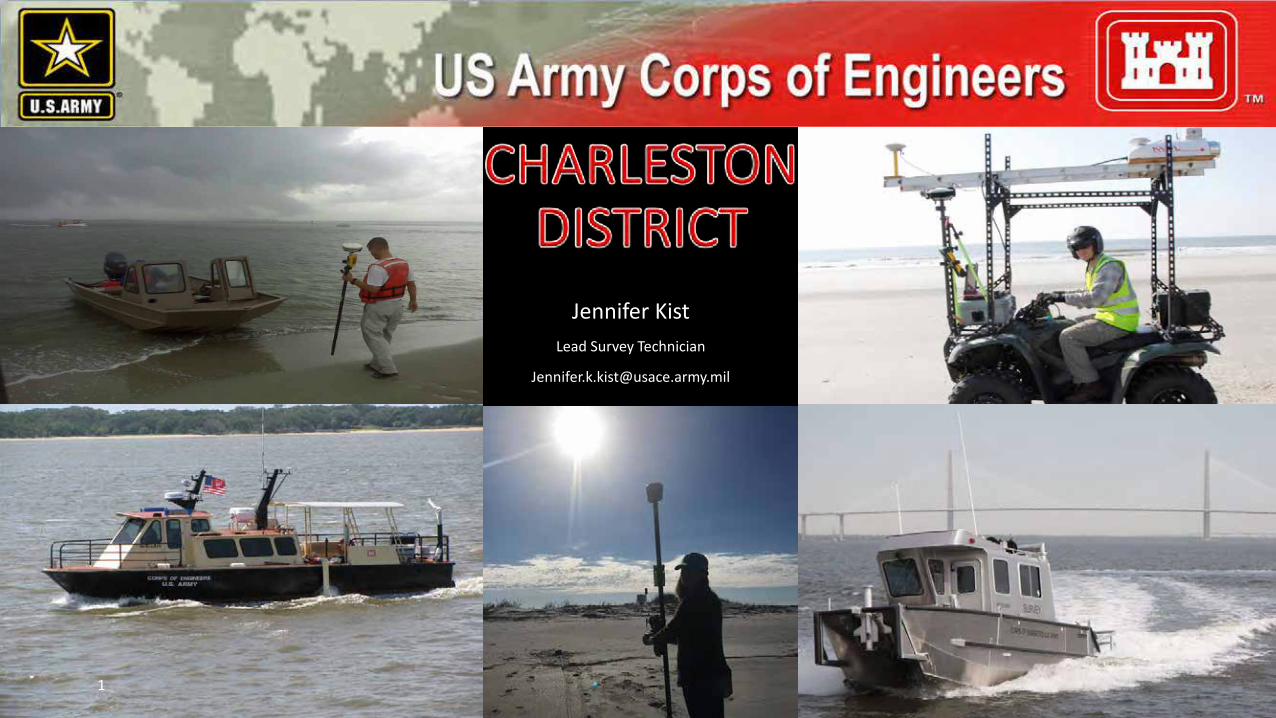
6. Nate Bacheler - NOAA NMFS SE Fishery Survey 7. Jennifer Kist, Matt Boles – USACE Backscatter & Multispectral Backscatter Data
Collection and Access 8. Scott Cross – NOAA NCEI Archives & Data Access 9. Scott Harris - College of Charleston
12:00- 1:00
LUNCH
1:00- 2:15
Southeast Seafloor Mapping Prioritization Objective: Understand and discuss different approaches to prioritization Presenters:
1. Ashley Chappell – NOAA Integrated Ocean and Coastal Mapping (IOCM) 2. Cheryl Hapke – Florida’s Approach 3. Tim Battista – The Interactive Prioritization Approach 4. Ginny Crothers, Christine Buckel - Southeast Seafloor Mapping Prioritization Tool
Group Discussion
2:15- 2:45
BREAK
2:45 - 4:00 How Do We Prioritize Mapping Objective: Gather feedback on the prioritization tool and discuss approach for gathering input.
4:00 - 4:30 Wrap Up Day 1
5:00 Happy Hour
Thursday Apr 19
ACTIVITY
8:30 - 8:45 Welcome Day 2
8:45 - 9:15 Mapping Guidelines and Requirements Objective: Review national standards and outcomes from 2016 workshop with the goal of defining best practices for data collection and mapping.

Presenter: • Chris Taylor – Overview of 2016 Workshop and Terms of Reference
9:15 - 10:30 Mapping Guidelines and Requirements – Breakout Discussion Objective: Further define the requirements (level of detail, resolution, etc.) for seafloor habitat mapping data and products. Breakout Groups:
○ Shallow Water Habitats ■ Subject Matter Experts – Mark Finkbeiner, Don Field ■ Facilitator – Chery Hapke
○ Sand Shoal Habitats ■ Subject Matter Experts – Scott Harris, Katie Luciano ■ Facilitator – Mary Conley
○ Offshore Rocky Habitats ■ Subject Matter Expert – Chris Taylor ■ Facilitator – Adam Bode
10:30- 11:00
BREAK
11:00- 12:00
Mapping Guidelines and Requirements - Report Out Objective: Each breakout lead shares the following information:
1. Level of activity/decision/regulatory decision 2. Level of scale, detail, resolution, biological/geological level required 3. Preferred sensors used and raw data collected (SSS, MBES, etc.) 4. Appropriate attributes or classification scheme required
White Paper Discussion (as time allows)
12:00 - 12:30
Adjourn Closing remarks and plans for follow-on workshops or data sharing.
12:30- 1:30
LUNCH
1:30 - 3:00 Opportunity to Network and Engage Opportunity to further sidebar conversations and ideas, network with new contacts, or leave early based on travel arrangements.
Improving seafloor mapping coordination in the Southeast US coast and outer continental shelf NOAA’s Office for Coastal Management, Charleston, South Carolina
April 18-19, 2018 Terms of Reference
Seafloor habitats from the upper estuary to the outer continental shelf support living marine resources and ecosystems of the Southeast US Atlantic and in turn support the economies of our coastal communities through fisheries, eco-tourism and other services. Maps that depict the arrangement of seafloor habitat types are the foundation from which management agencies guide resource assessments and inform marine spatial planning that seek to limit impacts to habitats and living marine resources from human activities such as ocean energy production and coastal development. As of 2016, less than 12% of the continental shelf (shallower than about 200 meters) of the SE US had been surveyed using modern multibeam sonars. A small fraction of the areas that have been surveyed have been interpreted and classified to geological form or habitat types. In contrast, for estuarine waters, 100% of the seagrass habitats have been mapped in the southeast (NC to FL), though these maps may represent a single time point and may not be repeated to detect change. Vast data gaps exist for structured habitats like oyster reefs in estuarine water and rocky reefs out to the continental shelf break. These gaps impede efficient and informed conservation or regulatory action to minimize potential impacts from human uses of the coastal ocean. In 2016, NOAAs Southeast and Caribbean Regional Collaboration Team identified habitat mapping as a top priority for improving regional coordination among NOAA offices, other state and federal agencies, and academia. The SECART hosted the first of a series of workshops in March 2016 with the following objectives:
● Inventory seafloor survey data available from: NOAA archives or program offices, other government survey data, as well as survey data from industry and academia; Develop an online, open-access dataviewer displaying existing seafloor survey data resources
● Initiate discussion on management needs, requirements for habitat mapping information, and best practices for collecting data to produce habitat maps
● Identify immediate and near-term habitat mapping data priorities by management agencies and research institutions
Participants at the 2016 workshop were asked to identify management needs that require seafloor habitat maps. The top two management calls were: (1) protecting sensitive coral and rocky reef habitats, and (2) improving maps for sand mining and sand resource management. Additional management needs included informing fishery resource assessments, siting offshore energy development, and identifying and conserving historically significant shipwrecks and cultural resources. Participants were also asked to identify the most important seafloor habitat types to focus mapping efforts. These were (1) sand shoals and (2) offshore rocky reefs and deep corals. An additional habitat type also highlighted by participants was (3) shallow estuarine habitats like seagrass and oyster reefs.

Participants selected two breakout groups to identify an initial list of expectations and approaches to mapping (1) sand shoals and (2) offshore rocky reefs. The approaches included level of detail in descriptors or taxonomy of habitat types, and the necessary spatial resolution needed to make management decisions based on prior identification of management needs. The groups also identified appropriate survey sensors and some approaches used to remotely sense the seafloor at resolutions and levels of detail to meet the management needs. The 2018 workshop will build upon the 2016 workshop in three areas:
● Receive additional seafloor habitat mapping data from NOAA offices and external partners, sharing through an online data viewer
● Develop a regional habitat mapping prioritization application for participants to contribute agency and research priorities for habitat mapping to identify mutual areas of interest
● Identify management requirements and summarize best practices for developing seafloor habitat maps in three coastal ocean habitat types:
○ Shallow estuarine habitats including seagrass and oyster reefs ○ Coastal ocean sand shoals ○ Continental shelf rocky reefs and deep coral reefs
To facilitate discussion throughout the workshop, the following terms are defined to establish a common language: Habitat: A description of the estuarine and ocean seafloor relative to its use by living marine organisms. For this workshop it is defined through an hierarchical characterization that includes description of the geological foundation (e.g., fine sediment, hardened materials,man-made structures like shipwrecks, hardened shorelines or purpose-sunk debris and artificial reefs) as well as the biological cover (e.g., attached organisms like algae and grasses, and invertebrates like sponges and corals). Mapping: The process of collecting georeferenced information on the characteristics of the seafloor using direct observation or remote sensing tools like multibeam sonars or airborne optical sensors. Classification: Describing the seafloor habitat types requires a common language and set of terms. The Coastal Marine Ecological Classification Standard (CMECS, https://iocm.noaa.gov/cmecs/) will serve as the accepted dictionary of terms used to define and delineate habitats.

Improving seafloor mapping coordination in the Southeast US coast and outer continental shelf NOAA’s Office for Coastal Management, Charleston, South Carolina
April 18-19, 2018 Day 2 Breakout Session
Developing Guidelines and Requirements for Mapping Seafloor Habitats in the SE Trigger Questions for Breakout Groups A goal of this workshop is to assemble expert practitioners and users of habitat maps to develop guidelines and requirements for seafloor habitat mapping to deliver actionable data for ecosystem management and coastal ocean planning. Breakout groups will be divided among three habitat topics identified during the 2016 SECART Habitat Mapping Workshop: shallow coastal habitats (e.g. SAV, oyster reefs, saltmarsh), nearshore sand shoals, and offshore rocky and deep coral reefs. The following trigger questions will guide the breakout group discussion: Ice-Breaker: What mapping programs are being conducted by your agency/organization? Part 1. Users and Requirements
1. Who are the primary customers for seafloor habitats maps in your focus area? 2. What are the primary management drivers requiring seafloor mapping and related data? 3. What resolution and extent are required for decision making or management actions? 4. How do you receive habitat mapping information?
a. Online-interactive resources b. Digital data shared from owner/source c. Paper maps and printed reports
Part 2. Matching State of Science to Requirements
1. What technical standards or operating procedures exist for mapping your habitat area? 2. What remote sensors are most often used to map your habitat area?
a. List sensor types and platforms used (satellite, airborne, ship, small boats) b. Provide ranges for resolution (e.g., meter x meter, by depth) or other coverage metrics
for sensors as well as resolution for interpreted maps 3. What classification schemes or standards are used in your habitat area? 4. What ground validation methods are used to interpret remotely sensed data?
a. Are accuracy assessments expected by end-users? 5. Are there monitoring or change detection programs in place for your habitat area?
A primary outcome of this session is to develop a stronger network of habitat mapping experts in the region to address needs, share expertise and assets. A NOAA Technical report will be developed from this workshop and breakout sessions with the intended audience including NOAA and partners, from practitioners to end-users, from scientists to regulatory agencies.

12.2 Participant list for workshops

Name Affiliation
Clark Alexander Skidaway Institute of Oceanography
Paul Gayes Coastal Carolina University JP Walsh UNC Coastal Studies Institute Leslie Sautter College of Charleston Scott Harris College of Charleston
Adam Bode NOAA Office for Coastal Management Mark Finkbeiner NOAA Office for Coastal Management Daniel Martin NOAA Office for Coastal Management Chris Taylor NOAA National Centers for Coastal Ocean Science
Tim Battista NOAA National Centers for Coastal Ocean Science Laura Kracker NOAA National Centers for Coastal Ocean Science Andy David NMFS SEFSC Nate Bacheler NMFS SEFSC
Warren Mitchell NMFS SEFSC Mashkoor Malik NOAA Office of Exploration Jeremy Potter NOAA Office of Exploration Kasey Cantwell NOAA Office of Exploration
Kyle Ward Office of Coast Survey (Southeast Navigation Manager) Paul Turner Office of Coast Survey (invite through Ashlee Chappell) Ashley Chappell Office of Coast Survey (Integrated Ocean and Coastal Mapping) Sarah Fangman NOAA Grays Reef National Marine Sanctuary
Tane Casserley NOAA Monitor National Marine Sanctuary Carter Watterson US Navy (request coordinating across DoD) Amanda Demopoulos USGS Bill Schwab USGS WHOI
Cheryl Hapke USGS Brian Hooker BOEM (Renewable Energy) Jennifer Culbertson BOEM (Minerals Management) Kristine Cherry GSAA
Debra Hernandez SECOORA Mary Conley Nature Conservancy Leda Dunmire Pew Sonny Emmert Georgia DNR, Coastal Resources Division
Jessica Boynton SC OCRM/DHEC Ann Deaton NC Div of Marine Fisheries/DEQ Ted Switzer Florida Mel Bell SC DNR
Bob Van Dolah SC DNR Roger Puglise SA Fishery Management Council Chip Collier SA Fishery Management Council Chris Freeman Geodynamics Group, LLC (Pine Knoll Shores, NC)
2016 Southeast Habitat Mapping Workshop Participant List

Name AffiliationDerek Sowers NOAA Ocean Exploration & ResearchDaniel Wagner NOAA NCCOS CharlestonAdam Bode NOAA Office for Coastal ManagementBill O'Beirne NOAA Office for Coastal ManagementLora Turner BOEMAndrew Tweel SCDNRScott White USCPaul Turner NOAA/NOS/IOCMCheryl Hapke USGSChristine Buckel NOAA - NOS - NCCOSNate Bacheler NOAA-NMFS-SEFSC-Beaufort LabChip Collier SAFMCGinny Crothers NOAATane Casserley NOAA Monitor NMSAshley Chappell NOAA IOCMLora Clarke PewPace Wilber NOAA FisheriesScott Harris College of CharlestonAnne Deaton NC DMFJessica Boynton SCDHEC - OCRMDon Field NOAA/NOS Beaufort LabMary Conley The Nature ConservancyChris Taylor NOAA NCCOSMark Finkbeiner NOAA-OCMKatie Luciano South Carolina DNRLiz Fly The Nature Conservancy South CarolinaWilliam Chappell NavyDave Bernstein GeodynamicsScott Cross NOAA NCEITim Battista NCCOSBrad Pickens NOAA NCCOSAlexa Ramierz Quantum SpatialMarcel Reichert South Carolina DNRRachel Bobich South Carolina DNRPhil Wolf USACEPaul Gayes Coastal Carolina UniversityJennifer Kist USACE Till Hanebuth Coastal Carolina UniversityClark Alexander Skidaway Institute of OceanographyRick DeVoe S.C. Sea Grant ConsortiumJennifer Dorton SECOORA
Attending Remotely Kasey Cantwell NOAA OERLaura Kracker NOAA NOS NCCOSGeorge Sedberry retired (at that point)Jason Chaytor USGSErik Cordes Temple UniversityCaitlin Adams NOAA OERRichard Viso Coastal Carolina UniversityTodd Kellison NOAA - NMFSHeather Coleman NOAA Fisheries, Office of Habitat Conservation Nick Farmer NOAA FisheriesKen Buja NOAAReide Corbett East Carolina UniversityLeslie Sautter College of Charleston - BEAMS Program
2018 Southeast Habitat Mapping Workshop Participant List

12.3 Presentation from 2018 workshop

You Have Data, We All Have DataPresentations
1. Collected Data - Christine Buckel2. NOAA IOCM, Avenues for
Collaborative Mapping, 3D National Study – Ashley Chappell, Paul Turner
3. BOEM Marine Minerals Information System (MMIS) –Lora Turner
4. SC DNR / BOEM State Sand Cooperative Update – Andrew Tweel

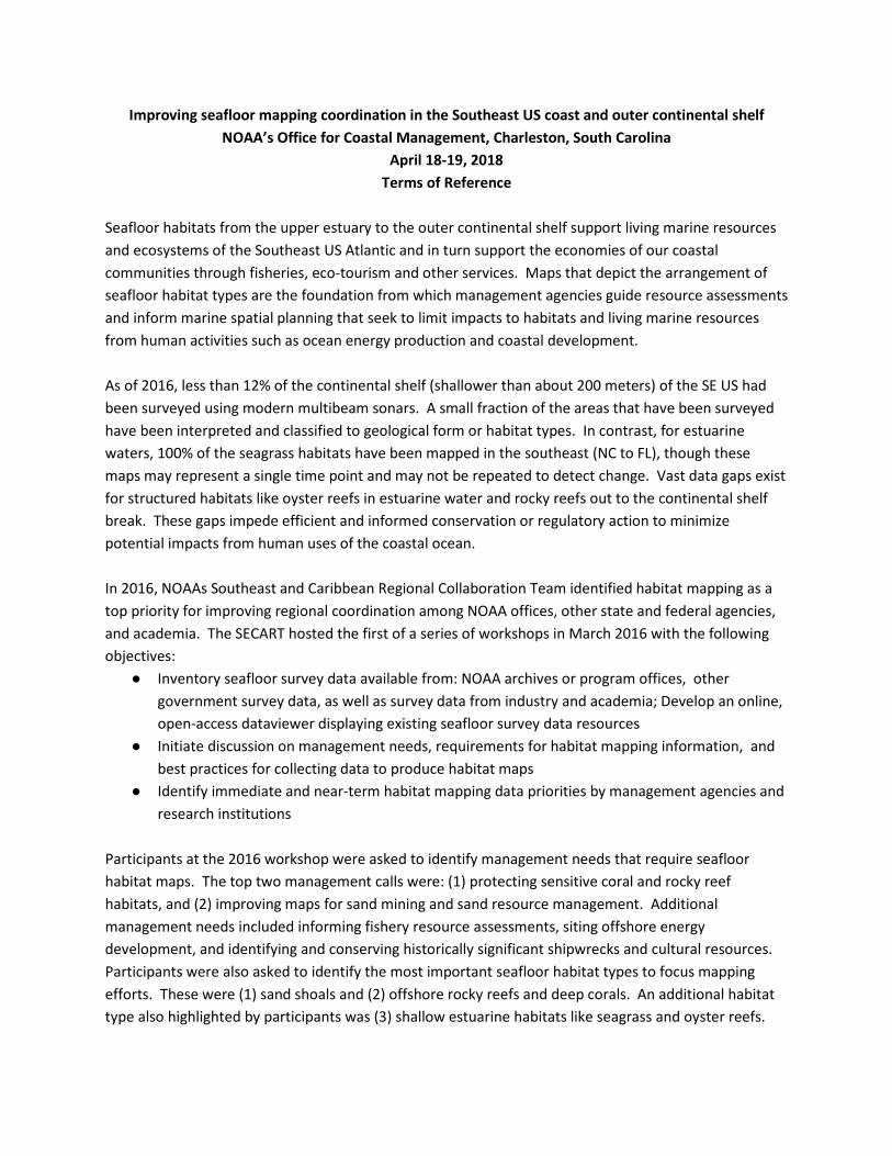
Building a map of where we’ve mapped…
Building a map of where we’ve mapped…

Building a map of where we’ve mapped…

Building a map of where we’ve mapped…


Next Steps:• Data inventory are background of the prioritization
tool• Footprints integrated with SeaSketch and other
online mapping resources
• Can be updated with your data –– Formally archive your data (for NCEI - talk with Scott) – Send [email protected] footprints of your data
(toolbox will be distributed with meeting materials)

You Have Data, We All Have DataPresentations
1. Collected Data - Christine Buckel2. NOAA IOCM, Avenues for
Collaborative Mapping, 3D National Study – Ashley Chappell, Paul Turner
3. BOEM Marine Minerals Information System (MMIS) –Lora Turner
4. SC DNR / BOEM State Sand Cooperative Update – Andrew Tweel

You Have Data, We All Have DataPresentations
5. NOAA Okeanos / OER Plans –Derek Sowers, Kasey Cantwell
6. NOAA NMFS SE Fishery Survey –Nate Bacheler
7. US Navy Collection of Benthic Habitat Data – Scott Chappell
8. USACE Data Collection & Access –Jennifer Kist, Matt Boles
9. NOAA NCEI Archives & Data Access – Scott Cross
10. College of Charleston / BEAMS Program – Scott Harris

Southeast Seafloor Mapping Prioritization
1. NOAA Integrated Ocean and Coastal Mapping Program (IOCM) Ashley Chappell
2. Florida’s Approach Cheryl Hapke
3. A Prioritization Approach Tim Battista
4. Southeast Seafloor Mapping Prioritization Tool Ginny Crothers, Christine
Buckel

SE Seafloor Mapping Prioritization
Goals of the Tool• Assist SECART and partners in
prioritizing and coordinating seafloor habitat mapping in the SE Atlantic
• Visualize existing data and protected and managed areas in the region
• Identify your organization’s priorities for future seafloor mapping
Objectives for Today• Introduction of tool through demo• Receive initial feedback (see survey
handout!)
Thanks to Ken Buja and Tim Battista (NOS/NCCOS) for their development of the prioritization tool

Next Steps
Get feedback today on the tool and prioritization parameters Please fill out the survey provided!
Identify agency representatives (April 26) Email [email protected]
Distribute user guide and launch tool (early May) Receive submissions for priority areas (June 1) Aggregate priority mapping areas and utilize in inter-agency planning
Thank you for your participation!Ginny Crothers
JHT, Inc. for [email protected]
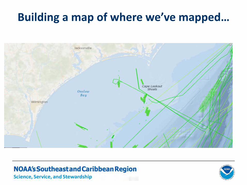
How Do We Prioritize Mapping?
1. Why are we mapping?2. Where is that important?3. Best approach for gap analysis?4. What information do we have or
need?5. Where might we join forces of
mapping project(s)?

Day 2 Outline
8:30 – 8:45 Welcome and Day 1 Summary 8:45 – 9:15 Mapping Guidelines & Requirements9:15 – 10:30 Breakout Group Discussion10:30 – 11:00 Break11:00 – 12:00 Breakout Group Report Out 12:00 – 12:30 Adjourn12:30 – 1:30 Lunch1:30 – 3:00 Opportunity to Network & Engage

Summary from yesterday
• Interpreting habitats from hydrographic multibeam surveys– a new method, still depends on the best quality elevation
data (and likely backscatter in the SE)
• Lots of activities in our region• Lots of data being made more readily available
– URL from presentations will be shared in workshop report
• Federal agencies are looking for input on where to map in the SE (Exploration, Charting, Habitats)

Summary from yesterday
• Prioritizing seafloor mapping in the SE– It is a VERY large area– Be sure to include EVERYBODY, but at what level within
large organizations (esp. Federal agencies)– How much time is needed to provide useful input to
prioritization– What is the schedule of upcoming resource allocation
decision making?Is it reasonable to distribute SE Prioritization Tool? What is a reasonable timeline?

Day 2 Outline
8:30 – 8:45 Welcome and Day 1 Summary 8:45 – 9:15 Mapping Guidelines & Requirements9:15 – 10:30 Breakout Group Discussion10:30 – 11:00 Break11:00 – 12:00 Breakout Group Report Out 12:00 – 12:30 Adjourn12:30 – 1:30 Lunch1:30 – 3:00 Opportunity to Network & Engage

Mapping Guidelines & RequirementsBreakout Groups
GOAL: Identify management drivers and requirements for habitat maps and summarize best-practices for mapping habitat types/areas
ShallowSAV and Oysters
Nearshore Sand/Shoals
OffshoreRocky/coral reefs
Experts Field/Finkbeiner Luciano/Harris Taylor
Facilitator Hapke Bode Conley
Notes Chappell Crothers Buckel
Location

Mapping Guidelines & RequirementsTrigger Questions
Part 1. Users and Requirements1. Who are the primary customers for seafloor habitats maps in your focus
area?2. What are the primary management drivers requiring seafloor mapping and
related data?3. What resolution and extent are required for decision making or management
actions?4. How do you receive habitat mapping information?
• Online-interactive resources• Digital data shared from owner/source• Paper maps and printed reports

Mapping Guidelines & RequirementsTrigger Questions
Part 2. Matching State of Science to Requirements1. What technical standards or operating procedures exist for mapping your
habitat area?2. What remote sensors are most often used to map your habitat area?
• List sensor types and platforms used (satellite, airborne, ship, small boats)
• Provide ranges for resolution (e.g., meter x meter, by depth) or other coverage metrics for sensors as well as resolution for interpreted maps
3. What classification schemes or standards are used in your habitat area?4. What ground validation methods are used to interpret remotely sensed
data?• Are accuracy assessments expected by end-users?
5. Are there monitoring or change detection programs in place for your habitat area?


Breakout Group Report OutReport Out
1. Level of activity, decision, regulatory decision
2. Level of scale, detail, resolution, and biological/geological level required
3. Preferred sensors used and raw data collected (SSS, MBES, etc)
4. Appropriate attributes or classification scheme required
5. What information do we have or need?
White Paper Discussion

Georgia Regional Status Update
Clark AlexanderSkidaway Institute of Oceanography
University of Georgia

2.5+/-2.2 Φ
2.4+/-1.2 Φ
2.4+/-0.9 Φ
1.5+/-0.8 Φ


Use of multibeam sonar by the Southeast Fishery-Independent Survey
Nate BachelerNational Marine Fisheries Service
Southeast Fisheries Science CenterBeaufort, NC

Southeast Fishery-Independent Survey (SEFIS)• Began in 2010• Work with SCDNR-MARMAP• Reef fish sampling program• Use chevron traps and video• Target hardbottom habitats• Cape Hatteras to south FL
U.S. Department of Commerce | National Oceanic and Atmospheric Administration | NOAA Fisheries | Page 2

Why has multibeam sonar been used by SEFIS?
U.S. Department of Commerce | National Oceanic and Atmospheric Administration | NOAA Fisheries | Page 3
2009

How has multibeam sonar been used by SEFIS?
SEFIS obtains hardbottominformation from many sources: • Fishermen• Drop cameras• Fishing charts• Observers• Agencies• Predictive maps• Fishery sonars
U.S. Department of Commerce | National Oceanic and Atmospheric Administration | NOAA Fisheries | Page 4

U.S. Department of Commerce | National Oceanic and Atmospheric Administration | NOAA Fisheries | Page 5

What ships have been used by SEFIS for mapping?
2010: NOAA Ship Nancy Foster
U.S. Department of Commerce | National Oceanic and Atmospheric Administration | NOAA Fisheries | Page 6
2011-2017: NOAA Ship Pisces
Simrad ME-70Operated ourselves
Reson 7125Operated by survey techs

U.S. Department of Commerce | National Oceanic and Atmospheric Administration | NOAA Fisheries | Page 7
Map quality from Nancy Foster?

U.S. Department of Commerce | National Oceanic and Atmospheric Administration | NOAA Fisheries | Page 8
Map quality from Pisces?
Poor quality but useful
2011

U.S. Department of Commerce | National Oceanic and Atmospheric Administration | NOAA Fisheries | Page 9
Slightly better quality
2012-13
U.S. Department of Commerce | National Oceanic and Atmospheric Administration | NOAA Fisheries | Page 10
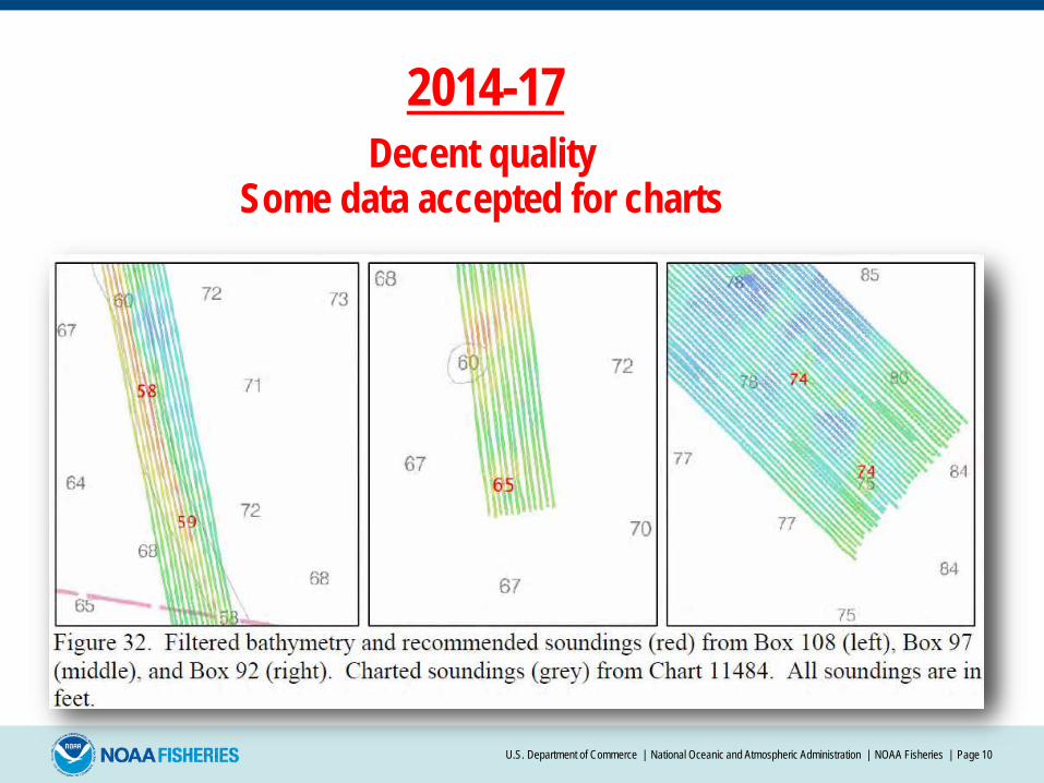
Decent quality2014-17
Some data accepted for charts

Annual mapping totals
U.S. Department of Commerce | National Oceanic and Atmospheric Administration | NOAA Fisheries | Page 11
Year Total mapping (km2)
2010 350
2011 150
2012 385
2013 259
2014 250
2015 0
2016 465
2017 302
TOTAL 2,161

Sample universe expansion due to sonar mapping
U.S. Department of Commerce | National Oceanic and Atmospheric Administration | NOAA Fisheries | Page 12
2009 2017

Future needs for multibeam data
• Any multibeam data in southeast USA between 13 and 200 m deep
• Any information on locations and extent of hardbottom
• Sonar maps classified into various habitat types is very helpful
U.S. Department of Commerce | National Oceanic and Atmospheric Administration | NOAA Fisheries | Page 13

Acknowledgements
• NOAA Fisheries SEFSC staff: Warren Mitchell, David Berrane, Zeb Schobernd, Christina Schobernd, Charles Thompson, Brandi Noble
• Glen Rice, Matt Wilson, Laura Kracker• Sonar watch standers: SCDNR and College of Charleston students• Tom Weber, University of New Hampshire• Randy Cutter, NOAA Fisheries SWFSC• Josh Mode, Teledyne CARIS • NOAA ship Nancy Foster and Pisces crew, officers, ETs, and STs,
augmenting Survey Technicians• SCDNR-MARMAP
U.S. Department of Commerce | National Oceanic and Atmospheric Administration | NOAA Fisheries | Page 14

A Process to Prioritization
Seafloor Mapping
Tim Battista NOAA’s Ocean ServiceMarine Spatial Ecology DivisionHabitat Mapping Team
January 10, 2018
FL Coastal Mapping Program Workshop
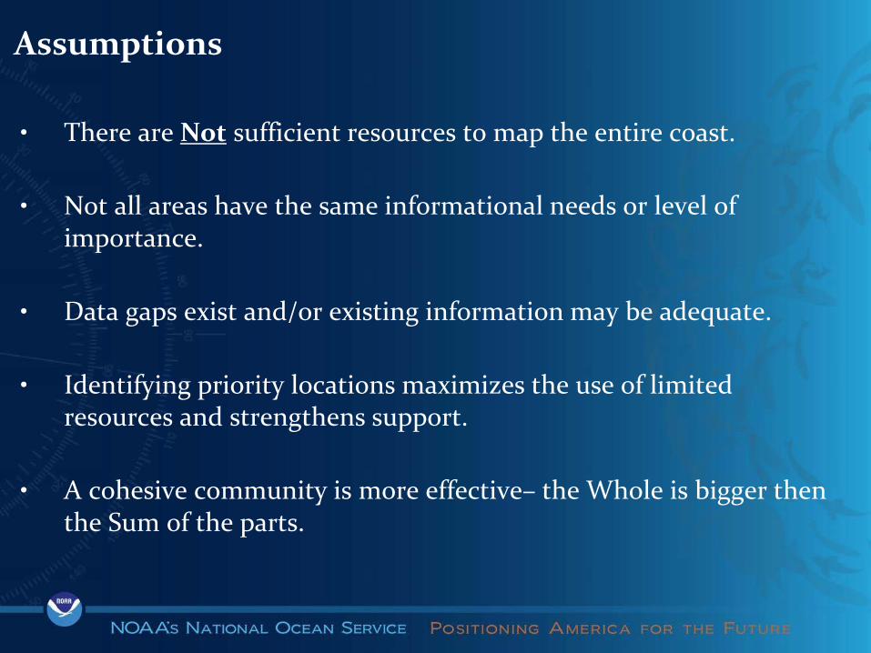
• There are Not sufficient resources to map the entire coast.
• Not all areas have the same informational needs or level of importance.
• Data gaps exist and/or existing information may be adequate.
• Identifying priority locations maximizes the use of limited resources and strengthens support.
• A cohesive community is more effective– the Whole is bigger then the Sum of the parts.
Assumptions

• “Where” - Solicit independent “priorities” from Agencies and Tribes. Seek convergence across all entries.
• “Why” - Capture the underlying management or planning need driving the priority. Use this to target products, technology and approach.
• Codify the community towards better collaboration, and addressing broader requirements.
• Embrace common collection standards, shared data, and shared resources.
• Invigorate future investments.
Objectives

• Long Island Sound - 2012 (Battista & O’Brien 2015. Coastal Management, 43: 35-51)
• US Caribbean - 2013
• Washington State – 2015(Battista, T., Buja, K., Christensen, J, Hennessey, J., and K. Lassiter. Prioritizing Seafloor Mapping for Washington’s Pacific Coast. Sensors, 17(4), 701)
• Southern California Bight - 2016
• Lake Michigan - 2017
Implementation

Phase 1: Spatial Prioritization (SP) Pre-Planning (TAT). June – Sep ‘14
Phase 2: SP Planning Workshop I (TAT & Stakeholders). Oct ‘14
Phase 3: SP Exercise. (Jan 29 to Mar 18 ‘15)
Phase 4: SP Workshop II (TAT & Stakeholders). May ‘15
✓✓✓
Project Timeline
✓

Spatial Prioritization Exercise
Analyze Priority Areas
Refine Priority Areas
Develop Priority Narratives
Select Mapping Product
Categories
Where And Why
Why2
What
Workshop 2 Objectives

• Project AOI defined by WA Marine Spatial Planning study area.
• 700 fathoms to shoreline “zone”.
• Based Standard OCS blocks of 4.8 x 4.8 km (3 x 3 mi)
• 996 grid cells
Study Area

Use relevant WMS:• TNC Regional Data • MarineCadastre.gov • WA Marine Spatial Planning Portal
• Project Boundary and Grid• Marine Infrastructure• Critical Habitat• Managed Areas
• Survey Extents• Interpreted Geological
Surfaces• Hydrography
Digital Atlas

1. Token● 100 Coins● Semi-quantitative● More specific● “If I had a hundred
dollars…”
2. Categorical● Qualitative● More general● H needed in 1-2 years● M needed in 3-5 years● L needed eventually
RULE: 10 coin maximum in
a cell
RULE: 1/3 of cells must be
in each category
Prioritization Approaches

Priority:• A relative measure of the need for seafloor
mapping information for a grid cell. • (High, Medium, Low, or None)• Limited High and Medium votes (1/3 ea.)
Set Categories + Forced Input Constraint Approach:
Management Issue:• Overarching management issue (by grid
cell) driving the “Priority” designation. • 11 Set choices. Must choose one.
Ranking Criteria:• Describes the Management Issue further. • 8 Set choices. Must Choose one.• Optional Ranking Criteria 2 and 3.
Respondent Input


Web AppBuilder for ArcGIS
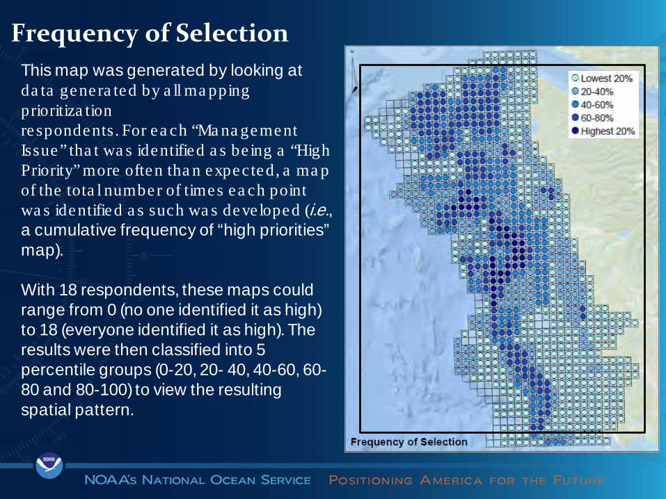
This map was generated by looking at da ta genera ted by a ll ma pping prioritiza tionrespondents. For ea ch “Ma na gement Issue” tha t wa s identified a s be ing a “High Priority” more often tha n expected, a ma p of the tota l number of times ea ch point wa s identified a s such wa s deve loped (i.e., a cumulative frequency of “high priorities” map).
With 18 respondents, these maps could range from 0 (no one identified it as high) to 18 (everyone identified it as high). The results were then classified into 5 percentile groups (0-20, 20- 40, 40-60, 60-80 and 80-100) to view the resulting spatial pattern.
Frequency of Selection

Living Resource Management
Ecosystem Based Management
Coastal Inundation
Other Regulatory Issues
Research SedimentManagement
Hot Spot Analysis – Significant Management Issue
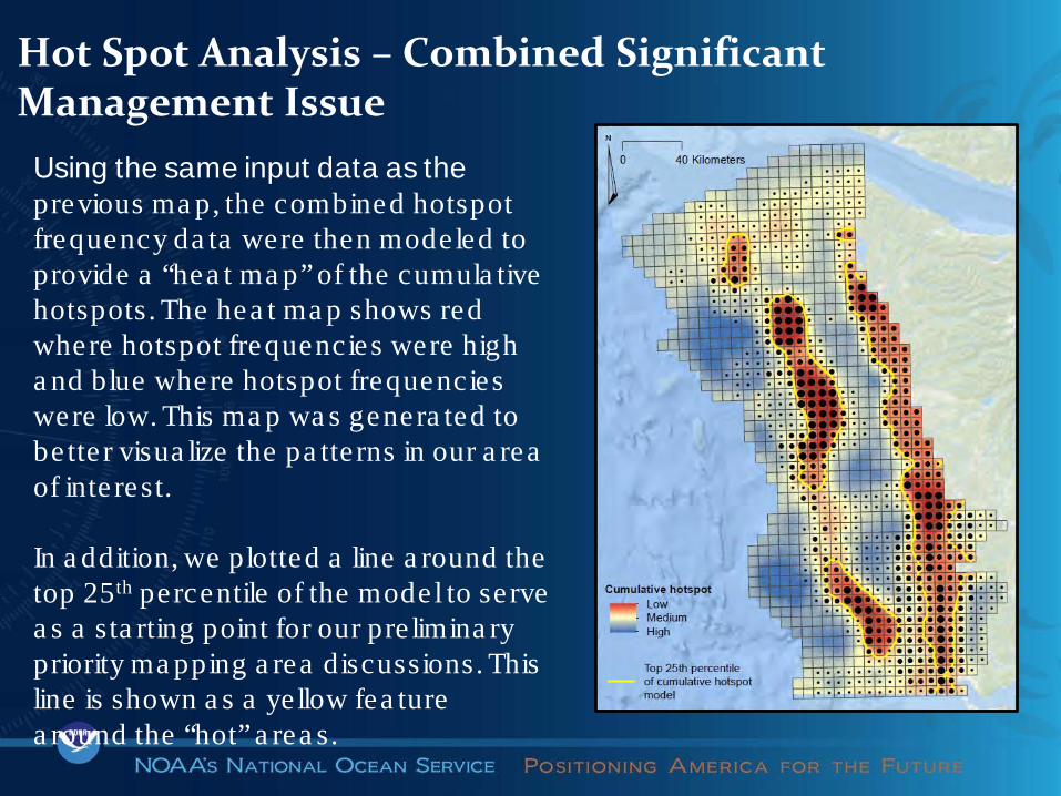
Using the same input data as the previous ma p, the combined hotspot frequency da ta were then modeled to provide a “hea t ma p” of the cumula tive hotspots. The hea t ma p shows red where hotspot frequencies were high a nd blue where hotspot frequencies were low. This ma p wa s genera ted to be tte r visua lize the pa tte rns in our a rea of inte rest.
In a ddition, we plotted a line a round the top 25th percentile of the model to se rve a s a sta rting point for our pre limina ry priority ma pping a rea discussions. This line is shown a s a ye llow fea ture a round the “hot” a rea s.
Hot Spot Analysis – Combined Significant Management Issue

WA Prioritization Results
This map identifies all of the cells in the origina l a rea of inte rest tha t inte rsect –or tha t a re conta ined within – the 25th percentile bounda ry of the cumula tive hotpot model.
From which ca n conduct Pa rtic ipa tory GIS (PGIS) to re fine a rea s further.

Develop Support Narrative for each Priority Area

Individual Agencies

2016/17 Nautilus – 5 DAS2016/17 Rainier – 20 DAS2018 Rainier – ? DAS
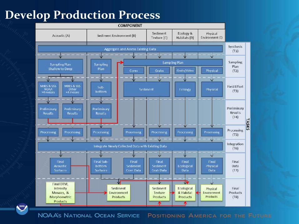
Develop Production Process

LIS Prioritization Results

2015 Nancy Foster – 25 DAS2014 Thomas Jefferson – 72 DAS2014 Twin Otter – 24 DAS
2013-14 NRT 5 – 92 DAS2013 Thomas Jefferson – 35 DAS2012 Thomas Jefferson – 56 DAS

LIS Cost & Survey Planning

https://maps.coastalscience.noaa.gov/wilm
https://maps.coastalscience.noaa.gov/wasp/wasp.html
Demonstration
Washington
Lake Michigan

Thank You!Tim Battista – NOAA’s Ocean Service
National Centers for Coastal Ocean ScienceSilver Spring, MD

IOCM Update 2018 SE Seafloor Mapping
WorkshopAshley Chappell
Paul TurnerNOAA's Office of Coast Survey
Integrated Ocean and Coastal Mapping
March 6, 2018 “Map Once, Use Many Times”

IOCM is planning, acquiring, integrating, and managing ocean and coastal geospatial data and derivative products for easy access and use by the greatest range of users.
What is IOCM
“Map Once, Use Many Times”
Three primary tasks:
1. Data Acquisition2. End‐to‐End Data Management
3. Maximum Use and Re‐Use of data
Coordinate & Collaborate:• Avoid costly duplication
of effort• Maximize survey time• Meet multiple science &
mission requirements• Enables & promote
cross‐agency collaboration

IOCM General Update:• OCS, RSD plans incl hurricane supplemental
– Increased water column data acquisition – where/when possible• 3D Nation Study update, Seabed 2030• External Source Data, Crowd-source Bathy• Working with OMAO to incorporate an IOCM section into the
OMAO Project Instructions for FY19• Re-designed NRT Mission Focus• Regional Mapping Workshops: WA State, FCMP, GOMA,
SE, and NE– Mapping Prioritizations

NOAA Coast Surveyand
NGS Remote Sensing DivisionPlans
HSD Story Map

Mapping a 3D Nation:Requirements and Benefits Study Goals
Offshore Apalachicola
A comprehensive inventoryof user requirements andbenefits for e leva tion da ta
• Refresh NEEA for the years beyond the initia l 8-year acquis ition program
• Unders tand inland, nearshore , and offshore ba thymetric da ta requirements and benefits
• Unders tand how requirements and benefits dove ta il in the coas ta l zone
• Sensor agnos tic/Technology Neutra l • Focused on need for, and va lue of, e leva tion da ta

Seabed 2030 Initiative
Offshore Apalachicola
Global initiative led by The Nippon Foundation and the General Bathymetric Chart of Oceans (GEBCO) Guiding Committee to facilitate the complete mapping of the ocean floor by the year 2030.
Target Resolutions:
NOAA’s Bathymetric Data Gap Analysis for Seabed 2030

Seabed 2030 How you can contribute
Offshore Apalachicola • U.S. is responsible for U.S. waters – EEZ, shelf• 24 govt/research institutions, universities, businesses already participating, and this number is growing• First big step – Discovery, sharing of existing data to fill gaps▪ Anything not already at NCEI or other accessible site▪ Agency, partner, stakeholder data with good metadata• Agreement on, and use of, common standards• Sharing of plans at FEDMAP and collaborative mapping campaigns to fill more gaps• IHO Crowdsourced Bathymetry initiative
U.S. Mapping Agencies and Partners will be KEY

8NATIONAL CENTERS FOR ENVIRONMENTAL INFORMATION
IHO Data Center for Digital Bathymetry
Recognized IHO repository for all deep ocean bathymetric data (greater than 100 m) collected by hydrographic, oceanographic and other vessels.
Data are sent to the IHO DCDB, where NCEI provides long term archive and data management.
www.ngdc.noaa.gov/iho/

U.S. Federal Mapping Coordination Sitefedmap.seasketch.org
Offshore Apalachicola
• Seasketch is an online tool to share info on acquisition plans, data needs and project coordination
• Variety of tools available for use – forums, sketching

2019 Potential Collaborative IOCM/OCNMS Mapping Project
• Seafloor Mapping Prioritization Heat Map for Washington’s Coast
• Nearshore and Offshore
• IOCM, OCNMS, WA State collaborative mapping project on NOAA Ship RA: 2016 – 2017
• Working with OCNMS for a potential 2019 or 2020 collaborative project in the nearshore area in Central WA.

Hydro Health Survey Prioritization
● Goal: Identify project-sized survey areas, prioritized by worst Hydro Health○ Apply depth-varying filter to
smooth Hydro Health output
○ Identify areas of clustered poorest health
○ Expand area until reasonable project size is reached
(note: preliminary results. Graphic illustrates desired end results for survey prioritization)

Okeanos Explorer 2018 Gulf of Mexico & Atlantic Exploration
• 2018 OER Mapping & ROV missions– 3 deep-water operation project
areas– Submitted AOI for all 3 areas– GOM project is underway– Call for input technically closed
for Atlantic project areas but…

Overall Project Area• Managed by FIO and USF• High resolution mapping project to
characterize and assess habitat and fish communities in the West Florida Shelf
• Attended steering community group meetings since 2015
• HSD incorporated the VMS as a layer into the HHM
• Data is acquired to meet NOAA’s hydrographic data specifications
• Primary data products: MB, Backscatter and habitat classification maps coupled with imagery from towed camera array – CBASS
Mapping Progress
C-SCAMP: West Fl Shelf Mapping Projecthttp://www.marine.usf.edu/scamp/index.php

USGS, USACE, USFWS, USFS, Florida Institute of Oceanography, FL FWC, FL DEP, USF College of Marine Science,
Big Bend (Florida) IOCM ProjectExternal Project Partners & Contributions
Florida Institute of Oceanography
▶ Partnering academic organization with two oceanographic survey vessels (for charter) equipment with full complement of ocean mapping survey equipment.
▶ In addition, FIO has collaborating scientists to contribute to data acquisition and processing and will be pivotal during stakeholder outreach in the working area.
USACE & NGS
▶ Topo‐bathy lidar surveys of the northern Gulf of Mexico coastline as part of its mission for shoreline mapping.
Florida Department of Environmental Protection
▶ Partnering academic organization with two oceanographic survey vessels (for charter) equipment with full complement of ocean mapping survey equipment. In addition, FIO has collaborating scientists to contribute to data acquisition and processing and will be pivotal during stakeholder outreach in the working area.
Estimated Resources
Broad funding requests for year 1 with follow‐on funding for year 2.
Year 3 will involve data processing and product development using base funds.
Estimated Project LengthData acquisition and field operations not to exceed 2 years.
Data processing and final deliverable(s) computation not to exceed 1‐2 years.
Full project duration of 3 years.
This effort will include high priority areas identified in collaboration with NOS program offices (OCS, CO‐OPS, NGS, IOOS/GCOOS, NCCOS), NMFS (Southeast Fisheries Science Center) and the following external partners:
Total funding request: $935,000

Building and Maintaining a Comprehensive Database and Prioritization Scheme for
Overlapping Benthic Habitat DataW. Scott Chappell &
Jonathan Crain
Supported Command
USWTR BottomHabitats and ROV Transects

BACKGROUND & INTRODUCTION
The seafloor resource data used in the Phase IIenvironmental compliance cycle (beginning in 2013)for Atlantic Fleet Training and Testing (AFTT)activities was:
1. Limited to regional or Navy source coverages (building on the Marine Resource Assessments); and
2. Combined such that broad-scale, lower quality data could override fine-scale, higher quality data
3. Used in developing mitigation areas for bottom-placed explosives, military expended materials, and seafloor devices.

Refinements for AFTT Phase III Cycle (beginning in 2018)
(1) Build and maintain comprehensive database of mapping sources;
(2) Combine maps such that fine-scale, higher quality data replaces broad-scale, lower quality data; and
(3) Update seafloor resource mitigation areas with new data.

Example Source: Barnhardt et al. (1996)
FOCUS OF PRIORITIZATION SCHEME AND HIERARCHY: ABIOTIC SUBSTRATE
Intermediate
Soft
Hard
• Water Flow/Qualitymapped from global satellite data in the EIS/OEIS(s);
• Bathymetry/ Topography from a single assemblage of sources for the EIS/OEIS(s); and
• Biotic Feature Classeswere included in the database as mostly state-level, non-overlapping datasets for the AFTT EFHA only.

BENTHIC HABITAT DATABASE FOR RANKING MAPPING SOURCES (Microsoft Assess Form)

DISTRIBUTION OF ABIOTIC SUBSTRATE DATA SOURCES IN THE SOUTH ATLANTIC

Navy Data Sources for the South Atlantic
(1) Naval Oceanographic Office a) Assemblage data: 500 – 3,000 m resolution interpolation
of benthic grab samples & chart bathymetry (unclassified);
b) High resolution ship track and survey area data from acoustic sensors with validation (classified);
(2) Project specific mappinga) Validated MBES mapping of USWTR and CC box in the
Jacksonville Range Complex (unclassified but not publically available);
b) Mapping of biological resources within installation waters using point and transect methods (unclassified but not publically available)

QUESTIONS?

1NATIONAL CENTERS FOR ENVIRONMENTAL INFORMATION
Multibeam Bathymetry Dataat NCEI
NOAA National Centers for Environmental Information (NCEI), Boulder, United States
(Scott Cross for)
Aaron RosenbergMB data manager
IHO CSB Project technical lead

2NATIONAL CENTERS FOR ENVIRONMENTAL INFORMATION
Multibeam Data at NCEI - Snapshot
• Over 50 TB currently archived• Roughly 17 TB online and available for download• Over 2600 published cruises
• 1980 to present• 39 data providers• 61 sonar instruments• 100 collection platforms• 127 data file types
• multibeam, metadata, ancillary• Data consist of more than 17 million km of along
track coverage

3NATIONAL CENTERS FOR ENVIRONMENTAL INFORMATION
NCEI Bathy Data Viewer

4NATIONAL CENTERS FOR ENVIRONMENTAL INFORMATION
Multibeam Data Access
• Multibeam Bathymetry Database (MBBDB)• doi:10.7289/V56T0JNC
• NCEI map viewers• bathymetry viewer
• Text search• multibeam survey search
• Gridded products• AutoGrid
• Email requests – [email protected]• delivery via FTP or external hard drive

5NATIONAL CENTERS FOR ENVIRONMENTAL INFORMATION
Multibeam Data Ingest
• Data submission
• Metadata scraping and trackline generation
– MB-System
• Populate the database– Cruise level – File level
• ISO metadata generation
• Archive
• Publish

6NATIONAL CENTERS FOR ENVIRONMENTAL INFORMATION
Contact
Aaron RosenbergMB data manager
IHO CSB Project technical [email protected]

7NATIONAL CENTERS FOR ENVIRONMENTAL INFORMATION
Contributor: Rolling Deck to Repository (R2R)
Data flow for University-National Oceanographic Laboratory System (UNOLS) - the U.S. academic research fleet - shipboard collected data (cruise catalog)
• Over 12 TB data• 909 cruises contributed
• 11 contributing platforms

8NATIONAL CENTERS FOR ENVIRONMENTAL INFORMATION
Contributor: NOAA Office of Ocean Exploration and Research (OER)
• The only U.S. federal organization currently dedicated to exploring our unknown ocean
• Manages data for the NOAA Ship Okeanos Explorer
• Has provided data from over 100 cruises (with more available through the OER Digital Atlas)

Florida Coastal Mapping Program
Accessible, high resolution seafloor data of Florida’s coastal waters to support infrastructure, benthic habitat mapping, restoration projects, resource management, emergency response, and coastal resiliency and hazard studies for the citizens of Florida.
Vision
Coordinate across Federal and FL State agencies, and other stakeholders, to build a comprehensive understanding of the Florida coastal seafloor.
Mission

FishermenResearchersCoastal residentsEnvironmental managersResource managersRecreational boatersBeach goers
Coastal cities and counties Maritime transportationPortsSurfersMarine fisheries
Who Benefits?
• New technologies and processing tools allow for efficient mapping
• Increasing threats from storms and sea level rise• Increasing pressure on marine resources and fisheries
Why Now?

Florida Coastal Mapping Program – Organizational Chart
Florida Institute of Oceanography U.S. Geological SurveyCo-chairs
FL Fish & Wildlife Research Institute
FL Dept. of Environmental Protection and FL Geological Survey
National Oceanographic & Atmospheric
Administration
U.S. Army Corps of Engineers
U.S. Bureau of Ocean Energy Management
SteeringCommittee
USFCollege of Marine Science
U Miami Rosenstiel School of Marine &
Atmospheric Science
NOVA Southeastern University
FL Atlantic University
Technical Team
FL Dept. of Emergency Management

Florida Coastal Mapping Program
Jan. 2017: stand up Steering Committee • 3 State, 4 Federal agencies
Feb 2017 – Dec 2017: Technical Team• Compile inventory of existing coastal seafloor
mapping data • Populate portal with footprints and metadata• Conduct gap analysis
Jan 2018: Partner & stakeholder workshop

Acoustic data:• Multibeam bathymetry (2-200 m)• Sub-bottom Chirp (0-200 m)• Side Scan Sonar (0-200m)• Seismic Profiling (boomer)
Optical data: • Bathymetric Lidar (seafloor bathymetry to 10m)• Coastal Lidar (coastal elevation and very shallow
water bathymetry)
Technical Team Data Inventory and Portal

6 Regions for Gap Analysis and Prioritization
• Panhandle• Big Bend• West FL Peninsula• FL Keys• SE Coast• NE Coast

Values are percent unmapped

Workshop Outcomes
A collective understanding of the current state of coastal seafloor bathymetry of the State of Florida
Guidance for future mapping projects and funding priorities
The foundation to help inform a multi-year strategy to fill critical gaps
Suggested minimum mapping standards:• 20-200 m: to IHO standards for future mapping (10m DEM)• 0-10 m: lidar resolution to support 1m DEM• 10-20 m: lidar or multibeam to support 1m DEM (ideally) or 3m
(minimum)
Over 75 attendees at workshop; next steps – report, prioritization, outreach, regional workshops, portal development, funding strategy

Funding/Next Steps• Immediate: Funding for a coordinator/technical position
• Develop a funding strategy for high-resolution bathymetry (HRB) that includes federal and state sources and an action plan for undertaking the required mapping within 10 years
• Update Portal with missing data & planned/funded federal efforts
• Determine minimum habitat resolution standard for derived products
• Prioritize coastal seafloor mapping by region
• Take-away: Map once, use many times

MMIM BOEMGOMOSES Benthic Habitat Workshop GOMAFL DOI RESTORE USGSGulfwide DOI RESTORE FWSIWG-OCM NOAAIWG-OCM USGS3D Nation USGS FL Liaison3D Nation FL State ChampionSoutheast Comprehensive Study USACE - JacksonvilleSEACART NOAACMAP NOAAHSRP NOAA2017 Storm Supplemental NOAA2017 Storm Supplemental USACEMMP FWRIMonitoring Community of Practice GOMA
FCMaP
Linking FCMaP to Other Mapping Efforts
SeaSketch: FCMaP Partners Project

Big Bend Demonstration Study• Multi-mission, multi-agency demonstration of capabilities of
FCMaP members to address coastal priorities
• In alignment with CMAP and MMP, develop and implement a 3-tier approach for establishing a workflow for Gulfwide RESTORE projects:1. High resolution baseline elevation data2. Derivative products (e.g. benthic habitat maps)3. Visualization and outreach
• Multibeam, topobathy lidar, sidescan sonar, subbottom, ground-truthing
• 1-day workshop during GOMA All-hands (June 2018); stakeholder workshop in Cedar Key (late summer 2018) to include prioritization

Mission
Area of Responsibility
Data Availability
Our Data

Our data (mostly) coming from:
• Navigation Mission • Dredging• Condition surveys
• Disaster Response Mission• pre/post storm surveys
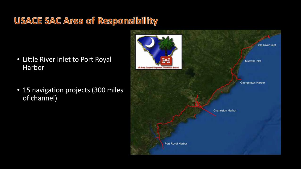
• Little River Inlet to Port Royal Harbor
• 15 navigation projects (300 miles of channel)


Singlebeam Sonar• Condition surveys and some shallow water
areas• Required accuracies see EM110-2-1003 3-1
**no uncertainty- collected with POS MV• “Original density” mosaics

Dredge Contract Hog Island Reach
Charleston Harbor
Offshore object investigation multispectral backscatter/bathymetry
Multibeam sonar• Full coverage 3x3ft mosaics• Mainly used to compute dredge volumes• 170-700 kHz range but contracts in 400kHz or
200kHzBefore Dredge After Dredge
*backscatter snippet data is collected as .R2S using Hypack for every survey (not always processed)
*some multifrequency data available and some multispectral backscatter datasets available (have been used for object detection and identification on special occasions)
Submerged dredge pipe in multispectral backscatter

*Multispectral backscatterERDC Research and Technical Report

Side Scan Sonar• Object investigations
(rare)• Klein 5000
Magnetometer• Archaeological studies (for
channel realignment