in gratitude for your support of the arizona-sonora … · in gratitude for your support of the...
TRANSCRIPT

In g ra t i tude f o r your suppor t o f the Ar izona-Sonora Deser t MuseumIn gratitude for your support of the Arizona-Sonora Desert Museum
Sonorensis | winter 2013 1
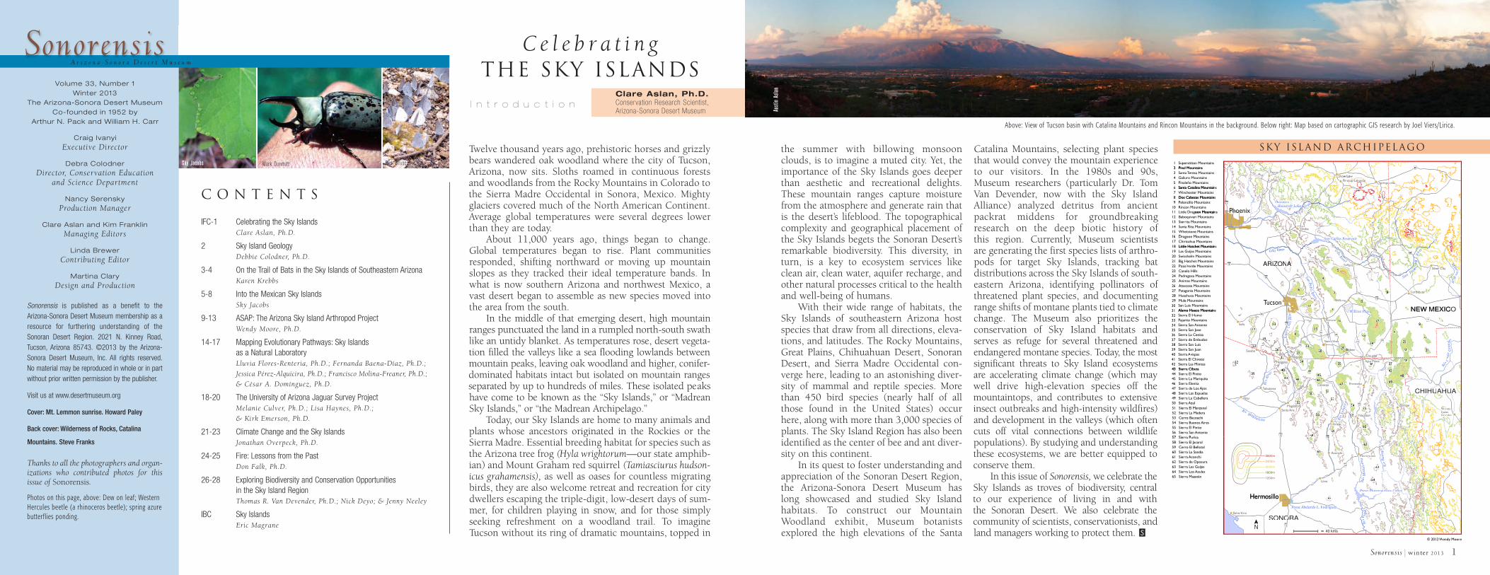
the summer with billowing monsoonclouds, is to imagine a muted city. Yet, theimportance of the Sky Islands goes deeperthan aesthetic and recreational delights.These mountain ranges capture moisturefrom the atmosphere and generate rain thatis the desert’s lifeblood. The topographicalcomplexity and geographical placement ofthe Sky Islands begets the Sonoran Desert’sremarkable biodiversity. This diversity, inturn, is a key to ecosystem services likeclean air, clean water, aquifer recharge, andother natural processes critical to the healthand well-being of humans.
With their wide range of habitats, theSky Islands of southeastern Arizona hostspecies that draw from all directions, eleva-tions, and latitudes. The Rocky Mountains,Great Plains, Chihuahuan Desert, SonoranDesert, and Sierra Madre Occidental con-verge here, leading to an astonishing diver-sity of mammal and reptile species. Morethan 450 bird species (nearly half of allthose found in the United States) occurhere, along with more than 3,000 species ofplants. The Sky Island Region has also beenidentified as the center of bee and ant diver-sity on this continent.
In its quest to foster understanding andappreciation of the Sonoran Desert Region,the Arizona-Sonora Desert Museum haslong showcased and studied Sky Islandhabitats. To construct our MountainWoodland exhibit, Museum botanistsexplored the high elevations of the Santa
Catalina Mountains, selecting plant speciesthat would convey the mountain experienceto our visitors. In the 1980s and 90s,Museum researchers (particularly Dr. TomVan Devender, now with the Sky IslandAlliance) analyzed detritus from ancientpackrat middens for groundbreakingresearch on the deep biotic history of this region. Currently, Museum scientists are generating the first species lists of arthro-pods for target Sky Islands, tracking bat distributions across the Sky Islands of south-eastern Arizona, identifying pollinators ofthreatened plant species, and documentingrange shifts of montane plants tied to climatechange. The Museum also prioritizes theconservation of Sky Island habitats andserves as refuge for several threatened andendangered montane species. Today, the mostsignificant threats to Sky Island ecosystemsare accelerating climate change (which maywell drive high-elevation species off themountaintops, and contributes to extensiveinsect outbreaks and high-intensity wildfires)and development in the valleys (which oftencuts off vital connections between wildlifepopulations). By studying and understandingthese ecosystems, we are better equipped toconserve them.
In this issue of Sonorensis, we celebrate theSky Islands as troves of biodiversity, central to our experience of living in and with the Sonoran Desert. We also celebrate thecommunity of scientists, conservationists, andland managers working to protect them.
Twelve thousand years ago, prehistoric horses and grizzlybears wandered oak woodland where the city of Tucson,Arizona, now sits. Sloths roamed in continuous forestsand woodlands from the Rocky Mountains in Colorado tothe Sierra Madre Occidental in Sonora, Mexico. Mightyglaciers covered much of the North American Continent.Average global temperatures were several degrees lowerthan they are today.
About 11,000 years ago, things began to change.Global temperatures began to rise. Plant communitiesresponded, shifting northward or moving up mountainslopes as they tracked their ideal temperature bands. Inwhat is now southern Arizona and northwest Mexico, avast desert began to assemble as new species moved intothe area from the south.
In the middle of that emerging desert, high mountainranges punctuated the land in a rumpled north-south swathlike an untidy blanket. As temperatures rose, desert vegeta-tion filled the valleys like a sea flooding lowlands betweenmountain peaks, leaving oak woodland and higher, conifer-dominated habitats intact but isolated on mountain rangesseparated by up to hundreds of miles. These isolated peakshave come to be known as the “Sky Islands,” or “MadreanSky Islands,” or “the Madrean Archipelago.”
Today, our Sky Islands are home to many animals andplants whose ancestors originated in the Rockies or theSierra Madre. Essential breeding habitat for species such asthe Arizona tree frog (Hyla wrightorum—our state amphib-ian) and Mount Graham red squirrel (Tamiasciurus hudson-icus grahamensis), as well as oases for countless migratingbirds, they are also welcome retreat and recreation for citydwellers escaping the triple-digit, low-desert days of sum-mer, for children playing in snow, and for those simplyseeking refreshment on a woodland trail. To imagineTucson without its ring of dramatic mountains, topped in S
I n t r o d u c t i o n
C o n t e n t s
Clare Aslan, Ph.D.Conservation Research Scientist, Arizona-Sonora Desert Museum
Volume 33, Number 1Winter 2013
The Arizona-Sonora Desert MuseumCo-founded in 1952 by
Arthur N. Pack and Will iam H. Carr
Craig IvanyiExecutive Director
Debra ColodnerDirector, Conservation Education
and Science Department
Nancy SerenskyProduction Manager
Clare Aslan and Kim FranklinManaging Editors
Linda BrewerContributing Editor
Martina ClaryDesign and Production
Sonorensis is published as a benefit to theArizona-Sonora Desert Museum membership as aresource for furthering understanding of theSonoran Desert Region. 2021 N. Kinney Road,Tucson, Arizona 85743. ©2013 by the Arizona-Sonora Desert Museum, Inc. All rights reserved. No material may be reproduced in whole or in partwithout prior written permission by the publisher.
Visit us at www.desertmuseum.org
Cover: Mt. Lemmon sunrise. Howard Paley
Back cover: Wilderness of Rocks, Catalina
Mountains. Steve Franks
Thanks to all the photographers and organ-izations who contributed photos for thisissue of Sonorensis.
Photos on this page, above: Dew on leaf; WesternHercules beetle (a rhinoceros beetle); spring azurebutterflies ponding.
SonorensisA r i z o n a - S o n o r a D e s e r t M u s e u m
IFC-1 Celebrating the Sky Islands Clare Aslan, Ph.D.
2 Sky Island Geology Debbie Colodner, Ph.D.
3-4 On the Trail of Bats in the Sky Islands of Southeastern Arizona Karen Krebbs
5-8 Into the Mexican Sky IslandsSky Jacobs
9-13 ASAP: The Arizona Sky Island Arthropod ProjectWendy Moore, Ph.D.
14-17 Mapping Evolutionary Pathways: Sky Islands as a Natural LaboratoryLluvia Flores-Renteria, Ph.D.; Fernanda Baena-Díaz, Ph.D.;
Jessica Pérez-Alquicira, Ph.D.; Francisco Molina-Freaner, Ph.D.;
& César A. Domínguez, Ph.D.
18-20 The University of Arizona Jaguar Survey ProjectMelanie Culver, Ph.D.; Lisa Haynes, Ph.D.;
& Kirk Emerson, Ph.D.
21-23 Climate Change and the Sky Islands Jonathan Overpeck, Ph.D.
24-25 Fire: Lessons from the PastDon Falk, Ph.D.
26-28 Exploring Biodiversity and Conservation Opportunities in the Sky Island RegionThomas R. Van Devender, Ph.D.; Nick Deyo; & Jenny Neeley
IBC Sky IslandsEric Magrane
Above: View of Tucson basin with Catalina Mountains and Rincon Mountains in the background. Below right: Map based on cartographic GIS research by Joel Viers/Lirica.
Mark DimmittSky Jacobs Rick Brusca
C e l e b r a t i n gthe sky islands
12 Pinal Mountains
Superstition Mountains
60
J
60
111213141516
oon MountainsLittle DragBaboquivari Mountains
rita MountainsSierSanta Rita MountainsWhetstone Mountains
oon MountainsDrag
9
2345678
10
Mountainsesa erSanta T Tero MountainsGaliuro
Pinaleño MountainsSanta Catalina MountainsWinchester MountainsDos Cabezas Mountainseloncillo MountainsP
Rincon Mountains
Pinal Mountains
Pay o
o
ysony
R RPhoenixh
on
R RTheodoreTheodore177
y nPaPaaysonayson
1
oon Mountains
Santa Catalina Mountains
Dos Cabezas Mountains
Phoenix
22
se lt Lake rvelt Lakeevelt Lake
22
e
Rido
v
etop-Lak
oosevelt Lake i rre
R
etop-Lak
ri eererereervviRiiiiviviviRRRRivRivRtltS
t RlltltlaaalalaSSSaaS
dorereodore
60
w LoShoPinetop-Lak
Globe2
villed
villeesided
eSpringer
191
rSpringerp g
ww Loidetop-Laktop-LakLp L k
212223242526272829
Big Hatchet MountainsMountainsde erozo V VerP
Canelo Hillsosa MountainsegedrP
Animas MountainsAtascosa Mountains
onia MountainsPatagHuachuca MountainsMule Mountains
1617181920
oon MountainsDragChiricahua MountainsLittle Hatchet MountainsLas Guijas MountainsSwisshelm Mountains
Ri
ucsonTTucson
viivRaliG
IZRIZONZ8
10
ARIZON
Little Hatchet Mountains
33
55
dr
33
AA
Carlos R
55
WW
66
rlos R
33
66
WW
55
44
6677
66
eservoir Carlos R l
reerviiv
RRior
deP
naanSSa
rev
reervve
Riiiv
RRiv
alla
Giiil
GGil
San Carlos RSan Carlos R Carlos R Carlos R
77
70
Safffo
xWillco
444
ANON3
4
7777
44
76
5
44
33
8888
rvoirrvoir
c
a
99
88
ervoir
ocssiin
cnaan
rrFnaanS
10
191
808011
Lor
dor
88
9
8
vc
dsb rg
i
City
r
m
r
R
rreeererevveiiiviviRRRiRocssiicc
n
reerv iv iiv
RRi RRissees
rbmmbiimiim
MMMi
r Cityer City e CitySilv
dsburg
36373839404142
ra La CenizaSierra de EmbudosSierra San LuisSier
uanra San JSiervispasra A AvispasSier
ra El ChivatoSierra Las MinitasSier
303132333435
San Luis MountainsAlamo Hueco Mountains
ra El HumoSierPajarito Mountains
San Antoniora Sierosera San JSier
43 ra CibutaSier
22
99
2222
3232
22
99
33
2626
332222
66
ucsonTTucson
oo3
86
Nogales
Sells
Sasabe
Nogales
19
22
22
123313
22222626266
322333
4040
33
662
322
Alamo Hueco Mountains
2323
55
33
3535
292928282828
3434
4040
Benson
n
oN
22
0000
55
6666
4444
BB22
alesa es
353555
22
ales434
00
66
5544
222828
NogalesN ll
Benson
r
a Vista
NogalesNogales3
reviR
zurruCCrattanaanaanSS
3
ta
N
ra Vistaa Vista t
19
90
82
80
ra VistaSierSier
galesg27272727
Bisbee2929
nson
0010
1415
6616
11
22233
22
3434
227882828
9229
33333333
27
344 35
400
5534333
922
33
0
3030
2020
22 2525
383838383636 3737
i
a a
99
3737
88
2020
44
ya
99
442244
77
20202525
77
22
88
W layaillcox Playa ya yW Playaillcox PlayaW
77
2424
W
80191
3636
asDouglas
Bisbee
NEW MEXIC
2424
17
8
2020220
24242424 255
30
Agua Prieta36 37
38
242
9
7
8 66
0
00
88
33
esdeas
88
222222 sedna rG
sasaCC
aoííoRRí
2
9
ONEW MEXIC
331
22221
18888
3
222
4344454647484950
ra CibutaSierra El PinitoSierra La MariquitaSierra ElenitaSier
Ajosra de Los Sierra Las EspuelasSier
ra AzulSierra La CabelleraSier
51525354555657
ra El ManzanalSierra La MaderaSiero BacoachirCer
esBuenos Airra Sierra El PinitoSier
San Antoniora Sierra PuricaSier
393933
anelleaaldda
ggdaagMMaoííoRRí
raarttalltAAloííoR
AAltarA
15
Altar
ubutamaTTubutama
399444
9
4343
55
5656
4545
5959
4040
5353
58585959
nalena
pA i e
99
no
r
4444
4343
CCananea
44444444nea
55
774747
50505050
5525252
5656
444444
4444 46464747
55
66
ao
ArizpeA
Cananea
55
dalenanalena
n
rroonnoonoSo
SoSooííoRRíR
44
A p
55955
Santa AnaMagdalena
4441
5551
4040
43434343 44444455
4646455446
47
00500
525252253
5656566
58599
4
958
666
32
00
77
555443
0
4949
4848
55 cozari
ras
B
4848
55555555545444
7777
60606060
99
ispe
994949
54545555
606000
acozario
vispei p
C
17
Nacozari
pBaBavispeB
onterasFr
C
42424242
4949
44488
4454
575757
60606060
555555
4442222
55
00
8
A
randes
ue
Grandes
H HUH A
2
esasasCasas
N evasNue
AHUUHIHUC
65646362616059
5758
o El BellotalrCerra La SandiaSier
ra PuricaSierra El JacaralSier
ra de OposuraSierra AconchiSier
ra Las GuijasSierLos Azulesra Sier
ra MazatánSier
HermosilloHermosillo
600m1
2000m
400m2
2800m
200m1
onchi
6565
66
5
Aconchi
14
118
Aconchi
esUr
6661
85858
656565555
6
6363
226262
Rí
6262
6363
e
umaezuma
6464
Plutarco Elias Calles al Elias Calles alles
62626262
tezuma
Elias Calles
e p
o Elias Calles
ípppss iiis is i vv
aa Boíío
RRí
amuum zetc o
MoííoR
M
Presa Plutarco Elias Calles
Moctezuma
622
6363
646466464646464
666
2
SONORABahía Kino
SONORAN
iguezzPresa Abelardo L. R
O
r P odrigueziPresa Abelardo L. R
NORAO
odriguezresa Abelardo L. RP Abelardo L. R
15
NORA
40 kms
R
uY
i uuiqqaYYaoíío RRí
eendy MoorWWendy Moor© 2012
Sky Island Archipelago
Austi
n As
lan

2 Sonorensis | winter 2013
On the timescale of mere mortals, geology is the stage on whichthe drama of life unfolds. But speed up time, and geology takescenter stage as mind-boggling forces shape the Earth like putty.About 70 million years ago, the Sky Island Region was part ofa great rising mountain range, as the western edge of NorthAmerica crumpled, cracked, and folded under pressure from acollision with a crustal plate to the west. Then, in a huge plotreversal, the pressure was suddenly off, and the region startedto stretch, heated by geological processes below. From 25 to 12million years ago this land was pulled slowly apart like taffy,creating much of our topography. The final bit of stretching,from 12 to 4 million years ago, cracked the crust, forming themountains and valleys we see today. These events shaped thebroad region known as the Basin and Range Geologic Province,which stretches from northern Mexico all the way to southernOregon and Idaho. The Sky Islands were formed in the south-ern part of the province, between the Rocky Mountains to thenorth and the Sierra Madre Occidental to the south, in a vastgap between those higher-elevation ranges.
The mountains of the Sky Islands rise thousands of feetabove the low valley floors, punching into layers of atmos-phere that are cooler and wetter. As winds force air up andover these mountains, water vapor condenses, forming clouds,and when we are lucky, rain. Thus, the mountains help pullwater from the air and bring it back to the landscape, where it nourishes life in the Sky Islands and the valleys below, and seeps into aquifers that supply riparian areas as well as amultitude of human needs.
G e o l o g yDebbie Colodner, Ph.D.
Director, Conservation Education and Science,Arizona-Sonora Desert Museum
Chip
Hedg
cock
Left: Sierra Bacadéhuachi
S
Sonorensis | winter 2013 3
As we sit quietly beside a stream in the GaliuroMountains, a scream shatters the cool evening andbounces off the canyon walls. My assistant turns tome. “Do we have anything to worry
about?” I smile and answer,“It’s just an angry mountain
lion and will probably move on,” as Istrain my eyes to locate the animal,
which sounds very close. After all, we hadset a net over a large pool of water to capture bats,and the big cat is probably thirsty.
I often think about the mountains lions, blackbears, skunks, snakes, Gila monsters, owls, deer,and other wildlife that have contributed to theexcitement of my field research in the Sky Islandsthese last fifteen years. There was a time in thePinaleño Mountains, when I woke up in the middleof the night to find a skunk had placed its front legson my cot just inches from my face! On anotheroccasion, a skunk jumped up on my cot and land-ed on my chest as I was sleeping. I slowly put myhead back down and went back to sleep; I didn’twant to make any sudden movements. But there isnothing that will get your heart pounding fasterthan a rattlesnake that settles under your old, tornlawn chair. The snake under my chair definitely was-n’t there when I set it up!
Through the years, I have utilized mist nets,acoustic recording equipment, video cameras, andinfrared lights to capture and detect bats along
streams, trails, meadows, washes, hilltops, and incaves and mines. My fieldwork has produced dataon more than 3,500 bats representing 30 species inArizona and Mexico, and information on 2,800 ofthose bats (22 species) comes from the mountains ofsoutheastern Arizona. All of these field data—including measurements for forearms, fingers,thumbs, ears, feet, and weight—are provided to stateand federal partners such as Arizona Game and FishDepartment, U.S. Fish and Wildlife Service, and theNational Park Service, and the data have producedvaluable information about the migration, move-ments, and reproduction of wild bats, as well as theirresponses to weather extremes, their general health,and information specific to local populations.
Years of annual fieldwork in the ChiricahuaMountains have provided important data on thearrival times of migratory bats. We have learned thatsilver-haired bats (Lasionycteris noctivagans) do notarrive at the same time each year. In fact, we suspectthat some individuals may actually be year-roundresidents of the mountains in this area, since I havecaptured this species repeatedly in both summerand winter in the Chiricahuas. But far more silver-haired bats are captured during the summer monthsthan in the winter, suggesting both resident andmigratory behaviors. Typically, this species is cap-tured between three and four hours after sunset, butfor the past several years I have observed this batforaging during daylight hours, another exciting
O n t h e Tr a i l o f B a t sin the sky Islands ofSoutheastern Arizona Karen Krebbs
Conservation Biologist
Top above: Karen Krebbs using telemetry antennas to detect bats.Cut out left: Allen’s lappet-browed bat (Idionycteris phyllotis).
Above: Townsend’s big-eared bat (Corynorhinus townsendii).
Bruce Taubert
Bruc
e Ta
uber
tCo
urte
sy o
f Kar
en K
rebb
s.

and unexpected discovery, since bats are more vul-nerable to predators during daylight hours.
In twilight and dark hours, owls may be the mostcommon predator of bats as they forage. Bat bones are com-monly found in owl pellets, and I have captured owls and batssimultaneously in my nets—a fair indication that the owl waschasing the bat when they were captured. Some owl speciesroost in the very same caves and mines as many bat species. Atone of my study sites in the Chiricahuas, a Mexican spotted owl(Strix occidentalis lucida) shows up regularly to watch us capture,process, and release bats, but this owl has never chased any ofthe bats we have processed; it just sits quietly and watches.Although bats are generally considered prey for this species, thisindividual appears to be more interested in watching us capturebats than in catching one itself.
Winter batsMost bat research is carried out during the summer months, butwinter work is just as rewarding, and has provided importantdata on bat behavior in cold temperatures. My winter work inthe Chiricahuas has revealed that not only silver-haired bats, butmany species of bats remain active throughout the winter, and,although some individuals of these species may disappear dur-
ing periods of extreme cold temperatures, they reemerge whenweather conditions improve. During cold winter evenings,
I have used a bat detector to record feeding buzzes (short,rapid, high-pitched ultrasonic pulses emitted by echolo-cating bats during the final stages of capturing prey).These recordings demonstrate that the bats are active-ly hunting during the winter (which leads me to won-
der about the insects that must also be active in these cold tem-peratures). One evening I captured a female pallid bat (Antrozouspallidus) that was active while the temperature was only 24°Fahrenheit! But add wind and moisture to the weather equation,and the bats will opt not to come out!
One cold November evening, I captured two males, aTownsend’s big-eared bat (Corynorhinus townsendii) and anAllen’s lappet-browed bat (Idionycteris phyllotis), at the sametime in the same net pocket. We processed the bats and releasedboth at the same time; they flew off in the same direction. Thiswas only the sixth time I had captured an Allen’s lappet-browedbat in 14 years of fieldwork, and I had never captured thisspecies together with another species, which led me to wonderabout the possible reasons these bats were flying together thatevening. Although extending fieldwork into the winter monthshas revealed exciting new information about the behavior ofinsectivorous bats, it has also generated many new questionsthat remain to be answered.
Following the trail of bats in 12 different Sky Islands hasbeen extremely rewarding. I eagerly look forward to each andevery field day, and I am still hopeful that during one of my fieldresearch trips, I will spot an elusive jaguar watching me workalong some mountain stream!
Suggested Reading
Kunz, Thomas H. 2010. Field Guide to the Bats of NorthAmerica. Oxford University Press, USA.
Sonorensis: Celebrating Bats. 2011. Arizona-Sonora DesertMuseum, Tucson, AZ.
S
4 Sonorensis | winter 2013
Above: Mexican spotted owl (Strix occidentalis lucida).Below: Hooded skunk (Mephitis macroura).Cut out right: Silver-haired bat (Lasionycteris noctivagans).
Bill Hornbaker
Kare
n Kr
ebbs
Bruc
e Ta
uber
t
A monsoon storm drenches a brown-backed solitaire on the east slope of a high sierra. Amountain creek trickles softly over worn rocks. A land snail slides across moist leaf litter on
a forest floor. Countless moments of nature’s poetry go unsung every minute of everyday in the remote parts of the Madrean Sky Islands.
Within the United States, the Madrean Sky Islands are largely public lands that experience frequent visitation from recreationists and
biologists. In Sonora, however, they are seldom-visited wildlands.Because of their remoteness, a tendency for Mexican biologists to
work more often in central and southern Mexico, and an arbitrarypolitical boundary bisecting this amazing and diverse region, few
biologists have ventured into the southern Sky Islands. Fewpeople enter the highlands of the Mexican Sky Islands for any
reason; even the vaqueros common in remote parts of low-land Sonora are seen only rarely in these mountains. The
costs of constructing and maintaining infrastructure forcattle in this rugged, remote terrain are generally pro-
hibitive for ranching, as they are for extracting mostnatural resources.
Sky JacobsWatershed Management Group
I n t o t h e Mexican Sky Islands
Elegant Trogon (Trogon elegans).
Sky Jacobs
Sonorensis | winter 2013 5

6 Sonorensis | winter 2013
Through the centuries, and even now,these more remote Sky Islands have large-ly been left alone, with one significantexception. Logging took a serious toll onwildlife and habitat between the 1930sand 1950s, when stands of old-growthpine forest were decimated in the largerranges. More than a half-century laterthese forests are still recovering. Mostpine forests are not yet mature enough tomake logging cost-effective, and commer-cial logging is now rare. In the adjacentSierra Madre, where pine forests areextensive and access is easier, large-scalelogging continues, and little old-growthforest remains.The full impact of commercial logging
is unknown, but it likely had broad nega-tive effects on a diverse range of wildlife.The imperial woodpecker, for example,once the largest woodpecker on Earth andendemic to the Sierra Madre Occidental(and likely the larger southern SkyIslands), has been declared extinct.Populations of thick-billed parrot, whichwere once abundant, have declined, withflocks now restricted to a limited numberof localities in the higher parts of theSierra Madre Occidental. However, it isdifficult to say what effects logging had on
the distribution and abundance of birdsand other wildlife in the southern SkyIslands and nearby Sierra Madre, becausebaseline data from before the mid-twenti-eth century is sparse. Very few biologistshad explored the Mexican Sky Islandsbefore logging began.In the 1950s, however, one biologist
traveled to many places that few had seen.Ornithologist and explorer Joe Marshall,Jr., worked throughout the Sky Islands onboth sides of the U.S.-Mexico borderstudying birds and their oak and pine-oakwoodland habitats. In 1957 Marshall pub-lished Birds of Pine-Oak Woodland inSouthern Arizona and Adjacent Mexico, acomprehensive and often poetic accountof bird distribution, abundance, habitatuse, and biogeography in the MadreanSky Island Region and neighboring SierraMadre Occidental. Marshall’s work pro-vided an important baseline on the distri-bution and abundance of birds in theregion, including in 9 Sky Islands inSonora. The late Peter Warshall, whoauthored The Madrean Sky IslandArchipelago: A Planetary Overview, aninsightful presentation on the biogeogra-phy of the Madrean Sky Islands said ofMarshall’s work, “Never surpassed, thiselegant monograph described the stackingof biotic communities on each islandmountain from the Mogollon Rim to theSierra Madre.”Since 2000, Aaron Flesch and his
associates have followed in Marshall’s
Sonorensis | winter 2013 7
footsteps, visiting little-known land-scapes of the Sky Islands in Mexico.Flesch’s main goal since 2008 has been todescribe the patterns of bird distributionsacross the region, but he and his fieldcrews have also collected important dataon other animal and plant groups. As aparticipant in several of his field expedi-tions, I can attest to the multiplicity ofchallenges that characterize field work inthis remote, rugged, and fascinatingregion. We traversed untold miles of ter-rible roads, backpacked and mule-packedthrough remote and steep terrain, and braved thunderstorms, lighting, and other dangers. (Although oftenoverblown in the media, these dangers doinclude regular encounters with illicitdrug growers and smugglers.) Regardless,most people in the region are very friendly,helpful, and interested in wildlife, and locallandowners deserve special recognitionfor generously granting access to theirland and always lending a hand.Supported by the National Park
Service and Desert Southwest Coopera-tive Ecosystem Studies Unit, as well asthe Mexican Park Service (CONANP),Flesch and his associates have collecteddata in almost every Madrean Sky Islandsouth of the U.S.-Mexico border since2008. He has been very fortunate tohave the help of young Mexican biolo-gists, especially Carlos Gonzalez andJavier Amarillas. Thus far, they have sur-veyed birds and measured habitat in 26
Sky Islands in Sonora and 7 areas in theadjacent Sierra Madre, covering an areamuch broader than that visited byMarshall. Fieldwork for this projectended in 2012, and research reports arenow in preparation. Many of Flesch’sobservations have been submitted to thepublicly accessible MABA database atwww.madrean.org. Flesch has documented several new
breeding bird species in the Sonoran SkyIslands, including short-tailed hawk,brown-backed solitaire, crescent-chestedwarbler, and slate-throated redstart, aswell as other notable likely breederssuch as the white-striped woodcreeperand flame-colored tanager. He has alsoobserved northern species at theextreme southern end of their ranges,such as the first breeding western tan-agers and hermit thrushes in mainlandMexico. Beyond these notable records,extensive distance sampling at over1,500 points has enabled him to esti-mate the densities of more than 60species of breeding birds in each SkyIsland he has surveyed.Due to the limited fieldwork carried
out in the southern Sky Islands, observa-tions of even common plants and ani-
Above: Sierra El Tigre.Left: Hermit thrush (Catharus guttatus).
Above: Sierra Azul.Right: Rufous-capped warbler (Basileuterus rufifrons).
Step
hen
Min
ter
Sky
Jaco
bs
Step
hen
Min
ter
Sky
Jaco
bs

8 Sonorensis | winter 2013
mals are often noteworthy. Thus, whenpossible, Flesch has photographed andcataloged mammals, herpetofauna, andplants, which has resulted in manyobservations of species outside their pre-viously known ranges. Flesch has col-lected the first Sonoran records ofspecies such as Rhamnus californica, R.ilicifolia (coffeeberry and hollyleaf red-berry, respectively—both buckthorns),and Dalea tentaculoides (Gentry’sindigobush). Other notable observationsinclude the northernmost observationand only the second record for the SkyIslands of Pinus yecorensis (Yecora pine),near Nacozari de Garcia; the northern-most and first Sky Island record forQuercus durifolia (roble prieto/dark oak),in the Sierra el Tigre; and the western-most observation and first Sky Islandrecord of Ilex rubra (a holly), in theSierra Opusera. Flesch has also docu-mented many formerly unrecorded pop-ulations of species that are common inthe northern Sky Islands but rare in thesouth; examples include Populus tremu-loides (quaking aspen) and Quercus gam-belii (Gambel oak).
Flesch’s fieldwork is making a land-mark contribution to our understandingof the natural history and diversity of theregion. In addition, th is and other fieldprojects are bringing researchers, institu-tions, land managers, and landownerscloser together. Documenting the biodi-versity of the Sky Island Region, includ-ing that of the many ranges south of theborder, will help us better understandand therefore better protect the speciesthat live here for the benefit of futuregenerations.
Suggested ReadingFlesch, A. D., and L. A. Hahn. 2005.“Distribution of Birds and Plants at theWestern and Southern Edges of theMadrean Sky Islands in Sonora, Mexico.”In Connecting Mountain Islands and DesertSeas: Biodiversity and Management of theMadrean Archipelago II. Proc. RMRS-P-36Fort Collins, CO. U.S. Department ofAgriculture, Forest Service, RockyMountain Research Station.
Warshall, P. 1995. “The Madrean SkyIsland Archipelago: A PlanetaryOverview.” In Biodiversity andManagement of the Madrean Archipelago:The Sky Islands of Southwestern UnitedStates and Northwestern Mexico. GeneralTechnical Report RM-GTR-264. U.S.Forest Service. Tucson, AZ.
Sky
Jaco
bsSk
y Ja
cobs
Above: Dew on leaves, Sierra Huachinera. Below: Sharp-shinned hawk chicks (Accipiter striatus),Sierra el Tigre.
S
Sonorensis | winter 2013 9
Sky Islands andTerrestrial Arthropods
Southeastern Arizona’s Sky Islands have long fasci-nated naturalists because of the extraordinary biolog-ical diversity and the complex geographical distribu-tions of species found in these ranges. Because thesemountain “islands” are separated by “oceans” ofdesert or grassland, over time their montane popula-tions became more or less isolated from one another.Take a beetle that lives only in the highest biome(Mixed Conifer Forest) on Mount Lemmon; its clos-est relatives live in the Mixed Conifer Forest of otherSky Islands, such as the Pinaleños and Chiricahuas.Since these montane populations are restricted to dif-ferent mountaintops and separated from one another
by desert seas, they often evolve and adaptindependently, eventually becoming distinctenough to warrant separate species or sub-species status (a process biologists call “speciesdiversification”). And, because arthropods(insects, isopods, millipedes, mites, spiders, scor-pions, etc.) reproduce frequently and in larger num-bers, they can evolve into distinct populations at afaster pace than most larger animals. As an entomol-ogist, I knew the Sky Islands would be ideal forstudying the process of species diversification.
Ecologically, arthropods are critical. They drivekey ecosystem processes, such as pollination, litterdecomposition, nutrient recycling, and soil aera-tion, and are essential food for reptiles, birds, andsmall mammals. However, their life histories, popu-
Wendy Moore, Ph.D.Assistant Professor and
Curator of the University of Arizona Insect Collection,Department of Entomology,
University of Arizona
Mich
ele L
anan
Winter Ants (Prenolepis imparis) tending aphids.

Sonorensis | winter 2013 11
lation dynamics, survival strategies, value to society,and conservation status are still relatively poorlyknown. The enormous potential for researching thenatural history of arthropods in the unique naturallaboratories of the Sky Islands led to the founding ofthe Arizona Sky Island Arthropod Project (orASAP), in my lab in the University of Arizona’sDepartment of Entomology.
The ASAP project has undertaken the ambitiousjob of documenting the arthropod fauna, not just ofthe nearby Santa Catalina Mountains, but of all theSky Islands in southeastern Arizona. The panoramaof isolated vegetation types throughout this regionprovides us with perfect natural replications of habi-tat for ecological studies. Using these natural labo-ratories, we are investigating how arthropod com-munities have assembled within the Sky Island bio-mes and diversified among the isolated ranges. Thefundamental questions we are addressing include:
• Which arthropods inhabit Arizona’s Sky Islands,and how are these species distributed within theregion?
• What are the biogeographic affiliations of the SkyIsland arthropods?
• What are the evolutionary relationships of the SkyIsland arthropods? Which groups have radiatedwithin the Sky Island Region?
• What are the over-arching drivers that structurearthropod communities in the Sky Islands (e.g.moisture, temperature, soil type, plant associa-tions)?
• How might montane arthropod communitiesrespond to rapidly changing climate conditions?
We began our research on the ground in theSanta Catalinas—one of only three ranges north ofthe U.S.-Mexico border with the full sequence ofbiological communities found in the Sky IslandRegion—from desertscrub to subalpine fir forest[see diagram of biomes, page 17]. In early 2011,ASAP researchers established 66 sampling sites forarthropod collection along the elevation gradients ofthe range—along the Mt. Lemmon Highway on thesouth side of the Catalinas, and along the ControlRoad on the north side. In 2011 and 2012, theASAP team deployed pitfall traps at each site for twoweeks in May (pre-monsoon) and again for twoweeks in September (post-monsoon), capturing theground-dwelling arthropods that were active duringthose periods.Preserved specimens were brought tothe lab to be sorted and identified by members of the ASAP team. Data on thenumber of specimens of eachspecies collected by each trapare being carefully recorded, andthe specimens themselves arebeing deposited in the University ofArizona Insect Collection.
10 Sonorensis | winter 2013
As an entomologist, I knew the Sky Islands would be ideal
for studying the process of species diversification.
Because these mountain “islands” are separated by “oceans” of desert or grassland,
over time their montane populations became more or less isolated from one another.
Far left: Chiricahuas rising from the desert floor. Upper right: Pitfall trap.
Cut out: Bark-gnawing beetle (Temnoschelia chloradia). These brilliant metallicgreen beetles can be found on and under the bark of many types of trees,
where they feed on larvae of various bark-boring insects.Lower right: Carabid beetle collection.
Mic
hele
Lan
an
Wen
dy M
oore
Alex Wild
Wen
dy M
oore

Sonorensis | winter 2013 13
already evident (e.g., increased fire, pest out-breaks, spread of invasive species, etc.), and plantcommunities are under stress. Additional temper-ature increases of as little as a few degrees couldpush Sky Island plant and arthropod species toeven higher elevations, potentially causing localextinctions of endemic species and subspecies andother evolutionarily unique lineages.
ASAP OnwardThis past summer ASAP began collections in thePinaleños, Huachucas, and Chiricahuas. In thecoming years we will sample many other ranges,and we expect to be collecting data in the SkyIslands for another 30 years. As the ASAP projectgrows, new patterns in the deep history of the mon-tane arthropods of our region will emerge, modelspredicting how these animals will respond tochanging climates will be developed, and threat-ened species and populations will be identified.Information from ASAP will contribute to science-
informed public policy in environmental conserva-tion, as well as deepen our understanding of thesmall animals that help make this region so diverse.
ASAP Collaborators:Sandra Brantley, University of New Mexico; Rick Brusca, Arizona-Sonora Desert Museum(ASDM)/University of Arizona (UA); Jeff Eble, UA,; Kim Franklin, ASDM; Antonio Gomez, UA; Gene Hall, UA; Jeff Henkel, UA; Garrett Hughes, UA; Paul Marek, UA (now at Virginia Tech); Reilly McManus, UA; Marty Meyer, UA (now at Pomona College); John Palting, UA; Jason Schaller, UA; John Wiens, ASDM; Alan Yanahan, UA.
Suggested ReadingBrusca, Richard C., and Wendy Moore. 2013. A Natural History of the Santa Catalina Mountains, Arizona,
with an Introduction tothe Madrean Sky Islands.ASDM Press: Tucson, AZ.
Brusca, R. C., J. F. Wiens, W. M.Meyer, J. Eble, K. Franklin, J. T. Overpeck, and W.Moore. 2013. “Dramatic Response to ClimateChange in the Southwest: Robert Whittaker’s 1963Arizona Mountain Plant Transect Revisited.” Ecology& Evolution 3:3307-3319.
Moore, W., W. M. Meyer, J. A. Eble, K. Frankliln,J. F. Wiens, and R. C. Brusca. 2013.“Introduction to the Arizona Sky IslandArthropod Project (ASAP): Systemics,Biogeography, Ecology, and Population Geneticsof Arthropods of the Madrean Sky Islands.”In Merging Science and Management in a RapidlyChanging World: Biodiversity and Management ofthe Madrean Archipelego III. Proceedings RMRS-P-67, U.S. Forest Service, Rocky Mountain Research Station.
12 Sonorensis | winter 2013
Although all arthropod groups are understudy, ASAP has concentrated so far on two super-diverse groups: beetles (Coleoptera) and ants(Hymenoptera, family Formicidae). Ants are possi-bly the numerically dominant family of insects onEarth, representing 10–15 percent of the entireanimal biomass in terrestrial ecosystems. To date,nearly 100 ant species have been identified in theSanta Catalinas (with more samples remaining to be worked up). The most common are acrobatants (Crematogaster spp.), highway ants (Foreliusspp.), little black ants (Monomorium spp.), and big-headed ants (Pheidole spp.), while the mostscarce, to date, are small, cryptic species whosecolonies are smaller than those of most other ants(e.g. Hypoponera spp., Stenamma spp.).
Beetles comprise the most diverse group oforganisms, with approximately 370,000 describedspecies worldwide. Some beetle species are toparthropod predators, while other species feed onplants, decaying organic matter, or fungus, and thus
play important ecological roles in almost every ter-restrial habitat. To date, 197 species of ground-dwelling beetles have been collected and identifiedin ASAP’s surveys in the Catalinas. Initial analysesreveal a species distribution pattern in which specieswith temperate (northern) ancestral distributions aregenerally found at higher elevations, whileNeotropical (southern) species are generally found at lower elevations on the mountains. Among the largest and most noticeable are ground beetles(family Carabidae), darkling beetles (familyTenebrionidae), pleasing fungus beetles (familyErotylidae), longhorn beetles (family Cerambycidae),and scarab beetles (family Scarabaeidae).
Beyond ArthropodsIn 1963, ecologists Robert Whittaker and WilliamNiering systematically surveyed the plants alongthe Mt. Lemmon Highway, from desertscrub tosubalpine fir forest.In the ASAP project, we alsosurveyed plants at each of our 66 study sites in the
Catalinas, including the same 20-mile stretch sur-veyed by Whittaker and Neiring. Comparing theelevations of the 27 most common plant species inour survey with their historic data, we found thatalmost every species has shifted its lower eleva-tional boundary significantly upslope; in eightspecies, lower elevation limits have increased bymore than 800 feet, and some as much as 1000feet, including alligator juniper (Juniperus deppeanavar. deppeana), New Mexico groundsel (Packeraneomexicana), and meadow rue (Thalictrum fend-leri). The best hypothesis to explain these upwardshifts is that an increasingly warmer climate andthe ongoing persistent drought in southernArizona are driving species up the mountain, aspredicted by climate models for the Southwest (seeClimate Change and the Sky Islands, this issue).Here in Tucson, temperatures have increased at amean rate of 0.25°C per decade since 1949. In theCatalinas, as in all the Sky Islands, other effects ofwarming climate and prolonged drought are
S
Above left: Beyer’s scarab (Chrysina beyeri), one of three jewel scarab species found in Arizona. Taken in Madera Canyon, Santa Ritas. Middle: Purple pleasing fungus beetle (Gibbifer californicus), upper left inphoto, and larvae. Right: Big-headed ants (Pheidole rhea) found in Molina Basin, Santa Catalinas.
Mic
hele
Lan
an
Rick
Bru
sca
Alex
Wild
Rick
Bru
sca
Jeff
Eble
Above left: Santa Ritas. Right: Field work in desert grassland habitat on Mt. Lemmon. Cut out right: Snail-eating bettle (Scaphinotus petersi). This attractive ground beetle has evolved specialized elongate mouthparts for attacking snails in their shells. Whereas adults are specialized for eating snails, the larvae are predatory generalists, feeding on various small insects.
Alex Wild
New

Sonorensis | winter 2013 15
of the same species. To this end, we have been studying two species in the Sky Islands: alpine wood sorrel (Oxalisalpina), a small herbaceous angiosperm (or flowering plant)pollinated by insects, and border pinyon pine (Pinus discolor),a gymnosperm (or cone-bearing plant) pollinated by wind.
The research: alpine wood sorrel Oxalis alpina uses one of the most complex and rare repro-ductive systems in the plant kingdom. Within a single pop-ulation you may find two or three different flower types. In populations with two flower types, some plants have longstyles (female parts) that rise above the shorter stamens(male parts), while other plants have flowers with shortstyles and long stamens. A population consisting of two different flower types is called distylous. Other populationsare tristylous, having flowers with long or short styles, asdescribed above, as well as flowers with styles of intermediatelength between two sets of stamens.
In order to understand why some populations are distylous and others tristylous, we first asked if ecological con-ditions differed on the mountains with these populations. Oneimportant driver of change in plants is their relationship withpollinators, and we suspected that each Sky Island might have adifferent suite of pollinator species, which could be responsiblefor the variation in floral types. Surprisingly, we did not find dif-ferences in the pollinators among populations of O. alpina. Thecommon pollinators are two small bees in the genus Heterosarus,neither of which displays a preference for one flower type over
another, suggesting that pollinators are not the cause ofthe variation in the reproductive system of this species.
Still looking for an answer, we turned to a secondapproach using genetic markers (DNA sequences) toreconstruct the history of these populations. We foundthat populations of O. alpina in northern ranges have lessgenetic diversity than southern populations and a lower frequency of flowers with mid-length styles. This suggeststhat since the last glaciation, O. alpina has migrated tonorthern Sky Island ranges, and that random colonizationevents may partially explain the reduction in the frequencyof flowers with mid-length styles.
Further investigation revealed that another reason for the shift to distyly relates to the loss of what is known as a “het-eromorphic incompatibility system” in O. alpina. This system prevents fertilization between individuals of the same floral typeand allows fertilization to occur only when pollen from stamensof a certain length reaches styles of the same length. This meansthat crosses are only possible between individuals of differentfloral types. This system results in populations with roughlyequal proportions of the three flower types. However, we foundthat in northern populations of O. alpina, flowers with long andshort styles have lost this incompatibility system as a result of agenetic mutation. Therefore short- and long-styled flowers areable to cross-pollinate, while flowers with mid-length styles arenot. With the loss of the incompatibility system, flowers withshort and long styles could fertilize each other more, thus out-competing flowers with mid-length styles, which would explain
For us, the Sky Islands are a constant source of wonderand amazement; sometimes, we feel like we are walkingin the clouds. And the more we know about the wealth of
biodiversity here, the more we are amazed. Over the lasttwelve years at the Instituto de Ecología of the UniversidadNacional Autónoma de México, we have been studying two distinct species that live in the Madrean Sky Islands of the southwestern United States and northern Mexico. Theseisolated mountain ranges rising from an arid sea make up a“stepping stone archipelago” between two long and widechains of mountains—the Rocky Mountains and the SierraMadre Occidental. In the great low-elevation gap betweenthem, on mountains with woodlands or forests, species fromboth the southern and the northern ranges grow together.
If you explore a Madrean Sky Island, you will notice agradual change in vegetation as elevation increases (see figure,pg 17), from desertscrub at the lowest elevations throughdesert grasslands, oak grasslands, oak woodlands and chapar-ral, and, in the taller ranges, pine-oak woodlands and pineforests dominated by Arizona and ponderosa pines, and,eventually, mixed conifer forests with pine, fir, and spruce.Although some species show little genetic variation betweenmountain ranges, other species have evolved and radiated onthese “islands,” which serve as natural laboratories for thestudy of evolution because conditions differ from island toisland (as in the case of Darwin's finches in the Galapagos).
Our team is exploring the tremendous variation in plantreproduction systems across different mountain populations
14 Sonorensis | winter 2013
Lluvia Flores-Rentería, Ph.D.,
Postdoctoral Researcher, Biological Sciences,
Northern Arizona University
Fernanda Baena-Díaz, Ph.D.,
Instituto de Ecología,
Universidad Nacional Autónoma de México
Jessica Pérez-Alquicira, Ph.D.,
Postdoctoral Researcher, Ohio Agricultural Research
and Development Center, Ohio State University
Francisco Molina-Freaner, Ph.D.,
Ecologia de la Biodiversidad, Instituto de Ecología,
Universidad Nacional Autónoma de México
César A. Domínguez, Ph.D.,
Ecologia Evolutiva, Instituto de Ecología,
Universidad Nacional Autónoma de México
M a p p i n g e v o l u t i o n a r y p a t h w a y s :s k y i s l a n d s a s a n a t u r a l l a b o r a t o r y
Two morph populations (Distylous)
Three morph populations (Tristylous)
Mag
gie
Mill
inov
itch
Fran
k Ro
se
Above: Alpine wood sorrel flower (Oxalis alpina).
Sonoran Desert Region Map
Above: Border pinyon pollen cones (Pinus discolor).
Short Mid Long
Short Long
styleFemale parts(pistils)
Male parts(stamens)
Diag
ram
by S
teph
en G
. Well
er.

Sonorensis | winter 2013 17
and from this we can surmise that the species has changedlittle since becoming confined to isolated Sky Island habi-tats 10,000 to 12,000 years ago.
Wind pollination is one explanation for close geneticconnections across the Sky Islands, but it is not the only waygenes can be dispersed. Seeds also play an important rolein dispersal; however, as pine nuts are heavy and wingless, they depend on small mammals and birds, particularly jays, for dispersal. Pinyon jays may travel over 20 kilometers(but typically less than 5 kilometers) to cache pinyon nuts, and small mammals disperse seeds even shorter distances.Therefore we do not think that animals often move borderpinyon pine seeds between mountain ranges.
By combining both ecological and genetic approaches, we have been able to unravel the evolutionary histories of two distinct species with different reproductive systems andpollination types in the Sky Islands. Each Sky Island speciesoffers us a glimpse into the past and an opportunity to betterunderstand the ecological and evolutionary processes thatshape the world we live in. Moreover, understanding how thechanging environment of the past has led to the patterns wesee today will guide us in our efforts to manage species in theface of the rapidly changing environment of the future.
Suggested Reading
Rose, Frank S. 2012. Mountain Trees of Southern Arizona: AField Guide. ASDM Press, Tucson, AZ.
Rose, Frank S. 2011. Mountain Wildflowers of SouthernArizona: A Field Guide to the Santa Catalina Mountains andOther Nearby Ranges. ASDM Press, Tucson, AZ.
16 Sonorensis | winter 2013
is an important and characteristic feature of the Madrean Sky Islands. On the highest
Sky Islands in Arizona (such as the Santa Catalinas, Pinaleños, and Chiricahuas), up to
eight biomes can be recognized, as shown in this schematic. Although the figure
shows clear boundaries of these biomes for illustrative purposes, in reality they are not
sharply delineated, and transition zones are common. Elevation is an overriding factor,
but the position at which a biome occurs is also strongly regulated by aspect—
the direction a mountain slope is facing. Southern and western slopes receive more
sunlight and are warmer and dryer, shifting biomes upslope; whereas northern and
eastern exposures receive less sunlight and are cooler and moister, shifting biomes
downslope. In addition, the elevation of each biome in a mountain range is influenced
by the latitude at which the mountains occur.
Although the main determinants of plant community type are elevation,
aspect and latitude, slope angle, soil type, drainage, exposure, and other fac-
tors also affect what plants will be found at any given site. Limestone soils,
for example, are highly permeable to water and do not retain
moisture well, thus creating conditions that favor plants from lower,
drier biomes (e.g., desert plants often appear on limestone soils at
elevations where grasslands would normally occur). Also, because
mountains of lower elevation and smaller overall size receive less
annual precipitation than do higher mountains, their biomes are
shifted higher in elevation. Although Chaparral is an important
and well-developed plant community in California and Baja
California, in the Madrean Sky Islands it is relatively low in
species diversity and occurs only in patches where the
climate is notably dry (e.g., exposed southwestern
slopes, ridge tops, etc.).
the shift of northern populations towards distyly. Thus, we propose that natural selection incombination with the recent northernmigrations is responsible for the emergence
of distyly in O. alpina.
The research: border
pinyon pineAs we have noted, many species became divid-
ed into spatially isolated populations as a result of the lastglaciation. Some of these isolated populations, like those of O.alpina, have indeed followed independent evolutionary pathsbecause they no longer exchange genes with other popula-tions due to the limited distance their pollen is able to travel.
In other species, however, this spatial isolation has not ledto genetic isolation. One example is the border pinyonpine (Pinus discolor), the seeds of which, known as pinenuts or pinyon nuts, are savored by animals and peoplealike. Pinus discolor diverged from P. johannis (Johann’spine) a couple of million years ago. Today P. johannis isfound in the Sierra Madre Oriental, and P. discolor in theSierra Madre Occidental. Since the end of the Pleistocene(approximately 10,000 years ago) P. discolor has retreated
from lower elevations, where we find Sonoran desertscrubtoday, upslope into the Sky Islands.
Pinus discolor is pollinated by wind. The movement ofits pollen is facilitated by two air sacs, which make thepollen grains look a little like Mickey Mouse. Wind cancarry this pollen to mountains more than 100 miles away,thus maintaining a genetic connection between physicallyseparated populations. We have found evidence of this con-nectivity by analyzing genetic markers for Pinus discolor.Even remote populations of P. discolor are genetically similar,
S
Above top: Alpine wood sorrel (Oxalisalpina). Above: Border pinyon pine tree(Pinus discolor).
Fran
k Ro
seFr
ank
Rose
B i o m e “ s t a c k i n g ”
Illustration by Linda M. Brewer.

Sonorensis | winter 2013 19
about jaguars in Arizona and New Mexico. With fundsprovided by the U.S. Department of Homeland Security,the project will establish and implement a completely non-invasive survey and monitoring program for jaguars, ocelots,and other wildlife. Our goals are, first, to identify individualjaguars on the landscape by their unique spot configurations in pho-tographs and unique scat/hair DNA profiles, and, second, to obtaininformation on the ecological relationships of jaguars to their habitat, prey,and human impacts on the landscape. In spite of the confined distributionof jaguars currently documented north of the border, this survey and monitor-ing is taking place on 16 different mountain ranges in Arizona and New Mexico.
No animals will be captured or radio-collared in this study. The main tools weuse to detect and monitor jaguars are motion-sensor “trail” cameras, placed in remoteareas where jaguars are most likely to be found. We also collect large carnivore scat forgenetic analyses. At times, we collect scat with the assistance of a scat-detection dog—a Belgian Malinois named “Mayke.” Mayke has had intensive training in searching outand detecting the scent of jaguar scat with the assistance of her handler, and the use ofthe dog in the field increases our probability of finding jaguar scat. DNA analyses of the
Melanie Culver, Ph.D., School of Natural Resources and the Environment, University of Arizona
Lisa Haynes, Ph.D., Wild Cat Research and Conservation Center, School of Natural Resources and the Environment, University of Arizona
Kirk Emerson, Ph.D., School of Government and Public Policy, University of Arizona
18 Sonorensis | winter 2013
The jaguar, the largest cat in the WesternHemisphere, is historically native to thesouthwestern United States as well as to themore tropical areas of Mexico and Central andSouth America. In Arizona, rare sightingswere reported through most of the twentiethcentury, but in the later decades breedingpopulations seemed to have disappeared.Jaguars as resident wildlife north of the bor-der had been dismissed from the public mindand the minds of most of the conservationcommunity. Then, in 1996, two adult malejaguars were photographed in separate cir-cumstances in Sky Islands in southwesternNew Mexico and southeastern Arizona. Thatnews made a splash. Since then, several moreof the big spotted cats, all of them males, havebeen sighted in the borderlands of both states.
The probable source of these wandering malesis a breeding population in the wild, rugged,and remote Sierra Madre Mountains ofSonora, Mexico, approximately 120 milessouth of Douglas, Arizona. This Sierra Madrejaguar population thrives in an area of rela-tively continuous and unfragmented habitat,including a mix of ranchlands and protectedreserves. It is the northernmost known breed-ing population of jaguars.
In most species of wild cats worldwide,young males tend to leave areas where theywere raised and travel long distances beforeestablishing their own home ranges. This is themost likely scenario for explaining the sporadicoccurrence of jaguars in Arizona and NewMexico over the last couple of decades. Onehundred years ago, jaguars had a much broader
distribution in the United States, but the historicpopulation is now reduced to a few individualsthat inhabit secluded areas away from intensehuman disturbance in Sky Island ranges andadjacent landscapes.
Very little is known about what jaguars aredoing in this northernmost edge of their distribu-tion—how many are here, how long they stay,what they prey upon, and how often they roam inwhich landscapes. Addressing this lack of knowl-edge, the University of Arizona has embarked ona multi-year project to detect and monitor jaguarsalong the northern side of the U.S.-Mexico bordersouth of Interstate 10, from the BaboquivariMountains in Arizona, west to the “boot-heel”region of New Mexico. The project hopes to gen-erate scientific information that can help answerimportant conservation and ecological questions
The University of Arizona
Warner Glenn
Above: Jaguar (Panthera onca), photo taken with Sky Island Alliance night cameras. Right: A jaguar in the Bootheel area of Southwestern New Mexico in 2006.
Sky
Islan
d Al
lianc
e

20 Sonorensis | winter 2013
scats not only provide a way to identify the num-ber of jaguars on the landscape, they also allow usto determine the amount of genetic variationamong those individuals. In general, we are hop-ing to find high levels of genetic variation, know-ing full well that small isolated groups of individ-uals often have reduced levels of genetic varia-tion—a sign of less than optimal population size.
Using analytical software, the University ofArizona team will scrutinize all wildlife photo-graphs captured by our trail cameras, not justthose of the spotted cats, which will generateone of the most comprehensive analyses ofwildlife throughout this border region to date.Our methods may also detect ocelots (Felispardalis), a species for which there are few sci-entific data regarding presence in Arizona.
Jaguar research and conservation is onlypossible with the active support of the peoplewho live and work on the land. Accordingly, thesurvey team is proactive in communicatingwith the ranching community across the studyarea. From the outset, we have been workingclosely with local ranchers, public agencies,wildlife scientists, and other stakeholders toensure timely coordination and communicationto facilitate this ambitious and much-neededscientific research.
The jaguar project is one of many studiesbeing conducted around the world by theUniversity of Arizona’s Wild Cat Research andConservation Center (www.uawildcatresearch.org).The Wild Cat Center is dedicated to studying andconserving the 36 species of wild cats worldwide
and currently has projects in India (tigers),Namibia (caracal cats), Chile (Andean mountaincats), and Zambia (African lions and cheetahs), aswell as studies focusing on the mountain lion(Puma concolor) and bobcat (Lynx rufus) here inthe Sonoran Desert. What better place for a global Wild Cat Center than the home of theUniversity of Arizona… Wildcats!
Suggested Reading
Brown, D. E., and C. A. López-Gonzáles. 2001.Borderland Jaguars: Tigres de la Frontera. Universityof Utah Press, Salt Lake City, UT.
Rizzo, W. “Return of the Jaguar?” SmithsonianMagazine, December 2005.
Above: Ocelot (Leopardus pardalis). Middle: Jaguar (Panthera onca), photo taken with Sky Island Alliance night cameras. Right: Mayke and his handler, Chris Bugbee.
Jaco
b Ch
inn
Alet
ris N
eils
Sky
Islan
d Al
lianc
eS
Sonorensis | winter 2013 21
America has already been warming steadily andnoticeably. Without exception, climate models indi-cate that the region should be warming, and that’sexactly what we see. Climate models are in agree-ment with thermometer measurements, and thisagreement gives us confidence in the model projec-tions for the future—that is, continued warming.
Observations also indicate that far more hot tem-perature records are being broken than cold, again in line with model projections. Thus, there is goodreason to plan for an ever-increasing severity of hottemperature extremes into the future. Longer periodsof excessive heat, hotter days and nights, as well as
The Sky Islands, and their broader U.S.-Mexico bor-der region, are facing one of the most daunting cli-mate change challenges in North America. Climatescientists now have a high level of confidence thatglobal climate change is occurring and that most ofthis change is driven by humans. But, as with manythings, it is the regional manifestation of global trendsthat matters most to ecosystems, resource managers,and conservationists. The Sky Islands are a case studyin how climate change will matter.
There is already unusual clarity in what liesahead for the climate of the Sky Island Region. Likemost regions of the globe, southwestern North
less frequent cold conditions are all a sure bet. Interestingly, the latest climate science indicates
that we should continue to see cold air outbreaks inwinter, and still have some record low temperaturesat times. But the Sky Islands of the future are almostall about hot and hotter.
Forest impacts and snowThe impacts of increasing temperatures appear to beespecially challenging for the forests of theSouthwest. Higher temperatures mean that moremoisture in trees will be lost to the atmosphere; thus,increasingly drought-stressed trees will be less able
Cl ima t eChang ea n d t h e
Jonathan Overpeck, Ph.D.Professor, Departments of Geosciences and Atmospheric Sciences, University of Arizona
Sky Islands
Snow on saguaros in the mountains.
Austi
n As
lan

22 Sonorensis | winter 2013
to deal with other threats such as fungal pathogensand insect pests. This ripple effect appears to havealready caused substantial tree death in theSouthwest and beyond, and could become a majorthreat to the forests of the Sky Islands (see ASAP: theArizona Sky Island Project, this issue).
With high confidence in warming comes highconfidence in other key aspects of climate change.Snow is an important natural reservoir of soil mois-ture and streamflow in the Sky Islands, but thishydrological buffer during the late spring and earlysummer dry period will become more and more rarein the future. Hotter temperatures mean that moreprecipitation will fall as rain, and that snow that doesfall will melt faster and sublimate more (a process bywhich frozen snow directly becomes water vapor inthe air rather than first melting). Warmer tempera-tures will also cause any liquid snowmelt to be moresusceptible to evaporation, or to being soaked up bysoils that have dried out prematurely because ofhigher temperatures and evaporation. Lastly, warmertemperatures will increase the length of the growingseason, translating into greater demand for soil mois-ture from vegetation. All of these impacts ofobserved warming mean less and less water to keep
soils moist, streams and rivers flowing, and aquifersrecharging. These will be challenging trends for theforests and other habitats of the Sky Islands, not tomention our human communities.
Rainfall trends What are the chances that the Sky Islands will receivemore rain and snow in the future to compensate forthe impacts of warming? The short answer is familiar:not good. Although observations of precipitation aremixed in terms of whether projected declines in precipitation are already starting to occur, climatemodels indicate that mid-latitude storm tracks willmove, on average, more and more poleward in bothhemispheres. This will increasingly translate to lessand less cool season rain and snow for the Sky Islands.
The Sky Islands only get about half of their pre-cipitation in the cooler months, so it is important toalso consider what will happen in the summer, espe-cially with our monsoon. Here, the short message isthat we don’t really know. There is no clear century-long trend in the average amount of monsoon rainfall.That said, there are signs that the monsoon is gettingmore variable from year to year, and the latest gener-ation of climate models suggests total monsoon rain-
fall won’t change much, but that the monsoon seasonwill start and end later in the season. For those whoknow the Southwest, this raises concerns about twothings that we’d rather not see in the future. First, thehottest, driest time of the summer, the pre-monsoon“foresummer,” could lengthen just as it is becomingrapidly hotter. And second, by shifting the monsoonfurther into the fall, it could increase the odds thatmonsoon moisture will get tied up with remnant trop-ical storms and their energy and excess water; thiscould mean more flooding rains. And we alreadyknow that rainfall isn’t as beneficial, or even good, if itfalls too fast and causes big runoff events and floods.
The summer, and increasingly the late summerand early fall, will likely become more flood pronefor an additional reason. Climate scientists oftenassert that climate change will strengthen the“hydrological cycle” of the atmosphere because thewarmer atmosphere will be able to hold more andmore water vapor. This was predicted long ago, andit is now clearly happening. What it means for mostplaces, including the Sky Islands, is that in thefuture when conditions are right for rain, it will tendto rain harder. This means more rain per minute,rather than more rain per storm.
Sonorensis | winter 2013 23
The Sky Islands: climatechange hotspot
The other side of the hydrologic cycle is the dryside. Just as future rains will tend to be moreintense, the increased moisture-holding capacity ofthe atmosphere is also apt to bring more timebetween rainfall events, more dry days, and moredrought. A new analysis indicates that our climatemodels underestimate the risk of future drought—both decade-length drought like the currentdrought in the Sky Island Region, as well as multi-decade drought of the type seen in millennia-lengthtree-ring records. It also appears that there is a sig-nificant risk of both types of drought in the next 50years, and that the risk would only be made worseby continued warming.
It is no surprise that the region encompassingthe Sky Islands has been singled out as potential-ly the most persistent climate change hotspot inthe United States, an assertion that only seems togrow stronger as we learn more. This is bad news,but there is also good news: the climate changesignal in the Sky Island Region is so clear that wecan begin wel l-informed adaptive planning now.Moreover, given this early warning, we have more
time to determine how much climate change thenatural and human systems of the Sky Islands canadapt to. This knowledge can, in turn, make clearthe local consequences of climate change, as wellas the levels of greenhouse gas pollution that aredangerous for the people and nature of the SkyIslands. As the concentrations o f carbon dioxidein the atmosphere accelerate past the 400ppmvlevel (parts per million by volume), climatechange impacts on the Sky Islands are very muchbecoming reality.
Supporting Literature
Allen, C. D., A. K. Macalady, H. Chenchouni,et al.2010. A global overview of drought and heat-inducedtree mortality reveals emerging climate change risks forforests. Forest Ecology and Management, Vol. 259(4).
Ault T. R., J. E. Cole, J. T. Overpeck, et al. “TheContinuum of Drought Variability in Western NorthAmerica: Insights from Instrumental, Paleoclimate andGlobal Climate Model Data.” In Press, Journal of Climate.
Breshears, D. D., N. S. Cobb, P. M. Rich, et al. 2005.“Regional Vegetation Die-off in Response to Global-change-type Drought.” Proceedings of the NationalAcademy USA, Vol. 102(42).
Cook, B. I., and R. Seager. 2013. “The Response of theNorth American Monsoon to Increased Greenhouse GasForcing. Journal of Climate, Vol. 118(4).
Diffenbaugh, N. S., F. Giorgi, and J. S. Pal. 2008.“Climate Change Hotspots in the United States.”Geophysical Research Letters, Vol. 35.
Garfin, G., A. Jardine, R. Merideth, M. Black, and S.LeRoy, eds. 2013. Assessment of Climate Change in theSouthwest United States: A Report Prepared for the NationalClimate Assessment. A report by the Southwest ClimateAlliance. Island Press, Washington, D.C.
Solomon, S., D. Qin, M. Manning, et al, eds. 2007.“Contribution of Working Group I to the FourthAssessment Report of the Intergovernmental Panel onClimate Change.” In IPCC, 2007: Climate Change 2007:The Physical Science Basis. Cambridge University Press,Cambridge, United Kingdom, and New York, NY.
Weiss, J. L., C. L. Castro, and J. T. Overpeck. 2009.“The Changing Character of Climate, Drought, and the Seasons in the Southwestern U.S.A.” Journal of Climate, Vol. 22.
Williams, P. C., Allen, C. Millar, et al. 2010. “ForestResponses to Increasing Aridity and Warmth inSouthwestern North America.” Proceedings of theNational Academy of Sciences, USA, 107(50).
The climate of the Sky Islands region has warmed in recent decades. For the area encompassing Pima, Santa Cruz, Cochise, Graham,
and Greenlee counties in Arizona, annual mean temperature anomalies – the difference between the average temperature of a given year and that of all
years over a longer time period – lately have been about +1°F to +2°F higher than the average annual temperature calculated from 1895 to 2012.
Jeremy Weiss, University of Arizona, made this figure with temperature data fromthe Western Climate Mapping Initiative (cefa.dri.edu/Westmap/).
Above left: White Water Draw under an overcast sky, rain in the distance. Middle: Santa Ritas. Right: Desert lightning.
Jess
ica M
oren
o
Rick
Bru
sca
Rick
Bru
sca
Austi
n As
lan
Above left: Beetle infested pines in the Chiricahua Mountains.
S

Sonorensis | winter 2013 25
measure of the effect of fire on an ecosystem: killedtrees, damage to soils, and loss of wildlife habitat.Over most mid-elevation ecosystems in the SkyIslands—oak woodlands and pine forests—exten-sive fires of the past were generally low-severity:fires were carried primarily by fine surface fuelssuch as grasses and needle litter, and relatively fewlarge, mature trees were killed. (The exception tothis generalization is high-elevation forests, whichburned naturally with areas of high severity). Buttoday, in the large wildfires we see on the eveningnews, a high proportion of the burn is of high sever-ity, meaning that the effects on ecosystems are moredamaging and long-lasting. Moreover, these high-severity effects are occurring in large contiguous
patches of tens of thousands of acres, leaving fewsurviving trees and severely burned soils (which cankill soil organisms and make seed regeneration dif-ficult). Severe fire effects on this scale impedeecosystem recovery and may set the stage for “tip-ping points” to novel ecosystems (such as shrub-lands and chaparral where forests once occurred).
What can we learn from these changes in fireregimes that will help us manage Sky Island wood-lands and forests now and in the future? The pri-mary lesson of landscape fire ecology is that weneed to reintroduce fire as a natural ecosystemprocess. In most of our grasslands, woodlands, andmid-elevation forests, fire can help maintain ecosys-tems in a condition that facilitates their adaptation
to current and future climate. Fires are likely tobecome more frequent and severe as climate changeprogresses in the Sky Island Region, driven byreduced winter rainfall, higher spring and summertemperatures, and longer fire seasons. Restoringnatural fire regimes will help these ecosystems adaptand remain resilient in challenging times.
Suggested Reading
Hudson, M. 2011. Fire Management in the AmericanWest: Forest Politics and the Rise of Megafires.University Press of Colorado, Boulder, CO.
Pyne, S. 2001. Fire: A Brief History. University ofWashington Press, Seattle, WA.
charcoal, the age structure of old forests, and docu-mentary evidence. What these sources tell us aboutthe natural role of fire in the Sky Islands is remark-ably informative and useful as we attempt to man-age these precious ecosystems in a period of rapidchanges in climate and land use.
Three important properties of fire regimesinclude fire frequency, fire size, and severity. In grass-lands, woodlands, and open forests dominated byponderosa and Arizona pine, fires occurred histori-cally every three to ten years—frequently enough thatspecies in these communities were strongly adaptedto fire. Today, due to increased efforts to suppress fire,these ecosystems burn less frequently. In many cases,fire is kept out of the system for decades, allowing an
Fire plays a keystone role in forest, woodland, andgrassland ecosystems of the Sky Islands. Whether ini-tiated by lightning or introduced by people, fire hasbeen a constant presence here for thousands of years.As a consequence, many Sky Island species haveevolved adaptations for surviving, and even thriving,with periodic exposure to wildland fire. However,the kind of fire we see today is in some respectsunlike the fires of the past. Changing climate maymake fire an even more pressing issue here.
Fire regimes—the properties and patterns ofmultiple fires in space and time—differ today fromthe regimes scientists have been able to reconstructfrom historic records. The primary sources of deep-time historical records include tree rings, sediment
excessive volume of woody fuels to accumulate. Fuelsare stored energy, so when fuel accumulates, we setthe stage for big, high-intensity fires.
Today, we hear about many fires that coverenormous areas—tens or even hundreds of thou-sands of acres. But this is not a new development;fires also burned over very large areas historically.For example, tree-ring reconstructions from manyof the Sky Islands indicate multiple years per centu-ry when fires were detected at almost every samplepoint over the entire mountain range. In otherwords, large fires were a natural and regular part ofthe fire regime. So, what has changed?
The key difference between fire regimes of thepast and today lies in severity. Fire severity is a
24 Sonorensis | winter 2013
S
Don Falk, Ph.D.Associate Professor, School of Natural
Resources and the Environment, University of Arizona
Kase
y An
ders
on
Aaro
n Fle
sch
Kevin
Par
ish/N
ation
al Pa
rk S
ervic
e
Sky
Jaco
bs
Above left: Fire tower in Sierra La Madera. Above right: Fire in the Rincons. Above left: Surveying Sierra Cananea. Right: Fire in the Santa Catalinas.

Sonorensis | winter 2013 27
public access to nearly 800,000 species records,including new records gathered during MABAexpeditions, as well as historical records frommuseum collections, literature, field notes, andother databases. It serves as a primary source ofbiological information and images for conservation,land management, research, and education, and asa foundation for our work.
MABA’s largest expedition to date was to theSierra Bacadéhuachi in Sonora, 110 miles south of the Arizona border. This isolated range rises fromthe small town of Bacadéhuachi at 2,790 feet, to elevations over 6,000 feet, next to the main SierraMadre Occidental, providing habitat for a diversemixture of both temperate and tropical species. Like
all MABA expeditions, this trip was a collaborativeinternational effort, with 45 participants represent-ing universities, agencies, and non-governmentalorganizations from both the United States andMexico. Participants included botanists, entomolo-gists, ornithologists, herpetologists, wildlife trackers,photographers, and support volunteers, all of whomworked tirelessly for four days to survey the floraand fauna of this rugged and remote mountainrange in eastern Sonora.
The results from these surveys were no less thanspectacular, reinforcing how much there is still left tolearn about this region. In fact, this was the first herpetological survey in the Sierra Bacadéhuachi, andall of the observations were new for this range. We
were excited to find the Tarahumara barking frog(Craugastor tarahumarensis), pine toad (Bufo occiden-talis), and Chihuahuan mesquite lizard (Sceloporuslemosespinali), all Madrean species found near Yécora,100 miles to the south.
Similarly, bird records for this range had beensparse to nonexistent, and this expedition hashelped fill a data gap in breeding bird distributionin Sonora. We observed the exact assemblage ofspecies defining the breeding bird community of thepine-oak woodlands that make up the bulk of thenorthern Sierra Madre and much of the Sky Islands.Expedition birders were especially fortunate toobserve the brown-backed solitaire, crescent-chestedwarbler, and buff-breasted flycatcher. Perhaps the
Plains and Chihuahuan Desert from the east, theSonoran Desert from the west, and Sierra MadreOccidental as well as Neotropical influences fromthe south.
For over twenty years, Sky Island Alliance hasworked to establish protected areas, connectwildlife pathways, restore healthy landscapes, andpromote public appreciation of the beauty, richnessand inherent value of this amazing region. Weunderstand the Sky Islands from a biological per-spective, where species and habitats do not recog-nize political boundaries, reinforcing the impor-tance of ecoregional conservation. Connectingeveryday people with hands-on science and conser-vation action, we are building bridges between
Language meant to convey images and conceptsoften leads to inspiration and initiative. During alate nineteenth-century expedition along the U.S.-Mexico boundary, Lieutenant David DuboseGaillard described the Arizona-Sonora borderlandsas encompassing “bare, jagged mountains rising outof the plains like islands from the sea.” Today it iscalled the Sky Island Region, an area of stunninglandscapes globally recognized for its extraordinarybiodiversity.
The biological richness of the Sky Island Regionis almost visceral, immediately obvious to evencasual visitors. The region’s unique biodiversitystems from the convergence of five biotic influences:the Rocky Mountains from the north, the Great
communities and across political boundaries inorder to explore, restore, connect, and protect thisspecial place.
Biologists have been documenting the incrediblebiodiversity of this region, if sporadically, since thelate 1800s, beginning with government-sponsoredexpeditions to survey the U.S.-Mexico boundaryafter the 1846 Mexican-American War and the 1853Gadsden Purchase. Sky Island Alliance continuesthis legacy of discovery with the MadreanArchipelago Biodiversity Assessment (MABA).Since 2009 we have led seven major expeditions,most of them south of the border, to documentplant and animal species throughout the Sky IslandRegion. The MABA database (madrean.org) provides
26 Sonorensis | winter 2013
E x p l o r i n g B i o d i v e r s i t y a n dConservation Opportunities i n S k y I s l a n d R e g i o n
Thomas R. Van Devender, Ph.D. Madrean Archipelago Biodiversity Assessment Project Manager, Sky Island Alliance
Nick Deyo Madrean Archipelago Biodiversity Assessment Project Coordinator, Sky Island Alliance
Jenny Neeley Conservation Policy Director and Legal Counsel, Sky Island Alliance
Above: Cruz del Diablo, Sonora
Chip Hedgcock Chip Hedgcock
Chip
Hed
gcoc
k
Above left: Canyon tree frog (Hyla arenicolor). Right: Sonoran coral snake (Micruroides euryxanthus).

S K Y IS LA N DSmountains sing of stone and ash
the desert, then, is the sea
lift up metamorphic core
before douglas-fir
before a painted redstart
flitting
time
when one ecotone slides into another
where ponderosa pinewhere columbine
the forest calls dream song
a hermit thrush in the wood
—Eric MagraneASDM Poet in Residence
Sonorensis | winter 2013 2928 Sonorensis | winter 2013
most thrilling discoveries were made by the expedi-tion’s elite team of entomologists. After workingtirelessly day and night to collect specimens, theirhard work paid off: seven new species of mothswere discovered on this trip. Invertebrates such asinsects and arachnids are the largest animal groupand the least known, and our expeditions are pro-viding invaluable invertebrate observations.
In addition to scientific research, MABA expedi-tions also provide important opportunities for cultural exchange between the United States andMexico. On the Sierra Bacadéhuachi trip our groupwas accommodated at the Rincón de Guadalupe, ahistoric compound of gray adobe buildings amongtall pines and cypresses terraced into the sides of adeep stream canyon in the Sierra. Originally servingas a hideout for priests during the Guerra Cristera ofthe early twentieth century, it is still managed by theCatholic Church, which gave us permission to usethe site as a base camp. As a gesture of thanks, participants raised over $400 to purchase essentialtools for the Rincón de Guadalupe.
On the last evening of the trip, pale light from alantern and the sounds of the Madrean forest
provided the perfect backdrop to talk about conser-vation. Rincón de Guadalupe, comprised of threeproperties that add up to 5,000 hectares, offers anideal conservation opportunity in the Sky IslandRegion. Mexican participants spoke about forming anonprofit organization to protect its historic build-ings, while biologists suggested that protecting animals, plants, and vegetation as well would be avision of conservation that might appeal to a broadergroup. While much work remains to be done, theconversations continue, and the enthusiasm of thegroup provides hope for the preservation of the cultural and natural history of this special place.
The work of the Sky Island Alliance is groundedin an intimate knowledge of this region’s ecology andan understanding that successful conservationrequires connections—between mountain ranges,across the landscape, and among communities,including those separated by political boundaries.Most importantly, conservation requires a connectionbetween people and the place where they live. We areworking to foster these connections in order torestore and protect the unique and awe-inspiringnative biodiversity of this amazing region.
Suggested Reading
U.S. Department of Agriculture. 1994. Biodiversityand Management of the Madrean Archipelago: The Sky Islands of Southwestern United States andNorthwestern Mexico. Conference Proceedings, Tucson, AZ. U.S.D.A. Forest Service, SuDoc A13.88:RM-GTR-264.
U.S. Department of Agriculture. 2013. Biodiversityand Management of the Madrean Archipelago:Merging Science and Management in a RapidlyChanging World. Conference Proceedings, Tucson, AZ.U.S.D.A. Forest Service, RMRS-P-67.
[VIDEO] MABA Sky Island Alliance 2013. Availableat URL: http://vimeo.com/70008877.
S
Above left: Hamadryas atlantis, a moth found in Foothills Thornshrub. Middle: Tom Van Devender pressing plants from the Patagonia Mountains. Right: Ridge-nosed rattlesnake (Crotalus willardi).
Huachinera – sunset.
Sky
Jaco
bs
Green Heron(Butoride virescens).
Step
hen
Mint
er
Step
hen
Mint
er
Serg
io Av
ila/S
ky Is
land
Allia
nce
Sky
Jaco
bs

NON-PROFITORGANIZATIONU.S. POSTAGE
PAIDARIZONA-SONORADESERT MUSEUM2021 N. Kinney Rd.
Tucson, A Z 85743-8918