increased confidence = reduced risk - south bim
TRANSCRIPT

Laser Scanning Increased Confidence = Reduced Risk

Matthew McCarter - Surveyor
• Working in survey industry 16
years
• Started laser scanning in 2000
• Advisory committee for SPAR EU
and GeoBusiness conferences
• Active in UK BIM community
• Member of Cabinet Office BIM Task
Group “Survey4BIM” committee
• Blog on SPAR Point Group
Website
• Speaker at Autodesk University
18 March 2014 @Oatfedgoat

What is a surveyor?

Surveyors Many different names:
SURVEYOR
GEOMATIC ENGINEER
GEOSPATIAL
ENGINEER
GEOMATICIAN
GEOMATIC
SURVEYOR
LAND SURVEYOR
MEASURED BUILDING SURVEYOR
GEOSPATIAL SURVEYOR

What does a Land Surveyor do? “... explore the character and structure of spatial information, its
methods of capture, organisation, classification, qualification,
analysis, management, display and dissemination, as well as the
infrastructure and technologies necessary for the optimal use of
this information”

Essentially, we measure distances & angles

Our mission is to provide a forum for survey organisations and
industry professionals to collaborate and share their journey
putting “BIM into practice”, and to provide best practice guidance
documents on survey matters relating to BIM.
VENDORS CLIENTS

BIM Task Group – BIM4 Communities

Group Goals Provide leadership in establishing how surveyors are integral to the BIM process
Share knowledge and learning between its members
Establish collaborative links to Universities and academia
Produce and publish best practise guidance on survey matters relating to BIM
Coordinate the Survey4BIM activates within survey bodies and institutions
Promote survey related case studies, which demonstrate best practice

Get Involved or Contact Us
@Survey4BIM
www.bimtaskgroup.com/survey4bim
Survey4BIM Group

Laser Scanning

Tape Measure GPS / GNSS Total Station
Measurement Options-Traditional
Typically single point acquisition

Laser Scanner
GLS-2000
Mobile Mapping
IPS-3
Aerial Survey
Falcon 8/Sirius Pro
Measurement Options-Mass Data
Rapid, multiple point acquisition

‣ Selectable Dual Laser • Class 1 = Eye safe and invisible
• Class 3R = 350m+ range
Laser Scanning Key Features

Laser Scanning Sector Applications - Architecture
Laser Scanner

Point Cloud

“Our process works fine without point clouds”

Gartner hype cycle for emerging
technologies

3D Scanning adoption
Sources:

Where to use Laser Scanning?

Construction

Buildings Multiple uses

Topographic and utility surveys

Coastal

Heritage

Power and Utility Surveys

Power and Utility Surveys

Plant and M & E

Internal Building Surveys

Leisure-Golf Courses

Collision Investigation

Aerospace

Survey & Laser Scanning in BIM

18 March 2014
Client Guide to 3D Scanning and Data Capture
• First BIM Task Group Technical Guide
• Cross industry involvement
http://www.bimtaskgroup.org/wp-content/uploads/2013/07/Client-
Guide-to-3D-Scanning-and-Data-Capture.pdf

18 March 2014
Timeline of 3D Scanning Development

3D Scanning Basics

Capture Quickly + Accurately

“Level of Detail” – Not LOD 50mm point spacing @ 10m distance

“Level of Detail” – Not LOD 25mm point spacing @ 10m distance

“Level of Detail” – Not LOD 12.5mm point spacing @ 10m distance
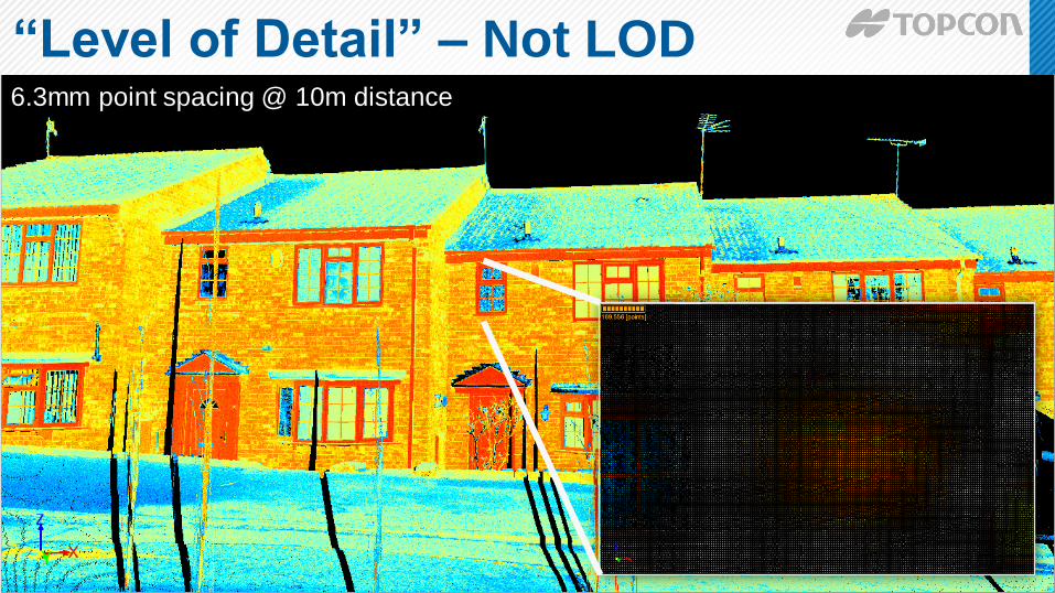
“Level of Detail” – Not LOD 6.3mm point spacing @ 10m distance

“Level of Detail” – Not LOD 3.1mm point spacing @ 10m distance

Registered Point Cloud
Geo-Referenced Point Cloud
3D Wireframe
2D Drawings
3D Surface / Solid Model
Building Information Model
Visualisation
Surveyor
Information
Delivery
Raw Scan Data
Point
Cloud
Options
Vector
Options
Survey Deliverables

RIBA Digital Plan Of Work

How Site Capture Aligns To dPOW
Site Context Required Validation
Operate,
Maintain
+ Update
Site Survey/s Required
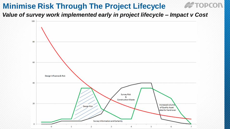
Minimise Risk Through The Project Lifecycle
Value of survey work implemented early in project lifecycle – Impact v Cost

0–Strategic Definition
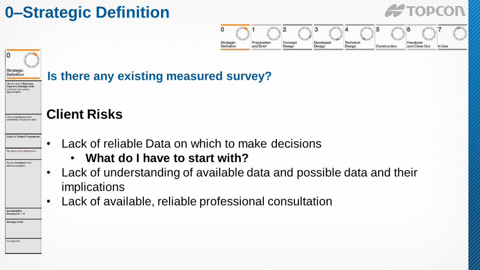
Is there any existing measured survey?
0–Strategic Definition
Client Risks
• Lack of reliable Data on which to make decisions
• What do I have to start with?
• Lack of understanding of available data and possible data and their
implications
• Lack of available, reliable professional consultation

1-Preparation and Brief
Client Risks
• Lack of Survey data
• What is purpose/accuracy/age of the Survey Data
• Different co-ordinate systems
• Misaligned Expectations
• Lack of a Common Technical Language
• Over-surveying or Wrongly identified Data Journey
• Lack of Survey Expertise
Develop project objectives, outcomes, budget, feasibility & brief

PROCESS
TOOLS
WORKFLOW
Mass Data Collection
Software:
Scanmaster
Photography/Mesh/
Pointcloud Point cloud from vehicle mounted mobile laser scan
1-Preparation and Brief

Client Risks • Poor survey specification
• Level of detail
• Accuracy
• Grid
• Lack of survey budget
• Poor design definition
• Lack of or poor Common Data Environment (CDE) & processes
Outline proposals for structural design, building services, project
strategies. Issue final project brief.
2- Concept Design

It’s this easy right?

“Scan 2 BIM”

“Scan 2 BIM”

“Scan 2 BIM”

Client Risks • Failure to verify survey data available
• Resources underused due to waiting for required survey data
• Designers or program delayed due to lack of sufficient survey data
• Survey data delivered but not shared or used to its potential
• Hidden design assumptions in relation to survey data reliability - not
understood or not identified in risk register contingency
Coordinated proposals for structural design, building services,
project strategies, cost information and project strategies
3-Developed Design

Image courtesy of
3-Developed Design

Client Risks • Loss of survey control on site
• Re-surveys = Delays on site, increased cost + risk
• Uncontrolled site changes = Significant lag since last stages of surveys
• Lack of data currency
Prepare Technical Design for architectural, structural and building
services information in accordance with Design Responsibility Matrix
and Project Strategies
4-Technical Design

1. Re-use scan data from previous stages
2. Compare original point clouds to technical design
prior to construction
3. Efficient process, reducing duplication of re-survey
4-Technical Design

Client Risks • Rework causes delays and large additional costs
• Poor survey control
• Offsite manufactured components don’t fit where intended
• Works destruction of survey control
• Coordination of survey activities (e.g. Monitoring v As-built)
• Not recording as-built and planning for hand-back
• Competence of survey resource
• Continued collaboration
Offsite manufacturing and onsite Construction in accordance with
Construction Programme and resolution of Design Queries from site
as they arise.
5-Construction

5-Construction
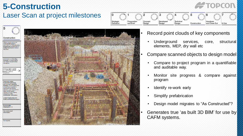
• Record point clouds of key components
• Underground services, core, structural elements, MEP, dry wall etc
• Compare scanned objects to design model
• Compare to project program in a quantifiable and auditable way.
• Monitor site progress & compare against program
• Identify re-work early
• Simplify prefabrication
• Design model migrates to “As Constructed”?
• Generates true ‘as built 3D BIM’ for use by CAFM systems.
5-Construction Laser Scan at project milestones

5-Construction Detect clashes before site work

5-Construction Point clouds in setting out process

5-Construction Setting Out On Site

5-Construction Setting Out On Site
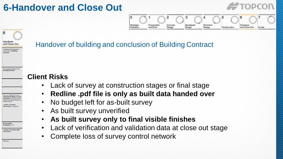
Client Risks
• Lack of survey at construction stages or final stage
• Redline .pdf file is only as built data handed over
• No budget left for as-built survey
• As built survey unverified
• As built survey only to final visible finishes
• Lack of verification and validation data at close out stage
• Complete loss of survey control network
Handover of building and conclusion of Building Contract
6-Handover and Close Out

• Post construction handover drawings and
documents
• Typical Industry current practice
• Set of 2D pdf files derived from design
• Set of Operation & Maintenance manuals
• Measured survey rarely performed
6-Handover and Close Out As Builts – Current Practice

• Generate as built model from multiple stage 5 laser scans
• Hidden objects recorded and validated
• “Whilst built” model compiled in near real time
• The Information of BIM is retained from design/fabrication model
• The FM community rejoice
6-Handover and Close Out As Builts – Future Practice?

Client Risks • No proper as built survey undertaken at end of construction
• Building services (MEP) not verified in as built survey
• Provenance of other peoples data
• Lack of standards, codes & specifications
• RICS client specification is not a standard
• Lack of responsibility for who should update model/CDE when
changes occur
Undertake In Use services in accordance with Schedule of Services
7 - In use

• Minor works and maintenance changes
• Capture every change, or need XX per area to trigger recapture?
• Monitor building performance – combine laser scan with thermal camera
7 - In use

Things to consider if you start
using this data……

Point Cloud Files
Commonly Used
Interoperable File Types
LSPROJ
ZFS
CL3
PTG
PTS PCG
TXT
E57 XYZ
ZFSPROJ
PTX
FLS
ASC
BIN
RDS
CLR
LAS 3DD
RDB
POD
RCS
RCP RXP
RSP
PCD
VTK
PN
SOI

Point Cloud Files
Commonly Used
Interoperable File Types
LSPROJ
ZFS
CL3
PTG
PTS PCG
TXT
E57 XYZ
ZFSPROJ
PTX
FLS
ASC
BIN
RDS
CLR
LAS 3DD
RDB
POD
RCS
RCP RXP
RSP
PCD
VTK
PN
SOI

Data Storage Massive Files ≠ Big data

Thank you.
Questions?