individual property/district maryland historical trust ... · individual property/district maryland...
TRANSCRIPT
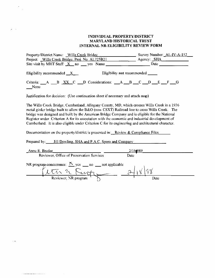
INDIVIDUAL PROPERTY/DISTRICT MARYLAND HISTORICAL TRUST
INTERNAL NR-ELIGIBILITY REVIEW FORM
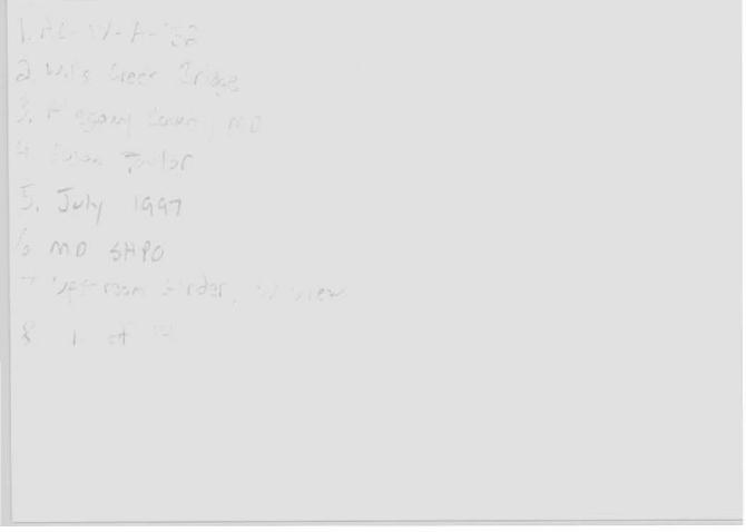
Property/District Name: _W..;...:....:i=ll=s-"C=r=ee=k~B;.c:ri=docg=e _________ Survey Number: AL-IV-A-152 Project: Wills Creek Bridge. Proj. No. AL725B21 Agency: ....;S=HA='------Site visit by MHT Staff: __x_ no _yes Name Date -------
Eligibility recommended X Eligibility not recommended __
Criteria: _A _B XX C _D Considerations: _A _B _C _D _E _F _G _None
Justification for decision: (Use continuation sheet if necessary and attach map)
The Wills Creek Bridge, Cumberland, Allegany County, MD, which crosses Wills Creek is a 1936 metal girder bridge built to allow the B&O (now csxn Railroad line to cross Wills Creek. The bridge was designed and built by the American Bridge Company and is eligible for the National Register under Criterion A for its association with the economic and industrial development of Cumberland. It is also eligible under Criterion C for its engineering and architectural character.
Documentation on the property/district is presented in: Review & Compliance Files
Prepared by:_--'J=il=l-=D'""'o'"""'w~l=in=g.,....~S=HA-==~an=d~P'""".A=-=-. C~. S=--p"-'e=r~o~an=d~C~o=m=-p""-'an==--y _______ _
Anne E. Bruder 21161989 Reviewer, Office of Preservation Services Date
NRprog concurrence: ~ yes _no _not applicable
j_, {/'v'- "'iL ~
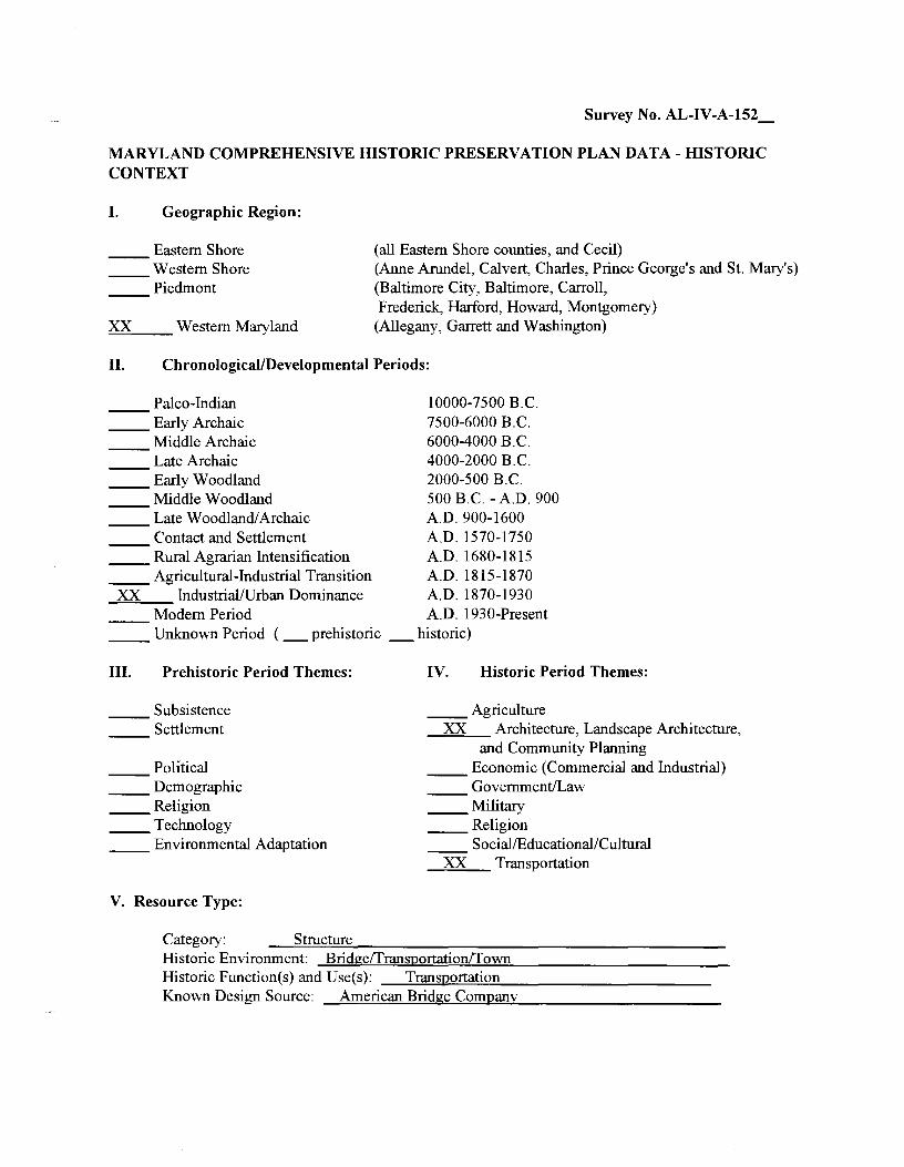
Survey No. AL-IV-A-152_
MARYLAND COMPREHENSIVE HISTORIC PRESERVATION PLAN DATA- HISTORIC CONTEXT
I. Geographic Region:
Eastern Shore Western Shore Piedmont
XX Western Maryland
(all Eastern Shore counties, and Cecil) (Anne Arundel, Calvert, Charles, Prince George's and St. Mary's) (Baltimore City, Baltimore, Carroll, Frederick, Harford, Howard, Montgomery)
(Allegany, Garrett and Washington)
II. Chronological/Developmental Periods:
Paleo-Indian __ Early Archaic
Middle Archaic Late Archaic
__ Early Woodland Middle Woodland Late Woodland/ Archaic Contact and Settlement
__ Rural Agrarian Intensification __ Agricultural-Industrial Transition
XX Industrial/Urban Dominance Modern Period
10000-7500 B.C. 7500-6000 B.C. 6000-4000 B. C. 4000-2000 B.C. 2000-500 B.C. 500 B.C. - A.O. 900 A.O. 900-1600 A.O. 1570-1750 A.O. 1680-1815 A.O. 1815-1870 A.O. 1870-1930 A.O. 1930-Present
__ Unknown Period ( _prehistoric _historic)
III. Prehistoric Period Themes:
Subsistence Settlement
Political __ Demographic __ Religion __ Technology __ Environmental Adaptation
V. Resource Type:
IV. Historic Period Themes:
__ Agriculture XX Architecture, Landscape Architecture,
and Community Planning __ Economic (Commercial and Industrial)
Government/Law __ Military __ Religion
Social/Educational/Cultural XX Transportation
Category: -~S=t=ru=c~tu=r~e'---------------------Historic Environment: Bridge/Transportation/Town Historic Function(s) and Use(s): __ T~r'-"an=sp~o=rta=ti~o""'n'-------------Known Design Source: American Bridge Company
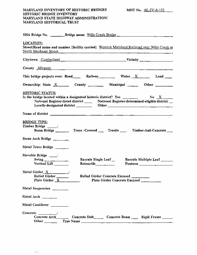
MARYLAND INVENTORY OF HISTORIC BRIDGES HISTORIC BRIDGE INVENTORY MARYLAND STATE HIGHWAY ADMINISTRATION/ MARYLAND HISTORICAL TRUST
SHA Bridge No. ____ Bridge name Wills Creek Bridge
LOCATION:
MHT No. AL-IV-A-152
Street/Road name and number [facility carried] Western Maryland Railroad over Wills Creek at North Mechanic Street
City/town Cumberland Vicinity--------
County ..... AI-=l~e~a=n...,._ _____________________________ _
This bridge projects over: Road__ Railway ___ _ Water ____ x _____ _ Land
Ownership: State ..... X'-=----- County Municipal Other
HISTORIC STATUS: Is the bridge located within a designated historic district? Yes No ---""'X=-----
National Register-listed district __ National Register-determined-eligible district _ Locally-designated district Other ----------------
Name of district
BRIDGE TYPE: Timber Bridge
Beam Bridge __ _ Truss -Covered Trestle Timber-And-Concrete
Stone Arch Bridge
Metal Truss Bridge
Movable Bridge __ :
Swing------ Bascule Single Leaf_ Bascule Multiple Leaf __ _ Vertical Lift ___ _ Retractile ____ _ Pontoon---------
Metal Girder-"-X=------Rolled Girder___ Rolled Girder Concrete Encased ____ _ Plate Girder -=X=------ Plate Girder Concrete Encased ____ _
Metal Suspension
Metal Arch
Metal Cantilever
Concrete Concrete Arch___ Concrete Slab__ Concrete Beam Rigid Frame __ _
Other Type Name-----------------------
AL- \V-A- \Cjr~
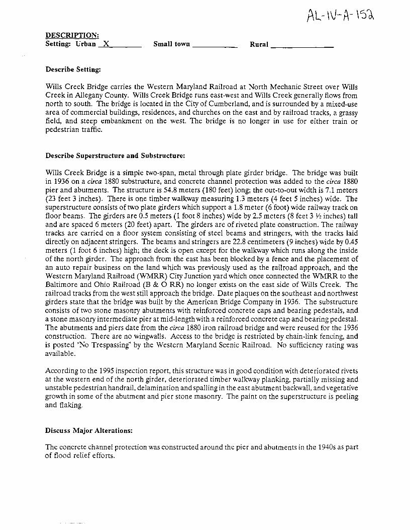
DESCRIPTION: Setting: Urban --=-X=----- Small town ------ Rural~-------
Describe Setting:
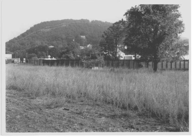
Wills Creek Bridge carries the Western Maryland Railroad at North Mechanic Street over Wills Creek in Allegany County. Wills Creek Bridge runs east-west and Wills Creek generally flows from north to south. The bridge is located in the City of Cumberland, and is surrounded by a mixed-use area of commercial buildings, residences, and churches on the east and by railroad tracks, ci. grassy field, and steep embankment on the west. The bridge is no longer in use for either train or pedestrian traffic.
Describe Superstructure and Substructure:
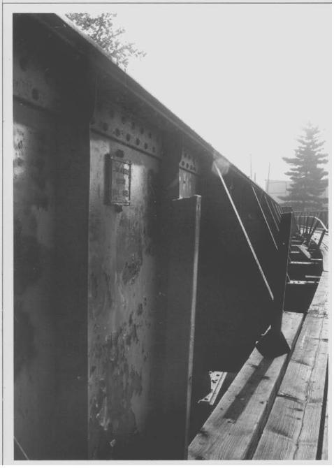
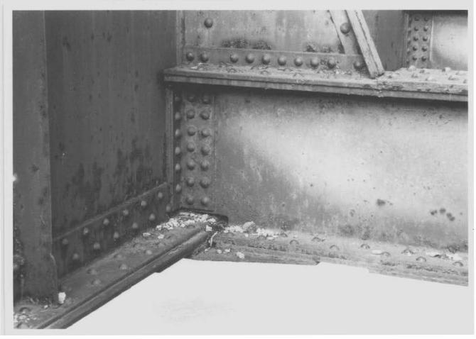
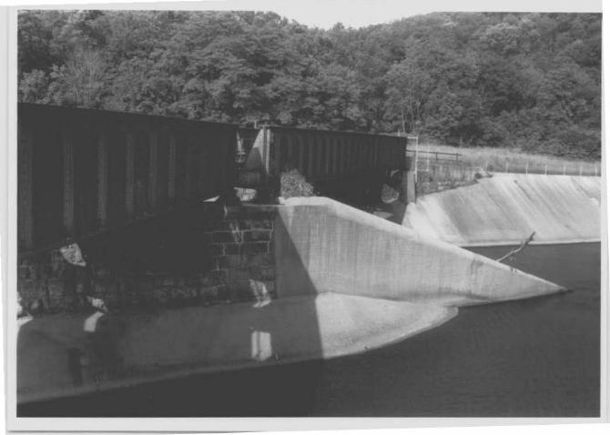
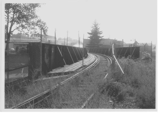
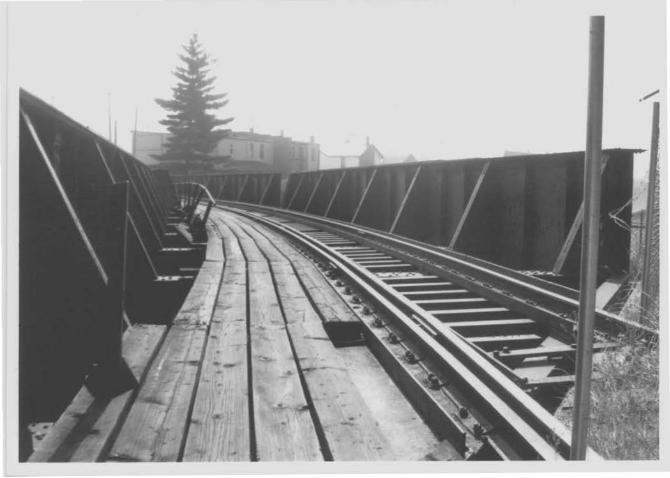
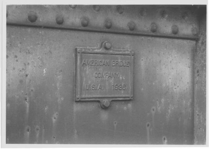
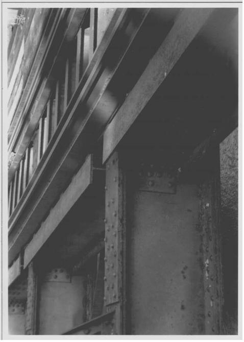
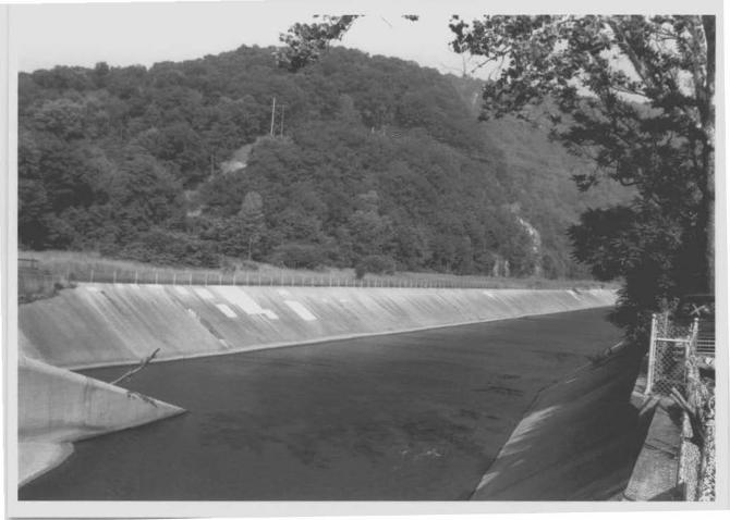
Wills Creek Bridge is a simple two-span, metal through plate girder bridge. The bridge was built in 1936 on a circa 1880 substructure, and concrete channel protection was added to the circa 1880 pier and abutments. The structure is 54.8 meters (180 feet) long; the out-to-out width is 7.1 meters (23 feet 3 inches). There is one timber walkway measuring 1.3 meters (4 feet 5 inches) wide. The superstructure consists of two plate girders which support a 1.8 meter (6 foot) wide railway track on floor beams. The girders are 0.5 meters (1 foot 8 inches) wide by 2.5 meters (8 feet 3 1/2 inches) tall and are spaced 6 meters (20 feet) apart. The girders are of riveted plate construction. The railway tracks are carried on a floor system consisting of steel beams and stringers, with the tracks laid directly on adjacent stringers. The beams and stringers are 22.8 centimeters (9 inches) wide by 0..45 meters (1 foot 6 inches) high; the deck is open except for the walkway which runs along the inside of the north girder. The approach from the east has been blocked by a fence and the placement of an auto repair business on the land which was previously used as the railroad approach, and the Western Maryland Railroad (WMRR) City Junction yard which once connected the WMRR to the Baltimore and Ohio Railroad (B & 0 RR) no longer exists on the east side of Wills Creek. The railroad tracks from the west still approach the bridge. Date plaques on the southeast and northwest girders state that the bridge was built by the American Bridge Company in 1936. The substructure consists of two stone masonry abutments with reinforced concrete caps and bearing pedestals, and a stone masonry intermediate pier at mid-length with a reinforced concrete cap and bearing pedestal. The abutments and piers date from the circa 1880 iron railroad bridge and were reused for the 1936 construction. There are no wingwalls. Access to the bridge is restricted by chain-link fencing, and is posted "No Trespassing" by the Western Maryland Scenic Railroad. No sufficiency rating was available.
According to the 1995 inspection report, this structure was in good condition with deteriorated rivets at the western end of the north girder, deteriorated timber walkway planking, partially missing and unstable pedestrian handrail, delamination and spalling in the east abutment backwall, and vegetative growth in some of the abutment and pier stone masonry. The paint on the superstructure is peeling and flaking.
Discuss Major Alterations:
The concrete channel protection was constructed around the pier and abutments in the 1940s as part of flood relief efforts.
AL-1v-·A.-i5~ HISTORY:
WHEN was the bridge built: =19;..::3:..::6'--------This date is: Actual X Estimated -------Source of date: Plaque _x_ Design plans _x_ County bridge files/inspection form: __ Other (specify) :
WHY was the bridge built?
The bridge was constructed to connect the Western Maryland Railroad (WMRR) with the B & 0 Railroad system at the WMRR City Junction Yard, after the previous bridge superstructure was destroyed in a flood during March of 1936. The earlier bridge was constructed circa 1880, and was built to join the Georges Creek and Cumberland Railroad (GC & C RR) with the Roundtop, Huntington, and Pennsylvania Railroad (RTH & P RR) at the GC & C RR roundhouse, later the WMRR roundhouse, which once existed on the east side of the North Centre Street and North Mechanic Street intersection.
WHO was the designer?
American Bridge Company
WHO was the builder?
American Bridge Company
WHY was the bridge altered?
The bridge was altered as flood control measures were established in the 1940s.
Was this bridge built as part of an organized bridge-building campaign?
The bridge was built to replace the circa 1880 iron railroad bridge which was destroyed in the flood of March 1936. Though other railroad and highway bridges were destroyed during the same flood, there is no evidence that the Western Maryland Railroad was responsible for re-building other bridges.
SURVEYOR/HISTORIAN ANALYSIS:
This bridge may have National Register significance for its association with: A • Events X B· Person _____ _ C- Engineering/architectural character _X ___ _
The bridge is eligible for the National Register of Historic Places under Criterion A, for its association with the economic and industrial development of the City of Cumberland. The Wills Creek Bridge served as an important connection between two main rail lines, the Baltimore and Ohio and the Western Maryland, in a city where the railroads got their early industrial start. The bridge connected the two lines at the Western Maryland Railroad City Junction yard on the east side of Wills Creek. As a coal town, the city of Cumberland depended on the railroads to make their product accessible. The railroad was important to the development of the town not only in its own right as an industry and transportation route, but also for its part in enticing and retaining other
1~ L-· \ \J -A- l 51 industries to the area. The early- to mid-twentieth century development of tire manufacturing and chemical manufacturing was encouraged by the easy and efficient access to main transportation routes. Though a replacement of an earlier bridge, the Wills Creek Bridge was built when the railroads remained one of the driving forces in Cumberland life, and emphasized the connection between the B & 0 and WMRR into the second quarter of the twentieth century. The bridge also meets Criterion C, as a significant representative example of metal girder construction. The structure has a high degree of integrity and retains such character-defining elements of the type as riveted metal plate girders, floor beams, and circa 1880 stone masonry abutments and pier, though the substructure is visually obscured by concrete. As one of the last surviving pieces of the elaborate railroad network that operated in the Cumberland region in the early- to mid-twentieth cent11ry, the Wills Creek Bridge retains not only historic significance, but also design significance as an excellent example of a once common type of railroad bridge.
Research indicates that the bridge has no association with persons who have made specific contributions to history, and therefore, it does not meet Criterion B. In addition, the structure has no known potential to yield important information, and therefore, is not eligible under Criterion D.
Was the bridge constructed in response to significant events in Maryland or local history?
Metal girder bridges were most likely introduced and first popularized in Maryland by the state's major railroads of the nineteenth century including the Baltimore and Susquehanna, its successor the Northern Central, and the Baltimore and Ohio Railroad. Bridge engineering historians have documented the fact that James Milholland (or Mulholland) erected the earliest plate girder span in the United States on the Baltimore and Susquehanna Railroad in 1846 at Bolton Station, near present-day Mount Royal Station. The sides (web) and bottom flange of Milholland's 54-foot-long span were wholly of wrought iron and included a top flange reinforced with a 12x12-inch timber. Plates employed in the bridge were 6 feet deep and 38 inches wide, giving the entire bridge a total weight of some 14 tons. Milholland's pioneering plate girder cost $2,200 (Tyrrell 1911:195). By December 31, 1861, the Northern Central Railroad, which succeeded the Baltimore and Susquehanna, maintained an operating inventory in Maryland of 50 or more bridges described simply as "girder" spans, in addition to a number of Howe trusses. Most of these were probably iron girder bridges; the longest were the 117-foot double-span bridge over Jones Falls and the 106-foot doublespan girder bridge at Pierce's Mill (Gunnarson 1990:179-180).
Under the impetus of the railroads, metal girder bridge design and construction reached full development during the last quarter of the nineteenth century. Prominent bridge engineer Theodore Cooper, a key proponent of empirical bridge design and standardization, observed in 1889 that plate girders were "generally used for spans up to 65 feet and give excellent satisfaction" when riveted at the bridge fabrication shop (P.A.C. Spero & Company 1991:147-148). Crediting the "great advance in the science of detailing and proportioning" for the increasingly scientific approach to design of rolled I-beam spans and plate girders, Waddell dated popular recognition of the "great value of plate-girders for short spans" to the 1880s. By 1905, standard design plans and specifications for all types of girder bridges were available through such organizations as the American Railway Engineering Association and the American Society of Civil Engineers, and such prominent private bridge building firms as the American Bridge Company.
Plate girder bridges were typically riveted in the shop and shipped by rail to the intended sites. As in the case of metal trusses, the introduction of the portable pneumatic riveter allowed some early twentieth century plate girders to be riveted in the field, but as Waddell observed in 1916, there were many important shipment and construction considerations:
Usually it is the difficulty of shipping very long plate-girders from bridge shop to site that determines the superior limit of such spans. The loading of long girders on cars for shipment is quite an art, and it should be entrusted only to men experienced in such loadings; for, otherwise, the metal is liable to be injured in transit or the cars break down .... About as long a plate-girder as has ever been shipped in one piece was one of one hundred and thirty-two (132) feet. It required four flat cars to transport it. Longer plate-girder spans than this have been built, notably tubular bridges and sv.ing spans, but they were shipped in parts and assembled at site. This expedient for simple spans is really permissible only in case of bridges to be sent to foreign countries, and it is to be avoided if possible even then, because it is sometimes difficult to obtain a satisfactory job of field-riveting when making the splices, although the use of pneumatic riveters tends to reduce materially the force of this objection (Waddell 1916:409).
Girder bridge construction on the Baltimore and Ohio Railroad (B & 0 RR) received a boost between 1901 and 1908, when former Pennsylvania Railroad Chief Engineer Leonor Loree took charge of a major rebuilding of the B & 0 main and branch lines. Aiming to refit the railroad so that it could safely run 2,500-ton coal trains behind heavy locomotives, Loree ordered construction of a combination deck girder and through truss bridge at the Ilchester tunnel, a seven-span deck plate girder bridge over the Monocacy River, a girder replacement for the old Bollman truss over Tuscarora Creek, and steel plate girder center spans for several trestles along the B & O's Georgetown Branch in Montgomery County (Harwood 1979:passim). Loree and his immediate predecessors also constructed many girder spans during the rebuilding of the Washington County Branch leading to Hagerstown between 1890 and 1908 (Harwood 1979:375).
The Wills Creek Bridge remains a significant reminder of early to mid twentieth century history of the Western Maryland and Baltimore and Ohio railroads, and of the economic and transportation history of the Cumberland, Maryland region. The bridge was built in 1936 as a replacement for a circa 1880 iron railroad bridge, and connected the Western Maryland Railroad (WMRR) which ran along the south and west sides of Wills Creek to the B & 0 RR which ran along the north and east sides of the creek at the WMRR City Junction Yard. The B & 0, like the National Road before it, gave Cumberland its character as a cross-roads and transportation center and made it an important stopping point (Brugger 1988:335). Cumberland was the first major western city to be reached by the B & 0 (Vance 1995:40). With its extension into Cumberland, the B & 0 gained access to the bituminous coal fields of the Appalachian Plateau which would eventually make it a rich company, setting the stage for other lines to follow in the business of coal production and shipping. These coal roads saved the B & 0 and its later subsidiaries from extinction after competition from trucking, buses, and airlines grew after World War II (Vance 1995:121). During the years in which the B & 0 owned controlling interest in the Western Maryland Railroad but was unable to exercise it due to a ruling by the Interstate Commerce Commission, the Wills Creek Bridge emphasized the need to connect the two railways while maintaining separate identities. The bridge served as part of the rail line which connected Cumberland and Frostburg to the western coal producing areas. The current Wills Creek Bridge was built to replace a circa 1880 iron railroad bridge which was destroyed in the flood of 1936. On March 17, 1936 heavy rains and melting snow caused flood waters to inundate the City of Cumberland, covering the streets, flooding all the bridges which crossed Wills Creek except the railroad viaduct, and stopping all Western Maryland Railroad service and destroying the older bridge which connected the B & 0 and WMRR. (Stegmaier et al 1976:363-367).
Cumberland was the main shipping point for the vast amounts of coal which were being mined from areas to the west. The original circa 1880 bridge was constructed to connect the Georges Creek and Cumberland Railroad with the Roundtop, Huntington, and Pennsylvania Railroad (Sanborn 1887).
Both were short lines of the Pennsylvania Railroad, built to circumvent the Cumberland and Pennsylvania (C & P) Railroad which had previously held a monopoly on rail lines to the major coal producing areas of Maryland (Mellander 1981: 7-9). When the Western Maryland Railroad took control of the GC & C RR lines in 1907, they gained access to the coal fields. Connecting Cumberland to the east coast, the Western Maryland Railroad supplied coal to cities and many major metropolitan power plants on the east coast. The early-twentieth century was the heyday of coal shipment for the Western Maryland. The company was quickly adding lines into coal fields and out to consumers. In 1913 the Western Maryland began operation of the line to the George's Creek coal territory close to Lonaconing, Maryland, west of Cumberland. In 1916, it took over operation of two small coal branches close to Fairmont, West Virginia. Though the two lines were isolated from the main WMRR track, they were reached over lines owned by the B & 0. The WMRR moved metallurgical coal from Bethlehem Steel Company's mine in the region over one of these lines. In the late 1920s the WMRR took over control of a line running from southwest of Elkins, West Virginia to the WMRR branch at Durbin, Maryland. Another line extended service down the Elk River to Webster Springs, West Virginia. A final acquisition came with the control of the C & P RR during World War II. The C & P had developed from industrial lines established in the mid-nineteenth century, linking an iron-rolling mill to coal mines, and the mines to the Chesapeake & Ohio Canal (C & 0) (Leilich 1986:78-80).
Throughout Cumberland's history, transportation was a major incentive for the development of the city. Located at the confluence of Wills Creek and the Potomac River, the city took advantage of its location at the gap of the Appalachian mountains to become the center of a transportation network. Cumberland served not only as the eastern terminus of the National Road, but also as the western end of the C & 0 Canal. The railroad took advantage of these pre-existing routes, encouraging even greater economic development. At the turn of the twentieth century, the railroad industry employed over 2,000 people in Cumberland, and brought raw materials to and shipped products from the twenty-nine mills, factories, and foundries which operated in the city. Local citizens worked on road crews, locomotive facilities, repairs shops, and yards of the various railroads. The twentieth century was a boom time for the City of Cumberland (Stegmaier et al 1976:221-232).
The 1920s brought tremendous growth to the area. Though the coal industry was slowly declining, due in part to over-production following the opening of new mines to meet the demands of World War I, Cumberland had a strong, mixed economy. Encouraged by the efforts of the Chamber of Commerce, the Kelly-Springfield Tire Plant opened in Cumberland in 1920. The 1924 opening of Cellulose and Chemical (Celanese) Manufacturing encouraged even greater diversity (Leilich 1986:325-326). During this decade Cumberland supported the N & G Taylor Company, a terneplate roofing and tinplate manufacturer, the Klots Company, a silk throwing mill, Footer's Dye Works Plant, the Union Tanning Company, Paragon Motor Company, and several glassmaking, brewing, and timber/paper companies. The availability of a good transportation network provided by the railroads was a major factor in attracting businesses to the area (Leilich 1986:314-316). The Depression and prohibition had a negative impact on many of these businesses, but the KellySpringfield Tire Company, the Westvaco Company (a paper mill), Celanese Fibers Corporation, and the Chessie System Railroad, which resulted from the merger of several railroads, including the B & 0 and WMRR, remain major industries today (Hattery 1980:36).
The railroads not only expanded employment and business opportunities in the area, but also provided most of the travel and transportation needs for local residents during the early to midtwentieth century. Some of the passenger trains which served Allegany County included the New York-Cincinnati-St. Louis Limited, The New York-Chicago Limited, and the New York-Chicago Special. Local travel also originated in Cumberland, departing from either the B & O's Queen City Station or from the Western Maryland Railroad Station. A through train from Baltimore and Hagerstown to Elkins, West Virginia stopped at the WMRR station in Cumberland. Serving the
t~L- IV-A-16~ eastern Allegany County towns of Spring Gap, Oldtown, Town Creek, Kiefer, Green Ridge, and Little Orleans, this train provided the only public transportation to these towns. Trains also went westward from the WMRR station, providing small Maryland towns west of Cumberland such as Rawlings, Dawson, McCoole, Westernport, and Luke with twice-daily service. The Pennsylvania Railroad serving the Bedford County, Pennsylvania area also used the Western Maryland Depot. Some Western Maryland tracks were also used by the trolley route which served Cumberland's west side (Stegmaier et al 1976:331-335).
The 1936 construction of the Wills Creek Bridge occurred at a significant time in the development and expansion of the Western Maryland Railroad. The WMRR first entered the City of Cumberland in 1906. In 1907 they bought control of the Georges Creek and Cumberland line to the western coal fields. The Western Maryland opened its new passenger terminal on Baltimore and Canal Streets in 1913. In 1927, the B & 0 Railroad bought 43 percent of Western Maryland's stock. During this time period, the federal government was encouraging a plan that would consolidate many of the smaller rail lines into four large systems covering the eastern territory. The exceptional location of the WMRR between the east coast and major coal producing areas in western Maryland, western Pennsylvania, and West Virginia made it a direct challenge to B & O's eastern territory. Though the B & 0 bought controlling interest in the WMRR to protect itself, the company was unable to exercise direct control of the company due to Interstate Commerce Commission regulations. The Western Maryland Railroad was able to remain independent and competitive with the B & 0 due to the placement of B & O's WMRR stock in a voting stock (Leilich 1986:80).
During the 1960s, railroads were merging into increasingly larger conglomerates. The B & 0 merged with the Chesapeake and Ohio Railroad (which operated from Virginia to the Ohio River), becoming known as the Chessie System, which later subsumed the Western Maryland Railroad. As the 1960s and 1970s progressed competition among railroad systems became increasingly fierce. Citing the changing competitive nature of the business, the B & 0 began to petition for the right to exercise its control of the Western Maryland Railroad directly. The B & 0 (Chessie) took control of the WMRR in 1968, though the WMRR continued to act as a separate corporate entity into the mid-1970s. Conrail competed directly with Chessie, and closed many of the interline routes once used by the WMRR. No longer able to stand on its own, the WMRR found itself in a position where it largely duplicated the lines of its owner, and the WMRR lines were abandoned throughout the 1970s and 1980s (Leilich 1986:80-84).
When the bridge was built and/or given a major alteration, did it have a significant impact on the growth and development of the area?
The bridge provided an important and necessary link between the B & 0 Railroad and the Western Maryland Railroad at the WMRR City Junction Yard, encouraging many industries to locate in Cumberland to take advantage of the transportation system. The industries, in turn, promoted much of the residential and commercial growth of Cumberland in the early- to mid-twentieth century.
Is the bridge located in an area which may be eligible for historic designation and would the bridge add to or detract from the historic/visual character of the potential district?
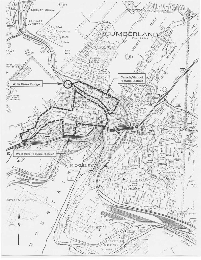
The bridge is located in an area which does not appear to be eligible for historic designation. Though close to both the West Side Historic District and the CanadaNiaduct Historic District, the bridge is located outside the boundaries of both, and is separated by modern development which would preclude the expansion of these district boundaries to include the Wills Creek Bridge. The Wills Creek Bridge is located to the northwest of the boundaries of the West Side Historic District. While the northern edge of the West Side Historic District runs along the top of a hill, the Wills Creek Bridge crosses Wills Creek in the valley below the hill. Surrounded by deserted railroad
AL--\\J-A-l5d, tracks, a meadow, and the side of the hill, the Wills Creek Bridge is completely separated from the West Side Historic District. The bridge is located south of the southern boundary of the CanadaNiaduct Historic District. The northern boundary line once followed the curve of the railroad tracks which have subsequently been removed. The boundaries from 1976 extend to the northern bank of Wills Creek but do not include the bridge. The bridge is separated from the CanadaNiaduct district by an area of modern development, including several commercial establishments, which stand in the area once occupied by the Western Maryland Roundhouse and railroad yards.
Is the bridge a significant example of its type?
The bridge is a potentially significant example of a metal girder bridge, possessing a high degree of integrity.
Does the bridge retain integrity of important elements described in Context Addendum?
Metal girder bridges are structures in which a floor system and roadway are supported by parallel metal beams or girders, which are carried by concrete, masonry, or metal supports (abutments or piers). Plate girders are characterized as girders built-up of riveted sections, rather than a single rolled section. Components of the girder are the flanges (horizontal portion) and the webs (vertical portions).
The bridge retains the character-defining elements of its type, as defined by the Statewide Historic Bridge Context, including riveted metal girders, floor beams, stone masonry pier and abutments. The stone masonry pier and abutments still exist, but are visually obscured by concrete.
Is the bridge a significant example of the work of a manufacturer, designer, and/or engineer?
This bridge is a significant example of the work of the American Bridge Company. Designed in 1936, the bridge is representative of the simple through plate girder plans which were developed under the impetus of the railroads and standardized in the early-twentieth century by such companies as the American Bridge Company.
Should the bridge be given further study before an evaluation of its significance is made?
No further study of this bridge is required to evaluate its significance.
BIBLIOGRAPHY:
Brugger, Robert A. 1988 Maryland, A Middle Temperament 1634-1980. Johns Hopkins University Press, Baltimore and
London.
Feldstein, Albert L., ed. 1986 Feldstein's 50th Anniversary Commemorative Edition of the Saint Patrick's Day Flood,
Cumberland, Maryland--March 17, 1936. Commercial Press Printing Co., Cumberland, Maryland.
Gunnarson, Robert 1990 The Story of the Northern Central Railway, From Baltimore to Lake Ontario. Greenberg
Publishing Co., Sykesville, Maryland.
AL- IV-A.-1S~ Harwood, Herbert H., Jr. 1979 Impossible Challenge: The Baltimore and Ohio Railroad in Maryland. Barnard, Roberts and
Company, Baltimore.
Hattery, Thomas H., ed. 1980 Western Maryland: A Profile. Lomond Books, Mt. Airy, Maryland.
Jacobs, Timothy, ed. 1989 The History of the Baltimore and Ohio: America's First Railroad. Crescent Books,
New York.
Johnson, Arthur Newhall 1899 The Present Condition of Maryland Highways. In Report on the Highways of Maryland.
Maryland Geological Survey, The Johns Hopkins University Press, Baltimore.
Keller, Genevieve 1976 AL-IV-A-142 CanadaNiaduct Historic District Inventory Form. Maryland Historical
Trust, Annapolis. ·
Keller, Genevieve 1976 AL-IV-A-145 West Side Historic District Inventory Form. Maryland Historical
Trust, Annapolis.
Leilich, George M. 1986 "The Western Maryland: A Corporate History." In Railroad History. Bulletin 155.
The Railway and Locomotive Historical Society, Inc.
· Mellander, Deane E. 1981 Rails to the Big Vein: The Short Lines of Allegany County. Potomac Chapter, National
Railway Historical Society, Maryland.
P.A.C. Spero & Company 1991 Delaware Historic Bridges Survey and Evaluation. Report for Delaware Department of
Transportation, Wilmington, Delaware.
Sanborn Map Company 1887 Sanborn Fire Insurance Maps for Cumberland, Maryland. Sanborn Map Company, New
York.
Stegmaier, Harry, Jr. et al. 1976 Allegany County--A History. McClain Printing Company. Parsons, West Virginia.
Tyrrell, Henry G. 1911 History of Bridge Engineering. Published by author, Chicago.
Vance, James E., Jr. 1995 The North American Railroad: Its Origin, Evolution, and Geography. Johns Hopkins
University Press, Baltimore and London.
Waddell, J.A.L. 1916 Bridge Engineering. John Wiley and Sons, Inc., New York.
AL-\V-A-15~ SURVEYOR:
Date bridge recorded _____ 7""'3""'9;...:.7 __________________ _
Nameofsurveyor _____ Su~s~a_n_T_a_y~lo~r---------------------~ Organization/Address P.A.C. Spero & Co., 40 W. Chesapeake Avenue, Suite 412, Baltimore. MD 21204 Phone number(410) 296-1635 FAX number (410) 296-1670
AL-IV--A- l51
Boundaries for the West Side Historic District, CanadaNiaduct Historic District, and Location of the Wills Creek Bridge
According to the Maryland Historical Trust Sites Inventory Form written in 1976, the West Side Historic District sits on top of a hill above Wills Creek and is bounded on the north by a line from 'Wills Creek along the western edge of Tilghman Street to the northern edge of Fayette Street and then west to Karns Avenue. On the west, the district runs south along the rear property lines on the west side of Fayette Street from Karns Avenue to the rear property lines on the west side of Braddock Road to the alley known as Sandringham Circus. The south boundary runs east from Sandringham Circus along the northern edge of U.S. Route 48, to the rear property lines on the south side of Gephart Drive which becomes Lowndes Terrace to the intersection with McKinley Avenue and southward along the eastern edge of Locust Street to the northern edge of U.S. Route 48. From this point the boundary line extends north along the rear property lines on the east side of Allegany Street to the rear lines on the south side of Green Street east to Wills Creek. The eastern boundary is defined as Wills Creek.
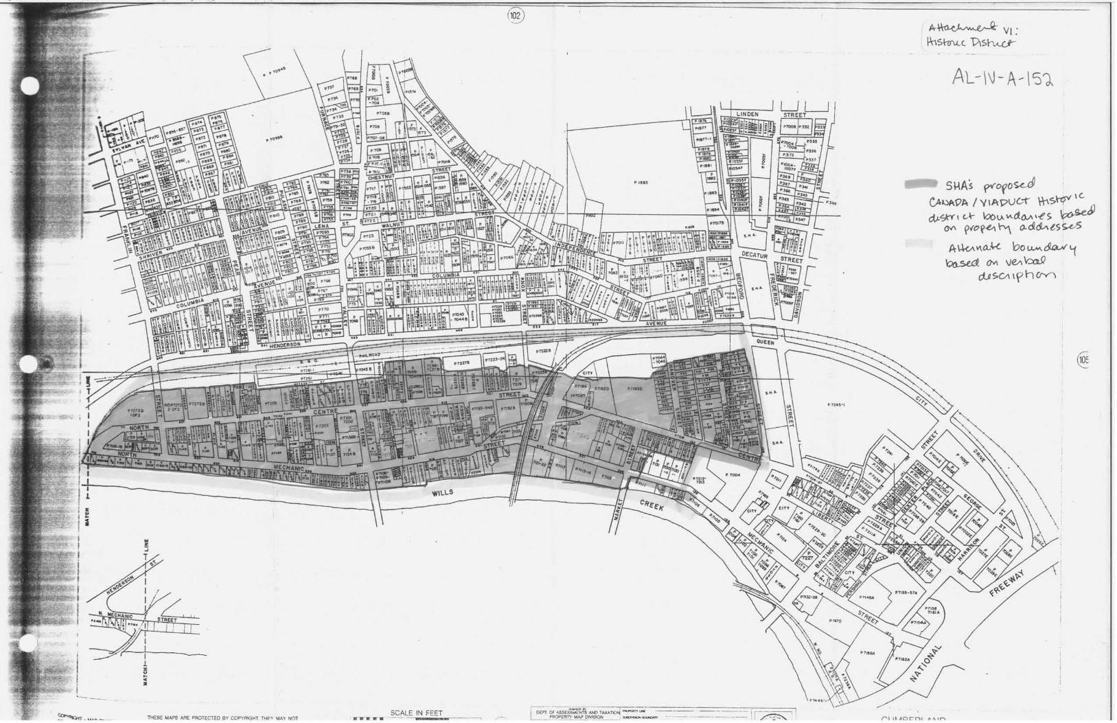
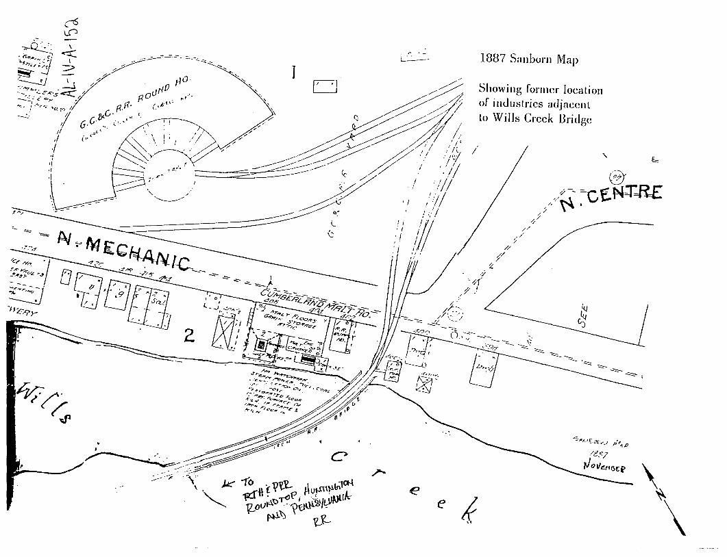
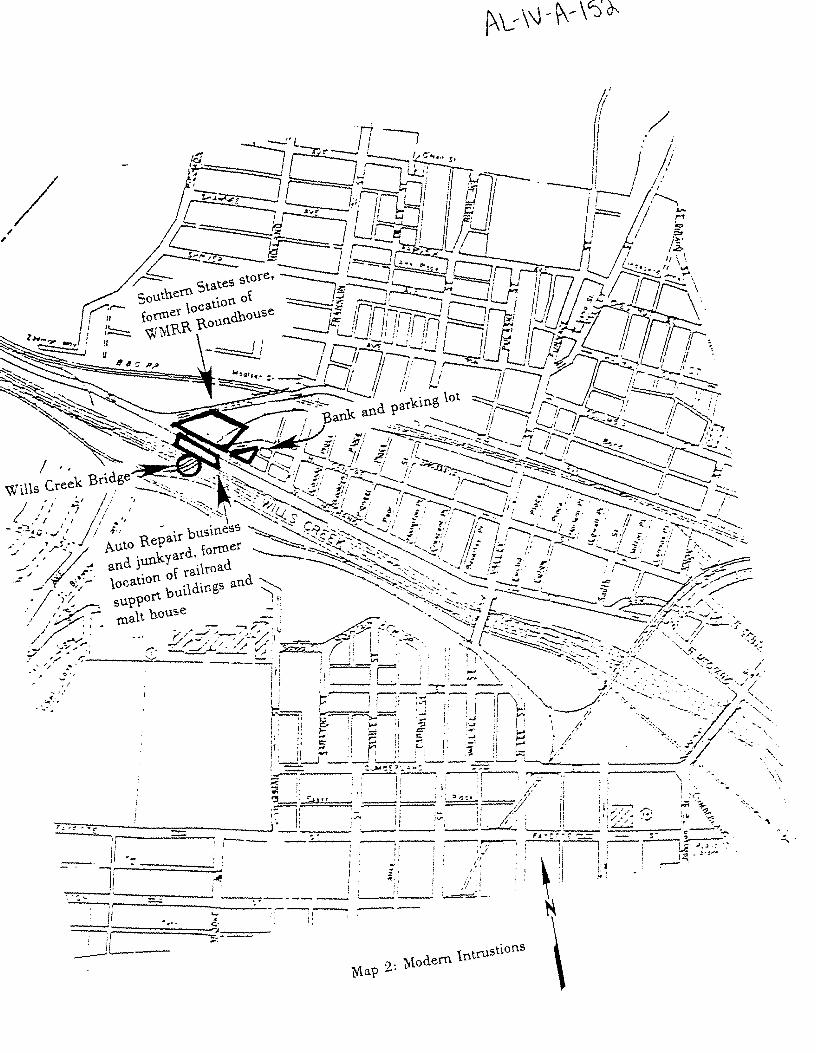
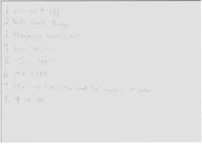
The verbal boundary description written in the 1976 Maryland Historical Trust Sites Inventory Form describes the CanadaNiaduct Historic District boundaries as follows: the district is bounded on the north by the B & 0 Railroad tracks and on the south by Wills Creek. The western boundary is the intersection of North Centre and North Mechanic Streets. The eastern boundary runs from the northern property line of the John F. Kennedy high-rise apartment building between North Mechanic and North Centre streets to the northern side of North Centre Street and the southern edge of Bedford Street from North Centre Street to the B & 0 Railroad. The verbal description of the district boundaries included the follo\\ing streets with inclusive street numbers: 101 to the Wills Creek Bridge on North Centre Street, 105-147 Hanover Street, 307 to the Wills Creek Bridge on North Mechanic Street, 107-150 Polk Street, and 110-160 Bedford Street (even numbers only). The Wills Creek Bridge was not included within the boundaries, though it is immediately adjacent to the boundaries. At the time the survey was completed, the potential contribution of the bridge to the district was not taken into consideration. The extension of the boundaries to include the Wills Creek Bridge is not recommended, as the intrusion of latetwentieth century commercial development has replaced the historic industrial buildings, railroad buildings and approaches which once surrounded the bridge. The railroad tracks approaching the bridge have been removed (photo 1), an auto repair shop with a junkyard lies directly in front of the approach (photo 2), a Southern States building lies in the area where the Western Maryland Railroad Roundhouse once stood (photo 3), and many of the industrial buildings which once surrounded the area, including several railroad support buildings, and the Cumberland Malt house, no longer exist (see included Sanborn Map). Though the bridge is an important element in the industrial history of Cumberland, many of the buildings which once linked the 'Wills Creek Bridge with the Canada/Viaduct district are missing or lie at the opposite end of the district and are no longer connected by rail. The northern boundary line of the district followed the curve of the railroad tracks down to the 'Wills Creek Bridge; the tracks have subsequently been removed and no longer serve as an effective boundary demarcation.
The Wills Creek Bridge is located to the northwest of the boundaries surrounding the West Side Historic District. While the northern edge of the West Side Historic District runs along the top of a hill, the Wills Creek Bridge crosses Wills Creek in the valley below the hill. Surrounded by deserted railroad tracks, a field, and the side of the hill, the Wills Creek Bridge is completely cut-off from the West Side Historic District. The bridge is located south of the southern boundary for the CanadaNiaduct Historic District. The boundaries from 1976 extend to the northern bank of Wills Creek, but do not include the bridge. The northern boundary line once followed the curve of the missing railroad tracks. An area of modern development lies between the bridge and the historic district, comprised of a Southern States store building at the former location of the Roundhouse (Sanborn Map), an auto repair shop with a junk yard directly in front of the bridge, and a bank and parking lot on the point of land af the intersection of North Centre and North Market Streets (see map 2). This modern commercial development replaces the historic malt house, railroad support buildings, roundhouse, and railroad tracks which once contributed to the nature of the area, and the new development separates the bridge from the historic area.
~ ........ __ _ .-. • .-w SCALE IN FEET r 1 i
/~ f'I l ~ AOC"D I ..,
AL-\\J -A-\51
SHAs f>v'Ofo~ CA~9A I Y\A)?UG--t' \hS~ 1G
c:t,L'SkY° I cA- \Qo lA \A. d()..11 \-t' S ~ &A ~'0~~"""" o.&~ess.vs
boU-M.~~ VeA~
dJ SCI\ \ f h CrYl
e
1887 Sanborn Map
Showing former localion of in<lusLries a<ljacenL Lo Wills Creek llridgc
~ .')
// /./ /'
. -0''
/ f' -'
\ \
'lOWS ·RK
0
.- :~ ,., ., .. . .,.,, ..
. .
f,~~?o •r:•'
"" ,. . ' ' " '
·""-'" :; I ISd\l . ··.
/
/
/ /
/
/
·t"' ~ ;~·oo ............ .,.
CanadaNladuct Historic District
."' \
• •CU
.. ~,
~ ': ( ~
r-r.::. - -,_ .

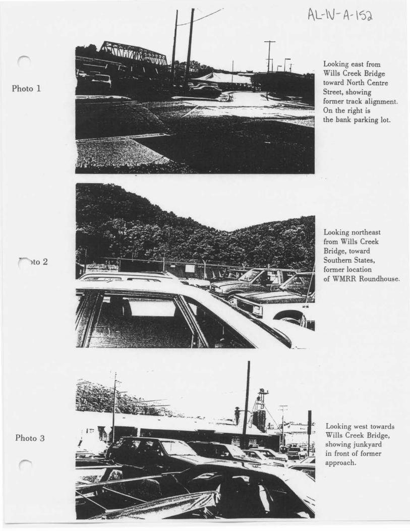
Photo 1
Ho 2
Photo 3
f\L-\\J - A-- \'))
Looking east from Wills Creek Bridge toward North Cent.re Street, showing former track alignment. On the right is the bank parking lot.
Looking northeast from Wills Creek Bridge, toward Southern States, former location of WMRR Roundhouse.
Looking west towards Wills Creek Bridge, showing junkyard in front of former approach.
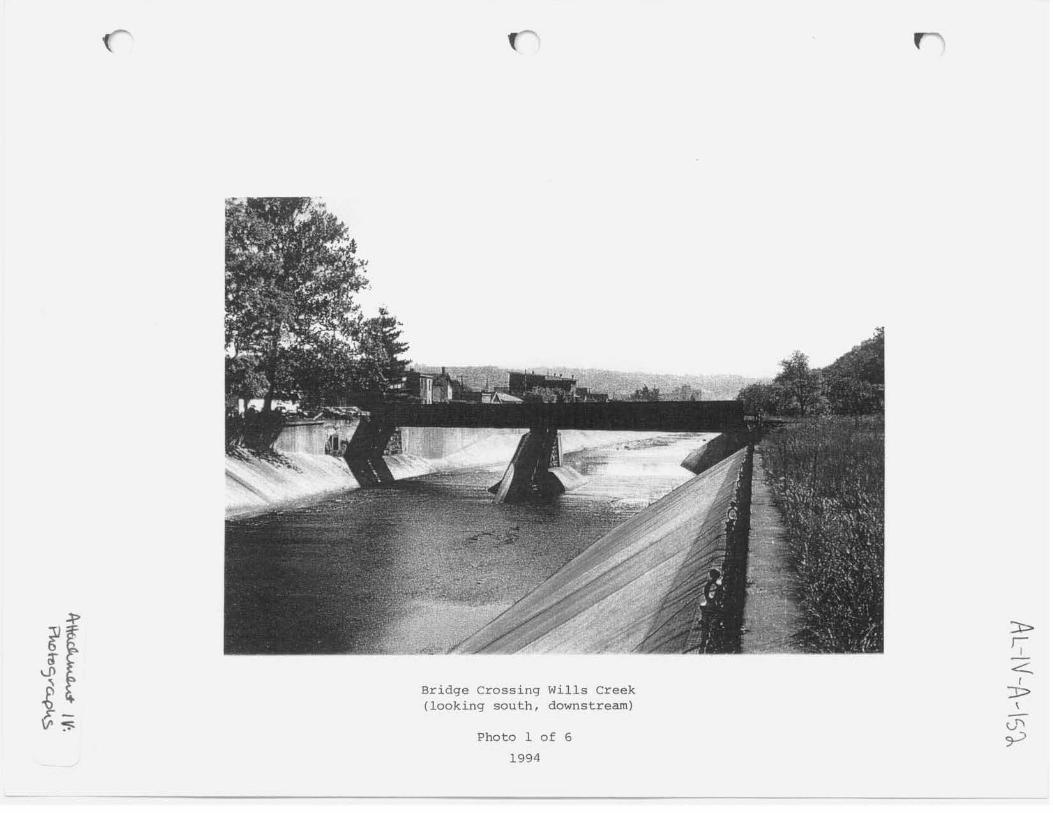
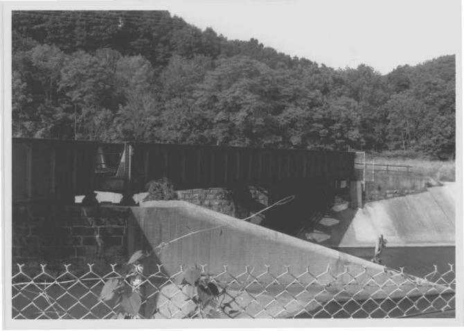
Bridge Crossing Wills Creek (looking south, downstream)
Photo l of 6
1994
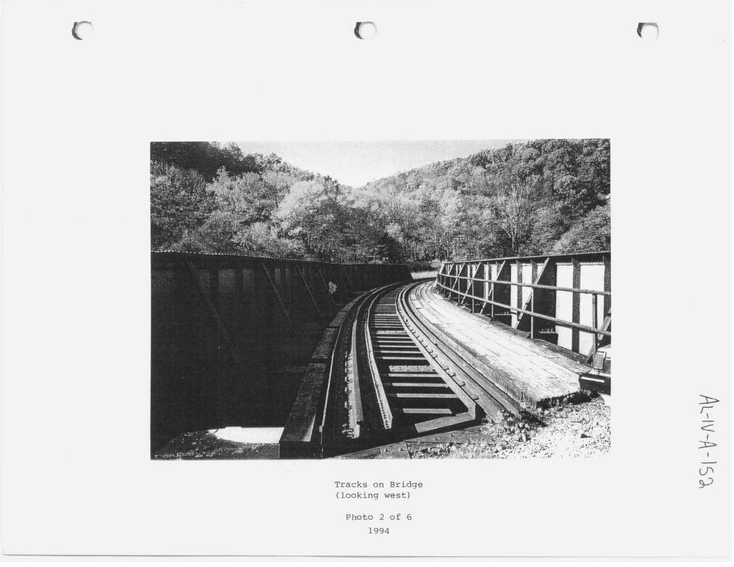
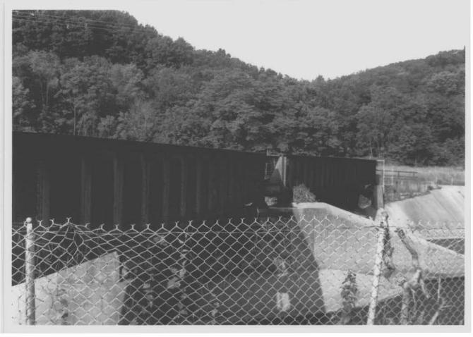
Tracks on Bridge (looking west)
Photo 2 of 6
1994
Former Mechanic Street Grade Crossing (looking west)
Photo 3 of 6 1994
Parmer- Track Roadbed/Alignment @ Southern States (looking west)
Photo 4 of 6
1994 tJ\ ~')
Former Trnck Roadbed 1\liqnment ra Franklin Street Crossinq < lookinq north)
Photo S of r;
1994
-
-'"' v
/",

f4: r
~ I 0 r . l
,- ~ """~' 1,,(1\,/AJ ~. A' t)
J ~v .. r
1 ... ~ "'., ,.,, Ir r.) - ' 'rd tr '.1 .., -J. ') . -f I -

I r ~ I - r , ) - C'
I ,r }.} /(? t" , (
f vi ~ :,, /
:, j.
f 1 - t ' ., ,,
"".p ( 'IJ ·1
J 'L.I ) . 3 I'-
I_.,'
I' r
.: j ··-
J. l
··...::, ' . // . ' .
J I r I. !--.)
/ ... ~ J . r _,
... ~C~""· I
I.;
"' Q"~
, I :.. ~
~
< ' . I' .... ¥
. "
61. ,. I ., r "
~ )" _, r :.,:, ....
~. - ..... ,
tp,.· 'J-P. ·rd
I'. '1 .5 Jretl ~r ~e
~. b f!j~/AAI j N' /V' 0 l..
-~ ..) .... v I "1 ' ~- fV' ,.., )r~
. A p f ca oih f. (I "' .i- "' .} • Al°) 61 t ( ( / '
~. f

' ,... ..
r
~ I
I ...
!
'
..) "I
. .)
/ -
~ IJ/J

,. Ci.
-\ )
f . f,
'"'<'
. ""I ( I
...
'""""
I •
"

Ir j' I
J
,_ ~·.1 ',·
) '
• r,. t-
·,·
' I ., . ,,