individual responses, letters and emails - cal fire - … · web viewthe model allowed an objective...
TRANSCRIPT

FINAL EIR FOR JDSF MANAGEMENT PLAN
IV.1 Responses to Individual DEIR E-MailComments E-1 to E-26
This section presents responses to individual public comments (i.e., not form letter or form letter based) received via e-mail. The responses immediately follow each letter and are organized in the same order as the comments in each letter. Several of the letters included attachments. Attachments were not included herein if our response did not directly reference the attachment.
E-mail submissions with multiple copies of a single letter format will be addressed in one sample from each type of form letter. Those with additional comments added will be addressed individually if the comment is substantive and thus warrants a separate response.
There will not be comment letters for every number within the series because some letters dropped if they were duplicates or if they were found to be form letters. Form letters are responded to in their own section of the FEIR.
Page IV.1-1

FINAL EIR FOR JDSF MANAGEMENT PLAN
Page IV.1-2

FINAL EIR FOR JDSF MANAGEMENT PLAN
Page IV.1-3

FINAL EIR FOR JDSF MANAGEMENT PLAN
Email Letter E-1
Response to Comment 1Opposition to the DFMP noted. Please refer to General Response 1.
Response to Comment 2The Board and CAL FIRE are responsible for developing a management plan that is consistent with existing legislation. Public comment was encouraged throughout the development of the DFMP and EIR/RDEIR process. Public concerns and their effect on management are discussed in the DFMP starting on page 28. Additional measures, such as increased Marbled Murrelet habitat protection, were incorporated into Alternative C2 based on public comments (see Section VII.6.6.4). The Administrative Draft Final Forest Management Plan (ADFFMP) designates additional acreage to late seral development, which is aimed in part at providing the structural characteristics necessary to provide Marbled Murrelet habitat (see General Response 2, 8,9,11 and 12).
There is no specific allocation for group selection in the oldest second-growth stands, but given the goal of increasing late seral and older forest structure on the Forest it is likely that the use of group selection in the oldest second-growth stands will be limited to prescriptions aimed at improving late seral structural characteristics. There will be additional opportunities for public input on a more site specific basis during the THP process.
Several of the alternatives analyzed were based on input from the public. Alternative D is based on input from the Citizen Advisory Committee and Alternative F was based on Senator Wes Chesbro’s proposed Bill, SB 1648, along with detailed comments from the Sierra Club. The range of alternatives analyzed was designed to cover a wide range of management objectives and activities (see General Response 4). The ADFFMP has been developed using components of several alternatives.
Response to Comment 3The Board contends that the DFMP and the ADFFMP provide for management of JDSF that goes well beyond that of a tree farm (see General Response 2). The Board recognizes that the citizens of California own the Forest, and that CDF manages the forest on their behalf under the guidance of the Board. The comment provides no support for the conclusion that the proposed project violates the intent and purpose of the public comment process.
Response to Comment 4The EIR includes an analysis of potential effects associated with a broad range of alternatives and their associated management activities (see General Response 4). The ADFFMP contains elements from several alternatives, and reflects consideration of public input.
Response to Comment 5The ADFFMP addresses the inadequacies of the previous management plans in regards to roads with the inclusion of an Accelerated Road Management Plan (see General Response 13). Timber sales are the source of funding utilized for management purposes on the State Forests.
Response to Comment 6See General Response 11. Timber sales are the source of funding utilized for management purposes on the State Forests.
Response to Comment 7Forest Practice enforcement is not funded through the Demonstration State Forest system. Timber Harvesting Plans implemented on JDSF are subject to all applicable CEQA requirements for resource protection, including enforcement.
Page IV.1-4

FINAL EIR FOR JDSF MANAGEMENT PLAN
Response to Comment 8JDSF is open to public access and recreation. While most visitors to the Forest abide by all applicable rules and regulations, some do not. It is recognized that illegal activity, such as dumping and OHV trespass, occurs on the Forest. Damage caused by illegal activity is ultimately the responsibility of the person or persons conducting this illegal activity. CAL FIRE employs staff dedicated to law enforcement, but this limited staff is incapable of preventing all illegal activity. However, when individuals are encountered who are breaking the law, they are dealt with appropriately.
JDSF staff devotes a considerable amount of time, effort, and expense to the pickup and disposal of refuse dumped illegally within the Forest. A clean-up staff of three part-time employees, often in combination with a heavy equipment operator and a conservation camp crew, has loaded and hauled hundreds of cubic yards of illegally-dumped refuse from the Forest, in addition to dozens of abandoned automobiles, travel trailers, and miscellaneous household appliances. This is an on-going activity, conducted in response to illegal dumping within the Forest.
The funding for these activities must be balanced with other management activities. Timber sales are the source of funding utilized for management purposes on the State Forests. Implementation of the FMP is not expected to cause significant adverse environmental impacts.
Response to Comment 9Timber sales are the source of funding utilized for management purposes on the State Forests.
Response to Comment 10See General Response 4. The Board and CAL FIRE are responsible for developing a management plan that is consistent with existing legislation.
Response to Comment 11See General Response 6. The comment provides no evidence to support the statement that “Studies by prominent scientists were ignored”, so a reasoned response is not possible. The input from the Citizen’s Advisory Committee led to the analysis of Alternative D and, while not implemented in its entirety, several elements of Alternative D have been incorporated into the ADFFMP.
Response to Comment 12See General Response 5. State of the art, best available information was utilized in the EIR analysis. The comment provides no evidence to support the statement that projections were irrelevant and unsubstantiated or that species lists were inadequate. A reasoned response is not possible.
Response to Comment 13The DEIR/RDEIR concludes that all potential adverse environmental impacts were either less than significant or less than significant after mitigation. Mitigations are discussed in Section VII, Resource Specific Analysis, under Impacts. See General Response 3.
Page IV.1-5
FINAL EIR FOR JDSF MANAGEMENT PLAN
Page IV.1-6

FINAL EIR FOR JDSF MANAGEMENT PLAN
Email Letter E-2
Response to Comment 1The Forest Management plan identifies the Pygmy forest as a Special Concern Area. This area will be subject to management restrictions designed to protect sensitive resources and no harvesting will occur. A discussion of potential impacts, mitigation measures and associated regulations relating to the Pygmy Forest can be found in DEIR Section VII.6.2-34. Significant adverse impacts to this resource due to the implementation of the Administrative Draft Final Forest Management Plan are not expected. The DFMP states “JDSF will maintain the current distribution and species composition of this plant community and protect it from harmful human disturbance, while continuing to allow recreational activities.”
JDSF does have ongoing protection activities for the pygmy forest area. These include:
barricading or gating the access points from neighboring private lands or public roads;
patrolling and enforcing the vehicle trespass laws; garbage removal; educating the adjacent landowners as to state forest ownership; and educating the public-at-large about the value, sensitivity and need to protect the
pygmy forest.
Response to Comment 2Preference for Alternative F noted. See also General Response 1 and 2.
Page IV.1-7

FINAL EIR FOR JDSF MANAGEMENT PLAN
Page IV.1-8

FINAL EIR FOR JDSF MANAGEMENT PLAN
Email Letter E-3
Response to Comment 1The Administrative Draft Final Forest Management Plan places increased emphasis on the Research and Demonstration mandate. The JDSF management plan will maintain a viable outdoor laboratory by managing the Forest to create diverse stand and habitat types (see General Response 2).
Response to Comment 2The Board recognizes recreation as a compatible use of the Forest (see General Response 14).
Response to Comment 3The Board recognizes the importance of timber based revenue for the State Forest system, as well as the local and regional economy.
Response to Comment 4A wide range of comments were received from locals, as well as people from distant urban centers. Many locals have submitted comments advocating a preservation oriented management plan.
Page IV.1-9

FINAL EIR FOR JDSF MANAGEMENT PLAN
Page IV.1-10

FINAL EIR FOR JDSF MANAGEMENT PLAN
Email Letter E-4
Response to Comment 1Preference for Alternative C1 noted. JDSF will continue to be managed as a research and demonstration forest. The JDSF management plan will maintain a viable outdoor laboratory by managing the Forest to create diverse stand and habitat types (see General Response 2). This will include areas that are designated to allow even-age management, including clearcuts (see General Response 10). As part of the adaptive management and research programs a variety of stream buffer strategies will be utilized on JDSF using the applicable Forest Practice Rules as a minimum, except as modified to support research conducted under appropriate authorities (see General Response 11). Demonstration of economic forest management will not be limited to those activities applicable only to small land owners.
Response to Comment 2A significant level of sustained timber production will occur at JDSF. The Board supports a balanced multiple use concept and maximum sustained production of high quality timber products. The Board recognizes the importance of a diversified economy in the region, including timber (see Section III of the DEIR for a detailed discussion of regional economic impacts). See also General Response 14.
Page IV.1-11

FINAL EIR FOR JDSF MANAGEMENT PLAN
Page IV.1-12
FINAL EIR FOR JDSF MANAGEMENT PLAN
Email Letter E-5
Response to Comment 1Support for Alternative B, with exceptions, noted.
Response to Comment 2The Administrative Draft Final Forest Management Plan calls for the use of prescribed fire as resources allow (see Section VII.8.1 for a detailed discussion of fire related issues). Fire is recognized as a natural ecosystem process, however long-standing fire suppression policies have altered the fuel loading and forest structure characteristics on JDSF, which will alter the fire behavior characteristics such that reintroduction of fire on the landscape may not imitate naturally occurring fire intensity. There is potential for use of areas within JDSF for site-specific research in the use of fire as a management tool. The use of fire can facilitate fire hazard reduction, silvicultural and habitat research, and ecosystem management research. Prescribed fire requires careful implementation to avoid impacts to other resource values, such as rare plants, heritage resources and private property.
Response to Comment 3Alternative C1 (or Alternative G) does not preclude the use of herbicides for hardwood management The Board has selected an approach that treats hardwoods only where specific criteria are met (REIR II-1); seeking to minimize the use of herbicides and employ alternative methods. The ecological basis and incorporation of a range of treatment options shares some attributes with Integrated Pest Management for invasive weeds (see General Response 7). The JDSF approach to invasive weeds will be prevention oriented. This ecologically based program will utilize a combination of control methods and the use of herbicides will be minimized. One component of the forest management plan will be to conduct research and demonstration projects on alternatives to herbicides and integrated approaches, including the cost and effectiveness of various methods.
On the east end of JDSF the hardwood component is approximately 30 percent of the basal area on average. Silvicultural prescriptions, including hardwood removal, will be utilized in this area to slowly shift the hardwood component toward the former pre-European conifer dominated conditions. See General Response 7 and the DIER for discussions of herbicide regulation.
Response to Comment 4Preference for the provisions of Alternative C1 in regards to Marbled Murrelet noted.Increased Marbled Murrelet habitat protection was incorporated into Alternative C2 (see Section VII.6.6.4). The Administrative Draft Final Forest Management Plan designates additional acreage to late seral development, which is aimed in part at providing the structural characteristics necessary to provide Marbled Murrelet habitat (see General Response 8, 9, 11 and 12). Specifically, Alternative G designates an additional 1,549 acres for the development of late seral forest conditions to provide potential habitat for the marbled murrelet. Response to Comment 5Preference for the provisions of Alternative C1 in regards to rare plants noted.JDSF has committed to completing a scoping process, including rare plant surveys. Specifically, for timber harvest plans and other large projects with the potential for negative effects on rare plants, JDSF shall follow the Guidelines for Assessing the Effects of Proposed Projects on Rare, Threatened, and Endangered Plants and Natural Communities (CDFG 2000). On smaller scale projects, the survey effort will be appropriate for the level of CEQA analysis and the risk of impact to rare plants.
Response to Comment 6Preference for the provisions of Alternative E with regards to herbicides noted. See General Response 7.
Page IV.1-13

FINAL EIR FOR JDSF MANAGEMENT PLAN
Response to Comment 7Preference for the provisions of Alternative E with regards riparian zones noted. See General Response 11.
Page IV.1-14

FINAL EIR FOR JDSF MANAGEMENT PLAN
Page IV.1-15
FINAL EIR FOR JDSF MANAGEMENT PLAN
Email Letter E-6
Response to Comment 1The Board recognizes the importance of funding for programs such as CFIP. However, revenue from the state forest system no longer funds the CFIP program. This program is now supported by the General Fund. Demonstrations and research that are conducted on JDSF will continue to provide valuable information for private landowners and contribute to the knowledge base for improved forest management throughout the Redwood region.
Response to Comment 2The Board recognizes the value of the Research and Demonstration aspect of the JDSF management plan for private landowners. The ADFFMP places increased emphasis on the Research and Demonstration mandate. The JDSF management plan will maintain a viable outdoor laboratory by managing the Forest to create diverse stand and habitat types (see General Response 2).
Response to Comment 3The Board agrees that JDSF has for the most part been historically well managed.
Page IV.1-16

FINAL EIR FOR JDSF MANAGEMENT PLAN
Page IV.1-17
FINAL EIR FOR JDSF MANAGEMENT PLAN
Email Letter E-7
Response to Comment 1JDSF will continue to be managed as a Demonstration Forest. The Board recognizes the important role that JDSF provides including, research and demonstration, sustainable production of high quality timber products, revenue generation, and employment (see General Response 2). By providing an area dedicated to demonstration and research, the State forest system plays a critical role in the development of improved forest practices.
Response to Comment 2Support for Alternative C1 noted. The Board recognizes the pressure of land use conversion. JDSF will continue to be managed as a Demonstration Forest and will not be converted to other uses. The Forest will continue to be available for research purposes, including the development of functional Forest Practice Rules. The Board supports a balanced multiple use concept and sustained production of high quality timber products. The legislative mandate requires active management of the Forest.
Page IV.1-18

FINAL EIR FOR JDSF MANAGEMENT PLAN
Page IV.1-19
FINAL EIR FOR JDSF MANAGEMENT PLAN
Email Letter E-8
Response to Comment 1Support for Alternative C1 noted. The Board recognizes the importance of generating revenue to support important management activities. The legislation that provided for establishment of the State Forest makes it very clear that demonstration of maximum sustained timber production is one of the primary purposes of Forest management. A significant level of sustained timber production will occur at JDSF. JDSF will not be converted to a park or other “non-producing conservation easement”. Continued production of high quality timber products from the forests of California is encouraged by the Board.
The Board-developed Administrative Draft Forest Management Plan (ADFFMP) strives to balance the concerns of all Californians while remaining consistent with the legislative mandate and Board policy for the Demonstration State Forest system (see General Response 2). The timber harvest level and allocation of silvicultural prescriptions under the Alternative G and the ADFFMP are based on providing a varied landscape with a diverse set of forest structures designed to support a world-class forest research and demonstration program, rather than to achieve a particular level of timber production. This diversity of conditions is needed for a broad range of research and demonstration activities. Among other things, the research conducted on JDSF will help to improve our understanding of forest ecosystems and to guide the development of improved management practices and future forest practice rules. A summary of the history, purpose, guiding legislation and management direction of JDSF can be found in General Response 2.
Page IV.1-20

FINAL EIR FOR JDSF MANAGEMENT PLAN
Page IV.1-21
FINAL EIR FOR JDSF MANAGEMENT PLAN
Email Letter E-9
Response to Comment 1Support for Alternative C1 noted. The Board recognizes the value of the Research and Demonstration aspect of the JDSF management plan. The ADFFMP places increased emphasis on the Research and Demonstration mandate. The JDSF management plan will maintain a viable outdoor laboratory by managing the Forest to create diverse stand and habitat types (see General Response 2). The Board supports a balanced, multiple use concept and maximum sustained production of high quality timber products.
Page IV.1-22

FINAL EIR FOR JDSF MANAGEMENT PLAN
Page IV.1-23
FINAL EIR FOR JDSF MANAGEMENT PLAN
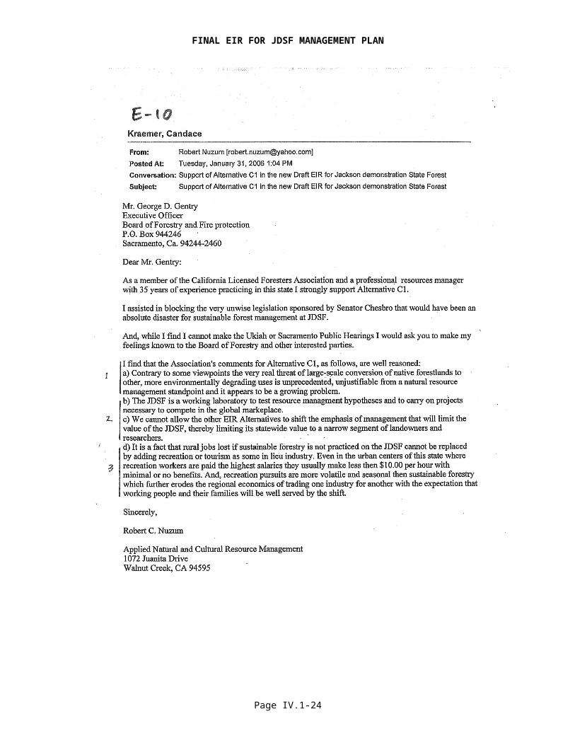
Email Letter E-10
Response to Comment 1Please see response to comments in DEIR mailed comment letter P-6.
The Board recognizes the continuing and increasing pressures of land use conversion and the environmental degradation associated with the problem. The Board further recognizes the role of sustainable, economic forest management for maintaining natural land cover. The California Timberland Productivity Act of 1982 (PRC 51102) establishes as one of its goals to “discourage premature and unnecessary conversion of timberlands to urban and other uses”. The management plan will continue the tradition of a working forest landscape that serves to demonstrate viable and sustainable forest management. It is hoped that by demonstrating economic alternatives to land use conversion this problem can be reduced.
Response to Comment 2The JDSF management plan will maintain a viable outdoor laboratory by managing the Forest to create diverse stand and habitat types (see General Response 2). The ADFFMP places increased emphasis on the Research and Demonstration mandate. The legislation that provided for establishment of the State Forest system makes it very clear that demonstration of economic forest management and maximum sustained production of high quality timber products is one of the primary purposes of JDSF.
Response to Comment 3The Board recognizes the importance of a diversified economy in the region, including timber. See Section III of the DEIR for a detailed discussion of regional economic impacts. See also General Response 14.
Page IV.1-24
FINAL EIR FOR JDSF MANAGEMENT PLAN
Page IV.1-25

FINAL EIR FOR JDSF MANAGEMENT PLAN
Email Letter E-11
Response to Comment 1See General Response 2. JDSF will remain a redwood forest. The ADFFMP establishes a high degree of protection to all of the associated resource values, including wildlife. One of the primary goals of the JDSF Management Plan is to achieve net improvements of conditions for all natural resources over time in comparison to existing conditions. The current plan is based on a monitoring and adaptive management feedback system. Goals are set for desired future conditions and monitoring is utilized to provide feedback regarding the effectiveness of management strategies in achieving those goals. Subsequent management actions will be modified as necessary to insure that resource conditions are on the correct trajectory to meet the stated management goals. The management plan represents state of the art management practices and implementation is not expected to produce significant adverse environmental impacts (see General Response 6, 10 and 11)
Response to Comment 2See Form Letter 6/6A Response to Comment 2
Response to Comment 3See General Response 2. Qualified support of Alternative F noted. The likely result of further restricting the economical management of redwood forests would be to cause private holdings to be converted to other land uses, such as residential housing. Economic pressure to convert expensive redwood forest properties to other land use is ongoing and the desire to preserve redwood forests by further regulating timber production must be balanced with this reality. The Board recognizes the value of JDSF to reduce this trend, and the inherent environmental degradation, by providing demonstration of viable and sustainable forest management.
Page IV.1-26

FINAL EIR FOR JDSF MANAGEMENT PLAN
Page IV.1-27

FINAL EIR FOR JDSF MANAGEMENT PLAN
Email Letter E-12
Response to Comment 1The Board agrees that JDSF is well suited to demonstrate restoration. The ADFFMP has placed greater emphasis restoration, with the goal of improving all resource values. The management plan includes an accelerated Road Management Plan, higher levels of aquatic habitat protection, and plans for continuing research and demonstration of alternative methods to control invasive plants (see General Response 7, 11, 13, and 15).
Response to Comment 2The Board does not control the operating budget for the forest. However, the Board supports the concept that the Forest be self sufficient, and develops sufficient funding to enable full implementation of the management plan. The management plan includes some expansion of the recreation opportunities, but economics of adding recreation based employment are not expected to replace timber based employment (see General Response 14).
Response to Comment 3See Response to Form Letter 6/6A.
Page IV.1-28

FINAL EIR FOR JDSF MANAGEMENT PLAN
Page IV.1-29
FINAL EIR FOR JDSF MANAGEMENT PLAN
Email Letter E-13
Response to Comment 1Support for Alternative D noted. The comment does not provide evidence that the DFMP represents the implementation of “old, or irrelevant, models of timber harvest”. The ADFFMP represents state of the art management practices and implementation of the plan is not expected to produce significant adverse environmental impacts. See General Response 10, 11, 14, and 15.
Response to Comment 2See Response to Form Letter 2 and General Response 5.
Page IV.1-30
FINAL EIR FOR JDSF MANAGEMENT PLAN
Page IV.1-31

FINAL EIR FOR JDSF MANAGEMENT PLAN
Email Letter E-14
Response to Comment 1Forest management and the regulations associated with timber harvesting have continued to evolve over time, so research and demonstration of forest management practices retains its value for both timberland owners and regulatory agencies. Often the research and demonstration is aimed at developing new and improved management practices that either mitigate potential adverse environmental impacts associated with timber harvesting or aid in the development of desirable stand characteristics. Some examples would be: studying the effectiveness of retaining various habitat elements from the original stand to improve wildlife habitat when implementing even-age management; testing the effectiveness of various strategies to protect aquatic resources; and testing the use of different management techniques to accelerate the development of late seral stand characteristics. Private industry cannot be expected to implement experimental management practices and dedicate tracts of land to long term research.
CDF is currently developing a website to catalogue the research and demonstration projects and/or publications that have been developed on the State forests (http://demoforests.net/). The website is incomplete, but the intention is to provide a means to disseminate information, including data sets, regarding projects on the State forests. The commenter is encouraged to visit the website. This website will be moved to the main CAL FIRE website (http://www.fire.ca.gov/) in the near future.
Response to Comment 2The comment erroneously interprets the statement. While no harvesting has occurred, some limited management has occurred. The revenue from timber harvesting is utilized to fund other management activities. Therefore, absent harvesting, and the funding it provides, the other management activities have been limited.
Response to Comment 3The exact meaning of the comment is not clear, but it is assumed that the comment indicates that the DEIR does not adequately address the benefits associated with managing JDSF for the development of old growth in the context of the surrounding State parks.
The ADFFMP presents a workable approach to create and maintain multiple seral stages, along with important structural habitat elements. It preserves all existing old-growth groves, augmenting most of them to provide large, contiguous areas of older forest habitat. It provides for recruitment of late seral habitat in the Mendocino Woodlands Special Treatment Area, upper Russian Gulch, lower Big River, and upper Thompson Gulch, as well as along all Class I and II streams. See General Response 9. It also provides for a broad corridor of forest with the structural characteristics of older forest that extends from the west to the east and the north to the south. The Plan protects individual large old-growth trees and smaller residual old-growth trees with unique habitat attributes. See General Response 8. And it sets goals for increased structure retention of snags, downed logs, and large green trees and their associated biodiversity values. The management of JDSF is therefore expected to augment the “substantial benefits” of the preservation based management of the State parks by increasing the connectivity of late seral and older forest habitat.
Page IV.1-32
FINAL EIR FOR JDSF MANAGEMENT PLAN
Page IV.1-33

FINAL EIR FOR JDSF MANAGEMENT PLAN
Page IV.1-34

FINAL EIR FOR JDSF MANAGEMENT PLAN
Page IV.1-35

FINAL EIR FOR JDSF MANAGEMENT PLAN
Email Letter E-17
Response to Comment 1JDSF will not be sold off, converted to parks or residential housing, or set aside as a reserve. The legislation that provided for establishment of the State Forest system makes it very clear that demonstration of economic forest management and maximum sustained production of high quality timber products is one of the primary purposes of JDSF. The timber harvest level under the ADFFMP is based on providing a varied landscape with a set of forest structures designed to support a viable research and demonstration program rather than a goal of a particular level of production. This analysis has resulted in a planned average annual harvest level of approximately 20 to 25 million board feet. Please see General Response 16.
Response to Comment 2See General Response 14.
Page IV.1-36
FINAL EIR FOR JDSF MANAGEMENT PLAN
Page IV.1-37

FINAL EIR FOR JDSF MANAGEMENT PLAN
Email Letter E-18
Response to Comment 1The comment provides no evidence of over cutting on JDSF. Average annual timber harvesting has never exceeded average annual growth over the “last several years”. The timber harvest level under the ADFFMP is based on providing a varied landscape with a set of forest structures designed to support a viable research and demonstration program rather than a goal of a particular level of production. This analysis has resulted in a planned average annual harvest level of approximately 20 to 25 million board feet which is well below current growth. In addition, the commitment to monitoring and adaptive management will ensure not only that harvest does not exceed growth, but that other timber related resource conditions are on the correct trajectory to meet the stated management goals. Potential impacts to other resource values have been mitigated to “less than significant”.
Response to Comment 2See General Response 2, 8 and 9.
Response to Comment 3Support of Alternative D noted.
Response to Comment 4See General Response 7.
Response to Comment 5See General Response 10.
Page IV.1-38
FINAL EIR FOR JDSF MANAGEMENT PLAN
Page IV.1-39

FINAL EIR FOR JDSF MANAGEMENT PLAN
Email Letter E-19
Response to Comment 1Support for Alternative C1 and its inherent management flexibility noted.
Response to Comment 2See Email Letter E-10, Response to Comment 2. See also General Response 2 and 14.
Page IV.1-40
FINAL EIR FOR JDSF MANAGEMENT PLAN
Page IV.1-41

FINAL EIR FOR JDSF MANAGEMENT PLAN
Email Letter E-20
Response to Comment 1Support for Alternative C1 noted. The Board recognizes the important role that JDSF fills by demonstrating sustainable forest management practices for private landowners.
Response to Comment 2See Email Letter E-10, Response to Comment 1 and General Response 16.
Page IV.1-42
FINAL EIR FOR JDSF MANAGEMENT PLAN
Page IV.1-43

FINAL EIR FOR JDSF MANAGEMENT PLAN
Email Letter E-21
Response to Comment 1Please see General Response 2, 8, 9, 11, and 12.
Response to Comment 2Please see General Response 14 and 15.
Response to Comment 3Please see General Response 10.
Response to Comment 4Privatization of JDSF and its forest resources is not proposed.
Response to Comment 5The Board supports a balanced, multiple use concept that provides high levels of resource protection and sustained production of high quality timber products. The ADFFMP has placed greater emphasis on protection and restoration, with the goal of improving all resource values over time in comparison to existing conditions. Protection is provided to wildlife and plants, and significant impacts are not expected to occur. Please see General Response 2.
Page IV.1-44

FINAL EIR FOR JDSF MANAGEMENT PLAN
Page IV.1-45

FINAL EIR FOR JDSF MANAGEMENT PLAN
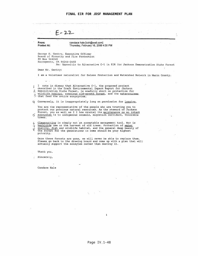
Email Letter E-22
Response to Comment 1See General Response 12.
Response to Comment 2See General Response 8.
Response to Comment 3See General Response 11.
Response to Comment 4See General Response 2.
Response to Comment 5The ADFFMP establishes a high degree of protection to all of the associated resource values, including old growth trees and wildlife. One of the primary goals of the JDSF Management Plan is to achieve net improvements of conditions for all natural resources over time in comparison to existing conditions. The management plan represents state of the art management practices and implementation of the plan is not expected to produce significant adverse environmental impacts. See also General Response 15.
Response to Comment 6See General Response 10.
Response to Comment 7See General Response 7.
Response to Comment 8See General Response 8 and 9.
Page IV.1-46

FINAL EIR FOR JDSF MANAGEMENT PLAN
Page IV.1-47
FINAL EIR FOR JDSF MANAGEMENT PLAN
Email Letter E-23
Response to Comment 1The Board agrees that it would be highly beneficial for the State Forest to fully resume management activities, so the Board is working actively to certify the EIR and approve a management plan. The Board recognizes that the lack of timber production in recent years has resulted in the loss of revenue for the State and the valuable programs that it supports. Forest practice regulation is no longer funded by timber revenue from the State forest system.
Response to Comment 2A significant level of sustainable timber production will continue at JDSF. A discussion of the economics of the timber industry is contained in Section III.5.4 of the DEIR.
Response to Comment 3Active management is required by the legislative mandate that created Jackson Demonstration State Forest. The Board supports a balanced, multiple use concept and sustained production of high quality timber products.
Page IV.1-48

FINAL EIR FOR JDSF MANAGEMENT PLAN
Page IV.1-49

FINAL EIR FOR JDSF MANAGEMENT PLAN
Page IV.1-50
FINAL EIR FOR JDSF MANAGEMENT PLAN
Email Letter E-24
Response to Comment 1Support for Alternative D noted. The timber harvest level under the ADFFMP is based on providing a varied landscape with a set of forest structures designed to support a viable research and demonstration program rather than a goal of a particular level of production. This analysis has resulted in an expected average annual harvest level of approximately 20 to 25 million board feet which is well below current growth. CAL FIRE has consistently harvested well below the growth of the forest, resulting in an ever increasing inventory of larger, older trees. In addition, the commitment to monitoring and adaptive management will ensure not only that harvest does not exceed growth, but that other timber related resource conditions are on the correct trajectory to meet the stated management goals. Taken as a whole, the implementation of the ADFFMP is expected to have many beneficial impacts to the overall forest health of JDSF.
Response to Comment 2The ADFFMP limits the use of even-age management to approximately 26 percent of the Forest (see General Response 2 and 10). Most of the remaining 74 percent of the Forest will be restricted to either no harvest or uneven-age management. Clearcutting is further restricted as described in General Response 10. The designation of 30% of the land base in the DFMP, and 26% of the land base in the ADFFMP, is designed to allow some flexibility when locating even-age silvicultural prescriptions. The area designated to allow the use of even-age management will include clearcutting and variable retention prescriptions, but will also utilize uneven-age management. The use of even-age management is not expected to result in significant adverse environmental impacts.
Response to Comment 3See General Response 7
Response to Comment 4See General Response 2, 8, 9, and 12.
Response to Comment 5The Board recognizes the importance of “good decisions made on the ground” when marking selection prescriptions. The Board further recognizes the advantages of this silvicultural method when properly implemented to reduce some types of potential adverse environmental impacts associated with timber harvest. The proposed management plan uses a set of structural goals to guide planned harvest actions. The central goal is not a particular level of timber harvest or a preferred method of harvesting but a set of forest structures that represent the full breadth of forest conditions. See General Response 2.
Page IV.1-51

FINAL EIR FOR JDSF MANAGEMENT PLAN
Page IV.1-52

FINAL EIR FOR JDSF MANAGEMENT PLAN
Page IV.1-53

FINAL EIR FOR JDSF MANAGEMENT PLAN
Page IV.1-54

FINAL EIR FOR JDSF MANAGEMENT PLAN
Page IV.1-55

FINAL EIR FOR JDSF MANAGEMENT PLAN
Page IV.1-56
FINAL EIR FOR JDSF MANAGEMENT PLAN
Page IV.1-57

FINAL EIR FOR JDSF MANAGEMENT PLAN
Page IV.1-58

FINAL EIR FOR JDSF MANAGEMENT PLAN
Page IV.1-59

FINAL EIR FOR JDSF MANAGEMENT PLAN
Page IV.1-60
FINAL EIR FOR JDSF MANAGEMENT PLAN
Page IV.1-61
FINAL EIR FOR JDSF MANAGEMENT PLAN
Page IV.1-62
FINAL EIR FOR JDSF MANAGEMENT PLAN
Page IV.1-63

FINAL EIR FOR JDSF MANAGEMENT PLAN
Page IV.1-64
FINAL EIR FOR JDSF MANAGEMENT PLAN
Page IV.1-65
FINAL EIR FOR JDSF MANAGEMENT PLAN
Electronic Comment E-25
Response to Comment 1 The DEIR and RDEIR are intended as a public disclosure and decision making tool to be used by the Board to analyze the significant potential effects arising from implementing the draft JDSF Draft Forest Management Plan (DFMP) and the Administrative Draft Final Forest Management Plan (ADFFMP), to identify alternatives, and to disclose feasible measures to reduce or avoid significant impacts. The lead agency, in this case the Board, is obligated to produce a comprehensive document that addresses the full range of potential significant environmental impacts in sufficient detail that a determination of significance can be made with regard to the proposed project and the alternatives. The size of the document is largely determined by the complexity of the potential effects of the proposed project, plus the alternatives, and the requirement of CEQA that the EIR adequately address those potential effects.
The DEIR is also responding to a judicial decision that required an expanded regional setting and cumulative effects sections. The DEIR is complex because it examines a number of complex issues. The use of existing studies is not an uncommon information source in EIR development. CEQA does not require the sole use of original research for alternative development and impact analysis.
Response to Comment 2The DEIR alternatives are described generally in the text, then explained in a detailed, comparative fashion in Table VI.1.
DEIR pages II-10 to -14 describes the programmatic nature of the DEIR and its relationship to future projects. The DFMP contains both general planning elements and specific proposed projects. The programmatic nature of the DEIR focuses on planning documents that generally contain a lesser level of detail than that found for an individual project. The DEIR examines a series of potential future projects that are geographically similar, carried out under the same authority, and have similar environmental effects and are mitigated in similar ways.
For the DEIR, spatial comparison of Alternatives was not conducted beyond the first decade given the speculative nature of the precise location of land management activities in space and time under any particular Alternative. Where supportable, spatial analysis was conducted using harvest units and prescriptions identified for Alternative C1 over the first ten year planning period. Retention or removal of Alternative C1 harvest units and/or change in harvest prescription was done for each Alternative to spatially characterize each Alternative for the Wildlife and Wildlife Habitat Analysis (See DEIR page VII.6.6-216 Spatial Pattern Analysis for Species of Concern). The DFMP included maps (figures 5 and 7) that illustrated attributes of Alternative C1. In the DEIR the spatial attributes for action alternatives were included (Map Figures D & Z) as well as the alternative with spatially unique attributes, (F) was included, (Map Figure AA.) The RDEIR included Map Figure 1 to illustrate Alternative G.
Response to Comment 3The comparison tables were developed to demonstrate similarities as well as differences between Alternatives. Consistent with CEQA guidelines, CAL FIRE evaluated a broad range of alternatives and used a matrix to summarize the differences among alternatives (Guidelines § 15126.6d). The impact levels used to characterize effects are required in environmental impact analysis reporting. While the check-boxes alone may appear to provide a somewhat coarse (but CEQA-compliant) ranking, the text within the tables provides finer-grained information about the performance of the various alternatives at addressing potential environmental impacts. Further discriminating information about the alternatives can be found in the text portion of the various impact analysis sections. That there are only relatively minor differences in identified impacts after mitigation and management measures are incorporated is a positive result and not an indication that significant
Page IV.1-66

FINAL EIR FOR JDSF MANAGEMENT PLAN
impacts were not identified or ignored. Alternatives that are at the extremes of the spectrum of management activities will exhibit clear differences. Management activities that are more conservative or closely related on the spectrum will exhibit differences that are less distinct.
Apparently, the commenter used the comparison tables to inform the very analysis conducted by the commenter to identify the “highest performing alternatives” thereby demonstrating the utility of the tables. There is no CEQA requirement that the proposed project be environmentally "highest performing" than any of the Alternatives; either before or after mitigations are applied. CALFIRE identified Alternative E as being the "Environmentally Superior Alternative" (DEIR page VI-13).
Differences in alternatives’ goals and values are compared clearly and in detail in DEIR Table VI.1, which runs some 38 pages. The impact comparison tables at the end of each resource analysis section clearly compare (with check-boxes and text) the impact differences among the alternatives.
Response to Comment 4The wide range of background information, varying at times in its detail or spatial comprehensiveness, is reflective of the information that was reasonably available for use in the DEIR. Taken as a whole, however, this information provides a robust picture of the aquatic resource conditions on JDSF, the larger watershed cumulative effects assessment area, and the broader regional setting. One intent of the DEIR was to provide the reader with a regional context that could then be applied specifically to considerations of JDSF. Threatened and endangered salmonids are of significant public concern. The Aquatic Resources section was arranged purposefully to respond to judicial direction to explicitly improve upon the setting section with additional information of a regional context. The section is arranged to examine the topics of habitat, populations, and the regulatory environment first at a regional scale, and then at the local scale of the JDSF ownership and adjacent ownerships. For example, section 6.1.2 provides a regional overview of aquatic habitat conditions followed by section 6.1.3 describing aquatic conditions within the JDSF ownership and by section 6.1.4 which examines aquatic conditions on adjacent watersheds and downstream areas. Similarly, section 6.1.6 examines salmonid population status in a regional context, followed by section 6.1.7 that examines fish distribution and status on JDSF proper. Finally, section 6.1.11 describes elements of the state and federal regulatory environment that guide JDSF management, followed by section 6.1.12 that describes specific regulatory and other specific management measures already incorporated in the JDSF management plan. Addressing aquatic resource setting issues at multiple scales for a programmatic EIR is clearly complex. That complexity was recognized early on and the DEIR aquatic resources section organized to minimize reader confusion. See also response to Comment 1.
Macroinvertebrate population composition and density is frequently considered as a measure of overall stream biological condition. That macroinvertebrates can be a useful indicator of overall stream condition is well known. However, one issue relative to their use for this purpose is the wide range of stream conditions occupied by species within the same family. The wide range of environmental conditions represented by macroinvertebrates that are not keyed to species and the general lack of macroinvertebrate data across JDSF and the cumulative effects assessment area led to the use of other metrics.
Response to Comment 5The commenter does not specify which topics have “important omissions,” making a reasoned response difficult. Regarding the specific examples provided by the commenter, they are recognized in the DEIR. The DEIR focuses on riparian shading as an important determinant of stream temperature because it is the principle driver that can be influenced by management activities. A comprehensive review of stream temperature is provided in Appendix 12 of the DEIR. This includes a discussion of the implications of the research presented by Bartholow (2000). Appendix 12 (page 1) specifically identifies upland vegetation as a factor in stream temperature. The Mattole River watershed has experienced a marked increase in acreage
Page IV.1-67

FINAL EIR FOR JDSF MANAGEMENT PLAN
converted to early seral stages of forest development since the 1940s. Accepting the hypothesis that ground-water temperature increases with the extent of early seral acreage, it is likely that project-associated effects would result in a decrease in ground water temperature on JDSF, since the proposed Administrative Draft Final Forest Management Plan will increase the area of later seral stages on JDSF. Site-specific results of extensive (>50% of watershed area) even age harvests specifically at JDSF in NF Caspar resulted in small, temporary increases in temperature that were within the tolerable range for coho salmon and steelhead (DEIR VII-6.34).
Regarding monitoring of hillslope conditions, stream channel conditions, stream temperatures, and fish and amphibian populations, Chapter 5 of the DFMP or ADFFMP provide further details, beyond the information provided in the DEIR, on monitoring plans for each of these areas and more.
Response to Comment 6The commenter is apparently basing his concerns and observations only on review of DEIR Section 6 (Biological Resources), and more specifically Section 6.1 (Aquatic Resources) as a stand alone watershed assessment. DEIR sections VII.7 (Geology and Soils), VII.10 (Hydrology and Water Quality), VIII (Cumulative Effects), Appendix 10 (Peak Flow Analysis), Appendix 11 (Sediment Studies), and Appendix 12 (Stream Temperatures), also provide important watershed analysis elements for JDSF and informed the evaluation of project impact. Given the complexity of watershed processes and aquatic ecosystem functions, it was necessary to both integrate and split the various resource analysis elements. The basic conclusion reached by the analysis and independent research reported in these sections is that aquatic conditions are not “continuing to degrade” but are improving and are expected to continue to do so.
Response to Comment 7The relative value of certain watersheds found on JDSF to the sustainability of coho in a regional context is acknowledged in the DEIR. The distribution of coho salmon is illustrated on DEIR page V-16 (Environmental Setting). Similarly, the value of JDSF as a provider of important aquatic habitat for coho and other species is noted on DEIR pages V-29 (Environmental Setting), VII.6.1-2 (Aquatic Resources), VII.6.1-31 (Habitat Suitability Overview), VII.6.1.53-64 (Regional Salmonid Population Status) and VII.6.1.85-87 (Critical Habitat). The commenter’s own GIS analysis (Strittholt et al. 1999) to identify focal areas for redwood ecosystem conservation was used in the DEIR and provides information on the relative condition and intact nature of JDSF watersheds in a regional context (DEIR pages V-26 to -29 and VII.6.6-26 to -28).
Another example of how the DEIR identifies watersheds with high value for fisheries is found in section VIII.7.1 of the DEIR. Here, a GIS model is used to identify watersheds with the best riparian habitat indicators and the lowest sediment delivery potential. This model provided one indicator of the watersheds within the cumulative effects assessment area with some of the best potential habitat conditions for salmonids.
In addition to the programmatic measures provided in the DEIR/RDEIR and ADFFMP, forest management activities that are conducted in a “stronghold watershed” or other area of recognized importance to salmonids would be provided protection on a site- and project-specific basis that may exceed programmatic requirements. These protections would be commensurate with the resource values requiring protection and would be determined following a detailed analysis of potential impacts. Project and site-specific management planning is part of a tiered approach to environmental review that will result in greater detail and identification of potential impacts and mitigation.
Response to Comment 8The commenter does not recognize the evidence provided in the DEIR analysis that ecosystem processes on JDSF and adjacent ownerships are in a state of recovery, and recovering at a rate that is greater than that added by expected future disturbance (Section VIII Cumulative Effects). That adding new stressors to already compromised systems results in a net negative is broadly
Page IV.1-68

FINAL EIR FOR JDSF MANAGEMENT PLAN
recognized where that system is in a state of decline. The aquatic environment on JDSF and surrounding ownerships is considered to be improving under current management. The degree of impact associated with new and added stressors was determined to be markedly less than the net effects of natural recovery processes and the application of proposed mitigation and management measures to protect and enhance aquatic values.
Response to Comment 9See response to Comment 7 regarding the programmatic nature of the DEIR. The California Environmental Quality Act (CEQA) provides direction regarding the examination of negative and positive influences of land management activities. The DEIR clearly addresses a broad range of resources that are potentially affected by timber harvesting and other management activities. One of the primary functions of the Demonstration State Forest is to examine the potential conflict between timber management and other resources.
The broad range of alternatives considered in the DEIR and the detailed analysis of their potential environmental effects provides a clear evaluation of the tradeoffs between various levels of forest resource utilization (e.g., annual average harvesting levels ranging from zero to 36 million board feet per year).
Response to Comment 10The central thrust of the comment appears to be the identification of the need for a monitoring and adaptive management approach for JDSF. Chapter 5 of the DFMP or ADFFMP provides information on the extensive monitoring and adaptive management approach for the Forest. This approach will provide the information needed to evaluate, over time, the changes in environmental conditions on the Forest, thus providing an opportunity to validate the environmental impact conclusions made in the DEIR and RDEIR. Where departures from anticipated environmental indicator values are found, steps will be taken to identify and address the causes for the departures. To the extent feasible, a GIS will be use to store, present, and evaluate the monitoring information that is collected over time.
The commenter does not articulate a specific concern regarding the need for “spatially explicit underpinnings for managing JDSF.” We do not believe that “spatially explicit underpinnings” are missing from JDSF management. The commenter’s contention that data must be spatially explicit to inform management decisions is not supported. The DEIR went to significant lengths to avoid the speculative interpretation of available data “that in all likelihood will later be found to be grossly inaccurate…” whether those data were spatial or non-spatial in nature.
With respect to the level of GIS-based analysis already included in the DEIR, see the response to Comment 2 and other comments below. Where spatial information existed and was not considered overly speculative, a spatial analysis of Alternative impacts was conducted. For example, see DEIR Pages VII.6.6-216-240 Spatial Pattern Analysis for Species of Concern and DEIR Pages VII.7.1-43 Geology and Soils.
Response to Comment 11For rare plants JDSF has both a GIS layer and list of occurrences on JDSF. CAL FIRE provides all new CNPS list 1& 2 occurrence information to CNDDB so that this information can be formatted in a standard manner and shared. JDSF has draft quality floristic lists for upland areas of the forest that could be affected by timber management. For individual projects the information has varied historically from full floristic lists to general descriptions. JDSF also maintains plant lists from several research projects focusing on plant occurrence and ecology.
Species survey requirements for plants are described in the RDEIR page II-38 and in the ADFFMP. The survey process will include pre-harvest qualitative surveys (DFG 2000 Protocol). Monitoring is also described in Chapter 5 of the ADFFMP.
Page IV.1-69
FINAL EIR FOR JDSF MANAGEMENT PLAN
Response to Comment 12 The definitions of the terms “late seral” or “late successional” are broadly recognized to include both mature and old-growth forests. Current “old-growth” forest stands are identified and mapped in the planning process. The late-successional development areas are described in the ADFFMP (Chapter 3): “Late seral stands are dominated by large trees and have multiple canopy layers, relatively few trees per acre, and substantial amounts of large, down wood”. In addition, individual old-growth tree characteristics are defined. “Late successional” or “late seral” as used in the ADFFMP when referring to late-seral development areas is meant to identify those forest stands that will be managed toward those conditions. The intent of the language used was, in part, to avoid confusion with current identified and mapped “old-growth” stands on JDSF that are recognized by the public.
It is not determinable what proportion of late seral (successional) stands would be considered “mature”, “over-mature”, or “old-growth” over the 100-year planning period and within the designated recruitment areas given the forest structure underpinnings of the terms definition and their related positions along the continuum of forest development-- although all of these forest conditions can be represented in the more general “late successional stage” of forest development.
The commenter discusses the broadly understood limitations of age as a basis for assigning forest acreage to a successional stage but then suggests that age is an important forest variable to map in order to evaluate Alternatives. Age is less important as an ecological variable than is structural condition (tree size, canopy closure, presence of special habitat elements etc.) in an assessment of ecological function. The latter was mapped and reported in detail which formed the basis for a habitat assessment by Alternative. The US Forest Service sought to identify ecological characteristics for a number of forest types in the early 1990s (US Forest Service. 1992. Old growth definitions/characteristics for eleven forest cover types. Pacific Southwest Region, California. Memo and report compilation from Regional Forester Ronald F. Stewart, Director, USDA Forest Service Pacific Southwest Experiment Station, to Forest Supervisors, Albany, CA. June 19, 1992.):
Successional stages are most often recognized by structural characteristics such as size of trees, distribution of tree sizes, presence and size of snags and logs, understory composition and heterogeneity, and horizontal diversity in structure. Late successional forests in general contain trees that are large for their species and the site, often a variety of tree sizes, large snags and logs, and a developed and often patchy understory. While the structural features of late successional forests, or old-growth, are generally recognizable, a myriad of community and ecosystem interactions (or functions) may also be diagnostic but are more difficult to measure and describe.… Stand age is often considered less important than structure in describing late successional forests because the rate of stand development depends more on environment and stand history rather than age alone.
Stand age can be roughly estimated from harvest history maps kept at JDSF. However, the results should be considered only as an estimation, because some relatively historic harvest operations were not mapped, and other non-harvest events that impact stand development (e.g. stand replacement fires) have not been recorded. The CWHR maps provide a better description of stand conditions than an age-based map.
Response to Comment 13The DEIR recognizes the regional conservation value of old-growth retention and recruitment and clearly describes the effort to meet this long-term management objective. The ADFFMP provides for:
Protection of all old growth groves and aggregations;
Page IV.1-70

FINAL EIR FOR JDSF MANAGEMENT PLAN
Creation of a contiguous 6,803-acre Older Forest Structure Zone, extending across much of JDSF from west to east and north to south, composed of older forest structure development area, old growth reserves, and late seral development areas;
Management of riparian zones on Class I and II streams for the development of late successional habitat and the recruitment and placement of large woody debris;
Upper Russian Gulch/Lower Big River (1,549 acres) designated as a late seral development areas for Marbled Murrelets and their habitat and
Designation of most the Woodlands Special Treatment Area (2,207 acres) for late seral development;
Overall, designation of one-third of the forest for maintenance or development of a range of older forest conditions.
Response to Comment 14The commenter may be confusing the application of two different habitat data sets. Table VII.6.6.1 is found in the Regional Setting section and uses the California Wildlife Habitat Relationships System (CWHR) to describe extent of habitat types. In order to provide a relative comparison of habitat types for JDSF and the region in general a common and regionally derived vegetation coverage was necessary. FRAP Veg was utilized for this purpose and reference to the mapping methodology used is noted in the footnote DEIR Page VII.6.6-2.
Table VII.6.6.18 describes the extent of CWHR habitat types on JDSF derived from vegetation mapping and forest plot sampling. The habitat type mapping completed at the scale of JDSF was used for alternative analysis and wildlife habitat relationship modeling. Locally derived data were utilized as the preferred option wherever possible.
Contrary to comment, CWHR was explicitly developed to be applied to areas of the size of JDSF and its larger assessment area. The limitations, benefits, and assumptions inherent in a variety of wildlife habitat relationship modeling tools were considered prior to application to alternative analysis. The CWHR was judged to be the best modeling system available to examine trend in habitat capability for as many terrestrial vertebrates as were likely to occur within the project area. As required, ancillary data and occurrence records specific to JDSF were also utilized to refine species occurrence outputs of the CWHR model.
CWHR is the most comprehensive wildlife information system for vertebrates in California today -- containing life history, geographic range, habitat relationships, and management information on 692 species of amphibians, reptiles, birds, and mammals known to occur in the state.
Development of the CWHR System started in the late 1970s. The California Interagency Wildlife Task Group (CIWTG) was formed in 1981 to provide guidance for system development, with a final Memorandum of Understanding (MOU) signed by sixteen total state and federal resource agencies and public universities in 1985. CIWTG continues to meet quarterly on scientific research and policy issues related to CWHR. The System represents nearly 30 years of work by wildlife biologists, vegetation ecologists, geographers, land managers and planners, computer programmers, Geographic Information Systems (GIS) analysts, statisticians, modelers, database managers, research writers, and wildlife artists working in a wide array of public and private organizations devoted to resource protection.
There are currently approximately 900 professional users of the CWHR System, representing biologists, environmental scientists, researchers, and land managers from public and private organizations throughout California.
The CWHR System is managed by professional biologists and GIS analysts in the Biogeographic Data Branch (BDB) within the California Department of Fish and Game (CDFG). BDB actively
Page IV.1-71

FINAL EIR FOR JDSF MANAGEMENT PLAN
acquires, integrates, improves, and distributes biological resource data sets in support of conservation needs. CWHR represents its most analytical tool, predicting species presence based upon geographic location and habitat conditions. It complements data representing wildlife sightings, such as the California Natural Diversity Database (CNDDB), because it predicts the presence of species in locations or habitats where they are likely occur but for many reasons have not been seen. Many species are difficult to detect and many places in the state have not been surveyed often for wildlife. A model such as CWHR can alert land managers to the potential presence of a species that may otherwise be missed in a resource assessment based solely upon wildlife surveys and databases of positive wildlife sitings.
The DEIR recognizes some of the complexities of using CWHR modeling, especially for late seral habitat. (VII.6.6-19).
Response to Comment 15See response to Comment 14. The CWHR model is clearly described as are important model assumptions. The comment does not suggest an alternative modeling approach that would provide more accurate results nor is it specific regarding the habitat or species predictive error that leads to an “extremely unreliable” conclusion.
Response to Comment 16The Board believes that non-spatial CWHR model outputs provide a reasonable assessment of trend in habitat capability (as derived from reproduction, foraging and cover requirements) for a wide range of species potentially occurring in the project area. The CWHR model considers all habitat types and stages used by the terrestrial vertebrate species expected in the project area. However, the Board recognized the inability of the CWHR model to explicitly report which habitat type and structural characteristics were primarily responsible for the modeled change in habitat capability and made model output adjustments to capture that information. Habitat type and structure changes responsible for marked change in species habitat capability are described for many taxa and for each Alternative.
CWHR is a non-spatial model and as such should not be expected to provide insight into a spatial evaluation of Alternative impacts. A spatial representation of habitat capability was developed using the BioView model described on DEIR Pages VII.6.6-219-221. See also response to Comment 17.
Response to Comment 17The limitations and assumptions associated with the spatial representation of Marbled Murrelet habitat are clearly described on DEIR Page VII.6.6-78-79 and Page VII6.6-238-239. This species requires very specific forest stand and individual tree characteristics that are not readily mapped or captured with the CWHR habitat classification system. It would be incorrect to assume that the species specific habitat issues identified by the commenter and reported in the DEIR for the potential Marbled Murrelet habitat map (Map Figure R) would also extend to the other species that were considered in a spatial context in the DEIR.
The following explanation can be found on pages VII.6.6-78 to -79 (Marbled Murrelet):
In addition to old-growth stands, other forest stands of various CWHR classes may provide suitable habitat in the form of single or small groups of large old-growth residuals. However, specific data is not available. Therefore, for purposes of this analysis, JDSF provides 459 acres of old-growth and numerous scattered residuals that are considered potential murrelet habitat (DFMP Appendix V, Table 2). The suitability for Marbled Murrelets would depend on the specific characteristics of the stand, including the presence of mature trees with large branches, deformities, and other formations that provide nesting platforms. For this analysis, these habitat types are used to represent potential habitat for
Page IV.1-72
FINAL EIR FOR JDSF MANAGEMENT PLAN
Marbled Murrelets, although it is important to recognize that many of these stands may not provide suitable habitat.
Recognizing the limitations of the CWHR system, and limitations associated with available survey for murrelets and other species, it is possible and even likely that some of the stands identified as being either suitable or unsuitable for any given species may not be correct. In the absence of field assessment and survey at the stand level, it is impossible to state with certainty that a given habitat area is suitable or not suitable. CAL FIRE may not "take" the marbled murrelet. Prior to the conduct of projects that propose to impact potential marbled murrelet habitat, an assessment of impacts must be conducted, including survey for the species. In the case of identifying potential future murrelet habitat for management purposes, it should be recognized that the assessment can serve only as a rough indication, and that further, more detailed analysis, is required at the project level.
Marbled Murrelets are known to nest inland at distances similar to that of James Creek in eastern JDSF. James Creek is approximately 17 miles inland and is similar to the greatest distance from the coast for 10 murrelet nests reviewed by Hammer and Nelson (17.34 miles) (See DEIR Page VII.6.6-75). However, the commenter is correct in the generalization that forest stand occupancy likely decreases with distance from the coast. This relationship is described in the Marbled Murrelet species account in the DEIR. Recovery Zone 5 that includes Mendocino County extends inland for a distance of 25 miles from the Pacific Coast.
The spatial pattern analysis conducted for species of concern did not utilize the FRAP Veg database as asserted by the commenter. JDSF Veg (2004) formed the basis for a distribution of CWHR habitat types for the analysis. JDSF Veg differentiates vegetation conditions to a greater degree than the habitat classification system and so cannot be used within the CWHR system to estimate the value of the habitat for various species. This is why the JDSF vegetation types were converted to CWHR habitat types. Map Figure 8 in the Draft Management Plan uses an older, less accurate vegetation coverage than that which was used in the DEIR (JDSF Veg 2004). Map figures J and K of the DEIR use the 2004 JDSF Veg for polygons within the forest boundary. Mendocino Redwood Company (MRC) vegetation polygons were used for MRC lands, and CALVEG was used for the remaining areas outside the forest boundary. It was CAL FIRE’s intent to use the best available data even though it originated from several sources. JDSF and MRC vegetation layers were used because they were created in 2004 by foresters using aerial photos and field surveys and were considered more accurate than remotely sensed data based on the older satellite imagery.
Response to Comment 18The habitat relationship model results from the CWHR System are considered the best available for the purposes of a programmatic DEIR. See response to Comment 14. CWHR produces a non-spatial characterization of habitat capability. BioView, a model developed by the California Department of Fish and Game, was used to illustrate habitat suitability for the eight species in a spatial context after consultation with the Department of Fish and Game. This model is described on DEIR Page VII.6.6-220 to -221 and a URL provided for additional information. There are limitations with any modeling approach. The model allowed an objective evaluation of the amount and configuration of habitat available under each alternative for each of the eight species.
Response to Comment 19CAL FIRE, after consultation with the Department of Fish and Game, selected 6 landscape measures to apply to each of the 7 Alternatives and for each of the eight species. The six measures were chosen for a variety of ecological and reporting considerations, including relative ease of understanding by the reviewing public. In addition, many of the FRAGSTATS metrics are highly correlated and the additional reporting of all FRAGSTATS metrics would not necessarily result in new or better information (DEIR page VII.6.6-28-33).
Page IV.1-73

FINAL EIR FOR JDSF MANAGEMENT PLAN
Response to Comment 20The Board used the best data available for a spatial assessment conducted at the scale reported. The degree that inputs to the Spatial Pattern Analysis for Species of Concern are “spatially coarse” and “largely unreliable,” as asserted by the commenter, is a species-specific determination.
That the spatial data generated are coarse is recognized. However, precise and spatially fine-grained analytical findings were not sought. The intent of the spatial analysis was to report the relative magnitude of differences between commonly used landscape metrics for each of the selected species under each DEIR Alternative. A key assumption, as indicated in the DEIR, was that all else being equal, a marked change in landscape metrics could, when viewed in the aggregate, indicate an important trend in habitat suitability as a result of Alternative implementation. Such a finding would require additional review of possible impacts and mitigation or management measure development..
Response to Comment 21The limitations and uncertainties of the modeling approach are described in detail on DEIR Pages VII.6.6-216 to -221, including mapping resolution, minimum mapping unit, and home range size. The commenter is not specific as to which species are not considered at the appropriate scale. The analysis does not assume that each species will respond in the same way as suggested by the commenter. Habitat suitability values are species-specific and derived from the reproduction, foraging and cover values a species finds for a particular CWHR habitat type and structure. The mapped polygon is then categorized as to suitability for that species. In other words, what is considered fully suitable for one species may be determined to be of low value for another species.
Response to Comment 22See response to Comment 19 and Comment 20. The DEIR followed a coarser more general analytical approach than that presumed by the commenter. The DEIR sought to examine for each species of concern the relative change in simple landscape metrics across all alternatives. The DEIR did not attempt to speculate on the ecological functionality of metric values derived for each species of concern by alternative beyond basic landscape ecology principles. For example, as described on DEIR pages VII.6.6-216 to -221, species preferring interior forest conditions and larger blocks of habitat closely spaced on the landscape would likely be better served by one alternative over another. Any alternative may well meet the spatial habitat requirements of a particular species over time, the objective of the analysis was to rank or group alternatives for each species using the metrics selected.
The relative ranking of alternatives as a result of the spatial analysis was summarized for the reader on DEIR Pages VII.6.6-237-240. This includes species-specific information. Habitat relationships for each species of concern were described in detail for each species of concern in the species accounts, DEIR Pages VII.6.6-44-110.
Response to Comment 23Individual planning units or watersheds were not used as the analytical landscape for a variety of reasons. First, for several of the species examined, individual home range and proportion of the landscape used by the population are not influenced by watershed boundaries. Second, conducting the analysis for each planning watershed by alternative and for each of the eight species of concern would have resulted in markedly more analytical effort and data of uncertain utility. Third, determining the spatial distribution of future THPs by watershed, beyond the first decade, and those silvicultural prescriptions to be applied is highly speculative. The result is a large number of possible management scenarios impossible to effectively analyze. The intent of the analysis was to provide a relative ranking of alternatives by the expected effect on widely recognized landscape metrics as guided by the habitat requirements for eight species of concern. The Board believes that the analytical objective was met.
Page IV.1-74

FINAL EIR FOR JDSF MANAGEMENT PLAN
Response to Comment 24 See responses to comment 20 and 22. No thresholds beyond the recognition of basic landscape ecology tenets were considered. Developing a threshold based on percent change in a particular metric would have been arbitrary. Note that comments 14 though 24 entail specific comments on analysis process. In responding to specific comments, the Board is attempting to explain the analysis process. Most comments do not suggest a specific flaw, rather set forth an opinion on a theoretically preferred analysis method. The comment provides no factual basis to assume that the Board failed to use adequate data inputs or analysis processes. Any analysis can only be legitimately conducted to the level of detail present in the initial data. The Board has recognized that fact, and has cautiously modeled and analyzed potential impacts.
Response to Comment 25The JDSF DEIR and RDEIR follow the CEQA Guidelines by providing a discussion of cumulative impacts of a project (the JDSF management plan) that is both comprehensive and rigorous. The CEQA guidelines state that the discussion of cumulative effects should be “guided by standards of practicality and reasonableness, and should focus on the cumulative impact to which the identified other projects contribute rather than the attributes of other projects which do not contribute to the cumulative impact” (15130b). The DEIR and RDEIR provide listings and discussion of all past, present, and probable future projects that potentially contribute to cumulative effects, which is considered one of the necessary methods for an adequate discussion of significant cumulative effects [15130 (1a)]. In addition, following the Dunne report (Dunne et al. 2001) the DEIR uses spatially specific models to evaluate aquatic habitat conditions and potential cumulative impacts from timber harvesting, roads, water flow, and water temperature (DEIR pages VIII.66 – VIII.72; Appendix 10).
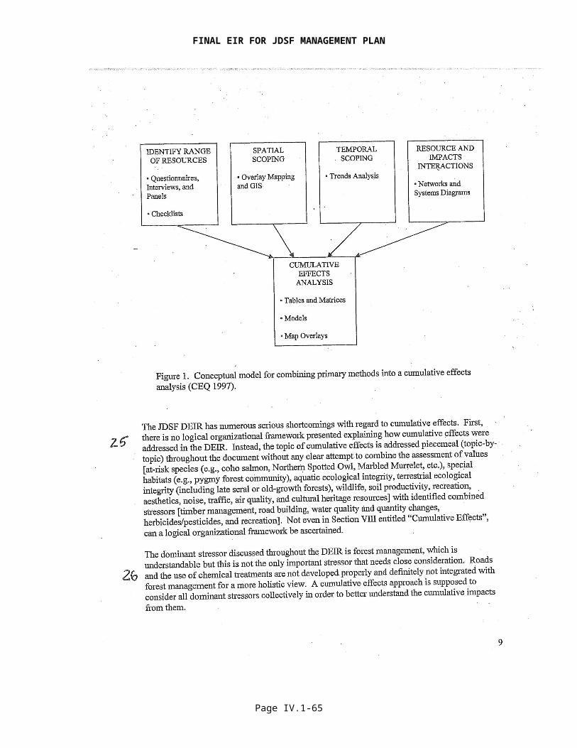
The DEIR and RDEIR provide discussions of cumulative effects in multiple, appropriate places throughout the documents. Cumulative effects are addressed in a number of the individual resource analysis sections, as well as a single section that deals entirely with cumulative effects (Section VIII in the DEIR and Section IV in the RDEIR). Sections of the DEIR and RDEIR that address cumulative effects can be readily identified in the table of contents. Some cumulative effects issues are crosscutting: For example, how do sediment, stream temperature, nutrients, flow, and large woody debris combine to affect in-stream fish habitat? Such issues are appropriately addressed in integrative sections like VIII in the DEIR and IV in the RDEIR. Other cumulative effects issues are more focused on how a single impact type may accumulate over space and time, such as loss of a particular habitat type and its impacts on a species that prefers that habitat (e.g., needs of Marbled Murrelets for trees, typically old growth, with large platform branches to provide nesting sites). This kind of focused impact can be appropriately contained within a section addressing wildlife and wildlife habitat.
As a detailed example of integration of crosscutting cumulative effects in the DEIR, Section VIII.4 addresses in one place the five important “watershed products” that are the key factors for in-stream fish habitat. These are the five factors that are most often influenced by forest management activities.
Further integrative analysis is found in the use of several models and large quantities of data in the cumulative effects section VIII.7.1, Aquatic Resources, of the DEIR. For an example of how the DEIR uses a model to integrate across multiple cumulative impacts, see the discussion of Model 1: GIS Evaluation of Cumulative Watershed Effects and Recovery Potential (DEIR page VIII-66 et seq.). This model integrates the following factors across planning watersheds within the JDSF cumulative effects assessment area and yields an aquatic habitat recovery score that provides an integrated indictor of cumulative effects:
Structure of riparian forest stands; Riparian shade; Channel characteristics; Road sediment;
Page IV.1-75

FINAL EIR FOR JDSF MANAGEMENT PLAN
Density of road and stream crossings; Riparian road density; Stream temperature; and Timber harvesting history.
This integrative analysis in Section VII.7.1 also includes the use of the EMDS model (see Comment 29).
The table at the end of the cumulative effects section in the RDEIR, Table IV.2. Summary of Potential Adverse and Beneficial Potential Cumulative Effects, provides a thorough overview of the results of the cumulative effects analysis and the broadly-encompassing range of factors (both individual and integrative) examined. The results shown here indicate that Alternative G, the basis for the ADFFMP, would provide a large number of significant beneficial cumulative effects and no significant adverse cumulative effects.
The DEIR and RDEIR make it clear when they are addressing cumulative impact issues. When addressed in single resource area sections, cumulative impacts are typically addressed after individual impacts. Further, the impact summary sections provided at the end of the executive summaries of DEIR and RDEIR, at the end of each resource analysis section, and at the end of the cumulative impacts sections all clearly identify where cumulative impacts have been identified in the analysis.
The comment suggests that every individual impact combines with every other individual impact, resulting in an implied matrix of myriad interactions. No models exist to evaluate such a matrix. Further, interactions of impacts are in reality more limited than this. The DEIR identifies where meaningful impact interactions occur and addresses the potential for those impacts to be significant. For an example of a simple interaction, the discussion of Marbled Murrelet identifies that recreational use in areas in or adjacent to the seabird’s habitat can be problematic because the food waste that recreationists often leave behind attracts corvids that also prey on Marbled Murrelet eggs (see DEIR Table VII.6.6.34, page VII.6.6-246). An example of more complex interactions is the GIS Model 1 discussed a few paragraphs above.
Response to Comment 26The comment notes that “the dominant stressor discussed throughout the DEIR is forest management.” Forest management broadly encompasses virtually all land use on JDSF and the other portions of the designated cumulative effects assessment area. Forest management includes roads (their construction, use, maintenance, upgrading, removal, etc.) and the use of chemical treatments to control vegetation. Both of these areas of forest management are thoroughly addressed and evaluated in the DEIR and RDEIR. The RDEIR finds no significant adverse impacts, cumulative or individual, that would result from Alternative G.
Forest management also includes the use of forests for recreation, gathering of minor forest products, protection of cultural resources, restoration, monitoring, collection of information about resource conditions, fire protection, and many more items. All of these forest management elements and others are thoroughly addressed in the DEIR and RDEIR. The comment does not specifically identify any relevant stressor that the DEIR or RDEIR has failed to address adequately.
Response to Comment 27The comment expresses a simplified view of roads, road density, and associated impacts that does not reflect the variability of forest conditions. For example, while two separate watersheds may share the same road density, one may have much greater potential for impacts to watershed resources, due to the type, maintenance, and location of the roads that exist. A given length of road constructed with little excavation, located on a gently sloped ridge does not share the potential for impact of a similar length of old road constructed in the inner gorge adjacent to a
Page IV.1-76

FINAL EIR FOR JDSF MANAGEMENT PLAN
stream. An overarching consideration with respect to this comment is that fact that the ADFFMP proposes to implement an aggressive Road Management Plan that will reduce the mileage of potentially damaging roads on JDSF and reduce the sediment and hydrologic effects of the remaining roads. New road construction will follow modern construction and maintenance practices, and will be largely located on the upper slope away from watercourses. The Road Management Plan will thus reduce the current level of road-related environmental impacts, resulting in a long-term improvement of environmental conditions.
An overall average road density for JDSF of 6.0 mi/mi2 does not in itself present a problem for aquatic resources. The road density on JDSF is in fact generally less than for other ownerships within the cumulative effects assessment area. There is unlikely to be single road density threshold that is appropriate for all watersheds. Theoretic and simulation analysis suggests that road density is a poor measure of road-related sediment delivery to the stream network. (University of Washington 2000). While sediment is produced on all forest roads used in timber harvest operations, its delivery to a stream is a function of its distance to the stream. Separation of roads from streams is an effective means of reducing sediment delivery, and JDSF has an active road abandonment program for high risk roads located near streams. CAL FIRE is committed to identify sediment sources from roads and decommissioning roads that are no longer needed or pose high environmental risk.
The Board agrees that roads can have major ecological impacts on ecosystems. The DEIR rigorously identifies the Forest’s road network, to estimate its contributions to sediment production, to identify measures that will be taken to reduce road sediment, and to assess the likely effects of sediment on aquatic resources and water quality. The DEIR uses a much more objective, evidence-based assessment approach to roads and sediment than the approach that the commenter uses. In addition to reviewing the significant existing body of studies of roads and other sediment sources in the cumulative effects assessment area (see DEIR Appendix 11, Overview of Existing Sediment Studies Relevant to the JDSF EIR, which cites 55 studies and reports), the DEIR uses the widely accepted spatially explicit road sediment model “SEDMODL2” to estimate road sediment sources within the cumulative effects assessment area.
Section VII.7, Geology and Soils, presents the results of SEDMODL2 and other GIS analysis in a highly detailed fashion at the planning watershed level (see DEIR Tables VII.7.1 and VII.7.2, and Figure VII.7.1). The planning watershed level is a very robust level of spatial analysis for a programmatic EIR; for example, the planning watershed is the typical unit of analysis used for watershed cumulative impacts at the project level, such as a timber harvesting plan. The SEDMODL2 results are incorporated into the integrated cumulative impacts analysis model detailed in the response to Comment 25.
The comment expresses a specific concern that the road density information provided in DEIR Table VIII.6b is too coarse for meaningful analysis. DEIR Table VII.7.1 provides highly detailed road density information, and other road information, at the planning watershed, subwatershed, watershed, and cumulative effects assessment area level. Density information is provided for both JDSF and non-JDSF ownerships. From this table one can ascertain, for example, that road density on JDSF is generally less than for other ownerships within the cumulative effects assessment area.
The Board concurs with the stress the commenter places on the importance of roads along streams, since these roads can be very detrimental to riparian and aquatic ecosystems. As stated in the comment, sediment potential is not equal for all roads—roads within 200 feet of streams or near stream crossings have a much higher potential for sediment delivery than roads near ridgelines. Therefore, riparian road densities and crossing densities are a better index of potential impacts to streams and aquatic habitats than road densities for entire watersheds. DEIR Table VII.7.1 provides the same level of detail on riparian road miles as described previously for overall road density. Table VII.7.2 provides equally detailed information on road crossings. In addition to its use in assessing cumulative impacts, the detailed information in this
Page IV.1-77

FINAL EIR FOR JDSF MANAGEMENT PLAN
table also will be useful in helping to set priorities for implementation of the ADFFMP’s Road Management Plan. For example, watersheds with the highest road sediment risk will be inventoried first. Road segments identified during the inventory process as having the highest sediment potential will be treated first.
In addition to discussing current conditions with respect to roads (which the DEIR and RDEIR do thoroughly), it is critical that the CEQA analysis discuss how the proposed project would lead to changes—to the environmental good or detriment—in those existing conditions. The DEIR and RDEIR also do this. For example, it is anticipated that implementation of the ADFFMP and its Road Management Plan will result in a reduction in the miles of potentially damaging roads on JDSF. It will result in the proper abandonment (permanent closure of roads in a way that reduces long-term sediment production, maintains hillslope stability, and re-establishes natural drainage patterns) of some road segments and the likely construction of other road segments that pose a lower level of environmental risk. Remaining roads will be improved to reduce their sediment and hydrologic impacts. Overall, the road sediment impacts of JDSF will be reduced substantially as the Road Management Plan is implemented over time. The Road Management Plan is detailed in ADFFMP Appendix IV.
The DEIR and RDEIR find that, for Alternatives C1 and G, respectively, the proposed management, with application of identified management measures and mitigations, would have:
Less-than-significant individual or cumulative effects of sedimentation on listed aquatic species (DEIR Sections 6.1.16 and VIII.8.5; RDEIR Sections III.6.2 and IV.3);
Less-than-significant individual or cumulative effects related to violation of water quality standards or waste discharge requirements (DEIR Sections VII.10.9 and VIII.8.5; RDEIR Sections III.10 and IV.3);
Less-than-significant individual or cumulative impact on soil erosion or loss of topsoil (DEIR Section VII.7.6; RDEIR Section III.7).
It is anticipated that implementation of the ADFFMP will result in a net decrease in the total amount of potentially damaging road length and area on JDSF over time. This change will result in improvements in wildlife habitat conditions related to roads over time. We also note that road edge is a positive habitat value for some species. The DEIR discusses road related impact to habitat utilized by various terrestrial wildlife species (e.g., Cooper’s Hawk, Marbled Murrelet, Northern Spotted Owl, Sonoma red tree Vole, southern torrent salamander, tailed frog, foothill yellow-legged frog).
The DEIR includes a mitigation to Alternative C1 to address potential project impacts, including those from roads, to snag and LWD dependent species:
Mitigation 1Retain all snags within all timber harvest areas with the exception of snags that pose a fire or safety hazard, or are within the alignment of roads proposed for construction. The largest snags, including residual old-growth snags, should have priority for protection until the snag retention goals of the DFMP are met. (DEIR p. VII.6.6.131)
The commenter incorrectly speculates that roads significantly open the forest canopy and allow more light to reach the ground. This is an over-generalization. With the exception of main haul roads, forest roads are usually sufficiently narrow that the forest canopy closes above the road within a few years of construction. It is common industry practice to estimate no loss of growing space due to forest roads. The DEIR addresses the issue of invasive species at length. The Board agrees that the literature supports the contention that roads and roadside habitats can be invaded by a suite of exotic (nonnative) plant species, which may be dispersed by "natural"
Page IV.1-78
FINAL EIR FOR JDSF MANAGEMENT PLAN
agents such as wind and water as well as by vehicles and other agents related to human activity, and that they can adversely impact some terrestrial species (Gucinski et al. 2000). To reduce this impact, the management plan calls for implementation of an integrated weed management program (see ADFFMP Chapter 5 and DEIR sections VII.6.2 and VII.8). The risk of spread is expected to be reduced over time. Some important elements of the program will include shade management, maintenance of ground cover adjacent to roads, encouragement of revegetation by native species, and monitoring of new road segments. The DEIR and RDEIR examined and did not identify any potential significant effects related to invasive species.
Response to Comment 28See response to Comment 25 regarding organization and integration of cumulative effects in the DEIR and RDEIR.
We note, as described in the response to Comment 25, that the cumulative effects analysis in the DEIR and RDEIR point to a number of positive cumulative effects from the implementation of Alternative C1 or Alternative G (the ADFFMP), given the various management measures and mitigations applied. The fact that many beneficial effects would result reduces the need to utilize even more fine-grained or quantitative analytical approaches than the ones already applied. Where potential impact outcomes tend to be adverse, there is a greater need for fine-grained quantitative analysis that more precisely assesses whether various quantitative thresholds might be breached, leading to likely significant adverse impacts. Given that these circumstances do not exist with respect to the proposed JDSF management, the level of analysis conducted in the DEIR and RDEIR is more than adequate to assess potential cumulative adverse impacts. Further, existing models and reasonably available data are substantially limiting in permitting a more detailed quantitative analysis than that already provided in the DEIR and RDEIR.
The DEIR discussed quantitative threshold values in many areas, these include:
Air quality (see DEIR section VII.5); Stream temperature impacts on salmonids (see DEIR pages VII.6.1-15 et seq., VII.6.1-26
et seq., and Appendix 12); V* measurement of instream pool filling (see DEIR pages VII.6.1-21 et seq.); Turbidity impacts on fish (DEIR pages VII.10-7 et seq.); Flow effects (DEIR pages VII.10-4 et seq. and Appendix 10). Change in measures of species habitat capability. Existing snag densities and recruitment.
All items in this list of thresholds are potentially measures of cumulative effects, since each may represent an accumulation of effects within the ambient air, within a stream system, or forestland condition.
In many cases, models do not exist to specifically evaluate the effects of management activities on these parameters, especially at the level of a programmatic EIR. However, modeling used in the DEIR did specifically evaluate potential quantitative effects on stream flow, road sediment, and wildlife habitat,
The analysis made full use of the best available information and analysis methods. In addition to being limited by existing models and reasonably available data, the ability to fully conduct spatial analysis of potential effects over time is limited by the programmatic and long-term nature of the project and the EIR. It also is limited by the need to use a cumulative effects assessment area that includes substantial amounts of privately held land (77 percent of the 214,000-acre cumulative effects assessment area is owned by landowners other than JDSF, mostly private industrial timberlands). Retrospective and forward looking spatial information was used to the extent it was available (e.g., the short-term harvests identified for JDSF). Historical trends were used to generate projected average spatio-temporal relationships at the planning watershed level,
Page IV.1-79
FINAL EIR FOR JDSF MANAGEMENT PLAN
even if site-specific information was not available. For example, historical harvesting trends on non-JDSF lands were used as a predictor of future harvesting activities.
Dunne et al. 2001 state that computer models should be used to scientifically address cumulative impacts from different stressors, but no one has been able to actually develop and link all of these models for the necessary components in a comprehensive way. Perhaps the closest computer model we currently have for doing this work is NetMap, but this tool is not currently available since most of the JDSF assessment area has not been inventoried. See also response to Comment 29.
Response to Comment 29The cumulative effects analysis in the DEIR and RDEIR goes well beyond “cobbl[ing] together whatever could be found.” See responses to above comments 25, 27, and 28.
The Board and Department have experience in using the EMDS model in a collaborative context with the Department of Fish and Game and other collaborators (see, e.g., Walker et al. 2007). EMDS is used in the DEIR for the assessment of cumulative effects related to in-stream habitat quality (see DEIR pages VIII-73 et seq.). While the EMDS system has some advantages, EMDS is a sometimes elegant compromise between hard science and “arm waving.” Walker et al. note a number of limitations of the model, but state that agency scientists found it useful for the in-stream reach condition form it was used in the DEIR.
No one has yet moved beyond the largely conceptual level in the development of a convincing method for transparently and comprehensively analyzing or predicting cumulative watershed effects in a single, all-encompassing model. For example, Dunne et al. (2001) provide the conceptual framework for a comprehensive risk-based approach to cumulative watershed effects assessment. They describe that “The risk assessments would be made through spatially registered mathematical simulation of watershed processes, using recently developed methods of modeling and spatial data acquisition and processing,” (ibid. at p. 1). However, Dunne et al. describe 10 different legal, conceptual, information, knowledge, economic, and social impediments to achieving their assessment approach (ibid. at p. 54). They specifically note, “The implementation of the proposed modeling approach for predicting [cumulative watershed effects] will require a significant increase in our current state of knowledge, particularly of the linkages between physical watershed changes and their biological consequences,” (ibid. at p. 59). While some progress has been made against the impediments identified by Dunne et al., the current state of knowledge and data still falls far short of what is needed to achieve implementation of their recommended approach.
Cumulative effects analysis is commonly accomplished through approaches that fall short of scientific perfection, but that nevertheless provide a level of assessment adequate to meet the requirements of CEQA. By all accounts, scientists and practitioners are still searching for better analysis methods to measure and predict cumulative watershed effects. What is presented in the DEIR and RDEIR meets the requirements of CEQA and is adequate to ensure public disclosure and protection of the environment. Modeling environmental responses to management can take a variety of forms and levels of sophistication.
Response to Comment 30Chapter 5 of the DFMP or the ADFFMP provides the monitoring and adaptive management framework that the commenter suggests here.
Response to Comment 31The DEIR provides information about historical management at JDSF and within the broader redwood region. Section VII.6.3.1 provides quantitative information on timber harvesting from 1949 forward for JDSF, as well the North Coast region and Mendocino County. It also provides a qualitative description of the harvesting history on JDSF and for the region from the first Euro-American harvesting in the 1800s forward. For related historical information also see, e.g., DEIR
Page IV.1-80
FINAL EIR FOR JDSF MANAGEMENT PLAN
sections III.5 through III.6.3. Historical harvesting Information also is provided in Chapter 2 of the DFMP or ADFFMP.
The DEIR provides a general understanding of how older historical management has influenced current conditions. While information on harvesting prior to 1986 is not brought in detail into the data presentation, analysis, and discussion in the cumulative effects section, it is important to recognize that the current conditions within JDSF and the larger cumulative effects assessment area reflect older harvesting activity. Extensive presentation and use of information on current conditions within the cumulative effects assessment area occurs throughout the DEIR and RDEIR. This information on current conditions provides the baseline of information from which the potential for future cumulative effects can be assessed.
Historic harvesting on the Chamberlain Creek watershed, an area specifically identified in the comment, is briefly discussed on page VII.6.3-3 of the DEIR and in Chapter 2 of the DFMP and ADFFMP. Stream temperature issues and data are covered at length in the DEIR, including section VII.6.1 in the main body and in Appendix 12. For example, with respect to the stream temperature example the commenter used for Chamberlain Creek, Appendix 12 identifies in detail the various determinants of in-stream water temperature. Table 1 in the appendix focuses on land management influences on stream temperature. Given the land use and water resource use of JDSF and other lands within the cumulative effects assessment area, the most relevant factors for water temperature in the Chamberlain Creek watershed are removal of upland vegetation and riparian management that affects large woody debris or shade canopy. Appendix 12 (starting at page 6) has a section discussing logging history and water temperature. While this section does not discuss Chamberlain Creek specifically, it provides an overall understanding of logging history and the way it influenced streams in the area. Table 4 in Appendix 12 provides information on stream canopy for Chamberlain Creek and other JDSF streams. The table indicates that Chamberlain Creek has a high degree of canopy closure (which is significantly related to stream shading), and that 95% of the stream length has 70% or greater canopy (rated as “high” canopy coverage).
Upland vegetation removal and conditions also are factors for stream temperature, as mentioned above. Table VIII.3 in the DEIR shows that the Chamberlain Creek watershed has had just 50 acres out of 7,863 acres (or 1%) harvested since 1986. The harvesting done is identified as being of a type that only partially removes the forest canopy. Given the lack of recent harvesting, the current vegetation conditions should largely reflect the influence of the longer term-harvesting history for this watershed. Map Figures K in the DEIR and 2 in the RDEIR show information about current vegetation conditions in the Chamberlain Creek watershed. Map Figure K from the DEIR uses the California Wildlife Habitat Relationships System (WHR) of classification. It shows that the Chamberlain Creek watershed is predominantly Douglas-fir in WHR Class 4 (mean tree diameter of 11-24 inches), with significant areas of redwood in WHR classes 3 (mean tree diameter of 6-11 inches) and 4. Map Figure 2 from the RDEIR provides information on the number of trees per acre greater than 30 inches in diameter at breast height. It indicates that the Chamberlain Creek watershed is dominated by stands with 4 or fewer of these larger trees per acre; with the exception of the western edge of the watershed, which has stands with up to 15 larger trees per acre. These larger trees play an important role in habitat structure for wildlife, as well as for potential recruitment into streams as large woody debris to provide a key in-stream habitat structure element.
While the discussion above goes on at some length about the Chamberlain Creek watershed, it illustrates the high level of detail of information that is included in the DEIR and how that information is used to draw inferences about the relationships among past land use, existing vegetation, and habitat conditions.
Response to Comment 32Past research and professional experience have shown that limiting harvest to a certain percent of the basin per year to keep sediment levels or other impacts below a set level is too simplistic to
Page IV.1-81

FINAL EIR FOR JDSF MANAGEMENT PLAN
be a robust indicator of potential environmental impacts. The approach does not account for regional or watershed variability, harvest location, silviculture, yarding system, roading, etc., and assumes a direct causal mechanism between harvest and the magnitude of impact. In most cases, it is not the fact that trees were harvested, but how they were harvested, where on the landscape, methods of roading and yarding, degree of riparian protection, and other factors that determine the impact of a forestry operation (Beschta et al. 1995).
JDSF-specific research is relevant to the issue of rate of harvest and potential for watershed cumulative effects. On the North Fork of Caspar Creek, approximately 45 percent of the watershed was clearcut harvested in approximately three years for the purpose of answering these questions. Research conducted in the North Fork of Caspar Creek watershed began in 1985 and directly addressed cumulative watershed effects. Most of the logged units were cable yarded and new roads were built along the ridge lines (thus avoiding sensitive riparian areas). Nested watersheds with individual gauging stations measured sediment routing. None of the statistical tests performed on the sediment data revealed significant positive interactions that would indicate disproportionate disturbance effects at downstream gauging stations (Lewis 1998). In both pre and post-treatment, main stem gauging stations had higher unit area sediment loads than in the tributaries, which could reflect the greater availability of sediment stored in lower gradient reaches. The intensive level of timber management in the North Fork of Caspar Creek watershed also did not cause large changes in watershed physical or biological variables in this moderately stable geologic formation (Ziemer 1998, Lewis 1998, Cafferata and Spittler 1998, Nakamoto 1998, Bottorff and Knight 1996, Bawcom 2003). Ziemer (1998) states that “the effect of logging on stormflow response in Caspar Creek seems to be relatively benign. The resulting changes in streamflow do not appear to have substantially modified the morphology of the channel (Lisle and Napolitano 1998) or the frequency of landsliding (Cafferata and Spittler 1998).” The Caspar Creek results show that significant adverse hydrologic and geomorphic changes resulting from timber operations can be prevented by the application of mitigation and management measures such as those contained in the California Forest Practice Rules and embodied in the ADFFMP.
The Report of the Scientific Review Panel on California Forest Practice Rules and Salmonid Habitat (SRP Report; Ligon et al. 1999) looked at percentage-based harvest limitations and found agreement that, “it would be difficult to set specific limitations of percent harvest goal per decade due to the effect of confounding and, in some cases, mitigating factors, (page 67). The SRP did not find “any widely accepted methodology or program that quantifies the level of harvesting with either cumulative effects or flooding,” (ibid. at page 68). Despite such problems, the SRP suggested that a harvest limitation based on percentage of watershed harvested per decade should be considered for application on watersheds, pending completion of a watershed analysis. However, the DEIR provides a significant level of watershed analysis, thus largely eliminating the usefulness of a simple rate-of-harvest threshold.
Response to Comment 33See response to Comments 25, 27, 28, and 29. The DEIR uses a substantial quantity of spatial and nonspatial data and a variety of models and other analytical approaches to describe current conditions and assess how future actions are likely to affect those conditions and values of interest.
The discussion of cumulative impacts found in an EIR does not need to provide as great detail as for the individual project effects and should be guided by reasonableness and practicality (CCR §15130(b)). And, the sufficiency of an EIR is to be determined in light of what is reasonably feasible and not by the exhaustiveness of the analysis and review (CCR §15151). In that this is a programmatic EIR the degree of specificity is limited, with greater analytical detail provided in support of individual site specific projects prior to their approval (CCR §15146).
Cumulative effects analysis is commonly accomplished through approaches that fall short of scientific perfection, but that nevertheless provide a level of assessment adequate to meet the
Page IV.1-82
FINAL EIR FOR JDSF MANAGEMENT PLAN
requirements of CEQA and to ensure the protection of the environment. By all accounts, scientists and practitioners are still searching for better analysis methods to measure and predict cumulative watershed effects. What is presented in the DEIR and RDEIR meets the requirements of CEQA and is adequate to ensure public disclosure and protection of the environment at a programmatic level.
Response to Comment 34The ADFFMP provides a clear path to the improvement of ecological conditions on JDSF, and the analysis in the DEIR and RDEIR indicate that many beneficial ecological effects will result and that no significant adverse impacts will occur. These improvements will build on the many steps, documented in the DEIR, that have been taken in recent years to improve ecological conditions within the cumulative effects assessment area for JDSF. DEIR Table VIII.7 identifies 126 projects undertaken since 1991 to improve conditions related to stream sedimentation, fish passage, fish habitat, riparian restoration, or planning activities. While impressive, this list does not identify all such improvement projects.
Response to Comment 35The DEIR provides substantial information on the regional and local ecological context for JDSF (see, e.g., DEIR Sections III and IV, and each individual Resource Analysis section). The Board believes that the ADFFMP provides a viable approach to lead “the way through demonstration and education on how to return ecological integrity to a degraded forest landscape and still maintain a steady and reliable economic return.” Just one indicator of the fact that JDSF is already well along the road to demonstrating this ecological and economic balance is the simple fact that JDSF stands are so much better stocked than private timberlands in the North Coast region. Average timber volume on JDSF is greater than 40 thousand board feet (MBF) per acre; private lands in the region have an average volume of about 15 MBF/acre (Waddell and Bassett 1996). However, JDSF is public land, subject to a different set of constraints and management objectives than most private timberland holdings. None-the-less, JDSF management serves as a demonstration of sustainability under the appropriate set of conditions and management incentives.
References
Bawcom, J.A. 2003. Clearcutting and slope stability, preliminary findings, Jackson Demonstration Sate Forest, Mendocino County, California. In: S.L. Cooper, compiler, Proceedings of the 24th Annual Forest Vegetation Conference, Redding, CA, January 14-16, 2003. University of California Cooperative Extension, Redding, CA. 10p.
Beschta, R.L., J.R. Boyle, C.C. Chambers, W.P. Gibson, S.V. Gregory et al. 1995. Cumulative effects of forest practices in Oregon: literature and synthesis. Prepared for the Oregon Dept. of Forestry. Salem, OR.
Bottorff, R.L.; Knight, A.W. 1996. The effects of clearcut logging on stream biology of the North Fork of Caspar Creek, Jackson Demonstration State Forest, Fort Bragg, CA -- 1986 to 1994. Unpubl. Final Rept. prepared for the California Department of Forestry and Fire Protection, Contract No. 8CA63802. May 1996. Sacramento, CA. 177 p. Cafferata, P.H. and T.E. Spittler. 1998. Logging impacts of the 1970's vs. the 1990's in the Caspar Creek watershed. In: Ziemer, R.R., technical coordinator. Proceedings from the Conference on Coastal Watersheds: the Caspar Creek Story, May 6, 1998, Ukiah, CA. General Tech. Rep. PSW GTR–168. Albany, CA: Pacific Southwest Research Station, Forest Service, U.S. Department of Agriculture. P. 103-115.
http://www.rsl.psw.fs.fed.us/projects/water/caspar
Dunne, T., J. Agee, S. Beissinger, W. Dietrich, D. Gray, M. Power, V. Resh, and K. Rodrigues. 2001. A scientific basis for the prediction of cumulative watershed effects. The University of
Page IV.1-83
FINAL EIR FOR JDSF MANAGEMENT PLAN
California Committee on Cumulative Watershed Effects. University of California Wildland Resource Center Report No. 46. June 2001. 107 pp.
Gucinski, H., M.J. Furniss, R.R. Ziemer, and M.H. Brookes. 2000. Forest roads: a synthesis of scientific information. USDA Forest Service.
Klein, R. 2003. Duration of turbidity and suspended sediment transport in salmonid-bearing streams, north coastal California. Final Report prepared for the U.S. EPA, San Francisco under Interagency Agreement DW-1495553501-0. Redwood National and State Parks, Arcata, CA. 32 p.
Lisle, T.R. and M. Napolitano. 1998. Effects of recent logging on the main channel of North Fork Caspar Creek. In: Ziemer, Robert R., technical coordinator. Proceedings of the conference on coastal watersheds: the Caspar Creek story, 1998 May 6; Ukiah, CA. General Tech. Rep. PSW GTR-168. Albany, CA: Pacific Southwest Research Station, Forest Service, U.S. Department of Agriculture; 81-85.
Nakamoto, R. 1998. Effects of timber harvest on aquatic vertebrates and habitat in the North Fork Caspar Creek. In: Ziemer, Robert R., technical coordinator. Proceedings of the conference on coastal watersheds: the Caspar Creek story, 1998 May 6; Ukiah, CA. General Tech. Rep. PSW GTR-168. Albany, CA: Pacific Southwest Research Station, Forest Service, U.S. Department of Agriculture; 87-95.
Lewis, J. 1998. Evaluating the impacts of logging activities on erosion and sediment transport in the Caspar Creek watersheds . In: Ziemer, Robert R., technical coordinator. Proceedings of the conference on coastal watersheds: the Caspar Creek story, 1998 May 6; Ukiah, CA. General Tech. Rep. PSW GTR-168. Albany, CA: Pacific Southwest Research Station, Forest Service, U.S. Department of Agriculture; 55-69.
Ligon, F., A. Rich, G, Rynearson, D. Thornburgh, W. Trush. 1999. Report of the Scientific Review Panel on California Forest Practice Rules and Salmonid Habitat. Prepared for the Resources Agency of California and the National Marine Fisheries Service, Sacramento. 92 p. + 7 appendices.
McGurk, B. and D. Fong. 1995. Equivalent roaded area as a measure of cumulative effects of logging. Environmental Management 19(4): 609-621.
University of Washington. 2000. Sediment and road density reduction. College of Forest Resources, Forest Engineering and Hydrology Program. Fact Sheet No. 4. 2 p.
Waddell, K.L. and P.M. Bassett. Timber resource statistics for the North Coast Resource Area of California, 1994. Resource Bulletin PNW-RB-214. Pacific Northwest Research Station, USDA Forest Service, Portland, OR.
Walker, R., C. Keithley, R. Henly, S. Downie, and S. Cannata. 2007. Ecosystem management decision support (EMDS) applied to watershed assessment on California’s North Coast. In Standiford, R.B., G.A. Giusti, Y. Valachovic, W.J. Zielinski, and M.J. Furniss, technical editors. 2007. Proceedings of the redwood region forest science symposium: What does the future hold? Gen. Tech. Rep. PSW-GTR-194. Pacific Southwest Research Station, USDA Forest Service, Albany, CA. p. 25-34. Ziemer, R.R. 1998. Flooding and stormflows. In: Ziemer, Robert R., technical coordinator. Proceedings of the conference on coastal watersheds: the Caspar Creek story, 1998 May 6; Ukiah, CA. General Tech. Rep. PSW GTR-168. Albany, CA: Pacific Southwest Research Station, Forest Service, U.S. Department of Agriculture; 15-24.
Page IV.1-84

FINAL EIR FOR JDSF MANAGEMENT PLAN
Page IV.1-85
FINAL EIR FOR JDSF MANAGEMENT PLAN
Page IV.1-86
FINAL EIR FOR JDSF MANAGEMENT PLAN
Page IV.1-87
FINAL EIR FOR JDSF MANAGEMENT PLAN
Page IV.1-88

FINAL EIR FOR JDSF MANAGEMENT PLAN
Page IV.1-89
FINAL EIR FOR JDSF MANAGEMENT PLAN
Page IV.1-90
FINAL EIR FOR JDSF MANAGEMENT PLAN
Page IV.1-91

FINAL EIR FOR JDSF MANAGEMENT PLAN
Page IV.1-92

FINAL EIR FOR JDSF MANAGEMENT PLAN
Page IV.1-93
FINAL EIR FOR JDSF MANAGEMENT PLAN
Page IV.1-94

FINAL EIR FOR JDSF MANAGEMENT PLAN
Page IV.1-95

FINAL EIR FOR JDSF MANAGEMENT PLAN
Page IV.1-96
FINAL EIR FOR JDSF MANAGEMENT PLAN
Page IV.1-97
FINAL EIR FOR JDSF MANAGEMENT PLAN
Page IV.1-98

FINAL EIR FOR JDSF MANAGEMENT PLAN
Page IV.1-99
FINAL EIR FOR JDSF MANAGEMENT PLAN
Page IV.1-100

FINAL EIR FOR JDSF MANAGEMENT PLAN
Page IV.1-101

FINAL EIR FOR JDSF MANAGEMENT PLAN
Page IV.1-102

FINAL EIR FOR JDSF MANAGEMENT PLAN
Email Letter E-26
Overall Response to Comments in Electronic Comment E-26Many of the comments in this letter raise the issue of historic and recent land management practices as contributors toward the existence of significant cumulative environmental impacts today. These are important factors; however, it must be recognized that the intent of CEQA is the evaluation of the effects arising from proposed future actions relative to the baseline conditions that exist today, which by definition include the legacy of past practices. While the DEIR and RDEIR look extensively at the potential cumulative interaction of the past practices with proposed practices (i.e., the DFMP and the Administrative Draft Final Forest Management Plan), CEQA does not require future actions to mitigate for past effects. Nonetheless, the DFMP, Administrative Draft Final Forest Management Plan, DEIR, and RDEIR contain many elements that will contribute toward the recovery of environmental conditions within the watershed cumulative effects assessment area evaluated in the DEIR. The issue of recovery is discussed further below. Response to Comment 1The DEIR provides a thorough discussion of coho salmon and their use of habitat on JDSF (see Aquatics section VII.6.1). This section of the DEIR includes a discussion both of the regional setting for coho (VII.6.1-10 to -21) and the environmental setting within JDSF. This discussion largely consists of comparisons of habitat conditions both on and off JDSF (see, e.g., DEIR Figures VII.6.1.3 and VII.6.1.4 on p. VII.6.1-23). The proposed management plan does recognize the importance of habitat conditions provided on JDSF to coho salmon. The management emphasis of promoting late seral conditions in the WLPZ areas bordering Class I and Class II streams is intended to maintain and enhance aquatic habitat conditions. The Additional Management Measure for Large Woody Debris Survey, Recruitment, and Placement, provided in the DEIR, has the same goal. Over time these improving conditions are expected to contribute to recovery and are consistent with the Recovery Goals as stated in the Fish and Game Recovery Strategy for California Coho Salmon (DFG 2004, p. ES.2).
Response to comment 2The JDSF DEIR and RDEIR follow the CEQA Guidelines by providing a discussion of cumulative impacts of a project that is both comprehensive and rigorous. The CEQA guidelines state that the discussion of cumulative effects should be “guided by standards of practicality and reasonableness, and should focus on the cumulative impact to which the identified other projects contribute rather than the attributes of other projects which do not contribute to the cumulative impact” (15130b). The DEIR and RDEIR provide listings and discussion of all past, present, and probable future projects that potentially contribute to cumulative effects which, is considered one of the necessary methods for an adequate discussion of significant cumulative effects [15130 (1a)]. In addition, following the Dunne report (Dunne et al. 2001) the DEIR uses spatially specific models to evaluate aquatic habitat conditions and potential cumulative impacts from timber harvesting, roads, and water temperature (DEIR pages VIII.66 – VIII.72).
Response to Comment 3Public Resources Code (PRC) §21081.6 requires a lead agency to adopt a reporting or monitoring program designed to ensure compliance with the measures intended to mitigate project impacts. California Code of Regulations (CCR) §15097(b) goes on to explain that where the project is the adoption of a plan-level document the mitigation monitoring plan may consist of the policies included in the adopted plan. The final Forest Management Plan will incorporate all measures identified in the certified final EIR thus ensuring compliance during individual project implementation.
The JDSF Administrative Draft Final Forest Management Plan includes a Chapter 5, Monitoring and Adaptive Management.” The approach was developed to track critical ecosystem processes that are potentially impacted by management practices. Many of the management measures
Page IV.1-103
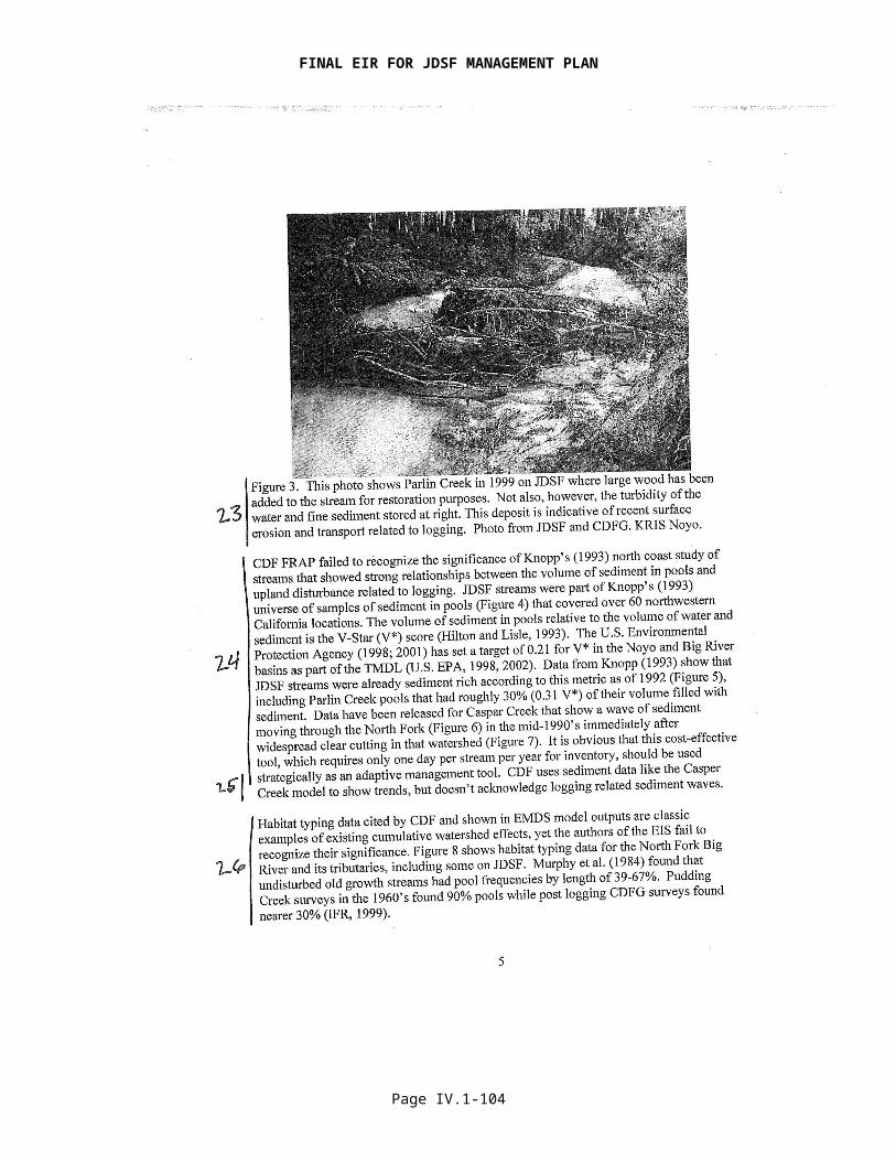
FINAL EIR FOR JDSF MANAGEMENT PLAN
described in the Administrative Draft Final Forest Management Plan and the mitigations and Additional Management Measures provided in the DEIR are designed to protect and mitigate potential impacts from management practices. Examples of this include the no-cut zones in WLPZ areas bordering Class I and Class II streams. In addition, any mitigation measures or monitoring requirements discussed in the DEIR and RDEIR are presented with the intention that they shall be implemented.
Further, CEQA emphasizes the application of mitigation measures when analysis indicates that there is the potential for significant adverse environmental impacts. Since the DEIR analysis found few potentials for significant adverse impacts for most of the alternatives, the DEIR needs to “emphasize feasible mitigation measures” only in a limited number of instances. Table I.2 in the DEIR (p. I-10 to -25) and Table I.1 in the RDEIR summarize the potentially significant impacts and proposed mitigations for the proposed project.
Response to Comment 4The DEIR and RDEIR provide a full CEQA programmatic analysis for the DFMP and Administrative Draft Final Forest Management Plan. They do not rely on the “functional equivalency” of the certified state regulatory program found in PRC §21080.5. Where later activities include timber harvesting, requiring the preparation of timber harvesting plans, environmental protection will be ensured through adherence to the Forest Practice Rules (FPRs) as well as compliance with the relevant sections of CEQA. However, the DEIR and RDEIR do not solely rely on the standard FPRs to mitigate the Plan’s cumulative or individual effects. Rather the DEIR and RDEIR identify specific activities where the FPRs or other management practices are not sufficient to prevent significant effects and require additional mitigation to lessen those impacts. For example, the DEIR identifies a potential for impacts to snag and LWD dependant species as a result of implementing the DFMP. As such, mitigation is required, that is in addition to the standard FPRs, which mitigates this impact (Page VII.6.6-131). Even where no potential impacts are identified, the DEIR requires additional Management Measures in certain instances to ensure protection of sensitive resources (e.g., Section VII.6.2.7, Additional Management Measures for Botanical Resources).
The Dunne Report does discuss limitations in the current framework for addressing cumulative effects, but it does so with the intent of improving the review of timber harvesting plans. Consistent with the Dunne Report, the DEIR, RDEIR, and the JDSF Administrative Draft Final Forest Management Plan are designed to reduce, not eliminate the risk of further impairment of environmental resources from timber harvesting. Additionally, while the Dunn report provides considerable commentary on perceived limitations with cumulative effect analysis included as part of THPs in the late 1990s, it suggests requirements to deal with cumulative watershed impacts that would require additional budgetary and regulatory authorities. Also, all of the comprehensive computer models suggested for addressing cumulative watershed effects prediction were not, and have not yet, been developed for this type of work.
Regarding the Collison report, conclusions included were made with the panel apparently unaware of provisions in the Forest Practice Act (FPA) and FPRs that give CDF the ability to require and enforce practices that protect water quality. This report also includes criticism of FPR sections that are restatements of legislative intent in the FPA and misconceptions about the THP review process, which indicates that the Panel did not have an adequate understanding of the legal framework for the preparation, review, and approval of THPs. Therefore, many of the criticisms found in Collison and others (2003) are already addressed in the existing THP process. Finally, regarding the Ligon et al. (1999) report, while the Scientific Review Panel concluded that the FPRs did not ensure protection of anadromous salmonid populations in 1999, the current rules in effect for JDSF have been considerably expanded with the passage of the July 2000 Threatened or Impaired Watersheds Rule Package and with the additional measures included in the DFMP, Administrative Draft Final Forest Management Plan, DEIR, and RDEIR. Further, the DEIR contains cumulative effects assessment approaches consistent with those recommended in Dunne et al.
Page IV.1-104

FINAL EIR FOR JDSF MANAGEMENT PLAN
Response to Comment 5See response to Comment 2 for a discussion on the adequacy of the DEIR to address cumulative watershed effects (CWE). Chapter 5 of the JDSF Administrative Draft Final Forest Management Plan provides a clear and well-defined monitoring program for the Forest. No monitoring plan or management plan could “guarantee positive trends in aquatic health or fish populations.” Rather, the monitoring program is designed to minimize the risk of further impairment and by design the Administrative Draft Final Forest Management Plan is expected to aid in recovery of fish populations. Monitoring is used in part to track progress towards a desired goal or future condition. If monitoring shows that resource conditions are deviating from the desired condition, then an adaptive management approach is used to make adjustments to the management plan (see Chapter 5 of the Administrative Draft Final Forest Management Plan).
Response to Comment 6Impacts from relatively recent clearcutting have been monitoring very intensely in the Caspar Creek watershed study—North Fork Phase and results have been described in depth in the DEIR as well as in numerous publications (Ziemer 1998, Lewis 1998, Lewis and others 2001, Keppeler and others 2003, Lewis and Keppeler 2004). In summary, the Caspar Creek results have shown that the impacts of clearcutting nearly half the watershed in three years were relatively benign and did not cause large changes in watershed physical or biological variables.
More broadly, Bawcom (2003) evaluated the amount of landsliding on 50 clearcut units throughout JDSF produced from 1982 to 1994. She found a total of 32 shallow seated landslides failed within the clearcut units. Of the 32 landslide failures, all but four were associated with roads, landings, and skid trails. Bawcom (2003) reported that these results suggest that there is little evidence that vegetation removal associated with clearcutting alone was a significant contributor to slope instability or reactivations of dormant landslides. Almost all of the observed landslides that delivered sediment to watercourses were shallow failures that were associated with old roads constructed decades ago. In general, this study found no increase in the rate of landsliding or initiation of movements of older landslides within clearcuts on JSDF.
Based on these two comprehensive studies conducted on JDSF, it is possible to conclude with assurance that relatively recent clearcut harvesting has not produced high levels of impacts to aquatic resources. Proposed harvesting under Alterative C1 or the proposed Administrative Draft Final Forest Management Plan based on Alternative G would treat much smaller percentages of watersheds than were treated by clearcutting in the North Fork of Caspar Creek.
Response to Comment 7The adequacy of an EIR is not determined by whether it “prove[s]” that a proposed action will or will not result in a significant effect but rather whether it discloses the potential for significant effects and identifies feasible mitigation. Two or more experts may reach completely opposite conclusions in interpreting the same information presented in an EIR, yet the EIR may still be deemed adequate. The courts will not attempt to determine if the EIR’s conclusions are correct as long as the decision that is reached is supported by substantial evidence.
The Board does recognize that timber harvesting and other forest management projects can incrementally contribute to pollutant loads, but the Administrative Draft Final Forest Management Plan has built in management measures to anticipate these incremental impacts and to reduce the impact to level that is less than significant. Further protections, such as the DEIR’s Additional Management Measure for an Accelerated Road Management Plan, have been incorporated into the Administrative Draft Final Forest Management Plan. The watershed analysis results presented in the DEIR and RDEIR also recognized that aquatic habitat conditions on JDSF and surrounding areas continue to improve over historic conditions.
Note also that the analysis performed for the EIR found that most of the aquatic system within the assessment area is in a state of recovery. Relatively small and well distributed incremental
Page IV.1-105

FINAL EIR FOR JDSF MANAGEMENT PLAN
effects are expected to occur, but these are not expected to prevent recovery or produce significant impacts.
Response to Comment 8The comment is non-specific and as such the BOF is unable to provide a detailed response. However, the BOF has attempted to address previous comments in the DEIR and RDEIR. Where appropriate, the BOF has provided references that further the discussion and analysis. The BOF believes that the significance and relevance of most references is evident, but without specific examples is unable to provide additional explanation.
Response to Comment 9Please see Response to Comments 17-21, below.
Response to Comment 10The DFMP, Administrative Draft Final Forest Management Plan, DEIR, and RDEIR include and clearly describe a variety of measures designed to protect and improve coho habitat quality based in large part on environmental risk factors identified in the California Department of Fish and Game Coho Recovery Plan and by the National Marine Fisheries Service Biological review Team. DEIR pages VII.6.1-90 through -98 lists other pertinent measures. These include but are not limited to an accelerated road management plan, WLPZ management to enhance late successional forest conditions and recruitment of large woody debris to stream ecosystem processes, measures to improve canopy cover and stream temperature, and provisions for providing extensive areas of late seral and older forest (over one-third of the Forest under the Administrative Draft Final Forest Management Plan).
Response to Comment 11Map colors were carefully chosen to illustrate the intended message of the various map figures. In some cases, due to the large number of classes of information the maps are intended to show, the level of distinction between colors/classes may have been somewhat difficult to discern.
Response to Comment 12As explained in the DEIR at page VI-9, Alternative B provides a baseline of recent past management direction against which the potential effects of the other alternatives can be compared. Management of JDSF under the 1983 Plan will continue until a new plan is adopted by the Board. The CEQA Guidelines [CCR 15126.6(e)(3)(A)] require an EIR to consider a “no project” alternative which discloses the impacts of continued management under an existing plan. While the alternative is “infeasible” in the sense that it is precluded by Board policy and the settlement agreement, it is still an alternative to the Plan that is useful in disclosing the environmental consequences of continuing current management practices.
Response to Comment 13The DFMP, Administrative Draft Final Forest Management Plan, DEIR, and RDEIR provide numerous protections that go beyond those explicitly enumerated in the Forest Practice Rules. These documents provide numerous protections that go beyond those explicitly enumerated minimum standards in the Forest Practice Rules. In addition, the Rules provide for an assessment of potential impacts, and the implementation of protection practices is not limited in any way by the Rules themselves. Protection provided by the DFMP, Administrative Draft Final Forest Management Plan, DEIR, and RDEIR includes:
Twenty-five-foot buffers along Class I and I streams where harvest is prohibited or limited to habitat improvement (DFMP/ Administrative Draft Final Forest Management Plan);
Watercourse and Lake Protection Zones are established as Special Concern Areas designated for special management to protect aquatic and riparian resources, maintain terrestrial habitat connectivity for wildlife, and promote development of late-successional forest stand conditions; silviculture is limited to no harvest or special uneven-aged regimes
Page IV.1-106
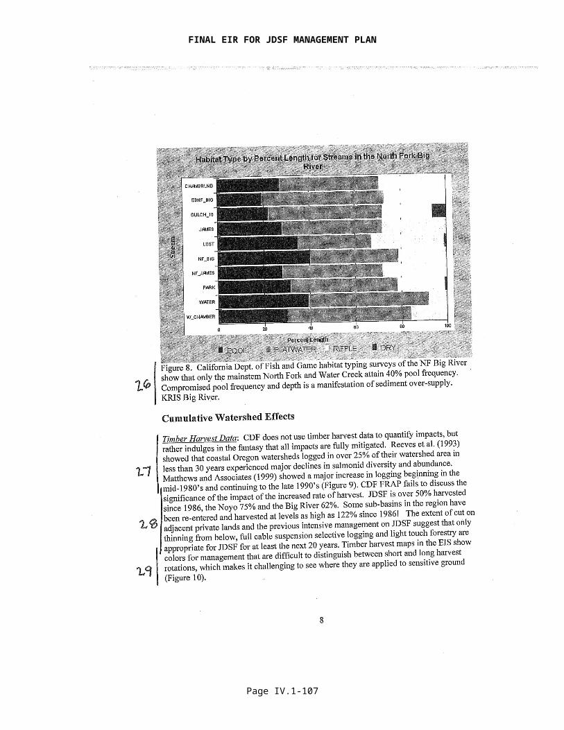
FINAL EIR FOR JDSF MANAGEMENT PLAN
designed to promote development of late-successional forest stand conditions (DFMP/Administrative Draft Final Forest Management Plan);
Retention of a minimum 240 ft2 basal area of conifers (DFMP/ Administrative Draft Final Forest Management Plan);
Road Management Plan (DFMP) and Additional Management Measures for Accelerated Road Management Plan (DEIR/ Administrative Draft Final Forest Management Plan);
Additional Management Measure for Survey, Recruitment, and Placement of Large Woody Debris (DEIR/ Administrative Draft Final Forest Management Plan);
Monitoring and Adaptive Management approach including hillslopes, stream channels, stream temperature, and fish and amphibian populations (DFMP/ Administrative Draft Final Forest Management Plan).
The comment related to Ligon et al. (1999), Dunne et al. (2001), and Collison et al. (2003) is addressed under the Response to Comment 4, above.
The analysis presented in the DEIR and RDEIR indicates that the proposed Administrative Draft Final Forest Management Plan will not result in significant adverse impacts to salmonids and that it will result in beneficial impacts to a number of important factors for salmonids, including water temperature, large woody debris recruitment, migration barriers, riparian forest quality and extent, and instream habitat and streambank stability (see DEIR p. VII.6.1-99 to -120 and Table VII.6.1.12; see RDEIR p. III-25 to -45 and Table III.6).
Response to Comment 14As noted in the DEIR (p. VI-9), Alternative A “…is not intended as an alternative that could feasibly be adopted; rather, it is intended as a baseline for purposes of comparing the project setting (and the absence of any management plan activities) to several different management strategies represented by Alternatives B through F.”
Response to Comment 15Alternatives C2 through E vary slightly to substantially from Alternative C1. Alternative G, which is the basis for the Administrative Draft Final Forest Management Plan, incorporates a number of the elements from Alternatives C2 through F that will provide an overall higher level of resource protection and recovery than would Alternative C1. Of particular relevance to this comment, the proposed Administrative Draft Final Forest Management Plan would designate over one-third of the Forest for the development of late seral or older forest characteristics.
As directed by (a) existing statues for JDSF and the Demonstration State Forest Program in general and (b) Board policies (see Appendix 5 of the DEIR), the Board must consider many other factors in addition to ecology when determining the appropriate management direction for JDSF.
Response to Comment 16
The DFMP documents that prior to the first harvest entries in JDSF beginning in the 1860s, most of the Forest was assumed to have been virgin old growth (see DFMP p. 6).
Response to Comment 17The DEIR analyzed data for a period spanning 1991-2003. However, the locations of the monitoring stations (or data loggers) have moved periodically, and thus not all locations have data for the entire duration that monitoring has occurred. The comment most likely refers to figures VII.6.1.6 and VII.6.1.8 in the Aquatics section that showed data for the time period 1995-2003. These figures are just two examples from the entire data set that was analyzed. The entire data set is provided in Appendix 12 of the DEIR. At the time that the NOP was issued (January 2004) stream temperature data from the summer of 2003 included the most recent observations.
Page IV.1-107

FINAL EIR FOR JDSF MANAGEMENT PLAN
Response to Comment 18Both of these areas currently support coho salmon (per DFG stream surveys), and shade levels are expected to increase as the trees within the riparian zone in these locations continue to grow and develop. Increasing shade levels are expected to result in lower water temperature.
The DEIR discusses the elevated temperature issues in Parlin Creek and along the South Fork of the Noyo (p. VII.6.1-29 and Appendix 12 p. 9, 12-14, 21). Valentine (1996) provides the most comprehensive study of stream temperatures in this specific location. The conclusions in his report suggest that conditions did not represent a serious cause of concern with regard to coho salmon. JDSF continues to monitor water temperature along the SF Noyo at the lower JDSF boundary. There were several years of decreasing temperatures since 1997 followed by two years of increasing temperatures recorded in 2004 and 2005 (see Table 1, below). With no timber harvesting during 2004 and 2005, changes in temperature likely represent natural variation. JDSF will continue monitoring at this location and modify management practices as needed.
Table 1. Stream Temperature Data SF Noyo at the lower JDSF Boundary (ID 25010). YEAR 1996 1997 1998 1999 2000 2004 2005MWAT 16.2 17.3 16.2 15.9 15.8 17.1 16.5Note that no data were recorded at this location between 2000 and 2004.
Response to comment 19The cautions noted by Collision et al (2003) are broadly recognized. The Board does not omit data to support or refute a stated hypothesis. See Response to Comment 8. The water temperature data that were analyzed, covering the time period 1991 – 2003, are provided as attachment A in Appendix 12 of the DEIR.
Response to Comment 20The Board is aware of historic water temperature data in this location. Detailed discussion of water temperatures on the South Fork Noyo can be found in DEIR Appendix 12, starting a page 12 and in the main body of the DEIR on pages VII.7.6-27 to -30. Stream temperatures recorded along the SF Noyo in 1997 did exceed optimal conditions for coho salmon, but as shown in Figure 5a the temperature decreased by a degree (Celsius) or more for the next three consecutive years. More recent data for this gauge site collected in 2004 and 2005 shows a slight increase, but still below the temperature recorded in 1997. With little or no management activity in the last several years the recent increase is not likely to be management related, but instead reflects temporal variability.
Response to Comment 21The DEIR analysis of turbidity included a range of thresholds from 40 NTU to 500 NTU (DEIR, Table VII.10.3). Table VII.10.3 reported all of the turbidity data provided in Lewis 2000. Recent field and laboratory studies have revealed that while the foraging efficiency of juvenile salmonids was decreased by increased turbidities, fish continue to capture prey at turbidity levels in the range of 40-50 NTUs (Hadden and others 2004). The value of the lower threshold is acknowledged and will be taken into consideration for future water quality monitoring. The Big and Noyo Rivers are listed as impaired for sediment, and suspended sediment concentrations are highly correlated with turbidity for a given watershed.
All data produced on JDSF are available to the public. Much of this data has been published or is available on the Internet. Any other data is available on request to CAL FIRE. CAL FIRE State Forest Program staff are continuing to make additional data sets available on the Internet over time, as funding allows.
Page IV.1-108

FINAL EIR FOR JDSF MANAGEMENT PLAN
Response to Comment 22The results from the Klein (2003) study are based on a small sample size and are not conclusive. In the report Klein states that the results are preliminary and in need of further replication. The implications from the study are discussed in the Cumulative Effects section of the DEIR (VIII-53). However, the need to collect additional turbidity data in other planning watersheds is a valid comment and will be given consideration as a research project or as part of the monitoring program, pending the availability of funding.
While it would be advantageous to install continuous recording turbidity monitoring stations in several locations throughout JDSF, the cost is prohibitive. It is unusual and highly beneficial to already have 21 continuous recording turbidity stations currently operating within the boundaries of a forest ownership the size of JDSF. Considerable amounts of suspended sediment and turbidity data exist from these South and North Fork Caspar Creek stations and were reported on in the DEIR in considerable detail.
Klein’s (2003) report suggests that there are thresholds of harvested acres beyond which additional harvesting will cause large increases in turbidity. Beschta and others (1995) write, however, in a comprehensive review of watershed relate cumulative effects, that natural systems rarely recognize discrete thresholds and can respond incrementally and interactively to change.
Additionally, Klein states in his report that that while turbidity levels might be decreased by reducing the density of roads in a watershed and limiting the annual rate of timber harvest, his “results should be considered preliminary and not be used alone for policy decisions or regulatory standards” (italics added). He also wrote that while his study argues for quantitative limits on annual harvest rates, they should be “perhaps customized to accommodate the variability in erosional sensitivity found within the northcoast. But a stronger analysis, one that includes a greater sample size of northcoast streams, is needed to establish defensible harvest rates that ensure protection of beneficial uses” (italics added).
Observing just the data from Klein’s (2003) paper collected on JDSF (the North Fork and South Fork Caspar Creek stations), the data show that the relationship described between increased harvesting rate and increased turbidity duration does not apply—the South Fork turbidity value is higher than the North Fork, even though the recent North Fork harvesting rate was higher. This outcome is likely explained by past roading practices and road abandonment work in the South Fork conducted in the late 1990s. Therefore, it appears from the data collected on JDSF that road construction, maintenance and abandonment practices are a very important factor to consider when discussing duration of turbidity—and more important than harvest rate.
Response to Comment 23The comment suggests that the source of the deposit seen in the photo is related to logging, but does not indicate how this determination was made. Natural processes such as landsliding and bank erosion can lead to similar sediment inputs to streams.
Response to Comment 24The DEIR discusses the significance of Knopp’s (1993) study in the Aquatics section of the DEIR (VII.6.1-18 to VII.6.1-24). The DEIR explicitly acknowledges that management activities have affected channel geomorphology on Class I and Class II streams (VII.6.1-104). As stated in the DEIR, Knopp’s results suggest that V* measurements for pools on JDSF are twice as high as undisturbed channels with similar geology (VII.6.1-104). More recent data reported by Stillwater for the draft 1999 HCP/SYP showed a much lower range of values for V*. The V* metric is very difficult to collect in a consistent fashion, which may contribute to the vast difference in V* numbers related to the same stream system. Most likely more consistent monitoring protocols are needed.
V* data also have been collected by the USDA Pacific-Southwest Research Station in the North and South Forks of Caspar Creek (Lisle and Napolitano 1998), and values from the early to mid-
Page IV.1-109

FINAL EIR FOR JDSF MANAGEMENT PLAN
1990s are generally similar to those reported by Knopp (1993). More recent values are lower, as displayed below in the following plot provided by Sue Hilton (USDA Forest Service, Pacific-Southwest Research Station, personal communication) in 2006 [note that data from Little Lost Man Creek (shown as “llm”), a reference watershed located in Redwood National Park is also included in this plot with the North Fork (“nfc”) and South Fork (“sfc”) of Caspar Creek]. Observe that there is a general decreasing trend for both forks of Caspar Creek over time.
Response to Comment 25CAL FIRE funded a very detailed study of sediment storage and transport in the South Fork Noyo River Watersheds (Koehler et al. 2001). The DEIR discusses the results in Appendix 11. The findings suggest that large amounts of historic logging-related sediment are stored in channels and transported downstream during high discharge events (DEIR Appendix 11, p. 3). Not much is known about sediment waves because they are difficult to observe and model and have highly variable behaviors (Lisle 1997).
Response to Comment 26 The DEIR does acknowledge potential cumulative effects, particularly from historic management practices. Language from the DEIR such as “Streams on JDSF lands may also be more advanced relative to their recovery and flushing of sediment than pool habitats in other streams that were studied,” (DEIR p. VII.6.1-22) and “A number of streams outside of JDSF within the Noyo Basin have pool frequencies below 20% (Figures VII.6.1.3 and VII.6.1.4), which may indicate a higher level of recovery in the streams of JDSF (Figure VII.6.1.2),” (DEIR p. VII.6.1-12), and “The habitat frequency chart from the North Fork of the South Fork Noyo within JDSF depicts some degree of recovery from past activities but pool frequency is still below the optimal range cited in the literature,” (DEIR p. VII.6.1-12), clearly indicate that the DEIR is addressing this topic from a cumulative effects perspective. Further, the DEIR states on p. VII.6.1-37, “Historic management practices and more recent (mid-1980s to mid-1990s) harvest levels in assessment
Page IV.1-110

FINAL EIR FOR JDSF MANAGEMENT PLAN
watershed areas (Noyo and Big River) and other adjacent watersheds (Pudding Creek, Ten Mile) at the regional scale may have contributed to the decline of salmonid habitat quality .”
Habitat typing data are presented and discussed in the DEIR Aquatics section (p. VII.6.1-18 to 24, and are further discussed in DEIR section VII.6.1.4 (beginning on p. VII.6.1-37).
Response to Comment 27 The cumulative effects sections of the DEIR and RDEIR rely on timber harvesting data from 1986 to the present to disclose and discuss potential impacts (see, e.g., DEIR p. VIII-4). Further detailed timber harvesting data, THP by THP, are presented in DEIR Appendix 14. The data in the DEIR are summarized by CALWATER Planning Watershed and by silvicultural system. Timber harvesting data also were used explicitly to evaluate and quantify hydrologic impacts related to changes in peak flows (DEIR Appendix 10).
The BOF, in evaluating the DFMP, did not find that “all impacts are fully mitigated”. Rather the BOF found a number of instances where implementation of the DFMP would lead to potentially significant effects and has required that measures to mitigate those effects be adopted. Further, it should be noted that CEQA is primarily concerned with the identification of potentially significant impacts and feasible mitigation. CEQA does not require that less-than-significant potential impacts be discussed in the same detail as significant potential impacts, nor does CEQA require that less-than-significant potential impacts be mitigated. We note, however, that the DFMP and DEIR contain numerous provisions that will avoid or mitigate both significant and less-than-significant potential impacts. Many of these elements with respect to aquatic species and their habitat have already been detailed in the Responses to Comments above.
The Reeves et al. (1993) article is of limited application to JDSF and the larger watershed area within which it lies. Oregon forest practice regulations during the 1985-1989 period examined in the article were less restrictive than those of California at the time, and were far less restrictive than today’s California Forest Practice Rules. California has had significant Watercourse and Lake Protection Zone rules in place since 1984, and those rules in place for the JDSF area were further strengthened with the implementation of the WLPZ rules for Threatened and Impaired Watersheds in 2000 (see the Forest Practice Rules at 14 California Code of Regulations § 916.9 et seq.)
There are several differences between the Oregon Forest Practice Rules and those enforced in California. While watercourse protection measures for fish-bearing streams have improved considerably in Oregon, major revisions to the Oregon Forest Practice Rules did not take place until September 1994. Oregon currently does not have buffer strip requirements that require conifer trees to remain post-harvest for non-fish bearing streams [the current Hinkle Creek watershed study in Oregon has as primary objective to determine the impacts of contemporary logging practices on non-fish bearing streams--with implications for the need for buffer strips on non-fish bearing streams]. Clearcut size in Oregon is limited to 120 acres [as compared to 20-40 acres under the California Forest Practice Rules (14 CCR §913.1)] within a single ownership. In many situations, a written plan is not required, only a 2 page notice of operation document is filed. Prior approval from the ODF before operations can begin and a written plan are only required for logging proposed in areas with a high potential for causing resource problems (operations within 100 ft of certain types of streams, high risk landslide sites, operations within 300 ft of areas identified as important sites for certain wildlife species, etc.) (Adams 1996).
The DEIR acknowledges that applicability of the Reeves et al. article also is limited by the different precipitation regimes and geology of the coastal Oregon basins examined by the authors as compared to the central Mendocino coast of California. There are considerable differences between trees species growing on JDSF and those found in the Oregon Coast Range in terms of slope stability. Sidle and others (1985) report that the influence of timber harvest on slope stability depends on the density of residual trees and understory vegetation, rate and type of regeneration, site characteristics, and patterns of water inflow after harvesting. In areas with
Page IV.1-111
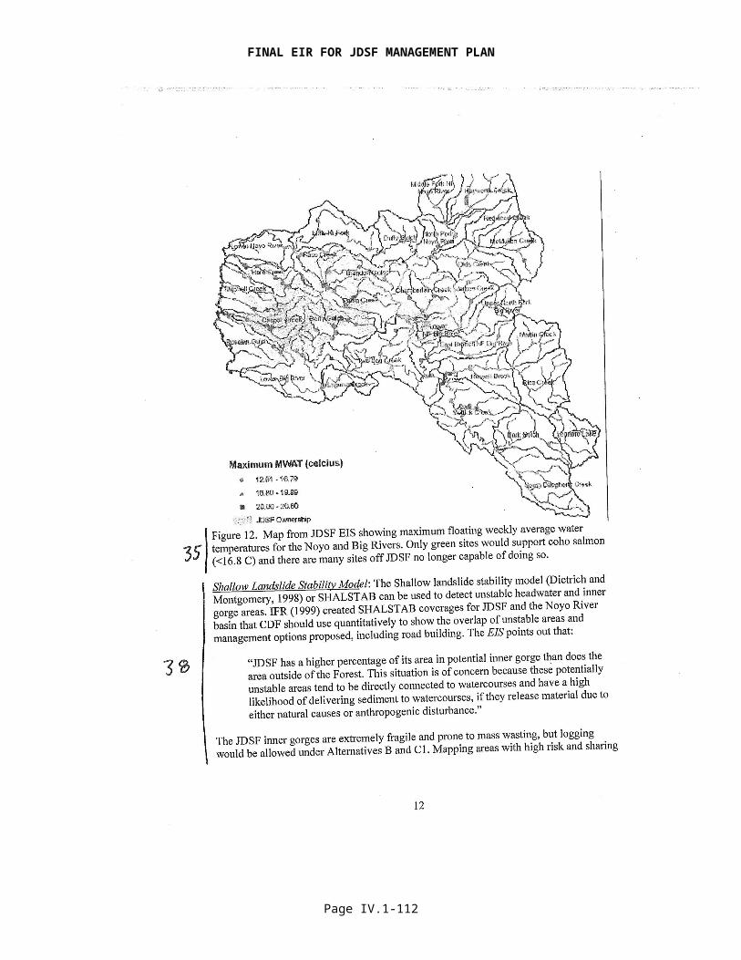
FINAL EIR FOR JDSF MANAGEMENT PLAN
marginal slope stability, loss of root strength and/or increased soil moisture from reduced evapotranspiration following logging can lead to an increased rate of slope failure (Sidle and others, 1985; Ziemer, 1981a). The influence of timber harvesting on slope stability depends on site characteristics (slope, geologic parent material, past landslide history), the tree species present, density of residual trees and understory vegetation, rate and type of regeneration, and size of storm events that occur after harvesting (Sidle and others, 1985).
Data collected to date in northwestern California areas with sprouting coast redwood does not show a clear relationship between clearcutting under the current FPR regime (sometimes in combination with requirements included in landscape level documents) and landslide rates. Most of the recent mass wasting features are related to roads and landings (Spittler and Cafferata 2004, Bawcom 2003). Improved Forest Practice Rules, mass wasting avoidance strategies, and requirements for professional input appear to be substantially reducing rates of mass wasting from northwestern California recent clearcuts. As stated in the above response to Comment 6, Bawcom (2003) examined rates of mass failures for redwood dominated clearcuts in western Mendocino County on Jackson Demonstration State Forest (JDSF). For this area, little evidence was found to indicate that vegetation removal associated with clearcutting alone conducted under the modern California Forest Practice Rules (1982 to 1994) was a significant contributor to slope instability or reactivations of dormant landslides. Almost all of the observed landslides that delivered sediment to watercourses were shallow failures that were associated with old roads (particularly low on the slope near watercourses) that were constructed decades before the recent harvesting. Similar conclusions were reached earlier for the North Fork of Caspar Creek on JDSF by Spittler (1995) and Cafferata and Spittler (1998).
In the Pacific Northwest, including the Oregon Coast Range reported on in Reeves and others (1993), where the tree species harvested do not sprout from the root mass, the period of increased landslide frequency after timber harvesting is elevated the most between the time of root dieback from harvested trees and the establishment of stabilizing roots by incoming vegetation (Swanson and Dyrness, 1975). This period of time is considered to be from 3 to 15 years after clearcutting (Sidle and Wu, 2001). For example in the slide-prone Mapleton area of the Siuslaw National Forest in the Oregon Coast Range, Ketcheson and Froehlich (1978, in Sidle and others, 1985) found a 3.5 fold increase over a 15 year period in the volume of debris avalanches and torrents in clearcut areas versus forested areas.
More recently in Oregon, Robison and others (1999) reported on the erosional consequences of two very large storm events which occurred in February andNovember of 1996 in western Oregon. Both storms resulted in a large number oflandslides, debris torrents, and altered stream channels. A three year monitoringproject was undertaken to evaluate the effects of the storms. The majority of theidentified landslides were not associated with roads, but were in clearcut units, withthe highest hazard area for shallow rapid landslides occurring on slopes of over70%. Data from this study indicated a higher incidence of landslides between 0and 10 years after clearcut timber harvesting (Spittler and Cafferata 2004).
Response to Comment 28The commenter is expressing an opinion regarding the extent of past impact, the level of impact associated with specific forms of stand management and timber yarding, and an associated period of time for which management should be confined to the specific form that he recommends. Further, the commenter has specified that only a single form of stand management should occur (thinning from below), while simultaneously specifying that selective logging and light touch forestry should occur. While selection logging may include some thinning from below, thinning from below is not synonymous with selective cutting, and "light touch forestry" is not a defined term. These comments represent over generalization that is not supported. The Board will not speculate as to why the commenter believes that future management should be limited as specified. In fact, the analysis performed for this EIR indicates that the watershed is in a state of active recovery from past impacts, and that this recovery will continue coincident with the
Page IV.1-112

FINAL EIR FOR JDSF MANAGEMENT PLAN
management that has been proposed. The proposed management includes a broad spectrum of individual stand management and timber yarding techniques, and each proposal to harvest timber will be accompanied by a site-specific analysis of potential cumulative effects.
The DFMP and Administrative Draft Final Forest Management Plan recognize the sensitivity of streams and riparian areas to potential management impacts and designate these as Special Concern Areas. As such, these areas have significant restrictions on management operations in WLPZ areas, as documented in number of the responses to comment above. Over time, the implementation of this plan should assist in the recovery of degraded channel conditions.
The JDSF DFMP, Administrative Draft Final Forest Management Plan, and DEIR, in part, use the results of the Stillwater-Sciences-produced watershed analysis work to identify approaches to reduce cumulative impacts to a level less than significant. Specifically, on-site impacts from individual and multiple projects will be reduced by a combination of the FPRs, added measures provided for in the DFMP, Administrative Draft Final Forest Management Plan, DEIR, and RDEIR, and site-specific measures added from the THP preparation process and Review Team agency review of THPs, as well as from pre-plan consultation with qualified experts. Repair of existing road-related sediment problems will be accomplished through the Additional Management Measure for an Accelerated Road Management Plan.
The rate of sediment production from new activities (i.e., from roads and harvest units) described in the DFMP is not expected to inhibit watershed recovery. The total amount of harvest-related sediment and the proportion of sediment production between harvest areas and roads vary depending on logging systems and road location, type, design, and use and with differences in planning watershed sensitivity. In general, there should be near recovery to original or new baseline suspended sediment conditions within approximately 10-20 years following harvest (Grant 2000). The hazard of sediment production from permanent roads can be considered as constant after about 10 years, although actual amounts will vary by road type and storm size–with less frequent, episodic inputs associated with large storms. Higher rates of surface erosion and failures due to poor design or execution are most likely during the first few years following construction.
Data provided in Table VIII.10 of the DEIR shows that the intensity of future harvesting on JDSF in the next 10 years will be less than has been tested in the North Fork of Caspar Creek, where approximately 45% of the watershed was clearcut harvested in three years. Research conducted in the North Fork of Caspar Creek watershed beginning in 1985 directly addressed cumulative watershed effects. Most of the logged units were cable yarded and new roads were built along the ridge lines. Nested watersheds with individual gaging stations measured sediment routing. None of the statistical tests performed on the sediment data revealed significant positive interactions that would indicate disproportionate disturbance effects at downstream gaging stations (Lewis 1998). In both pre and post-treatment, main stem gaging stations had higher unit area sediment loads than in the tributaries, which could reflect the greater availability of sediment stored in lower gradient reaches. The intensive level of timber management in the North Fork of Caspar Creek watershed also did not cause large changes in watershed physical or biological variables in this moderately stable geologic formation (Ziemer 1998, Lewis 1998, Cafferata and Spittler 1998, Nakamoto 1998, Bottorff and Knight 1996). The Caspar Creek results show that downstream water quality impacts of hydrologic changes resulting from timber operations can be prevented by the application of mitigation measures contained in the California Forest Practice Rules.
Also note that the anticipated amount and intensity of harvesting is less in the Administrative Draft Final Forest Management Plan than was proposed in Alternative C1. The Administrative Draft Final Forest Management Plan, or Alternative G, makes a smaller amount of the Forest available for evenaged management, designates over one-third of the Forest for development of late seral or older forest conditions, and places significant limitations on the acreage of evenaged management that can be conducted each decade.
Page IV.1-113

FINAL EIR FOR JDSF MANAGEMENT PLAN
Response to Comment 29See Response to Comment 7.1, above. The Board examined the specific map cited here, Map Figure Z, Silvicultural Spatial Allocation Plan, in both the printed version of the DEIR and in the PDF version [as downloaded from the Board website (http://www.fire.ca.gov/php/rsrc-mgt_content/downloads/jdsf_deir_05/DEIR_Map_FigureZ_SilviculturalSpatialAllocation.pdf) and viewed on computer screen]. While the map colors could have been more distinct, we were able to reasonably easily discern the different silvicultural systems displayed in the printed version of the figure. The on-screen image was less clear, but still distinguishable.
In the DFMP, the same figure is provided as Figure 7, Timber Management Areas. The printed version of Figure 7 in the DFMP has very clear distinction between the colors. The electronic version of Figure 7, as provided to the public via the Board of Forestry and Fire Protection website (http://www.bof.fire.ca.gov/pdfs/fig7.pdf) and on CDs, is somewhat more easily distinguishable than the DEIR electronic version of Map Figure Z.
With respect to the expressed concern about Brandon Gulch being designated for short-rotation silviculture, we note that Map Figure Z clearly shows that Brandon Gulch is allocated to unevenaged management (to which the concept of rotation does not apply), plus a Special Concern Area. Further, it should be noted that the silvicultural allocations presented in Figure Z are general designations. Additional information on slope stability (such as that shown and Map Figures V and W) and on-the-ground determinations of slope stability made by a licensed engineering geologist will be used to develop the actual silvicultural treatments provided on any specific area.
In the RDEIR, Map Figure 1 provides the equivalent spatial information on silvicultural allocations for Alternative G, as does Map Figure 5 in the Administrative Draft Final Forest Management Plan. The color scheme in these map figures is very distinctive. Under Alternative G and the Administrative Draft Final Forest Management Plan, management in Brandon Gulch would continue to be unevenaged.
Response to Comment 30Section 10.3.3 of the DEIR (p. VII.10-6 to -7) provides a discussion of the effects of timber harvest on flows, and Appendix 10 provides a lengthy and detailed discussion of this topic. The Aquatics section (VII.6.1) discusses the importance of flow as a habitat factor for fish.
The main body of the DEIR addresses roads and their effects on sediment detail in several places:
Section VII.7.2.4 (p. VII.7-7 to -19); Section VII.10.4.2 (p. VII.10.-7 to -10); Section VIII.3.1 (p. VIII-15 to -17); Section VIII.3.3 (p. VIII-39 to -40.
In addition, Appendix 11 focuses solely on the issue of sediment and contains extensive discussion and data related to roads and sediment.
Quantitative information on roads and sediment can be found in a number of places in the DEIR. See the following tables or figures and the related discussion:
Table VII.7.1 Table VII.7.2 Figure VII.7.1 Table VIII.6b Table VIII.7 (documents projects implemented to reduce road-related sediment) Appendix 11: Figures 2, 4, 7, 8; Tables 2 plus 4 attached tables.
Page IV.1-114

FINAL EIR FOR JDSF MANAGEMENT PLAN
Matthew’s sediment source area analysis work is discussed in the DEIR in Appendix 11. The DEIR analyzed the effects of roads on sediment yield. Sediment budget work completed by Stillwater Sciences for the draft HCP/SYP for JDSF was incorporated into the DEIR and is consistent with the work by Mathews in that they both recognize roads as a primary sediment source. Matthews’s estimates of sediment yield from roads by time period are an office-based assessment with little or no field validation. Through field-based inventory and prioritization, the Road Management Plan proposed in the DFMP (or the Additional Management Measure for an Accelerated Road Management Plan) provides a practical, proven approach to reducing sediment loads. This approach also is included in the Administrative Draft Final Forest Management Plan.
Response to Comment 31The BOF and CAL FIRE are committed to identify sediment sources from roads and decommissioning roads that are no longer needed or pose high environmental risk. However, there is unlikely to be a single road density threshold that is appropriate for all watersheds.
The Road Management Plan included in the DFMP and the Additional Management Measure for an Accelerated Road Management Plan provided in the DEIR are both indicative of the Board’s and CAL FIRE’s commitment to address road related impacts on ecosystems, including removal of roads. The Road Management Plan includes road abandonment as one of its elements (see DFMP Appendix VI). This approach also is included in the Administrative Draft Final Forest Management Plan.
Response to Comment 32Appendix 12 of the DEIR discusses a range of variables that can potentially influence stream temperature. Previous modeling studies by Bartholow (2000) found that shading and stream width were the most influential variables in determining stream temperature. The results from Welsh et al. (2005) do suggest that groundwater can play an important role in regulating stream temperatures during the warm summer months. The role of groundwater in regulating stream temperatures across JDSF is not well understood. It may be a useful research or monitoring project to consider if future funding becomes available. JDSF currently uses a well distributed network of stream gauges to monitor stream temperature and where stream temperatures are of concern management prescriptions are adapted as needed.
With respect to the findings of Welsh et al. and their relevance to JDSF, it is important to note the following:
Late seral stage vegetation types will be increased with implementation of the DFMP, in riparian areas in particular, and not decreased as occurred in the Mattole River basin cited by Welsh et al. Under the proposed Administrative Draft Final Forest Management Plan, over one-third of JDSF is designated for the development of late seral or older forest structure.
Welsh et al. (2005) determined that the primary processes influencing faunal assemblage patterns were vegetation changes resulting from the harvesting of late-seral forests and the clearing of forest for pasture. With the implementation of the DFMP, no wide-spread conversion to early seral stages or clearing for pasture will occur. Late seral forest conditions on JDSF will be significantly increased under the Administrative Draft Final Forest Management Plan, not decreased.
Welsh et al. (2005) stress the importance of appropriate microclimatic environments associated with late-seral forests. A detailed riparian microclimate study is currently being conducted on JDSF (and a control in Russian Gulch State Park) forest lands by the Department of Fish and Game (Chapman and others 2004). Summer (May through September) temperature gradients are being monitored along fifteen transects in stream riparian zones within four different watersheds. A minimum of seven stations are set along each transect. This study will provide quantitative information on riparian microclimate for pre- and post-harvest conditions. Based on the results of this study, adaptive management
Page IV.1-115

FINAL EIR FOR JDSF MANAGEMENT PLAN
will occur under the Administrative Draft Final Forest Management Plan if necessary to prevent significant adverse impacts to sensitive aquatic species.
The DEIR includes substantial information on current seral conditions and projected seral conditions. Current seral conditions are depicted using the Wildlife Habitat Relationship System classifications (Mayer and Laudenslayer 1988) in Map Figures J and K. Tabular information on current seral conditions are presented in Tables VII.6.6.1 and VII.6.6.2 in DEIR section VII.6.6.1 Wildlife and Wildlife Habitat. Summary bar graphs of seral classes are presented in Figures VII.6.6.1.1 and VII.6.6.1.2. The data developed by Warbington et al. (1988) and cited in the comment was one of the sources used in these compilations and analyses.
The DEIR includes extensive modeling to project seral conditions over time. See pages VII.6.6-131 through -208. This modeling included both JDSF and areas outside of JDSF within the cumulative effects assessment area.
Information based on Keithley (1999) is provided and discussed in the Cumulative Effects section of the DEIR (VIII-66 to -72). Information is not provided as charts, but the quantitative data is presented in tabular form.
Response to Comment 33The cited change detection data is better suited for broad landscape level analysis. The mapping is done across geographic areas that are much larger than the DEIR planning area. CAL FIRE has very detailed management data in the form of timber harvest histories and inventory data that more specifically account for changes in land use than the change detection data. These changes are also reflected in the revised vegetation map for JDSF. It is unclear that the additional analysis would yield better information on current conditions.
The suggested analysis using the change detection data to assess the 1994-1998 change in riparian vegetation would push both the change detection data and the available stream location data beyond their levels of accuracy. The Board reviewed change detection data in preparing the DEIR, but determined that available field-based surveys of riparian areas on JDSF and adjoining Mendocino Redwood Company lands provided a more detailed and reliable set of information. In this case the change detection data had limited field checking and lacked a detailed description of the actions that caused a change in vegetation condition. Further, CAL FIRE has developed a very detailed GIS database that identifies timber harvesting and other management activities throughout the DEIR planning area. This kind of information is much more reliable when collected from aerial photographs or on the ground than from LANDSAT imagery. DEIR section VII.6.1 Aquatics includes information on streamside vegetation, including canopy cover (see, e.g., Table VII.6.1.4) and large woody debris.
Response to Comment 34The analysis performed for the EIR clearly recognizes the relationships between past management and current conditions. The EIR includes very extensive discussion of the relationships between management and impacts associated with sediment, canopy reduction, and water temperature. The reader is encouraged to review Section V (Regional Setting) for a description of existing conditions and past effects, Section VII.6.1 (Aquatic Resources) for an analysis of potential impacts to aquatic resources, Section VII.10 (Hydrology and Water Quality) for an analysis of potential land management effects upon stream flow and water quality, and Section VIII for an assessment of potential cumulative effects. Appendix 12 includes a discussion of water temperature, clearly articulating the relationship between canopy and water temperature.
The DFMP does not set up the context for “a new wave of clearcutting” on JDSF. Table VII.6.3.4 (p. VII.6.3-28) provides information on the silvicultural allocation plan for the DFMP, and a short-term harvest schedule also is included in the DFMP. Similar information is provided in the Administrative Draft Final Forest Management Plan.
Page IV.1-116

FINAL EIR FOR JDSF MANAGEMENT PLAN
Under the Administrative Draft Final Forest Management Plan, the only areas of the Forest specifically designated as eligible to receive evenaged management total 26 percent of the Forest area; and these areas are designated to receive either evenaged or unevenaged management. The extent of clearcutting and other forms of evenaged management are strictly limited to no more than 2,700 acres per decade.
With respect to the two cited watersheds of concern, James Creek is designated to receive either older forest structure or unevenaged treatments; no clearcutting or other forms of evenaged management are anticipated under the Administrative Draft Final Forest Management Plan. Part of the Chamberlin Creek watershed is designated for older forest structure and part is designated for either evenaged of unevenaged prescriptions. The short-term harvest schedule presented in the Administrative Draft Final Forest Management Plan (Table 9) identifies only unevenaged management harvests for the Chamberlin Creek watershed. No harvests are identified for James Creek.
Finally, as discussed several times above, the DFMP, Administrative Draft Final Forest Management Plan, DEIR, and RDEIR provide numerous measures to ensure that significant adverse impacts of the type described in the comment do not occur. The DEIR and RDEIR conclude that taken as a whole, these measures will contribute to recovery of aquatic habitat conditions and salmonid populations.
Response to Comment 35Almost all of the Class I streams within JDSF support coho salmon, including most of those with water temperature that exceeds preferred levels. The Administrative Draft Final Forest Management Plan will provide for the continued development of canopy and large woody debris, which will increase cover and result in lower water temperature.
Juvenile coho salmon require cool water to survive and grow and are susceptible to increased summer water temperatures because they rear in freshwater for at least a year. Temperatures below 16.8° C are in a range that is considered optimum for Coho. Temperatures beyond 16.8° C have been shown through numerous studies to introduce stress that inhibits growth and or avoidance among juvenile coho. There is not typically a single number that determines whether a stream supports coho. Rather, Appendix 12 of the DEIR discusses a range of thresholds for coho. The map is however instructive for highlighting areas where stream temperatures are potentially constraining the distribution of coho. Many of these areas have also been the focus of restoration activities to improve canopy cover and increase shading.
Response to Comment 36Appendix 12 of DEIR provides a comprehensive evaluation of water temperature data and canopy cover throughout the assessment area. The report evaluates the historical record of water temperature and discloses locations where water temperature impairment is of concern. In addition, JDSF is committed to maintaining a robust water quality monitoring program that includes collecting water quality data. Further exploration of the relationship between water temperature and riparian habitat will be considered as part of the research program at JDSF, pending available funding. The Administrative Draft Final Forest Management Plan specifically designates three areas on the forest for testing these kinds of relationships.
In addition to examining current riparian conditions on JDSF and the anticipated results of the management proposed in the DFMP and the Administrative Draft Final Forest Management Plan, the DEIR explores riparian conditions on the other ownerships in the broader cumulative watershed effects assessment area. For example, the discussion notes that one of the major industrial landowners within the assessment area, Mendocino Redwood Company (manages about 25 percent of the cumulative watershed effects assessment area), has in place riparian management practices that go substantially beyond the Forest Practice Rules (see DEIR p. VIII-44).
Page IV.1-117

FINAL EIR FOR JDSF MANAGEMENT PLAN
Response to Comment 37The Board agrees that some stream reaches within the assessment area contain water that is above the optimum temperature range for salmonids, and that canopy growth and development will eventually result in a reduction in stream temperature in many of these reaches. The DEIR recognizes that impaired water temperatures are by definition a cumulative effect and clearly states locations both on JDSF and throughout the Noyo and Big River where water temperatures are high and of potential concern. Detailed information on riparian trees and canopy conditions was provided and discussed for MRC lands. For other private lands within the Noyo and Big Rivers there was limited available information on which to base an analysis. Where the data were made available, the Board evaluated canopy cover for adjacent landowners. Further, Appendix 12, clearly address stream temperature issues that exist off JDSF lands, but within the Noyo and Big River watersheds. Chapter 5 Environmental Setting (p. V-14) shows a map that depicts the framework that was used for interpreting cumulative watershed effects that includes an evaluation of effects throughout the Noyo and Big Rivers, as well as four additional coastal drainages. The DEIR also discusses the management practices that MRC has in place to protect riparian habitat values.
Response to Comment 38SHALSTAB was used by Stillwater Sciences in their watershed analysis work completed for the draft HCP/SYP for JDSF. This work was used in the DEIR development of the DFMP and Administrative Draft Final Forest Management Plan. Further, the California Geological Survey updated geologic and geomorphic maps for JDSF, Big River, and Noyo River watersheds. SHALSTAB was one of the data layers used to in developing maps of relative landslide potential. Tables VII.7.5 and VII.7.6 of the DEIR provide a summary of the extent of mass wasting features (debris flow, rock slide, earth flow, debris slide, etc.) across most of the assessment area (see p. VII.7-21 to-26). Also, this data layer is displayed graphically in DEIR Map Figures V and W.
The DFMP (p. 71-72) and the Administrative Draft Final Forest Management Plan describe the hillslope management procedures to be used in potentially unstable areas. This process involves office review (including the use of relative landslide potential maps), field review by a Registered Professional Forester using the 1999 “California Licensed Foresters Association (CLFA) Guide to Determining the Need for Input From a Licensed Geologist During the THP Preparation,” and CEG consultation as appropriate during the design phase of timber sale preparation work to address slope instability and erosion issues identified during office and field reviews. This process in intended to ensure that harvest units and road designs are proposed that adequately protect unstable areas and inner gorges.
The DEIR adds a further mitigation to the process to require:
Use CGS-compiled landslide maps (Short and Spittler 2002a; Manson, Sowma-Bawcom, and Parker 2001; Manson and Bawcom 2001) and relative landslide potential maps [Short and Spittler 2002b; Manson, Sowma-Bawcom, and Parker 2001] to (a) identify areas of potential instability during THP preparation, road layout, and other construction activities, and (b) designate “shallow landslide potential areas” as Special Concern Areas.
JDSF currently has a half-time certified engineering geologist (CEG) on its staff. Duties of the CEG include field evaluation of projects (such as THPs) to identify and mitigate potential effects on slope stability.
Response to Comment 39The management plan proposes to manage Class I and II riparian zones to develop late seral characteristics. Management to attain early seral stages within the riparian zone is not proposed. Water quality conditions for coho salmon and tailed frogs are comparable. The coho salmon and steelhead were used as the key aquatic species of concern in the DEIR given the greater
Page IV.1-118

FINAL EIR FOR JDSF MANAGEMENT PLAN
availability of historic as well as current information on their status from both a regional and local perspective.
It should also be noted that, as the result of past management practices, early seral stages are not characteristic of riparian areas on JDSF. The canopy information for JDSF streams alone is indicative of this fact (see Table VII.6.1.4 on p. VII.6.1-27 of the DEIR). The aerial-photo-based information on JDSF Class I and II streams in Table VII.6.1.4 indicates that, in 1996, 89 percent of the stream miles had 70 percent canopy closure or greater. Given the Forest Practice Rules, the Forest Practice Rule for Threatened and Impaired Watersheds, and management practices on JDSF, the level of canopy closure has in all likelihood increased since the time this analysis was conducted.
Response to Comment 40The Board has determined in the DEIR that management of JDSF, as proposed, will result in continued recovery of aquatic habitat within the Forest. This habitat is expected to contribute to the recovery of salmonid populations. The DEIR emphasized habitat condition discussion over population parameters given the large degree of annual population variation and inconsistent effort and timing of data collection, particularly for adults and the youngest salmonid age classes (DEIR Page VII.6.1-61-64). Section VII.6.1.16 Project Impacts DEIR Pages VII.6.1-99-111 link habitat measures to expected impacts on fish populations. The conclusions of Brown et al. (1994) are noted on DEIR page VII.6.1-53 to -54 and in Tables VII.6.1.8 and VII.6.1.9 on DEIR pages VII.6.1-55 and 56, respectively.
Response to Comment 41Aquatic habitat conditions regionally and within JDSF, including V*, are discussed at length in DEIR section VII.6.1 Aquatic Resources. JDSF-specific discussion of fish populations is found on DEIR pages VII.6.1-72 through -84. Regional and local salmonid population status and relationship to habitat conditions is detailed in DEIR pages VII.6.1-53 through -84.
Response to Comment 42Section VII.6.1 of the DEIR contains extensive information on the presence and absence of salmonids on JDSF and within the cumulative effects assessment area. Map Figure E in the DEIR provides recent spatial information on coho and steelhead presence on JDSF and the rest of the cumulative effects assessment area. The Board considered a map of the historic spatial distribution of salmonids of concern. Illustrating spatially where coho and steelhead were located historically with regularity would be largely speculative due to the lack of systematic information. The DEIR notes that coho and steelhead likely occurred throughout JDSF where their movement was not restricted by barriers. Differences in survey timing and effort and transitory effectiveness of barriers are variables that would reduce the utility of a map based on presence/absence. Further, correlation of presence/absence with little or no stream habitat data would not be supportable. That the coho and steelhead distribution has retracted from historic levels is broadly recognized.
The issue of the importance of JDSF as regional refugia was discussed above.
Response to Comment 43The DFMP and the DEIR recognize the issue of how thinning from below can be used as a tool to accelerate development of late seral stands and encourages the use of such management. The DFMP calls for this treatment to be applied, as appropriate, in Class I and Class II WLPZs to hasten the development of late seral habitat that is called for in the Special Concern Areas established in these areas. The DFMP describes such areas thus:
Watercourse and lake protection zones (WLPZ) - 7,440 acres. Areas designated for special management to protect aquatic and riparian resources, maintain terrestrial habitat connectivity for wildlife, and promote development of late-successional forest stand conditions.
Page IV.1-119

FINAL EIR FOR JDSF MANAGEMENT PLAN
Silviculture is limited to no harvest or special uneven-aged regimes designed to promote development of late-successional forest stand conditions. (DFMP p. 149, emphasis added)
The DFMP also suggests thinning from below for late seral development in the Woodlands Special Treatment Area:
Late-successional forest characteristics will also be managed for in the Mendocino Woodlands Special Treatment Area (2,224 acres located in the Lower North Fork Big River planning watershed excluding the Railroad Gulch Research Area). Management in this area may include thinning from below and individual tree selection designed to emphasize development and retention of large trees. (DFMP p. 61, emphasis added)
The DEIR provides an Additional Management Measure for Large Woody Debris Survey, Placement, and Recruitment (see DFMP p. VII.6.1-97 to -98). This measure requires that all Class I and II streams be surveyed for large woody debris loading either programmatically or during THP preparation. Where debris loading falls short of the specified criteria, the called for treatments include “removal of codominant, intermediate, or suppressed trees to promote growth on the larger diameter dominant trees and improve LWD recruitment potential,” i.e., thinning from below.
The Administrative Draft Final Forest Management Plan goes well beyond the DFMP to propose substantial additional areas for the development of late seral and older forest characteristics. Thinning from below and careful single tree harvest prescriptions will be essential tools to attaining these goals.
Response to Comment 44While the future management of the Forest will provide for continued recovery, as concluded in the DEIR, existing science does not enable a prediction of either the slope of the recovery trajectory or the time necessary to achieve full recovery. Further, CEQA does not require that an EIR include a time table for recovery, nor does not achieving full recovery lead to a significant effect requiring mitigation,
The DFMP makes a commitment to continue monitoring efforts of many watershed parameters within the Caspar Creek Watershed Project area (see DFMP p. 109), and the Department has committed to a continuation of monitoring efforts in other areas. Please see Chapter 5 of the DFMP or the Administrative Draft Final Forest Management Plan for a detailed list of proposed monitoring efforts, including many that are widely recognized as appropriate for an assessment of water quality and aquatic habitat. Note that Casper Creek is the only forested long-term paired watershed study ongoing in California (Ziemer and Ryan 2000), with a commitment from the USFS-PSW and CAL FIRE to continue the project for 100 years.
The Administrative Draft Final Forest Management Plan makes a commitment to comply fully with all regulations of the North Coast Regional Water Quality Control Board, including TMDL requirements.
Response to Comment 45The instream and hillslope monitoring to be implemented on JDSF is well described in Chapter 5 of the Draft Management Plan and the Administrative Draft Final Forest Management Plan. This monitoring will provide an indication of stream condition and attainment of water quality objectives. For instream channel conditions, the document states that “Parameters sampled will vary depending on the stream reach evaluated, but may include:
LWD frequency by size class, with information on condition and placement
Page IV.1-120
FINAL EIR FOR JDSF MANAGEMENT PLAN
Pool dimensions (including pool volume], residual pool depth, and useable rearing/holding/overwintering habitat)
Pool frequency Gravel permeability, embeddedness and size distribution (including overall d50 of sampled
reaches) Channel dimensions (measured using transects) Longitudinal profiles and cross sections Bank conditions and entrenchment Benthic macroinvertebrates”
These parameters have associated water quality targets for North Coast listed watersheds.
Further, JDSF will comply with water quality regulations such as the Porter-Cologne Water Quality Act and TMDL requirements, in part through the Waste Discharge Requirement process established by the North Coast Regional Water Quality Control Board. These regulatory measures are discussed in part VII.7.3 (starting at p. VII.7-27) of the DEIR.
Response to Comment 46
The BOF does not agree with the comment. The DEIR provides an extensive summary of data collected over time and for a variety of aquatic resource values. These provide a baseline for future comparative studies and monitoring efforts that under proposed management are expected to continue to exhibit improvements. The Caspar Creek Watershed study provides a scientific foundation that has and will continue to provide monitoring data across a broad spectrum of resources that effect aquatic resources.
There is a lack of scientific information to assess environmental conditions prior to 1948. However, there is a broad source of information on land management practices and the likely impacts associated with past management practices. This information is included in the DEIR. Further, information in the DEIR on timber inventory, wildlife, stream channel conditions are well developed and will continue to document a watershed recovery.
Response to Comment 47 The commenter misunderstands the point that the DEIR is trying to make here (quoted section is from p. VII-69 of the DEIR). The section is discussing priorities for restoration, not protection. As used in this context, “restoration” is referring to the taking of affirmative steps to improve stream conditions, such as removing roads from Watercourse and Lake Protection Zones, upgrading crossings, recruiting or placing large woody debris, removing migration barriers from streams, etc.
The argument being made is based on the fact that available resources for watershed restoration are limited. Thus, the approach to restoration that makes the most sense is:
Protect watersheds that are in pristine condition and providing fully functioning aquatic and riparian habitat;
Protect watershed that are in reasonable shape and recovering well on their own; Invest limited restoration resources in making improvements to watersheds that are
moderately disturbed, where restoration investments will provide a fairly fast recovery response at a relatively low cost;
Make restoration of heavily disturbed areas a lower priority because the cost of restoring these areas will be relatively high and the rate of recovery fairly low.
Response to Comment 48The Board and CAL FIRE recognize (as does the DEIR) the biogeographic value of JDSF and more specifically the opportunity to contribute to recovery of these and other species. The responses to comments above discuss salmon recovery at some length. For Marbled Murrelet
Page IV.1-121

FINAL EIR FOR JDSF MANAGEMENT PLAN
specifically, the DEIR provides an Additional Management Measure for Contribution to Recovery of Marbled Murrelet Habitat (see DEIR p. VII.6.6-122 to -119). The Administrative Draft Final Forest Management Plan builds on the DFMP by providing an additional area of 1,500 acres specifically for the development of late seral habitat to provide Marbled Murrelet Habitat.
Response to Comment 49As indicated in responses to many of the earlier comments in this letter, the proposed DFMP, additional measures provided in the DEIR, plus the additional research emphasis that the BOF has directed CAL FIRE to incorporate into the final management plan, will make substantial, direct progress toward the achievement of the goals enumerated in this comment. The proposed Administrative Draft Final Forest Management Plan goes even further toward such goals, in part through designating significantly greater areas of the Forest for the development of late seral and older forest characteristics.
The one item not specifically touched on in the responses thus far is recreation. The DFMP and Administrative Draft Final Forest Management Plan call for JDSF to conduct a recreation survey and, based on that, to adjust recreation opportunities. Further, these plans call for a number of specific measures to improve recreation (see DFMP p. 78 or Chapter 3 of the Administrative Draft Final Forest Management Plan). These include improvements to campsites and trails, development of route maps for equestrians and mountain bikes, restoring the Little Red School House and opening it to the public, and upgrading or roads heavily used by recreationists.
Literature Cited in Responses
Adams, P. 1996. Management planning—Oregon’s Forest Practice Rules. Oregon State University Extension Service. Corvallis, Oregon. 12 p.
Bartholow, J.M. 2000. Estimating cumulative effects of clearcutting on stream temperatures. Rivers (4): 284-297. http://smig.usgs.gov/cgi-bin/SMIG/pageprint?page=features_0902/clearcut_inline.html
Bawcom, J.A. 2003. Clearcutting and slope stability: preliminary findings on JacksonDemonstration State Forest, Mendocino County, California. Paper prepared for theproceedings of the 24th Annual Forest Vegetation Management Conference, January 14-16, 2003, Redding, CA. 10 p.
Beschta, R. L., and J. R. Boyle, C. C. Chambers, W. P. Gibson, and others. 1995. Cumulative effects of forest practices in Oregon: literature and synthesis. Oregon State University, Department of Forest Resources, Corvallis, OR.
Bottorff, R.L. and A.W. Knight. 1996. The effects of clearcut logging on the stream biology of the North Fork of Caspar Creek, Jackson Demonstration State Forest, Fort Bragg, California-1986 to 1994. Final Report. Contract No. 8ca63802. 177 P. Prepared for California Department of Forestry and Fire Protection. Davis, California: University of California. http://www.fs.fed.us/psw/publications/4351/Bottorff.pdf
Cafferata, P.H. and T.E. Spittler. 1998. Logging Impacts of the 1970’s vs. the 1990’s. Pp. 103-115 In: R.R. Ziemer, Technical Coordinator, The Caspar Creek Watershed. Proceedings of the Conference on Coastal Watersheds: The Caspar Creek Story, USDA General Technical Report PSW-GRT-168. http://www.fs.fed.us/psw/publications/documents/gtr-168/13cafferata.pdf
Chapman. T.. B. Valentine, and R. Macedo. 2004. Microclimate Study of Riparian Buffer Zones in the Northcoast Redwood Region - 2001 through Present [abstract]. Proceeding of the Redwood Region Science Symposium, 15-17 March, 2004, Rohnert Park, California. Found at: http://forestry.berkeley.edu/redwood_paper25-hughes.html
Page IV.1-122
FINAL EIR FOR JDSF MANAGEMENT PLAN
Collison, A., W. Emmingham, F. Everest, W. Hanneberg, R. Martston, D. Tarboton, R. Twiss. 2003. Phase II Report: Independent Scientific Review Panel on Sediment Impairment and Effects on Beneficial Uses of the Elk River and Stitz, Bear, Jordan and Freshwater Creeks. Independent Science Review Panel performed analysis on retainer to the North Coast Regional water Quality Control Board, Santa Rosa, CA.
California Department of Fish and Game. 2004. Recovery Strategy for California Coho Salmon. Report to the California Fish and Game Commission. Prepared by the California Department of Fish and Game, Sacramento. 594p. http://www.dfg.ca.gov/nafwb/CohoRecovery/RecoveryStrategy.html
Dunne, T., J. Agee, S. Beissinger, W. Dietrich, D. Gray, M. Power, V. Resh, and K. Rodrigues. 2001. A scientific basis for the prediction of cumulative watershed effects. The University of California Committee on Cumulative Watershed Effects. University of California Wildland Resource Center Report No. 46. June 2001. 107 pp.
Grant, G.E. and S.K. Hayes. 2000. Geomorphic response to peak flow increases due to forest harvest activities, western Cascades, Oregon. Poster Paper part of the proceedings of the Fifth Gravel-Bed Rivers Workshop, August –September, 2000, New Zealand. Poster CDROM available from the New Zealand Hydrological Society.
Hadden, S.J., M.A. Wilzbach, K.W. Cummins and M.A. Madej. 2004. Relative effects of organic and inorganic constituents of the suspended sediment load on salmonid foraging and prey availability. P. 80 In: American Fisheries Society California-Nevada and Humboldt Chapters Conference Proceedings–Understanding, Protecting and Enjoying California's Fishes from the Sierra to the Sea. Redding California. 100 p. [Abstract]
Keithley, Chris. 1999. Evaluating Stream and Watershed Conditions in Northern California. May, 1999. Fire and Resource Assessment Program, California Department of Forestry and Fire Protection, Sacramento. Published on Internet at:http://frap.cdf.ca.gov/projects/NC_STREAM/evaluating_stream.pdf
Keppeler, Elizabeth T., Jack Lewis, Thomas E. Lisle. 2003. Effects of forest management on streamflow, sediment yield, and erosion, Caspar Creek Experimental Watersheds. In: Renard, Kenneth G.; McElroy, Stephen A.; Gburek, William J.; Canfield, H. Evan; Scott, Russell L., eds. First Interagency Conference on Research in the Watersheds, October 27-30, 2003. U.S. Department of Agriculture, Agricultural Research Service; 77-82.
Ketcheson, G.L. and H.A. Froehlich. 1978. Hydrology factors and environmental impacts of mass soil movements in the Oregon Coast Range. Water Resources Research Institute, Oregon State University, Corvallis, OR. 94 p.
Klein, R. 2003. Duration of turbidity and suspended sediment transport in salmonid-bearing streams, north coastal California. Final Report prepared for the U.S. EPA, San Franscisco under Interagency Agreement #DW-1495553501-0. Redwood National and State Parks, Arcata, CA. 32 p.
Knopp, C. 1993. Testing indices of cold water fish habitat. Unpubl. Final Report submitted to the North Coast Regional Water Quality Control Board, in cooperation with the California Department of Forestry. Santa Rosa, CA. 56 p. http://www.krisweb.com/krisnoyo/krisdb/html/krisweb/biblio/general/swrcb/knopp.pdf
Page IV.1-123

FINAL EIR FOR JDSF MANAGEMENT PLAN
Koehler, R.D., K.I. Kelson, and G. Matthews. 2001. Sediment storage and transport in the South Fork Noyo River watershed, Jackson Demonstration State Forest. Unpublished Final Report submitted to the California Department of Forestry and Fire Protection, Sacramento, CA. William Lettis and Associates, Inc. Walnut Creek, CA. 29 p. plus figures and appendices.
Lewis, J. 1998. Evaluating the impacts of logging activities on erosion and suspended sediment transport In the Caspar Creek watersheds. Pp. 55-69 In: Robert R. Ziemer (technical coordinator), Proceedings of the Conference on Coastal Watersheds: The Caspar Creek Story, 1998 May 6; Ukiah, California. General Technical Report PSW GTR-168. Albany, California: Pacific Southwest Research Station, Forest Service, U.S. Department of Agriculture. http://www.fs.fed.us/psw/publications/documents/gtr-168/07lewis.pdf
Lewis, J. 2000. Turbidity Exceedance Frequencies. Email Correspondence Forwarded By Robert Ziemer To Peter Cafferata, CDF, dated March 31, 2000. Arcata: USFS-PSW, Redwood Sciences Laboratory.
Lewis, J. and E.T. Keppeler, 2007. Trends in streamflow and suspended sediment after logging, North Fork Caspar Creek. In: Proceedings of the Redwood Region Science Symposium, 15-17 March, 2004, Rohnert Park, California, p. 95-105. General Technical Report PSW-GTR-194, Pacific Southwest Forest Experiment Station, USDA Forest Service, Albany, CA.
Lewis, J., S.R. Mori, E.T. Keppeler, and R.R. Ziemer. 2001. Impacts of logging on storm peak flows, flow volumes and suspended sediment loads in Caspar Creek, California. In: Mark S. Wigmosta and Steven J. Burges (eds.) Land Use and Watersheds: Human Influence on Hydrology and Geomorphology in Urban and Forest Areas. Water Science and Application Volume 2, American Geophysical Union, Washington, D.C. p. 85-125.
Ligon, F., A. Rich, G. Rynearson, D. Thornburgh, and W. Trush. 1999. Report of the Scientific Review Panel on California Forest Practice Rules and Salmonid Habitat. Prepared for the Resources Agency of California and the National Marine Fisheries Service; Sacramento, CA.
Lisle, Thomas E. 1997. Understanding the role of sediment waves and channel conditions over time and space. Pages 57-67, in: Sari Sommarstrom (ed.), What is watershed stability? Proceedings, Sixth Biennial Watershed Management Conference. 23-25 October 1996. Lake Tahoe, California/Nevada. University of California, Water Resources Center Report No. 92, Davis, California.
Lisle, Thomas E.; Napolitano, Michael. 1998. Effects of recent logging on the main channel of North Fork Caspar Creek. In: Ziemer, Robert R., technical coordinator. Proceedings of the conference on coastal watersheds: the Caspar Creek story, 1998 May 6; Ukiah, CA. General Tech. Rep. PSW GTR-168. Albany, CA: Pacific Southwest Research Station, Forest Service, U.S. Department of Agriculture; 81-85.
Mayer, K.E. and W.F. Laudenslayer, Jr. (editors). 1988. A guide to wildlife habitats of California. Sacramento: California Department of Forestry and Fire Protection.
Manson, M.W. and J.A. Bawcom. 2001. Geologic and Geomorphic Features Related to Landsliding, Noyo River Watershed, Mendocino County, California, California Division of Mines and Geology Watershed Mapping Series, Map Set.
Manson, M.W., J.A. Bawcom, and T.K. Parker. 2001. Geologic and Geomorphic Features Related to Landsliding, Noyo River Watershed, Mendocino County, California. California Division of Mines and Geology (California Geological Survey), Watershed Mapping Series, Map Sheet 1
Page IV.1-124

FINAL EIR FOR JDSF MANAGEMENT PLAN
Manson, M.W., J.A. Bawcom, and T.K. Parker. 2001. Geologic and geomorphic features related to landsliding, Noyo River Watershed, Mendocino County, California. California Division of Mines and Geology (California Geological Survey), Watershed Mapping Series, Map Sheet 2.
Nakamoto, R. 1998. Effects of timber harvest on aquatic vertebrates and habitat in the North Fork Caspar Creek. Pp. 87-95 In: R.R. Ziemer, (technical coordinator) Proceedings of the conference on Coastal Watersheds: The Caspar Creek Story, 1998 May 6; Ukiah, California. General Tech. Rep. PSW GTR-168. Albany, CA: Pacific Southwest Research Station, Forest Service, U.S. Department of Agriculture;
Reeves, G.H., F.H. Everest and J.R. Sedell. 1993 . Diversity of Juvenile Anadromous Salmonid Assemblages in Coastal Oregon Basins with Different Levels of Timber Harvest. Transactions of the American Fisheries Society. Vol. 122, No. 3. May 1993.
Robison, E.G., K. Mills, J. Paul, L. Dent, and A. Skaugset. 1999. Storm impacts and landslides of 1996: Final Report. Oregon Department of Forestry. Forest Practices Technical Report No. 4. Salem, OR. 145 p.
Sidle, R.C., A.J. Pearce, and C.L. O’Loughlin. 1985. Hillslope stability and land use. Water Resources Monograph No. 11. American Geophysical Union. Washington, D.C. 140 p.
Sidle, R.C. and W. Wu. 2001. Evaluation of the temporal and spatial impacts of timber harvesting on landslide occurrence. In: Mark S. Wigmosta and Steven J. Burges (eds.) Land Use and Watersheds: Human Influence on Hydrology and Geomorphology in Urban and Forest Areas. Water Science and Application Volume 2, American Geophysical Union, Washington, D.C. p.179-193.
Short W.R. and T.E. Spittler. 2002a. Preliminary map of geologic and geomorphic features related to landsliding, Jackson Demonstration State Forest, Mendocino County, California. California Geological Survey, Dept. of Conservation, Sacramento, California.
Short W.R. and T.E. Spittler. 2002b. Preliminary map of relative landslide potential with geologic and geomorphic features, Jackson Demonstration State Forest, Mendocino County, California. California Geological Survey, Dept. of Conservation, Sacramento,
Spittler, T.E. 1995. Geologic input for the hillslope component for the pilot monitoring program. Report submitted to the California Department of Forestry under Interagency Agreement No. 8CA38400. California Division of Mines and Geology, Santa Rosa, CA. 18 p.
Spittler, T and P. Cafferata. 2004. Memorandum sent to William Snyder, California Department of Forestry and Fire Protection, Sacramento, California, dated January 6, 2004, titled “Clearcut Adjacency Rule—Petition to the California State Board of Forestry and Fire Protection dated September 10, 2003 (Microclimate Rule Petition) Erosion and Sediment Yield. 17 p.
Swanson, F.J. and C.T. Dryness. 1975. Impact of clearcutting and road construction on soil erosion by landslides in the western Cascade Range, Oregon. Geology 3(7): 393-396.
Valentine, B.E. 1996. Stream Temperatures on Jackson Demonstration State Forest, Mendocino County, California during Summer of 1995. Draft Report. Santa Rosa: CDF, Coast-Cascade Region.
Warbington, R., B. Schwind, C. Curlis and S. Daniel. 1998. Creating a Consistent and Standardized Vegetation Database for Northwest Forest Plan Monitoring in California. USDA Forest Service. Pacific Southwest Region Remote Sensing Lab. Sacramento, CA.
Page IV.1-125

FINAL EIR FOR JDSF MANAGEMENT PLAN
Ziemer, R.R. 1981. Some effects of silvicultural options on the stability of slopes. In: National Council for Air and Stream Improvement. Stream Improvement Technical Bulletin 344. p. 6-17.
Ziemer, Robert R., technical coordinator. 1998. Proceedings of the conference on coastal watersheds: the Caspar Creek story . 1998 May 6; Ukiah, CA. General Tech. Rep. PSW GTR-168. Albany, CA: Pacific Southwest Research Station, Forest Service, U.S. Department of Agriculture; 149 p.
Ziemer, Robert R.; Ryan, Douglas F. 2000. Current status of experimental paired-watershed research in the USDA Forest Service. EOS, Transactions, American Geophysical Union 81(48): F380. Found at: http://www.fs.fed.us/psw/publications/ziemer/Zie
Page IV.1-126
