indoor positioning based on wireless lan positioning based on wireless lan 1 ... reply is twice the...
TRANSCRIPT

Per Høeg
DTU Space, Technical University of Denmark (DTU), Denmark
Indoor PositioningBased on
Wireless LAN
1

• Next generation wireless systems will supply mobile users with a range of new services, which will require a set of technological advancements in the present platform levels and services.Requirements will emerge among others in improved reliable time and location estimation, which will be the integrated backbone information in the multitude of new services and security structures.The field of wireless location is an important public safety feature, which may add many new applications to future wireless mobile systems.
• Global Navigation Satellite Systems (GNSS) are nowadays the technique for outdoor location estimation, orientation-direction assistance and land surveying, offering high accuracy,having a constantly decreasing implementation cost.The multitude of new GNSS signals for civil and restricted users will give an opportunity to apply the combined information from many satellite systems with the network based solutions from mobile terminals.
• Cellular networks can also be used to acquire indoor location estimates in places where the satellite signals are obstructed. The positioning can be based on the cellular network (triangulation, angle-of-arrival) or on an assisted GPS approach (A-GPS), where data is provided over the cellular network in order to increase the availability of GNSS positioning.Present and future cellular networks will support many alternative short-range wireless communications (Wireless Local Area Network (WLAN), GPRS, Bluetooth, WiMAX and Ultra Wide Band (UWB)), where an existing infrastructure for indoor positioning is becoming an important application and service. Combined with cooperative communication methods and capabilities future cellular networks will include the backbone information for indoor localization.
2
Content

3
Outline
• Methods of localization using wireless LAN
• Identification of problem areas for indoor localization
• Cooperative communication
• Results of an indoor WIMAX localization experiment
• Summary

New Areas
• Indoor and outdoor positioning and localization• Geo-tagging• Services-tagging
• Disaster management• Security• Environmental monitoring• Traffic
4

Geolocation
5
Geolocation has gained considerable attention over the past decade, especially since the FCC in 1996 passed a mandate requiring cellular providers in the USA to generate accurate location estimates for E-911 services.
Such a mandate has been extended also to the EU in 2003, where mobile positioning is considered even a more critical issue, due to the continually increasing mobile originated E-112 calls.
As a consequence, the research in the field of mobile positioning has been boosted as an important public safety feature, which can also add many other potential applications to future mobile systems.

6
Short-rangeconnectivity
Bluetooth, IR, UWB
Other entities
New air interface
Media access system
Cellular GSMUMTS
IP-based core networkWLAN
xDSL
Services and applications
Download channel
Return channel
DAB/DVB
Heterogeneous Connectivity

7
Protocols (OSI Levels)
ISUP
MTP Level 1 (Message Transfer Part)Defines the physical, electrical and functional characteristics
MTP Level 2End-to-end transmission, flow control, message validation, retransmission and error checking
MTP Level 3Message routing, link failure re-routing, error messaging
SSCP
TCAP
Application OMAP
TUP DUP
MAPINAP
Presentation
Session
Transport
Network
Link
Physical
ASE

Cooperative Wireless Positioning
8
Next generation wireless systems will supply mobile users with a range of appealing services, which will require a range of technological improvements.
Cooperation is usually defined as a coordinated effort to reach shared goals of a joint activity.
Theoretical and experimental results show that cooperation in many cases is the optimal strategy for obtaining the highest yields.

9
WirelessLocalization

Wireless Localization
10
TOA: Arrival time of a signal transmitted on the forward link (downlink) or on the reverse link (uplink) between an Fixed Reference Point (FRP) (e.g., GPS satellite, BS, AP, sensor, etc.) and an Mobile Station (MS)
Methods for calculating TOA:– If the clocks between the transmitting unit and the receiving unit are accurately
synchronized, then the time delay is determined by subtracting the known transmit time from the measured TOA
– In asynchronous networks, a common practice is to use two-way (or round-trip) TOA measurements. In this method, one element transmits a signal to a second element, which immediately replies with its own signal. At the first element, the measured delay between its transmission and its reception of the reply is twice the propagation delay plus a reply delay internal to the second element. This internal delay is either known, or measured and sent to the first element to be subtracted
– The state of the receiver clock (its bias compared with absolute time) can be considered to be an unknown parameter and included in the data fusion
TOA is a standard technique in GNSS, but not in cellular networks.

11
TDOA: Difference in the arrival times of a signal transmitted between multiple FRPs and an MS
Method for calculating TDOA:– Two reference points (FRP), which are assumed to be synchronized with
each other (in case of BSs, this is done via GPS), transmit a signal to an MS. Then, the MS performs the cross-correlation of the two versions of the received signal, and the peak of the cross-correlation gives the value of TDOA
Standard technique in cellular networks (GSM and UMTS)

12
Absolute location: When there is a universal reference system – usually earth coordinates in terms of latitude
and longitude
Relative location: When the reference is assigned to one of the nodes in the network (e.g., ad-hoc
networks)

13
AOA: Angle of arrival of a transmitted signal
Methods for calculating AOA:– AOA estimates can be obtained by using an antenna array. The direction of
arrival of the MS signal can be calculated by measuring the phase difference between the antenna array elements or by measuring the power spectral density across the antenna array - known as beam-forming.
RSS: Received power of a signal transmitted
Hybrid positioning techniques:Utilize a combination of time, time-difference, angle and signal strength measurements (e.g., hybrid TDOA/AOA, etc.)

14
Triangulation Hyperbolation Angulation
Techniques used in Cellular Networks

15
Measuring Distance from a Satellite
Distance to a satellite is determined by measuring how long a radio signal takes to reach
our receiver from that satellite.
To make the measurement we assume that both the satellite and our receiver are generating the
same pseudo-random codes at exactly the same time.
By comparing how late the satellite's pseudo-random code appears with respect to our
receiver's code, we can determine how long the signal took to reach us – having a precise time
information.
By multiplying that travel time by the speed of light, we can get the distance.

16
GPS
Err
or S
ourc
esG
PS E
rror
Sou
rces

17
Cell ID: It requires the network to identify the BS (Base Station) to which the MS (Mobile Station) is communicating with and the location of that BS
Cell ID + Cell Sector: The location of the MS is defined as the [latitude, longitude] of the center of the cell sector
Cell ID + Cell Sector + TA (Time Advance): This method makes use of the time offset information transmitted from the BS to an MS. This is usually done in order to adjust the relative transmit time of a mobile handset, correctly aligning the time at which its signal will arrive at the BS.

18
EOTD for GSM(Enhanced Observed Time Difference)
The E-OTD method requires a synchronous network. Location Mobile Unit (LMU) devices are therefore required to compute the clock differences between BSs and send this information to the corresponding Base Stations (BS). The serving BS then broadcasts this synchronization information to the Mobile Station (MS).
The weaknesses of the system are:(1) Location estimation cannot be performed
in areas without at least three visible BSs;(2) Multipath can degrade location
measurements; and(3) The method is not compatible with other
networks.
19
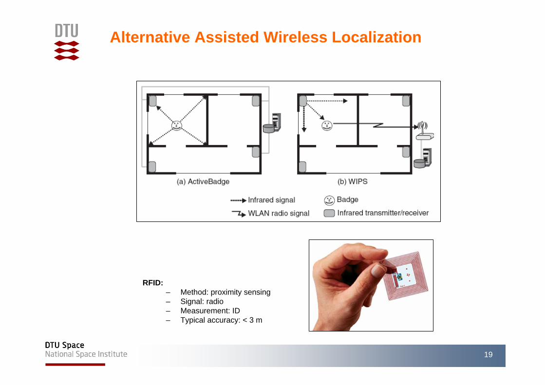
RFID:– Method: proximity sensing– Signal: radio– Measurement: ID– Typical accuracy: < 3 m
Alternative Assisted Wireless Localization

20
Bayesian Filtering:
– Bayesian filtering techniques are techniques that estimate the state of a dynamic system based on noisy sensors’ measurements.
– To the specific case of location information estimation in scenarios with static or moving devices, the Bayesian filtering techniques are being used in order to optimize accuracy.
Cooperative Wireless Indoor Localization
21
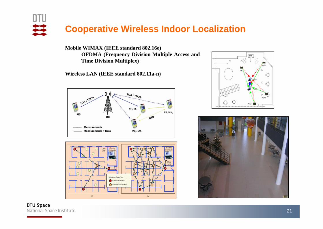
Mobile WIMAX (IEEE standard 802.16e)OFDMA (Frequency Division Multiple Access and Time Division Multiplex)
Wireless LAN (IEEE standard 802.11a-n)

22
MS1 and MS2 are connected to BS1, which is considered as the reference BS for TDOA measurements
BS1
BS2
BS3
BS4
MS1
MS2

23
SCENARIOMobility Model
ON / OFF
Mobile WiMAX802.16e
WLANAd-Hoc802.11a
EKFNo Coop
EKFCoop
Initial Positions MSs
BSs Coordinates
RSS
TDOA
PERFORMANCE COMPARISON

24
200 sets of 200 measurements ofTDOA and RSS (Received Signal Strength)

25
NO COOPERATION

Cooperative Wireless Indoor Positioning
26
16 m
30 m

27

28

29

Thank You !
30