influence of regional geology and hydrogeology on river
TRANSCRIPT

Atlantic Geology 185
Influence of regional geology and hydrogeology on river habitat quality: examples from Mill Brook and Elderkin Brook, Kings County, Nova Scotia
Ian S. Spooner1, Heather Fenton2 and M elody M yers3 1Department o f Geology and Environmental Science Program,Acadia University, Wolfville, Nova Scotia BOP IPO, Canada
departm ent o f Geology and Geophysics, University o f Calgary, Calgary, Alberta T2N1N4, Canada 3Geological Survey o f Canada, Terrain Sciences Division,
601 Booth Street, Ottawa, Ontario K1A 0E8, Canada
Date Received July 17, 1998 Date Accepted November 19, 1998
Elderkin Brook and M ill Brook are tributaries of the Cornwallis River and were investigated with the intent of understanding the geological conditions that could influence both habitat quality and river restoration efforts. The Cornwallis River and its tributaries have been the focus of restoration efforts in an attempt to re-establish brook trout (Salvelinus fontinalis) and Atlantic salmon (Salmo salar) populations. Both tributaries are relatively short, high- gradient headwater streams that are ungraded along much of their length.
Data from Elderkin Brook indicate that pyrite-rich slate of the Kentville and Halifax formations that dominate the watershed geology do not govern the pH of the river discharge. The carbonaceous New Canaan Formation buffers regional groundwater and has resulted in elevated pH levels (7.5-8.0). Springs in the ungraded portion of Elderkin Brook introduce slightly acidic iron-rich groundwater into the system and, upon contact with the alkaline discharge, have produced sporadic masses of flocculated ferric hydroxide (Fe(OH) 3). Along the upper reaches of Mill Brook, iron-rich acidic groundwater (pH 5.0-5.5) originating from the Kentville Formation influences the chemistry of the river discharge during low-flow conditions. However, groundwater input from the porous, calcareous-cemented Wolfville Formation that underlies the lower portion of Mill Brook has resulted in locally elevated pH levels (6.0-6.5) and the precipitation of extensive Fe(OH)3 deposits.
In both Elderkin Brook and Mill Brook, the precipitation, deposition and preservation of ferric hydroxide is controlled by regional and local, geological and hydrogeological conditions. During the winter and spring, increased discharge and dilution of the groundwater chemistry by precipitation keep iron in either solution or suspension. During low-flow periods (primarily in the fall) flocculated ferric hydroxide accumulations develop coincident with the spawning of both fish species. These conditions result in both temporally and spatially constrained habitat degradation that may be difficult to recognise using the habitat evaluation techniques that are presently being employed by river management groups.
Le ruisseau Elderkin et le ruisseau Mill sont des affluents de la riviere Cornwallis; on les a etudies dans le but de comprendre les conditions geologiques qui pourraient influer tant sur la qualite de l ’habitat que sur les efforts de remise en etat de la riviere. La riviere Cornwallis et ses affluents ont fait l’objet de travaux de remise en etat visant 4 retablir les populations d’ombles de fontaine (Salvelinus fontinalis) et de saumons atlantiques (Salmo salar). Les deux affluents sont des cours d’eau d’amont relativement peu etendus A forte declivite et au lit accidents sur une bonne partie de leur longueur.
Les donndes provenant du ruisseau Elderkin rdvelent que l’ardoise riche en pyrite des formations de Kentville et d’Halifax qui predomine dans la structure geologique du bassin versant ne regit pas le pH du debit fluviatile. La Formation carbonde de New Canaan tamponne l’eau souterraine de la region et elle a entraine des pH 61ev6s (7,5-8,0). Les sources qui coulent dans la partie accidentee du ruisseau Elderkin introduisent de l ’eau souterraine riche en fer l^gerement acide dans le reseau et elles ont, au contact avec l ’ecoulement alcalin, produit des masses sporadiques d’hydroxyde ferrique [Fe(OH)3] flocuie. Le long des sections supSrieures du ruisseau Mill, l ’eau souterraine acide riche en fer (pH de 5,0-5,5) en provenance de la Formation de Kentville influence la composition chimique du debit fluviatile a l’etiage. L’apport d ’eau souterraine de la Formation a ciment calcaire poreux de Wolfville sous-jacente & la partie inferieure du ruisseau Mill a entrain^ des pH localement Aleves (6,0-6,5) et la precipitation de vastes depots de Fe(OH)3
Dans les ruisseaux Elderkin et Mill, la precipitation, la sedimentation et la conservation de l ’hydroxyde ferrique sont fonctiondes conditions geologiques et hydrogeologiques regionales et locales. En hiver et auprintemps, l’ecoulement accru d’eau souterraine et la dilution de sa composition chimique due a la precipitation maintient du fer en place en solution ou en suspension. Pendant les periodes d’etiage (surtout l ’automne), l ’hydroxyde ferrique flocuie s’accumule au moment de la periode de frayage des deux especes de poissons. Ces conditions entralnent une degradation de l ’habitat qui est soumis a des contraintes temporelles et spatiales qu’il pourrait etre difficile de caracteriser au moyen des techniques devaluation de 1’habitat presentement employees par les groupes de gestion des rivieres.
Traduit par la redactionAtlantic Geology 34, 185-194 (1998)
0843-5 5 61 /98 /030185-10S2.50/0

186 Spooner et al.
I n t r o d u c t io n
In the past four decades, as the potential consequences of a decline in water quality and quantity became more widely known, much effort has focused on habitat quality within lotic systems. Research by Bancroft (1994), Brookes (1996), Brookes and Sear (1996), Brookes and Shields (1996) and Lanka et al. (1987) has centred on habitat-focussed restoration and the link between the channel and the floodplain. As the floodplain is the part of a river system that is typically most heavily used, it is commonly also the most degraded and, as such, few studies have examined the ungraded portions of streams. However, in Nova Scotia (and much of Appalachia) streams are commonly ungraded along much of their length. As ero- sional processes have not adjusted to rock resistance, rapids and waterfalls are common along these streams. Floodplain development is limited as they are relatively young (a consequence of glaciation) and have been subjected to post-glacial base-level fluctuations. These conditions result in an ungraded morphology in which the fluvial system is not in equilibrium and is not able to adjust to changes in its controlling factors (Easterbrook, 1999). In such systems, more subtle, mainly natural indicators of habitat degradation are commonly overlooked.
Most habitat-focussed restoration efforts do not consider the restored reach as part of a larger river-riparian system within an even larger catchment (Gore, 1985). Even less well understood are regional influences that transcend the catchment scale (Fenton etal., 1998). This study shows that regional geology and hydrogeology can influence habitat quality in ways that m ight not be anticipated using evaluation techniques commonly employed by river management groups. We also demonstrate that the collection of spatially and temporally restricted water chemistry and geological data can lead to an erroneous evaluation of the habitat quality within a lotic system.
R e g io n a l s e t t in g
The Annapolis Valley lies between two uplands, North M ountain and South Mountain. The former is a north-dipping basalt-capped ridge that peaks at 238 m; the latter is underlain mainly by a granitic pluton and has a maximum elevation of 282 m. A suite of folded and north-dipping meta- morphic and clastic sedimentary rocks is located north of South Mountain. The Cornwallis River is restricted to the floor of the Annapolis Valley and drains into the Minas Basin. MfllBrook(45°04’N,64°30’W)andElderkinBrook(45003,N, 64°29’W) are both high-gradient tributaries that originate on South M ountain (Fenton, 1998; Myers, 1998). Mill Brook is fed by tributaries that drain the southern upland areas; it has a watershed of 45 km2and is 10 km long. Mill Brook is geomor- phologically young and non-graded along much of its length, with an average gradient of 21 m/km. Downstream it is graded with an average gradient of 15 m/km. This gradient change is due, in part, to a change in bedrock from resistant slate of the Kentville Formation to less resistant sandstone of the Wolfville Formation (Myers, 1998; Fig. l).E lderkin Brook has a water
shed of 10 km2; the upper 3.0 km2 of the watershed was the focus of this study and includes first and second order tributaries that together measure approximately 2.5 km in length (Fenton, 1998). The studied section of the brook is non-graded with a gradient of 40 m/km for first-order tributaries and 25 m/ km for second-order tributaries.
The Annapolis Valley receives about 100 cm of precipitation annually (Holmstrom and Thompson, 1989). The geomorphology of the region is similar to that of much of northern Appalachia and is characterised by glaciated landscapes, moderate relief and variable thickness of overburden.
G e o l o g y
The southern side of the Annapolis Valley is dominated by metamorphosed sedimentary and volcanic rocks. The Early Ordovician Halifax Formation consists of laminated black slate that outcrops at both the Mill Brook and Elderkin Brook sites (Fig. 1). It is locally pyritiferous, well-laminated, cleaved and, in places, phyllitic (Smitheringale, 1973). The Early Silurian White Rock Formation also outcrops at both sites and consists of massive to weakly laminated quartzite, slate, conglomerate and greywacke (Raeside and Jamieson, 1992). The main impurities within the sedimentary members are sericite, chlorite and hematite. The Silurian Kentville Formation occurs at both sites and consists of slate and minor siltstone. It has prominent bedding, is very strongly cleaved and, locally, has a high graphite content. The main impurities are hematite, biotite and secondary limonite; m inor magnetite and pyrite occur locally (Smitheringale, 1973). The New CanaanForma- tion outcrops in the Elderkin Brook watershed and consists of interstratified basaltic tuffs and flows, fossiliferous limestone and limy siltstone, all metamorphosed to biotite grade (James, 1998). Calcite-filled veinlets are common and the slatey beds locally contain high concentrations of sulfide minerals. The Triassic Wolfville Formation outcrops in the lower reaches of both tributaries and consists of poorly sorted red and brown arkosic sandstone, siltstone, conglomerate and shale; detri- tal hematite is common within the formation. The formation can be porous and contains calcite cement; it is considered to be one of the best groundwater aquifers inNova Scotia (Trescott, 1968; Henniger etal., 1992). The Devonian South Mountain Batholith is located south of both study areas and consists of massive monzogranite and granodiorite.
The type and distribution of surficial sediments in the study area is a reflection o f the glacial processes that dominated the area during the late Wisconsinan. Both regional and local ice sheets were active and resulted in a complex ice flow history; at some locations multiple till sheets were deposited (Stea and Mott, 1989). The last regional ice advance in western Nova Scotia moved toward the south from the northwest and resulted in the deposition of a silty reddish- brown till locally known as the Lawrencetown till (Stea et al., 1992). This till has low permeability and high iron content; it generally is less than 3 m thick within the study area. Karnes are common in the region, particularly on the valley sides and consist of small, moderately sorted sand and gravel deposits that are mined for aggregate.

A tlantic Geology 187
Fig. 1. Location map and general geology of sites discussed in this paper. Both M ill Brook and Elderkin Brook are tributaries of the Cornwallis River. They are high gradient, headwater streams that are ungraded along much of their length. Bedrock outcrop is common along much of the upper portions of both tributaries.
R e g io n a l h y d r o g e o l o g y
The study area is underlain by both nonporous but highly fractured metamorphic rocks and porous unmetamorphosed sedimentary rocks. These are overlain by a veneer of till and,
locally, sand and gravel of varying thickness. The most significant aquifers in the study region occur within porous sandstone and conglomerate of the Wolfville Formation. Porosity can reach 16% where the calcite cement has been dissolved (Trescott, 1968). The calcite cement within the Wolfville Formation buff
188 Spooner et al.
ers groundwater pH, and well water taken from this formation has a pH of 6.7 (Trescott, 1968; Levy, 1998).
The metamorphic rocks in general have low primary porosity (<5%; Trescott, 1968). Cleavage plane separations can be major hydraulic conduits and, in combination with fractures, cause elevated conductivities with high anisotropy (Trescott, 1968). The New Canaan Formation has the greatest storage potential due to its synclinal structure, high fracture density and the relative impermeability of the underlying formations (James, 1998; Trescott, 1968). However groundwater storage is limited and can be sustained only if recharge is continuously available (Randall etal., 1988). Conductivities within porous fractured bedrock average about 16.5 x 10“* cm/ s and are somewhat reduced in porous unfractured bedrock units (3.2 x 10⁻⁴ cm/s; Randall etal., 1988). The southern uplands (South Mountain) probably contribute appreciable water at low-flow periods as the extensive bogs and lakes yield water slowly to streams and sustain baseflow for extended periods. During prolonged dry weather, these sources diminish and stratified drift is probably an important source for replenishing stream discharge.
Overburden composition also influences water availability from bedrock. Yields are generally lower where till, as opposed to stratified drift, overlies bedrock, a condition that characterises both study areas (Randall et al., 1988). The Lawrencetown Till is the dominant overburden cover and in general has a low conductivity (Fenton, 1998). In upland areas the till is generally coarser grained and less highly consolidated which tends to increase its storage potential, however, this is offset by its diminished thickness. Karnes are found at both study sites but generally make up less than 3% of the surface cover. These deposits have high conductivities (Kempt, 1997) and are most common in the lower portions of both watersheds. They, therefore, have a limited capacity to replenish discharge in the upper reaches.
Both ground water and river discharge, in general, meet provincial drinking water standards for common ions; however, iron contamination is commonly reported (Kempt, 1997). Precipitation is acidic (pH 4.5-5.5; Fenton, 1998) and both the surficial sediment and the bedrock have little buffering capacity (Trescott, 1968).
B a c k g r o u n d : t a r g e t s pe c ie s f o r r e st o r a tio n
Most river habitat quality assessments in western Nova Scotia are centred on restoring populations of either Atlantic salmon (Salmo salar) or brook trout (Salvelinus fontinalis). The former was once an important commercial species in the region and both are sought after by sports fishermen. Populations of these species are known in both the Cornwallis River and the two tributaries discussed in this study. River managers in Nova Scotia often use the habitat and water quality tolerances of these two species to establish guidelines for restoration projects (B. Lenentine, personal communication, 1998).
Atlantic salmon are anadromous; they hatch in freshwater streams, migrate to salt water and return to freshwater to reproduce. Spawning in the Cornwallis River watershed is most common from the late summer to fall, however it does
occur at the same time each year for a particular river (Nova Scotia Department of Fisheries, 1998). Salmon generally migrate upriver during high flow periods, require clean well aerated gravel in which to build a nest (or redd) and water flow must be maintained over the 110 days required for the eggs to develop. Upon hatching, the young fish (alevins) remain buried in the gravel for up to five weeks. For the first year the young salmon (now called parr) remain within the stream, usually in a shallow riffle feeding on insects and invertebrates. At two years of age, the parr migrate to salt water where they remain for up to eight years.
Brook trout have less complicated life cycles. In October and November they spawn in the shallow gravel beds of streams where there is sufficient water flow; spring-fed headwaters are ideal but the gravel bed of lakes is also suitable. The female builds a nest in the gravel and buries the eggs; the nest must be kept silt free for the eggs to develop. The eggs hatch in the spring and the alevins remain in the gravel until the yolk sack is absorbed. Brook trout eat aquatic insects and prefer clean, cool water and a gravel substrate as habitat. Some populations migrate to the sea for short periods of time (two months) but typically remain within the estuary. This migration is thought to be in response to either crowded conditions, low food supplies or unfavourable temperatures (Nova Scotia Department of Fisheries, 1998).
P r e v io u s w o r k
Studies on the impact of regional geology on restoration efforts are, in general, limited. Hey (1994) demonstrated that the design of restoration projects should focus on the relationships between geology and river ecology. Sear (1994) argued that watershed geomorphology should be the primary component in the design of restoration projects. He concluded th a t m ore a tten tio n should be paid to large-scale geomorphological and geological features as opposed to the scaling and siting of in-stream structures. These studies suggest that a complete geological assessment at the design stage of a restoration project will help ensure that sustainable remediation takes place.
Work done by Allen (1998), Fenton (1998), Levy (1998), Myers (1998) and Nelson (1998) has focussed on the hydrodynamics and geochemistry of the Cornwallis River watershed. Data from these studies has quantified how these systems react to a variety of input and discharge conditions. These studies were undertaken, in part, to provide river management groups with a more comprehensive database with which to evaluate habitat quality and restoration potential.
M e t h o d o l o g y
Data primarily was collected from the high-gradient, ungraded portions of both M ill Brook and Elderkin Brook. Data for Mill Brook was collected daily from May 1995 to September 1997 and data for Elderkin Brook was collected daily from July 1997 to October 1998. These studies were done over an extended period of time during a variety of hydrological conditions as the mechanism of water supply to the river can

A tlantic Geology 189
profoundly affect the water chemistry within the river. It is important to understand the range of conditions in both brooks as it is not the average but often the extreme conditions that determine the habitat quality of a given system.
The instrumentation used to collect data in this study was similar to that commonly used by river management teams during initial habitat quality and restoration assessment. As such, our ability to evaluate the restoration potential of both tributaries was not a function of the sophistication or exclusivity of our instrumentation. We intend to demonstrate that an accurate assessment of the geological influences on habitat quality is possible using basic water-quality evaluation techniques.
Geomorphic data were collected from both aerial photographs and orthophoto maps, and included river length, watershed area and slope, and gradient (Fig. 2). Data collected during stream surveys included depth, flow velocity, discharge, alluvial substrate composition, pool-riffle-run distribution, thalweg development, and identification of bedrock and overburden outcrop along the length of both tributaries. Clast- size distribution was obtained both by sieving and, for boulder-sized clasts, by visual inspection. Data collected for Mill Brook also included discharge density and viscosity, used to quantify the mechanics of sediment movement. These data were required to compute the Reynold’s number that gives an indication of whether flow is turbulent, laminar or transitional. Basic geometric data (width, depth, cross-sectional profile) were also collected for both brooks. Water and air temperature was recorded in pools in both brooks using Hobo Temp™ temperature data loggers. Field saturated hydraulic conductivity was measured using a Guelph Permeameter.
Basic water chemistry data was collected using a YSI™ water quality meter that measures pH, conductivity, temperature and dissolved oxygen content. Select water and soil samples were also sent to Nova Scotia Agricultural College for ICP- MS analysis of common ions. Field test kits were used on occasion to determine the chemical characterisitcs of sediment accumulations within the rivers.
R esults
General
The watersheds for M ill Brook and Elderkin Brook have similar morphologies. The catchment gradients for both sites increases toward the channel and can be as high as 500 m/km. Both brooks are incised along much of their length (Fig. 3) and bedrock is common in both the channel and along the channel sides. The Elderkin Brook watershed is located on a northeast-trending syncline composed of highly fractured, non-porous metamorphosed sedimentary rocks. Glacial deposits form a veneer over bedrock and range from less than 1 m to 8 m thick. Approximately 90% of the overburden is silty, compact, clay-rich Lawrencetown Till. It has very low permeability and transports water through fractures and sandy lenses. The rest of the overburden is composed of highly permeable sand and gravel kame deposits. Topsoil is generally a sandy, friable loam and is less than 1 m in thickness. Anthropogenic
Distance from source (kilometres)
Fig. 2. Gradients and reach designations for Mill Brook and Elderkin Brook. Reaches 1,2 and 3 are ungraded and are the focus of this paper.
impact on both watersheds is light with land use being restricted to low density rural-residential dwellings and scattered farms (Fig. 3).
Stream morphology and sedimentology
Mill Brook and Elderkin Brook have been subdivided into four reaches (R1-R4, Fig. 2) on the basis of morphology and gradient. Reaches 1,2 and 3 are ungraded and are the primary focus of this study. Reach 4 is graded for both brooks. The uppermost reach for both sites (R l) has a low gradient (Table 1, Fig. 2), and discharge is ephemeral. The substrate in the channel bottom is highly variable but in general is poorly sorted gravel. Both the thalweg and bars are absent from these reaches and pool development is poor. When discharge was present (during input events and spring runoff) flow was turbulent. The catchments are poorly drained and relief is subdued. Bedrock outcrops sporadically but is most often less than 2 m from the surface. Habitat quality within R l for both Mill Brook and Elderkin Brook is poor due to the ephemeral discharge.
Reach 2 of both brooks is highly incised and has a steep gradient (Table 1, Fig. 2); sinuosity is low. Bedrock outcrop is common both within and along the sides of the channel and, although both bar deposits and a well-developed thalweg are rare, riffles and pools are common. The freestone substrate in both M ill Brook and Elderkin Brook is mostly gravel. Discharge is perennial. Flow is generally turbulent but transitional Reynold’s numbers can occur, especially in pools during low discharge periods.
A bright yellow precipitate that also contains silt to fine sand to clay-sized sediment was observed at specific locations within R2 in Elderkin Brook. The precipitate has poorly developed crystal structure, contains >100 ppm of total iron and was designated ferric hydroxide (Fe(OH)3). Deposits were observed mostly during periods of low discharge. Where (and when) present this sediment both coats and embeds the surrounding gravel clasts reducing in-stream turbulence at the bed. However, discharge within R2 is generally turbulent.
Reach 3 (R3, Fig. 1) of both brooks has a poorly to moderately developed floodplain that is in places terraced. This

190 Spooner et al.
Fig. 3. Aerial photograph of Elderkin Brook. Note that the stream is highly incised along much of reach 2. The watershed is dominated by mixed wood and hardwood forest; anthropogenic impact is minimal. Arrows point to location of brook, reach designations are indicated (R1, R2).
reach is not highly incised and has a moderate to low gradient (Table 1, Fig. 2). Bedrock outcrop is less common than in the upper reaches, both within and along the sides of the channel. Bar deposits are common and both brooks contain a well- developed thalweg and pool/riffle/run structure along these reaches. The freestone substrate is finer-grained than R2 (medium to fine gravel). Flow is perennial but discharge can be very low, especially during drought conditions. This may be a function of the increased transmissitivity and storativity of the thicker accumulations of alluvial sediment. Flow is generally turbulent (Re >20,000) but Reynold’s numbers can be low (Re <5000) during extreme low-flow conditions.
A significant portion of R3 for Mill Brook contains a combination of ferric hydroxide and fine sand to clay-sized clastic sediment. The sediment was most common during low-discharge periods. In pools it both coats and embeds the gravel clasts and is present in the interclast voids of gravel in riffles. It occurs downstream where Wolfville Formation sandstone outcrops along the side of the brook. Isolated sections of R3 for Elderkin Brook also contain this sediment.
Discharge geochemistry and regional hydrogeology
Water quality is adequate for the target species within R2 and R3 in both M ill Brook and Elderkin Brook. Though no direct guidelines exist for fish, the concentrations of common ions did not exceed provincial drinking water standards and are considered acceptable for the target species. Elderkin Brook
is well buffered in all reaches with a range in pH of between 6.97 and 8.08. In M ill Brook discharge in reaches R1 andR2 had much lower pH values (ca. 5.5) than recorded in R3 and R4 (ca. 7.1). The increase in pH occured as bedrock lithology changes from the pyritiferous slate of the Halifax Formation to sandstone of the Wolfville Formation. This trend in pH was absent when the river was in flood.
In both brooks, dissolved oxygen levels in R1 and R2 were generally high (ca. 13.2 mg/1), even during low-flow conditions, but were somewhat lower (11.54 mg/1) inR3 of Mill Brook. Both brooks showed relatively low thermal inertia in riffles as water temperature tended to mimic air temperature, especially at times of low flow. The maximum daily temperature range recorded in Mill Brook was 6°C and was recorded in exposed riffles during drought conditions. Total dissolved solids values for both brooks averaged 230 mg/L. The discharge in both brooks is relatively high in iron (Fe2+) with values ranging from 0.14 mg/L to 0.31 mg/L. Geochemical analysis of the regional till showed relatively high levels of Fe20 3 (4.90%) and low levels of CaO (0.84%).
Both the Mill Brook and Elderkin Brook watersheds probably react in similar ways to precipitation events. Discharge peaks are coincident with input events and hydrographs show both a steep rising and falling limb and a narrow crest in response to an input event. Both watersheds have restricted surface storage potential. The hydraulic conductivity of the till is low and averaged 0.25 x 10'4 cm/s; for stratified deposits it averaged 5.0 x 10'2 cm/s. Discharge within R1 is ephemeral and

A tlantic Geology 191
Table 1. Select geomorphic and geochemical data for Mill Brook and Elderkin Brook.
Mill Brook Elderkin Brook
Area of watershed under study (km2) 45 3Length of tributary under study (km) 15 7Tributary order 2,3 1,2Gradient (m/km) Reach 1 7 7
Reach 2 19 29Reach 3 10 7Reach 4 4 5
Stream substrate freestone, bedrock freestone, bedrockBedrock in watershed slate, cong, shale, s.s. slate, cong, shale, s.s.Overburden till, kame till, kamepH of inputer: mean (range) 4.63 (4.21-5.29) 4.63 (4.21-5.29)pH of stream: mean (range) Reach 1 5.4 (5.11-6.03) 7.7 (6.97-7.98)
Reach 2 5.5(5.16-6.13) 7.6 (6.91-8.08)Reach 3 6.9(5.51-7.40) 7.9 (7.72-8.01)Reach 4 7.2 (6.67-7.80) 7.9 (7.88-8.01)
dominated by overland flow. Overland and return flow dominate discharge input in R2 and R3. The lower gradient and increased surficial cover in R4 leads to an increase in baseflow contribution. Springs are common in R1 andR2 in both streams and were identified by depressed water temperatures and independence from air temperature fluctuations.
I n t e r pr e t a t io n and d isc u ssio n
The morphological and general water chemistry data for reaches 2 and 3 in both M ill Brook and Elderkin Brook indicate that adequate conditions exist for both target species. At both sites habitat quality degradation primarily is associated with the precipitation and preservation of flocculated ferric hydroxide and associated fine-grained clastic sediments. Regional groundwater flow provides both the iron in solution and the necessary pH and oxidation-reduction state required to precipitate the ferric hydroxide. Seasonal variations in discharge dynamics are largely responsible for its preservation.
Most of the baseflow contribution for both brooks originates from bedrock and can be characterised as either fracture and pore controlled (Wolfville Formation) or fracture and joint controlled (New Canaan Formation) lateral and deep circulation through bedrock. Both till and stratified sediment are unimportant aquifers. Regionally, the till is th in and has low hydraulic conductivity; these characteristics, when combined with high catchment gradients, provide little opportunity for input infiltration. The limited distribution of the stratified sediment diminishes its importance as an aquifer.
In M ill Brook, an increase in pH is coincident with the transition within the watershed from bedrock of the Halifax Formation to Wolfville Formation bedrock and is an indication of the high conductivity and strong buffering capacity of baseflow originating from the Wolfville Formation. The
strong regional influence o f New Canaan Formation-sourced baseflow is indicated by the consistently high pH of Elderkin Brook discharge, a result of the contribution of groundwater from the highly conductive calcite filled fractures.
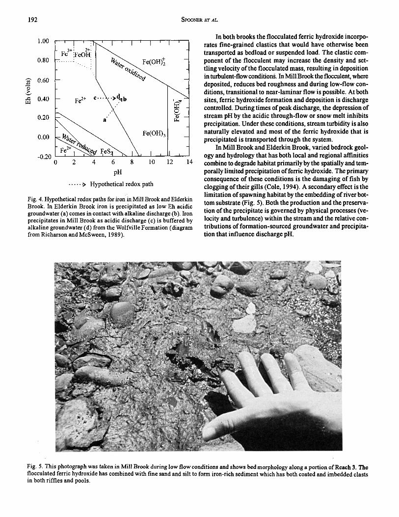
The precipitation of ferric hydroxide in both brooks is a consequence of both the availability o f iron in solution and an increase in discharge pH. In M ill Brook, iron in solution (Fe2*) is derived primarily from the mobilisation and redistribution of pyrite (FeS2) that is abundant in slate of the Halifax Formation. Much of the iron probably is transported in a reduced state by regional groundwater flow and the low pH in R1 and R2 keeps the iron in solution. The pyritiferous slate also outcrops along much of R2 and R3. Chemical weathering of outcrop is accelerated by acid precipitation and results in the oxidative decomposition of pyrite. This process both liberates iron and produces sulphuric acid which, in turn, lowers pH in those reaches underlain by slate and brings about further weathering. Alkaline groundwater from the Wolfville Formation buffers discharge pH in R3 and induces the precipitation of ferric hydroxide (as a flocculent) that becomes part of the suspended sediment load o f the brook (Fig. 4). Mill Brook is in an oxidative state. The decline in dissolved oxygen observed in R3 may be a consequence of both reduced turbulence and consumption of oxygen as iron is precipitated. Finegrained sediments being transported either in suspension or as bedload may become incorporated in the iron flocculent.
In the Elderkin Brook watershed iron in solution (Fe1*) is derived from the till and a variety of iron-rich minerals within the metamorphic rocks. Discharge is in general alkaline. The ferric hydroxide appears in isolated pockets often associated with bedrock within or at the sides of the channel. An increase in both the Eh (reducing groundwater to oxidizing discharge) and pH (acid groundwater to alkaline discharge) where springs contribute to discharge is responsible for localized precipitation (Fig. 4).
Eh
(vol
ts)
192 Spooner kt al.
........•> Hypothetical redox path
Fig. 4. Hypothetical redox paths for iron in Mill Brook and Elderkin Brook. In Elderkin Brook iron is precipitated as low Eh acidic groundwater (a) comes in contact with alkaline discharge (b). Iron precipitates in Mill Brook as acidic discharge (c) is buffered by alkaline groundwater (d) from the Wolfville Formation (diagram from Richarson and McSween, 1989).
In both brooks the flocculated ferric hydroxide incorporates fine-grained elastics that would have otherwise been transported as bedload or suspended load. The clastic component of the flocculent may increase the density and settling velocity of the flocculated mass, resulting in deposition in tuibulent-flow conditions. In Mill Brook the flocculent, where deposited, reduces bed roughness and during low-flow conditions, transitional to near-laminar flow is possible. At both sites, ferric hydroxide formation and deposition is discharge controlled. During times of peak discharge, the depression of stream pH by the acidic through-flow or snow melt inhibits precipitation. Under these conditions, stream turbidity is also naturally elevated and most of the ferric hydroxide that is precipitated is transported through the system.
In M ill Brook and Elderkin Brook, varied bedrock geology and hydrology that has both local and regional affinities combine to degrade habitat primarily by the spatially and temporally limited precipitation of ferric hydroxide. The primary consequence of these conditions is the damaging of fish by clogging of their gills (Cole, 1994). A secondary effect is the limitation of spawning habitat by the embedding of river bottom substrate (Fig. 5). Both the production and the preservation of the precipitate is governed by physical processes (velocity and turbulence) within the stream and the relative contributions of formation-sourced groundwater and precipitation that influence discharge pH.
Fig. 5. This photograph was taken in Mill Brook during low flow conditions and shows bed morphology along a portion of Reach 3. The flocculated ferric hydroxide has combined with fine sand and silt to form iron-rich sediment which has both coated and imbedded clasts in both riffles and pools.
A tlantic Geology 193
The formation and preservation of iron precipitate is a natural condition prim arily controlled by variations in groundwater chemistry and stream hydrodynamics, variables that are difficult to predict. Conditions for preservation (low flow, baseflow dominated discharge) unfortunately are coincident with the spawning period (late summer to fall) for both target species. The results of this study show that an effective assessment of river habitat quality must include an understanding of both the hydrodynamics of the river and the regional geology and hydrogeology of the watershed. Initial restoration assessments of M ill Brook and Elderkin Brook were carried out in the spring and early summer. As such, both the pH variability and the flocculent were not recognized. Data collection cannot be limited to a single, shortterm survey, a common practice in many assessments. In Mill Brook, the habitat within most of R2 is naturally degraded, in Elderkin Brook habitat is degraded in both R2 and R3, but to a limited extent. Restoration of habitat quality is impractical as the conditions required to keep iron in solution (increased discharge and more acidic discharge pH) would be difficult and expensive to implement.
C o n c l u s io n s
This study illustrates the necessity of understanding the geology of the catchment region, the geomorphology of the river system and the chemistry of both the ground and river water in order to properly plan and manage a river restoration effort. In both tributaries, an understanding of these parameters is fundamental to the correct interpretation of both the source of the iron in the w ater and the chem ical and geomorphological conditions that lead to the precipitation, deposition and preservation of the iron flocculent.
This study has also shown that the natural chemistry of both groundwater and river discharge can have a deleterious impact on the specific target species. The interaction of a dynamic river system with changing chemical and geological conditions can lead to the development of habitat degradation that might not be apparent if standard habitat quality assessment techniques are applied.
A c k n o w l e d g e m e n t s
This research was funded by NSERC (I. Spooner) and Acadia University. The authors would like to thankB. Lenentine and the Friends of the Cornwallis River Association (FOCS) for their assistance and logistical support. A. Levy (Department of Biology, Acadia University) andR . Bannister (Nova Scotia Department of Fisheries) provided helpful comments while in the field. A. Macdonald (Acadia University) provided insight on the water chemistry analyses. Comments by P. Giles and D. Liverman greatly improved the manuscript.
A llen, M. 1998. Abiological oxygen demand and associated water quality aspects profile o f the Cornwallis River, Kings County, N.S. Unpublished Honours thesis, Acadia University, Wolfville, Nova Scotia, 50 p.
B ancroft, R. 1994. Water quality management for decision maker: A historical overview. In Proceedings, Seminar/Workshop on
Water Quality Management for Decision Makers. November 29-30,1994. Technical University of Nova Scotia, Continuing Education Division, Halifax, Nova Scotia.
B rookes, A. 1996. River restoration experience in northern Europe. In River Channel Restoration: Guiding Principles for sustainable projects. Edited by A . Brookes andF.D. Shields Jr. John Wiley and Sons, Toronto, pp. 233-268.
B rookes, A. and Sear, D.A. 1996. Geomorphic principles for restoring channels. In River Channel Restoration: Guiding Principles for sustainable projects. Edited by A. Brookes and F.D. Shields Jr. John Wiley and Sons, Toronto, pp. 75-102.
B rookes, A. and Shields, F.D., Jr . 1996. Perspectives on river channel restoration. In River Channel Restoration: Guiding Principles for sustainable projects. Edited by A. Brookes and F.D. Shields Jr. John Wiley and Sons, Toronto, pp. 1-20.
C ole, G.A. 1994. Textbook of Limnology. Waveland Press, Illinois, 412 p.
Easterbrook, D.J. 1999. Surface Processes and Landforms. Prentice Hall, Upper Saddle River, New Jersey, 546 p.
F enton, H. 1998. A model of storage potential and input transferal patterns of the Elderkin Brook watershed, Kings County, Nova Scotia. Unpublished Honours thesis, Acadia University, Wolfville, Nova Scotia, 53 p.
Fenton, H., Levy, A., and Spooner, 1 .1998. Hydrogeological analysis of the watersheds of two tributaries of the Cornwallis River, Nova Scotia: implications for stream restoration and enhancement. Atlantic Geoscience Society Colloquim and Annual General Meeting, February 6-7,1998, Program and Abstracts, p. 13.
G ore, J.A. 1985. The Restoration of Rivers and Streams: Theories and Experience. Butterworth Publishers, Toronto, 280 P-
H enniger, T.W., G ibb, J., C ruickshanks, F., and R othfischer, J. 1992. Hydrogeological and groundwater interests in the An- napolis-Comwallis Valley. Geological Association of Canada, Mineralogical Association of Canada, Joint Annual meeting, Wolfville 1992, Field Trip C-4, Guidebook, 15 p.
H ey, R.D. 1994. Restoration of gravel-bed rivers: principles and practices. In Natural Channel Design: Perspectives and Practices. Edited by D. Shrubsole (publisher). Niagara Falls, Ontario, pp. 157-168.
H olmstrom, D.A. and T hompson, B.L. 1989. Soils of the Annapolis Valley Area of Nova Scotia. Report No. 22, Nova Scotia Soil Survey. Land Resource Research Centre Contribution 89-8, Agricultural Development Branch, Agriculture Canada, 184 p.
James, J. 1998. Stratigraphy, petrochemistry and economic potential of the Silurian New Canaan Formation, Meguma Ter- rane, Nova Scotia. Unpublished Honours thesis, Acadia University, Wolfville, Nova Scotia, 111 p.
K empt, M.R. 1997. An evaluation of the geochemistry of ground and surface waters in Kingston, NS and its interaction with the surficial geology and landuse practices in the surrounding watershed. Unpublished Honours thesis, Acadia University, Wolfville, Nova Scotia, 78 p.
Lanka, R.P., H ubert, W.A., and W esche, T.A. 1987. Relations of geomorphology to stream habitat and trout standing stock in small Rocky Mountain streams. Transactions of the America Fisheries Society, 116, pp. 21-28.
Levy, A. 1998. A short-term watershed analysis of Fishwick Brook inBerwick, Nova Scotia, during a drought. Unpublished Honours thesis, Acadia University, Wolfville, Nova Scotia, 67 p.
M yers, M. 1998. A detailed investigation of the morphological impact of in-stream remediation structures on Mill Brook, Kings County, Nova Scotia. Unpublished Honours thesis, Acadia University, Wolfville, Nova Scotia, 69 p.

194 Spooner bt al.
N elson, A. 1998. A survey of fecal coliform levels and related water quality parameters in the Cornwallis River, Kings County, Nova Scotia. Unpublished Honours thesis, Acadia University, Wolfville, Nova Scotia, 45 p.
N ova Scotia D epartment of F isheries. 1998. Nova Scotia Fish Series. Nova Scotia Department of Fisheries, P.O. Box 700, Pictou, Nova Scotia, BOK 1H0.
R aeside, R.P. and Jamieson, R.A. 1992. Low-pressure metamorphism of the Meguma Terrane, Nova Scotia. Geological Association of Canada, Mineralogical Association of Canada, Joint Annual Meeting, Wolfville 1992, Field Excursion C-5, Guidebook, 25 p.
Randall, A.D., F rancis, R.M., F rimpter, M.H., and E mery, J.M. 1988. Region 19, Northern Appalachians. In Hydrogeology: Boulder, Colorado. Edited by W. Back, J.S. Rosenshein and P.R. Seaber. Geological Society of America, The Geology of North America, Vol. 0-2, pp. 177-187.
R ichardson, S.M . andMcSwEEN, H.Y., Jr . 1989. Geochemistry: Pathways and Processes. Prentice Hall, New Jersey, 488 p.
Sear, D.A. 1994. River restoration and geomorphology. Aquatic Conservation: Marine and Freshwater Ecosystems, 4, pp. 169-177.
Smitheringale, W.G. 1973. Geology of parts ofDigby, Bridgetown, and Gaspereau Lake map-areas, Nova Scotia. Geological Survey of Canada, Memoir 375, 78 p.
Stea, R.R. and M ott, R.J. 1989. Deglaciation environments and evidence for glaciers of Younger Dryas age in Nova Scotia, Canada. Boreas, 18, pp. 169-187.
Stea, R.R., F orbes, D.L., and M ott, R.J. 1992. Quaternary geology and coastal evolution of Nova Scotia. Geological Association of Canada, Mineralogical Association of Canada, Joint Annual Meeting, Wolfville 1992,FieldExcursion A-6, Guidebook, 125 p.
Trescott, P.C. 1968. Groundwater resources and hydrogeology of the Annapolis-Comwallis Valley, N.S. Nova Scotia Department of Mines, Memoir 6, 159 p.
Editorial Responsibility: S.M. Barr