inishargy house, kircubbin county down...inishargy house, kircubbin county down excavation and...
TRANSCRIPT

Inishargy House, Kircubbin County Down
Excavation and monitoring carried out
on behalf of NIEA
By
The Centre for Archaeological Fieldwork,
School of Geography, Archaeology and Palaeoeclogy,
Queen’s University Belfast,
BT7 1NN
Sapphire Mussen
CAF DSR No. 94
Excavation Licence No: AE/12/149
Planning Reference: X/2012/0053/F
SMR No: DOW 018:020
Grid Reference: J 6047 6468
25th July 2013

Centre for Archaeological Fieldwork, QUB Inishargy House, Co. Down AE/12/149 CAF DSR No.94
1
Contents
List of Figures ....................................................................................................................................... 2
List of Plates .......................................................................................................................................... 3
1 Summary ....................................................................................................................................... 5
2 Introduction ................................................................................................................................. 6
3 Site Location and description ..................................................................................................... 6
4 Cartographic evidence ............................................................................................................... 7
5 Summary Phasing of Inishargy House ...................................................................................... 9
6 Account of the excavation and monitoring ............................................................................ 11
7 Conclusions and Recommendations ...................................................................................... 15
8 Acknowledgements .................................................................................................................. 16
References ........................................................................................................................................... 16
Archive ................................................................................................................................................. 16
Figures ................................................................................................................................................. 17
Plates .................................................................................................................................................... 24

Inishargy House, Co. Down AE/12/149
2
List of Figures
Figure 1 Map showing the location of Inishargy
Figure 2 Extracts from 6-inch Ordnance Survey maps of Inishargy
Figure 3 Ground plan of Inishargy House (Robinson & Oram 1983)
Figure 4 Illustration of Inishargy House before modernisation (Robinson & Oram 1983)
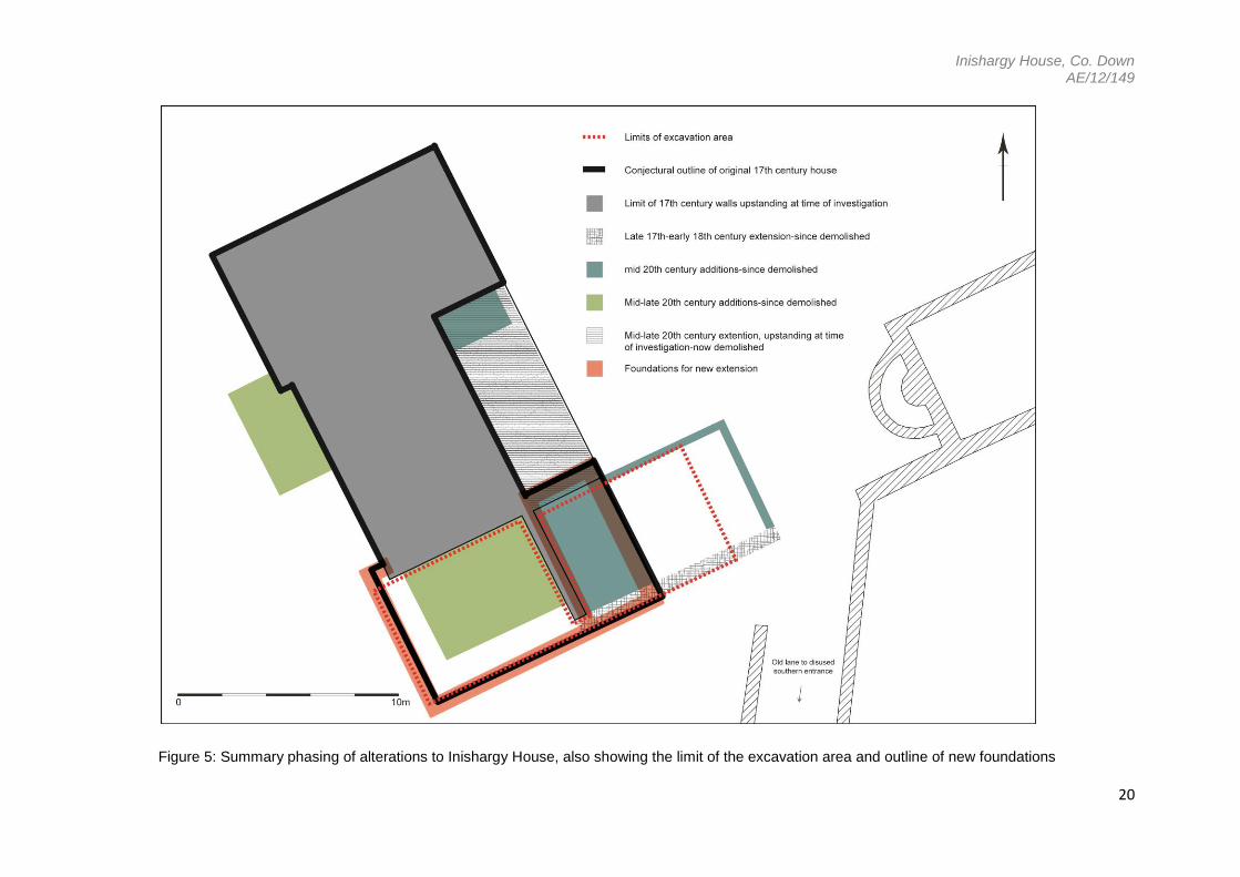
Figure 5 Summary phasing of alterations to Inishargy House
Figure 6 Area 1, with additions as uncovered during monitoring of foundation trenches
Figure 7 Area 2, east of the 17th-century cross-wall
Figure 8 Plan of foundations for new extension overlying previous structural remains

Inishargy House, Co. Down AE/12/149
3
List of Plates
Plate 1 East-facing view of Inishargy House as it stood when purchased by current owners in
the early 20th century (landowner’s personal collection)
Plate 2 Aerial view of Inishargy House, yard and out-buildings, looking northeast, dated 1966
(landowner’s personal collection)
Plate 3 Southwest-facing view of Inishargy House in the mid 20th century (landowner’s
personal collection)
Plate 4 Northeast-facing view of Inishargy House in the late 20th century (landowner’s
personal collection)
Plate 5 Southeast-facing view of semicircular ‘tower’
Plate 6 Stairs and ‘gun-loop’ in the semicircular ‘tower’
Plate 7 Stone mouldings and reused cut stone in the vicinity of Inishargy House
Plate 8 Stone mouldings found lying in the vicinity of Inishargy House
Plate 9 Northeast-facing view of wall containing blocked-up ovens and a fireplace
Plate 10 Northeast-facing view of blocked-up oven in 17th-century cross-wall
Plate 11 Northwest-facing view of the top of the southern end of the 17th-century cross-wall
Plate 12 Northwest-facing view of the base of the southern end of the 17th-century cross-wall
Plate 13 Northwest-facing view of a corner of Inishargy House post removal of the cross-wall
Plate 14 Northwest-facing view of a corner of Inishargy House post removal of the cross-wall
Plate 15 Southwest-facing view of Inishargy House post removal of extensions
Plate 16 Northwest-facing view of Inishargy House post removal of extensions
Plate 17 Northeast-facing view of cross-wall and brick walls uncovered during evaluation
Plate 18 Northeast-facing view of walls uncovered during evaluation
Plate 19 Southwest-facing view of walls uncovered during evaluation
Plate 20 Southwest-facing view of site mid-clearance of rubble and concrete flooring
Plate 21 View from above and looking southwest of brick floor and cobbled surfacing

Inishargy House, Co. Down AE/12/149
4
Plate 22 View from above of brick floor
Plate 23 Southwest-facing view along line of removed wall and edge of brick floor
Plate 24 Northeast-facing view along line of levelled brick wall
Plate 25 Northeast-facing view of possible base of door-case in brick floor
Plate 26 North-facing view of site, pre-excavation of foundations
Plate 27 Northwest-facing view of third foundation cut, pre-excavation, along the line of the
now removed cross-wall
Plate 28 Northwest-view of arbitrary edge of brick floor within the third foundation cut, pre-
excavation and post removal of cross-wall
Plate 29 Northeast-facing view of site pre-excavation of foundations
Plate 30 Southwest-facing view of fourth foundation cut and uncovered wall, mid-excavation
Plate 31 Northeast-facing view of fourth foundation cut and uncovered wall, mid-excavation
Plate 32 West-facing view of fourth foundation cut and uncovered wall, mid excavation
Plate 33 Southwest-facing view of fourth foundation cut, post removal of intruding wall section
Plate 34 Northwest-facing view along line of house and fifth foundation cut

Inishargy House, Co. Down AE/12/149
5
1.0 Summary
1.1 Site Specific Information
Site Name: Inishargy House
Townland: Inishargy
SMR No.: DOW 018:020
Grid Ref.: J 6047 6468
County: Down
Excavation Lic. No.: AE/12/149
Planning Ref. No.: X/2012/0053/F
Dates of Monitoring/Excavation:
Excavation on 6th-7th November 2012 and monitoring on 28th January
2013
Archaeologists present: Excavation; Emily Murray, Sapphire Mussen and Henry Welsh.
Monitoring; Sapphire Mussen. Centre for Archaeological Fieldwork,
Queen’s University Belfast.
Size of area opened: Area no more than 13x7m
Current land use: Rubble covered area of demolished 20th-century residential
extensions
Intended land use: Residential development over the footprint of the demolished wing of
the 17th-century house
Brief Summary: Recording and hand excavation of the footprint of a demolished wing
of a 17th-century house (DOW 018:020) was carried out in advance of development by the
landowner (planning ref. X/2012/0053/F). This was followed by archaeological monitoring and
recording of mechanically dug foundation trenches during the first stages of the development.
The excavation revealed a brick floor and cobbled surface associated with the 17th-century
house. All artefact material was of 19th-20th century date. The foundations were cut to an
average depth of 0.8m into the natural subsoil. The lower courses of a mortared stone and
brick wall was encountered running northeast to southwest along the length of one of the
foundation cuts. No further features or finds of archaeological significance were observed in
the digging of the foundations.

Inishargy House, Co. Down AE/12/149
6
2.0 Introduction
2.1 Planning permission was applied for and received (X/2012/0053/F), by the landowner, to
rebuild a demolished wing of a 17th century house at Inishargy (DOW 018:002). The
upstanding remains of the house have been extensively modernised over the years and are
encased in modern concrete bricking and render (Plates 1-4). It is believed that the house
was originally H-shaped in plan and the original southern wing was demolished at some point
(Figure 3). The house has seen many alterations in recent decades including the addition and
subsequent demolition of various extensions. A rough mortared stone wall, believed to be an
original cross-wall of the demolished wing, still stood prior to commencement of the
development. During a preliminary visit by Liam McQuillan of NIEA Built Heritage, this wall
was inspected and a brick-built fireplace and two possible bread ovens, contained within its
western face, were identified. Following on from these discoveries, it was envisaged that the
old fabric of this wall would be retained in the development. However, at the commencement
of the second phase of monitoring on site (28th January 2013) it was found that the wall had
been completely removed and reported by the contractors to have been entirely unstable and
to have ‘fallen down’. Manual excavation of the footprint of the demolished wing was carried
out on either side of the surviving cross-wall in November 2012, under guidance of the NIEA
Inspectorate team. Monitoring and recording of the mechanical excavation of the new
extension foundations within this same area was carried out on 28th January 2013.
3.0 Site location and description
3.1 The modernised 17th-century Inishargy House is located on the broad flat summit of a large
drumlin rising to over 30m above sea level (Figures 1 & 2). The ruins of a church identified in
the NISMR as an ecclesiastical site (DOW 018:001), lie immediately north of the house. Both
are situated within a large earthen enclosure of unknown date measuring approximately 130m
across, which circles the top of the drumlin. The enclosure is also listed as DOW 018:001 in
the NISMR.
3.2 The house (NISMR, DOW 018:002), is aligned east-northeast to south-southwest and the
current approach to it comprises a tree-lined, straight tarmac laneway coming from Inishargy
road to the east. A disused entranceway and road leads to the house from the south. The
area to the modern front of the house (its west face) has been landscaped and planted with
various trees and shrubs. It is believed that a small sub-rectangular mound within the garden
area southwest of the house contains the remains of people buried following the aftermath of
a skirmish which took place on the hill. As a result of this belief, the current owners have
avoided digging too deeply into this point of the garden (Mr. Coulter Sr. circa 1992, pers.
comm. (NISMR DOW 018:002)).

Inishargy House, Co. Down AE/12/149
7
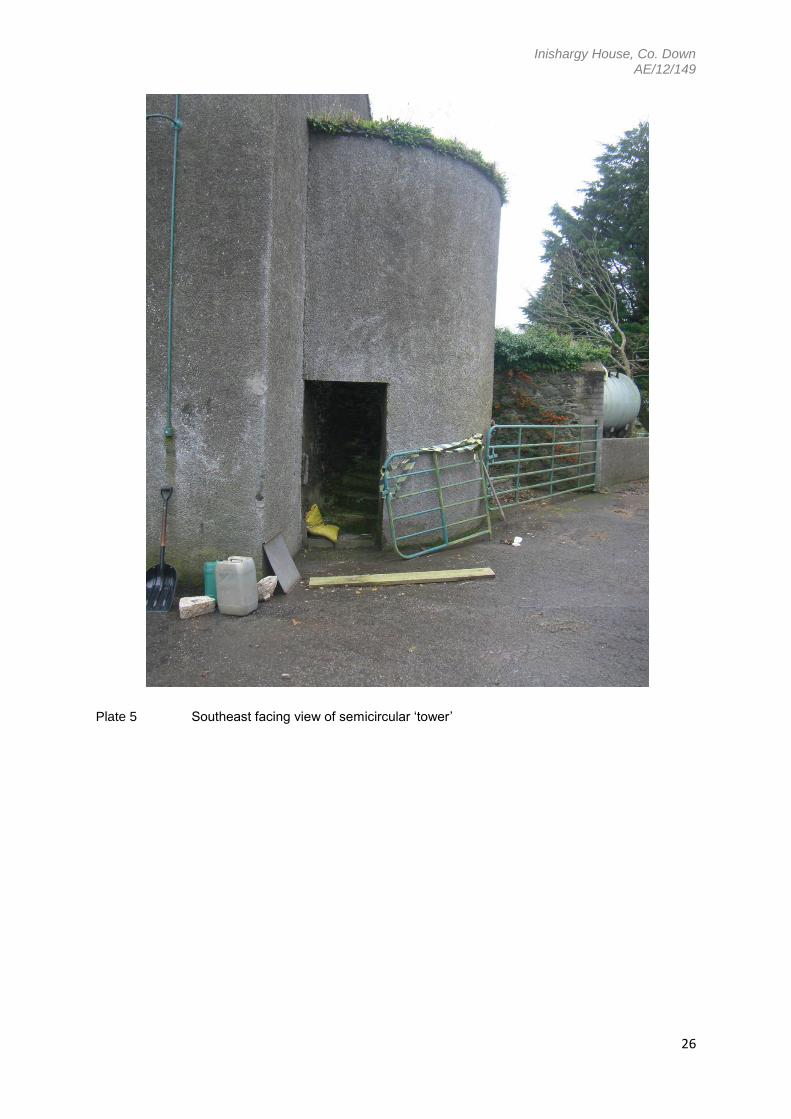
3.3 To the current rear of the house (its east face) are a series of stone buildings sited around a
yard of poured concrete (Plate 2). These buildings now used as storage, farm buildings and
workshops are likely to have been originally used as coach houses, stables and offices
serving the 17th-18th century occupancy of the house. Attached to the range of out-buildings
are the remains of what appears to be a stone tower with narrow lights which may be
perceived as gun loops (Plate 5). It has been speculated that this may indicate the remains of
a bawn at the site (Robinson and Oram 1983, 26). However, its central location in the gable
wall of an out-building and the turning of the stair in an-anti clockwise direction, which would
not be of particular use in defence (Plates 5 & 6), suggest that it is a folly built alongside the
house in the 17th century. It may also be worth noting that the stairs appear to be concrete or
concrete covered (Plate 6).
3.4 The house as it stands is by all appearances modern with 20th-century windows and roof
slates, plastic guttering, concrete-brick facing covered with modern render, and modern brick
chimneys (Plates 2-4). However, beneath this it can be seen that it is composed of large
rough stones and mortar (Plate 13). A free standing cross-wall (Plates 9-12) topped with a
skim of concrete, which stood perpendicular to the southern wall of the house, contained in its
western face, a number of brick arches blocked up with brick, stone and mortar (Plates 9 &
10). It is speculated that these arches represented the remains of two brick ovens and a
fireplace. This wall was found to be structurally unsound with large cracks, holes and falling
away in places and has since been removed (Plates 9-14).
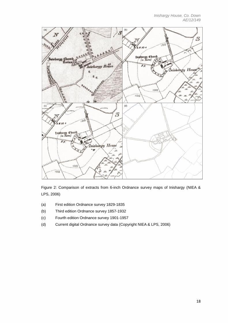
4.0 Cartographic evidence
4.1 The House
The first edition Ordnance Survey map of 1835 (Figure 2a) shows Inishargy House in a very
pronounced H-form along an east-northeast to west-southwest alignment with a small annexe
to its northern side. The third edition map of 1932 shows the building as a completely different
shape, seemingly without its H-form and with two possible extensions to the north-eastern
face, and possibly a wall running in an arc from the south-eastern side of the house towards
the yard (Figure 2b). The fourth edition map of 1957 shows the house with additions still
remaining to the north-eastern face. The possible wall to the southeast is now removed and
an extension or wall has been added to the south-western face (Figure 2c). The current OS
data available (2006) shows two extensions to the house; one at its eastern corner and one
almost centrally placed within the south-western face-it appears that all previous extensions
have been replaced or removed (Figure 2d). The H-form may be absent or obscured from
these latter maps due to the presence of an in-filling extension to the north-eastern face. This
Inishargy House, Co. Down AE/12/149
8
extension was partly still in place during the course of the excavation and has since been fully
removed.
4.2 The entranceways
Three entrances to the site coming from the north, east and south can be noted on the first
edition Ordnance Survey map of 1835; the northern entrance appears substantial and tree-
lined and enters the yard on the eastern side. A wide straight entranceway with trees lining its
northern edge runs directly from the eastern end of the yard and centrally in line with the
house (in an east-northeast to south-southwest direction). A winding laneway exits the site at
the south, between the yard buildings and the house before curving round to join the road to
the southwest (Figure 2a). From the third edition Ordnance Survey map of 1932 and onwards
three entranceways are clearly shown although the eastern entrance is gone and a new
laneway approaches from the road to the west. The western laneway cuts through the
enclosure and passes between the church ruins and the house before entering the yard
(Figure 2b). The fourth edition map of 1957 shows it passing in front of the house and joining
the southern laneway before it enters the yard (Figure 2c). However it appears that by present
day, it has been reverted back to its original position, passing between the house and the
church ruins (Figure 2d).
4.3 The church and enclosure
The church (DOW 018:001) is shown to be in ruins on all cartographic representations of the
area since the first edition Ordnance Survey map of 1835 (Figure 2). From the third edition of
1932 and onwards, only the remains of three walls are depicted; the northern, southern and
western. Two small stone buildings or towers are depicted set into corners of the wall which
surrounds the church (Figure 2). An enclosed area of trees and shrub to the east of the
church and shown only on the first edition ordnance Survey map of 1835, may represent an
associated graveyard (Figure 2a); there appears to be no further cartographic evidence of a
graveyard at the site. The large enclosure of unknown date which encircles the house, church
and yard is depicted from the third edition of 1932 and onwards. It appears as a wide belt of
trees; up to 12m in width, running from the northern edge of the church in a circular fashion
around to the east where it has been obscured or removed by the construction of the yard
and buildings (Figure 2).
4.4 The yard, buildings and other features
The yard buildings appear as two long ranges running parallel with the axes of the house.
They appear to have undergone few minor changes up until 1932. Post 1932 the yard
appears to have been developed more substantially with the addition of farm buildings and a
silo (Figure 2d). Field boundaries around the site have seen minor changes since the early
Inishargy House, Co. Down AE/12/149
9
1800’s, mainly due to the addition or removal of entranceways or drainage and reclamation of
marshland at the base of the drumlin. A well is shown centrally within the yard on the third and
fourth edition maps of 1932 and 1957 respectively.
5.0 Summary phasing of Inishargy House (Figure 5)
5.1 Early 17th century
Circa 1620, Alexander Baillie built a dwelling house here following the H-form of
contemporary English fashions (Robinson and Oram 1983, 26), (Figures 3 & 4). The main
entrance to the house is in its eastern face. It is not known what, if anything, stood on the site
prior to this date.
5.2 Late 17th century - 18th century
The house is likely to have been damaged or partly destroyed during the Irish Rebellion of
1641 as references are made to a late 17th-century rebuild (still in a H-form) (Robinson and
Oram 1983, 26). Destruction of the southern wing may have been so extensive that it was
never fully built back (Figure 4). Sash windows of Georgian style were added with panes of
six over six. The eastern side of the house was no longer used as the main entrance and a
new main entranceway was opened in the western side of the house. Windows were added to
the western face of the southern range to create symmetry in the new front face of the house.
A chimney which served fireplaces in the western wall of the south range fell into disuse and
had its intramural flues removed for the subsequent addition of these windows (Figure 4). A
high wall may have been constructed at this time, extending from the dilapidated south range
of buildings towards the yard buildings thereby further enclosing the yard. It seems possible
that the original front face of the house (east) was so badly damaged and beyond cost
effective repair that the most likely solution was to move the main entrance to the western
side of the building.
5.3 19th century
The sash windows were replaced or repaired with larger panes of four over four (Plate 1).
5.4 Late 19th – early 20th century
The house becomes uninhabited and falls into a state of disrepair. The house is then bought
by the current owners (The Coulters), (Plate 1).
5.5 Mid 20th century

Inishargy House, Co. Down AE/12/149
10
The entire south range of buildings was completely demolished with the possible exception of
its originally internal cross-wall, and a wall extending towards the yard buildings (Possibly
constructed in the 18th century) (Plate 2). The cross-wall contained the remnants of two
possible brick-built ovens and a brick-built fireplace (Plates 9-10). A new chimney, possibly
reusing original flues, was constructed where the southern range of buildings once met the
central range (now the southern gable wall of the house). Two windows visible within this new
gable wall may have marked the original position of two internal doorways (Plate 2). A narrow
poured concrete walkway delineated the footprint of the newly renovated residence. The sash
windows were all removed and new, larger windows were inserted, not following the
placement of the former windows (Plate 2). The roof was replaced and two extensions were
made to the rear (east face of the house). The southernmost of these incorporated the
original cross wall of the house (Plate 3).
5.6 Mid-Late 20th century
Further extensions were made to the house. A conservatory was added to the southern
gable, built up against but not incorporating the cross wall of the old house; It is likely that the
cross-wall would have been demolished at this stage if it were not still being used as a wall
incorporated into an earlier-built extension. The lower-floor window in the southern gable was
converted into a doorway for access from house to conservatory. An extension was made to
the front of the house, enclosing the front door (Plate 4). Further extensions were made to the
rear, eastern face of the house, and joining two earlier-built extensions.
5.7 Early 21st century
All 20th century extensions were demolished along with the original cross-wall of the house
leaving only the core of the original building in place (Plates 13-16).
5.8 2012-2013
Planning permission was applied for and received and foundations were dug for a new large
extension to the house, covering the footprint of the demolished 17th-century wing (Plate 26).
17th-century brick flooring and cobbled surfaces were found to be intact beneath layers of
concrete (Plates 20-22). Remnants of these should still be found mostly intact beneath the
new extension. The new extension should restore the house to H-form, mimicking its original
ground plan.

Inishargy House, Co. Down AE/12/149
11
6.0 Account of the excavation and monitoring
6.1 During the primary phase of investigation at the site, the cross-wall containing a hearth and
ovens, identified during a preliminary visit by a member of the NIEA Built Heritage
Inspectorate team (Liam McQuillan), was still in situ (Plates 9-12). For simplicity, the
excavation at this stage was divided into two areas; Area 1-west of the cross-wall (Figure 6)
and Area 2-east of the cross-wall (Figure 7). It was anticipated that the excavation could
reveal the remains of cellars rumoured to be below the house. Phases of demolition at the
site had left the area covered in a large amount of rubble material which was first removed,
along with a still intact concrete floor, by a mechanical excavator. The primary phase of
investigative excavation revealed within Area 1, a series of low brick ‘walls’ and a brick and
slate-topped stone wall running in to the garden area west of the house. Excavation of Area 2
revealed a brick floor, levelled brick wall, cobbled surface and the remains of a robbed-out
stone wall. During the second phase of monitoring at the site, the stone wall found in Area 1
was further uncovered.
Phase 1; Excavation
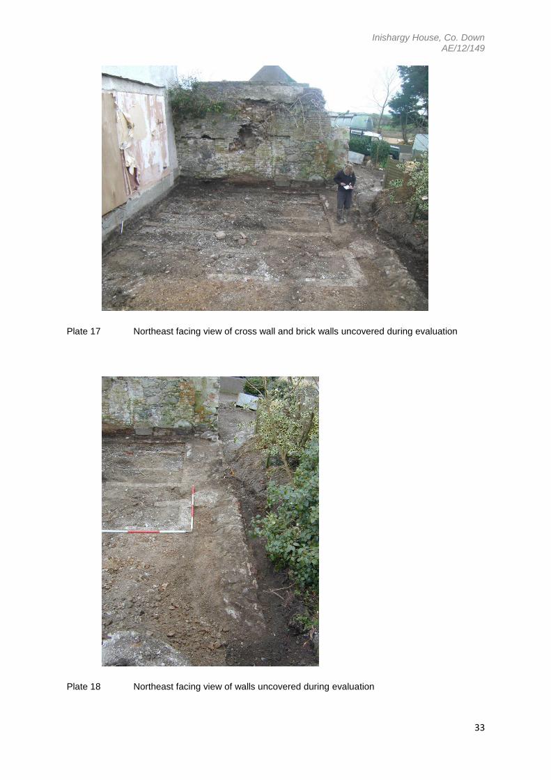
6.2.0 Area 1
Area 1 measured approximately 6m x 7.5m, extending over the site west of the cross-wall
where the southern range of the building once stood (Figures 5 & 6). The area was cleared of
loose rubble, mortar and debris which most likely resulted from demolition of a single-storey
20th-century conservatory extension which stood here. The outline of this conservatory can
clearly be seen in the face of the south-western wall of the house along with a doorway. Level
rows of brick and mortar were uncovered after clearing back the area. The spaces between
the brick rows or ‘walls’ was filled with loose, beige, mortar-rich material, broken brick, and
stone. It is unlikely that they formed part of the original structure of the house as the brick
used does not appear to be of much antiquity, unlike the 17th-century brick found in Area 2.
The presence of cellars in this area was neither ruled out nor confirmed by the investigation
and it is possible that these brick ‘walls’ were built on the top of the earlier walls or pillars of a
17th-century cellar system in order to create a level plinth for the base of the 20th-century
conservatory. The maximum dimensions of the area of brick ‘walls’ mirrored that of the now
removed conservatory (Plates 17-19, Figure 6) although the tops of the ‘walls’ appeared to be
substantially lower than would be expected of a levelling plinth for the conservatory. One
possible explanation for this is that the upper courses of these brick ‘walls’ had been removed
prior to commencement of the excavation; their original height probably coincided with the
level of the soil in this area as seen against the cross-wall. A stone wall capped with brick,
slate and mortar was found running parallel to the southern wall of the house and into the
garden at its front (western face), (Figure 6). The main fabric of this wall is roughly cut stone

Inishargy House, Co. Down AE/12/149
12
bonded with mortar and it is likely that it once stood to a much greater height before being
levelled to the same height as the brick walls.
6.3.0 Area 2
Area 2 measured approximately 6m x 7.5m and extending over the site east of the still
standing cross wall and covering the area where the southern range of buildings would once
have stood (Figures 5 & 7). The area was first cleared of larger debris and rubble by
mechanical excavator and the remains of a concrete floor was removed (Plate 20). This floor
represented the base of a 20th century extension and abutted the face of the cross wall which
had been roughly plastered on this (eastern) face (Plate 21).
6.3.1 Excavation of the area then proceeded by hand and revealed a brick floor under a thin layer
of grey silt preserved directly below the concrete floor, and a cobbled surface beneath a layer
of sticky grey clay (Plate 21). The clay pressed into the spaces between the cobbles and
contained much 19th-20th century household waste including broken ceramics and iron nails.
The brick surface measured at its maximum 3.5m by 11.5m with the bricks (measuring 22cm
length and 6cm depth) laid on their sides and end to end with a dark brown-black silt
between. The bricks had been tightly packed with maximum spaces measuring 0.5cm, to
create a level floor. A natural formation of a wavy pattern arising from the methods used in the
laying of the brick could be observed (Plate 22, Figure 7).
6.3.2 At the west, the brick floor was built up to the face of the cross wall, its northern edge could
not be observed as it continued below the level of a still standing 20 th century extension
(Plates 21 & 22). To the south it ended abruptly in an almost straight edge and appeared to
have been disturbed by the removal of a wall along this edge (Plate 23). A band of loose light
yellow-brown mortar approximately 0.6m in width was found running along this edge and
perpendicular to the cross wall (Plate 23), possibly the remains of a continuation of the stone
wall found in Area 1.
6.3.3 The eastern edge of the brick floor was bounded by the foundation courses of a mortared
brick wall measuring 0.35m width and 4.5m length (Plate 24). It is likely that this formed the
eastern wall of a now demolished 20th century extension, whether or not it was built at this
time or belonged to an earlier structure is not certain. It may be worth noting that it does not
run perfectly parallel with the 17th century walls of the house, nor with the patterning in the
cobbles (Figure 7). The mortared brick used in the wall certainly appears to be of a much later
date than the brick used in the adjacent floor. The dimensions of the mortared bricks also
matched those found in Area 1; 23cm length, 12cm width and 8cm depth and were bound
together with a compact pale grey mortar. The remains of this wall separated the brick floor
from the cobbled surface (Plate 24, Figure 7).
6.3.4 The cobbles likely form part of the original surfacing of the yard and the remains of patterns

Inishargy House, Co. Down AE/12/149
13
made in their laying could be observed (Plate 21, Figure 7). The cobbles measured up to
10cm in diameter and were set into a levelling deposit of dark grey clay which, if removed,
exposed the natural orange boulder clay subsoil of the site. The cobbles continued under the
modern concrete surface of the yard to the north and were heavily truncated and mostly
removed towards the south and east (Plate 21).
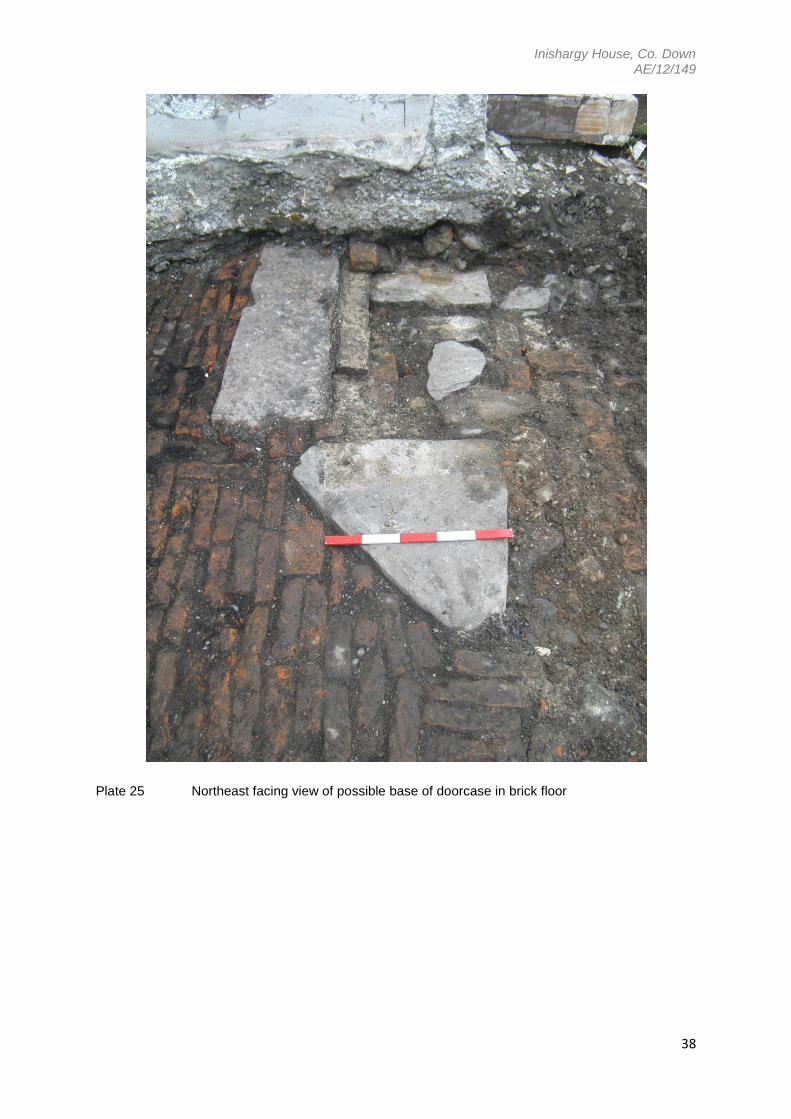
6.3.5 At the northernmost part of the brick surface were situated three large flat stones around a
jumble of mortared brick of the type used in the construction of the wall, smaller stones, and
slate (Plate 25, Figure 7). The larger stones possibly formed part of an original doorway, the
northern and southernmost of these stones sit either side of a larger rectangular cut stone
and bear the remains of iron pegs and mortar on their surfaces (Figure 7), which could
indicate that they once upheld solid structure. On their western and southern sides the brick
of the 17th century floor buts up against them; it is uncertain whether the brick floor was
altered to allow for the placing of these large stones or if its construction was secondary to
this (Plate 25). The space enclosed by these stones and the area directly to their east and
north has been much disturbed and partly infilled with loose mortar, mortared brick, small
stones and slate.
6.3.6 The original relationship between the large stones and the cobbled surface cannot be
ascertained due to the disturbance of the ground between them. The mortared brick wall is
also likely to be a later addition replacing an earlier wall and thereby obscuring the original
relationship between the brick floor and the cobbled surface. Monitoring of the mechanical
excavation of foundations for the new extension took place at the later date of 28 th January
2013.
Phase 2: Archaeological Monitoring of foundation digging
6.4.0 Six linked trenches were dug into the natural subsoil of the site to a depth of approximately
0.8m for the pouring of concrete for the foundations of the new wing (Plates 26-35, Figure 8).
The foundations were dug using a mechanical excavator with a 750mm toothed bucket with
the exception of the new cross wall which is to be slightly narrower (Plate 27) and was dug
using a 600mm straight edged bucket. It was hoped that although the old cross wall
containing ovens had been removed, its foundations may still remain providing insight into its
construction. However, during recording of the site prior to the cutting of the new foundations
it was observed that the wall had been removed in its entirety along with the edge of the brick
floor which ran along its length. The void left by its removal had been backfilled with a mixture
of redeposited orange subsoil, mortar and rubble; no original foundations or associated cuts
could be seen (Plate 28). Whether or not the cobbled surface east of the brick floor was still in
place could not be certain as the area was much obscured by a layer of clay, rubble and
mortar which had been spread across the site by mechanical excavator. The brick

Inishargy House, Co. Down AE/12/149
14
walls/levelling plinth which had been uncovered on the western side of the cross wall was
also largely obscured (Plate 26). Orange subsoil was encountered close to the surface across
the site. The upper levels of the subsoil are mottled grey and orange whereas the lower levels
(below 0.5m) are a more definite bright orange. This is most likely due to natural leaching of
the ground soils of the site.
6.4.1 The first cutting was for the planned new north-west facing wall. The edge of the brick floor
was disturbed in the process (Figure 8). No remains of the brick wall which separated the
brick floor from the cobbled surface, nor of the cobbles themselves, were observed;
presumably the brick wall had been removed prior to excavation of the foundations, and the
cobbled surface, which lay just beyond the boundaries of the new extension, was obscured by
a layer of rubble and clay spread across the site by mechanical excavator. The brick floor was
found, as in the first stage of investigations, to be set onto a thin levelling deposit of dark grey
clay which lay directly above the natural subsoil of the site. No further features or artefacts of
archaeological interest were noted.
6.4.2 The second cutting was for the planned new north-east facing wall. This was located over the
line of the brick wall running along the edge of the brick floor. However no remains of this wall
were observed and the presence of redeposited natural clay intermixed with concrete rubble
and mortar, in its place, would suggest that this feature was fully removed prior to official
excavation of the foundations. Removal of this rubble and clay layer revealed the natural
orange clay subsoil of the site. No features or artefacts of archaeological interest were
uncovered.
6.4.3 The third cutting was that of the planned new cross-wall of the development (Plate 27); this
was done using the narrower 600mm straight edged bucket. The original edge of the brick
floor which would have run along the edge of this trench had already been disturbed in the
prior removal of the old-cross wall and its foundations (Plate 28). The resultant arbitrary edge
had to be removed in the cutting of the new foundation trench and the bricks from the
remaining 17th century floor, were again found to be set onto a thin levelling deposit of dark
grey clay which was set directly on the natural subsoil of the site. No foundations of the
original cross-wall or further features or artefacts of archaeological interest were observed.
6.4.4 The fourth cutting was for the planned new south-east facing wall (Plate 29). Here, a mortared
stone and brick wall was discovered running parallel with the southern gable of the house and
roughly in line with a wall extending westwards from the yard buildings (Plates 30-34). What
appears to be a foundation cut measuring 0.26m in width was observed at the base of the
wall (Plates 31-33). This was filled with loose dark brown loamy clay and cobblestones.
Impressed into the top of this layer was a loosely wound ball of grey synthetic twine. Orange
clay was found packed around the wall. The wall extended beyond the line of the western
face of the house and into the garden (Figure 8). Its extent towards its south-western end is
unknown as it is buried beneath layers of garden soils. Its position within the site could point
Inishargy House, Co. Down AE/12/149
15
to the supposition that it represents the remains of the demolished southern wing of the
house; however its protrusion beyond the front of the 17th century house and its depth below
foundation level for the house would contradict this. It is likely to be later that the original
house structure and probably once formed part of a high garden wall. Certainly, the only find
of a synthetic ball of twine near its base would suggest a later date of construction or
alteration.
6.4.5 The fifth cutting was for the planned new southwest facing wall and its short return into the
current front face of the upstanding house. Placement of the foundations appears to indicate
that this new wall will sit marginally further west than the already existing northern wing of the
house (Plate 34). Excavation of this trench revealed a demolition layer of mixed materials;
concrete rubble, mortar, brick, stone, tarmac and road chippings. Removal of this revealed the
natural orange clay subsoil of the site beneath. No further features or finds of archaeological
significance were noted.
7.0 Conclusions and Recommendations
As can be observed and is evidenced from cartographic records (Section 4), and proposed
summary phasing (Section 5), Inishargy House has undergone various episodes of alteration,
rebuild and modification. Archaeological investigation and monitoring carried out at Inishargy
House (Section 6), has indicated that despite these successive episodes of alteration and
destruction, much of the original 17th century fabric still remains beneath layers of modern
render and concrete. Unfortunately the cross-wall which contained brick ovens and a fireplace
has since been demolished but the original 17th century brick floor which was uncovered
should still remain largely intact beneath the new rebuild of the southern wing. The cobbled
yard is also likely to remain mostly intact beneath the poured concrete surface of the modern
yard.
7.1 No finds of archaeological significance were noted during investigations and it is not
foreseeable that further post-excavation analysis of artefact material will be necessary. No
further archaeological work is to be carried out prior to erection of the southern wing rebuild,
however, if future building work or alteration is planned, further archaeological investigation
and monitoring of foundations would be recommended.

Inishargy House, Co. Down AE/12/149
16
Acknowledgements
Dr Emily Murray of the Centre for Archaeological Fieldwork directed the primary phase of excavation.
Assistance was also provided by Dr Henry Welsh (also of CAF). Original photographs and information
regarding the site were kindly provided by the current owners of Inishargy House (The Coulters).
References
Robinson, P. and Oram, D. 1983 Inishargie: some notes and ideas concerning this historical site.
Journal of the Upper Ards Historical Society 7, 26-8.
Web resources
NIEA SMR http://apps.ehsni.gov.uk
Excavations Bulletin: http://www.excavations.ie
NIEA Map viewer (Northern Ireland Environment Agency & Land and Property Service Copyright
2006): http://maps.ehsni.gov.uk
Archive
Finds: All artefact material is currently archived at the Centre for Archaeological Fieldwork, Queen’s
University Belfast, it is not foreseeable that further post-excavation analysis will be necessary.
Photographs: Original photographs returned to the owners of Inishargy House, Digital images held by
the Centre for Archaeological Fieldwork, Queen’s University Belfast.
Plans/Drawings: Digital plans of the site, held by the Centre for Archaeological Fieldwork, Queen’s
University Belfast and included with this report.

Inishargy House, Co. Down AE/12/149
17
Figure 1: Map showing the location of Inishargy house and church (NIEA & LPS, 2006)
Inishargy House, Co. Down AE/12/149
18
Figure 2: Comparison of extracts from 6-inch Ordnance survey maps of Inishargy (NIEA &
LPS, 2006)
(a) First edition Ordnance survey 1829-1835
(b) Third edition Ordnance survey 1857-1932
(c) Fourth edition Ordnance survey 1901-1957
(d) Current digital Ordnance survey data (Copyright NIEA & LPS, 2006)

Inishargy House, Co. Down AE/12/149
19
Figure 3: Ground plan of Inishargy House (Robinson & Oram 1983)
Figure 4: Illustration of Inishargy House before modernisation, looking northeast and showing
the southern wing in ruins (Robinson & Oram 1983)
Inishargy House, Co. Down AE/12/149
20
Figure 5: Summary phasing of alterations to Inishargy House, also showing the limit of the excavation area and outline of new foundations

Inishargy House, Co. Down AE/12/149
21
Figure 6: Area 1, with additions as uncovered during monitoring of foundation trenches

Inishargy House, Co. Down AE/12/149
22
Figure 7: Area 2, east of the 17th century cross wall

Inishargy House, Co. Down AE/12/149
23
Figure 8: Plan of foundations for new extension overlying earlier structural remains. Features lying within new foundation limits (marked in green) have since been
removed. The cross wall was also removed (prior to excavation of the foundations). Foundation cuttings numbered 1-5 according to discussion given in Section 6.4

Inishargy House, Co. Down AE/12/149
24
Plate 1 East facing view of Inishargy House as it stood when purchased by current owners in
the early 20th century (photo: landowner’s personal collection)
Plate 2 Aerial view of Inishargy House, yard and out-buildings, looking northeast, dated 1966.
Church ruins visible on the left (photo: landowner’s personal collection)

Inishargy House, Co. Down AE/12/149
25
Plate 3 Southwest facing view of Inishargy House in the mid 20th century (photo: landowner’s
personal collection)
Plate 4 Northeast facing view of Inishargy House in the late 20th century (photo: landowner’s
personal collection)
Inishargy House, Co. Down AE/12/149
26
Plate 5 Southeast facing view of semicircular ‘tower’

Inishargy House, Co. Down AE/12/149
27
Plate 6 Stairs and ‘gun-loop’ in the semicircular ‘tower’

Inishargy House, Co. Down AE/12/149
28
Plate 7 Stone mouldings and reused cut stone in the vicinity of Inishargy House
Plate 8 Stone mouldings found lying in the vicinity of Inishargy House

Inishargy House, Co. Down AE/12/149
29
Plate 9 Northeast facing view of wall containing blocked up ovens and a fireplace
Plate 10 Northeast facing view of blocked up oven in 17th century cross wall

Inishargy House, Co. Down AE/12/149
30
Plate 11 Northwest facing view of the top of the southern end of the 17th century cross wall
Plate 12 Northwest facing view of the base of the southern end of the 17th century cross wall

Inishargy House, Co. Down AE/12/149
31
Plate 13 Northwest facing view of corner of Inishargy House post removal of the cross wall
Plate 14 Northwest facing view of corner of Inishargy House post removal of the cross wall

Inishargy House, Co. Down AE/12/149
32
Plate 15 Southwest facing view of Inishargy House post removal of extensions
Plate 16 Northwest facing view of Inishargy House post removal of extensions
Inishargy House, Co. Down AE/12/149
33
Plate 17 Northeast facing view of cross wall and brick walls uncovered during evaluation
Plate 18 Northeast facing view of walls uncovered during evaluation

Inishargy House, Co. Down AE/12/149
34
Plate 19 Southwest facing view of walls uncovered during evaluation
Plate 20 Southwest facing view of site mid-clearance of rubble and concrete flooring

Inishargy House, Co. Down AE/12/149
35
Plate 21 View from above and looking southwest of brick floor and cobbled surfacing
Plate 22 View from above of brick floor

Inishargy House, Co. Down AE/12/149
36
Plate 23 Southwest facing view along line of removed wall and edge of brick floor

Inishargy House, Co. Down AE/12/149
37
Plate 24 Northeast facing view along line of levelled brick wall
Inishargy House, Co. Down AE/12/149
38
Plate 25 Northeast facing view of possible base of doorcase in brick floor

Inishargy House, Co. Down AE/12/149
39
Plate 26 North facing view of site, pre-excavation of foundations
Plate 27 Northwest facing view of third foundation cut, pre-excavation, along the line of the
now removed cross wall

Inishargy House, Co. Down AE/12/149
40
Plate 28 Northwest view of arbitrary edge of brick floor created by prior removal of original
cross-wall, within the third foundation cut, pre-excavation of foundations.

Inishargy House, Co. Down AE/12/149
41
Plate 29 Northeast facing view of site pre-excavation of foundations

Inishargy House, Co. Down AE/12/149
42
Plate 30 Southwest facing view of fourth foundation cut and uncovered wall, mid-excavation

Inishargy House, Co. Down AE/12/149
43
Plate 31 Northeast facing view of fourth foundation cut and uncovered wall, mid-excavation
Plate 32 West facing view of fourth foundation cut and uncovered wall, mid excavation

Inishargy House, Co. Down AE/12/149
44
Plate 33 Southwest facing view of fourth foundation cut, post removal of section of wall which
encroached on new extension foundations
Plate 34 Northwest facing view along line of house and fifth foundation cut