initial evaluation of bedrock geology and economic ... · and int ermontane morphogeol ogica l...
TRANSCRIPT

Initial Evaluation of Bedrock Geology and Economic MineralizationPotential of Southern Whitesail Lake Map Area (NTS 093E/02, 03), West-
Central British Columbia
By J.B. Mahoney1, R.L. Hooper1, S.M. Gordee2, J.W. Haggart3 and J.K. Mortensen2
KEYWORDS: Whitesail map area, Bella Coola map area,economic mineralization, Hazelton Group, Monarchassemblage, Coast Plutonic Complex, layered maficintrusion, volcanogenic massive sulphide deposits, EskayCreek, Rocks to Riches program
INTRODUCTION
Regional Geological Setting
The east ern Bella Coola (NTS 093D) and south ernWhitesail Lake (NTS 093E) 1:250 000 map ar eas com prisea re gion of rug ged moun tain ous to pog ra phy and lim ited ac -cess on the east ern mar gin of the Coast Moun tains. Thesemap ar eas strad dle the tran si tion zone be tween the Coastand Intermontane morphogeological belts, and en com passthe bound ary be tween ig ne ous and meta mor phic rocks ofthe Coast Plutonic Com plex on the west and Ju ras sic andCre ta ceous vol ca nic-sed i men tary suc ces sions of south -west ern Stikinia on the east (Fig. 1, 2). Bed rock geo log i calmap ping and eco nomic min eral as sess ment in the east ernBella Coola (NTS 093D) map area have been the pri maryfo cus of the 2001–2004 Bella Coola Tar geted GeoscienceIni tia tive (TGI), a co or di nated fed eral-pro vin cial pro jectde signed to im prove un der stand ing of the geo log i cal evo -lu tion for this part of the cen tral coast re gion and as sess theeco nomic po ten tial of lit tle-known Me so zoic vol ca nic as -sem blages in the re gion (Haggart et al., 2004, and ref er -ences therein). Dur ing the 2004 field sea son, the geo log i cal frame work es tab lished by the Bella Coola TGI was ex -tended to the north, into the south ern Whitesail Lake maparea (NTS 093E/02, 03), un der the aus pices of the Rocks To Riches Pro gram, by a com bined re search team from theUni ver sity of Wis con sin – Eau Claire, the Uni ver sity ofBrit ish Co lum bia and the Geo log i cal Sur vey of Canada.
The pri mary area of in ter est in cludes the Fore sightMoun tain (NTS 093E/03) and Tesla Lake (NTS 093E/02)1:50 000 map sheets in the south-cen tral Whitesail Lakemap area, on the east ern side of the Coast Moun tains west
of Tweedsmuir North Pro vin cial Park (Fig. 1). This areacon tains Ju ras sic and Cre ta ceous vol ca nic suc ces sions onthe west ern edge of Stikinia that are known to hostvolcanogenic mas sive sul phide (VMS) min er al iza tionelse where in the Cor dil lera, as well as Ju ras sic to Eoceneplutonic bod ies along the east ern mar gin of the CoastPlutonic Com plex that are known hosts for a va ri ety of por -phyry de pos its (Woodsworth, 1980; Dawson et al., 1991;Diakow et al., 2001). Stream sed i ment geo chem is try (Re -gional Geo chem i cal Survey data; Lett et al., 2002), as so ci -ated MineMatch anom aly clus ters and MINFILE oc cur -rences sug gest the po ten tial for eco nomic min er al iza tion inboth Me so zoic volcanogenic suc ces sions of west ernStikinia and plutonic bod ies along the east ern mar gin of theCoast Plutonic Com plex (Fig. 1). This in ves ti ga tion in te -grates re gional bed rock map ping, strati graphic and struc -tural anal y ses, geo chron ol ogy, plutonic and vol ca nic geo -chem is try, and iso to pic anal y ses to doc u ment the re gionalgeo log i cal frame work and to pro vide a first-or der as sess -ment of the eco nomic min eral po ten tial in the area.
This re port briefly de scribes the ge ol ogy of the south-cen tral Whitesail Lake 1:250 000 map area (NTS 093E/02,03), doc u mented by de tailed bed rock map ping dur ing the2004 field sea son (Fig. 2). This bed rock map ping is a con -tin u a tion of re gional map ping con ducted to the south by the Bella Coola TGI pro ject (Haggart et al., 2004, and ref er -ences therein). The pre lim i nary re sults from this in ves ti ga -tion are in te grated with a de tailed anal y sis of HazeltonGroup vol ca nic stra tig ra phy in the east ern half of the TeslaLake 1:50 000 map area by Gordee et al. (this vol ume).
GEOLOGICAL SETTING
Volcanic Assemblages
Hazelton Group
Vol ca nic rocks of the Early and Mid dle Ju ras sicHazelton Group form a thick (>4 km), broadly bi modal vol -ca nic suc ces sion con sist ing of ba saltic and ba saltic an de -site flows interbedded with and over lain by dacitic torhyolitic tuff, lapilli tuff, tuff-brec cia, tuffaceous sed i men -tary rocks and as so ci ated rhyolitic domes and flows. Theserocks are wide spread and well pre served in the east ern third of the map area and oc cur in well-ex posed, gen er ally east -ward-younging, gently dip ping struc tural pan els along theeast ern mar gin of the Coast Plutonic Com plex. Pre lim i nary
Geo log i cal Field work 2004, Pa per 2005-1 291
1Department of Geology, University of Wisconsin – Eau Claire,Wisconsin, USA
2Mineral Deposit Research Unit, Department of Earth andOcean Sciences, University of British Columbia, Vancouver,BC
3Geological Survey of Canada, Vancouver, BC
strati graphic anal y ses sug gest that the stra tig ra phy, com po -si tion, age and fa cies ar chi tec ture of the Hazelton Group inthis re gion strongly re sem ble strata that host the EskayCreek VMS de posit in the north west ern por tion of Stikinia(Diakow et al., 2001; Gordee et al., this vol ume). HazeltonGroup strata in this area are the fo cus of an on go ing strati -graphic, geo chem i cal and geochronological in ves ti ga tionby S.M. Gordee at the Uni ver sity of Brit ish Co lum bia. The
fol low ing de scrip tion is a syn op sis, and de tailedvolcanostratigraphic de scrip tions of Hazelton Group stratain the region are provided by Gordee et al. (this volume).
One of the most sig nif i cant re sults of the 2004 fieldsea son was the rec og ni tion that Hazelton Group strata aresub stan tially more wide spread in the area than sug gestedby ear lier re con nais sance map ping (i.e., Woodsworth,1980). Re gion ally, the Hazelton Group forms a gently east-
292 Brit ish Co lum bia Geo log i cal Sur vey
PALEOGENE TO NEOGENEContinental margin arc and younger intra-plate volcanic successions
STIKINE TERRANE TRIASSIC TO CRETACEOUS
Arc volcanic successions and associated sedimentary sequences
JURASSIC TO CRETACEOUS
PALEOZOIC TO JURASSIC
Arc-related granodiorite quartzmonzonite, lesser diorite
COAST COMPLEXEOCENE
Quartz diorite and tonalite
Older arc-related metavolcanic and metasedimentary rocks; migmatite and gneiss
93D93E53°00'
area of Figure 2
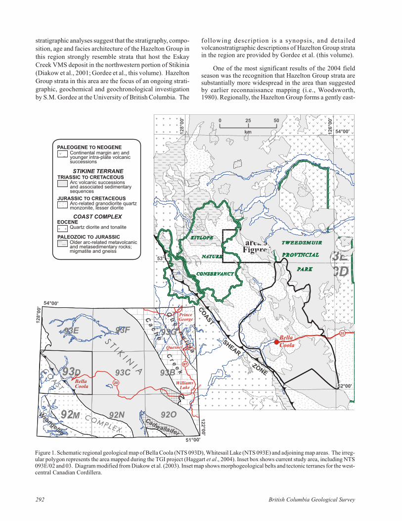
Figure 1: Schematic regional geologic map of Bella Coola (NTS 93D), Whitesail Lake (NTS 93E), and adjoining map areas. The polygon represents area mapped during TGI project (Haggart et al., 2004). Inset box shows current study area, including 93E02 and 93E03. Inset map shows morphogeologic belts and tectonic terranes for west-central Canadian Cordillera. Diagram modified from Diakow et al. (2003).
20
BellaCoola
54°00'12
6°0
0'
12
8°0
0'
52°00'
25 500
km
SHEAR
ZONE
CO
AST
93C
93F93E
D
M 92N
93G
93B
92O
54°00'
128°0
0'
51°00'
122°0
0'
BellaCoola
COMPLEX
C r e e k
Cadwallader
Wrangellia
ST I K
I NI AC
OA
ST
C a c h
e
93
92
PrinceGeorge
$Williams
Lake
Quesnel
$$
9797
2020
Q u
e s n e l l i a$$
$$
Fig ure 1. Sche matic re gional geo log i cal map of Bella Coola (NTS 093D), Whitesail Lake (NTS 093E) and ad join ing map ar eas. The ir reg -u lar poly gon rep re sents the area mapped dur ing the TGI pro ject (Haggart et al., 2004). In set box shows cur rent study area, in clud ing NTS093E/02 and 03. Di a gram mod i fied from Diakow et al. (2003). In set map shows morphogeological belts and tec tonic ter ranes for the west-cen tral Ca na dian Cor dil lera.
north east-dip ping homocline that can be crudely sub di -vided into two strati graphic pack ages. The basal pack agecon sists of a thick suc ces sion (>2000 m) of in ter me di ate tomafic vol ca nic flows, tuff-brec cias, lapilli tuffs and as so ci -ated me dium to coarse-grained volcaniclastic sed i men taryrocks that form the jag ged mas sifs of the Tsaydaychuz Peak – west ern Jum ble Moun tain area (Fig. 2). Hypa bys sal in tru -sions are com mon, and much of the area con sists of comp -lexly in ter ca lated ba salt and ba saltic an de site flows, dikesand sills, and as so ci ated tuffaceous strata in truded by abun -dant gabbroic to dioritic hypa bys sal in tru sions.
The ‘lower’ mafic as sem blage is gradationally over -lain by a very thick suc ces sion (>3000 m) of lat er ally ex ten -sive dacitic to rhyolitic tuff, lapilli tuff, tuff-brec cia and as -so ci ated volcaniclastic sed i ments (Fig. 3). This ‘up per’fel sic pack age makes up over 80% of the Hazelton Group in the area. The rocks are very well bed ded, and in di vid ualbeds can be traced for hundreds of metres along strike. Thepack age is dom i nated by ma roon to red, thin to me dium-bed ded, rhyolitic welded to unwelded tuff and lapilli tuff,peb ble to cob ble con glom er ate, vol ca nic lithic arenite andwacke; and mudstone interbedded with me dium to thick-bed ded lapilli tuff, tuff-brec cia and con glom er ate. The en -tire se quence fines up ward, with thin-bed ded mudstone,siltstone and sand stone dom i nat ing in the north ern andeast ern por tions of the map area.
In the Rivers Peak – Mount Pres ton area, an im pres sive se quence of apha ni tic rhy o lite flow domes in trudes thin to
me dium-bed ded volcaniclastic strata, and fol lows the traceof a down-to-the-south, ap par ently synvolcanic exten -sional fault. Both the fault zone and rhy o lite domes are ex -ten sively sericitized and ox i dized, form ing a very dis tinctred-stained gos san zone im me di ately south of Mount Pres -ton.
The age of the Hazelton Group in the south ernWhitesail Lake area is con strained by a com bi na tion of fos -sil ages and U-Pb geo chron ol ogy. The age of the base of theHazelton Group sec tion to the west of Tsaydaychuz Peak ispoorly con strained by the com bi na tion of a 191 ±?12 Ma U-Pb age from dacitic tuff un der ly ing the ma jor mafic in ter -val, and by an in tru sive con tact be tween Hazelton Groupstrata and the ca. 177 Ma Trap per Peak pluton (P. van derHeyden and G. Woodsworth, un pub lished data). Up sec -tion, in the Jum ble Moun tain area, fine to coarse-grainedfeldspathic lithic arenite and wacke have yielded a di verseas sem blage of bilvalves, gas tro pods, belemnoids andammonites that con strain the strata to Late Toarcian toEarly Aalenian age (T.P. Poulton, personal communication, 2003). This age des ig na tion is sup ported by a U-Pb zir conage of 176.6 ±?0.7 Ma, de rived from over ly ing rhyoliticlapilli tuff (R.M. Fried man, personal communication,2003). The Jum ble Moun tain area strad dles the con tact be -tween the ‘lower’ mafic and ‘up per’ fel sic strati graphicpack ages, sug gest ing that the tran si tion from ef fu sive ba -saltic vol ca nism to ex plo sive rhyolitic vol ca nism is roughly Aalenian in age. The cor re la tion between rhyolitic strata in
Geo log i cal Field work 2004, Pa per 2005-1 293
?
Km
Km
Km
Kmv
Kmv
Eg
Eg Er Jh
Jh
Jh?
lJsp
lJsp
~~~~
~~~~
~~~
~~~~~~
~~
~~~~
~~~~
~~~~
~~
~~
~~~~
~~~~
~~
~~
~~~~
~~~~
~~~~
~~
~~
~~~~
~~~~
Eg
eKd
eKd
eKd
eKd
eKd?
Kqdc
Kqdc
Kqdc
Kmvp
Kms
Kms
lJsp
Eg
lKfm
?
TrapperMountain
ForesightMountain
WhiteconePeak
CrawfordPeak
Price Pk
ChatsquotMountain
MountPreston
RiversPeak
ButlerPeak
TeslaMountain
TsaydaychuzPeak
RamseyPeak
JumbleMountain
GableMountain
MountCosgrove
ThumbPeak
SalientMountain
MountPondosy
Tesla Lake
PondosyLake
SalahagenLake
KimsquitLake
EarLake
o531 5"
o530 0"
o1273 0" o1263 0"
0 10km
Jh
Jurassic Hazelton Group
Hazelton volcanic/volcaniclastic rocks
Cretaceous Monarch Assemblage
Kqdc
Kmvp
Kms
Kmv
Km undivided
volcanic-dominated
sediment-dominated
volcanoplutonic
quartz diorite complex
Plutonic Rocks
Four Mile suite (ca 70 Ma)lKfm
granite (ca 50 Ma)Eg
Desire suite (ca 120 Ma)
Stick Pass suite (ca 150 Ma)
Trapper pluton (ca 175 Ma)
Fougner suite (ca 70 Ma)
mJt
lKf
lJsp
eKd
lKf
mJt
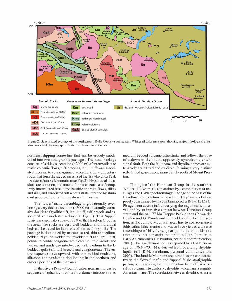
Fig ure 2. Gen er al ized geology of the north eastern Bella Coola – south eastern Whitesail Lake map area, show ing ma jor lith o logical units,struc tures and phys io graphic fea tures re ferred to in the text.

the Jum ble Moun tain area and those of the Mount Pres tonarea is pro vided by U-Pb ages of 176.3 ± 3.3 Ma and 175.4± 0.9 Ma, de rived from rhyolitic lapilli tuff from the baseand top of the Mount Pres ton sec tion, re spec tively (S.M.Gordee, work in prog ress). The youn gest Hazelton Groupstrata in the re gion are found to the east of the map area,where a Late Bathonian to Early Callovian fauna has beeniden ti fied near Oppy Lake (H. Frebold, un pub lished data).
Monarch Assemblage
The Lower Cre ta ceous Mon arch as sem blage is ex -posed in a se ries of north west-trending struc tural pan els inthe west ern and north ern por tions of the map area, and asero sional rem nants near Sa lient Moun tain in the south ernpor tion of the map area (Fig. 2). These ex po sures rep re senta con tin u a tion of the out crop pat tern in the Bella Coola areato the south, where vol ca nic strata of the Mon arch as sem -blage are ex posed in a se ries of im bri cate struc tural pan elsde vel oped to the west of the main Hazelton Group outcropbelt.
The base of the Mon arch as sem blage in the south ernWhitesail Lake map area is rep re sented by a prom i nent an -gu lar un con formity be tween rocks of the Hazelton Groupand ba saltic an de site and an de site of the Mon arch as sem -blage. The con tact is vis i ble on the south and east flanks ofSa lient Moun tain, where vol ca nic rocks of the Mon arch as -sem blage form ing the steep mas sif of Sa lient Moun tainover lie steeply dip ping fel sic strata typ i cal of the up perHazelton Group. The un der ly ing fel sic strata are in trudedby the ca. 177 Ma Trap per Moun tain pluton on the southside of Sa lient Moun tain, thus ver i fy ing as sign ment to theHazelton Group. This is the first lo cal ity where an un con -form able con tact has been iden ti fied be tween the Mon archas sem blage and the Hazelton Group. To the south, theM o n a r c h a s s e m b l a g eerosionally over lies both ca.155 Ma and ca . 134 Maplutonic rocks, but the con -tact be tween the Mon arch as -sem blage and older vol ca nicrocks in the east ern BellaCoola map area is equiv o cal(Haggart et al., 2004).
The Mon arch as sem -blage is dom i nated by ol ivegreen, lo cally amyg da loid alba salt, ba saltic an de site anddacite flows and as so ci atedbrec cias and tuff-brec cias, in -ter ca lated with dis tinc tive in -ter vals of argillite, siltstoneand vol ca nic lithic arenite towacke. The sed i men tary in -ter vals lo cally amal gam ate tosec tions hundreds of metresthick, and con tain thin to me -dium-bed ded lapilli tuff, vol -ca nic peb ble con glom er ate,me dium to coarse-grained
feldspathic lithic sand stone, and thin-bed ded tuff, siltstoneand rare lime stone interbeds. Sed i men tary interbeds aretab u lar and lat er ally con tin u ous, and lo cally may rep re sentamal gam ated par tial bot tom-cut-out turbidite beds. The lat -eral con ti nu ity, par tial turbidite se quences and pres ence oflime stone and fossiliferous in ter vals in di cate, at least inpart, a sub-wavebase ma rine depositional en vi ron ment.Stra tig ra phy within the as sem blage is com plex, how ever, are sult of abrupt lat eral fa cies changes com pli cated by struc -tural de for ma tion. The Mon arch as sem blage is dif fer en ti -ated from the Hazelton Group by its higher per cent age ofmafic amyg da loid al flows, lower amount of rhy o lite, over -all green chloritic color (con trast ing with the pre dom i -nantly red dish-pur ple cast of the Hazelton) and the pres -ence of lat er ally con tin u ous thin-bed ded argillite, siltstoneand sand stone in ter vals that form dis tinct marker ho ri zonsbe tween mas sive mafic flow pack ages.
In the west ern por tion of the map area, the Mon arch as -sem blage is ex posed within a se ries of struc tural pan els that are in ter preted to rep re sent an imbrication of sev eral dif fer -ent strati graphic-struc tural lev els within a sin glevolcanoplutonic arc as sem blage (Fig. 4). From the low eststruc tural level up ward, these pan els in clude 1) a fo li ated to nonfoliated hornblende quartz diorite com plex with meta -vol can ic xe no liths (10–20%) and abun dant mafic dikestrending roughly east-west; 2) meta vol can ic andmetasedimentary screens (40–50%) within a ‘ma trix’ oftex tur al ly and compositionally com plex, lo callymagmatically fo li ated bi o tite-hornblende, pyroxene-hornblende and hornblende diorite to quartz diorite(Fig. 5); 3) mas sive ba salt, ba saltic an de site and an de siteflows, as so ci ated tuff-brec cia and other fragmental rocks;and 4) volcaniclastic sed i men tary strata and as so ci atedpyroclastic rocks. These struc tural pan els are in ter preted to
294 Brit ish Co lum bia Geo log i cal Sur vey
Fig ure 3. Thick suc ces sion of rhyolitic tuff, lapilli tuff, and as so ci ated volcaniclastic sed i men taryrocks on the south end of Ga ble Moun tain. Note abun dant gos san as so ci ated with strata and as so ci -ated struc tures.

rep re sent ‘slices’ of a sin glevolcanoplutonic-arc as sem -blage, from the subvolcanicplutonic roots, through theplutonic-vol ca nic in tru sive con -tact, to the surficial vol ca nicf l o w s a n d a s s o c i a t e dvolcanogenic sed i men tary rocks (Fig. 2). In this suc ces sion, therheologically weak sed i men taryi n t e r v a l s t e n d t o f o r mdécollement sur faces, whereasthe mas sive flow units tend to bestruc tur ally re sis tant.
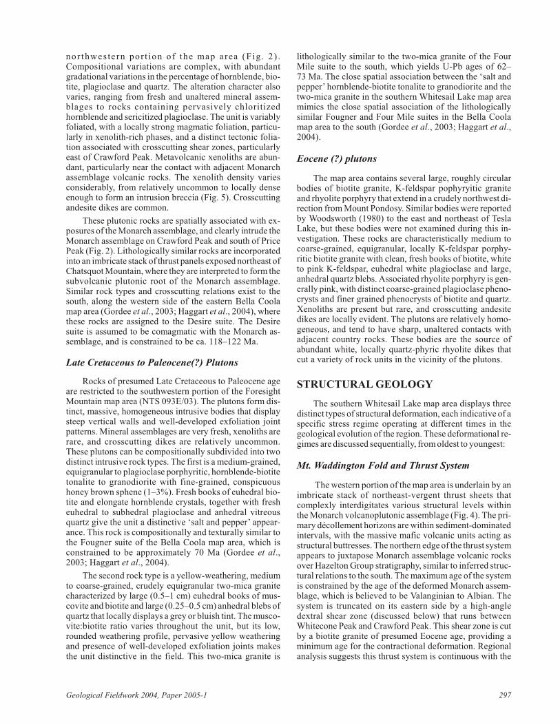
One of the struc tur ally re -sis tant struc tural pan els is ex -posed on Chatsquot Moun tainand the ridges im me di ately tothe south east and north west ofthe main mas sif, which har bourspec tac u lar ex po sures of a min -er al ized lay ered mafic in tru sion(LMI; Fig. 2). Compositionalband ing in the LMI is typ i callyde fined by vari able pro por tions of ol iv ine, pyroxene,plagioclase and mag ne tite, and ranges in com po si tion fromultra mafic mag ne tite-ol iv ine websterite to anorthositicgab bro. The prom i nent fo li a tion in the rock par al lels thecompositional lay er ing and re sults in a dis tinctly lay eredap pear ance vis i ble from sev eral ki lometres away. Typ i calcompositional lay ers are less than 1 m thick, withclinopyroxene (cpx)-rich gab bro (80% cpx) al ter nat ingwith more plagioclase-rich lay ers that dis tinctly weather toa lighter colour (Fig. 6). Sub or di nate ultra mafic lay ers in -clude mag ne tite and ol iv ine-rich rocks (ap par ent cu mu latelay ers), which weather to a dis tinc tive rusty brown, knobbysur face. Along the ridge north east ofChatsquot Moun tain, the LMI is cutby nu mer ous mafic and in ter me di atepor phyry dikes, which oc ca sion allyex ceed the LMI in vol ume and formin tru sion brec cias.
In the Bella Coola map area(NTS 093D), the Mon arch as sem -blage is in ter preted to be Valanginianin age, based on sparse ammonitecol lec tions from sev eral lo cal i ties(Struik et al., 2002). In the WhitesailLake map area, this in ter pre ta tion issup ported by a 124 ± 4 Ma K-Ar ageon hornblende from the top of George Peak, and by an im pre cise 128–136 Ma U-Pb age from the sum mit ofSa lient Moun tain (P. van der Heydenand G. Woodsworth, un pub lisheddata; Fig. 2). How ever, Albian ageshave been re ported from stratalithologically iden ti cal to the Mon -arch as sem blage from the Bella
Coola area (Haggart et al., 2004). Field work in the typearea of the Mon arch as sem blage on the south side of theMon arch Ice field, south of the Bella Coola (NTS 093D)map area, dur ing 2004 yielded fos sils of Albian age, in di -cat ing that the Mon arch as sem blage most likely rangesfrom Valanginian to Albian in age. It is un clear if this agerange en com passes a sin gle strati graphic suc ces sion or two(or more?) un con formity-bound suc ces sions. Fos sils col -lected east of Price Peak have been sub mit ted for iden ti fi ca -tion, and U-Pb geo chron ol ogy sam ples from rhyoliticlapilli tuff within the Mon arch as sem blage east ofChatsquot Peak are be ing analyzed.
Geo log i cal Field work 2004, Pa per 2005-1 295
Fig ure 4. Im bri cate thrust stack within Mon arch as sem blage and subjacent in tru sive rocks, north -east of Chatsquot Moun tain.
Fig ure 5. Clasts of meta vol can ic rocks from the basal Mon arch as sem blage withinhornblende diorite to quartz diorite. In tru sive rocks are pre sumed to be subvolcanicequivalent of Mon arch as sem blage. Rock ham mer for scale.
PLUTONIC ASSEMBLAGES
The cen tral por tion of the south ern Whitesail Lakemap area (NTS 093E/02, 03) is char ac ter ized by a west erly-in creas ing vol ume of plutonic rocks of Mid dle Ju ras sic toEocene age. The spa tial and tem po ral mag matic pat tern inthe south ern Whitesail Lake map area mim ics that of theBella Coola area to the south, which is char ac ter ized by anorth west-trending belt of plutonic rocks that is sub di vided into in tru sive suites on the ba sis of lith o logical char ac ter is -tics, cross cut ting field re la tion ships, min er al ogy, al ter ationas sem blages, geo chem i cal at trib utes and age (Gordee etal., 2003). Plutonic rocks in the study area have been sub di -vided on the ba sis of cross cut ting re la tions and li thol ogy,w i t h l i m i t e d g e o c h r o n o l o g y. G e o c h e m i c a l ,geochronological and iso to pic anal y ses are in prog ress.
Early Jurassic(?) Plutons
Cross cut ting re la tions along the mar gins of the Mid dleJu ras sic Trap per Peak pluton (see be low) in di cate that theold est plutonic rocks in the south ern Whitesail Lake maparea con sist of a tex tur ally and compositionally com plexsuite of hornblende diorite and quartz diorite. The unit dis -plays a wide tex tural vari a tion from fine grainedholocrystalline to lo cally peg ma titic. It is vari ably fo li ated,rang ing from unfoliated to comp lexly magmatically fo li -ated, and dis plays a strong tec tonic fo li a tion ad ja cent to theshear zone west of Whitecone Peak. Meta vol can ic maficxe no liths are com mon, rang ing from peb ble to boul der size, but gen er ally con sti tute less than 20% of the unit. To thesouth, in the Bella Coola map area, rocks lithologically sim -i lar to those in truded by the Trap per Peak pluton are re -ferred to as the Howe Lake suite, and yield U-Pb crys tal li -za tion ages of ca. 180–185 Ma.
Middle Jurassic Plutons
The old est dated plutonic rockin the south ern Whitesail Lake maparea is the Trap per Peak pluton,which is a me dium to coarse-grained, lo cally K-feldspar por phy -ritic hornblende-bi o tite gran ite. Therock is rel a tively fresh, with weakchloritization of hornblende andweak sericitization of plagioclasefeld spar. The unit is unfoliated, andap pears rel a tively ho mo ge neous on a re gional scale. The Trap per Peakpluton clearly in trudes andesitic vol -ca nic rocks of the Hazelton Groupalong its south east mar gin, and in -trudes tex tur ally com plex, lo cally fo -li ated hornblende diorite along itssouth ern and north east ern mar gins.Con tact re la tions with plutons on thenorth western and west ern sides aream big u ous. The Trap per Peak pluton yielded a 177.4 ± 0.7 Ma U-Pb zir con age (P. van der Heyden and G.
Woodsworth, un pub lished data). This age is only slightlyyoun ger than U-Pb ages ob tained from rhyolitic tuffs in theHazelton Group, and over laps paleontological ages fromthe up per por tion of the Hazelton Group stra tig ra phy. Theco eval na ture of the pluton and its spa tial as so ci a tion withthousands of metres of rhyolitic pyroclastic rocks and as so -ci ated rhy o lite domes strongly sug gest this pluton may rep -re sent the source magma chamber for rhyolitic volcanismin the upper Hazelton Group.
Late Jurassic (?) Plutons
Plutonic rocks of ap par ent Late Ju ras sic age form anorth west-trending belt be tween Tsaydaychuz Peak andSa lient Moun tain. These rocks are char ac ter ized by fine tome dium-grained bi o tite hornblende granodiorite to quartzdiorite. Aplite dikes are com mon, and small (<4–5 cm),strongly recrystallized mafic xe no liths are lo cally abun -dant. The unit is heavily frac tured. Hornblende is com -monly glomerocrystic and chloritized, and with wide -spread in ter sti tial pink K-feld spar im parts a dis tinct greenand pink tint to the rock. The unit clearly in trudes maficvol ca nic rocks of the Hazelton Group, and is in truded on itsnorth ern end by rhy o lite por phyry as so ci ated with theEocene (?) Mount Pondosy pluton. These rocks form thenorth ern con tin u a tion of a north west-trending belt oflithologically sim i lar rocks in the Bella Coola map area as -signed to the Stick Pass suite, which is con strained to be148–156 Ma (Gordee et al., 2003; Haggart et al., 2004).
Early Cretaceous (?) Plutons
One of the most abun dant plutonic suites in the south -ern Whitesail Lake map area is a tex tur al ly andcompositionally com plex as sem blage of fine to me dium-grained, hornblende to bi o tite hornblende granodiorite,quartz diorite and tonalite that is pri mar ily ex posed in the
296 Brit ish Co lum bia Geo log i cal Sur vey
Fig ure 6. Typ i cal compositional lay er ing of plagioclase-rich (lighter) bands and pyroxene-rich (darker) bands within the lay ered mafic in tru sion on Chatsquot Moun tain. Rock ham mer for scale
nor th wes t e rn por t ion of the map a rea (F ig . 2 ) .Compositional vari a tions are com plex, with abun dantgradational vari a tions in the per cent age of hornblende, bi o -tite, plagioclase and quartz. The al ter ation char ac ter alsovar ies, rang ing from fresh and un al tered min eral as sem -blages to rocks con tain ing per va sively chloritizedhornblende and sericitized plagioclase. The unit is vari ablyfo li ated, with a lo cally strong mag matic fo li a tion, par tic u -larly in xe no lith-rich phases, and a dis tinct tec tonic fo li a -tion as so ci ated with cross cut ting shear zones, par tic u larlyeast of Crawford Peak. Meta vol can ic xe no liths are abun -dant, par tic u larly near the con tact with ad ja cent Mon archas sem blage vol ca nic rocks. The xe no lith den sity var iescon sid er ably, from rel a tively un com mon to lo cally denseenough to form an intrusion breccia (Fig. 5). Cross cut tingandesite dikes are common.
These plutonic rocks are spa tially as so ci ated with ex -po sures of the Mon arch as sem blage, and clearly in trude theMon arch as sem blage on Crawford Peak and south of PricePeak (Fig. 2). Lithologically sim i lar rocks are in cor po ratedinto an im bri cate stack of thrust pan els ex posed north east of Chatsquot Moun tain, where they are in ter preted to form the subvolcanic plutonic root of the Mon arch as sem blage.Sim i lar rock types and cross cut ting re la tions ex ist to thesouth, along the west ern side of the east ern Bella Coolamap area (Gordee et al., 2003; Haggart et al., 2004), wherethese rocks are as signed to the De sire suite. The De siresuite is as sumed to be comagmatic with the Mon arch as -sem blage, and is con strained to be ca. 118–122 Ma.
Late Cretaceous to Paleocene(?) Plutons
Rocks of pre sumed Late Cre ta ceous to Paleocene ageare re stricted to the south western por tion of the Fore sightMoun tain map area (NTS 093E/03). The plutons form dis -tinct, mas sive, ho mo ge neous in tru sive bod ies that dis playsteep ver ti cal walls and well-de vel oped ex fo li a tion jointpat terns. Min eral as sem blages are very fresh, xe no liths arerare, and cross cut ting dikes are rel a tively un com mon.These plutons can be compositionally sub di vided into twodis tinct in tru sive rock types. The first is a me dium-grained,equigranular to plagioclase por phy ritic, hornblende-bi o tite tonalite to granodiorite with fine-grained, con spic u oushoney brown sphene (1–3%). Fresh books of euhedral bi o -tite and elon gate hornblende crys tals, to gether with fresheuhedral to subhedral plagioclase and anhedral vit re ousquartz give the unit a dis tinc tive ‘salt and pep per’ ap pear -ance. This rock is compositionally and tex tur ally sim i lar tothe Fougner suite of the Bella Coola map area, which iscon strained to be ap prox i mately 70 Ma (Gordee et al.,2003; Haggart et al., 2004).
The sec ond rock type is a yel low-weath er ing, me diumto coarse-grained, crudely equigranular two-mica gran itechar ac ter ized by large (0.5–1 cm) euhedral books of mus -co vite and bi o tite and large (0.25–0.5 cm) anhedral blebs of quartz that lo cally dis plays a grey or blu ish tint. The mus co -vite:bi o tite ra tio var ies through out the unit, but its low,rounded weath er ing pro file, per va sive yel low weath er ingand pres ence of well-de vel oped ex fo li a tion joints makesthe unit dis tinc tive in the field. This two-mica gran ite is
lithologically sim i lar to the two-mica gran ite of the FourMile suite to the south, which yields U-Pb ages of 62–73 Ma. The close spa tial as so ci a tion be tween the ‘salt andpep per’ hornblende-bi o tite tonalite to granodiorite and thetwo-mica gran ite in the south ern Whitesail Lake map areamim ics the close spa tial as so ci a tion of the lithologicallysim i lar Fougner and Four Mile suites in the Bella Coolamap area to the south (Gordee et al., 2003; Haggart et al.,2004).
Eocene (?) plutons
The map area con tains sev eral large, roughly cir cu larbod ies of bi o tite gran ite, K-feldspar pophyryitic gran iteand rhy o lite por phyry that ex tend in a crudely north west di -rec tion from Mount Pondosy. Sim i lar bod ies were re portedby Woodsworth (1980) to the east and north east of TeslaLake, but these bod ies were not ex am ined dur ing this in -ves ti ga tion. These rocks are char ac ter is ti cally me dium tocoarse-grained, equigranular, lo cally K-feldspar por phy -ritic bi o tite gran ite with clean, fresh books of bi o tite, whiteto pink K-feld spar, euhedral white plagioclase and large,anhedral quartz blebs. As so ci ated rhy o lite por phyry is gen -er ally pink, with dis tinct coarse-grained plagioclase pheno -crysts and finer grained pheno crysts of bi o tite and quartz.Xe no liths are pres ent but rare, and cross cut ting an de sitedikes are lo cally ev i dent. The plutons are rel a tively ho mo -ge neous, and tend to have sharp, un al tered con tacts withad ja cent coun try rocks. These bod ies are the source ofabun dant white, lo cally quartz-phyric rhy o lite dikes thatcut a variety of rock units in the vicinity of the plutons.
STRUCTURAL GEOLOGY
The south ern Whitesail Lake map area dis plays threedis tinct types of struc tural de for ma tion, each in dic a tive of a spe cific stress re gime op er at ing at dif fer ent times in thegeo log i cal evo lu tion of the re gion. These deformational re -gimes are dis cussed se quen tially, from oldest to youngest:
Mt. Waddington Fold and Thrust System
The west ern por tion of the map area is un der lain by anim bri cate stack of north east-vergent thrust sheets thatcomp lexly interdigitates var i ous struc tural lev els withinthe Mon arch volcanoplutonic as sem blage (Fig. 4). The pri -mary décollement ho ri zons are within sed i ment-dom i nated in ter vals, with the mas sive mafic vol ca nic units act ing asstruc tural but tresses. The north ern edge of the thrust sys tem ap pears to jux ta pose Mon arch as sem blage vol ca nic rocksover Hazelton Group stra tig ra phy, sim i lar to in ferred struc -tural re la tions to the south. The max i mum age of the sys temis con strained by the age of the de formed Mon arch as sem -blage, which is be lieved to be Valanginian to Albian. Thesys tem is trun cated on its east ern side by a high-an gledextral shear zone (dis cussed be low) that runs be tweenWhitecone Peak and Crawford Peak. This shear zone is cutby a bi o tite gran ite of pre sumed Eocene age, pro vid ing amin i mum age for the contractional de for ma tion. Re gionalanal y sis sug gests this thrust sys tem is con tin u ous with the
Geo log i cal Field work 2004, Pa per 2005-1 297
Late Cre ta ceous Mt. Waddington fold and thrust sys tem,ex posed in the Bella Coola map area to the south (Haggartet al., 2003, 2004).
High-Angle Dextral Shear System
A prom i nent north-north west-trending, high-an gleshear zone ex tends through the west ern side of the maparea. It ex tends north from the north ern end of Dean Chan -nel, through Whitcone Peak and the east ern flank ofCrawford Peak and con tin ues north out of the area. Thisshear zone con tin ues south into the Bella Coola map area,where it con nects into the Pootlass shear zone (Haggart etal., 2004). The shear zone is rec og nized in plutonic rocksby the pres ence of per va sive near-ver ti cal frac ture planesand lo cally in tense fo li a tion de velopment, man i fested bymin eral re align ment and the stretch ing and re ori en ta tion ofxe no liths and meta mor phic screens. On the east ern flank ofCrawford Peak, gra phitic phyllite, chloritic schist, clasticmetasedimentary rocks and meta vol can ic rocks are in cor -po rated in the shear zone. Well-de vel oped kink bands, iso -cli nal folds with mod er ately plung ing (30–35°) fold axesclearly in di cate dextral transpression. Off set of the pre vi -ously de scribed Mt. Waddington fold and thrust sys tem,which re ap pears on the east side of the shear zone south ofthe Dean River, sug gests an off set of ap prox i mately 20–25 km. The south ern con tin u a tion of this shear zone, thePootlass shear zone, is trun cated by the ca. 70 Ma Four Mile plutonic suite, pro vid ing a max i mum age of transpressional de for ma tion (Haggart et al., 2004).
High-Angle Normal Faults
Sev eral ma jor north west to west-trending nor malfaults jux ta pose rocks of all ages in the south ern WhitesailLake map area. The most prom i nent high-an gle fault in thearea trends north west from Tesla Moun tain to wardSalahagen Lake (Fig. 2). At its north end, this struc tureclearly drops Mon arch as sem blage vol ca nic rocks down tothe south rel a tive to Hazelton Group strata to the north(Fig. 2). This off set changes to the south east, where itplaces Hazelton Group on Hazelton Group in the vi cin ity of Tesla Moun tain. In the Tesla Moun tain area, the type andmag ni tude of off set are not con strained, al though there ap -pears to be a sig nif i cant coun ter clock wise ro ta tion acrossthe struc ture (Gordee et al., this vol ume).
A sec ond ma jor nor mal fault oc curs on the west side ofthe pre vi ously dis cussed shear zone, where a west-trendingnor mal fault trun cates the north ern end of the Mt.Waddington fold and thrust belt. The age of nor mal fault ing in the re gion is poorly con strained, but must be Late Cre ta -ceous or youn ger, based on the pre sumed age of trun catedstruc tures.
ECONOMIC POTENTIAL
The pri mary fo cus of this in ves ti ga tion was to as sessthe eco nomic min eral po ten tial of Me so zoic volcanogenicas sem blages and Ju ras sic to Ter tiary plutonic rocks in thesouth ern Whitesail Lake map area. Pre lim i nary anal y sis of
bed rock geo log i cal map ping sug gests that there are threepo ten tial tar gets of economic importance:
Volcanogenic Massive Sulphide Deposits withinthe Hazelton Group
Map ping de scribed herein has sub stan tially ex pandedthe known ar eal ex tent of Hazelton Group stra tig ra phy inthis re gion. Rocks pre vi ously mapped as Cre ta ceousKasalka or Gam bier groups by Woodsworth (1980) havebeen re as signed to the Mid dle Ju ras sic Hazelton Group.Pre lim i nary fa cies anal y sis, geo chron ol ogy and geo chem -is try from this area and the Bella Coola area to the south(Diakow et al., 2003) in di cate that these rocks are ageequiv a lent to hostrocks for the Eskay Creek VMS de posit,and are char ac ter ized by pre dom i nantly shal low-wa ter de -po si tion, prob a bly in a rifted arc set ting. The sim i lar i tiesbe tween these strata and those in the Eskay Creek area sug -gest that the Hazelton Group in the south ern Whitesail Lake area is highly pro spec tive for VMS min er al iza tion.Volcanogenic mas sive sul phide min er al iza tion has beendoc u mented at the Nifty prop erty to the south, and the oc -cur rence of ex ten sive rhyolitic stra tig ra phy, rhy o litedomes, and po ten tially synvolcanic extensional faults sug -gest that Hazelton Group stra tig ra phy in the south ernWhitesail Lake map area may rep re sent an im por tant neweco nomic tar get. De tails of this stra tig ra phy and eco nomicpo ten tial are pro vided in a com pan ion pa per (Gordee et al.,this vol ume)
Monarch assemblage mineralization
Rocks of the Early Cre ta ceous Mon arch as sem blageare wide spread to the south of the Whitesail Lake map area,where they are clearly imbricated within the Late Cre ta -ceous Mt. Waddington fold and thrust sys tem. These strataare ap par ently off set to the north into NTS 093E/03 bydextral trans la tion as so ci ated with the Pootlass shear zone,a strand of the Coast Shear Zone. In this area, im bri catethrust pan els of the Mon arch as sem blage host the Smabyde posit, which is in ter preted to be a Noran da/Kuroko-typeVMS de posit (Massey et al., 1999). Paleontological,geochronological and geo chem i cal anal y ses will test thiscor re la tion. If cor rect, this would rep re sent the first sig nif i -cant min er al iza tion within the Mon arch as sem blage, sug -gest ing that eco nomic po ten tial may ex ist within large ar eas to the north west and south east that are un der lain by co evalstrata.
Layered mafic intrusions
The large lay ered mafic in tru sion (LMI; de scribedabove) within the Mon arch as sem blage ap pears to havestrong po ten tial for sig nif i cant Cu-Ni sul phide and PGEmin er al iza tion. Some pyroxene-rich compositional lay ers(clinopyroxene gab bro) near the south west ern con tact have sub stan tial chal co py rite (or Cu-Ni sul phide) min er al iza -tion, both as dis sem i nated sulphides and as sul phide veins.In ad di tion, the south west ern mar gin of the LMI is in trudedby a K-feld spar megacrystic bi o tite gran ite of Paleogene(Eocene?) age, and the LMI near the con tact dis plays weak
298 Brit ish Co lum bia Geo log i cal Sur vey
hy dro ther mal al ter ation and sig nif i cant Cu-Ni sul phidemin er al iza tion. Con versely, the gran ite has very lit tle hy -dro ther mal al ter ation, al though there is mi nor sericitization of feld spars, and it dis plays only weak Cu min er al iza tion,pri mar ily as mal a chite and az ur ite coat ing frac ture sur faceswithin a few tens of metres of con tact. The con tact zone be -tween the LMI and the gran ite is well ex posed in a zone ofgla cial scour in the sad dle be tween Chatsquot Moun tainand the ridge to the south east, where the con tact is a brec ciazone 50–100 m wide with clasts of both LMI and gran ite ina ma trix of open stockwork quartz veins. The stockwork inthe LMI con sists of quartz, py rite and mo lyb de nite veinswith sub stan tial mo lyb de nite min er al iza tion (MoS > FeS2). The LMI and the as so ci ated rocks along its con tact mayprove to be an in ter est ing tar get for more de tailed study.
ACKNOWLEDGMENTS
Danny Hodson of Rain bow West He li cop ters pro vided ex cel lent he li cop ter sup port dur ing this in ves ti ga tion.Chris to pher Kohel, Em ily Hauser and Joe Nawikas pro -vided ex pert field as sis tance. Fund ing for this in ves ti ga tionwas pro vided by the Rocks to Riches Pro gram, the Geo log i -cal Sur vey of Can ada, the Uni ver sity of Brit ish Co lum biaand the Uni ver sity of Wis con sin – Eau Claire.
REFERENCES
Dawson, K.M., Panteleyev, A., Suther land Brown, A. andWoodsworth, G.J. (1991): Re gional metallogeny; Chap ter19 in Ge ol ogy of the Cordilleran Orogen in Can ada,Gabrielse, H. and Yorath, C.J., Ed i tors, Geo log i cal Sur veyof Can ada, Ge ol ogy of Can ada, num ber 4, pages 707–768.
Diakow, L.J., Mahoney, J.B., Haggart, J.W., Woodsworth, S.M.,Gordee, S.M., Snyder L.D., Poulton, T.P., Fried man, R.M.and Villeneuve, M. (2003): Ge ol ogy of the east ern BellaCoola map area, west-cen tral Brit ish Co lum bia; in Geo -log i cal Field work 2003, BC Min is try of En ergy and Mines, Pa per 2003-1, pages 65–76.
Diakow, L.J., Mahoney, J.B., John son, A.D., Gleason, T.G.,Hrudey, M.G. and Struik, L.C. ( 2002): Mid dle Ju ras sic
stra tig ra phy host ing volcanogenic mas sive sul phide min -er al iza tion in east ern Bella Coola map area (NTS 093/D),south west Brit ish Co lum bia; in Geo log i cal Field work2001, BC Min is try of En ergy and Mines, Pa per 2002-1,pages 119–134.
Gordee, S.M., Mahoney, J.B., Diakow, L.J., Fried man, R.M.,Haggart, J.W., Woodsworth, G.M. and Villeneuve, M.(2003): Mag matic episodicity in the east ern CoastPlutonic Com plex, Bella Coola, Brit ish Co lum bia; Geo -log i cal So ci ety of Amer ica, Ab stracts with Pro grams, Vol -ume 34, num ber 7, page 390.
Haggart, J.W., Diakow, L.J., Mahoney, J.B., Struik, L.C.,Woodsworth, G.J. and Gordee, S.M. (2004): Ge ol ogy,Bella Coola area (parts of 93D/01, D/02, D/06, D/07,D/08, D/09, D/10, D/11, D/15 and D/16), Brit ish Co lum -bia; Geo log i cal Sur vey of Can ada, Open File 4639; Brit ish Co lum bia Geo log i cal Sur vey and De vel op ment Branch,Open File 2004-13, scale 1:150 000.
Haggart, J.W., Mahoney, J.B., Diakow, L.J., Woodsworth, G.J.,Gordee, S.M., Snyder, L.D., Poulton, T.P, Fried man, R.M.and Villeneuve, M. (2003): Geo log i cal set ting of east ernBella Coola map area (93 D), west-cen tral Brit ish Co lum -bia: Geo log i cal Sur vey of Can ada, Cur rent Re search2003-A04, 9 pages.
Lett, R., Jackaman, W. and Friske, P. (2002): Re gional geo chem -is try sam pling pro gram – NTS 93C, 93D 103A / BellaCoola; Geo log i cal Sur vey of Can ada, Open File 4414; BCMin is try of En ergy and Mines, RGS 56.
Mac In tyre, D.G., McMillian, R.H. and Villeneuve, M.E. (2004):The mid-Cre ta ceous Rocky Ridge For ma tion – im por tanthost rocks for VMS and re lated de pos its in cen tral Brit ishCo lum bia, in Geo log i cal Field work 2003, BC Min is try ofEn ergy and Mines, Pa per 2004-1, pages 231–246.
Massey, N.W.D., com piler (1999): Volcanogenic mas sive sul -phide de pos its of Brit ish Co lum bia; BC Min is try of En ergy and Mines, Open File Re port 1999-2, 1 sheet.
Woodsworth, G.J. (1980): Ge ol ogy of the Whitesail Lake maparea, BC; Geo log i cal Sur vey of Can ada, Open File 708, 1sheet.
Geo log i cal Field work 2004, Pa per 2005-1 299

300 Brit ish Co lum bia Geo log i cal Sur vey