initial fields find exploration programme delivers ... · 2 mount gibson’s tenement package...
TRANSCRIPT

Mount Gibson Iron Limited
ABN 87 008 670 817
Level 1, 2 Kings Park Road
West Perth 6005, Western Australia PO Box 55, West Perth WA 6872
Telephone: 61-8-9426-7500 Facsimile: 61-8-9485 2305
E-mail: [email protected]
VIA: WWW.ASXONLINE.COM
ASX ANNOUNCEMENT ASX Code : MGX
21 January 2014
Initial Fields Find exploration programme delivers positive results
Mount Gibson Iron Limited (Mount Gibson) is pleased to provide an update on its first detailed exploration programme at the Plateau Iron Prospect at the Company’s Fields Find exploration project,
75 km north of Mount Gibson’s Extension Hill iron ore mine in the Mid West region of Western Australia.
Plateau is strategically located near to the Company’s existing mining and transport infrastructure in the
Mid West (refer Figure 1).
HIGHLIGHTS
Initial RC drilling programme completed over a portion of the Plateau Iron Prospect at Fields
Find with an extensive area still to be tested.
The drilling represents the first substantial greenfield exploration by Mount Gibson in several
years, following acquisition of the Fields Find tenement package in April-2013.
228 RC holes for 4,910 metres were completed in four target zones.
Significant intercepts were recorded in 46% of all holes completed, with 114 intersections
obtained with iron grades above 50% Fe.
Best intersections include:
18m @ 59.2% Fe
16m @ 58.4% Fe
18m @ 55.5% Fe
9m @ 58.8% Fe
7m @ 60.5% Fe
Area tested represents only 5% of the total Plateau target area.
Results are consistent with Mount Gibson’s conceptual geological model and show better than
expected lateral continuity of iron mineralisation.
Results validate continuing strategy to explore within Mount Gibson’s Mid West operational
“halo”.
Results support substantial follow-up exploration at Plateau with phase two of the programme
scheduled to commence in March.
2
Mount Gibson’s tenement package covers approximately 250 sqkm (refer Figures 1 & 2) and the Fields Find
area has historically been explored for gold, nickel and platinum group elements, with only limited exploration for iron ore undertaken in the recent past. The results of this recent programme have
confirmed significant iron mineralisation at the Plateau Prospect and the potential to delineate an Iron
Mineral Resource at the project following additional drilling and sampling.
Pending approvals, further drilling is planned at Plateau in March and April 2014 to test the lateral extent of
the iron mineralisation identified to date. Geophysics may be used as a further exploration tool at Fields Find, and a bulk sample for metallurgical testwork is also being considered.
Mount Gibson Chief Executive Officer Jim Beyer said: “Our initial results from Plateau are extremely
encouraging and give us greater confidence that the project ultimately has the potential to add to our mineral resources in the Mid West region.”
“Together with our proposed acquisition of the advanced Shine hematite project nearby1, we are rapidly building momentum in our quest to expand our resources and production base within the ‘halo’ surrounding
our Tallering Peak and Extension Hill operations and to maximise the utilisation and value of our existing
export infrastructure at Geraldton Port.”
Summary of Programme and outcomes
Drilling approvals were received in late September 2013. A Reverse Circulation (RC) drilling programme commenced at Plateau in mid-October and was completed in late November. All assay results have now
been received and the geology interpreted.
The drilling programme comprised 228 shallow holes for 4,910 metres completed on a 50m by 25m grid
pattern. The programme focused on four target zones (Areas 1 – 4, refer Figure 3), each approximately
1.25 hectares to test for iron mineralisation, and any potential lateral continuity of the enrichment.
The surface area drilled and tested represents only 5% of the total outcropping area of the Plateau
Prospect, which is on an iron enriched plateau covering an area of approximately 10 sqkm.
The results have confirmed Mount Gibson’s conceptual geological model for the Plateau Prospect, and have
also indicated better than anticipated continuity of mineralisation.
Best intersections of this first stage campaign included:
7m @ 60.5% Fe from 11m depth (drill hole MPRC0008)
15m @ 52.9% Fe from 12m depth (MPRC0024)
24m @ 50.4% Fe from surface (MPRC0034)
16m @ 58.4% Fe from 7m (MPRC0047)
18m @ 59.2% Fe from 6m depth (MPRC0050)
5m @ 56.4% Fe from 4m depth (MPRC0070)
18m @ 55.5% Fe from 5m (MPRC0088)
6m @ 52.7% Fe from 4m (MPRC0100)
13m @ 52.5% Fe from 6m (MPRC0117)
8m @ 56.7% Fe from 6m (MPRC0139)
6m @ 55.1% Fe from 14m (MPRC0193)
10m @ 52.6% Fe from 1m (MPRC0203)
7m @ 56.6% Fe from 11m (MPRC0225)
13m @ 57.2% Fe from 11m (MPRC0228)
Relevant drilling results are reported in Tables 1 and 2 in Appendix A.
A total of 114 significant intersections grading in excess of 50% Fe were returned, with significant intercepts in 104 individual holes, representing 46% of all holes completed. This represents a high success
rate for a greenfields exploration program, especially given Plateau represents an unconventional setting for iron mineralisation.
1 Refer ASX announcement 9 December 2013
3
The main iron mineralisation recognised to date at Plateau is characterised by strong supergene iron
enrichment and laterite development of the upper saprolite unit of ultramafic rock. The geology for the Plateau area can be defined by a mafic-ultramafic basement, characterised by iron rich pyroxenites and
dunite peridotites, with locally intruded dolerites. Intensive weathering has led to iron enrichment of the
upper saprolite, forming an iron rich laterite which shows some lateral consistency and can reach up to 24m in thickness.
The geology across all four drill areas was similar with a surface layer of transported goethitic material up to 5m thick overlying the iron laterite sitting on weathered to fresh serpentinised ultramafic rock. In places,
discrete channel-like bodies, containing transported cemented and lateritised goethite and iron rich
pisolites, have scoured through the laterite to depths of 17m. These channel-like bodies are also considered prospective for iron.
A comprehensive approach to sampling was adopted as part of the programme. Samples were taken and assessed for each drill hole at one metre intervals, from the first metre drilled up to two metres after the
end of the interpreted iron mineralisation.
During the RC drilling, 3,112 samples were collected and submitted for XRF assays at Mount Gibson’s laboratories located at the Extension Hill mine site. Validation and cross checking of lab performance
included the submission of Certified Reference Materials, repeat and split samples to an independent specialist laboratory in Perth.
Ten twin drill holes were drilled across Areas 2, 3 and 4 to confirm the validity of the original holes with regard to laterite thickness and geology.
Examples of the distribution, depth and iron grade of laterite, as indicated by drilling, in Areas 2 and 3 are
depicted in Figures 4 - 7 in Appendix A.
For further information:
Jim Beyer
Chief Executive Officer Mount Gibson Iron Limited
+61-8-9426-7500
John Phaceas
Manager External Relations Mount Gibson Iron Limited
+61-8-9426-7500
Alan Deans
Last Word Corporate Communications
+61 (0)427 490 992
Competent Person Attribution
The information in this report that relates to Exploration Results is based on information compiled by Gregory Hudson, who is a member of the Australian Institute of Geoscientists. Gregory Hudson is an employee of the Mount Gibson Iron Limited group, and has sufficient experience relevant to the styles of mineralisation and type of deposit under consideration and to the activity he is undertaking, to qualify as a Competent Person as defined in the December 2012 Edition of the “Australasian Code for Reporting of Exploration Results, Mineral Resources and Ore Reserves”. Gregory Hudson has consented to the inclusion of the matters in this report based on his information in the form and context in which it appears.

4
APPENDIX A – Additional Information
Figure 1: Location of the Fields Find project relative to MGX Mid West assets and infrastructure. (Note: Acquisition of the Shine project remains incomplete pending satisfaction of outstanding conditions precedent as reported on 9 December 2013.)
Figure 2: MGX tenure at Fields Find, showing the Plateau Prospect.

5
Figure 3: Location of Drilling Areas 1- 4 at the Plateau Prospect (outlined).
Figure 4: Plan of Area 2 showing the location of the drill holes, the distribution of the laterite depth and
contour colours for iron grades. The black dashed lines show the location of the cross sections shown in Figures 5a and 5b below.

6
Figure 5a: Cross Section A-A’ showing the general regolith profile for Area 2 and the significant iron
intercepts. Cross section shown with 2-times vertical exaggeration.
Figure 5b: Cross Section B-B’ oriented across the drilling lines showing the regolith profile and the iron mineralisation throughout the drill holes. Cross section shown with 2-times vertical exaggeration.
7
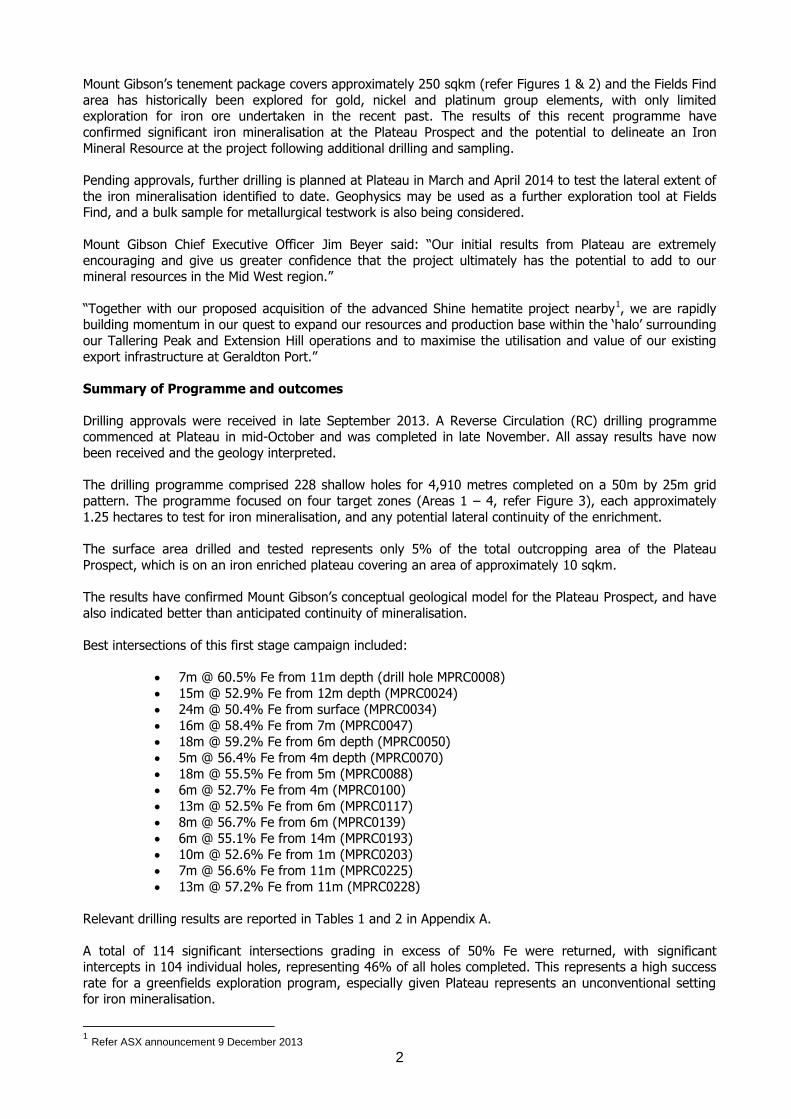
Figure 6: Area 3 showing the location of the drill holes, the distribution of the laterite depth and contour
lines for the iron grades. The black line shows the location of the cross section shown in Figure 7 below.
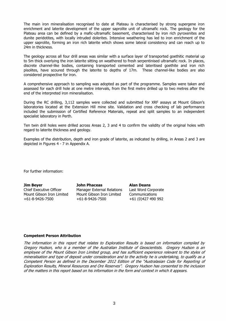
Figure 7: Cross Section C’-C showing the regolith profile for Area 3 and the most significant iron
mineralisation intercepts. Cross section shown with 2-times vertical exaggeration.
8
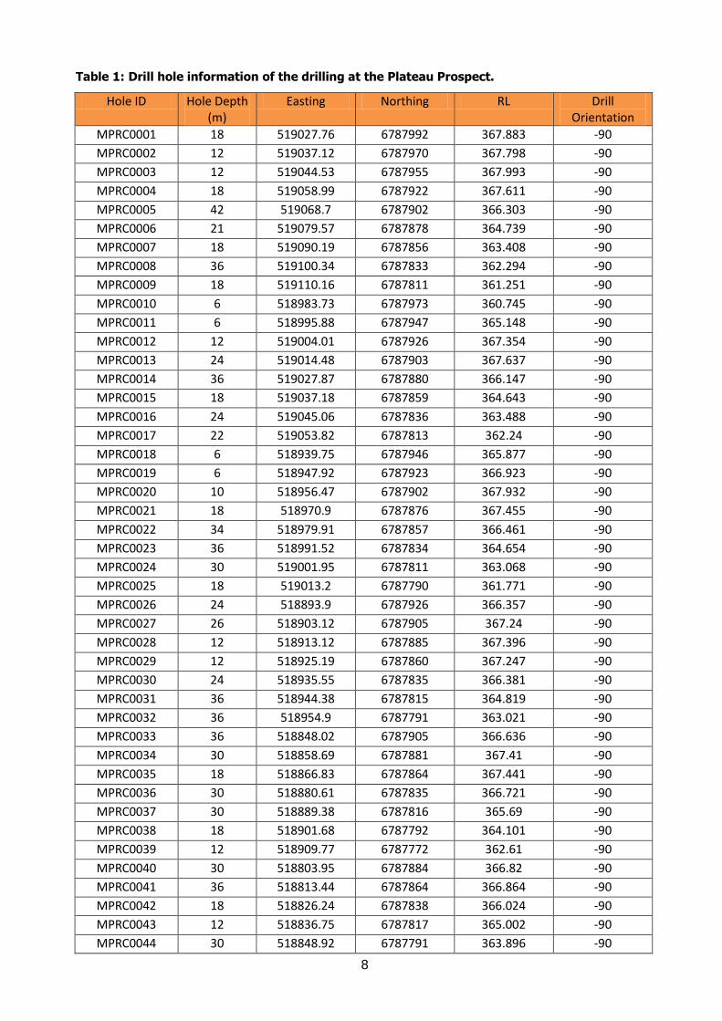
Table 1: Drill hole information of the drilling at the Plateau Prospect.
Hole ID Hole Depth (m)
Easting Northing RL Drill Orientation
MPRC0001 18 519027.76 6787992 367.883 -90
MPRC0002 12 519037.12 6787970 367.798 -90
MPRC0003 12 519044.53 6787955 367.993 -90
MPRC0004 18 519058.99 6787922 367.611 -90
MPRC0005 42 519068.7 6787902 366.303 -90
MPRC0006 21 519079.57 6787878 364.739 -90
MPRC0007 18 519090.19 6787856 363.408 -90
MPRC0008 36 519100.34 6787833 362.294 -90
MPRC0009 18 519110.16 6787811 361.251 -90
MPRC0010 6 518983.73 6787973 360.745 -90
MPRC0011 6 518995.88 6787947 365.148 -90
MPRC0012 12 519004.01 6787926 367.354 -90
MPRC0013 24 519014.48 6787903 367.637 -90
MPRC0014 36 519027.87 6787880 366.147 -90
MPRC0015 18 519037.18 6787859 364.643 -90
MPRC0016 24 519045.06 6787836 363.488 -90
MPRC0017 22 519053.82 6787813 362.24 -90
MPRC0018 6 518939.75 6787946 365.877 -90
MPRC0019 6 518947.92 6787923 366.923 -90
MPRC0020 10 518956.47 6787902 367.932 -90
MPRC0021 18 518970.9 6787876 367.455 -90
MPRC0022 34 518979.91 6787857 366.461 -90
MPRC0023 36 518991.52 6787834 364.654 -90
MPRC0024 30 519001.95 6787811 363.068 -90
MPRC0025 18 519013.2 6787790 361.771 -90
MPRC0026 24 518893.9 6787926 366.357 -90
MPRC0027 26 518903.12 6787905 367.24 -90
MPRC0028 12 518913.12 6787885 367.396 -90
MPRC0029 12 518925.19 6787860 367.247 -90
MPRC0030 24 518935.55 6787835 366.381 -90
MPRC0031 36 518944.38 6787815 364.819 -90
MPRC0032 36 518954.9 6787791 363.021 -90
MPRC0033 36 518848.02 6787905 366.636 -90
MPRC0034 30 518858.69 6787881 367.41 -90
MPRC0035 18 518866.83 6787864 367.441 -90
MPRC0036 30 518880.61 6787835 366.721 -90
MPRC0037 30 518889.38 6787816 365.69 -90
MPRC0038 18 518901.68 6787792 364.101 -90
MPRC0039 12 518909.77 6787772 362.61 -90
MPRC0040 30 518803.95 6787884 366.82 -90
MPRC0041 36 518813.44 6787864 366.864 -90
MPRC0042 18 518826.24 6787838 366.024 -90
MPRC0043 12 518836.75 6787817 365.002 -90
MPRC0044 30 518848.92 6787791 363.896 -90
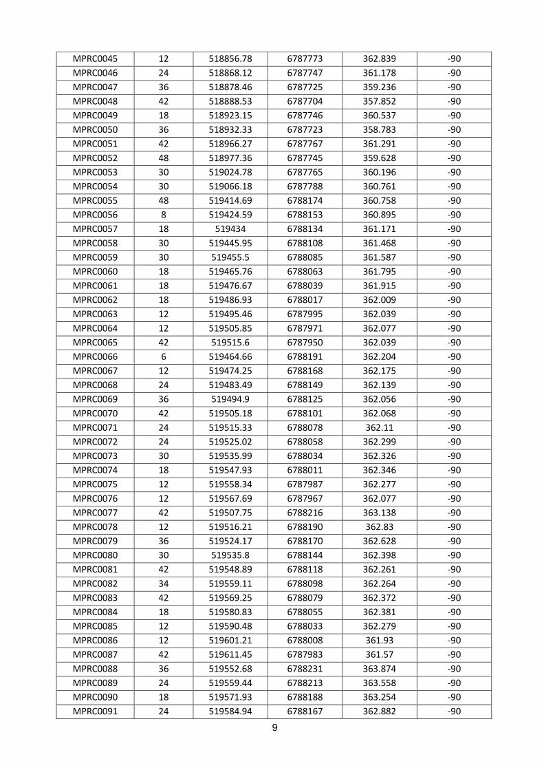
9
MPRC0045 12 518856.78 6787773 362.839 -90
MPRC0046 24 518868.12 6787747 361.178 -90
MPRC0047 36 518878.46 6787725 359.236 -90
MPRC0048 42 518888.53 6787704 357.852 -90
MPRC0049 18 518923.15 6787746 360.537 -90
MPRC0050 36 518932.33 6787723 358.783 -90
MPRC0051 42 518966.27 6787767 361.291 -90
MPRC0052 48 518977.36 6787745 359.628 -90
MPRC0053 30 519024.78 6787765 360.196 -90
MPRC0054 30 519066.18 6787788 360.761 -90
MPRC0055 48 519414.69 6788174 360.758 -90
MPRC0056 8 519424.59 6788153 360.895 -90
MPRC0057 18 519434 6788134 361.171 -90
MPRC0058 30 519445.95 6788108 361.468 -90
MPRC0059 30 519455.5 6788085 361.587 -90
MPRC0060 18 519465.76 6788063 361.795 -90
MPRC0061 18 519476.67 6788039 361.915 -90
MPRC0062 18 519486.93 6788017 362.009 -90
MPRC0063 12 519495.46 6787995 362.039 -90
MPRC0064 12 519505.85 6787971 362.077 -90
MPRC0065 42 519515.6 6787950 362.039 -90
MPRC0066 6 519464.66 6788191 362.204 -90
MPRC0067 12 519474.25 6788168 362.175 -90
MPRC0068 24 519483.49 6788149 362.139 -90
MPRC0069 36 519494.9 6788125 362.056 -90
MPRC0070 42 519505.18 6788101 362.068 -90
MPRC0071 24 519515.33 6788078 362.11 -90
MPRC0072 24 519525.02 6788058 362.299 -90
MPRC0073 30 519535.99 6788034 362.326 -90
MPRC0074 18 519547.93 6788011 362.346 -90
MPRC0075 12 519558.34 6787987 362.277 -90
MPRC0076 12 519567.69 6787967 362.077 -90
MPRC0077 42 519507.75 6788216 363.138 -90
MPRC0078 12 519516.21 6788190 362.83 -90
MPRC0079 36 519524.17 6788170 362.628 -90
MPRC0080 30 519535.8 6788144 362.398 -90
MPRC0081 42 519548.89 6788118 362.261 -90
MPRC0082 34 519559.11 6788098 362.264 -90
MPRC0083 42 519569.25 6788079 362.372 -90
MPRC0084 18 519580.83 6788055 362.381 -90
MPRC0085 12 519590.48 6788033 362.279 -90
MPRC0086 12 519601.21 6788008 361.93 -90
MPRC0087 42 519611.45 6787983 361.57 -90
MPRC0088 36 519552.68 6788231 363.874 -90
MPRC0089 24 519559.44 6788213 363.558 -90
MPRC0090 18 519571.93 6788188 363.254 -90
MPRC0091 24 519584.94 6788167 362.882 -90

10
MPRC0092 24 519596.33 6788144 362.501 -90
MPRC0093 18 519606.66 6788120 362.26 -90
MPRC0094 12 519617.24 6788100 361.973 -90
MPRC0095 24 519628.34 6788076 361.635 -90
MPRC0096 12 519640.93 6788048 361.115 -90
MPRC0097 12 519649.6 6788030 360.655 -90
MPRC0098 12 519659.69 6788008 360.05 -90
MPRC0099 42 519595.52 6788253 364.553 -90
MPRC0100 30 519604.26 6788231 364.193 -90
MPRC0101 12 519614.66 6788210 363.756 -90
MPRC0102 12 519625.18 6788185 363.26 -90
MPRC0103 42 519634.51 6788163 362.669 -90
MPRC0104 24 519645.4 6788142 362.12 -90
MPRC0105 24 519656.28 6788120 361.379 -90
MPRC0106 9 519667.85 6788097 360.646 -90
MPRC0107 9 519676.16 6788078 360.106 -90
MPRC0108 6 519685.42 6788057 359.645 -90
MPRC0109 42 519700.28 6788029 358.784 -90
MPRC0110 42 520071.92 6788478 352.461 -90
MPRC0111 14 520082.31 6788454 351.65 -90
MPRC0112 21 520092.97 6788431 350.992 -90
MPRC0113 20 520102.97 6788410 350.582 -90
MPRC0114 42 520114.15 6788388 350.27 -90
MPRC0115 22 520123.97 6788367 350.056 -90
MPRC0116 18 520133.96 6788342 349.857 -90
MPRC0117 23 520144.63 6788317 349.676 -90
MPRC0118 42 520153.63 6788296 349.965 -90
MPRC0119 14 520116.69 6788498 350.863 -90
MPRC0120 18 520126.56 6788475 350.278 -90
MPRC0121 18 520136.16 6788453 349.764 -90
MPRC0122 24 520146.65 6788432 349.292 -90
MPRC0123 21 520157.69 6788408 348.983 -90
MPRC0124 21 520168.66 6788387 348.896 -90
MPRC0125 21 520180.97 6788362 348.86 -90
MPRC0126 30 520193.29 6788339 348.828 -90
MPRC0127 15 520203.92 6788320 348.897 -90
MPRC0128 18 520165.22 6788517 349.317 -90
MPRC0129 18 520175.42 6788496 348.725 -90
MPRC0130 21 520184.97 6788474 348.245 -90
MPRC0131 18 520195.55 6788450 347.932 -90
MPRC0132 20 520205.93 6788426 347.932 -90
MPRC0133 18 520214.93 6788405 347.964 -90
MPRC0134 12 520225.12 6788381 348.06 -90
MPRC0135 10 520235.97 6788358 348.381 -90
MPRC0136 10 520245.8 6788336 348.78 -90
MPRC0137 42 520209.43 6788539 348.109 -90
MPRC0138 24 520220.43 6788516 347.642 -90

11
MPRC0139 18 520230.81 6788494 347.197 -90
MPRC0140 18 520241.24 6788471 347.057 -90
MPRC0141 42 520253.3 6788445 347.198 -90
MPRC0142 18 520262.49 6788426 347.448 -90
MPRC0143 12 520271.76 6788404 347.829 -90
MPRC0144 11 520283.13 6788379 348.267 -90
MPRC0145 33 520293.58 6788358 348.6 -90
MPRC0146 16 520257.47 6788561 346.92 -90
MPRC0147 20 520267.98 6788538 346.371 -90
MPRC0148 8 520279.15 6788517 346.171 -90
MPRC0149 8 520290.43 6788493 346.405 -90
MPRC0150 8 520299.79 6788472 346.702 -90
MPRC0151 6 520311.14 6788447 347.045 -90
MPRC0152 6 520322.28 6788424 347.287 -90
MPRC0153 6 520332.61 6788401 347.589 -90
MPRC0154 6 520342.99 6788379 347.904 -90
MPRC0155 42 520305.42 6788582 345.77 -90
MPRC0156 10 520313.04 6788564 345.549 -90
MPRC0157 11 520326.14 6788538 345.658 -90
MPRC0158 11 520336.12 6788514 345.9 -90
MPRC0159 8 520343.56 6788496 346.116 -90
MPRC0160 42 520354.54 6788468 346.287 -90
MPRC0161 9 520362.37 6788446 346.549 -90
MPRC0162 6 520370.17 6788422 346.978 -90
MPRC0163 42 520377.66 6788399 347.256 -90
MPRC0164 42 517816.19 6787753 353.564 -90
MPRC0165 18 517823.71 6787735 352.967 -90
MPRC0166 12 517833.98 6787712 352.035 -90
MPRC0167 20 517846.64 6787686 351.159 -90
MPRC0168 12 517860.26 6787658 350.335 -90
MPRC0169 30 517870.09 6787636 349.83 -90
MPRC0170 18 517878.96 6787619 349.318 -90
MPRC0171 12 517891.68 6787594 348.779 -90
MPRC0172 12 517902.67 6787572 348.344 -90
MPRC0173 12 517912.12 6787553 348.034 -90
MPRC0174 30 517923.63 6787530 347.829 -90
MPRC0175 18 517968.59 6787550 347.199 -90
MPRC0176 15 517957.56 6787573 347.58 -90
MPRC0177 18 517947.63 6787595 347.948 -90
MPRC0178 18 517936.89 6787618 348.53 -90
MPRC0179 17 517926.14 6787642 349.149 -90
MPRC0180 18 517913.31 6787668 349.868 -90
MPRC0181 21 517902.1 6787688 350.678 -90
MPRC0182 21 517892.09 6787709 351.397 -90
MPRC0183 21 517882.31 6787729 352.259 -90
MPRC0184 18 517871.6 6787754 353.458 -90
MPRC0185 18 517862.03 6787778 354.35 -90

12
MPRC0186 15 518012.47 6787572 346.543 -90
MPRC0187 18 518003.52 6787594 346.986 -90
MPRC0188 12 517995.29 6787615 347.477 -90
MPRC0189 18 517983.41 6787639 348.013 -90
MPRC0190 30 517972.38 6787662 348.736 -90
MPRC0191 18 517961.91 6787683 349.383 -90
MPRC0192 36 517951.04 6787707 350.389 -90
MPRC0193 24 517940.43 6787730 351.476 -90
MPRC0194 24 517929.74 6787753 352.628 -90
MPRC0195 18 517918.96 6787775 353.649 -90
MPRC0196 30 517909.49 6787795 354.19 -90
MPRC0197 18 518058.39 6787590 346.21 -90
MPRC0198 18 518047.6 6787614 346.476 -90
MPRC0199 18 518037.18 6787638 347.09 -90
MPRC0200 18 518026.92 6787658 347.527 -90
MPRC0201 18 518014.11 6787684 348.341 -90
MPRC0202 18 518001.29 6787707 349.243 -90
MPRC0203 18 517989.98 6787726 350.134 -90
MPRC0204 18 517981.71 6787750 351.206 -90
MPRC0205 12 517973.02 6787773 351.946 -90
MPRC0206 10 517965.67 6787795 352.404 -90
MPRC0207 6 517957.06 6787819 352.607 -90
MPRC0208 30 518105.83 6787612 346.146 -90
MPRC0209 18 518093.95 6787638 346.345 -90
MPRC0210 12 518084.02 6787660 346.676 -90
MPRC0211 13 518073.52 6787683 347.322 -90
MPRC0212 30 518062.05 6787705 348.028 -90
MPRC0213 18 518051.7 6787727 348.768 -90
MPRC0214 12 518040.9 6787750 349.666 -90
MPRC0215 6 518031.32 6787772 350.339 -90
MPRC0216 6 518021.36 6787796 350.991 -90
MPRC0217 9 518010.91 6787817 351.394 -90
MPRC0218 30 518001 6787841 351.375 -90
MPRC0219 18 520146.36 6788436 349.269 -90
MPRC0220 30 520143.5 6788322 349.714 -90
MPRC0221 30 519597.12 6788247 364.389 -90
MPRC0222 24 519644.78 6788146 362.116 -90
MPRC0223 24 519562.24 6788209 363.46 -90
MPRC0224 27 519494.39 6788127 362.084 -90
MPRC0225 30 519101.19 6787829 362.095 -90
MPRC0226 24 518993.84 6787830 364.344 -90
MPRC0227 30 518930.99 6787730 359.336 -90
MPRC0228 26 518877.57 6787729 359.497 -90
13
Table 2: Significant iron ore intercepts at the Plateau Prospect (intercepts above 50%Fe)
Hole ID From (m)
To (m)
Width (m)
Fe (%)
SiO2 (%)
Al2O3 (%)
P (%)
S (%)
TiO2 (%)
LOI (%)
MPRC0005 0 8 8 51.26 6.42 5.50 0.023 0.051 2.99 10.35
MPRC0007 3 6 3 53.84 6.43 4.84 0.019 0.029 2.80 7.86
MPRC0008 11 18 7 60.54 4.01 1.05 0.003 0.014 1.00 5.09
MPRC0014 1 9 8 54.83 4.56 4.90 0.017 0.027 2.47 8.67
MPRC0015 8 9 5 54.81 3.88 5.82 0.016 0.022 3.79 7.37
MPRC0016 2 6 4 51.12 6.28 7.36 0.019 0.029 4.09 8.32
MPRC0017 9 14 5 54.59 9.91 3.27 0.003 0.011 2.21 5.19
MPRC0023 6 7 10 52.00 9.20 4.29 0.007 0.021 1.63 8.45
MPRC0024 1 6 5 51.58 5.07 5.50 0.015 0.033 5.20 8.60
MPRC0024 12 27 15 52.92 7.89 4.24 0.004 0.035 1.17 8.35
MPRC0025 10 12 2 51.60 13.43 2.81 0.004 0.009 1.83 6.77
MPRC0032 0 3 3 52.10 4.80 5.87 0.019 0.052 3.49 10.03
MPRC0032 6 21 15 52.13 7.21 4.70 0.005 0.017 1.67 9.85
MPRC0033 1 8 7 51.77 7.08 4.12 0.020 0.044 3.00 10.73
MPRC0034 0 24 24 50.43 8.58 6.83 0.013 0.088 2.33 8.63
MPRC0035 0 9 9 52.05 6.62 5.89 0.023 0.037 3.62 8.66
MPRC0040 0 9 9 54.02 5.82 3.96 0.028 0.061 4.03 8.14
MPRC0041 1 3 2 52.63 4.89 4.84 0.028 0.047 3.80 10.38
MPRC0046 1 15 14 54.20 11.12 3.63 0.006 0.027 1.47 5.21
MPRC0047 7 23 16 58.41 6.37 1.43 0.002 0.015 0.97 4.76
MPRC0049 1 4 3 53.54 5.72 5.22 0.015 0.036 2.19 8.77
MPRC0050 6 24 18 59.20 7.14 1.70 0.002 0.017 0.90 4.51
MPRC0051 0 6 6 53.07 4.97 4.39 0.020 0.033 7.31 6.38
MPRC0051 9 17 8 54.49 7.77 2.84 0.006 0.017 1.52 7.65
MPRC0053 8 10 2 50.63 12.94 3.62 0.006 0.023 1.53 7.82
MPRC0054 19 21 2 54.16 10.23 2.70 0.003 0.005 2.69 3.39
MPRC0058 1 5 4 50.03 7.06 6.44 0.033 0.056 1.64 12.23
MPRC0059 0 2 2 51.17 8.65 7.12 0.023 0.045 2.32 7.75
MPRC0068 1 4 3 57.02 4.55 5.70 0.011 0.023 1.24 7.86
MPRC0069 4 11 7 52.78 3.81 6.97 0.021 0.032 1.82 10.55
MPRC0070 4 9 5 56.35 3.52 4.50 0.023 0.022 4.17 5.33
MPRC0077 2 6 4 52.31 7.92 5.02 0.013 0.026 0.69 9.83
MPRC0077 11 14 3 54.04 5.64 2.11 0.003 0.017 0.31 9.51
MPRC0079 2 5 3 55.74 6.41 5.15 0.011 0.030 1.30 6.82
MPRC0080 5 7 2 55.87 3.73 5.39 0.021 0.030 2.39 7.33
MPRC0081 4 6 2 54.29 3.82 7.34 0.018 0.035 3.53 5.29
MPRC0088 5 23 18 55.50 3.86 4.27 0.012 0.039 1.43 8.88
MPRC0089 3 7 4 53.83 5.76 6.04 0.017 0.026 1.48 8.32
MPRC0089 13 17 4 52.69 9.80 2.49 0.003 0.010 0.85 7.51
MPRC0090 8 12 4 51.54 12.17 3.10 0.002 0.009 1.19 6.04
MPRC0091 3 8 5 52.68 4.54 5.93 0.025 0.024 4.09 8.59
MPRC0092 5 7 2 54.07 6.61 7.03 0.015 0.021 3.21 4.09
MPRC0099 2 11 9 51.04 6.84 6.47 0.020 0.035 2.15 10.65
MPRC0099 15 19 4 54.07 7.12 2.89 0.014 0.048 0.28 10.99

14
MPRC0099 24 26 2 55.52 7.89 2.18 0.003 0.009 0.23 5.68
MPRC0100 4 10 6 52.67 8.58 5.98 0.016 0.024 2.05 6.98
MPRC0101 7 9 2 51.31 12.23 4.62 0.005 0.010 0.83 7.95
MPRC0109 2 4 2 50.92 6.33 6.11 0.021 0.049 0.89 11.37
MPRC0110 12 15 3 56.35 7.60 2.85 0.002 0.008 0.37 4.96
MPRC0111 3 10 7 50.30 7.22 6.67 0.017 0.030 0.90 10.19
MPRC0112 6 12 6 50.90 6.11 5.91 0.012 0.029 0.43 11.64
MPRC0113 6 11 5 53.62 4.66 4.60 0.010 0.021 0.29 11.53
MPRC0114 16 18 2 53.84 7.59 3.14 0.003 0.008 0.36 8.16
MPRC0115 7 16 9 50.82 7.73 5.91 0.011 0.024 0.56 10.46
MPRC0116 6 9 3 54.02 2.92 4.54 0.022 0.034 0.73 12.00
MPRC0117 6 19 13 52.45 6.77 6.04 0.021 0.018 1.28 7.96
MPRC0118 6 10 4 52.61 7.35 6.76 0.017 0.023 1.32 7.11
MPRC0121 6 11 5 52.34 6.56 4.82 0.012 0.024 0.31 11.45
MPRC0122 8 11 3 51.89 5.72 5.04 0.013 0.019 0.38 11.89
MPRC0123 6 9 3 52.12 5.25 5.39 0.018 0.017 0.37 11.92
MPRC0124 6 10 4 52.89 3.69 5.94 0.020 0.044 1.02 10.91
MPRC0124 13 16 3 50.03 12.94 3.02 0.010 0.016 0.22 9.05
MPRC0126 1 9 8 51.43 5.51 6.68 0.021 0.033 1.01 11.34
MPRC0130 6 8 2 52.56 4.58 6.40 0.018 0.021 1.50 8.61
MPRC0131 6 9 3 52.24 4.46 6.11 0.017 0.027 0.94 10.61
MPRC0132 5 13 8 54.85 5.52 5.12 0.018 0.023 1.26 7.63
MPRC0133 4 10 6 52.08 6.49 6.70 0.016 0.019 1.40 9.60
MPRC0134 3 8 5 52.05 6.50 7.17 0.017 0.027 1.77 8.53
MPRC0136 1 3 2 50.87 7.60 10.02 0.013 0.025 1.80 5.83
MPRC0139 6 14 8 56.68 4.81 4.46 0.015 0.022 1.07 6.56
MPRC0140 6 10 4 53.36 5.06 5.90 0.017 0.021 1.12 10.08
MPRC0141 4 7 3 51.31 4.69 7.83 0.019 0.029 1.62 10.45
MPRC0142 2 4 2 53.78 5.17 6.86 0.014 0.028 1.50 8.03
MPRC0142 7 9 2 54.04 7.90 2.94 0.012 0.035 0.21 10.67
MPRC0146 4 6 2 50.71 5.45 7.28 0.018 0.035 0.35 12.52
MPRC0147 5 11 6 54.84 6.95 5.59 0.019 0.019 1.38 5.54
MPRC0155 5 7 2 51.56 7.27 7.57 0.017 0.021 1.28 7.85
MPRC0167 4 7 3 54.83 3.48 6.79 0.015 0.016 5.58 4.61
MPRC0168 5 8 3 52.47 4.92 6.49 0.022 0.025 3.37 8.35
MPRC0180 4 7 3 52.13 5.02 6.63 0.017 0.025 2.45 8.81
MPRC0180 13 17 4 51.06 7.53 2.63 0.007 0.025 0.61 10.84
MPRC0181 11 16 5 50.09 7.82 4.48 0.005 0.018 0.45 11.81
MPRC0182 12 15 3 53.75 8.21 4.59 0.005 0.009 1.64 6.58
MPRC0183 2 4 2 51.21 3.35 5.41 0.023 0.042 5.90 10.59
MPRC0184 4 8 4 52.42 8.09 6.06 0.010 0.037 1.63 7.71
MPRC0186 7 9 2 50.83 5.14 7.46 0.017 0.024 0.32 12.50
MPRC0190 2 4 2 51.62 8.52 8.35 0.018 0.024 2.42 5.26
MPRC0192 3 5 2 52.51 4.92 4.83 0.027 0.036 3.24 10.93
MPRC0192 16 19 3 55.57 7.42 3.31 0.003 0.012 1.52 6.71
MPRC0193 4 10 6 52.40 4.90 6.35 0.011 0.018 2.12 10.16
MPRC0193 14 20 6 55.14 7.86 3.15 0.011 0.014 1.30 7.37

15
MPRC0194 0 5 5 50.44 6.84 7.63 0.014 0.037 1.98 10.57
MPRC0195 14 20 6 52.41 6.41 4.61 0.022 0.026 1.07 10.66
MPRC0196 3 9 6 50.61 11.38 5.03 0.003 0.013 0.57 9.25
MPRC0199 7 10 3 52.64 5.86 7.11 0.010 0.020 0.97 8.85
MPRC0200 7 9 2 50.13 5.68 8.15 0.014 0.017 1.23 11.25
MPRC0202 2 7 5 51.26 5.83 6.32 0.016 0.032 1.21 12.07
MPRC0203 1 11 10 52.58 8.51 4.21 0.095 0.018 1.12 9.52
MPRC0203 14 16 2 51.54 15.56 2.16 0.015 0.008 0.86 6.06
MPRC0204 2 8 6 52.87 8.60 3.24 0.011 0.045 0.70 10.43
MPRC0211 6 10 4 50.97 6.77 8.87 0.011 0.020 1.35 8.58
MPRC0212 3 10 7 50.02 8.84 7.10 0.012 0.020 0.87 10.00
MPRC0219 7 9 2 50.82 4.80 6.58 0.019 0.038 0.48 12.51
MPRC0220 6 12 6 51.32 6.80 6.81 0.020 0.026 1.71 8.06
MPRC0221 3 9 6 52.10 7.60 5.12 0.020 0.038 2.04 9.14
MPRC0221 16 20 4 51.05 11.54 3.56 0.018 0.029 0.62 9.10
MPRC0223 3 7 4 51.15 8.26 5.57 0.015 0.025 1.53 9.32
MPRC0224 4 10 6 52.01 4.94 6.63 0.022 0.030 1.80 10.47
MPRC0225 11 18 7 56.63 5.25 1.32 0.003 0.016 0.83 7.18
MPRC0225 23 27 4 55.74 6.08 3.25 0.003 0.016 1.18 7.03
MPRC0226 3 7 4 52.77 7.14 6.20 0.011 0.026 2.49 7.65
MPRC0226 12 18 6 53.77 8.06 3.04 0.005 0.032 1.12 7.53
MPRC0227 8 16 8 56.00 10.43 2.35 0.002 0.012 0.97 4.83
MPRC0227 21 24 3 53.16 13.04 1.84 0.002 0.005 1.38 4.68
MPRC0228 11 24 13 57.24 7.93 2.61 0.003 0.019 1.39 4.31
Significant intercepts have been calculated using >50.0% Fe as the minimum grade cut-off with a minimum width of
2m and incorporating up to 2m of consecutive internal dilution <50.0% Fe. The minimum Fe grade for the commencement and termination of the intercept calculation was >50.0% Fe.

16
APPENDIX B – Table 1 information in accordance with JORC 2012: Plateau Prospect,
Fields Find Project
Section 1 Sampling Techniques and Data
(Criteria in this section apply to all succeeding sections.)
Criteria Commentary
Sampling techniques
All data collected from the Plateau Prospect has been based on a comprehensive Reverse Circulation (“RC”) drilling program completed in a period of 20 days
during October and November 2013.
Samples were acquired at one metre intervals through a static cone splitter
attached to the RC drill rig. Two samples were taken for each metre at the time
of drilling, and each sample identified with a sample ID with suffix “A” or “B”.
Samples logged as prospective for iron mineralisation were prioritised and
assayed first.
Drilling techniques
228 RC drill holes have been completed at the Plateau Prospect using a face
sampling hammer with a 108 mm bit size. All holes were drilled in a vertical
orientation.
Drill sample recovery
The geologist recorded the sample recovery during the drilling program and
these were overall very good.
Minor sample loss was recognised while sampling the first metre of some drill holes due to very fine grain size of the surface and near-surface material.
No relationship between sample recovery and grade has been recognised.
Logging
All drill holes have been geologically logged for lithology, texture, alteration and
mineralisation. All samples were logged in the field with spoil piles and sieved
chipped assessed.
The total length of drilling at the Plateau is 4,910m, including 263m of twin
holes.
Sub-sampling techniques and sample preparation
Samples are received by the lab, sorted and duplicate samples are weighed and recorded. Samples are typically 2 to 4kg, and usually submitted in batches of 80
to 200 samples.
Each sample is reduced by riffle splitting to approximately a 400g sub-sample.
They are then re-bagged and the residue returned to the original bag. The sub-samples are put in the preparation oven to dry for 4 hours in temperatures of
100°C to 110°C. Sub-samples are then pulverized until 90% passing 106µm
fraction.
An aliquot of 0.7g to 3g of the sub-sample is then submitted to 3 step LOI
analysis using a TGA system.
Between 30g to 90g of the sub-sample is extracted as an aliquot and submitted
to a MAGNASAT magnetic susceptibility test (which does not affect or alter the
material). This aliquot is then placed again in the oven to dry for another hour.
The remainder (redsidue) of the subsample is stored as a pulp in a labelled
paper satchel.
0.7g of the sub-sample is submitted for fusion with 7 grams of flux to form an
analysis bead and analysed using the an XRF.
Sample quality control analysis is then conducted on each sample and on the batch.

17
Criteria Commentary
Results are reported to the client in csv format.
Quality of assay data and laboratory tests
Mount Gibson followed its established QAQC procedures for this exploration
programme with the use of Certified Reference Materials as standards, along with field and laboratory duplicates
Iron ore standards (Certified Reference Materials) in pulp and course form have been submitted at a rate of one for every 30 samples.
For the analysis of 2,063 samples, 134 standards were assayed. The acceptable
limits for against the expected values of the CRM’s is 3 standard deviations, however the accuracy of the reported values against expected values fell within
±2 standard variation for all Fe values, except for sample 01190A which fell within ±3 standard deviations.
79 Field duplicates were taken and submitted during the programme. The field duplicate samples taken presented an excellent duplicability in terms of accurate
values, with Fe showing an R2 of 0.98, SiO2 an R2 of 0.96 and Al2O3 an R2 of 0.99.
The laboratory used for the programme conducted 104 Lab Duplicate checks and 103
Lab Standards which all were within acceptable limits.
Verification of sampling and assaying
Validation and cross checking of lab performance has included the submission of repeat and split samples to Bureau Veritas laboratories in Perth, and Spectrolab
at Geraldton.
Ten twin drill holes were drilled with collar locations within 4 metres of the parent collar to understand the lateral variation of the laterite profile and Fe
grades.
Assay results are provided by the lab to Mt Gibson in csv format, and then
validated and entered into the Mt Gibson database situated at the head office. Backups of the database are stored out of office.
Assay, sample ID and logging data are matched and validated using filters the
Mt Gibson drill database. The data is further visually validated by Mount Gibson geologists and database staff.
Significant intercepts are generated from the database by Mount Gibson geologists, then verified and peer reviewed by Mt Gibson principal Geologists.
Location of data points
A hand held GPS (Garmin GPSmap76 model) was used to determine the drill
hole collars during the drill program with a ±8m coordinate accuracy. A DGPS survey of all drill hole collars was conducted at Plateau Prospect on 4 & 5
December 2013 at the completion of the program, along with a topographic survey. The final survey used a Trimble RTK GPS system with expected accuracy
of +/- 0.02m horizontal and +/- 0.03m vertical, relative to each other and to the
onsite survey control.
No downhole surveys were conducted due the vertical orientation and short
length of the drill holes.
Data spacing and distribution
Drillholes were completed approximately every 25m along 50m spaced drill lines, oriented 340° true north. While preliminary, it appears that 50m spacing is
adequate to understand geological continuity, however further assessment is required to determine the spacing confidence with regards to grade continuity.
Ten twin holes were collared within 4m of original collars. All holes were drilled
vertically with samples taken to assess for iron taken at 1m intervals.

18
Criteria Commentary
Orientation of data in relation to geological structure
The iron mineralisation is based on the supergene iron enrichment of the
regolith, characterised by large near horizontal laterite development. Occasionally the iron mineralisation goes into the saprolite/laterite interface,
mostly when the saprolite is product of weathered dolerite. Vertical drilling is the
most appropriate orientation for the geology.
Sample security
All samples taken from the Plateau Prospect were kept within Mount Gibson Iron
premises and analysed by Spectrolab at Mount Gibson Mining’s Extension Hill
laboratory. Round robin samples were couriered or transported by contract staff to Bureau Veritas Perth or Spectrolab Geraldton.
Sample security was not considered a significant risk to the project. No specific measures were taken by Mount Gibson to ensure sample security beyond the
normal chain of custody for a sample submission.
Audits or reviews
A field visit at the drilling site was conducted by John Libby (Consulting Geologist from DIGIROCK) in November to review the quality and reliability of
the data acquisition.
Section 2 Reporting of Exploration Results
(Criteria listed in section 1, and where relevant, in sections 3 and 4, also apply to this section.)
Criteria Commentary
Mineral tenement and land tenure status
Plateau Prospect is located on the Exploration Licence E59/1268-I held by Mt
Gibson Mining Ltd, a fully owned subsidiary of Mt Gibson Iron Ltd. Mt Gibson
Mining acquired the Exploration licence through a sale process in April 2013.
Exploration done by other parties
The ground has historically been explored for gold, nickel and platinum group elements. In 2006 a small iron ore exploration programme was conducted by
Royal Resources Limited. Historical exploration results have not been considered for this report as the exploration executed was targeting mostly
nickel mineralisation with very few samples assayed for iron. Those historical
drillholes assayed for iron are very small in number (~12 holes) relative to this drill program (228 drillholes).
Geology
The geology for the Plateau area can be defined by a mafic-ultramafic
basement, characterised by iron rich pyroxenites and dunite peridotites, with locally intruded dolerites.
These rocks have been exposed to intensive weathering and the iron enrichment of the upper saprolite, forming the laterite which shows some
lateral consistency and can reach up to 24m in thickness.
In places transported material loosely consolidated overlies the laterites. The
depth of the transported material is not clearly defined and locally can
include pisolitic material, possibly identifying the location of paleochannels.
The main iron mineralisation recognised so far is characterised by strong
supergene iron enrichment and laterite development of the upper saprolite of ultramafic rocks.

19
Criteria Commentary
Drill hole Information
228 drill holes have been completed at the Plateau Prospect throughout four
main areas. The drilling program was conducted in October and November 2013. All drillholes were drilled vertically.
Relevant drill hole information has been tabled in Appendix A including hole ID, drill
hole depth, drill collar location and elevation, and significant intercepts.
Significant intercepts have been calculated using >50.0% Fe as the minimum
grade cut-off with a minimum width of 2m and incorporating up to 2m of consecutive internal dilution <50.0% Fe. The minimum Fe grade for the
commencement and termination of the intercept calculation was >50.0% Fe.
Data aggregation methods
All samples have been collected at 1m intervals downhole. Significant intercepts have been analysed using the following criteria:
>50.0% Fe as the minimum grade cut-off with a minimum width of 2m and incorporating up to 2m of consecutive internal dilution <50.0% Fe. The minimum
Fe grade for the commencement and termination of the intercept calculation was
>50.0% Fe.
Relationship between mineralisation widths and intercept lengths
No clear correlation between laterite thickness and Fe grades above 50% was identified.
All drilling is vertical and mineralisation is interpreted as sub-horizontal, therefore intercept lengths should best reflect width of mineralisation. Twin
holes support this interpretation.
Diagrams
Maps and sections in Appendix A show the location of the project and
prospect, and the areas of drilling (refer Figures 1 - 7).
Cross sections and maps of the drill areas in Appendix A show the current
interpretation of the iron mineralised areas, the laterite and pisolite thickness. (Figures 4 - 7)
Balanced reporting
Current understanding is based on a single phase of drilling conducted by
Mount Gibson combined with historical mapping conducted by previous owners of the tenement. While results are encouraging Mount Gibson wishes
to conduct further exploration and test work to gain an improved understanding of the economic potential of the Plateau Prospect.
Other substantive exploration data
No further exploration data has been collected at this stage. Aerial photos, mapping and regional geophysics acquired from the previous owners of the
tenement have been used to define the Plateau Prospect area.
Further work Further drilling is planned for March and April 2014 to test the lateral extents of iron mineralisation. Geophysics and bulk samples are also being
considered.