initial study mitigated negative declaration fort … mnd 1-21-04.pdf · 7140 bodega avenue ... the...
TRANSCRIPT

DRAFT
INITIAL STUDY MITIGATED NEGATIVE DECLARATION
FORT ROSS STATE HISTORIC PARK WATER SUPPLY SYSTEM IMPROVEMENTS PROJECT
January 2004
State of California DEPARTMENT OF PARKS AND RECREATION
Northern Service Center One Capitol Mall – Suite 500 Sacramento, California 95814


•
•
•
•
•
•
MITIGATED NEGATIVE DECLARATION
PROJECT: WATER SUPPLY SYSTEM PROJECT LEAD AGENCY: California Department of Parks and Recreation AVAILABILITY OF DOCUMENTS: The Initial Study for this Mitigated Negative Declaration is available for review at:
Northern Service Center California Department of Parks & Recreation
One Capitol Mall - Suite 410 Sacramento, CA 95814
North Bay District Headquarters
California Department of Parks & Recreation 25381 Steelhead Blvd. Duncan Mills, California 95430
Fort Ross State Historic Park 19005 Coast Highway 1 Jenner, California 95450
Guerneville Regional Library
14107 Armstrong Woods Rd. Guerneville, California 95446 Sebastopol Regional Library 7140 Bodega Avenue Sebastopol, California 95472 California State Parks Internet Website http://www.parks.ca.gov/default.asp?page_id=981
PROJECT DESCRIPTION: The Department of Parks and Recreation proposes to make the improvements described herein to the water supply system at Fort Ross State Historic Park. The following is a summary of the proposed work:
• Replace and modify the existing water treatment facilities to comply with current standards and operational needs.
• Develop additional finished water storage capacity • Add automatic chemical treatment to the Fort Ross Creek well to retard iron bacteria
biofilm growth and maintain well production • Rehabilitate the water supply line support structure at the Fort Ross Creek crossing.
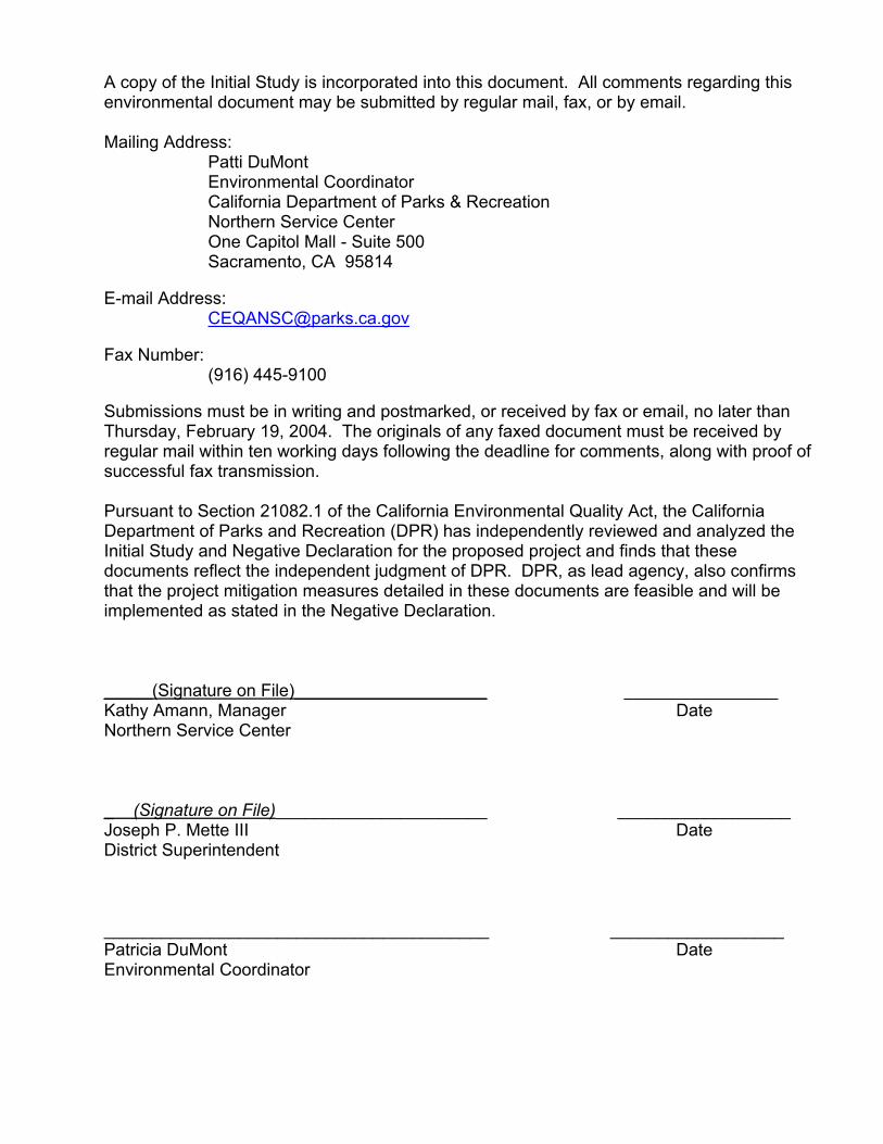
A copy of the Initial Study is incorporated into this document. All comments regarding this environmental document may be submitted by regular mail, fax, or by email. Mailing Address: Patti DuMont Environmental Coordinator California Department of Parks & Recreation Northern Service Center One Capitol Mall - Suite 500 Sacramento, CA 95814 E-mail Address: [email protected] Fax Number: (916) 445-9100 Submissions must be in writing and postmarked, or received by fax or email, no later than Thursday, February 19, 2004. The originals of any faxed document must be received by regular mail within ten working days following the deadline for comments, along with proof of successful fax transmission. Pursuant to Section 21082.1 of the California Environmental Quality Act, the California Department of Parks and Recreation (DPR) has independently reviewed and analyzed the Initial Study and Negative Declaration for the proposed project and finds that these documents reflect the independent judgment of DPR. DPR, as lead agency, also confirms that the project mitigation measures detailed in these documents are feasible and will be implemented as stated in the Negative Declaration. _____(Signature on File)____________________ ________________ Kathy Amann, Manager Date Northern Service Center _ (Signature on File)______________________ __________________ Joseph P. Mette III Date District Superintendent ________________________________________ __________________ Patricia DuMont Date Environmental Coordinator

TABLE of CONTENTS
Chapter/Section Page 1 INTRODUCTION………………………………………………………………... 3 2 PROJECT DESCRIPTION……………………………………………………….. 7 3 ENVIRONMENTAL CHECKLIST………………………………………………..... 13 I. Aesthetics……………………………………………………………17 II. Agricultural Resources……………………………………………..19 III. Air Quality……………………………………………………….……21 IV. Biological Resources………………………………………………. 25 V. Cultural Resources………………………………………………….35 VI. Geology and Soils………………………………………………….. 41 VII. Hazards and Hazardous Materials……………………………….. 49 VIII. Hydrology and Water Quality……………………………………… 53 IX. Land Use and Planning……………………………………………. 59 X. Mineral Resources…………………………………………………. 61 XI. Noise………………………………………………………………… 63 XII. Population and Housing…………………………………………… 65 XIII. Public Services……………………………………………………... 67 XIV. Recreation…………………………………………………………… 69 XV. Transportation/Traffic………………………………………………. 71 XVI. Utilities and Service Systems………………………………………75 4 MANDATORY FINDINGS OF SIGNIFICANCE.................................................….. 77 5 SUMMARY OF MITIGATION MEASURES……………………………………….…. 79 6 REFERENCES…………………………………………………………………..… 85 7 REPORT PREPARATION............................................................................…. 91 Appendices A MAPS, TABLES, AND CHARTS
B PROJECT DESIGN GRAPHICS
C ACRONYMS

THIS PAGE LEFT INTENTIONALLY BLANK

Water Supply System Improvements Fort Ross State Historic Park California Department of Parks & Recreation
3
CHAPTER 1 INTRODUCTION
1.1 INTRODUCTION AND REGULATORY GUIDANCE The Initial Study/Mitigated Negative Declaration (IS/MND) has been prepared by the California Department of Parks and Recreation (DPR) to evaluate the potential environmental effects of the proposed Water Supply System Project at Fort Ross State Historic Park, Sonoma County, California. This document has been prepared in accordance with the California Environmental Quality Act (CEQA), Public Resources Code §21000 et seq., and the State CEQA Guidelines, California Code of Regulations (CCR) §15000 et seq. An Initial Study is conducted by a lead agency to determine if a project may have a significant effect on the environment [CEQA Guidelines §15063(a)]. If there is substantial evidence that a project may have a significant effect on the environment, an Environmental Impact Report (EIR) must be prepared, in accordance with CEQA Guidelines §15064(a). However, if the lead agency determines that revisions in the project plans or proposals made by or agreed to by the applicant mitigate the potentially significant effects to a less-than-significant level, a Mitigated Negative Declaration may be prepared instead of an EIR [CEQA Guidelines §15070(b)]. The lead agency prepares a written statement describing the reasons a proposed project would not have a significant effect on the environment and, therefore, why an EIR need not be prepared. This IS/MND conforms to the content requirements under CEQA Guidelines §15071. 1.2 LEAD AGENCY The lead agency is the public agency with primary approval authority over the proposed project. In accordance with CEQA Guidelines §15051(b)(1), "the lead agency will normally be an agency with general governmental powers, such as a city or county, rather than an agency with a single or limited purpose." The lead agency for the proposed project is DPR. The contact person for the lead agency is: Jim Trapani Senior Landscape Architect California Department of Parks and Recreation Northern Service Center One Capitol Mall, Suite 500 Sacramento, California, 95814 916-445-8769 All comments regarding this environmental document may be submitted by regular mail, fax, or by email.

Water Supply System Improvements Fort Ross State Historic Park California Department of Parks & Recreation
4
Mailing Address: Patti DuMont – Environmental Coordinator California Department of Parks and Recreation Northern Service Center One Capitol Mall, Suite 500 Sacramento, California 95814 E-mail Address: [email protected] Fax Number: (916) 445-9100 Submissions must be postmarked, or received by fax or email, no later than Thursday, February 19, 2004. The originals of any faxed document must be received by regular mail within ten working days following the deadline for comments along with proof of successful fax transmission. 1.3 COMMENTING EFFECTIVELY ON AN ENVIRONMENTAL DOCUMENT Public participation is an essential part of the CEQA process. Review of environmental documents offer interested governmental agencies, private individuals, and organizations an opportunity to consider a proposed project and share expertise; evaluate agency analyses; check for completeness and accuracy; identify areas of concern; and present alternative or additional options for consideration. (California Code of Regulations §15200). To comment effectively on an environmental document, consider the following points: 1. Objectively evaluate the project
•
•
•
•
Consider the activities proposed as part of the project and determine if these actions will result in an impact or change to the environment. If an impact will occur, will it be substantial or "significant"? Significance is determined by the amount of difference between what currently exists and what will exist during or following completion of the project.
If you conclude there would be a significant adverse effect, does the document agree with that assessment? If the impact is potentially significant, are there mitigations (ways to reduce the severity of the impact) included in the document? Will they reduce the impact to a less than significant level? (For an MND, mitigations must reduce all potentially significant impacts to a less than significant level. For an EIR, impacts must be reduced to the extent feasible. All mitigations must be feasible and enforceable.)
• If a potential significant impact has not, in the reviewer's opinion, been adequately identified; if no mitigation has been proposed for a potentially significant impact; or if the mitigation proposed does not appear to be sufficient or appropriate, the

Water Supply System Improvements Fort Ross State Historic Park California Department of Parks & Recreation
5
• • •
•
reviewer should: Identify the specific impact in question; Explain why you believe the impact would occur; Explain why you believe the effect would be significant (§15204[b]); and, if applicable, Explain what additional mitigation measure(s) or changes in proposed mitigations you would recommend.
2. Explain the basis for the comments and recommendations (facts, reasonable
assumptions based on facts, or expert opinion supported by facts) and, whenever possible, submit specific data and/or references supporting your conclusions. (§15204[d])
3. Make sure comments are submitted before the deadline. Comments postmarked
after the close of the public review period will not be accepted. If necessary, fax your comments on or before the close of the review period and follow up by regular mail. Comments must be submitted in writing and must include your name and a valid address. Email addresses are not sufficient.
4. Reviewing agencies or organizations should include the name of a contact person,
who would be available for questions or consultation, along with their comments. (§15204[c]).
1.4 PURPOSE AND DOCUMENT ORGANIZATION The purpose of this document is to evaluate the potential environmental effects of the proposed Water Supply System Project at Fort Ross State Historic Park. Mitigation measures have also been incorporated into the project to eliminate any potentially significant impacts or reduce them to a less-than-significant level. This document is organized as follows: • Chapter 1 - Introduction. This chapter provides an introduction to the project and describes the purpose and
organization of this document. • Chapter 2 - Project Description. This chapter describes the reasons for the project, scope of the project, and project
objectives. • Chapter 3 - Environmental Setting, Impacts, and Mitigation Measures. This chapter identifies the significance of potential environmental impacts, explains
the environmental setting for each environmental issue, and evaluates the potential impacts identified in the CEQA Environmental (Initial Study) Checklist. Mitigation
Water Supply System Improvements Fort Ross State Historic Park California Department of Parks & Recreation
6
measures are incorporated, where appropriate, to reduce potentially significant impacts to a less-than-significant level.
• Chapter 4 - Mandatory Findings of Significance This chapter identifies and summarizes the overall significance of any potential
impacts to natural and cultural resources, cumulative impacts, and impact to humans, as identified in the Initial Study.
• Chapter 5 - Summary of Mitigation Measures. This chapter summarizes the mitigation measures incorporated into the project as a
result of the Initial Study. • Chapter 6 - References. This chapter identifies the references and sources used in the preparation of this
IS/MND. • Chapter 7 - Report Preparation This chapter provides a list of those involved in the preparation of this document. 1.5 SUMMARY OF FINDINGS Chapter 3 of this document contains the Environmental (Initial Study) Checklist that identifies the potential environmental impacts (by environmental issue) and a brief discussion of each impact resulting from implementation of the proposed project. Based on the IS and supporting environmental analysis provided in this document, the proposed Water Supply System Improvments Project would result in less-than-significant impacts for the following issues: aesthetics, agricultural resources, air quality, biological resources, cultural resources, geology and soils, hazards and hazardous materials, hydrology and water quality, land use and planning, mineral resources, noise, population and housing, public services, recreation, transportation/traffic, and utilities and service systems. In accordance with §15064(f) of the CEQA Guidelines, a MND shall be prepared if the proposed project will not have a significant effect on the environment after the inclusion of mitigation measures in the project. Based on the available project information and the environmental analysis presented in this document, there is no substantial evidence that, after the incorporation of mitigation measures, the proposed project would have a significant effect on the environment. It is proposed that a Mitigated Negative Declaration be adopted in accordance with the CEQA Guidelines.

Water Supply System Improvements Fort Ross State Historic Park California Department of Parks & Recreation
7
CHAPTER 2 PROJECT DESCRIPTION
2.1 INTRODUCTION This Initial Study/Mitigated Negative Declaration (IS/MND) has been prepared by the California Department of Parks and Recreation (DPR) to evaluate the potential environmental effects of the proposed Water Supply System Improvements Project at Fort Ross State Historic Park (SHP) in Sonoma County, California. The proposed project would provide a reliable and safe water supply system for Fort Ross SHP. 2.2 PROJECT LOCATION Fort Ross SHP became one of the first units in the State Park system in March 1906. The Park is located on a scenic bluff of the Sonoma coast, approximately 11 miles northwest of the town of Jenner on Highway 1 and is about a two-hour drive from San Francisco. The park unit is composed of 3,517 acres, 4.23 miles of coastline, and a 90-acre underwater park. The Russian fort compound, consisting of the stockade, two blockhouses, a Russian Chapel, the Rotchev House, and a Russian well are the major visitor attractions of the park today. These structures have been either restored or completely reconstructed since the Russian occupation during 1812-1841. Approximately 15 buildings of the American Period, constructed in the late nineteenth and early twentieth centuries, still stand in the areas immediately west of the fort. The project site is located approximately a third of a mile from the Russian fort compound behind a grove of trees near the existing water treatment building, well, evaporation pond and storage tanks. 2.3 BACKGROUND AND NEED FOR THE PROJECT A Draft Emergency Water Supply Evaluation and Assessment was prepared by Richard Slade & Associates in October 1998 to address the immediate water supply needs of Fort Ross. A subsequent July 1999 study developed by Slade & Associates, and a companion report by Brelje & Race Consulting Engineers, looked at the long-term needs of Fort Ross. This study considered technical hydrogeology and potential supply source factors, and identified a number of alternatives to be evaluated and their cost parameters. DPR used the Slade report to guide water exploration efforts completed to date; all alternatives identified in the report have been exhausted. The current water supply for the park consists of a single well – The “Fort Ross Creek Well”, a water treatment plant, and water storage tanks. The storage tanks currently have a total capacity of approximately 128,000 gallons. Water use varies considerably throughout the year. Water usage information from 1990 through 1998 shows an average monthly consumption ranges from 47,000 gallons in December to 119,000 gallons in July. Average annual totals range from a low 778,000 gallons to a high of 1,193,000 gallons. Peak values usually occur in July, and the highest peak is in the range of 150,000. The average annual rate of consumption over the nine-year period was approximately 997,000 gallons.

Water Supply System Improvements Fort Ross State Historic Park California Department of Parks & Recreation
8
Problems with the existing water system include: • Water produced from the existing well is not sufficient to meet the park’s needs.
During the summer of 1996, water was trucked to Fort Ross at great expense, due to reduced water well production. In order to address water needs and avoid the costly trucking in of water, the department entered into a stream alteration agreement in June 1997 with the Department of Fish and Game (DFG). The department has been diverting water since that time to meet its needs. The agreement allows the temporary diversion of water from Fort Ross Creek to meet water needs. Fort Ross Creek is listed for steelhead and salmon, and DFG does not want the year-round draw of water to continue due to concerns about endangered fish habitat. Fish and Game has expressed a willingness to allow State Parks to draw from the creek during periods of high flows, with the stipulation that a certain level of flow remains for the fish.
• The water from the existing well is of low quality for drinking water purposes. Water samples taken from the existing well since January 2002 have indicated arsenic levels of 120, 150, 160, and 80 parts per billion. In July the Department of Health Services directed DPR personnel to post “Non Potable” signs at points of use in the park. The current standard for arsenic is 50 parts per billion. However, under the federal Safe Drinking Water Act arsenic rule of February 22, 2002, the standard will be lowered to 10 parts per billion effective February 2006. Iron and manganese levels also exceed the California Department of Health Services guidelines, Code of Regulations, 7th Edition, January 1, 2000. The water should also be treated to meet the acceptable limits for iron and manganese.
• The characteristics of the well water cause operational and maintenance problems. The well has a history of problems with bio fouling by iron-related bacteria (IRB). IRB is endemic to well and surface water in the area but well water appears to be more affected. IRB causes clogging of the well casing perforations and pump screens, and has caused the pumping capacity of the well to decline. In June 2002 the well was subjected to significant rehabilitation, and this process significantly enhanced production. The IRB phenomenon is possibly due to the active faulting along the rift zone. The presence of IRB results in continual maintenance issues.
• Previous efforts to drill and develop additional wells near the existing facilities have failed. Since 1993, numerous attempts have been made to drill wells in the lower terrace area below the rift zone and near the existing well. These past attempts have resulted in dry or nearly dry holes. For example, a well was drilled near the existing well in 1993, but drilling stopped at 400’ when no significant water had been found. In July of 2001 a 450’ test well was drilled near the intersection of Fort Ross Road and Seaview Road. No significant ground water was found.
Without this project, the department would continue to use the existing well, storage and treatment system and the temporary stream diversion permit probably would not be allowed to continue. Without a dependable water supply, public services provided by the park are subject to closure. In 1996 the district resorted to an emergency measure

Water Supply System Improvements Fort Ross State Historic Park California Department of Parks & Recreation
9
of trucking water to maintain park operations. The district does not have operating funds to truck water as an ongoing method of water supply, nor does this method constitute an acceptable long-term solution. Arsenic concentrations have resulted in actions by the Department of Health Services. In addition, higher operating standards for arsenic are scheduled for 2006.
2.4 PROJECT OBJECTIVES The intent of this project is to design and install a water system that will solve the long-term water quality and supply problems at the park. 2.5 PROJECT DESCRIPTION DPR proposes to expand the existing water system storage capacity and modify the existing water treatment plant to treat the water to meet current Safe Drinking Water Act standards and guidelines, including arsenic, manganese, and iron contamination levels. The following is a summary of the proposed work:
• Replace and modify the existing water treatment facilities to comply with current standards and operational needs. This includes upgrading the existing water treatment equipment and processes, expanding the existing treatment building to provide space for the new treatment equipment, and adding pumping storage to better regulate flows from the well. A combination of filtration, membrane processes, precipitative processes, and ozone treatments may be necessary to treat the water adequately for arsenic, iron and manganese.
• Develop additional finished water storage capacity. The project would construct additional storage to balance the timing of water production and user demand. Install up to a 165,000-gallon water storage tank. Installation would require the excavation and removal of approximately 100-200 cubic yards of soil; disposal would follow all state, local and regional disposal rules and regulations.
• Add automatic chemical treatment to the Fort Ross Creek well to retard iron bacteria biofilm growth and maintain well production. This equipment should help eliminate the iron bacteria growth, which has reduced water production rates in the well in the past. This would help ensure reliable production rates and preclude the need for other more costly supply alternatives.
• Rehabilitate the water supply line support structure at the Fort Ross Creek crossing. The existing support system where the existing water pipeline crosses over Fort Ross Creek has deteriorated to the point where improvements are needed to ensure a reliable water supply.
2.6 PROJECT IMPLEMENTATION The construction timeline for this project would be approximately April 2005 – November 2005 with construction restrictions placed on the project for biological and erosion concerns. Park facilities would remain open to the public during construction, although minor delays and detours may be encountered along Highway 1. Inconvenience to the public would be minimal and work would generally occur between 7:00 am and 5:00 p.m., Monday through Friday. No work would occur during weekend, holidays, or park event days unless approved by the State Representative. All trenches would be backfilled as work progresses. All construction areas would be fenced and plated as

Water Supply System Improvements Fort Ross State Historic Park California Department of Parks & Recreation
10
required to deter unauthorized entry. Work would be performed using standard construction equipment, including a backhoe, compaction equipment, and excavator. Individual vehicles and occasional larger delivery vehicles would be on-site during construction. Most heavy equipment would be stored at the existing treatment plant and the new tank site. 2.7 VISITATION TO FORT ROSS SHP
Year
Free Day Use Paid Day-Use Overnight
Camping
Total 1995/96 55,739 86,545 5,817 148,101 1996/97 113,145 94,038 6,580 213,763 1997/98 42,042 64,600 5,436 112,077 1998/99 37,874 73,952 6,339 118,164 1999/00 54,527 76,111 6,941 137,578 2000/01 76,738 75,696 5,380 157,814 2001/02 61,690 61,935 5,777 129,402 2002/03 80,178 66,334 5,050 151,562 2002/04 32,540 32,418 3,617 68,575
Total 554,471 631,627 50,935 1,237,034 Average
Attendance 70,180 61,607 5,659 137,448
The work proposed as part of this project is designed to address existing deficiencies as they relate to current demands. No measurable increase in park visitation is anticipated as a result of this project. 2.8 CONSISTENCY WITH LOCAL PLANS AND POLICIES The proposed Water Supply Sytem Improvements at the Fort Ross SHP are consistent with local plans and policies. 2.9 DISCRETIONARY APPROVALS DPR has approval authority for implementation of projects within the boundaries of Fort Ross SHP, including the Water Supply System Project. However, the following permits and/or consultations may also be required before work can begin.
• A Streambed Alternation Agreement (Section 1601) from the California Department of Fish and Game (CDFG) for work in or around streams, pond, or drainage areas.
• Coastal Development Permit - Sonoma County Planning Department and the California Coastal Commission.
• Sonoma County Department of Environmental Health.

Water Supply System Improvements Fort Ross State Historic Park California Department of Parks & Recreation
11
2.10 RELATED PROJECTS DPR often has other smaller maintenance programs and rehabilitation projects planned for a park unit. Due to the condition and historic nature of buildings at the park there are numerous maintenance and restoration projects in progress at any given time. Currently, the Old Magazin (Old Fur Warehouse) is scheduled for reconstruction. The reconstruction project work will occur within the stockade and will not contribute to the direct or indirect impacts associated with this project.

Water Supply System Improvements Fort Ross State Historic Park California Department of Parks & Recreation
12
THIS PAGE LEFT INTENTIONALLY BLANK

Water Supply System Improvements Fort Ross State Historic Park California Department of Parks & Recreation
13
CHAPTER 3 ENVIRONMENTAL CHECKLIST
PROJECT INFORMATION
1. Project Title: Water Supply System Improvements 2. Lead Agency Name & Address: California Department of Parks and Recreation 3. Contact Person & Phone Number: Jim Trapani , 916-445-8769 4. Project Location: Fort Ross State Historic Park 5. Project Sponsor Name & Address: California Department of Parks and Recreation Acquisition and Planning Division Northern Service Center One Capitol Mall - Suite 500 Sacramento, California 95814 6.General Plan Designation: State Historic Park Fort Ross SHP General Development Plan 1975
7. Zoning: Recreation 8. Description of Project:
• Replace and modify the existing water treatment facilities to comply with current standards and operational needs.
• Develop additional finished water storage capacity • Add automatic chemical treatment to the Fort Ross Creek well to retard iron bacteria biofilm
growth and maintain well production • Rehabilitate the water supply line support structure at the Fort Ross Creek crossing.
9. Surrounding Land Uses & Setting: Refer to Chapter 3 of this document (Section IX, Land Use Planning)
10. Approval Required from Other Public Agencies: None

Water Supply System Improvements Fort Ross State Historic Park California Department of Parks & Recreation
14
1. ENVIRONMENTAL FACTORS POTENTIALLY AFFECTED:
The environmental factors checked below would be potentially affected by this project, involving at least one impact that is a "Potentially Significant Impact", as indicated by the checklist on the following pages.
Aesthetics Agricultural Resources Air Quality Biological Resources Cultural Resources Geology/Soils Hazards & Hazardous Materials Hydrology/Water Quality Land Use/Planning Mineral Resources Noise Population/Housing Public Services Recreation Transportation/Traffic Utilities/Service Systems Mandatory Findings of None
Significance
DETERMINATION On the basis of this initial evaluation: I find that the proposed project COULD NOT have a significant effect on the environment and a NEGATIVE DECLARATION will be prepared. I find that, although the original scope of the proposed project COULD have had a significant effect on the environment, there WILL NOT be a significant effect because revisions/mitigations to the project have been made by or agreed to by the applicant. A MITIGATED NEGATIVE DECLARATION will be prepared. I find that the proposed project MAY have a significant effect on the environment and an ENVIRONMENTAL IMPACT REPORT or its functional equivalent will be prepared. I find that the proposed project MAY have a "potentially significant impact" or "potentially significant unless mitigated impact" on the environment. However, at least one impact has been adequately analyzed in an earlier document, pursuant to applicable legal standards, and has been addressed by mitigation measures based on the earlier analysis, as described in the report's attachments. An ENVIRONMENTAL IMPACT REPORT is required, but it must analyze only the impacts not sufficiently addressed in previous documents. I find that, although the proposed project could have had a significant effect on the environment, because all potentially significant effects have been adequately analyzed in an earlier EIR or Negative Declaration, pursuant to applicable standards, and have been avoided or mitigated, pursuant to an earlier EIR, including revisions or mitigation measures that are imposed upon the proposed project, all impacts have been avoided or mitigated to a less-than-significant level and no further action is required. ____________________________________________ ___________________________ Patricia DuMont Date Statewide Environmental Coordinator

Water Supply System Improvements Fort Ross State Historic Park California Department of Parks & Recreation
15
EVALUATION OF ENVIRONMENTAL IMPACTS 1. A brief explanation is required for all answers, except "No Impact", that are adequately supported by the
information sources cited. A "No Impact" answer is adequately supported if the referenced information sources show that the impact does not apply to the project being evaluated (e.g., the project falls outside a fault rupture zone). A "No Impact" answer should be explained where it is based on general or project-specific factors (e.g., the project will not expose sensitive receptors to pollutants, based on a project-specific screening analysis).
2. All answers must consider the whole of the project-related effects, both direct and indirect, including off-site,
cumulative, construction, and operational impacts. 3. Once the lead agency has determined that a particular physical impact may occur, the checklist answers
must indicate whether that impact is potentially significant, less than significant with mitigation, or less than significant. "Potentially Significant Impact" is appropriate when there is sufficient evidence that a substantial or potentially substantial adverse change may occur in any of the physical conditions within the area affected by the project that cannot be mitigated below a level of significance. If there are one or more "Potentially Significant Impact" entries, an Environmental Impact Report (EIR) is required.
4. A "Mitigated Negative Declaration" (Negative Declaration: Less Than Significant with Mitigation Incorporated)
applies where the incorporation of mitigation measures, prior to declaration of project approval, has reduced an effect from "Potentially Significant Impact" to a "Less Than Significant Impact with Mitigation." The lead agency must describe the mitigation measures and briefly explain how they reduce the effect to a less than significant level.
5. Earlier analyses may be used where, pursuant to the tiering, program EIR, or other CEQA process, an effect
has been adequately analyzed in an earlier EIR (including a General Plan) or Negative Declaration [CCR, Guidelines for the Implementation of CEQA, § 15063(c)(3)(D)]. References to an earlier analysis should:
a) Identify the earlier analysis and state where it is available for review. b) Indicate which effects from the environmental checklist were adequately analyzed in the earlier
document, pursuant to applicable legal standards, and whether these effects were adequately addressed by mitigation measures included in that analysis.
c) Describe the mitigation measures in this document that were incorporated or refined from the earlier
document and indicate to what extent they address site-specific conditions for this project.
6. Lead agencies are encouraged to incorporate references to information sources for potential impacts into the checklist or appendix (e.g., general plans, zoning ordinances, biological assessments). Reference to a previously prepared or outside document should include an indication of the page or pages where the statement is substantiated.
7. A source list should be appended to this document. Sources used or individuals contacted should be listed in
the source list and cited in the discussion. 8. Explanation(s) of each issue should identify: a) the criteria or threshold, if any, used to evaluate the significance of the impact addressed by each
question and b) the mitigation measures, if any, prescribed to reduce the impact below the level of significance.

Water Supply System Improvements Fort Ross State Historic Park California Department of Parks & Recreation
16
THIS PAGE LEFT INTENTIONALLY BLANK

Water Supply System Improvements Fort Ross State Historic Park California Department of Parks & Recreation
17
ENVIRONMENTAL ISSUES
I. AESTHETICS
ENVIRONMENTAL SETTING
Fort Ross State Historic Park is located approximately 11 miles northwest of the town of Jenner on a narrow, flat, coastal terrace between the ocean to the west and the high, forest-covered hills to the east. The San Andreas Fault runs along the base of the hills. Steep bluffs that drop several hundred feet into the sea mark the southern boundary of the park and provide a stark contrast to the hills blanketed in a mixture of open grasslands, Bishop Pine and Douglas fir trees that sit across the Highway 1. Stands of second-growth redwood can be found in the protected hollows and ravines. Fort Ross Cove, on the other hand, includes a protected, quiet beach and still water.
The project site is located at a somewhat higher elevation than the Fort Complex and behind a grove of trees that screens construction activities. LESS THAN POTENTIALLY SIGNIFICANT LESS THAN SIGNIFICANT WITH SIGNIFICANT NO IMPACT MITIGATION IMPACT IMPACT WOULD THE PROJECT:
a) Have a substantial adverse effect on a scenic vista?
b) Substantially damage scenic resources, including, but not limited to, trees, rock outcroppings, and historic buildings within a state scenic highway?
c) Substantially degrade the existing visual character or quality of the site and its surroundings?
d) Create a new source of substantial light or glare, which would adversely affect day or nighttime views in the area? DISCUSSION (reference checklist responses)
a) The proposed project site is located behind a screen of evergreen trees at a somewhat higher elevation than both the Historic Fort Complex and Highway 1 and areas requiring construction would be reasonably well screened by existing vegetation. In addition, construction activities would be short in duration and completed in a short time period, neither the coastal view from the project location nor the views of the hillside from the Fort Complex or Fort Ross Cove are expected to be significant. No impact.
b) The proposed location for the new water storage tank is not within a state scenic highway
easement or viewshed, but in a small clearing that exists to the east of a line of evergreen trees. The section of Highway 1 that bisects Fort Ross SHP has been designated an “eligible state scenic highway” by the California Department of Transportation (Cal Trans). The trees at the project site are approximately 50 ft in height and would be sufficient to

Water Supply System Improvements Fort Ross State Historic Park California Department of Parks & Recreation
18
screen the proposed water storage tank from both Highway 1 and Fort Ross State Historic Park should the status of Highway 1 at this location be changed to “scenic highway”. No impact.
c) A small water treatment facility and three redwood water storage tanks currently exist within
the proposed project area. As with any rehabilitation project, there would be some temporary decrease in the visual appeal of the area immediately affected by the work being performed. Short-term effects to adjacent hillside settings would occur as vegetation is disturbed and the finished water capacity is developed. However, the proposed project is consistent with current use and will not degrade the existing visual character of the site. In addition, access to the proposed project site is limited to authorized visitors. Therefore, no impact.
d) Lighting is not a part of this project and no new light sources will be introduced into the
landscape. All construction work will be limited to daylight hours, eliminating the need for work lights. The project will create no new source of light or glare and, therefore, will have no impact on this area. No impact.

Water Supply System Improvements Fort Ross State Historic Park California Department of Parks & Recreation
19
II. AGRICULTURAL RESOURCES ENVIRONMENTAL SETTING
Fort Ross State Historic Park is located on the Sonoma County Coast, 11 miles northwest of the town of Jenner on State Highway 1. In addition to the park’s mainland acreage, the Department of Parks and Recreation manage some 90 acres of submerged lands and tidelands under a long-term lease from the State Lands Commission. Grazing by sheep and cattle has been a continuing part of Fort Ross’ history and enhances the pastoral quality of the countryside. Grazing is permitted on a month-to-month lease basis within the park. Commercial agriculture endeavors seem to have never yielded much in the area due to poor weather and rodents. Fort Ross SHP does not support any commercial agricultural cultivation or development. LESS THAN POTENTIALLY SIGNIFICANT LESS THAN SIGNIFICANT WITH SIGNIFICANT NO IMPACT MITIGATION IMPACT IMPACT
WOULD THE PROJECT*: a) Convert Prime Farmland, Unique Farmland, or Farmland of Statewide Importance (Farmland), as shown on the maps prepared pursuant to the Farmland Mapping and Monitoring Program of the California Resources Agency, to non-agricultural use?
b) Conflict with existing zoning for agricultural use or a Williamson Act contract?
c) Involve other changes in the existing environment which, due to their location or nature, could result in
conversion of Farmland to non-agricultural use? * In determining whether impacts to agricultural resources are significant environmental effects, lead agencies
may refer to the California Agricultural Land Evaluation and Site Assessment Model (1997), prepared by the California Department of Conservation as an optional model for use in assessing impacts on agricultural and farmland.
DISCUSSION (reference checklist responses)
a-c) As noted in the Environmental Setting above, Fort Ross SHP lacks any ongoing commercial development of agriculture resources within the park boundaries. Prime Farmland, Unique Farmland and Farmland of Statewide Importance would not be converted to non-agricultural use. No conflicts with existing zoning for agricultural use or a Williamson Act contract would occur as a result of the proposed work. Farmland would not be converted to non-agricultural use as a result of procedures necessary to implement this project. No impact.

Water Supply System Improvements Fort Ross State Historic Park California Department of Parks & Recreation
20
THIS PAGE LEFT INTENTIONALLY BLANK

Water Supply System Improvements Fort Ross State Historic Park California Department of Parks & Recreation
21
III. AIR QUALITY ENVIRONMENTAL SETTING
Fort Ross SHP is located in the North Coast Air Basin (NCAB), which is comprised of Del Norte, Humboldt, Trinity, Mendocino and northern Sonoma counties, under the jurisdiction of the Northern Sonoma County Air Pollution Control District (NSCAPCD) and United States Environmental Protection Agency (USEPA) Region IX. Inland low-pressure conditions, the temperature of the ocean and a dominant high- pressure area of the northern Pacific influence the Fort Ross SHP climate. According to the NCAB, most areas in the district enjoyed relatively good air quality in 2002, with decreases in exceedances of State and federal standards for ozone and particulate matter (PM10, or particles with an aerodynamic diameter of 10 microns or less). For 2002, the NCAB was in attainment with California standards for sulfur dioxide, sulfates, and lead (particulate). An area is designated in attainment if the state standard for the specified pollutant was not violated at any site during a three-year period. However, in 2002, according to data from the California Air Resource Board, the NCAB was not in non-attainment / transitional for ozone and non-attainment for PM10. An area is designated in non-attainment / transitional if the air quality data show the standard was exceeded three or fewer times at each monitoring site in the district during the most recent calendar year. An area is designated in non-attainment if there was at least one violation of a state standard for the specified pollutant within the area boundaries. The NCAB is currently unclassified for carbon monoxide, hydrogen sulfate, and visibility-reducing particles (VRPs), but PM10 (which includes dust and smoke particles) is a VRP, indicating a possible reason for concern in this area. With respect to federal standards, the NCAB is in an unclassified / attainment zone for ozone, carbon monoxide, nitrogen dioxide, sulfur dioxide and PM10. Areas that cannot be classified or are better than the national standards are designated as unclassified/attainment.
North Coast Air Basin Air Quality Designations 2002 State Levels 2002 National Levels Ozone Non-attainment / transitional Unclassified / attainment Carbon Monoxide Unclassified Unclassified / attainment Nitrogen Dioxide Attainment Unclassified / attainment Sulfur Dioxide Attainment Unclassified / attainment Particulate Matter 10 Non-attainment Unclassified / attainment Sulfates Attainment Not applicable (NA) Lead Attainment NA Hydrogen Sulfate Unclassified NA Visibility Reducing Particles Unclassified NA
Water Supply System Improvements Fort Ross State Historic Park California Department of Parks & Recreation
22
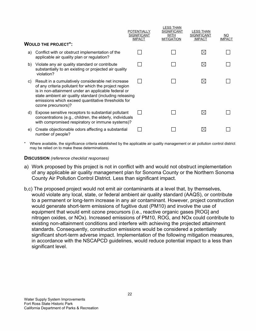
LESS THAN POTENTIALLY SIGNIFICANT LESS THAN SIGNIFICANT WITH SIGNIFICANT NO IMPACT MITIGATION IMPACT IMPACT WOULD THE PROJECT*: a) Conflict with or obstruct implementation of the applicable air quality plan or regulation?
b) Violate any air quality standard or contribute substantially to an existing or projected air quality violation?
c) Result in a cumulatively considerable net increase of any criteria pollutant for which the project region is in non-attainment under an applicable federal or state ambient air quality standard (including releasing emissions which exceed quantitative thresholds for ozone precursors)?
d) Expose sensitive receptors to substantial pollutant concentrations (e.g., children, the elderly, individuals with compromised respiratory or immune systems)?
e) Create objectionable odors affecting a substantial number of people? * Where available, the significance criteria established by the applicable air quality management or air pollution control district
may be relied on to make these determinations. DISCUSSION (reference checklist responses)
a) Work proposed by this project is not in conflict with and would not obstruct implementation of any applicable air quality management plan for Sonoma County or the Northern Sonoma County Air Pollution Control District. Less than significant impact.
b,c) The proposed project would not emit air contaminants at a level that, by themselves,
would violate any local, state, or federal ambient air quality standard (AAQS), or contribute to a permanent or long-term increase in any air contaminant. However, project construction would generate short-term emissions of fugitive dust (PM10) and involve the use of equipment that would emit ozone precursors (i.e., reactive organic gases [ROG] and nitrogen oxides, or NOx). Increased emissions of PM10, ROG, and NOx could contribute to existing non-attainment conditions and interfere with achieving the projected attainment standards. Consequently, construction emissions would be considered a potentially significant short-term adverse impact. Implementation of the following mitigation measures, in accordance with the NSCAPCD guidelines, would reduce potential impact to a less than significant level.

Water Supply System Improvements Fort Ross State Historic Park California Department of Parks & Recreation
23
MITIGATION MEASURES AIR-1 • All active construction areas would be watered at least twice daily during dry, dusty
conditions. Any activities that cause visible dust plumes that cannot be controlled by watering would be suspended.
• All trucks hauling soil, sand, or other loose materials would be covered or required to maintain at least two feet of freeboard.
• All equipment engines would be maintained in good condition, in proper tune (according to manufacturer's specifications), and in compliance with all State and federal requirements.
• Excavation and grading activities would be suspended when sustained winds exceed 25 mph; instantaneous gusts exceed 35 mph. Sweep all access points to existing paved roads with water sweepers at completion of daily activities if visible soil material is deposited onto the adjoining roads.
• Disturbed areas would be re-vegetated as quickly as feasible following completion of construction.
• Earth or other material that has been transported by trucking or earth moving equipment, erosion by water, or other means onto paved streets would be promptly removed.
d) Individuals or groups that would be especially reactive to pollutants are considered
sensitive receptors, such as children, the elderly, and those who are acutely or chronically ill. Facilities where these sensitive receptors are likely to be located include schools, playgrounds, childcare centers, retirement and convalescent homes, hospitals, medical clinics, and residences. The project is not located near any sensitive receptors, except for a single residence to the southwest. All schools are at least one-half mile from the project site. Any equipment use that could generate fugitive dust would be of limited duration, both in daily operation and as a percentage of the proposed work for this project. The project area would be closed to the public and it is expected that most or all of the work would occur during daylight hours. These conditions, combined with full implementation of the mitigation measures included in AIR-1 above, would result in a less than significant impact.
e) The proposed work would not result in the long-term generation of odors. Construction
related emissions could result in a short-term generation of odors, including diesel exhaust and fuel or solvent vapors. Some park personnel and adjacent residents might consider these odors objectionable. However, because construction activities would be short-term, odorous emissions would be limited and dissipate rapidly in the air, with increased distance from the source. The potential for impact during construction or operation of this project would be considered less than significant.

Water Supply System Improvements Fort Ross State Historic Park California Department of Parks & Recreation
24
THIS PAGE LEFT INTENTIONALLY BLANK
Water Supply System Improvements Fort Ross State Historic Park California Department of Parks & Recreation
25
IV. BIOLOGICAL RESOURCES ENVIRONMENTAL SETTING
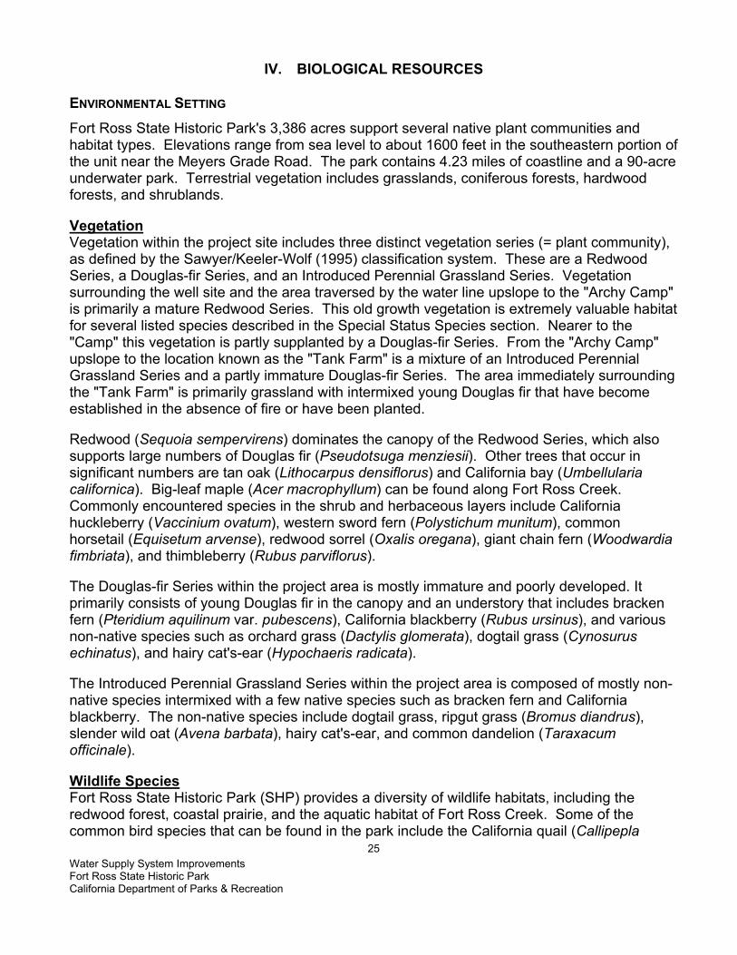
Fort Ross State Historic Park's 3,386 acres support several native plant communities and habitat types. Elevations range from sea level to about 1600 feet in the southeastern portion of the unit near the Meyers Grade Road. The park contains 4.23 miles of coastline and a 90-acre underwater park. Terrestrial vegetation includes grasslands, coniferous forests, hardwood forests, and shrublands. Vegetation Vegetation within the project site includes three distinct vegetation series (= plant community), as defined by the Sawyer/Keeler-Wolf (1995) classification system. These are a Redwood Series, a Douglas-fir Series, and an Introduced Perennial Grassland Series. Vegetation surrounding the well site and the area traversed by the water line upslope to the "Archy Camp" is primarily a mature Redwood Series. This old growth vegetation is extremely valuable habitat for several listed species described in the Special Status Species section. Nearer to the "Camp" this vegetation is partly supplanted by a Douglas-fir Series. From the "Archy Camp" upslope to the location known as the "Tank Farm" is a mixture of an Introduced Perennial Grassland Series and a partly immature Douglas-fir Series. The area immediately surrounding the "Tank Farm" is primarily grassland with intermixed young Douglas fir that have become established in the absence of fire or have been planted. Redwood (Sequoia sempervirens) dominates the canopy of the Redwood Series, which also supports large numbers of Douglas fir (Pseudotsuga menziesii). Other trees that occur in significant numbers are tan oak (Lithocarpus densiflorus) and California bay (Umbellularia californica). Big-leaf maple (Acer macrophyllum) can be found along Fort Ross Creek. Commonly encountered species in the shrub and herbaceous layers include California huckleberry (Vaccinium ovatum), western sword fern (Polystichum munitum), common horsetail (Equisetum arvense), redwood sorrel (Oxalis oregana), giant chain fern (Woodwardia fimbriata), and thimbleberry (Rubus parviflorus). The Douglas-fir Series within the project area is mostly immature and poorly developed. It primarily consists of young Douglas fir in the canopy and an understory that includes bracken fern (Pteridium aquilinum var. pubescens), California blackberry (Rubus ursinus), and various non-native species such as orchard grass (Dactylis glomerata), dogtail grass (Cynosurus echinatus), and hairy cat's-ear (Hypochaeris radicata). The Introduced Perennial Grassland Series within the project area is composed of mostly non-native species intermixed with a few native species such as bracken fern and California blackberry. The non-native species include dogtail grass, ripgut grass (Bromus diandrus), slender wild oat (Avena barbata), hairy cat's-ear, and common dandelion (Taraxacum officinale). Wildlife Species Fort Ross State Historic Park (SHP) provides a diversity of wildlife habitats, including the redwood forest, coastal prairie, and the aquatic habitat of Fort Ross Creek. Some of the common bird species that can be found in the park include the California quail (Callipepla

Water Supply System Improvements Fort Ross State Historic Park California Department of Parks & Recreation
26
californica), northern flicker (Colaptes auratus), Pacific-slope flycatcher (Empidonax difficilis), Stellar’s jay (Cyanocitta stelleri), winter wren (Troglodytes troglodytes), golden-crowned kinglet (Regulus satrapa), Swainson’s thrush (Catharus ustulatus), American robin (Turdus migratorius), and purple finch (Carpodacus purpureus). A number of common mammals live in the park including the western gray squirrel (Sciurus griseus), striped skunk (Mephitis mephitis), and mule deer (Odocoileus hemionus) (Mad River Biologists, 2003). In addition to these common wildlife species, a number of special-status wildlife species could potentially be found in the area. Special-Status Species1
Sensitive biological resources that occur or potentially occur on the proposed project site are discussed in this section. Sensitive biological resources include the plants and animals that have been given special recognition by federal, state, or local resource agencies and organizations. Also considered are habitats that are listed as critical for the survival of a listed species or have special value for wildlife, and plant communities that are unique or of limited distribution. All sensitive species and their habitats were evaluated for potential impacts by this project. A query of the California Department of Fish and Game’s Natural Diversity Database (CNDDB) was conducted for sensitive species and habitats within the Fort Ross and Plantation 7.5-minute USGS quadrangles. Special-status plant species potentially occurring in the two quadrangle maps were derived from the California Native Plant Society’s (CNPS) Inventory of Rare and Endangered Plants of California (6th edition, electronic version, 2001). Threatened and Endangered Species and Species of Special Concern Threatened and Endangered plants and animals and Species of Special Concern are special-status species that have legal protection. The following special-status species are the result of the CNDDB and CNPS queries for the quadrangle maps mentioned above and a review of available studies and literature. Plant Species -Special-status plant species that are known or that could potentially occur within or near the project area are based on the CNDDB (2003), the CNPS (6th edition, electronic version, 2001), and limited field observations by the California Department of Parks and Recreation natural resource staff. The CNDDB reports occurrences of 16 special-status plant species for the Fort Ross and Plantation 7.5-minute United States Geological Survey (USGS) quadrangles. The CNPS lists 24 special-status species (all CNPS List 1B or List 2) for the Fort Ross and Plantation quadrangles, of which four are described as. Combined, there are a total of 25 1 For the purposes of this document, special-status species are defined as plants and animals that are legally protected or that are considered sensitive by federal, state, or local resource conservation agencies and organizations. Specifically, this includes species listed as state or federally Threatened or Endangered, those considered as candidates for listing as Threatened or Endangered, species identified by the USFWS and/or CDFG as Species of Concern, animals identified by CDFG as Fully Protected or Protected, and plants considered by the California Native Plant Society (CNPS) to be rare, threatened, or endangered (i.e., plants on CNPS lists 1 and 2).

Water Supply System Improvements Fort Ross State Historic Park California Department of Parks & Recreation
27
possibly or probably extirpated from these quadrangles different special-status plant species reported by the CNDDB and the CNPS for the two quadrangles. Fifteen of these species appear on both lists. Suitable habitat does not exist within the project area for most of the 25 species. None of these species are currently known to occur in, or in the immediate vicinity of, the project area. Eight of the 25 species are restricted to serpentine habitat that does not exist within or near the project site. These are the Cedars manzanita (Arctostaphylos bakeri ssp. sublaevis), The Cedars fairy-lantern (Calochortus raichei), serpentine daisy (Erigeron serpentinus), Snow Mountain buckwheat (Eriogonum nervulosum), Three Peaks jewel-flower (Strepanthus morrisonii ssp. elatus), Dorr's Cabin jewel-flower (Strepanthus morrisonii ssp. hirtiflorus), Morrison's jewel-flower (Strepanthus morrisonii ssp. morrisonii), and secund jewel-flower (Strepanthus glandulosus var. hofmanii). Four other species, coastal bluff morning-glory (Calystegia purpurata ssp. saxicola), short-leaved evax (Hesperevax sparsiflora var. brevifolia), rose linanthus (Linanthus rosaceus), and perennial goldfields (Lasthenia macrantha ssp. macrantha), are limited to coastal dunes and/or coastal scrub habitats that are also not found within or near the project site. The project site and the surrounding area do not provide habitat required by supple daisy (Erigeron supplex), holly-leaved ceanothus (Ceanothus purpureus), Blasdale's bent grass (Agrostis blasdalei), Baker's goldfields (Lasthenia macrantha ssp. bakeri), and Sonoma spineflower (Chorizanthe valida). In addition, the CNDDB reports that the Sonoma spineflower is extirpated from Sonoma County. Podzolic soils essential for pygmy cypress (Cupressus goveniana ssp. pigmaea) do not occur within the park. Suitable habitat ranging from very marginal to fair exists for six species, none of which have been reported to occur within or near the project site. These species are described below. Plant Species with a Potential to Occur within the Project Area Coast lily (Lilium maritimum) - This CNPS list 1B species blooms from May through July and can occur in several different mesic habitat types, typically in coastal prairie, coastal scrub, bogs, and marshes. It is known to inhabit Marin, Sonoma, and Mendocino Counties. Although not reported from the area, there is suitable habitat within the project site for this species. Long-beard lichen (Usnea longissima) - This species is not rated by the CNPS, but is considered a special-status species by the CNDDB and is reported as probably occurring in Kolmer Gulch, which is more than a mile north of the project. Information for this plant is sparse, but it is known to grow in the "redwood zone" on a variety of trees such as big-leaf maple, Douglas fir, and California bay. Napa false indigo (Amorpha californica var. napensis) - Blooming from April through July, this CNPS List 1B plant occurs in Napa, Marin, Sonoma, and Monterey Counties. Napa false indigo inhabits chaparral, cismontane woodland, and openings in broad-leaved upland forest. The CNPS describes its lower elevation limit around 500 feet, which is nearly 200 feet higher than the project site. Although potential suitable habitat exists in the park, it is highly unlikely

Water Supply System Improvements Fort Ross State Historic Park California Department of Parks & Recreation
28
that this species exists within the project footprint or the immediate vicinity. Purple-stemmed checkerbloom (Sidalcea malviflora ssp. purpurea) - This CNPS List 1B species inhabits coastal prairie and broad-leaved upland forest in San Mateo, Sonoma, and Mendocino Counties. It blooms in May and is known to occur in coastal prairie habitat of the park just south of Kolmer Gulch. Marginally suitable habitat exists in or near the project site for purple-stemmed checkerbloom. Thin-lobed horkelia (Horkelia tenuiloba) - This CNPS List 1B species of Marin, Sonoma, and Mendocino Counties blooms from May through July. It occurs in sandy soils of chaparral and broad-leaved upland forest habitat. Very marginally suitable habitat may be present in or near the project site, but it is unlikely to occur there. Swamp harebell (Campanula californica) - Swamp harebell is a CNPS List 1B species that occupies mesic locations in various habitats, including coastal prairie, bogs, fens, and marshes. It has been reported from Marin, Sonoma, and Mendocino Counties. This species has a June through October blooming period. Although not reported from the park, suitable habitat exists within or near the project site. Wildlife Species with a Potential to Occur within the Project Area Special-status wildlife species that have been documented in Fort Ross SHP, and their potential to occur in or near the project area, are described below. Steelhead – Northern California Coast ESU (Oncorhynchus mykiss irideus). Fort Ross Creek provides important habitat for steelhead, a Federally Threatened species and California Species of Special Concern. This species has been documented in the project area, and could spawn in Fort Ross Creek in spring. Coho Salmon – Central California Coast ESU (Oncorhynchus kisutch) – Although there are no records in the CNDDB for this Federally Threatened species, the National Marine Fisheries “California Coastal Salmon and Steelhead Current Stream Habitat Distribution Table (2000)” lists two reports of Coho Salmon in Fort Ross Creek. Coho Salmon spawning migrations begin after heavy late-fall or winter rains, and in the short coastal streams of California, most Coho return during mid-November through mid-January (DFG, 1995). This species could be present in the project area. Foothill Yellow-legged Frog (Rana boylii). The CNDDB contains a recent record for foothill yellow-legged frog, a California Species of Special Concern, in Fort Ross Creek, in the project area (CDFG, 2003). This species requires shallow, flowing water in small to moderate-sized streams with at least some cobble-sized substrate (Jennings and Hayes, 1994). Northern Red-legged Frog (Rana aurora aurora). The northern red-legged frog, a California Species of Special Concern, could potentially occur in and near the aquatic and upland habitats of Fort Ross SHP. This frog breeds in permanent or temporary water bordered by dense grassy or shrubby vegetation, and can be found in adjacent upland habitat, such as sword ferns and sedges along streamside flats within coastal redwood forest (Jennings and Hayes, 1994).

Water Supply System Improvements Fort Ross State Historic Park California Department of Parks & Recreation
29
Northern Spotted Owl (Strix occidentalis). The federally threatened northern spotted owl resides in dense, old growth, multi-layered mixed conifer, redwood and Douglas-fir habitats (Zeinre et. al., 1990). Fort Ross SHP contains a large amount of suitable habitat for this species. Recent surveys conducted in the park located a male spotted owl in the project area (Mad River Biologists, 2003). Osprey (Pandion haliaetus). The CNDDB lists an osprey nest site in the Plantation Quad, at a water impoundment area in Timbercove. Osprey have been detected in Fort Ross SHP (Mad River Biologists, 2003), however, there are no nesting records in the park. This California Species of Special Concern builds large nests in treetops within 15 miles of water foraging habitat. White-tailed kite (Elanus leucurus). The white-tailed kite, a California Species of Special Concern and Fully Protected Species, is typically found in coastal and valley lowlands, and nests near the top of dense oak, willow, or other tree stands. This species has been recorded in Fort Ross SHP (Mad River Biologists, 2003). Sharp-shinned hawk (Accipiter striatus) (wintering); Cooper’s hawk (Accipiter cooperi); Merlin (Falco columbarius) (wintering); Northern harrier (Circus cyaneus). The project area contains potential foraging and nesting habitat for these raptor species, which are California Species of Special Concern. Peregrine falcon (Falco peregrinus). Peregrine falcons, which are state endangered and protected, are known to occur along the coast of California. This species is generally found near bodies of water in open areas with cliffs and canyons nearby for cover and nesting (Zeiner et. al., 1990). Peregrine falcons may fly over the project area at times, but no suitable cliff-nesting habitat is present in the vicinity of the project. Purple Martin (Progne subis). The purple martin is a California Species of Special Concern. This bird is an uncommon summer resident of wooded, low-elevation habitats throughout the state, including Douglas fir and redwood (Zeiner et. al., 1990). Purple martins have been recorded in Fort Ross SHP (Mad River Biologists, 2003), and could be present in the vicinity of the project area. Red Tree Vole (Arborimus pomo). The CNDDB lists an occurrence of two red tree vole nests near Fort Ross Creek, about 0.8 miles ENE of Fort Ross, in the vicinity of the project. This California Species of Special Concern lives in Douglas fir, redwood, and montane hardwood-conifer forests, and feeds almost exclusively on Douglas-fir needles (CDFG, 2003). Sonoma Arctic Skipper (Carterocephalus palaemon magnus). The CNDDB lists an occurrence of this species in the Plantation Quad, north of Fort Ross SHP and the project area. This species is associated primarily with redwood forest, and can be found in moist areas of woodland meadows, forest openings, trails and roadsides (Tilden and Smith, 1986). This species is not listed on any state or federal species of concern lists, but is noted in the CNDDB because it is of local concern. Although it has not been recorded in Fort Ross SHP, it could potentially occur in the park and the project area.

Water Supply System Improvements Fort Ross State Historic Park California Department of Parks & Recreation
30
Monarch Butterfly (Danaus plexippus). The CNDDB lists a number of monarch over-wintering and autumnal sites in the vicinity of Fort Ross SHP. The closest one to the project area is in the park, between the Call House and the parking lot at Fort Ross, in cypress and eucalyptus trees. This site is far enough from the project area that it will not be impacted by the project. Sensitive Natural Communities Sensitive natural plant communities are communities that are especially diverse, regionally uncommon, or of special concern to local, state and federal agencies. Elimination or substantial degradation of these communities would constitute a significant impact under CEQA. The Redwood and Douglas-fir Series within the project area are equivalent to rare natural communities, as determined by the CNDDB, since they are considered of high inventory priority. The Redwood Series is especially important since it contains mature forest components, including old growth redwood trees that provides valuable habitat for both common and special status wildlife species. Much of the Douglas-fir Series is immature or poorly developed; hence its value for wildlife is not as great as the redwood community. Wetland and Waters of the United States The U.S. Army Corps of Engineers (USACE) defines wetlands as areas that are inundated or saturated by surface or ground water at a frequency and duration sufficient to support, and under normal circumstances do support, a prevalence of vegetation typically adapted for life in saturated soil conditions. The majority of USACE jurisdictional wetlands meet three wetland delineation criteria: (1) hydrophytic vegetation, (2) hydric soil types, and (3) wetland hydrology. No areas that meet these criteria occur within the project footprint. However, the proposed project would include activities within Fort Ross Creek that potentially falls under USACE jurisdiction as Waters of the United States in that it has a defined stream "bed and bank". Currently DPR staff crosses the creek for maintenance of the park's well site.

Water Supply System Improvements Fort Ross State Historic Park California Department of Parks & Recreation
31
LESS THAN POTENTIALLY SIGNIFICANT LESS THAN SIGNIFICANT WITH SIGNIFICANT NO IMPACT MITIGATION IMPACT IMPACT
WOULD THE PROJECT: a) Have a substantial adverse effect, either directly or through habitat modification, on any species identified as a sensitive, candidate, or special status species in local or regional plans, policies, or regulations, or by the California Department of Fish and Game or the U.S. Fish and Wildlife Service?
b) Have a substantial adverse effect on any riparian habitat or other sensitive natural community identified in local or regional plans, policies, or regulations, or by the California Department of Fish and Game or the U.S. Fish and Wildlife Service?
c) Have a substantial adverse effect on federally protected wetlands, as defined by §404 of the Clean Water Act (including, but not limited to, marsh, vernal pool, coastal, etc.) through direct removal, filling, hydrological interruption, or other means?
d) Interfere substantially with the movement of any native resident or migratory fish or wildlife species or with established native resident or migratory wildlife corridors, or impede the use of native wildlife nursery sites?
e) Conflict with any local policies or ordinances protecting biological resources, such as a tree preservation policy or ordinance?
f) Conflict with the provisions of an adopted Habitat Conservation Plan, Natural Community Conservation Plan, or other approved local, regional, or state habitat conservation plan?
DISCUSSION (reference checklist responses)
a) (i) Steelhead and foothill yellow-legged frogs are present in Fort Ross Creek, and Coho salmon and northern red-legged frog s may be in the vicinity. The project requires equipment vehicles to cross the creek to upgrade the water treatment facilities. However, crossings of Fort Ross Creek to upgrade the well site would be limited and would not be a significant increase in number beyond the current trips for maintenance activities. Also, erosion and sediment runoff from construction activities into the creek could adversely affect sensitive fish and frog species. The following mitigation measure will reduce potential impacts to these species to less than significant.

Water Supply System Improvements Fort Ross State Historic Park California Department of Parks & Recreation
32
MITIGATION MEASURE BIO-1 (STEELHEAD, COHO SALMON, FOOTHILL YELLOW-LEGGED FROG, AND NORTHERN RED-LEGGED FROG) California Department of Fish and Game and National Marine Fisheries (NMFS)
would be consulted to ensure that BMPs are sufficient to protect sensitive fish and frog species.
Creek crossing during spring steelhead river entry and spawning (January to June) would be restricted in accordance with measures recommended by NMFS and DFG. If seasonal avoidance were not possible, a temporary creek crossing would be installed, or a biological monitor would be present during the times that project-related vehicles would be crossing Fort Ross Creek to watch for fish and frogs crossing in the creed area. If a fish or frog is seen in the crossing area, vehicles would be prohibited form crossing the creek until the animal moves at least 50 feet up or down stream from the road crossing.
A DPR-approved resource ecologist would conduct a training session for all project personnel prior to the start of construction. Instruction would cover identification of sensitive species and their habitat, and specific measures required to protect and avoid sensitive wildlife. Training would address general conservation measures, proper disposal and covering of trash and construction debris, and response to fluid spills. The training would be completed prior to authorizing personnel to work in the project area.
All open trenches would be covered or escape boards placed within the trenches at the end of each workday. A DPR-qualified resource ecologist would monitor trenches when filled in.
Best Management Practices (BMPs) would be implemented during construction to prevent any construction debris or sediment from leaving the project area and impacting adjacent habitat. Refer to Mitigation Measure GEO 2 Erosion Control, HYDRO 1 Water Quality, and HYDRO 2 Water.
a) (ii) Northern spotted owls are present within ¼ mile of the project area. No trees are being
removed as part of this project, however breeding spotted owls could be disturbed by noise from construction activities. The following mitigation measure will reduce impacts to this species to a less-than significant level. MITIGATION MEASURE BIO- 2 (NORTHERN SPOTTED OWL SEASONAL AVOIDANCE) Construction activities would not occur during the breeding season for the northern
spotted owl (February 1st – August 31st). The specific dates of the breeding season could be adjusted through consultations with USFWS based on the characteristics of the local population.
a) (iii) The red tree vole could potentially be present in trees in the project area. No trees will
be impacted by this project, so potential impacts to this species are less than significant. a) (iv) Sensitive raptors as well as purple martins could be present in the project area, and
could be nesting in the vicinity. Raptors and their nests are protected under the Fish and Game Code (Section 3503.5). Since construction would not occur during the breeding season for these species (March through August) because of mitigation measure BIO 2,

Water Supply System Improvements Fort Ross State Historic Park California Department of Parks & Recreation
33
potential impacts to these species would be less than significant. a) (v) The Sonoma arctic skipper could potentially occur in the project area, although it hasn’t
been recorded onsite. Potential habitat for this species exists throughout the park. This project will only temporarily impact a minimal amount of potential habitat for this species, so impacts will be less than significant.
a) (vi)There are five CNPS List 1B species and one CNDDB special-status plant species that have
reported occurrences within the Fort Ross and Plantation USGS 7.5-minute quadrangles. These are Napa false indigo, purple-stemmed checkerbloom, thin-lobed horkelia, coast lily, long-beard lichen, and swamp harebell. The likelihood of occurrence in the project area for the first three species is minimal, although marginal habitat exists there. Suitable habitat exists for the other three species. Implementation of the following mitigation measure would reduce impacts to a less than significant level. MITIGATION MEASURE BIO- 3 CNPS LIST 1B PLANT SPECIES Surveys would be conducted during the appropriate blooming months (or when species
can be unmistakably identified) for all CNPS List 1B and List 2 plant species that could potentially occur within the project area.
All occurrences of CNPS List 1B and List 2 species found within the project area would be mapped on project maps, flagged on the ground, and avoided if possible.
If significant unavoidable impacts would occur to CNPS List 1B or List 2 species as a result of project implementation, DPR would mitigate losses of habitat or individuals at a ratio of 3:1 through habitat enhancement for these species within the Fort Ross State Historic Park (or as negotiated with the California Department of Fish and Game).
b) Redwood and Douglas-fir Series are sensitive natural plant communities that occur within the
project footprint. They could be impacted by implementation of the proposed project. Impacts could include, but not be limited to, damage to roots of mature native trees from trenching for an improved water line. Implementation of the following mitigation measure would reduce impacts to a less than significant level.
MITIGATION MEASURE BIO- 4 SENSITIVE NATURAL COMMUNITIES Within the structural root zone of any native tree with a dbh (diameter at breast
height) of 24 inches or greater, no roots with a diameter of 1 inch or greater would be cut by trenching activities. In these areas, it would be permissible to tunnel under the structural root zone at a depth equal to or greater than 3 feet. It would also permissible to remove soil by hand form roots that are larger than 1 inch in diameter.
c) As defined by the USACE, the proposed project would include activities within or adjacent to
Fort Ross Creek, which potentially falls under USACE jurisdiction as Waters of the United States in that it has a defined stream "bed and bank." These activities would include, but not be limited to, vehicular crossing of the creek to access the well site and improvements to the existing water line support structures across the creek and on the south bank of the stream. Crossings of Fort Ross Creek to upgrade the well site would be limited, and would not be a
Water Supply System Improvements Fort Ross State Historic Park California Department of Parks & Recreation
34
significant increase in number beyond the current trips for maintenance activities. The impacts to Fort Ross Creek resulting from improvements to the water line support structures are also determined to be less than significant since no excavation, dredge or fill activities would occur within the bed and bank. Prior to project construction, informal consultation with the USACE would be conducted to address any concerns regarding this project. Less than significant impact.
d) This project could temporarily impede the movement of native steelhead and Coho salmon
in Fort Ross Creek, if equipment went into the creek while fish are spawning. However, implementation of Mitigation Measure BIO-1 would reduce this impact to less than significant.
e) This project does not conflict with any local policies or ordinances protecting biological resources. No impact.
f) This project does not conflict with any Habitat Conservation Plans, Natural Communities Conservation Plans, or other approved habitat conservation plan. No impact.
Water Supply System Improvements Fort Ross State Historic Park California Department of Parks & Recreation
35
V. CULTURAL RESOURCES ENVIRONMENTAL SETTING
Fort Ross State Historic Park is located on the Sonoma County coast approximately 11 miles northwest of the town of Jenner on State Highway 1. The park unit currently contains 3,386 acres, 4.23 miles of coastline and 90 acres of submerged and tideland under a long-term lease from the State Lands Commission. Fort Ross lies on a one-third mile wide coastal terrace between precipitous cliffs that drop 100 feet to the ocean and coastal slopes that climb to 1500 feet in elevation. The Area of Potential Effects (APE) for the proposed Water Supply System Improvement Project encompasses a long linear swath beginning at Ft. Ross Creek due north of the Fort Ross complex and continuing East-South-East (ESE) along a prominent ridge line running between 200 and 315 feet above sea level (ASL). The objectives related to this proposed project center, primarily, on the upgrade of the existing water system and thus more underground construction Archaeological Resources Archaeological survey and testing programs at CA-SON-670 since 1971 document a prehistoric/protohistoric Native American habitation site. Prehistoric (Protohistoric) Archaeological Resources: One archaeological site-CA-SON-670, falls within the current project's Area of Potential Effect (APE). The site boundary involves a 3750 sq. meter area. In addition, historic features were noted that suggest a historic logging operation. Stillinger's (1975) analysis of the nail types recovered from CA-SON-670 suggests the land use post-dates A.D. 1870. The archaeology of CA-SON-670 represents a 'flow-of-history' and would be potentially eligible for Criterion D. The potential information of Site CA-SON-670 includes prehistoric Native American habitation. Artifacts from this site also suggest a protohistoric Native American habitation site with possible interaction with non-Indians. In addition, historic artifacts likely relating to the historic mill operation have also been discovered there. Historic Resources An 1876 U.S. Coast Survey Map illustrates a mill complex in the vicinity of CA-SON-670. Historic archaeological materials recovered from the site of CA-SON-670 relate to this time period and may be associated with this historic mill site. The James Dixon and Charles Fairfax logging operation was likely utilizing the water from the creek. According to Lynn Rudy, a local historian, the three structures as depicted on the ridge south of (historic) Fort Ross Gulch (now Fort Ross Creek) on Map No. 3 from the 1877 Historical Atlas of Sonoma County represent part of James Dixon's Mill. The structures likely represent housing for the workers including James Dixon's 'white house'. This location falls within the current project's APE. Although there is no surface evidence of these structures subsurface archaeological features and/or artifacts may be present in the immediate area of where these structures once stood.

Water Supply System Improvements Fort Ross State Historic Park California Department of Parks & Recreation
36
Historic documents and landform features correlate to Russian and Post-Russian Period land-use over time. Russians traveled up the old "Russian Road' to cut lumber and to access the upland grazing lands of the Fort complex. Later, after the Russians abandoned the Fort, non-Russian landowners ( John Sutter, a Swiss; William Benitz, a German; and Charles Fairfax, a Virginian) possibily utilized this ridge zone with the help of their labor force for ranching and/or agricultural pursuits. The Mexican Government never recognized Sutter's ownership and in 1844 Benitz formally purchased the 17,500-acre Mexican Land Grant property from Manuel Torres. This property stretched for approximately six miles all the way from the Russian River to Timber Cove (north of Ft. Ross). Russian livestock still left behind, he had in 10 years time about 1000 head of cattle, 200 horses, and 900 sheep. He grew wheat, oats, and potatoes, brewed his own beer, developed a coalmine, and laid out a new orchard with about 1700 trees. About 100 Indian families provided the chief labor force. In 1867 Benitz sold the property to Charles Fairfax. Fairfax and his partner, James Dixon were the first Americans to develop an extensive lumber industry at Fort Ross. In 1873 G.W. Call became owner ranchers. All of the Historic Resources mentioned above may be a potential Historic Landscape that could meet the criteria standards as an eligible Cultural Landscape. Cultural Landscape A cultural landscape is defined as a "concrete and characteristic product of the complicated interplay between a given human community, embodying certain cultural preferences and potentials, and a particular set of natural circumstances. It is the heritage of many eras of natural evolution and of many generations of human effort" (Wagner and Mikesell 1962). Birnbaum (1994) has further defined this human geography and developed four general types of cultural landscapes currently utilized by the National Park Service in the interpretation and evaluation of our nation's cultural heritage. The four types, not mutually exclusive, are: historic sites, historic designed landscapes, historic vernacular landscapes and ethnographic landscapes. The 'First Ridge Zone' appears to represent a potential Russian and post-Russian historic vernacular landscape. This landscape includes portions of the ridge including a known prehistoric/protohistoric Native American habitation site and portions of the Dixon-Fairfax mill complex. Previous documentation shows that this land is potentially eligible as a cultural landscape because it contains an archaeological record of the Native American culture and a history of non-Indian land-use overtime. In addition to this documentation, an aerial photograph appears to depict a faint feature that may represent a segment of the documented 'Old Russian road' . This area may have also been utilized as the log-chute that transported the lumber from the mill down to Ft. Ross Cove. To this end, the Ft. Ross Creek/First Ridge Zone juncture (FTC/FRZ) may be a potential Historic District that could meet the criteria for eligibility as a Cultural Landscape under
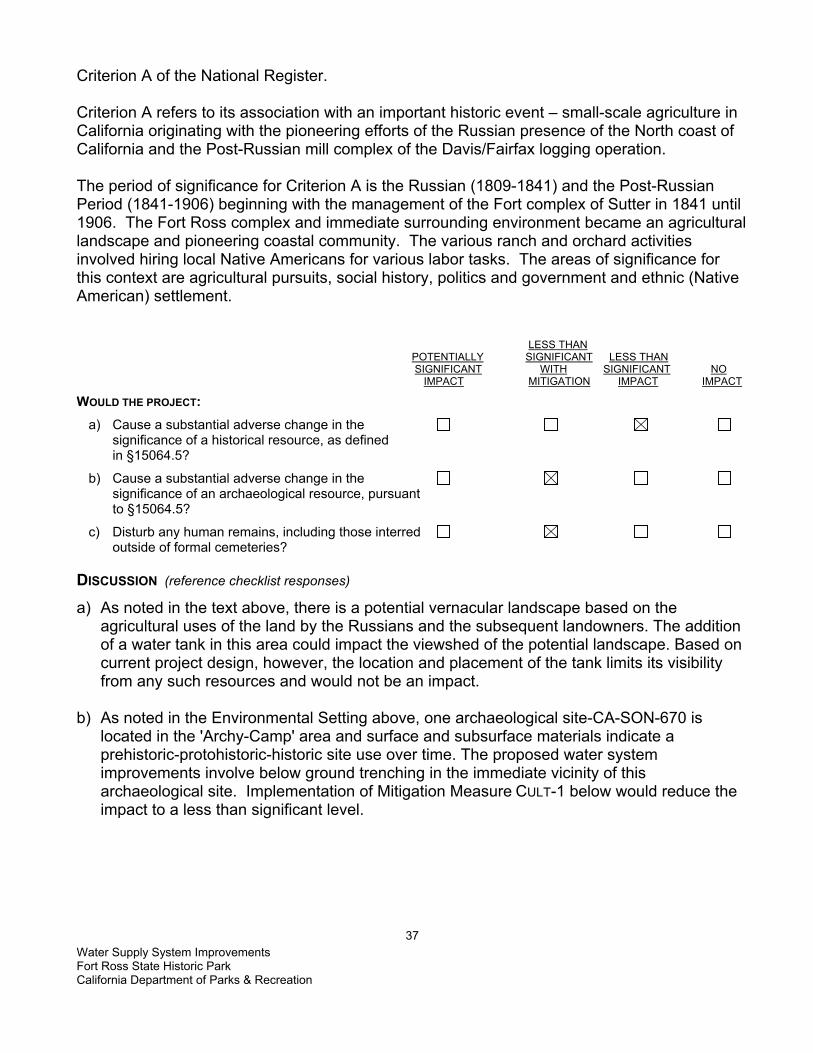
Water Supply System Improvements Fort Ross State Historic Park California Department of Parks & Recreation
37
Criterion A of the National Register. Criterion A refers to its association with an important historic event – small-scale agriculture in California originating with the pioneering efforts of the Russian presence of the North coast of California and the Post-Russian mill complex of the Davis/Fairfax logging operation. The period of significance for Criterion A is the Russian (1809-1841) and the Post-Russian Period (1841-1906) beginning with the management of the Fort complex of Sutter in 1841 until 1906. The Fort Ross complex and immediate surrounding environment became an agricultural landscape and pioneering coastal community. The various ranch and orchard activities involved hiring local Native Americans for various labor tasks. The areas of significance for this context are agricultural pursuits, social history, politics and government and ethnic (Native American) settlement. LESS THAN POTENTIALLY SIGNIFICANT LESS THAN SIGNIFICANT WITH SIGNIFICANT NO IMPACT MITIGATION IMPACT IMPACT WOULD THE PROJECT: a) Cause a substantial adverse change in the significance of a historical resource, as defined in §15064.5?
b) Cause a substantial adverse change in the significance of an archaeological resource, pursuant to §15064.5?
c) Disturb any human remains, including those interred outside of formal cemeteries? DISCUSSION (reference checklist responses)
a) As noted in the text above, there is a potential vernacular landscape based on the agricultural uses of the land by the Russians and the subsequent landowners. The addition of a water tank in this area could impact the viewshed of the potential landscape. Based on current project design, however, the location and placement of the tank limits its visibility from any such resources and would not be an impact.
b) As noted in the Environmental Setting above, one archaeological site-CA-SON-670 is
located in the 'Archy-Camp' area and surface and subsurface materials indicate a prehistoric-protohistoric-historic site use over time. The proposed water system improvements involve below ground trenching in the immediate vicinity of this archaeological site. Implementation of Mitigation Measure CULT-1 below would reduce the impact to a less than significant level.

Water Supply System Improvements Fort Ross State Historic Park California Department of Parks & Recreation
38
MITIGATION MEASURE CULT-1 The project's APE would be surface surveyed with periodic surface scrapes in areas where ground visibility is poor. The survey would occur prior to the start of construction and ground disturbance. If previously unrecorded sites are located during the survey, the project would be modified, in consultation with the DPR cultural specialist to avoid impacts to the site(s) or reduce potential impacts to a less than significant level. The Ft. Ross Creek/Front Range Zone (FRC/FRZ) juncture may involve subsurface historic archaeological features or objects that are associated with the location of three historic sites, including the Davis 'white house'. Implementation of Mitigation Measure CULT-2 below would reduce the impact to a less than significant level.
MITIGATION MEASURE CULT-2 Prior to any below ground trenching, an Archaeologist that meets the Secretary of Interior’s minimum qualification standards in historic archaeology would dig shovel test units along the proposed (new) tank siting and linear transects of the water line. If any cultural materials were discovered, the location of the tank site and pipe connections would be adjusted to avoid disturbing the sites. If there were no way to avoid impacting the site, then the site would be fully recorded and tested for significance prior to the excavation. Archaeological monitoring would occur during all ground disturbing activities.
c) Burials have not been documented or recorded in the APE; however, there is always a
potential of unanticipated discoveries of human bone. If any human remains or burial artifacts were identified, implementation of Mitigation Measures CULT-3 below would reduce the impact to a less than significant level.

Water Supply System Improvements Fort Ross State Historic Park California Department of Parks & Recreation
39
MITIGATION MEASURE CULT-3 In the event that human remains were discovered, work would cease immediately in the area of the find and the project manager/site supervisor would notify the appropriate DPR personnel. Any human remains and/or funerary objects would be left in place or returned to the point of discovery and covered with soil. The DPR Sector Superintendent (or authorized representative) would notify the County Coroner, in accordance with §7050.5 of the California Health and Safety Code, and the Native American Heritage Commission (or Tribal Representative). If a Native American monitor is on-site at the time of the discovery, the monitor would be responsible for notifying the appropriate Native American authorities. The local County Coroner should make the determination of whether the human bone is of Native American origin. In many of California's historic townsites and rural communities discoveries have been made of non-Native American human bone including non-Anglo. If the coroner or tribal representative determines the remains represent Native American interment, the NAHC in Sacramento and/or tribe would be consulted to identify the most likely descendants and appropriate disposition of the remains. Work would not resume in the area of the find until proper disposition is complete (PRC §5097.98). No human remains or funerary objects would be cleaned, photographed, analyzed, or removed from the site prior to determination If it is determined the find indicates a sacred or religious site, the site would be avoided to the maximum extent practicable. Formal consultation with the State Historic Preservation Office and review by the Native American Heritage Commission/Tribal Cultural representatives would also occur as necessary to define additional site mitigation or future restrictions.

Water Supply System Improvements Fort Ross State Historic Park California Department of Parks & Recreation
40
This page left intentionally blank

Water Supply System Improvements Fort Ross State Historic Park California Department of Parks & Recreation
41
VI. GEOLOGY AND SOILS ENVIRONMENTAL SETTING
Topography The overall topography of Fort Ross ranges from sea level along to coast, to 1,500 feet msl (median sea level) (see Appendix A, Figure G-1). Eastward from the coastal bluffs through Fort Ross SHP and the LP Fiberboard Property, to the top of the first ridge, the topography changes from flat, young coastal terraces to steep, deeply incised uplifted terraces. The San Andreas Fault Zone demarks this change in topography. The area west of State Route 1 has low relief and slopes gently seaward, characteristic of a young, last-emergent marine terrace. The elevation in this area ranges from about 50 feet msl at the bluffs to about 200 feet msl at the highway. East of State Route 1 to the San Andreas Fault Zone, low sloping hills characterize the topography with elevations ranging from 200 to 300 feet msl. East of the San Andreas Fault Zone, the topography becomes characteristic of incised canyons and steep slopes. At the top of the ridge, the topography is less sloped and characteristic of uplifted, ancient coastal bedrock terraces (ESA, 2003). Regional Geology Fort Ross State Historic Park (Fort Ross SHP) is located within the California Coast Range Geomorphic Province, a northwest trending chain of mountains that formed primarily as a result of movement along the San Andreas Fault and associated faults. The San Andreas Fault cuts through the center of Fort Ross SHP and this project location. The predominant geologic rock units east of the San Andreas Fault Zone are also the oldest rocks exposed at Fort Ross SHP and are referred to as the Franciscan Formation1. Some of the rocks in the Franciscan Formation became sheared, crushed, and folded into a chaotic mix commonly referred to as a “mélange.” Regionally, the Franciscan Formation mélange contains shale, sandstone, metamorphic rocks including greenstone, and serpentinite. West of the San Andreas Fault are the rocks of the Gualala Block, the northern portion of the Salinian Block that forms much if the Central California coastline. Salinian Block rocks consist of Jurassic to Cretaceous age (see Appendix A, Figure G-2) granitic and metamorphic rocks that formed some 350 miles to the south and began moving north during the Miocene (26 to 7 million years ago) as the San Andreas Fault was activated. This block of land continues to move in a relative northerly direction along the northeast trending San Andreas Fault Zone. Between 54 and 2 million years ago, while the Coast Ranges were slowly rising and becoming dry land, it is believed that the seas periodically inundated the area, depositing a variety of sedimentary rocks over the crystalline basement rocks. In the area around Fort Ross SHP, the inundation of seas, as well as coastal uplift, resulted in two distinct geologic units, the German Rancho Formation (36 to 65 million years old) and the Gallaway Formation (23 to 7 million years old) (ESA, 2003).
1 The Franciscan Formation contains predominately sedimentary to meta-sedimentary rocks with lesser amounts of greenstone (metamorphosed volcanic rocks), pillow basalt, and blueschist. These rocks formed when sea floor sediments washed into deep ocean trench-like depressions along the continental margin and were later uplifted and accreted to the continent.
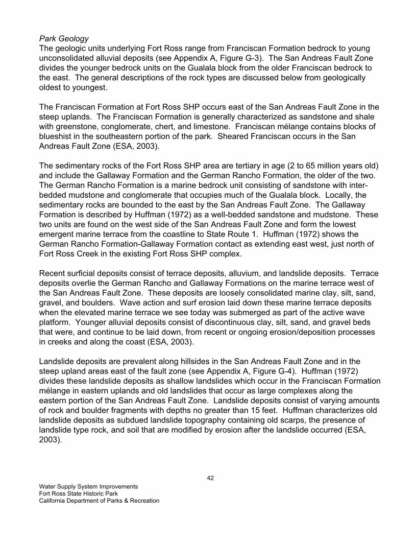
Water Supply System Improvements Fort Ross State Historic Park California Department of Parks & Recreation
42
Park Geology The geologic units underlying Fort Ross range from Franciscan Formation bedrock to young unconsolidated alluvial deposits (see Appendix A, Figure G-3). The San Andreas Fault Zone divides the younger bedrock units on the Gualala block from the older Franciscan bedrock to the east. The general descriptions of the rock types are discussed below from geologically oldest to youngest. The Franciscan Formation at Fort Ross SHP occurs east of the San Andreas Fault Zone in the steep uplands. The Franciscan Formation is generally characterized as sandstone and shale with greenstone, conglomerate, chert, and limestone. Franciscan mélange contains blocks of blueshist in the southeastern portion of the park. Sheared Franciscan occurs in the San Andreas Fault Zone (ESA, 2003). The sedimentary rocks of the Fort Ross SHP area are tertiary in age (2 to 65 million years old) and include the Gallaway Formation and the German Rancho Formation, the older of the two. The German Rancho Formation is a marine bedrock unit consisting of sandstone with inter-bedded mudstone and conglomerate that occupies much of the Gualala block. Locally, the sedimentary rocks are bounded to the east by the San Andreas Fault Zone. The Gallaway Formation is described by Huffman (1972) as a well-bedded sandstone and mudstone. These two units are found on the west side of the San Andreas Fault Zone and form the lowest emergent marine terrace from the coastline to State Route 1. Huffman (1972) shows the German Rancho Formation-Gallaway Formation contact as extending east west, just north of Fort Ross Creek in the existing Fort Ross SHP complex. Recent surficial deposits consist of terrace deposits, alluvium, and landslide deposits. Terrace deposits overlie the German Rancho and Gallaway Formations on the marine terrace west of the San Andreas Fault Zone. These deposits are loosely consolidated marine clay, silt, sand, gravel, and boulders. Wave action and surf erosion laid down these marine terrace deposits when the elevated marine terrace we see today was submerged as part of the active wave platform. Younger alluvial deposits consist of discontinuous clay, silt, sand, and gravel beds that were, and continue to be laid down, from recent or ongoing erosion/deposition processes in creeks and along the coast (ESA, 2003). Landslide deposits are prevalent along hillsides in the San Andreas Fault Zone and in the steep upland areas east of the fault zone (see Appendix A, Figure G-4). Huffman (1972) divides these landslide deposits as shallow landslides which occur in the Franciscan Formation mélange in eastern uplands and old landslides that occur as large complexes along the eastern portion of the San Andreas Fault Zone. Landslide deposits consist of varying amounts of rock and boulder fragments with depths no greater than 15 feet. Huffman characterizes old landslide deposits as subdued landslide topography containing old scarps, the presence of landslide type rock, and soil that are modified by erosion after the landslide occurred (ESA, 2003).

Water Supply System Improvements Fort Ross State Historic Park California Department of Parks & Recreation
43
Soils The main soil associations located at Fort Ross SHP and their specific characteristics are summarized in Table 1. The Hugo and Josephine soil series (shallow, well-drained loam and gravelly loam) cover the majority of the SHP and are located in steeply sloped, heavily wooded ridges and canyons at elevations ranging from 800 to 3,000 feet msl. Laughlin soils are similar to the Hugo and Josephine soil series although bedrock is shallower and overlying vegetation consists of intermixed grasses and timber. Yorkville series soils (moderately well drained clay loams) are located in the northeastern grassland portion of the Fort Ross SHP on steep mountain uplands at elevations of 300 to 2,500 feet. The Kinman and Kneeland series (loamy and clay loam soils) are found in hilly uplands located in the western region of the Fort Ross SHP at elevations ranging from 100 to 1,500 feet msl. The Rohnerville series (moderately well-drained loam and silt loam) within the SHP is located on gently sloping marine terraces north of the Historical Monument and along the shoreline from Northwest Cape to the northern boundary of Fort Ross SHP at elevations ranging from 100 to 1,000 feet msl. The coastline around Fort Ross Cove is mapped as Terrace Escarpments or Coastal Beaches. Well-developed soils are essentially absent in these areas, rendering classification of soil properties unfeasible (USDA, 1972 in ESA, 2003).
Table 1 - Soil Properties
Soil Series Typical Soil Profile with USCS Classification
Corrosivity Erosion Potential
Shrink-Swell Potential
Hugo Loam 0-48”: loam & sandy clay loam (CL) 48”: sandstone bedrock
Moderate High Moderate
Hugo gravelly Loam
0-48”: gravelly loam & gravelly sandy clay loam (SC) 48”: sandstone bedrock
Moderate High to very high
Moderate
Kinman Loam 0-12 ‘: loam & clay loam (CL) High Slight to high High Kneeland Loam 0-13”: loam (CL)
13-35”: clay loam (CL) 35”: sandstone bedrock
Moderate Moderate to high
Moderate
Josephine Loam 0-13”: loam (CL or ML) 13-25”: clay loam (CL) 25-36”: fine sandy loam (SM) 36”: sandstone bedrock
Moderate High to very high
Low
Laughlin-Yorkville Complex
0-22”: loam & sandy clay loam (SC) 22”; sandstone, shale, metamorphic bedrock
Moderate High to very high
Moderate
Rohnerville Loam
0-16”: loam & silt loam (ML or CL) Moderate to high
Slight to High Moderate
Yorkville Clay Loam
0-14”: clay loam (CL) 14-60”: clay (CH)
High High High
Seismicity The most significant, well-represented geologic feature within Fort Ross is the San Andreas Fault Zone. The fault zone affects the local seismicity, much of the topographic characteristics, and the local drainage patterns. This zone is a tectonic boundary between the North American Plate to the east and the Pacific Plate to the west. The San Andreas Fault Zone comes on land approximately 8,000 feet south of Fort Ross SHP historic zone and continues up the coast
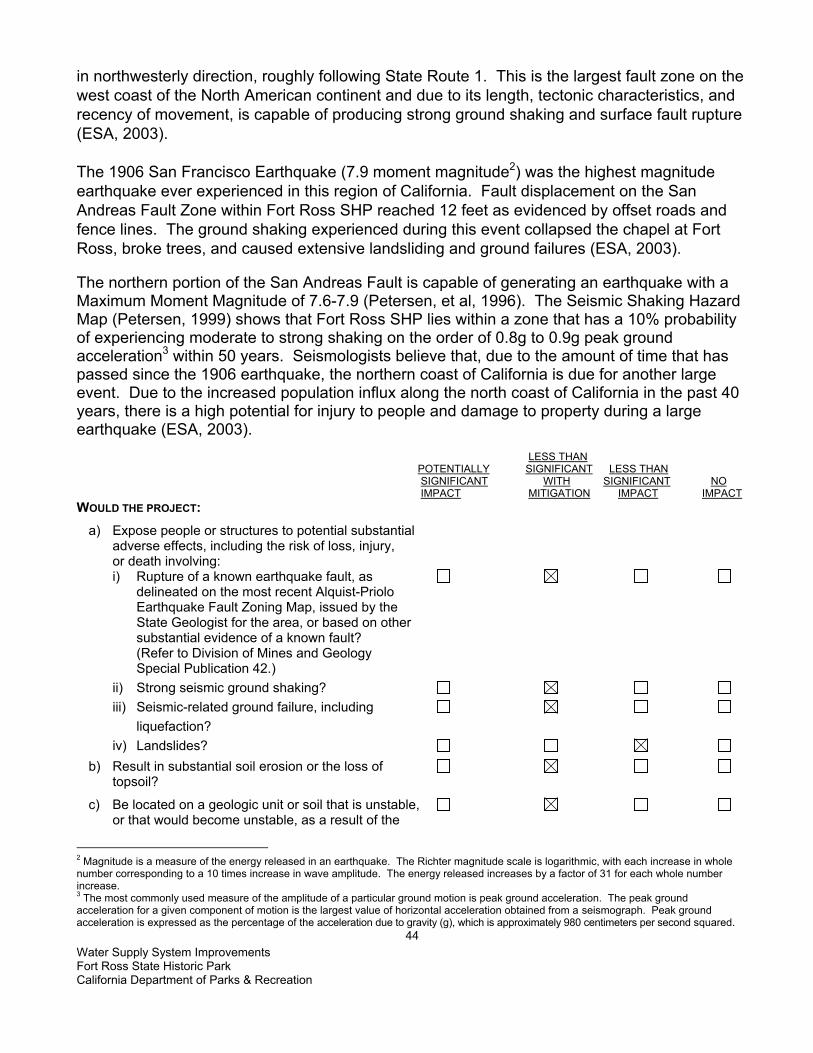
Water Supply System Improvements Fort Ross State Historic Park California Department of Parks & Recreation
44
in northwesterly direction, roughly following State Route 1. This is the largest fault zone on the west coast of the North American continent and due to its length, tectonic characteristics, and recency of movement, is capable of producing strong ground shaking and surface fault rupture (ESA, 2003). The 1906 San Francisco Earthquake (7.9 moment magnitude2) was the highest magnitude earthquake ever experienced in this region of California. Fault displacement on the San Andreas Fault Zone within Fort Ross SHP reached 12 feet as evidenced by offset roads and fence lines. The ground shaking experienced during this event collapsed the chapel at Fort Ross, broke trees, and caused extensive landsliding and ground failures (ESA, 2003). The northern portion of the San Andreas Fault is capable of generating an earthquake with a Maximum Moment Magnitude of 7.6-7.9 (Petersen, et al, 1996). The Seismic Shaking Hazard Map (Petersen, 1999) shows that Fort Ross SHP lies within a zone that has a 10% probability of experiencing moderate to strong shaking on the order of 0.8g to 0.9g peak ground acceleration3 within 50 years. Seismologists believe that, due to the amount of time that has passed since the 1906 earthquake, the northern coast of California is due for another large event. Due to the increased population influx along the north coast of California in the past 40 years, there is a high potential for injury to people and damage to property during a large earthquake (ESA, 2003). LESS THAN POTENTIALLY SIGNIFICANT LESS THAN SIGNIFICANT WITH SIGNIFICANT NO IMPACT MITIGATION IMPACT IMPACT WOULD THE PROJECT: a) Expose people or structures to potential substantial adverse effects, including the risk of loss, injury, or death involving: i) Rupture of a known earthquake fault, as delineated on the most recent Alquist-Priolo Earthquake Fault Zoning Map, issued by the State Geologist for the area, or based on other substantial evidence of a known fault? (Refer to Division of Mines and Geology Special Publication 42.) ii) Strong seismic ground shaking? iii) Seismic-related ground failure, including liquefaction? iv) Landslides? b) Result in substantial soil erosion or the loss of topsoil?
c) Be located on a geologic unit or soil that is unstable, or that would become unstable, as a result of the
2 Magnitude is a measure of the energy released in an earthquake. The Richter magnitude scale is logarithmic, with each increase in whole number corresponding to a 10 times increase in wave amplitude. The energy released increases by a factor of 31 for each whole number increase. 3 The most commonly used measure of the amplitude of a particular ground motion is peak ground acceleration. The peak ground acceleration for a given component of motion is the largest value of horizontal acceleration obtained from a seismograph. Peak ground acceleration is expressed as the percentage of the acceleration due to gravity (g), which is approximately 980 centimeters per second squared.

Water Supply System Improvements Fort Ross State Historic Park California Department of Parks & Recreation
45
project and potentially result in on- or off-site landslide, lateral spreading, subsidence, liquefaction, or collapse?
d) Be located on expansive soil, as defined in Table 18-1-B of the Uniform Building Code (1997), creating substantial risks to life or property?
e) Have soils incapable of adequately supporting the use of septic tanks or alternative waste disposal systems, where sewers are not available for the disposal of waste water?
f) Directly or indirectly destroy a unique paleontological resource or site, or unique geologic feature? DISCUSSION (reference checklist responses)
a) A fault rupture hazard zone was established for the San Andreas under the Alquist-Priolo Earthquake Fault Zoning Act4 (APEFZ Act) of 1972. The delineated fault zone (see Figure G-5) ranges between 500 and 1,000 feet in width on either side of both the active, confirmed trace and the inferred trace. The purpose of this law is to mitigate the hazard of surface fault rupture by regulating development near active faults. Development is limited in areas defined as Earthquake Hazard Zones, and structures for human occupancy (2,000 person hours annually) are generally not permitted. i) Portions of the Fort Ross SHP project site, including the groundwater well and
associated piping and electrical, are located within the San Andreas Fault Zone and within the designated Earthquake Hazard Zone (see Appendix A, Figure G-5). The water line from the well is underground below Fort Ross Creek (first creek crossing) and crosses the San Andreas Fault. This segment of the fault ruptured in the 1906 earthquake and the ground surface was displaced up to 12 feet horizontally. The potential for ground surface rupture is a possibility during an earthquake. There is no increased risk to the public or to property from this project, because it is an existing condition. The possibility exists for damage to the water line from the well and the electrical supply line. Mitigation to prevent breakage of the water line, if surface rupture were to occur, is not possible. Some water may be released to the creek in the event of a rupture. The well will most likely cease pumping, since the electrical supply will most likely fail as well. Mitigation Measure GEO 1 below would mitigate for risks in the event of a large earthquake.
ii) The California Geological Survey has determined that the northern segments of the San Andreas Fault Zone are capable of generating an earthquake with a Maximum Moment Magnitude of 7.6-7.9 (Petersen, et al, 1996. The expected ground acceleration at the project site is on the order of 0.8g to 0.9g (Petersen, 1999). Regardless of the predicted peak ground acceleration values, if a major earthquake occurred on the San Andreas Fault Zone in the north coast area, Fort Ross SHP would be affected by strong to violent ground shaking that could result in considerable damage and permanent ground
4 The APEFZ Act is the State law that addresses hazards from earthquake fault zones. The APEFZ Act requires the identification of zones along sufficiently active and well-defined faults. Development proposals in an Earthquake Hazard Zone require detailed geologic/seismic hazard evaluations prior to issuance of a use permit

Water Supply System Improvements Fort Ross State Historic Park California Department of Parks & Recreation
46
displacement (ESA, 2003). There would be no increased risk to the public or to structures due to this project provided the proposed new water tank is built to withstand major damage during a strong earthquake. Implementation of Mitigation Measure GEO-1 below would insure a less than significant impact.
iii) Seismic-induced ground failure, such as liquefaction, usually occurs in unconsolidated
granular soils that are water saturated. During seismic-induced ground shaking, pore water pressure can increase in loose soils, causing the soils to change from a solid to a liquid state (liquefaction). The upper soils in the project area may be loose and certain areas may be saturated during the winter months. The areas within Fort Ross Creek channel and floodplain are susceptible to liquefaction. No tanks or buildings exist or are planned for that area. The location for the new water tank is not known to be in a liquefaction prone area, but no site specific soils data or liquefaction analyses have been preformed. Implementation of Mitigation Measure GEO 1 would reduce this impact to less than significant. The CBC/UBC would typically be indicated, but American Water Works Association (AWWA) incorporates more stringent and specific requirements for seismic practice in water tank design.
Mitigation Measure Geo-1 – Seismic Building Requirements The proposed water tank must conform to earthquake design requirements. Tank
and foundation design would follow the applicable regulations and design practices of the American Water Works Association Design Standards.
Any new equipment installed as part of the water system treatment upgrades would be secured to the walls and/or floor in the existing water treatment building to prevent damage in the event of a large earthquake.
State Park staff would inspect the water supply system for damage as soon as feasible after a large earthquake.
iv) While landslides have been mapped in the steeper regions of Fort Ross SHP (see
Appendix A, Figure G-4), no landslides have been mapped within the project area. Therefore, there is less than significant impact from a seismically triggered landslide.
b) A temporary increase in erosion may occur during the phases of this project during grading
for the water tank foundation, trenching for utility lines, installation of anchoring devices for the above ground water line crossing of Fort Ross Creek, and any other ground disturbing activities. Implementation of Mitigation Measure GEO-2 below will reduce soil erosion or loss of topsoil by the proposed project to a less than significant level.

Water Supply System Improvements Fort Ross State Historic Park California Department of Parks & Recreation
47
MITIGATION MEASURE GEO 2 EROSION CONTROL BMPs would be used in all areas to control soil and surface water runoff during
excavation, grading, and trenching. Grading and excavation activities would not be planned during the rainy season (October 31 to May 1), but if storms are anticipated during construction or if construction must occur during winter months, “winterizing” would occur, including the covering (tarping) of any stockpiled soils and the use of temporary erosion control methods to protect disturbed soil. Temporary erosion control measures (BMPs) must be used during all soil disturbing activities and until all disturbed soil has been stabilized (re-compacted, re-vegetated, etc.) These BMPs would include, but not be limited to, the use of silt fences, straw bales, or straw or rice coir rolls, to prevent soil loss and siltation into nearby water bodies.
Permanent BMPs for erosion control would consist of properly compacting disturbed areas and re-vegetation of appropriate disturbed soil areas with native species using seed collected locally. Final design plans will incorporate BMP measures to be incorporated into the project.
The project would meet or exceed all applicable local building and engineering regulations/ordinances required by Sonoma County.
c) The project is not located within a geologic unit or soil that is known to be unstable, based
upon available data. As discussed on section a iii above, a slight potential for liquefaction may exist at the project location. Implementation of Mitigation Measure GEO 1 above will reduce this risk to less than significant.
d) Expansive soils may exist in the project area, as the majority of the soil unit present have
moderate to high shrink-swell potential (USDA, 1972). The project site is located in areas mapped as Hugo, with some Kinman and Rohnerville (USDA, 1972). These soils have moderate shrink-swell potential. These soils are also rated as moderate to high for corrosivity. Implementation of Mitigation Measure GEO 3 would reduce risk to less than significant.
MITIGATION MEASURE GEO 3 ENGINEERING DESIGN FOR EXPANSIVE SOILS Engineering designs would be incorporated to provide a water tank foundation that is compatible with expansive or corrosive soils.
e) The project does not involve the installation of a septic system or leach field. There will be
no impact from this project.
f) No known unique paleontological resource exists within the project site. The geologic formation present does not include any fossils. The San Andreas Fault is present at the project site, but will not be destroyed by the project. Therefore, there is no impact

Water Supply System Improvements Fort Ross State Historic Park California Department of Parks & Recreation
48
THIS PAGE LEFT INTENTIONALLY BLANK

Water Supply System Improvements Fort Ross State Historic Park California Department of Parks & Recreation
49
VII. HAZARDS AND HAZARDOUS MATERIALS ENVIRONMENTAL SETTING
The proposed project site, within the boundaries of Fort Ross SHP has been forest and grassland habitat and was utilized for agricultural and logging purposes during the Russian occupation of Fort Ross. There has been no industrial use or construction of buildings on the parcel that could have been a source of hazardous materials. There is no known hazardous contamination and the site is not suspected of containing any hazardous wastes, debris, or soil contamination. Some potentially hazardous chemicals are used as part of the standard water-treatment system (chlorine). These chemicals are used and stored within the existing water treatment plant building. The operation of the treatment plant and the use of these chemicals are regulated by Cal OSHA. The system adheres to the Cal OSHA guidelines and there is no exposure route to the public or the environment. The groundwater contains naturally occurring arsenic, a known human carcinogen. One of the purposes of this project is to upgrade the water treatment system and remove arsenic to meet the new regulatory level of 10µg/l. The new system would include a granular ferric oxide media that removes arsenic from the groundwater. When the media must be replaced, the spent media cartridge would be sent to a non-hazardous landfill, as it meets the TCLP5 requirements and is not considered a hazardous waste (Severn Trent Services, 2003). The project site is not located within an airport land use zone, or within 2 miles of an airport. The nearest private airstrip is located approximately 4 miles to the northwest along Seaview Road on the ridge top. There are no schools within a two-mile radius of the project:
LESS THAN POTENTIALLY SIGNIFICANT LESS THAN SIGNIFICANT WITH SIGNIFICANT NO IMPACT MITIGATION IMPACT IMPACT WOULD THE PROJECT: a) Create a significant hazard to the public or the environment through the routine transport, use, or disposal of hazardous materials?
b) Create a significant hazard to the public or the environment through reasonably foreseeable upset and/or accident conditions involving the release of hazardous materials, substances, or waste into the environment?
c) Emit hazardous emissions or handle hazardous or acutely hazardous materials, substances, or waste within one-quarter mile of an existing or proposed school?
d) Be located on a site which is included on a list of
5 TCLP = Toxicity Characteristic Leaching Procedure: This is the Federal criteria used to determine if a substance is a hazardous waste that must be disposed of in a hazardous waste landfill.

Water Supply System Improvements Fort Ross State Historic Park California Department of Parks & Recreation
50
hazardous materials sites, compiled pursuant to Government Code §65962.5, and, as a result, create a significant hazard to the public or environment?
e) Be located within an airport land use plan or, where such a plan has not been adopted, within two miles of a public airport or public use airport? If so, would the project result in a safety hazard for people residing or working in the project area?
f) Be located in the vicinity of a private airstrip? If so, would the project result in a safety hazard for people residing or working in the project area?
g. Impair implementation of or physically interfere with an adopted emergency response plan or emergency evacuation plan?
h) Expose people or structures to a significant risk of loss, injury, or death from wildland fires, including areas where wildlands are adjacent to urbanized areas or where residences are intermixed with wildlands? DISCUSSION (reference checklist responses)
a) Construction activities would require the use of certain potentially hazardous materials, such as fuels, oils, or other fluids associated with the operation and maintenance of vehicles and equipment. These materials are generally contained within vessels engineered for safe storage. Large quantities of these materials will not be stored at or transported to the construction site. Spills, upsets, or other construction-related accidents could result in a release of fuel or other hazardous substances into the environment. The following mitigation would reduce the potential for adverse impacts from these incidents to a less than significant level.
MITIGATION MEASURE HAZMAT 1 – SPILL PREVENTION All equipment would be inspected for leaks immediately prior to the start of
construction, and regularly inspected thereafter until equipment is removed from park premises.
The contractor(s) and/or DPR would prepare an emergency Spill Prevention and Response Plan prior to the start of construction and maintain a spill kit on-site throughout the life of the project. This plan would include a map that delineates construction staging areas, where refueling, lubrication, and maintenance of equipment may occur. In the event of any spill or release of any chemical in any physical form at the project site or within the boundaries of Fort Ross SHP during construction, the contractor would immediately notify the appropriate DPR staff (e.g., project manager, supervisor, or State Representative).
Equipment would be cleaned and repaired (other than emergency repairs) outside the park boundaries. All contaminated water, sludge, spill residue, or other hazardous compounds would be disposed of outside park boundaries, at a lawfully permitted or authorized destination.
b) See Discussion VII(a) above.

Water Supply System Improvements Fort Ross State Historic Park California Department of Parks & Recreation
51
c) As noted in the Environmental Setting, there are no schools in the general vicinity of the
project or within one-quarter mile of the proposed project site. Therefore, there will be no impact from this project.
d) No part of Fort Ross SHP, including the project site, is included on a list of hazardous
materials sites compiled pursuant to Government Code §65962.5. No area within the project site is currently restricted or known to have hazardous materials present. Therefore, no impact would occur with project development.
e,f) Fort Ross SHP is not located within an airport land use plan, within two miles of a public
airport, or in the vicinity of a private air strip. Therefore, no impact would occur as a result of this project.
g) Most construction activities associated with the proposed project would occur within the
boundaries of Fort Ross SHP and work would not restrict access to, cause delays, or block any public road outside the immediate construction area. Minor delays may occur along Highway 1 during delivery of construction materials and structural components. However, minimum access requirements for emergency vehicles would be maintained at all times. Therefore, the impact of this project would be less than significant.
h) Portions of the proposed project are located in areas with significant amounts of grasses that may become flammable during the dry season (June-October). Even during the dry season, the coastal fog keeps the fire danger low. Fires could occur under certain conditions when dry offshore winds are present. Heavy equipment can get very hot with extended use; this equipment would sometimes be in close proximity to this vegetation. Improperly outfitted exhaust systems or friction between metal parts and/or rocks could generate sparks, resulting in a fire. Implementation of Mitigation Measure HAZMAT-2 would reduce the potential for adverse construction impacts from this project to a less than significant level.
MITIGATION MEASURE HAZMAT- 2 CONSTRUCTION FIRE MANAGEMENT A fire safety plan would be developed by the contractor and approved by DPR prior
to the start of construction. Spark arrestors or turbo-charging (which eliminates sparks in exhaust) and fire
extinguishers would be required for all heavy equipment. Construction crews would be required to park vehicles away from flammable
material, such as dry grass or brush. At the end of each workday, heavy equipment would be parked over mineral soil, asphalt, or concrete to reduce the chance of fire.
Park staff would be required to have a State Park radio on site, which allows direct contact to California Department of Forestry and Fire Protection (CDF) and centralized dispatch center, to facilitate the rapid dispatch of control crews and equipment in case of a fire.
Fire suppression equipment would be available and located on park grounds.

Water Supply System Improvements Fort Ross State Historic Park California Department of Parks & Recreation
52
THIS PAGE LEFT INTENTIONALLY BLANK

Water Supply System Improvements Fort Ross State Historic Park California Department of Parks & Recreation
53
VIII. HYDROLOGY AND WATER QUALITY ENVIRONMENTAL SETTING
Watershed Fort Ross SHP contains five different sub-watersheds. The three main sub-watersheds contain perennial streams, including Kolmer Gulch, Fort Ross Creek, and Mill Gulch drainages (from north to south). The watershed boundaries and surface water flow directions are shown in Appendix A, Figure H-1. The course for each stream is offset in a northwestern direction where streams cross the San Andreas Fault Zone. Two smaller coastal sub-watersheds containing ephemeral streams drain the coastal terraces. All streams within Fort Ross SHP and all storm water runoff empties into the Pacific Ocean (ESA, 2003). The project site is located within the Fort Ross Creek watershed and some work activities will take place near or within the creek channel. Flooding None of the creeks and streams on the Fort Ross SHP property have FEMA-designated flood zones. Considering the amount and intensity of rainfall at Fort Ross SHP, flooding could occur and would be localized during large storm events. Observations made during ESA’s site investigation confirmed that during large storms, bank scour and retreat occur, especially in areas where stream banks are incised through loose materials and old landslide debris. ESA observed large downed trees, small landslides, and excessive scour along creeks beds in Fort Ross Creek. At the Fort Ross Creek culvert at State Route 1, large woody debris had dammed against the upstream wall of the culvert abutment. ESA observed a similar debris load directly upstream of the State Route 1 culvert. Based on observation alone, it appears that the Fort Ross Creek and Kolmer Gulch culverts under State Route 1 restrict large storm flows and cause some degree of flooding up stream. The restriction at these culverts also promotes collection of debris that can contribute to flooding (water washing over the highway) during large storm events. (ESA, 2003). Water Supply & Water Quality The North Coast Regional Water Quality Control Board (NCRWQCB) regulates water quality in the region and provides water quality standards and management criteria as required by the Clean Water Act. These standards and criteria are presented in the 1994 Water Quality Control Plan (Basin Plan) for the North Coast Region. The Basin Plan identifies the beneficial uses and water quality objectives for the North Coast Region. The NCRWQCB Basin Plan has a category for Minor Coastal Streams that would apply to Fort Ross Creek. The Minor Coastal Stream existing beneficial uses are: municipal supply; commercial & sport fishing; and estuarine habitat. Proposed beneficial uses include: agricultural supply; industrial supply; groundwater recharge; recreational use; cold freshwater habitat; wildlife habitat; aquatic organism migration; spawning, reproduction and/or early development; and aquaculture. At present, the water bodies at Fort Ross SHP provide water supply, directly and indirectly, for the park staff and visitors, groundwater recharge, and habitat for aquatic and terrestrial organisms.
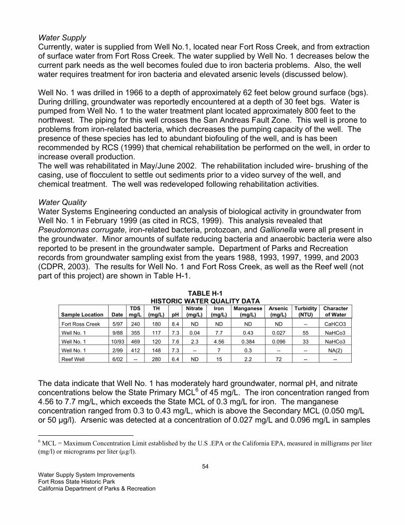
Water Supply System Improvements Fort Ross State Historic Park California Department of Parks & Recreation
54
Water Supply Currently, water is supplied from Well No.1, located near Fort Ross Creek, and from extraction of surface water from Fort Ross Creek. The water supplied by Well No. 1 decreases below the current park needs as the well becomes fouled due to iron bacteria problems. Also, the well water requires treatment for iron bacteria and elevated arsenic levels (discussed below). Well No. 1 was drilled in 1966 to a depth of approximately 62 feet below ground surface (bgs). During drilling, groundwater was reportedly encountered at a depth of 30 feet bgs. Water is pumped from Well No. 1 to the water treatment plant located approximately 800 feet to the northwest. The piping for this well crosses the San Andreas Fault Zone. This well is prone to problems from iron-related bacteria, which decreases the pumping capacity of the well. The presence of these species has led to abundant biofouling of the well, and is has been recommended by RCS (1999) that chemical rehabilitation be performed on the well, in order to increase overall production. The well was rehabilitated in May/June 2002. The rehabilitation included wire- brushing of the casing, use of flocculent to settle out sediments prior to a video survey of the well, and chemical treatment. The well was redeveloped following rehabilitation activities. Water Quality Water Systems Engineering conducted an analysis of biological activity in groundwater from Well No. 1 in February 1999 (as cited in RCS, 1999). This analysis revealed that Pseudomonas corrugate, iron-related bacteria, protozoan, and Gallionella were all present in the groundwater. Minor amounts of sulfate reducing bacteria and anaerobic bacteria were also reported to be present in the groundwater sample. Department of Parks and Recreation records from groundwater sampling exist from the years 1988, 1993, 1997, 1999, and 2003 (CDPR, 2003). The results for Well No. 1 and Fort Ross Creek, as well as the Reef well (not part of this project) are shown in Table H-1.
TABLE H-1 HISTORIC WATER QUALITY DATA
Sample Location Date TDS mg/L
TH (mg/L) pH
Nitrate (mg/L)
Iron (mg/L)
Manganese (mg/L)
Arsenic (mg/L)
Turbidity (NTU)
Character of Water
Fort Ross Creek 5/97 240 180 8.4 ND ND ND ND -- CaHCO3 Well No. 1 9/88 355 117 7.3 0.04 7.7 0.43 0.027 55 NaHCo3 Well No. 1 10/93 469 120 7.6 2.3 4.56 0.384 0.096 33 NaHCo3 Well No. 1 2/99 412 148 7.3 -- 7 0.3 -- -- NA(2) Reef Well 6/02 -- 280 6.4 ND 15 2.2 72 -- --
The data indicate that Well No. 1 has moderately hard groundwater, normal pH, and nitrate concentrations below the State Primary MCL6 of 45 mg/L. The iron concentration ranged from 4.56 to 7.7 mg/L, which exceeds the State MCL of 0.3 mg/L for iron. The manganese concentration ranged from 0.3 to 0.43 mg/L, which is above the Secondary MCL (0.050 mg/L or 50 µg/l). Arsenic was detected at a concentration of 0.027 mg/L and 0.096 mg/L in samples
6 MCL = Maximum Concentration Limit established by the U.S .EPA or the California EPA, measured in milligrams per liter (mg/l) or micrograms per liter (µg/l).

Water Supply System Improvements Fort Ross State Historic Park California Department of Parks & Recreation
55
taken from Well No. 1. The State Primary MCL for arsenic is 0.050 mg/L. The MCL for arsenic was lowered to 10 µg/l (0.010 mg/l) in January 2001 and water systems around the country must comply with this new level by January 23, 2006 (U. S. EPA, 2003). Collected groundwater samples were turbid. Corresponding iron and manganese concentrations appear to increase with higher turbidity. Therefore, it is likely that the high iron, manganese, and possibly arsenic concentration may be partly due to high turbidity. Groundwater may have high concentrations of iron and manganese due to underlying Franciscan Formation rocks, and proximity to the San Andreas Fault Zone (ESA, 2003). LESS THAN POTENTIALLY SIGNIFICANT LESS THAN SIGNIFICANT WITH SIGNIFICANT NO IMPACT MITIGATION IMPACT IMPACT WOULD THE PROJECT: a) Violate any water quality standards or waste discharge requirements?
b) Substantially deplete groundwater supplies or interfere substantially with groundwater recharge, such that there would be a net deficit in aquifer volume or a lowering of the local groundwater table level (e.g., the production rate of pre-existing nearby wells would drop to a level that would not support existing land uses or planned uses for which permits have been granted)?
c) Substantially alter the existing drainage pattern of the site or area, including through alteration of the course of a stream or river, in a manner which would result in substantial on- or off-site erosion or siltation?
d) Substantially alter the existing drainage pattern of the site or area, including through alteration of the course of a stream or river, or substantially increase the rate or amount of surface runoff in a manner which would result in on- or off-site flooding?
e) Create or contribute runoff water which would exceed the capacity of existing or planned stormwater drainage systems or provide substantial additional sources of polluted runoff?
f) Substantially degrade water quality?
g) Place housing within a 100-year flood hazard area, as mapped on a federal Flood Hazard Boundary or Flood Insurance Rate Map, or other flood hazard delineation map?

Water Supply System Improvements Fort Ross State Historic Park California Department of Parks & Recreation
56
LESS THAN POTENTIALLY SIGNIFICANT LESS THAN SIGNIFICANT WITH SIGNIFICANT NO IMPACT MITIGATION IMPACT IMPACT h) Place structures that would impede or redirect flood flows within a 100-year flood hazard area?
i) Expose people or structures to a significant risk of loss, injury, or death from flooding, including flooding resulting from the failure of a levee or dam?
j) Result in inundation by seiche, tsunami, or mudflow?
DISCUSSION (reference checklist responses)
a) During any planned grading, trenching, or excavation activities, a release of sediment to surface waters and ultimately to the ocean could occur. During construction of a new support structure for the above ground water line segment across Fort Ross Creek (second creek crossing), disturbance to the stream channel may occur. Other impacts to water quality could result from releases of fuels or other fluids from vehicles and equipment during the construction process. These activities could result in a violation of water quality standards and waste discharge requirements. Mitigation Measure HYDRO 1 would control releases of pollutants in storm (or other) water runoff. A plan to prevent; contain; and clean up any spills (Spill Prevention and Response Plan) would be used to mitigate for any impacts to water quality.
Mitigation Measure Hydro 1 – Water Quality� • Implementation of Mitigation Measure GEO 2 would provide BMPs to control erosion
and runoff during the project construction and post-construction. • Any measures required by the Department of Fish and Game as part of the
Streambed Alteration Agreement (1601 permit) for the planned rehabilitation of the above ground water line across Fort Ross Creek would be implemented.
• The project would comply with all applicable water quality standards as specified in the NCRWQCB Basin Plan.
• Implementation of Mitigation Measure HAZMAT 1 would mitigate for impacts to water quality from possible pollutants (fuels and other vehicle fluids) released from vehicles and heavy equipment during construction.
b) The project involves improvements to the storage and treatment of groundwater extracted
from Well No. 1. This project will not result in altering present levels of groundwater extraction. Currently, the amount of water extracted does not appear to deplete the aquifer or to interfere with the flow levels in Fort Ross Creek. Although no well log is available (showing aquifer zone(s) and characteristics), the well location on the bank of Fort Ross Creek implies that the groundwater is interconnected with the surface water in the creek. Any depletion of the aquifer or the creek flows would be reduced to less than significant by following Mitigation Measure HYDRO 2.

Water Supply System Improvements Fort Ross State Historic Park California Department of Parks & Recreation
57
Mitigation Measure Hydro 2– Water • State Parks would continue to consult with CDFG and follow the conditions of the
stream alteration agreement for water extracted from Fort Ross Creek. • The amount of water pumped would be determined by the water levels in the well and
the amount of drawdown to prevent over pumping. c) The existing drainages would not be altered in a manner that would significantly increase
on or off-site erosion or siltation. Implementation of Mitigation Measure HYDRO 1 above would reduce any siltation impacts to less than significant.
d) The drainage pattern would not be altered in a manner that would significantly increase the
rate or amount of surface runoff in a manner that would result in on- or off-site flooding. There would be no impact from this project.
e) This project would not create or contribute runoff water that would exceed the capacity of
existing or planned stormwater drainage systems. Provided soil erosion BMPs are followed and a Spill Prevention and Response Plan is in place, no substantial additional sources of polluted runoff would be expected from this project. Implementation of Mitigation Measures HYDRO 1 would reduce this impact to less than significant.
f) This project has the potential to substantially degrade water quality if BMPs to control soil
erosion and runoff or release of vehicle or equipment fluids were not in place during construction. Implementation of Mitigation Measure HYDRO 1 above would prevent a substantial degradation of water quality.
g) This project is not located within any FEMA-designated 100-year flood plain and does not
involve any housing. Therefore, there is no impact from this project. h) This project would not place structures that could impede or redirect flood flows within any
FEMA-designated 100-Year flood plain. Therefore, there is no impact from this project. i) The project would not expose people or structures to an increased significant risk of loss,
injury, or death from flooding, including flooding resulting from the failure of a levee or dam. Therefore, there is no impact from this project.
j) The project is not located in an area that would be inundated by either a seiche or a
tsunami. While landslides and possible mudflows have occurred in the steeper areas of Fort Ross SHP, no mudflows are expected to occur at the project site. No impact.

Water Supply System Improvements Fort Ross State Historic Park California Department of Parks & Recreation
58
THIS PAGE LEFT INTENTIONALLY BLANK

Water Supply System Improvements Fort Ross State Historic Park California Department of Parks & Recreation
59
IX. LAND USE AND PLANNING
ENVIRONMENTAL SETTING
Fort Ross SHP is located in the Sonoma Coast/Gualala sub-county planning region, which is zoned as a Public Facilities District (PF) in the Sonoma County General Plan. Properties with this zoning are considered to serve the community or public need; this status is intended to protect the property from encroachment of incompatible uses. This zoning is consistent with DPR’s classification of the property surrounding the historic Fort Ross stockade as a State Historic Park. Historical units are established primarily to preserve objects of historical, archaeological, and scientific interest, archaeological sites, and places commemorating important person or historic events (PRC 5019.59). The Sonoma Coast/Gualala Basin planning area runs the 40-mile length of the Pacific Coast margin from the Gualala River to the Estero Americano. In addition to several coastal communities, it extends inland to include Annapolis, Cazadero, Duncans Mills, Bodega, Freestone, Camp Meeker, and Occidental. Roughly paralleling The San Andreas Fault Zone, the rugged Sonoma Coast is a scenic area of regional, state, and national significance, with nearly vertical sea cliffs and sea stacks along the shoreline, dunes, marine terraces, coastal uplands, and headlands. In the north, the Gualala River South Fork extends inland into the coniferous forests of the western Mendocino Highlands. This planning area is also the most sparsely populated of the sub-county planning regions due to its relative remoteness and inaccessibility. County land use plans project 3,000 new residents for this area resulting in a population of 8,500. 2,780 jobs are expected, with the greatest gains associated with the recreation and tourism industries. However, development must be consistent with continued agricultural production, commercial fishing, timber, and management and maintenance of scenic landforms and viewsheds. Other than general maintenance, State Parks currently has no plans to further develop Fort Ross State Historic Park. All construction activities associated with this project would occur within the boundaries of Fort Ross State Historic Park. LESS THAN POTENTIALLY SIGNIFICANT LESS THAN SIGNIFICANT WITH SIGNIFICANT NO IMPACT MITIGATION IMPACT IMPACT WOULD THE PROJECT: a) Physically divide an established community?
b) Conflict with the applicable land use plan, policy, or regulation of any agency with jurisdiction over the project (including, but not limited to, a general plan, specific plan, local coastal program, or zoning ordinance) adopted for the purpose of avoiding or mitigating an environmental effect?
c) Conflict with any applicable habitat conservation plan or natural community conservation plan? DISCUSSION (reference checklist responses)
Water Supply System Improvements Fort Ross State Historic Park California Department of Parks & Recreation
60
a) The proposed project is within the Fort Ross SHP property. The project would add no barriers or elements that would divide or interfere with the established surrounding community. No impact.
b,c) As noted in the Environmental Setting and Discussion IX(a) above, the proposed project
site is located within Fort Ross SHP and is subject to land use restrictions contained in the Fort Ross SHP GP, and the Sonoma County GP. No project elements are in conflict with the zoning, regulatory policies, land use plans, conservation plans or ordinances for this area. All appropriate consultation and permits would be acquired, in compliance with all applicable local, state, and federal requirements. No impact.
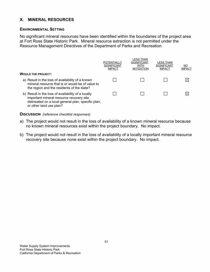
Water Supply System Improvements Fort Ross State Historic Park California Department of Parks & Recreation
61
X. MINERAL RESOURCES ENVIRONMENTAL SETTING
No significant mineral resources have been identified within the boundaries of the project area at Fort Ross State Historic Park. Mineral resource extraction is not permitted under the Resource Management Directives of the Department of Parks and Recreation. LESS THAN POTENTIALLY SIGNIFICANT LESS THAN SIGNIFICANT WITH SIGNIFICANT NO IMPACT MITIGATION IMPACT IMPACT WOULD THE PROJECT: a) Result in the loss of availability of a known mineral resource that is or would be of value to the region and the residents of the state?
b) Result in the loss of availability of a locally important mineral resource recovery site delineated on a local general plan, specific plan, or other land use plan? DISCUSSION (reference checklist responses)
a) The project would not result in the loss of availability of a known mineral resource because no known mineral resources exist within the project boundary. No impact.
b) The project would not result in the loss of availability of a locally important mineral resource
recovery site because none exist within the project boundary. No impact.

Water Supply System Improvements Fort Ross State Historic Park California Department of Parks & Recreation
62
THIS PAGE LEFT INTENTIONALLY BLANK

Water Supply System Improvements Fort Ross State Historic Park California Department of Parks & Recreation
63
XI. NOISE ENVIRONMENTAL SETTING
Fort Ross SHP, a 3,517-acre park, is located in a rural, sparsely populated are of Sonoma County with relatively low levels of traffic and little industrial noise, approximately 11 miles northwest of the town of Jenner. The park is bordered by State Highway 1; the Pacific Ocean rolling hills, coniferous forests and grazing lands. The project site is relatively undeveloped and no noise sensitive land uses are located in the immediate vicinity of any of the proposed construction. All construction activities associated with the project would occur within the park boundaries. LESS THAN POTENTIALLY SIGNIFICANT LESS THAN SIGNIFICANT WITH SIGNIFICANT NO IMPACT MITIGATION IMPACT IMPACT WOULD THE PROJECT: a) Generate or expose people to noise levels in excess of standards established in a local general plan or noise ordinance, or in other applicable local, state, or federal standards?
b) Generate or expose people to excessive groundborne vibrations or groundborne noise levels?
c) Create a substantial permanent increase in ambient noise levels in the vicinity of the project (above levels without the project)?
d) Create a substantial temporary or periodic increase in ambient noise levels in the vicinity of the project, in excess of noise levels existing without the project?
e) Be located within an airport land use plan or, where such a plan has not been adopted, within two miles of a public airport or public use airport? If so, would the project expose people residing or working in the project area to excessive noise levels?
f) Be in the vicinity of a private airstrip? If so, would the project expose people residing or working in the project area to excessive noise levels? DISCUSSION (reference checklist responses)
a) Construction noise levels at and near the project area would fluctuate, depending on the type and number of construction equipment operating at any given time, and would exceed ambient noise standards in the immediate vicinity of the work for brief periods of time. The distance from lodging accommodations and residences in the vicinity of the proposed work site is sufficient to prevent an objectionable level of noise. However, depending on the specific construction activities being performed, short-term increases in ambient noise levels could result in speech interference at the work site and a potential increase in annoyance to the closest visitors using the “Archy Camp” in the vicinity. As a result,

Water Supply System Improvements Fort Ross State Historic Park California Department of Parks & Recreation
64
construction-generated noise would be considered to have a potentially significant short-term impact. Implementation of the following mitigation measures would reduce those potential impacts to a less than significant level.
MITIGATION MEASURE NOISE 1 • Construction activities would generally be limited to the daylight hours, Monday -
Friday. If work during weekends or holidays is required, no work would occur on those days before 7:30 am or after 8 p.m.
• Internal combustion engines used for any purpose at the job site would be equipped with a muffler of a type recommended by the manufacturer. Equipment and trucks used for construction would utilize the best available noise control techniques (e.g., engine enclosures, acoustically-attenuating shields or shrouds, intake silencers, ducts, etc.) whenever feasible and necessary.
• Stationary noise sources and staging areas would be located as far from sensitive receptors as possible. If they must be located near sensitive receptors, stationary noise sources would be muffled to the extent feasible and/or, where practicable, enclosed within temporary sheds.
b) Construction activity would not involve the use of explosives; pile driving, or other intensive
construction techniques that could generate significant ground vibration or noise. Minor vibration immediately adjacent to excavating equipment would only be generated on a short-term basis. Therefore, groundborne vibration or noise generated by the project would have a less than significant impact.
c) Once the proposed project is completed, all related construction noise would disappear.
Nothing within the scope of the proposed project would result in a substantial permanent increases in ambient noise levels. Therefore, no impact.
d) See Discussion XI(a) above. Mitigated to a less than significant impact. e & f) This project is not located within an airport land use plan, within two miles of a public
airport, or in the vicinity of a private airstrip. No impact.

Water Supply System Improvements Fort Ross State Historic Park California Department of Parks & Recreation
65
XII. POPULATION AND HOUSING ENVIRONMENTAL SETTING
Fort Ross SHP, located in the Sonoma Coast/Gualala planning basin is the most sparsely populated of the nine planning regions in Sonoma County. In 1980, the 5,400 residents of this region mostly lived in various small villages; outside these small settlements, the population is limited. Housing within the park boundaries is limited to an intermittently used employee cabin near Call House. As a historic and recreational facility, the development of permanent housing is not a planned use of the park. LESS THAN POTENTIALLY SIGNIFICANT LESS THAN SIGNIFICANT WITH SIGNIFICANT NO IMPACT MITIGATION IMPACT IMPACT WOULD THE PROJECT: a) Induce substantial population growth in an area, either directly (for example, by proposing new homes and businesses) or indirectly (for example, through extension of roads or other infrastructure)? b) Displace substantial numbers of existing housing, necessitating the construction of replacement housing elsewhere? c) Displace substantial numbers of people, necessitating the construction of replacement housing elsewhere?
DISCUSSION (reference checklist responses)
a) Work proposed by this project would provide a water system that will solve the long-term water quality and supply problems at the park. The project would not have a housing component and all work would take place within the confines of the park boundaries. No new public or private projects are anticipated to be initiated as a result of the installation of the new water system. Therefore, it would have a less than significant impact on population growth in the area.
b) As noted in XII(a) Discussion above, the project would have no housing component and
would neither modify nor displace any existing housing. No houses would have to be moved or removed for the project. No impact.
c) As noted in XII(a) Discussion above, the project would have no housing component and
would displace no one, either temporarily or permanently. No impact.

Water Supply System Improvements Fort Ross State Historic Park California Department of Parks & Recreation
66
THIS PAGE LEFT INTENTIONALLY BLANK

Water Supply System Improvements Fort Ross State Historic Park California Department of Parks & Recreation
67
XIII. PUBLIC SERVICES ENVIRONMENTAL SETTING Fort Ross SHP is located 12 miles northwest of Jenner on Highway 1. The park sits on top of a scenic bluff. Within it's 3,517 acres, Fort Ross has redwood canyons, coastal bluffs, 4.23 miles of coastline, and a 90 acre underwater park. The park also contains several restored structures which are accessible to the public. Fire protection is provided by Sea Ranch CDF which is 22 miles from Fort Ross SHP. Also aiding in fire protection is Timber Cove Volinteer Fire Department, Sea Ranch Volunteer Fire Department, and Fort Ross Volunteer Fire Department. The State Park Rangers are trained in Law enforcement and are responsible for watching over the park. Other agencies in the area that respond to any problems are Sonoma County Sheriff's Department which is 39 miles away from the park. CHP also helps patrol the area. If there is a emergency which involves transportation, Reach (a helicopter flight service), Sonoma County Sheriff helicopter and Coastal Ambulance Service are close by to provide aid. Fort Ross Elementry is the closest school, only 7 miles away. There are two high schools which are 29 and 43 miles away, and an additional elementry school at a distance of 28 miles. There are no schools within the project site.
LESS THAN POTENTIALLY SIGNIFICANT LESS THAN SIGNIFICANT WITH SIGNIFICANT NO IMPACT MITIGATION IMPACT IMPACT WOULD THE PROJECT: a) Result in significant environmental impacts from construction associated with the provision of new or physically altered governmental facilities, or the need for new or physically altered governmental facilities, to maintain acceptable service ratios, response times, or other performance objectives for any of the public services:
Fire protection?
Police protection?
Schools?
Parks?
Other public facilities? DISCUSSION (reference checklist responses)
The proposed project would provide a reliable and safe water supply system for Fort Ross SHP. All facilities in the park would remain open during construction, although visitors may experience minor delays and detours along Highway 1. The project would not contribute to a increase of visitation and the level of required services is expected to remain the same. No impact.

Water Supply System Improvements Fort Ross State Historic Park California Department of Parks & Recreation
68
THIS PAGE LEFT INTENTIONALLY BLANK

Water Supply System Improvements Fort Ross State Historic Park California Department of Parks & Recreation
69
a) XIV. RECREATION ENVIRONMENTAL SETTING
Between 25,000 and 26,000 people visit Fort Ross SHP each year. The park offers visitors fishing, guided tours, hiking trails, primitive camping, scuba diving and a visitor's center. The park and surrounding area is also home to a variety of wildlife like the bobcat, gray fox, raccoon, black-tailed deer, brush rabbit, ground squirrel, pocket gopher, and broad handed moles. The weather at Fort Ross can be very nice. During the summer months the temperature ranges from the 60's to low 70's with a common marine layer. Winter months into the early spring can be very wet and fairly cold, with an average rainfall of 35 inches, and a temperature ranging from the high 50s to low 60's. Winter night temperatures generally drop into the low 40s. Fort Ross was established in 1812 to protect the Russian Fur Otter trade and grow food for their Alaskan outposts. The Russians left the fort in 1841 when the Sea Otters became scarce. Although none of the fort's original structures remain, several of the buildings have been reconstructed like the Commanders House, Russian Orthodox Chapel, the Rotchev House, the stockade and two blockhouses. LESS THAN POTENTIALLY SIGNIFICANT LESS THAN SIGNIFICANT WITH SIGNIFICANT NO IMPACT MITIGATION IMPACT IMPACT
WOULD THE PROJECT: a) Increase the use of existing neighborhood and regional parks or other recreational facilities, such that substantial physical deterioration of the facility would occur or be accelerated?
b) Include recreational facilities or require the construction or expansion of recreational facilities that might have an adverse physical effect on the environment? DISCUSSION (reference checklist responses)
a) No additional structures or attractions would be added as a result of this project that would increase visitation or demands to this or any other park or recreational facility in the area. No impact.
b) The proposed project does not contain any recreational facilities or require the
expansion of existing facilities. All facilities would remain open during construction. No impact.

Water Supply System Improvements Fort Ross State Historic Park California Department of Parks & Recreation
70
THIS PAGE LEFT INTENTIONALLY BLANK

Water Supply System Improvements Fort Ross State Historic Park California Department of Parks & Recreation
71
XV. TRANSPORATION/TRAFFIC ENVIRONMENTAL SETTING
The proposed project site is located within the boundaries of Fort Ross SHP, in the Sonoma Coast/Gualala Basin region. The region does not have an extensive highway network due to its remote location in the county and a very low population density. The major highways are State Route 1, Highway 116, Bodega Highway, and the Bohemian Highway, either two-lane or one-lane rural roadways. Daily buses connect the small communities along Highway 1 to Sebastopol and Santa Rosa. Traffic patterns in the region are affected primarily by recreational travel. Traffic volumes are the highest on Friday evenings in summer and from 3:00 – 7:00 p.m. on Sundays. Weekend travel delays occur south of Fort Ross SHP on Highway 1 from near Bodega to Jenner and Bodega Highway west of Sebastopol. Weekday traffic volumes are relatively low throughout the Sonoma Coast/Gualala Basin region. With proposed county design improvement projects on Highway 1, roadways are projected to function a Level of Service (LOS) “C”, stable traffic flow, but less freedom to select speed, change lanes or pass, or better on weekdays in 2005. LESS THAN POTENTIALLY SIGNIFICANT LESS THAN SIGNIFICANT WITH SIGNIFICANT NO IMPACT MITIGATION IMPACT IMPACT
WOULD THE PROJECT: a) Cause a substantial increase in traffic, in relation to existing traffic and the capacity of the street system (i.e., a substantial increase in either the number of vehicle trips, the volume to capacity ratio on roads, or congestion at intersections)?
b) Exceed, individually or cumulatively, the level of service standards established by the county congestion management agency for designated roads or highways?
c) Cause a change in air traffic patterns, including either an increase in traffic levels or a change in location, that results in substantial safety risks?
d) Contain a design feature (e.g., sharp curves or a dangerous intersection) or incompatible uses (e.g., farm equipment) that would substantially increase hazards?
e) Result in inadequate emergency access?
f) Result in inadequate parking capacity?
g) Conflict with adopted policies, plans, or programs supporting alternative transportation (e.g., bus turnouts, bicycle racks)?

Water Supply System Improvements Fort Ross State Historic Park California Department of Parks & Recreation
72
a)
DISCUSSION (reference checklist responses)
A significant increase in visitation to Fort Ross SHP is not anticipated as a result of the proposed project; work consists water system improvements designed to meet the needs of existing visitors, rather than the expansion of facilities to encourage increased usage. All construction activities associated with the project will occur within the boundaries of Fort Ross SHP and work would not restrict access to or block any public road. Although Hwy. 1 is the only access for construction equipment; the addition of several vehicles entering and leaving during daylight hours would not constitute a substantial increase in traffic volume or result in congestion at the park entrance intersection with Hwy. 1.
a) All construction activities associated with the project would occur within the boundaries of Fort Ross SHP. None of the activities proposed as part of this project would have the potential to cause traffic delays on a public road. Highway 1 would be the primary access road leading to the project site. The addition of an estimated 15-20 additional vehicles (crew pickups, delivery trucks, and equipment haulers) making 1-2 trips daily would not constitute a substantial increase in traffic volume for this road or result in additional congestion. Minimal delays may occur when construction vehicles arrive from the north and wait to turn left onto Old Fort Ross Road, but no more than with the regular daily traffic flow. In addition, work crews and equipment would typically arrive or leave the site outside the normal periods of congestion. Additionally, most heavy equipment would be stored on park property for the duration of the project, further reducing the traffic impacts. Therefore, the project would result in a less than significant impact. Less than significant impact.
b) As noted in the Environmental Setting above, Hwy. 1 is the primary access route for this
project location and generally operates at a level of service equivalent to an LOS-C (Caltrans LOS Definitions, 1989; SCGP Circulation Element, p294). As noted in Discussion XV(a) above, the limited number of construction-related vehicles visiting the site daily would not substantially increase traffic volume or congestion on Hwy. 1, in the vicinity of the project site. Less than significant impact.
c) The project site is not located within an airport land use plan, within two miles of a public
airport or in the vicinity of a private airstrip. Nothing in the proposed project would in any way affect or change existing air traffic patterns in the area. Therefore, no impact would occur as a result of this project.
d) No portion of the project design or implementation would alter existing traffic conditions or
add any element that would increase hazards to traffic or other forms of transportation. The project would improve the existing water system storage capacity and modify the existing alter treatment plant to treat the water to meet current Safe Drinking Water Act standards and guidelines. No impact.
e) All construction activities associated with the project would occur within the boundaries of
Fort Ross SHP and work would not restrict access to or block any public road. All areas within the park would remain open to the public during construction, except for a restricted area immediately adjacent to the project site. Minimum access requirements for emergency vehicles would be maintained at all times. Therefore, the impact of this project on emergency access or response would be less than significant.

Water Supply System Improvements Fort Ross State Historic Park California Department of Parks & Recreation
73
f) Adequate parking exists to accommodate current and projected levels of visitation.
Construction equipment and crew vehicles would occupy space at the existing treatment plant and new tank site; areas not open to the general public. Equipment would be stored at the existing treatment plant and the new tank site as well. Therefore, no impact.
g) There are no policies, plans, or programs supporting alternative transportation that apply to
this project. No impact.

Water Supply System Improvements Fort Ross State Historic Park California Department of Parks & Recreation
74
THIS PAGE LEFT INTENTIONALLY BLANK

Water Supply System Improvements Fort Ross State Historic Park California Department of Parks & Recreation
75
XVI. UTILITIES AND SERVICE SYSTEMS ENVIRONMENTAL SETTING
Located along Highway 1 and approximately 11 miles northwest of the town of Jenner, Fort Ross SHP is comprised of 3,386 acres, 4.23 miles of coastline, and a 90-acre underwater park. Water service to Fort Ross SHP is provided exclusively by a DPR-owned spring-fed pond and treatment facility within the park. The existing water supply system at Fort Ross includes existing water treatment building, well, evaporation pond (1.3 acre feet) and storage tanks. Sewage treatment is provided via an existing septic system. The Fort Ross SHP septic system consist of a leach field located south of the visitor center and on the west side of the “un-named “creek near the Call House. This field services the Call House, the visitor center and a small staff cabin. Inside the fort compound are two pit toilets (holding tanks) that are frequently pumped buy a private contractor. The final septic system, a leach field, is located at the Archy Camp and services the kitchen and the restrooms at the camp. Solid waste (refuse) is handled and transported by park staff to nearby county landfills; Pacific Gas and Electric supplies electricity; and Verizon provides phone service. LESS THAN POTENTIALLY SIGNIFICANT LESS THAN SIGNIFICANT WITH SIGNIFICANT NO IMPACT MITIGATION IMPACT IMPACT
WOULD THE PROJECT: a) Exceed wastewater treatment restrictions or standards of the applicable Regional Water Quality Control Board?
b) Require or result in the construction of new water Yes No or wastewater treatment facilities or expansion of existing facilities?
Would the construction of these facilities cause significant environmental effects?
c) Require or result in the construction of new storm Yes No water drainage facilities or expansion of existing facilities?
Would the construction of these facilities cause significant environmental effects?
d) Have sufficient water supplies available to serve the project from existing entitlements and resources or are new or expanded entitlements needed?
e) Result in a determination, by the wastewater treatment provider that serves or may serve the project, that it has adequate capacity to service the project’s anticipated demand, in addition to the provider’s

Water Supply System Improvements Fort Ross State Historic Park California Department of Parks & Recreation
76
existing commitments?
f) Be served by a landfill with sufficient permitted capacity to accommodate the project’s solid waste disposal needs?
g) Comply with federal, state, and local statutes and regulations as they relate to solid waste? DISCUSSION (reference checklist responses)
a) Fort Ross SHP is within the jurisdiction of the North Coast Regional Water Quality Control District (NCRWQCD). The project would be in compliance with all applicable water quality standards and waste discharge requirements. (See Mitigation Measures Bio-6, HAZMAT 1,and HAZMAT 2 regarding potential impacts from accidents, spills, or upset). No impact.
b) As noted in the Environmental Setting above, water for the park is supplied from DPR-
owned and/or controlled private water supplies. The proposed project would replace and modify existing water treatment facilities to comply with current standards and operational needs, not result in the expansion (only rehabilitation) of the existing internal plumbing or wastewater lines and would have no impact on public wastewater treatment facilities. Portable toilets would be provided at the job site and maintained in compliance with NCRWQCD requirements. Any changes in water usage would be minimal. Less than significant impact.
c) The project is limited to improvements to an existing water supply system, with little or no
change in existing drainage patterns. Installation of the new storage tank may require minimal regarding, but no new stormwater drainage facilities would be required. This project would not create or contribute to runoff water, which would exceed the capacity of existing or planned stormwater drainage systems. No impact.
d) As indicated in the Environmental Setting above, potable water is supplied for both the
construction site, and the park in general, from DPR-owned and/or controlled private water supplies. Current supplies are adequate for existing demands; the minimal additional demands associated with the proposed construction, and projected future use. Less than significant impact.
e, f) DPR personnel provide wastewater treatment services with DPR-owned facilities. The
proposed work would not increase the park’s wastewater or solid waste disposal needs, except as indicated in Discussion XVI(b) above. No impact.
g) This project would comply with all federal, state, and local statutes and regulations as they
relate to solid waste. No impact.
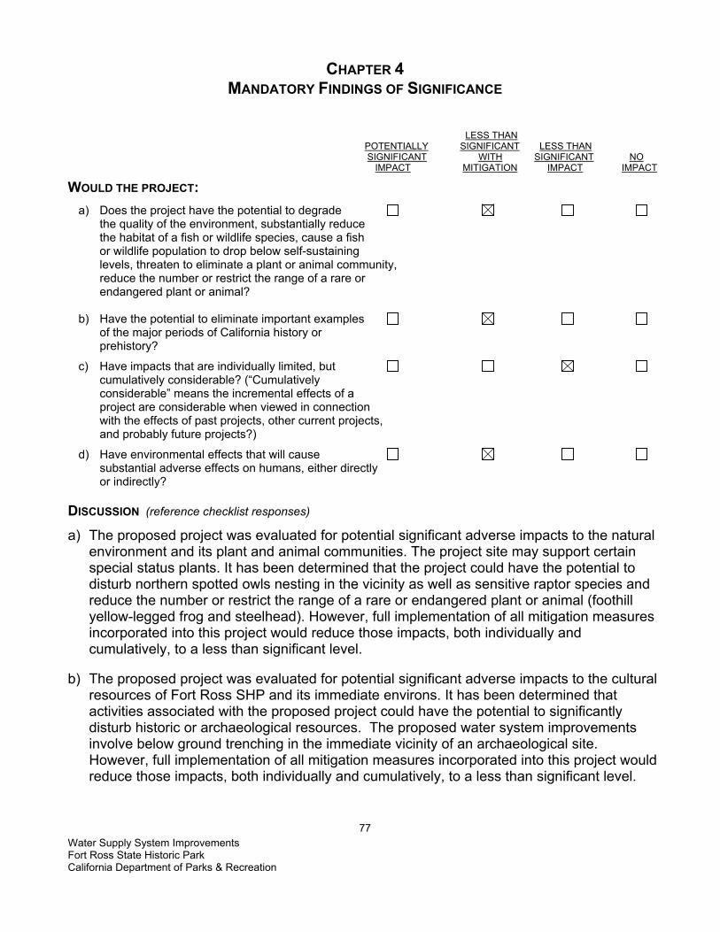
Water Supply System Improvements Fort Ross State Historic Park California Department of Parks & Recreation
77
CHAPTER 4 MANDATORY FINDINGS OF SIGNIFICANCE
LESS THAN POTENTIALLY SIGNIFICANT LESS THAN SIGNIFICANT WITH SIGNIFICANT NO IMPACT MITIGATION IMPACT IMPACT WOULD THE PROJECT: a) Does the project have the potential to degrade the quality of the environment, substantially reduce the habitat of a fish or wildlife species, cause a fish or wildlife population to drop below self-sustaining levels, threaten to eliminate a plant or animal community, reduce the number or restrict the range of a rare or endangered plant or animal? b) Have the potential to eliminate important examples of the major periods of California history or prehistory?
c) Have impacts that are individually limited, but cumulatively considerable? (“Cumulatively considerable” means the incremental effects of a project are considerable when viewed in connection with the effects of past projects, other current projects, and probably future projects?)
d) Have environmental effects that will cause substantial adverse effects on humans, either directly or indirectly? DISCUSSION (reference checklist responses)
a) The proposed project was evaluated for potential significant adverse impacts to the natural environment and its plant and animal communities. The project site may support certain special status plants. It has been determined that the project could have the potential to disturb northern spotted owls nesting in the vicinity as well as sensitive raptor species and reduce the number or restrict the range of a rare or endangered plant or animal (foothill yellow-legged frog and steelhead). However, full implementation of all mitigation measures incorporated into this project would reduce those impacts, both individually and cumulatively, to a less than significant level.
b) The proposed project was evaluated for potential significant adverse impacts to the cultural
resources of Fort Ross SHP and its immediate environs. It has been determined that activities associated with the proposed project could have the potential to significantly disturb historic or archaeological resources. The proposed water system improvements involve below ground trenching in the immediate vicinity of an archaeological site. However, full implementation of all mitigation measures incorporated into this project would reduce those impacts, both individually and cumulatively, to a less than significant level.
Water Supply System Improvements Fort Ross State Historic Park California Department of Parks & Recreation
78
c) DPR often has smaller maintenance programs and rehabilitation projects planned for a park unit. At Fort Ross SHP, this includes a reconstruction of the Old Magazin (Old Fur Warehouse) within the stockade. However, no other projects, other than routine maintenance, are planned for the proposed project area in the foreseeable future. Additionally, impacts from other environmental issues addressed in this evaluation do not overlap in such a way as to result in cumulative impacts that are greater than the sum of the parts. Less than significant impact.
d) Most project-related environmental effects have been determined to pose a less than
significant impact on humans. However, possible impacts from construction emissions (Air Quality), construction accidents, seismic events, and fire (Hazards and Hazardous Wastes), and noise, though temporary in nature, have the potential to result in significant adverse effects on humans. These potentially significant adverse impacts would be reduced to a less than significant level if all mitigation measures incorporated into this project were fully implemented.

CHAPTER 5 SUMMARY OF MITIGATION MEASURES
The following mitigation measures would be implemented by DPR as part of the Fort Ross State Historic Park Water Supply System Project. AIR QUALITY MITIGATION MEASURES AIR-1 • All active construction areas would be watered at least twice daily during dry, dusty
conditions. Any activities that cause visible dust plumes that cannot be controlled by watering would be suspended.
• All trucks hauling soil, sand, or other loose materials would be covered or required to maintain at least two feet of freeboard.
• All equipment engines would be maintained in good condition, in proper tune (according to manufacturer's specifications), and in compliance with all State and federal requirements.
• Excavation and grading activities would be suspended when sustained winds exceed 25 mph; instantaneous gusts exceed 35 mph. Sweep all access points to existing paved roads with water sweepers at completion of daily activities if visible soil material is deposited onto the adjoining roads.
• Disturbed areas would be re-vegetated as quickly as feasible following completion of construction.
• Earth or other material that has been transported by trucking or earth moving equipment, erosion by water, or other means onto paved streets would be promptly removed.
BIOLOGICAL RESOURCES MITIGATION MEASURES BIO-1 STEELHEAD AND FOOTHILL YELLOW-LEGGED FROG California Department of Fish and Game and National Marine Fisheries (NMFS) would
be consulted to ensure that BMPs are sufficient to protect sensitive fish and frog species.
• Creek crossing during spring steelhead river entry and spawning (January to June) would be restricted in accordance with measures recommended by NMFS and DFG. If seasonal avoidance were not possible, a temporary creek crossing would be installed, or a biological monitor would be present during the times that project-related vehicles would be crossing Fort Ross Creek to watch for fish and frogs crossing in the creed area. If a fish or frog is seen in the crossing area, vehicles would be prohibited form crossing the creek until the animal moves at least 50 feet up or down stream from the road crossing. A DPR-approved resource ecologist would conduct a training session for all project
personnel prior to the start of construction. Instruction would cover identification of sensitive species and their habitat, and specific measures required to protect and avoid sensitive wildlife. Training would address general conservation measures, proper disposal and covering of trash and construction debris, and response to fluid
Water Supply System Improvements Fort Ross State Historic Park California Department of Parks & Recreation
79
spills. The training would be completed prior to authorizing personnel to work in the project area.
• All open trenches would be covered or escape boards placed within the trenches at the end of each workday. A DPR-qualified resource ecologist would monitor trenches when filled in.
• Best Management Practices (BMPs) would be implemented during construction to prevent any construction debris or sediment from leaving the project area and impacting adjacent habitat. Refer to Mitigation Measures GEO 2 Erosion Control, HYDRO 1 Water Quality, and HYDRO 2 Water.
MITIGATION MEASURES BIO-2 NORTHERN SPOTTED OWL SEASONAL AVOIDANCE • Construction activities would not occur during the breeding season for the northern spotted
owl (February 1st – August 31st). The specific dates of the breeding season closure period could be adjusted through consultations with USFWS based on the characteristics of the local population.
MITIGATION MEASURES BIO-3 CNPS LIST 1B PLANT SPECIES • Surveys would be conducted during the appropriate blooming months (or when species
can be unmistakably identified) for all CNPS List 1B and List 2 plant species that could potentially occur within the project area.
• All occurrences of CNPS List 1B and List 2 species found within the project area would be mapped on project maps, flagged on the ground, and avoided if possible.
• If significant unavoidable impacts would occur to CNPS List 1B or List 2 species as a result of project implementation, DPR would mitigate losses of habitat or individuals at a ratio of 3:1 through habitat enhancement for these species within the Fort Ross State Historic Park (or as negotiated with the California Department of Fish and Game).
MITIGATION MEASURE BIO- 4 SENSITIVE NATURAL COMMUNITIES • Within the structural root zone of any native tree with a dbh (diameter at breast height) of
24 inches or greater, no roots with a diameter of 1 inch or greater would be cut by trenching activities. In these areas, it would be permissible to tunnel under the structural root zone at a depth equal to or greater than 3 feet. It would also permissible to remove soil by hand form roots that are larger than 1 inch in diameter.
CULTURAL RESOURCES MITIGATION MEASURES CULT-1 • The project's APE would be surface surveyed with periodic surface scrapes in areas
where ground visibility is poor. The survey would occur prior to the start of construction and ground disturbance. If previously unrecorded sites are located during the survey, the project would be modified, in consultation with the DPR cultural specialist to avoid impacts to the site(s) or reduce potential impacts to a less than significant level.
MITIGATION MEASURE CULT-2
Water Supply System Improvements Fort Ross State Historic Park California Department of Parks & Recreation
80
• Prior to any below ground trenching, an Archaeologist that meets the Secretary of Interior’s minimum qualification standards in historic archaeology would dig shovel test
units along the proposed (new) tank siting and linear transects of the water line. If any cultural materials were discovered, the location of the tank site and pipe connections would be adjusted to avoid disturbing the sites. If there were no way to avoid impacting the site, then the site would be fully recorded and tested for significance prior to the excavation. Archaeological monitoring would occur during all ground disturbing activities.
MITIGATION MEASURE CULT-3 • In the event that human remains are discovered, work would cease immediately in the
area of the find and the project manager/site supervisor would notify the appropriate DPR personnel. Any human remains and/or funerary objects would be left in place or returned to the point of discovery and covered with soil. The DPR Sector Superintendent (or authorized representative) would notify the County Coroner, in accordance with §7050.5 of the California Health and Safety Code, and the Native American Heritage Commission (or Tribal Representative). If a Native American monitor is on-site at the time of the discovery, the monitor would be responsible for notifying the appropriate Native American authorities.
The local County Coroner should make the determination of whether the human bone is of Native American origin. In many of California's historic townsites and rural communities discoveries have been made of non-Native American human bone including non-Anglo. If the coroner or tribal representative determines the remains represent Native American interment, the NAHC in Sacramento and/or tribe would be consulted to identify the most likely descendants and appropriate disposition of the remains. Work would not resume in the area of the find until proper disposition is complete (PRC §5097.98). No human remains or funerary objects would be cleaned, photographed, analyzed, or removed from the site prior to determination If it is determined the find indicates a sacred or religious site, the site would be avoided to the maximum extent practicable. Formal consultation with the State Historic Preservation Office and review by the Native American Heritage Commission/Tribal Cultural representatives would occur as necessary to define additional site mitigation or future restrictions.
GEOLOGY AND SOILS MITIGATION MEASURES GEO-1 SEISMIC BUILDING REQUIREMENTS • The proposed water tank must conform to earthquake design requirements. Tank and
foundation design would follow the applicable regulations and design practices of the American Water Works Association Design Standards.
• Any new equipment installed as part of the water system treatment upgrades would be secured to the walls and/or floor in the existing water treatment building to prevent damage in the event of a large earthquake.
MITIGATION MEASURE GEO 2 EROSION CONTROL Water Supply System Improvements Fort Ross State Historic Park California Department of Parks & Recreation
81

• BMPs would be used in all areas to control soil and surface water runoff during excavation, grading, and trenching. Grading and excavation activities would not be planned during the rainy season (October 31 to May 1), but if storms are anticipated during construction or if construction must occur during winter months, “winterizing” would occur, including the covering (tarping) of any stockpiled soils and the use of temporary erosion control methods to protect disturbed soil. Temporary erosion control measures (BMPs) must be used during all soil disturbing activities and until all disturbed soil has been stabilized (re-compacted, re-vegetated, etc.) These BMPs would include, but not be limited to, the use of silt fences, straw bales, or straw or rice coir rolls, to prevent soil loss and siltation into nearby water bodies.
• Permanent BMPs for erosion control would consist of properly compacting disturbed areas and re-vegetation of appropriate disturbed soil areas with native species using seed collected locally. Final design plans would incorporate BMP measures to be incorporated into the project.
• The project would meet or exceed all applicable local building and engineering regulations/ordinances required by Sonoma County.
MITIGATION MEASURE GEO 3 ENGINEERING DESIGN FOR EXPANSIVE SOILS • Engineering designs would be incorporated to provide a water tank foundation that is
compatible with expansive or corrosive soils. HAZARDS AND HAZARDOUS MATERIALS MITIGATION MEASURES HAZMAT-1 SPILL PREVENTION • All equipment would be inspected for leaks immediately prior to the start of construction,
and regularly inspected thereafter until equipment is removed from park premises. • The contractor(s) and/or DPR would prepare an emergency Spill Prevention and
Response Plan prior to the start of construction and maintain a spill kit on-site throughout the life of the project. This plan would include a map that delineates construction staging areas, where refueling, lubrication, and maintenance of equipment may occur. In the event of any spill or release of any chemical in any physical form at the project site or within the boundaries of Fort Ross SHP during construction, the contractor would immediately notify the appropriate DPR staff (e.g., project manager, supervisor, or State Representative).
• Equipment would be cleaned and repaired (other than emergency repairs) outside the park boundaries. All contaminated water, sludge, spill residue, or other hazardous compounds would be disposed of outside park boundaries, at a lawfully permitted or authorized destination.
MITIGATION MEASURE HAZMAT- 2 CONSTRUCTION FIRE MANAGEMENT • A fire safety plan would be developed by the contractor and approved by DPR prior to the
start of construction. • Spark arrestors or turbo-charging (which eliminates sparks in exhaust) and fire
extinguishers would be required for all heavy equipment.
Water Supply System Improvements Fort Ross State Historic Park California Department of Parks & Recreation
82

• Construction crews would be required to park vehicles away from flammable material, such as dry grass or brush. At the end of each workday, heavy equipment would be parked over mineral soil, asphalt, or concrete to reduce the chance of fire.
• Park staff would be required to have a State Park radio on site, which allows direct contact to California Department of Forestry and Fire Protection (CDF) and centralized dispatch center, to facilitate the rapid dispatch of control crews and equipment in case of a fire.
• Fire suppression equipment would also be available and located on park grounds. HYDROLOGY AND WATER QUALITY MITIGATION MEASURE HYDRO 1 WATER QUALITY • Implementation of Mitigation Measure GEO 2 would provide BMPs to control erosion and
runoff during the project construction and post-construction. • Any measures required by the Department of Fish and Game as part of the Streambed
Alteration Agreement (1601 permit) for the planned rehabilitation of the above ground water line across Fort Ross Creek would be implemented.
• The project would comply with all applicable water quality standards as specified in the NCRWQCB Basin Plan.
• Implementation of Mitigation Measure HAZMAT 1 would mitigate for impacts to water quality from possible pollutants (fuels and other vehicle fluids) released from vehicles and heavy equipment during construction.
MITIGATION MEASURE HYDRO 2– WATER • State Parks will continue to consult with CDFG and follow the conditions of the stream
alteration agreement for water extracted from Fort Ross Creek. • The amount of water pumped will be determined by the water levels in the well and the
amount of drawdown to prevent over pumping. NOISE MITIGATION MEASURES NOISE-1 • Construction activities would generally be limited to the daylight hours, Monday - Friday. If
work during weekends or holidays is required, no work would occur on those days before 7:30 am or after 8 p.m.
• Internal combustion engines used for any purpose at the job site would be equipped with a muffler of a type recommended by the manufacturer. Equipment and trucks used for construction would utilize the best available noise control techniques (e.g., engine enclosures, acoustically-attenuating shields or shrouds, intake silencers, ducts, etc.) whenever feasible and necessary.
• Stationary noise sources and staging areas would be located as far from sensitive receptors as possible. If they must be located near sensitive receptors, stationary noise sources would be muffled to the extent feasible and/or, where practicable, enclosed within temporary sheds.
Water Supply System Improvements Fort Ross State Historic Park California Department of Parks & Recreation
83

THIS PAGE LEFT INTENTIONALLY BLANK
Water Supply System Improvements Fort Ross State Historic Park California Department of Parks & Recreation
84

CHAPTER 6 REFERENCES
Aesthetics Section Parks and Recreation in Sonoma County Internet site. Website address: http://www.parks.sonoma.net/fortross.html Bell, Daniel A., Monica Aleman, Daniel Osanna. Cultural Resource Inventory of the Call Sheep Ranch and Pedotti Barn Site, Fort Ross State Historic Park. Sonoma County, California. 2003, Northern Service Center, California State Parks. Agriculture Section Brendan O’Neil, Resource Ecologist. Personal communication. 2003 Heidi Horvitz, Head Ranger. Personal communication. 2003 Air Quality Section Maps and Tables of the Area Designations for the State and National Ambient Air Quality Standards, Chapter 3. Retrieved December 2, 2003 from http://www.arb.ca.gov/desig/desig02/desig02pubrepch3.doc California Air Resources Board , State Area Designations Definitions. Retrieved December 2, 2003 from: http://www.arb.ca.gov/desig/adm/Define.htm
California Department of Parks and Recreation, Fort Ross General Development Plan, November 1975 Parks and Recreation in Sonoma County Internet site. Website address: http://www.parks.sonoma.net/fortross.html Fort Ross State Historic Park Russian Colony, Web Address: http://www.mcn.org/1/rrparks/fortross/ Bio Section California Department of Fish and Game (CDFG). 2003. California Natural Diversity Database. Sacramento, CA. California Native Plant Society (CNPS). 2001. Inventory of Rare and Endangered Plants of California, 6th edition, electronic version. Jennings, Mark R., and Marc P. Hayes. 1994. Amphibian and Reptile Species of Special Concern in California. California Department of Fish and Game Inland Fisheries Division. Rancho Cordova, CA. 255 pp.
Water Supply System Improvements Fort Ross State Historic Park California Department of Parks & Recreation
85

Mad River Biologists. 2003. Final Report for 2003 Field Season – Marbled Murrelet and Spotted Owl Surveys at Fort Ross State Historic Park. McKinleyville, CA. 9 pp. Sawyer, J. and T. Keeler-Wolf. 1995. A Manual of California Vegetation. California Native Plant Society. 471 pp. Zeiner, David C., William F. Laudenslayer, Kenneth E. Mayer, and Marshall White. California’s Wildlife – Volume I – Amphibians and Reptiles. California Department of Fish and Game. Sacramento, CA. 272 pp. Zeiner, David C., William F. Laudenslayer, Kenneth E. Mayer, and Marshall White. 1990. California’s Wildlife – Volume II – Birds. California Department of Fish and Game. Sacramento, CA. 732 pp. Cultural Section Birnbaum, Charles A., 1994 Protecting Cultural Landscapes: Planning, Treatment and Management of Historic Landscapes, Preservation Brief 36, National Park Service, Washington D.C. California Department of Parks and Recreation, Fort Ross State Historic Park. Resource 1975 Management Plan and General Development Plan. Farris, Glenn J., 1989 The Russian Imprint on the Colonization of California. In: Columbian Consequences I: Archaeological and Historical Perspectives on the Spanish Borderlands West, David Hurst Thomas (ed.), pp. 481-497. Washington: Smithsonian Institution.
1991 A New Focus at Fort Ross: The Alaskan Native Peoples in California. Society for California Archaeology Newsletter 25 (1):4-5. 1991 Life in the Sloboda: A View of the Village at Fort Ross. California. Paper read at the Annual Meetings of the Society for Historical Archaeology, January, Kansas City. Fredrickson, David, Early cultures of the North Coast Ranges, California. Ph.D. dissertation. Davis: Department of Anthropology, University of California. 1974 A Cultural diversity in early central California: A view from the North Coast Ranges. The Journal of California Anthropology 1 (1):41-54. Kniffen, F.B., 1939 Pomo geography. Berkeley. University of California Publications in American Archaeology and Ethnology 36 (6): 353-400. Lightfoot, Kent G., Thomas A. Wake, and Ann M. Schiff 1991 The Archaeology and Ethnohistory of Fort Ross, California. Vol. 1 Introduction Archaeology Research Facility. Univesity of California at Berkeley. Water Supply System Improvements Fort Ross State Historic Park California Department of Parks & Recreation
86

Kroeber, A.L. 1925 Handbook of the Indians of California. Dover Publications, Inc. Moratto, Michael, 1984 California Archaeology. Academic Press, Inc. Myers, Jim , Associate Civil Engineer. Personal Communication. Northern Service Center, Department of Parks and Recreation, Sacramento. 2003 Thompson, Thos. H. and Company 1877 New Historical Atlas of Sonoma County. Illustrated. Oakland, Ca. Watrous, Stephen, Fort Ross. The Russian Settlement in California. Published by the Fort Ross Interpretive Association. United States Coast Survey Map of Fort Ross Region. On file at Bancroft Library, U.C. Berkeley. Geology and Soils ESA (Environmental Science Associates), 2003, Fort Ross State Historic Park, Fiberboard Property Improvement Project, Geology and Hydrology Resource Inventory and Report, prepared for California Department of Parks and Recreation. Huffman, M.E., 1972, Geology for Planning on the Sonoma County Coast between the Russian and Gualala Rivers, Preliminary Report. Prepared for California Department of Conservation, Division of Mines and Geology in Cooperation with the Sonoma County Planning Department. Petersen, M. D., Bryant, W. A., Cramer, C. H., Cao, T., Reichle, M.S., Frankel, A. D., Lienkaemper, J. J., McCrory, P. A., and Schwartz, D. P., 1996, Probabilistic Seismic Hazard Assessment for the State of California, Division of Mines and Geology Open File Report 96-08; fault parameters on-line at: http://www.consrv.ca.gov/cgs/rghm/psha/ofr9608/ Petersen, M., Beeby, D., Bryant, W., Cao, C., Cramer, C., Davis, J., Reichle, M., Saucedo, G., Tan, S., Taylor, G., Toppozada, T., Treiman, J., Wills, C., 1999, Seismic Shaking Hazard Maps of California, Map Sheet 48. USDA (US Department of Agriculture), 1972, Soil Survey for Sonoma County, California, Hazards and Hazardous Materials Severn Trent Services, 2003, SORB 33 Features, website: http://www.severntrentservices.com Hydrology and Water Quality ESA (Environmental Science Associates), 2003, Fort Ross State Historic Park, Fiberboard Property Improvement Project, Geology and Hydrology Resource Inventory and Report, prepared for California Department of Parks and Recreation. Water Supply System Improvements Fort Ross State Historic Park California Department of Parks & Recreation
87
North Coast Regional Water Quality Control Board, 1993, Water Quality Control Plan for the North Coast Region, website address: http://www.swrcb.ca.gov/rwqcb1/down/032202basin-plan.pdf Richard C. Slade & Associates LLC (RCS), 1999, Hydrogeologic Evaluation and Well Siting Study for the Fort Ross State Historic Park, Sonoma County, California, prepared for California State Parks. U. S. EPA, 2003, Groundwater and Drinking Water, Arsenic in Drinking Water, website: http://www.epa.gov/safewater/arsenic.html Land Use and Planning Sonoma County General Plan 1989. Retrieved December 9, 2003 from http://www.sonoma-county.org/prmd/gp2020/1998/index.html. Mineral Resources Noise Sonoma County General Plan 1989. Retrieved December 9, 2003 from http://www.sonoma-county.org/prmd/gp2020/1998/index.html. Population and Housing Sonoma County General Plan 1989. Retrieved December 9, 2003 from http://www.sonoma-county.org/prmd/gp2020/1998/index.html. Roy McNamee, Supervising Ranger. Personal communication. 2003 Public Services Joy, Robin "Re info for MND" E-mail to Andrew Pillado. 21 October 2003. Fort Ross SHP Internet Search. Retrieved October 15, 2003. Website address: http://www.parks.ca.gov/. Fort Ross State Historic Park Russian Colony. Retrieved October 20, 2003. Website address: http://www.mcn.org/1/rrparks/fortross/parkinfo.htm. Parks and Recreation in Sonoma County Internet site. Retrieved November 10, 2003. Website address: http://parks.sonoma.net/fortross.html Recreation Joy, Robin "Re info for MND" E-mail to Andrew Pillado. 21 October 2003. Fort Ross SHP Internet Search. Retrieved October 15, 2003. Website Address: http://www.parks.ca.gov/.
Water Supply System Improvements Fort Ross State Historic Park California Department of Parks & Recreation
88
Fort Ross State Historic Park Russian Colony. Retrieved October 20, 2003. Website address: http://www.mcn.org/1/rrparks/fortross/parkinfo.htm. Parks and Recreation in Sonoma County Internet site. Retrieved November 10, 2003. Website address: http://parks.sonoma.net/fortross.html. Transportation/Traffic California Department of Transportation (CalTrans). Retrieved December 9, 2003. Website address: http://www.dot.ca.gov. Utilities and Service Systems Roy McNamee Park Maintenance Chief III. Personal Communication. Northern Service Center, Department of Parks and Recreation, Sacramento. 2003
Water Supply System Improvements Fort Ross State Historic Park California Department of Parks & Recreation
89

THIS PAGE LEFT INTENTIONALLY BLANK
Water Supply System Improvements Fort Ross State Historic Park California Department of Parks & Recreation
90
CHAPTER 7 REPORT PREPARATION
California Department of Parks and Recreation Northern Service Center Sacramento, California Roy Martin Associate Resource Ecologist Jim Myers Civil Engineering Associate Dan Osanna State Historian III Blythe Wilson Student Intern Patti DuMont Environmental Coordinator Kathleen Considine Associate Engineering Geologist Ray Benson Associate State Archaeologist Jim Trapani Senior Landscape Architect Monica Aleman State Historian II Cyndy Shafer Associate Resource Ecologist
Water Supply System Improvements Fort Ross State Historic Park California Department of Parks & Recreation
91

THIS PAGE LEFT INTENTIONALLY BLANK
Water Supply System Improvements Fort Ross State Historic Park California Department of Parks & Recreation
92

APPENDIX A
MAPS, TABLES, AND CHARTS ____________________________________
Water Supply System Improvements Fort Ross State Historic Park California Department of Parks & Recreation
93

THIS PAGE LEFT INTENTIONALLY BLANK
Water Supply System Improvements Fort Ross State Historic Park California Department of Parks & Recreation
94
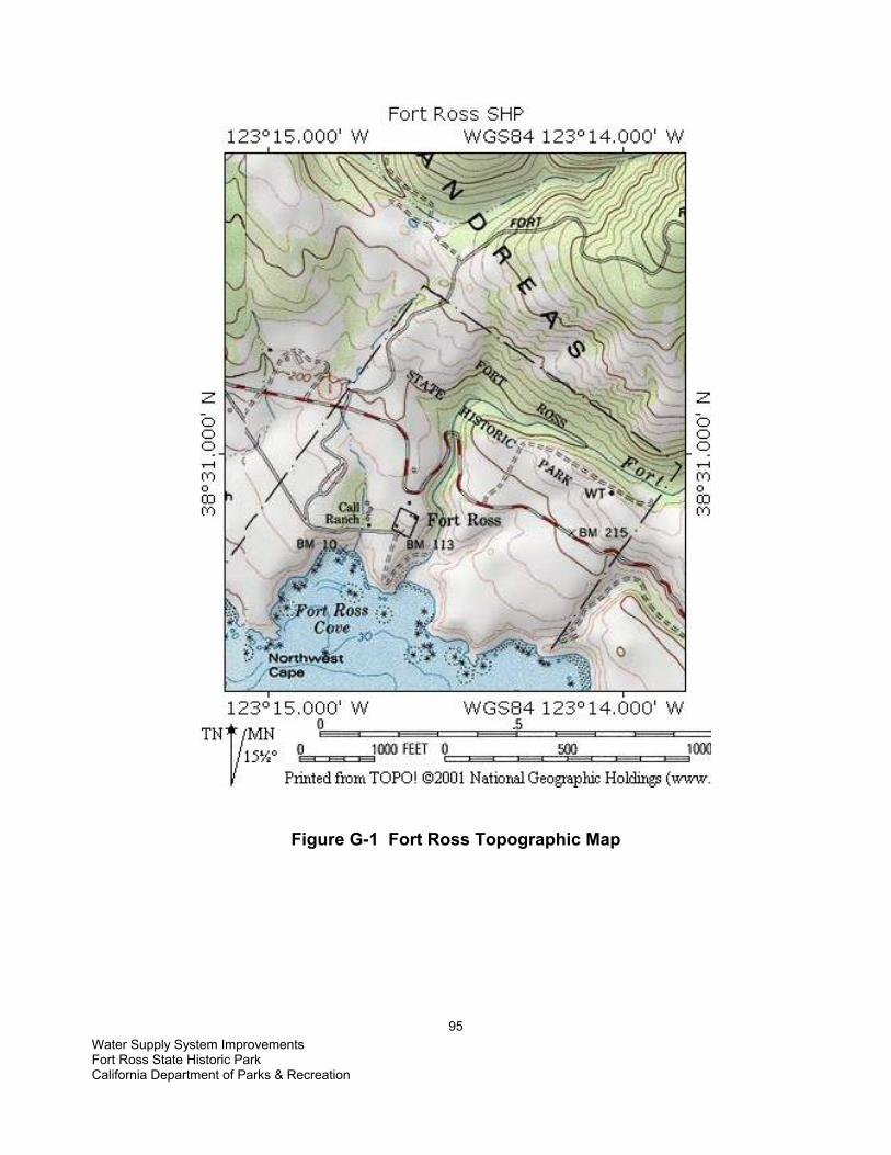
Figure G-1 Fort Ross Topographic Map
Water Supply System Improvements Fort Ross State Historic Park California Department of Parks & Recreation
95

from ESA, 2003
Figure G-3 Geologic Time Scale
Water Supply System Improvements Fort Ross State Historic Park California Department of Parks & Recreation
96

from ESA, 2003
Figure G-3 Geology Map
(See legend next page)
Water Supply System Improvements Fort Ross State Historic Park California Department of Parks & Recreation
97

from ESA, 2003
Figure G-3 Legend
Water Supply System Improvements Fort Ross State Historic Park California Department of Parks & Recreation
98

from ESA, 2003
Figure G-4 Slope Stability
(see legend next page)
Water Supply System Improvements Fort Ross State Historic Park California Department of Parks & Recreation
99
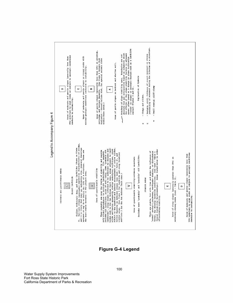
Figure G-4 Legend
Water Supply System Improvements Fort Ross State Historic Park California Department of Parks & Recreation
100

Figure G-5 Alquist-Priolo Earthquake Fault Zone APEFZ boundary outlined in yellow
Water Supply System Improvements Fort Ross State Historic Park California Department of Parks & Recreation
101

Water Supply System Improvements Fort Ross State Historic Park California Department of Parks & Recreation
102
Figure H-1 Fort Ross Watersheds

Water Supply System Improvements Fort Ross State Historic Park California Department of Parks & Recreation
103
APPENDIX B
PROJECT DESIGN GRAPHICS
Water Supply System Improvements Fort Ross State Historic Park California Department of Parks & Recreation
104
THIS PAGE LEFT INTENTIONALLY BLANK

Water Supply System Improvements Fort Ross State Historic Park California Department of Parks & Recreation
105

Water Supply System Improvements Fort Ross State Historic Park California Department of Parks & Recreation
106
THIS PAGE LEFT INTENTIONALLY BLANK

Water Supply System Improvements Fort Ross State Historic Park California Department of Parks & Recreation
107
APPENDIX C
ACRONYMS ______________________________________

Water Supply System Improvements Fort Ross State Historic Park California Department of Parks & Recreation
108
THIS PAGE LEFT INTENTIONALLY BLANK

Water Supply System Improvements Fort Ross State Historic Park California Department of Parks & Recreation
109
APPENDIX C LIST OF ACRONYMS
AAQS Ambient Air Quality Standards ASL above sea level APE Area of Potential Effect AWWA American Water Works Association BMP Best Management Practice Cal OSHA California Occupational Safety and health Agency Cal Trans California Department of Transportation CARB California Air Resources Board CCR California Code of Regulations CDF California Department of Forestry and Fire Protection CEQA California Environmental Quality Act CNDDB California Natural Diversity Database CNPS California Native Plant Society DFG California Department of Fish and Game DOT Department of Transportation DPR California Department of Parks and Recreation EIR Environmental Impact Report FEMA Federal Emergency Management Agency FMMP Farmland Mapping and Monitoring Program GP General Plan IRB Iron-related bacteria IS/MND Initial Study/Mitigated negative Declaration LOS Level of Use msl median sea level NAHC Native American Heritage Commission NCAB North Coast Air Basin NCRWQCD North Coast Regional Water Quality Control District NMFS National Marine Fisheries Service NSCAPCD Northern Sonoma County Air Pollution Control District NOx Nitrogen Oxide NRHP National Register of Historic Places PRC Public Resources Code PM10 Particulate Matter with an aerodynamic diameter of 10 microns or less ROG reactive organic gases RWQCD Regional Water Quality Control District SHP State Historic Park SHPO State Historic Preservation Office TCLP Toxicity Characteristic Leaching Procedure USACE United States Army Corps of Engineers USEPA United States Environmental Protection Agency USFWS United States Fish and Wildlife Service USGS United States Geologic Society VRP visibility-reducing particles