ino: rantau dedap geothermal power project · muara enim regency and pagar alam city, south sumatra...
TRANSCRIPT
Environmental and Social Impact Assessment Report (ESIA) – Appendix 9
Project Number: 50330-001 February 2018
INO: Rantau Dedap Geothermal Power Project
(Phase 2)
Prepared by PT Supreme Energy Rantau Dedap (PT SERD) for Asian Development Bank The environmental and social impact assessment is a document of the project sponsor. The views expressed herein do not necessarily represent those of ADB’s Board of Directors, Management, or staff, and may be preliminary in nature. Your attention is directed to the “Terms of Use” section of this website. In preparing any country program or strategy, financing any project, or by making any designation of or reference to a particular territory or geographic area in this document, the Asian Development Bank does not intend to make any judgments as to the legal or other status of or any territory or area.
Greencap
Intiland Tower | 18th
Floor
Jl. Jend. Sudirman Kav. 32
Jakarta 10220
Indonesia
P: +62 21 5790 1344
F: +62 21 5790 1348
www.greencap.com.au
FINAL REPORT OF
STUDY OF ENDANGERED SPECIES AT
RANTAU DEDAP
PT SUPREME ENERGY RANTAU DEDAP (SERD)
Muara Enim Regency and Pagar Alam City,
South Sumatra Province
12 February 15
JI100114
March 2015
STUDY OF ENDANGERED SPECIES AT RANTAU DEDAP i
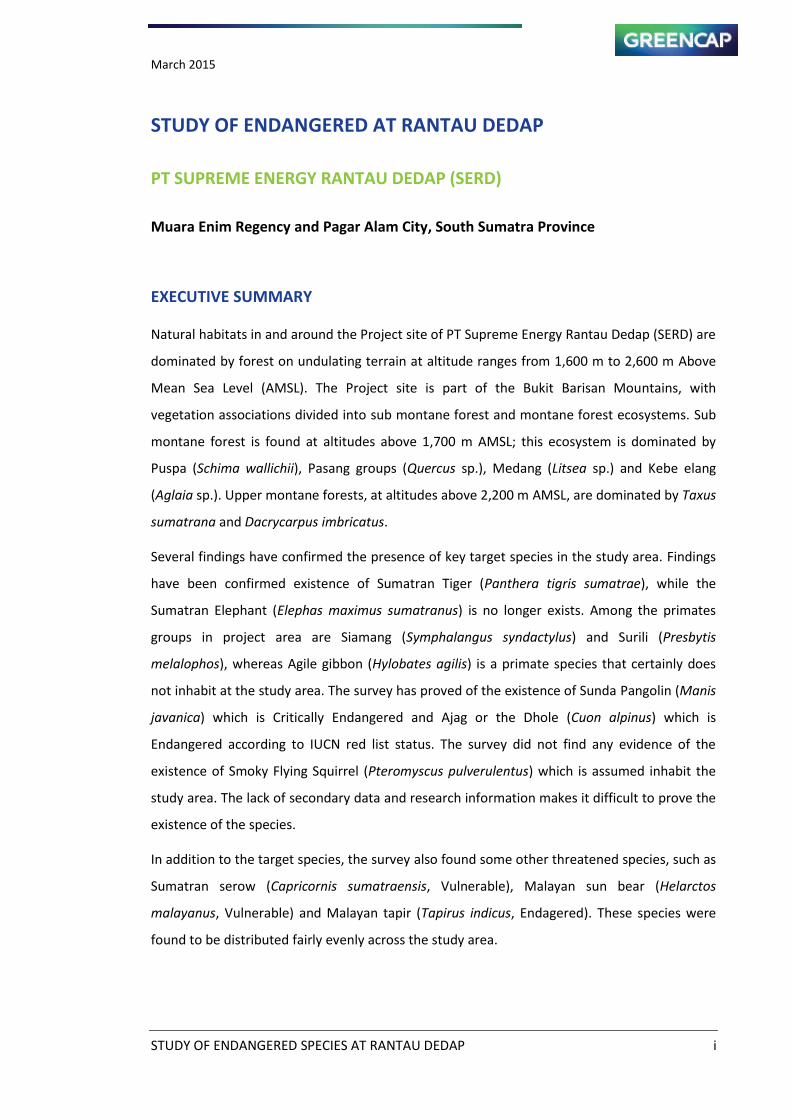
STUDY OF ENDANGERED AT RANTAU DEDAP
PT SUPREME ENERGY RANTAU DEDAP (SERD)
Muara Enim Regency and Pagar Alam City, South Sumatra Province
EXECUTIVE SUMMARY
Natural habitats in and around the Project site of PT Supreme Energy Rantau Dedap (SERD) are
dominated by forest on undulating terrain at altitude ranges from 1,600 m to 2,600 m Above
Mean Sea Level (AMSL). The Project site is part of the Bukit Barisan Mountains, with
vegetation associations divided into sub montane forest and montane forest ecosystems. Sub
montane forest is found at altitudes above 1,700 m AMSL; this ecosystem is dominated by
Puspa (Schima wallichii), Pasang groups (Quercus sp.), Medang (Litsea sp.) and Kebe elang
(Aglaia sp.). Upper montane forests, at altitudes above 2,200 m AMSL, are dominated by Taxus
sumatrana and Dacrycarpus imbricatus.
Several findings have confirmed the presence of key target species in the study area. Findings
have been confirmed existence of Sumatran Tiger (Panthera tigris sumatrae), while the
Sumatran Elephant (Elephas maximus sumatranus) is no longer exists. Among the primates
groups in project area are Siamang (Symphalangus syndactylus) and Surili (Presbytis
melalophos), whereas Agile gibbon (Hylobates agilis) is a primate species that certainly does
not inhabit at the study area. The survey has proved of the existence of Sunda Pangolin (Manis
javanica) which is Critically Endangered and Ajag or the Dhole (Cuon alpinus) which is
Endangered according to IUCN red list status. The survey did not find any evidence of the
existence of Smoky Flying Squirrel (Pteromyscus pulverulentus) which is assumed inhabit the
study area. The lack of secondary data and research information makes it difficult to prove the
existence of the species.
In addition to the target species, the survey also found some other threatened species, such as
Sumatran serow (Capricornis sumatraensis, Vulnerable), Malayan sun bear (Helarctos
malayanus, Vulnerable) and Malayan tapir (Tapirus indicus, Endagered). These species were
found to be distributed fairly evenly across the study area.
March 2015
STUDY OF ENDANGERED SPECIES AT RANTAU DEDAP ii
Statement of Limitations
This report has been prepared in accordance with the agreement between PT SUPREME
ENERGY RANTAU DEDAP (SERD) and Greencap Indonesia.
Within the limitations of the agreed-upon scope of services, this work has been undertaken
and performed in a professional manner, in accordance with generally accepted practices,
using a degree of skill and care ordinarily exercised by members of the consulting profession.
No other warranty, expressed or implied, is made.
This report is solely for the use of SERD and any reliance on this report by third parties shall be
at such parties' sole risk, and this document may not contain sufficient information for
purposes of other parties or for other uses. This report shall only be presented in full and may
not be used to support any objectives other than those set out in the report, except where
specific written approval with comments are provided by Greencap.
March 2015
STUDY OF ENDANGERED SPECIES AT RANTAU DEDAP iii
STUDY OF ENDANGERED SPECIES AT RANTAU DEDAP
PT SUPREME ENERGY RANTAU DEDAP (SERD)
Muara Enim Regency and Pagar Alam City, South Sumatra Province
TABLE OF CONTENTS
TABLE OF CONTENTS .......................................................................................................... iii
LIST OF TABLES ................................................................................................................... vi
LIST OF FIGURES ................................................................................................................. vii
LIST OF MAPS .................................................................................................................... viii
CHAPTER 1 INTRODUCTION ............................................................................................. 1
1.1. Project Objectives ................................................................................... 2
1.2. Project Scope .......................................................................................... 2
1.3. Study Area .............................................................................................. 2
CHAPTER 2 METHODOLOGY ............................................................................................. 4
2.1. Review and Compilation of Secondary Data ............................................. 4
2.2. Line Transect .......................................................................................... 4
2.3. Mist net .................................................................................................. 5
2.4. Camera Trapping .................................................................................... 5
2.5. Rapid Observation .................................................................................. 6
2.6. Community Interview ............................................................................. 6
2.7. Habitat Modelling ................................................................................... 6
CHAPTER 3 THE FINDINGS ................................................................................................ 9
3.1. Vegetation and Ecosystem ...................................................................... 9
3.2. Species Targets ..................................................................................... 13
3.2.1. Primates .............................................................................................. 13
3.2.2. Large Mammals ................................................................................... 17
March 2015
STUDY OF ENDANGERED SPECIES AT RANTAU DEDAP iv
3.3. Other Target Species ............................................................................. 22
3.3.1. Large Mammals ................................................................................... 22
3.4. Biodiversity Threat ............................................................................... 25
3.4.1. Hunting Pressure................................................................................. 25
3.4.2. Deforestation ...................................................................................... 26
3.5. Habitat Modeling .................................................................................. 27
CHAPTER 4 CRITICAL HABITAT ASSESSMENT AND BIODIVERSITY CONSERVATION ........... 32
4.1. Performance Standard 6 ....................................................................... 32
4.1.1. Objectives ........................................................................................... 32
4.1.2. Protection and Conservation of Biodiversity ...................................... 32
4.1.3. Habitat ................................................................................................ 32
4.1.4. Critical Habitat .................................................................................... 33
4.1.5. Legally Protected Areas ...................................................................... 36
4.1.6. Invasive Alien Species ......................................................................... 36
4.1.7. Mitigation Hierarchy ........................................................................... 36
4.2. Project Description ............................................................................... 37
4.3. Critical Habitat Assessment ................................................................... 38
4.3.1. Criteria 1 and 2: Critically Endangered and Endangered Species; and
Endemic and Restricted-range Species ............................................... 38
4.3.2. Criteria 3: Concentrations of Migratory and Congregatory Species; .. 39
4.3.3. Criteria 4 and 5: Highly-threatened and Unique Ecosystems; and ..... 39
4.3.4. Criteria 5: Key Evolutionary Processes ................................................ 39
4.4. Priorities of Biodiversity Conservation ................................................... 42
4.4.1. Selection Criteria ................................................................................. 42
4.4.2. Habitat Priorities ................................................................................. 42
4.4.3. Proposed Action Plan .......................................................................... 43
March 2015
STUDY OF ENDANGERED SPECIES AT RANTAU DEDAP v
Chapter 5 CONCLUSIONS ............................................................................................. 46
REFERENCES ...................................................................................................................... 48
Appendix 1: Encounters and Vocalization Data of Siamang Groups (Symphalangus
syndactylus) in Study Area during Field Survey ............................................. 51
Appendix 2: Encounters with Big Mammals Group in Study Area during Field Survey ........ 53
Appendix 3: Input Environmental Variable Data of MaxEnt Habitat Modeling .................. 54
Appendix 4: Species Composition of Flora ........................................................................ 57
Appendix 5: Monitoring Result ........................................................................................ 62
March 2015
STUDY OF ENDANGERED SPECIES AT RANTAU DEDAP vi
LIST OF TABLES
Table 1-1 Target Species and Conservation Status .............................................................. 1
Table 2-1 Environmental Variables ...................................................................................... 7
Table 3-1 Installation of Camera Trap ................................................................................19
Table 4-1 Quantitative Thresholds for Tiers 1 and 2 of Critical Habitat Criteria 1
Through 3 ...........................................................................................................35
Table 4-2 Criteria 1 and 2 Candidate Species and Their Assessment Against Critical
Habitat Criterion .................................................................................................40
March 2015
STUDY OF ENDANGERED SPECIES AT RANTAU DEDAP vii
LIST OF FIGURES
Figure 2-1 Line Transect to Primate Observation ....................................................................... 5
Figure 2-2 Bushnell Camera Traps Model 119537C and 119437C ............................................. 5
Figure 3-1 Cluster Analysis of Vegetation Data .......................................................................... 9
Figure 3-2 Species Findings of Vegetation Study ...................................................................... 11
Figure 3-3 Photos of Symphalangus syndactilus that encountered at the border between
forests and coffee plantations (Left) and the forest near the Cawang Tengah
river (Right) .............................................................................................................. 13
Figure 3-4 Photos of Sumatran Surili on Adjacent Habitat between Plantation and Forest .... 15
Figure 3-5 Footpri t of “ all Cat s Poly esoda e galensis) (left) and Serow
(Capricornis sumatrensis) (Right) ............................................................................ 18
Figure 3-6 Evidence of Sumatran Tiger: Claw (Left) and Footprint (Right) .............................. 18
Figure 3-7 Camera Trap Result: Malayan Sunbear (Helarctos malayanus) (Left) and
Masked Palm Civet (Paguma larvata) (Right) .......................................................... 19
Figure 3-8 Sunda pangolin that have been captured by camera trap ...................................... 20
Figure 3-9 Dhole or Ajag that captured by camera trap in route to Wellpad D (left) and
Wellpad B (right) ..................................................................................................... 21
Figure 3-10 Malayan Sunbear that captured by Camera traps on Edge Habitat (left) and
Wellpad D (right) ..................................................................................................... 22
Figure 3-11 Distribution of Tapirus indicus (Pusparini et al. 2011) ........................................... 23
Figure 3-12 Malayan Tapir .......................................................................................................... 24
Figure 3-13 Poaching Activity Found in Project Area ................................................................. 26
Figure 3-14 Deforestation Activities by Local Farmers in the Project Area by Trees Cutting
and Burn Method .................................................................................................... 26
Figure 3-15 Output of Maxent Software .................................................................................... 27
Figure 3-16 Encounter Frequencies of Footprints of Big Mammals ........................................... 28
Figure 3-17 Result of Jackknife Evaluations of Relative Importance of Predictor Variable
for Tiger s Prey Ha itat Model ................................................................................ 28
Figure 4-1 Mitigation Hierarchy ................................................................................................ 37
Figure 4-2 Forest Condition on Wellpad D Area ....................................................................... 43

March 2015
STUDY OF ENDANGERED SPECIES AT RANTAU DEDAP viii
LIST OF MAPS
Map 1-1 Area of Endangered Species Study ............................................................................ 3
Map 2-1 Study Area of Habitat Modeling ................................................................................ 8
Map 3-1 Flora Sampling Location and Ecosystem Types of Study Area ................................ 12
Map 3-2 Distribution of Findings of Primates Groups ........................................................... 16
Map 3-3 Findings of Big Mammals Groups ............................................................................ 30
Map 3-4 Prediction of the Habitat of Sumatran Tiger Prey (MaxEnt Model Result) ............. 31
Map 4-1 Habitat Priorities ..................................................................................................... 45
March 2015
STUDY OF ENDANGERED SPECIES AT RANTAU DEDAP 1
CHAPTER 1 INTRODUCTION
The Rantau Dedap Geothermal Power Plant Project (Map 1-1) (the Project), located in the
Province of South Sumatra, proposes development of a geothermal power plant. PT Supreme
Energy ‘a tau Dedap the Clie t or SERD), as owner of the Rantau Dedap Project, will enter
into project financing agreements with commercial banks during the geothermal exploration
stage. Based on the ADB Safeguard Requirements for the assessment of critical habitats,
various mammal species known or believed resident in the Project region have been identified
as endangered according to the IUCN Red list. ADB has requested that SERD ensure the Project
to be financed is socially and environmentally responsible.
ADB reviewed data from the World Database on Protected Areas, which reveals 65 species on
the IUCN Red List of Threatened Species having ranges that overlap the boundaries of Gunung
Patah Protection Forest, within or adjacent to the Project region. Given suitable habitat, these
species may be found close to the Project site. Some of the key endangered species are listed
below.
Table 1-1 Target Species and Conservation Status
English Indonesia Scientific Name IUCN CITES Indonesia
Dhole Ajag Cuon alpinus EN II P
Sumatran Tiger Harimau
Sumatra
Panthera tigris sumatrae EN I P
Asian Elephant Gajah Sumatra Elephas maximus EN I P
Sunda Pangolin Trenggiling Manis javanica CR II P
Smoky Flying
Squirrel
Pteromyscus
pulverulentus
EN
Agile Gibbon Ungko Hylobates agilis EN II P
Sumatran Surili Surili Presbytis melalophos EN P
Siamang Siamang Symphalangus
syndactylus
EN I P
Note: IUCN: EN = Endangered, CR = Critical Endangered, CITES: I = Appendix I, II = Appendix II, Indonesia: P = Protected
SERD requested PT Greencap Indonesia to address potential deficiencies that may prevent
compliance with international and national regulations as identified by the ADB team.
Greencap s u dersta di g is that t o of the four wellpads and the road construction during
the exploration stage will negatively impact on the identified endangered species. However,
Greencap also considered the vicinities of the other wellpads and planned power plant site in
March 2015
STUDY OF ENDANGERED SPECIES AT RANTAU DEDAP 2
the survey, although these areas have been used for agricultural purposes and therefore the
probability of being habitats for the target endangered species is low.
1.1. Project Objectives
Confirm presence or absence of target species in study area and identify their habitats;
Identify other threatened species in study area.
1.2. Project Scope
Field survey, together with use of camera traps for a fixed time period;
Interviews with local people to assess actual presence/absence in the Project area;
Consultation with the regional and local Ministry of Forestry offices, local specialist,
and prior targeted surveys to confirm actual presence of species and conservation
significance of the Project area, and
Partner as possible with an NGO/university to assist with the studies.
1.3. Study Area
The study area is the extent of geographical space required to appropriately assess impacts to
biodiversity values as a result of the Project.
The study area was extended to Wellpads B, C, E, D, I and Puyang Lake area, situated deep
within the forest (Map 1-1).
March 2015
STUDY OF ENDANGERED SPECIES AT RANTAU DEDAP 3
Map 1-1 Area of Endangered Species Study
March 2015
STUDY OF ENDANGERED SPECIES AT RANTAU DEDAP 4
CHAPTER 2 METHODOLOGY
2.1. Review and Compilation of Secondary Data
Secondary data will be gathered from relevant agencies from available relevant reference
journals, reports and documents that describe the existing conditions in the project area and
describe the existing environmental conditions in the project area (where possible and where
information is available). Secondary data also include previous UKL and UPL report, Baseline
study for ANDAL, RKL and RPL and recent high-level biodiversity report if available. Data and
information will also be collected from the Forestry Office in South Sumatera and other offices
concerned.
2.2. Line Transect
Line transect methods were used to observe animals; transects were constructed at some sites
and every site was surveyed for two days. Four transects, each 1 kilometre in length, were
developed. Observations in the field were carried out from 6.30 to 17.30. When surveyors
detected animals or their signs or vocalizations, times of detection were noted, as well as
numbers of individuals, and the direct distance between observer and animal. The vocalization
recording method was specifically used for siamang and gibbon, which pro ote their
territory almost every morning. Siamang and agile gibbon groups produce their vocalization for
territorial advertisement on average 15.9 minutes and 14.4 minutes, respectively (Raemakers,
1977; Gittins, 1977). The farthest distance between source of vocalization and the observer
was estimated at 2 km.
The survey was also recorded information on habitat characteristics of target species including
its potential food sources. The geographical positions of the findings were noted by using GPS.
Means of detecting the species have been categorized into direct or indirect, including
a i al s signs such as foot prints, faeces (scat), feathers, tree markings, and nesting sites. The
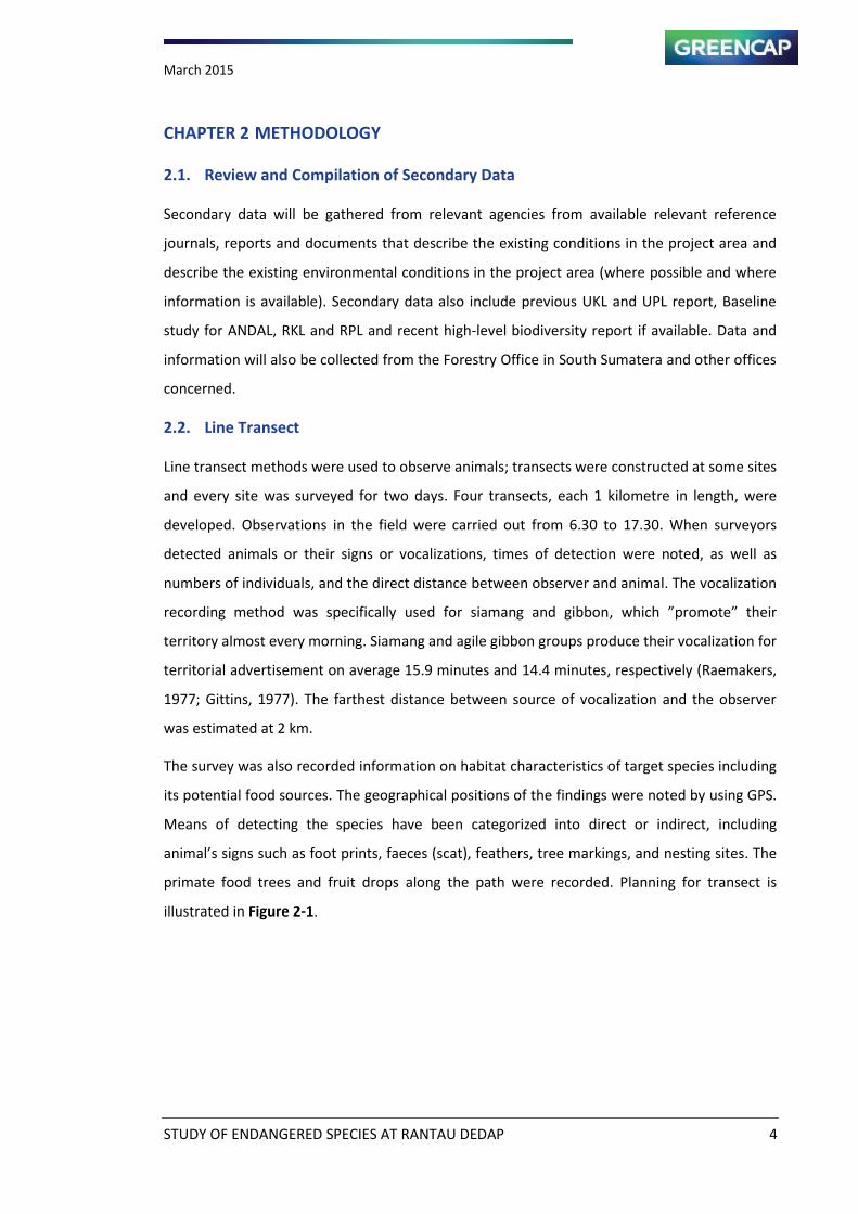
primate food trees and fruit drops along the path were recorded. Planning for transect is
illustrated in Figure 2-1.
March 2015
STUDY OF ENDANGERED SPECIES AT RANTAU DEDAP 5
Figure 2-1 Line Transect to Primate Observation
The strip width of line transect was estimated at 50 m (Willson and Willson, 1972). This is due
to the vegetation of montane forest habitat in survey area was not too dense.
2.3. Mist net
Mist net is net-shaped fauna trap. Mist net is generally used for birds and small mammals,
such as bats. Mist net has a variety of sizes depend on target species. Mist nets are used to
catch a flying squirrel. Mist net length ranges between 3-18 meters with a width of 2.5 meters.
Survey will installed 2 – 5 of camera traps on study area.
2.4. Camera Trapping
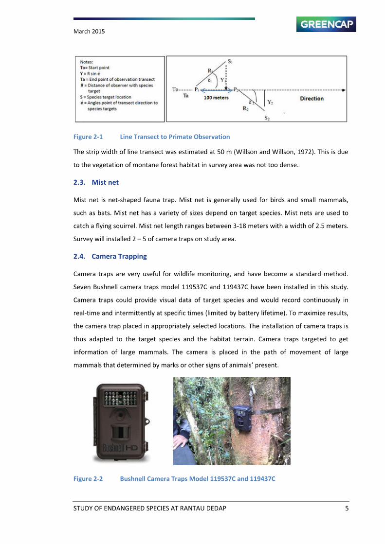
Camera traps are very useful for wildlife monitoring, and have become a standard method.
Seven Bushnell camera traps model 119537C and 119437C have been installed in this study.
Camera traps could provide visual data of target species and would record continuously in
real-time and intermittently at specific times (limited by battery lifetime). To maximize results,
the camera trap placed in appropriately selected locations. The installation of camera traps is
thus adapted to the target species and the habitat terrain. Camera traps targeted to get
information of large mammals. The camera is placed in the path of movement of large
mammals that determined by marks or other signs of a i als prese t.
Figure 2-2 Bushnell Camera Traps Model 119537C and 119437C
March 2015
STUDY OF ENDANGERED SPECIES AT RANTAU DEDAP 6
2.5. Rapid Observation
Rapid observation is a non-transect method of data collection with route. Survey route follows
the movement of the target species. In addition to line transects, surveyors also followed the
existing foot trails in the forest. Basically, this technique is the same as the line transect,
differing in the use of the existing trails on ridges or along streams, as well as along the
borders between plantations and forest. In total, surveyors walked 20 kilometres along both
line transects and existing foot trails.
For large mammals, survey has been focused on ridges and hills. Ridges are commonly used by
animals as movement routes. For primate species, the routes were followed its food trees in
the forest and the edge of forest bordering plantation areas. The information of habitat use
were derived from direct findings and information from local residents and proje t s orker.
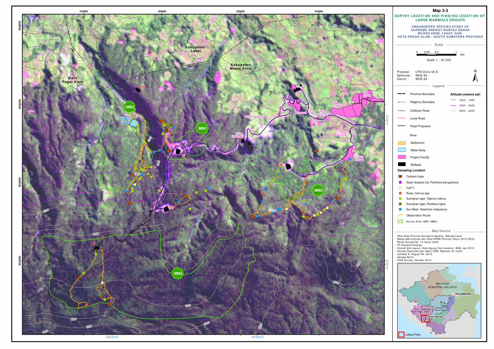
Locations of transects, observation routes, and camera traps are shown on Map 3-2 and
Map 3-3.
2.6. Community Interview
Large portions of the study area in the lower altitudes have been converted into villages and
coffee plantations. Surveyors surveyed the remaining forest adjacent to the plantations where
people still find Leaf monkeys (P. melalophos). In the villages, interviews with people have
been conducted specifically on their experiences with wildlife that still exists in the area.
Residents were questioned on whether they have seen specific animals in recent years (up to 3
years back). People are also asked whether they hunt animals or they have experienced
threats from wildlife during their residence in the village. These interviewed villages have been
identified based on the results of previous reconnaissance trip.
2.7. Habitat Modelling
Habitat analysis used the Maximum Entropy (MaxEnt) Model. MaxEnt is a general purpose
algorithm for estimating a target probability distribution by findings of the probability
distribution of maximum entropy. The model for a species is determined from a set of
environmental layers (or "coverage") in a landscape, together with a set of sample locations
where the species has been observed. The model expresses the suitability of each grid cell as
a function of the environmental variables at that grid cell. A high value of the function at a
particular grid cell indicates that the grid cell is predicted to have suitable conditions for that
species. The computed model is a probability distribution over all the grid cells. The
March 2015
STUDY OF ENDANGERED SPECIES AT RANTAU DEDAP 7
distribution chosen is the one that has maximum entropy, subject to some constraints: it must
have the same expectation for each feature (derived from the environmental layers) as the
average over sample locations.
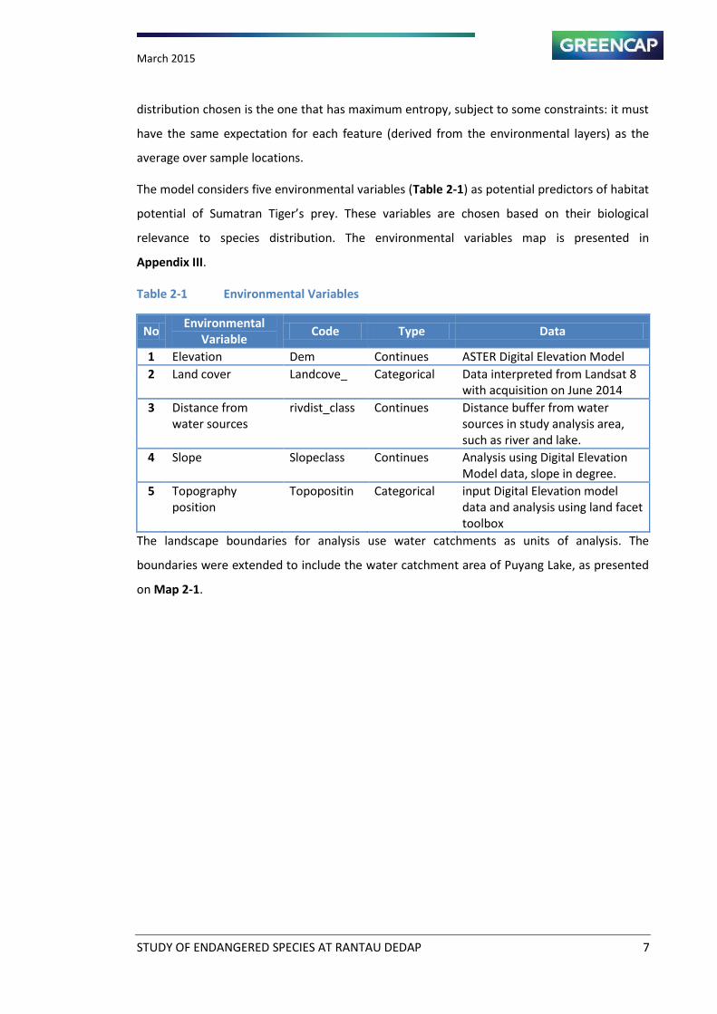
The model considers five environmental variables (Table 2-1) as potential predictors of habitat
pote tial of “u atra Tiger s prey. These aria les are hose ased o their iologi al
relevance to species distribution. The environmental variables map is presented in
Appendix III.
Table 2-1 Environmental Variables
No Environmental
Variable Code Type Data
1 Elevation Dem Continues ASTER Digital Elevation Model
2 Land cover Landcove_ Categorical Data interpreted from Landsat 8
with acquisition on June 2014
3 Distance from
water sources
rivdist_class Continues Distance buffer from water
sources in study analysis area,
such as river and lake.
4 Slope Slopeclass Continues Analysis using Digital Elevation
Model data, slope in degree.
5 Topography
position
Topopositin Categorical input Digital Elevation model
data and analysis using land facet
toolbox
The landscape boundaries for analysis use water catchments as units of analysis. The
boundaries were extended to include the water catchment area of Puyang Lake, as presented
on Map 2-1.
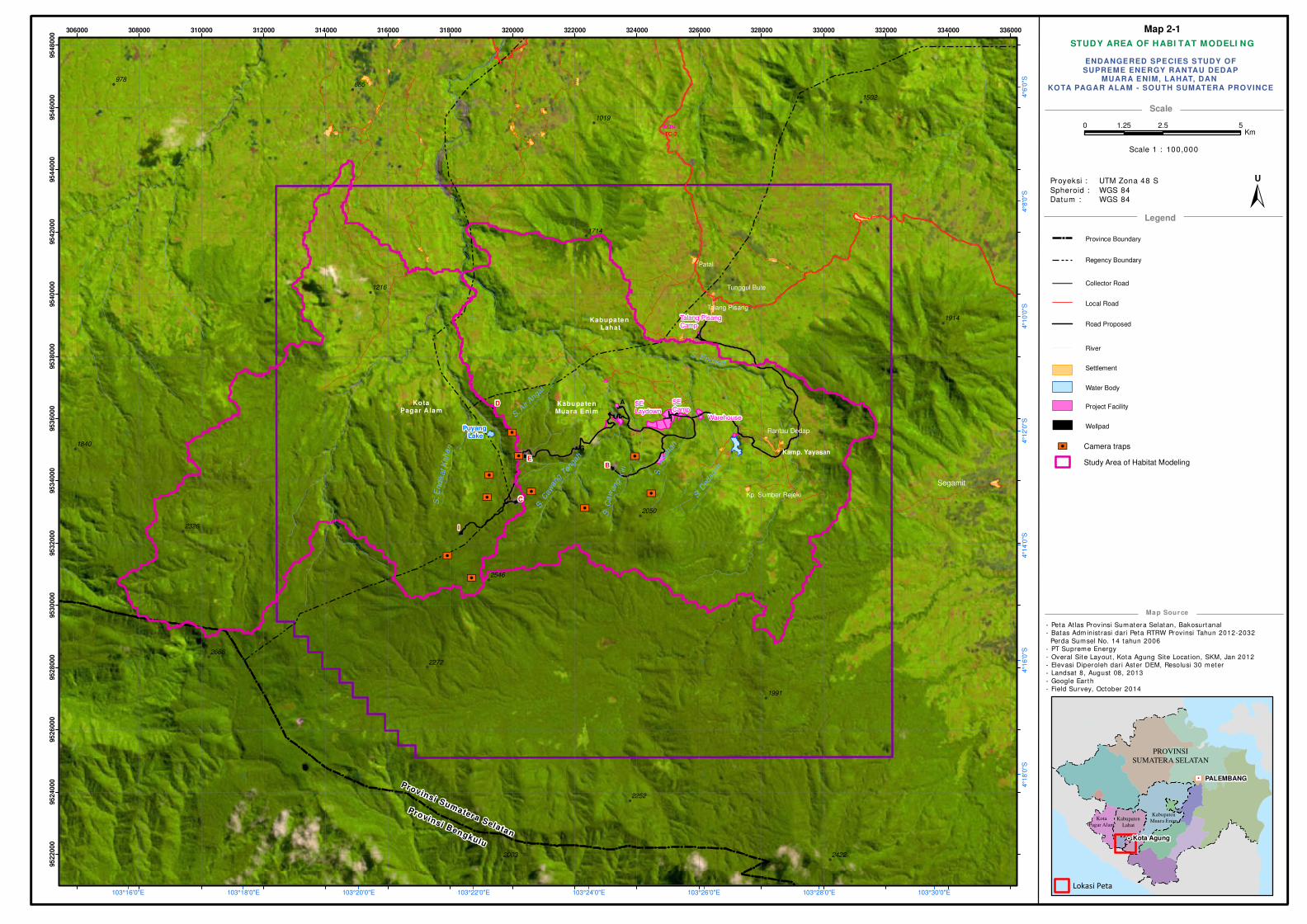
STUDY AREA OF HABI TAT MODELI NG
- Peta Atlas Provinsi Sumatera Selatan, Bakosurtanal
- Batas Adm inist rasi dari Peta RTRW Provinsi Tahun 2012-2032
Perda Sumsel No. 14 tahun 2006
- PT Supreme Energy
- Overal Site Layout , Kota Agung Site Locat ion, SKM, Jan 2012
- Elevasi Diperoleh dar i Aster DEM, Resolusi 30 meter
- Landsat 8, August 08, 2013
- Google Ear th
- Field Survey, October 2014
Scale
Legend
Map Source
! !!
!
! !
!
!
!
!!
! !!!
!!
!
!
!!
!
!
!
! !
!
!
!
!
!
!
!
!
!!
!
!
!
!
!
!
!
!!
!
!
!!!
!!
!
!
!
!
!
!
!
!
!
!
!
!
!
!
!
!
!
!H
PROVINSI
SUMATERA SELATAN
PALEMBANG
Kota Agung
Kota
Pagar Alam
Kabupaten
Lahat
Kabupaten
Muara Enim
Lokasi Peta
Province Boundary
Regency Boundary
Collector Road
Local Road
Road Proposed
Water Body
Settlement
Project Facility
Wellpad
ENDANGERED SPECIES STUDY OFSUPREME ENERGY RANTAU DEDAP
MUARA ENIM, LAHAT, DAN KOTA PAGAR ALAM - SOUTH SUMATERA PROVINCE
Proyeksi :
Spheroid :
Datum :
UTM Zona 48 S
WGS 84
WGS 84
"/
!(
!(
!(
!(
!(
!( !(
!(
!(
!(
!(
!(
!(
!(
!(
!(
!(
:9
:9
:9
:9
:9
:9 :9
:9:9
:9
A SE Camp
SE Laydown
Warehouse
B
G
C
D
Kabupaten Lahat
Kabupaten Muara Enim
Rantau Dedap
Segamit
Talang Pisang
Tunggul Bute
Patal
Kp. Sumber Rejeki
I
Talang Pisang Camp
Kamp. YayasanE
Puyang Lake
KotaPagar Alam
Provinsi Sumatera Selatan
Provinsi Bengkulu
AQN-5
TC-2
S.
Asa
han
S.E
ndik
at
Kan
an
S. End ikat
S.
Ca
wan
gK
i ri
S. D
edap
an
S. C
aw
ang
Tenga
h
S. Air
Angat
978885
2272
1991
1216
2326
1714
2050
1502
1840
2252
24222003
2666
2546
1914
1019
103°30'0"E103°28'0"E103°26'0"E103°24'0"E103°22'0"E103°20'0"E103°18'0"E103°16'0"E
4°6
'0"S
4°8
'0"S
4°1
0'0
"S4°1
2'0
"S4°1
4'0
"S4°1
6'0
"S4°1
8'0
"S
306000 308000 310000 312000 314000 316000 318000 320000 322000 324000 326000 328000 330000 332000 334000 336000
95
22
00
095
24
00
095
26
00
095
28
00
095
30
00
095
32
00
095
34
00
095
36
00
095
38
00
095
40
00
095
42
00
095
44
00
095
46
00
095
48
00
0
0 2.5 51.25Km
±U
Scale 1 : 100,000
:9 Camera traps
Study Area of Habitat Modeling
River
Map 2-1
March 2015
STUDY OF ENDANGERED SPECIES AT RANTAU DEDAP 9
CHAPTER 3 THE FINDINGS
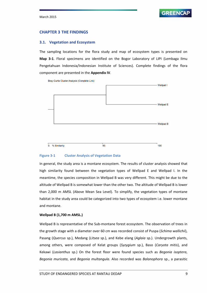
3.1. Vegetation and Ecosystem
The sampling locations for the flora study and map of ecosystem types is presented on
Map 3-1. Floral specimens are identified on the Bogor Laboratory of LIPI (Lembaga Ilmu
Pengetahuan Indonesia/Indonesian Institute of Sciences). Complete findings of the flora
component are presented in the Appendix IV.
Figure 3-1 Cluster Analysis of Vegetation Data
In general, the study area is a montane ecosystem. The results of cluster analysis showed that
high similarity found between the vegetation types of Wellpad E and Wellpad I. In the
meantime, the species composition in Wellpad B was very different. This might be due to the
altitude of Wellpad B is somewhat lower than the other two. The altitude of Wellpad B is lower
than 2,000 m AMSL (Above Mean Sea Level). To simplify, the vegetation types of montane
habitat in the study area could be categorized into two types of ecosystem i.e. lower montane
and montane.
Wellpad B (1,700 m AMSL.)
Wellpad B is representative of the Sub-montane forest ecosystem. The observation of trees in
the growth stage with a diameter over 60 cm was recorded consist of Puspa (Schima wallichii),
Pasang (Quercus sp.), Medang (Litsea sp.), and Kebe elang (Aglaia sp.). Undergrowth plants,
among others, were composed of Kelat groups (Syzygium sp.), Baso (Caryota mitis), and
Kekawi (Lasianthus sp.) On the forest floor were found species such as Begonia isoptera,
Begonia muricata, and Begonia multangula. Also recorded was Balanophora sp., a parasitic
March 2015
STUDY OF ENDANGERED SPECIES AT RANTAU DEDAP 10
plant that roots on trees of Quercus sp. Some pioneer plants were found, including Sepat
(Ficus sp.) and Jelatang (Laportea stimulant).
A secondary mountain plant species found to be quite dominant is Maleuleu (Litsea cubeba).
Palm groups, especially species of rattan, are rarely found, because elevation factors in the
study area do not support growth of these species. The species distribution caused by altitude
(elevation effect) factors is Vaccinium varingiaefolium (epiphyte species). Another common
plant is edelweiss (Anaphalis longifolia). Plant species mentioned are common species found in
the mountain forests of Java as well as Sumatra.
Wellpad E (2,000 m AMSL.)
Wellpad E is in the sub-montane forest ecosystem, with the dominant flora including
Lengkedai (Dacrycarpus imbricatus) and Lengkedai daun (Taxus sumatranus). Both trees are
commonly used for building material by local communities. Lengkedai daun, endemic to
Sumatra, here is was found quite dominant and abundant in the hilly areas. This plant became
famous because of its alleged potential as cancer drug, but this factor is still in research. Other
tree species recorded are Syzygium sp., Medang, Cihu (Schima wallichii) and Litsea cubeba. In
the second canopy layer are found Syzygium lineatum with elliptical leaves, Neolitsea sp.,
Evodia latifolia, and Litsea sp. On the forest floor was recorded Sarcandra glabra, Argostemma
montanum, Begonia muricata as dominant species, as well as Sonerilla sp., Medinilla speciosa,
Polygonum sp., and Ficus sp.
Wellpad I (2,200 m AMSL)
This area is in the montane moss forest ecosystem; generally, tree roots are covered by moss.
The composition of the forest is dominated by Taxus sumatrana and Dacrycarpus imbricatus.
Common species found are Weinmania sp., Liquidambar sp. Cinnamomum sp., Syzygium sp.,
and Cihu (Schima wallichii). in the lower forest canopy are found Lasianthus sp., Litsea sp, Acer
laurinum, Symplocos sp., and Proteaceae family species. Liana plants are rare, except Rubus sp.
and Lasianthus sp., indicating the forest is still in good condition. On the forest floor were
found Sonnerila sp., Elatostemma sp., Impatiens sp 3 which is also believed to be an endemic
species not previously recorded.

March 2015
STUDY OF ENDANGERED SPECIES AT RANTAU DEDAP 11
Impatien sp groups
Taxus sumatrana
Figure 3-2 Species Findings of Vegetation Study
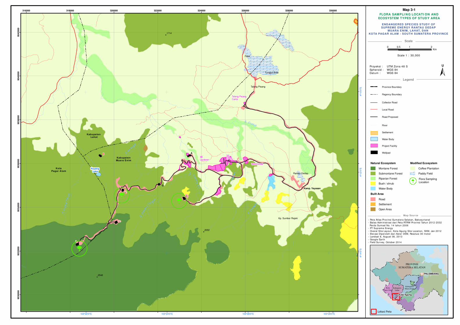
FLORA SAMPLI N G LOCATI ON AND
ECOSYSTEM TYPES OF STUDY AREA
- Peta Atlas Provinsi Sumatera Selatan, Bakosurtanal
- Batas Adm inist rasi dari Peta RTRW Provinsi Tahun 2012-2032
Perda Sumsel No. 14 tahun 2006
- PT Supreme Energy
- Overal Site Layout , Kota Agung Site Locat ion, SKM, Jan 2012
- Elevasi Diperoleh dar i Aster DEM, Resolusi 30 meter
- Landsat 8, August 08, 2013
- Google Ear th
- Field Survey, October 2014
Scale
Legend
Map Source
! !!
!
! !
!
!
!
!!
! !!!
!!
!
!
!!
!
!
!
! !
!
!
!
!
!
!
!
!
!!
!
!
!
!
!
!
!
!!
!
!
!!!
!!
!
!
!
!
!
!
!
!
!
!
!
!
!
!
!
!
!
!H
PROVINSI
SUMATERA SELATAN
PALEMBANG
Kota Agung
Kota
Pagar Alam
Kabupaten
Lahat
Kabupaten
Muara Enim
Lokasi Peta
Province Boundary
Regency Boundary
Collector Road
Local Road
Road Proposed
Water Body
Settlement
Project Facility
Wellpad
ENDANGERED SPECIES STUDY OFSUPREME ENERGY RANTAU DEDAP
MUARA ENIM, LAHAT, DAN KOTA PAGAR ALAM - SOUTH SUMATERA PROVINCE
Proyeksi :
Spheroid :
Datum :
UTM Zona 48 S
WGS 84
WGS 84
"/!(
!(
!(
A SE Camp
SE Laydown
Warehouse
B
G
C
D
Kabupaten Lahat
Kabupaten Muara Enim
Rantau Dedap
Talang Pisang
Tunggul Bute
Patal
Kp. Sumber Rejeki
I
Talang Pisang Camp
Kamp. Yayasan
lE
l
l
Puyang Lake
C
D
l
KotaPagar Alam
S.
Asa
ha
n
S.E
ndik
atK
ana
n
S. Endikat
S. C
awang
Kiri
S. D
edap
an
S. C
aw
ang
T
engah
S. Air
Angat
1714
2050
2546
103°28'0"E103°26'0"E103°24'0"E103°22'0"E
4°1
0'0
"S4°1
2'0
"S4°1
4'0
"S
316000 318000 320000 322000 324000 326000 328000 330000
95
30
00
095
32
00
095
34
00
095
36
00
095
38
00
095
40
00
095
42
00
0
0 1 20.5Km
±U
Scale 1 : 30,000
Natural Ecosystem
Montane Forest
Submontane Forest
Riparian Forest
Bush / shrub
Water Body
Built Area
Road
Settlement
Open Area
Modified Ecosystem
Coffee Plantation
Paddy Field
River
lFlora SamplingLocation
Map 3-1
March 2015
STUDY OF ENDANGERED SPECIES AT RANTAU DEDAP 13
3.2. Species Targets
3.2.1. Primates
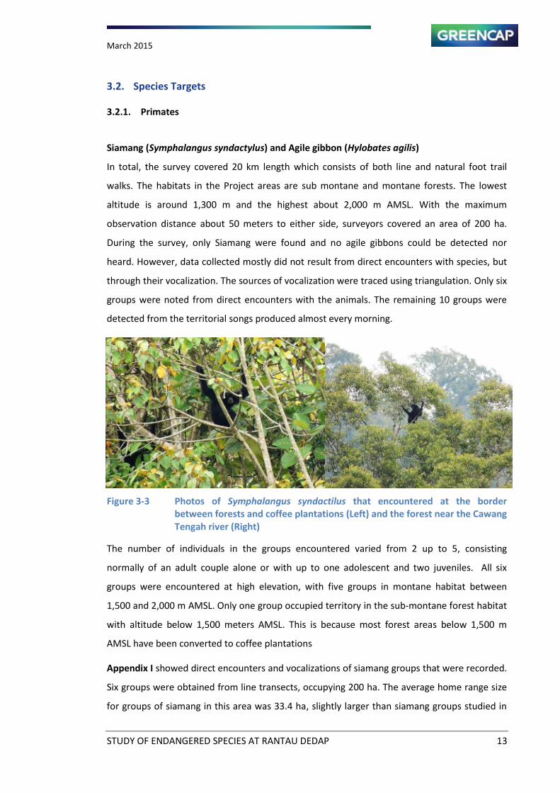
Siamang (Symphalangus syndactylus) and Agile gibbon (Hylobates agilis)
In total, the survey covered 20 km length which consists of both line and natural foot trail
walks. The habitats in the Project areas are sub montane and montane forests. The lowest
altitude is around 1,300 m and the highest about 2,000 m AMSL. With the maximum
observation distance about 50 meters to either side, surveyors covered an area of 200 ha.
During the survey, only Siamang were found and no agile gibbons could be detected nor
heard. However, data collected mostly did not result from direct encounters with species, but
through their vocalization. The sources of vocalization were traced using triangulation. Only six
groups were noted from direct encounters with the animals. The remaining 10 groups were
detected from the territorial songs produced almost every morning.
Figure 3-3 Photos of Symphalangus syndactilus that encountered at the border
between forests and coffee plantations (Left) and the forest near the Cawang
Tengah river (Right)
The number of individuals in the groups encountered varied from 2 up to 5, consisting
normally of an adult couple alone or with up to one adolescent and two juveniles. All six
groups were encountered at high elevation, with five groups in montane habitat between
1,500 and 2,000 m AMSL. Only one group occupied territory in the sub-montane forest habitat
with altitude below 1,500 meters AMSL. This is because most forest areas below 1,500 m
AMSL have been converted to coffee plantations
Appendix I showed direct encounters and vocalizations of siamang groups that were recorded.
Six groups were obtained from line transects, occupying 200 ha. The average home range size
for groups of siamang in this area was 33.4 ha, slightly larger than siamang groups studied in
March 2015
STUDY OF ENDANGERED SPECIES AT RANTAU DEDAP 14
the Kuala Lompat forest, Malaysia, which utilize 32 ha of forest habitat (Chivers, 1984). The
availability of food trees particularly with fleshy fruit is reduced with increasing altitude. This
was clearly shown by a study of habitat quality of two sympatric gibbons on montane habitat
on the Malay Peninsula (Caldecott, 1980). Because of climate, soil, and drainage, the supply of
fruit to agile gibbons decreases in abundance with elevation. This renders highland areas less
favourable to agile gibbon than to siamang, which is less frugivorous (Raemakers, 1984). The
only fleshy fruit bearing trees which are a dominant species in the study area are Syzygium
spp. This is one of the explanation why the Agile gibbon (Hylobates agilis) could not be found
in the study area.
O Brie et.al fou d i Bukit Barisa “elata Natio al Park that Agile gibbon and Siamang
density are negatively correlated, with agile gibbon most abundant in mid-elevation forests
(400 – 600 m AMSL) and Siamang most abundant in lowland (< 400 m AMSL) and sub-montane
(1,000 – 1,500 m AMSL) forests. In this study, the agile gibbon (Hylobates agilis) was neither
encountered nor heard of its vocalization. Since the Project area consists of high elevation
montane forest habitat, only a few groups of siamang exist.
Observer has discovered Siamang in the plantation near the forest edge. When it overlays with
land cover, the results indicate that the Siamang group was trapped on small forest. This was
due to the impact of forest fragmentation. This group of Siamang has been trapped in the
forest isla d . If it is not well manage the group becomes threatened. Observer has
estimated five individuals of Siamang.
The coverage area was calculated based on the radius of the farthest distance between
observer and source of vocalization which is estimated at 2 km length. There is 16 groups of
siamang has been documented within 48 km2 forest area. Therefore, only 0.3 group/km
2 occur
in the survey area. This number is much lower than the density of siamang in Gunung Tujuh
(2,100 m AMSL) in Kerinci Seblat National Park, west Sumatra which is 2.7 groups/km2 (Wood,
et.al., 1996). The total number of tree stands with diameter more than 30 cm is less than 200
trees/ha. This number was obtained from 50 plots each 200 m2 (range 2–7 trees/plot). In the
last 10 years in south Sumatra of Barisan Montane range, illegal deforestation has increased
up to the sub-montane forest habitat (1,000–1,400 m AMSL.). Currently, the forest in this
region has been converted to coffee plantation and the encroachment went up to montane
forest as seen in the map of Project area. Map 3-2 showed the distribution of Siamang in the
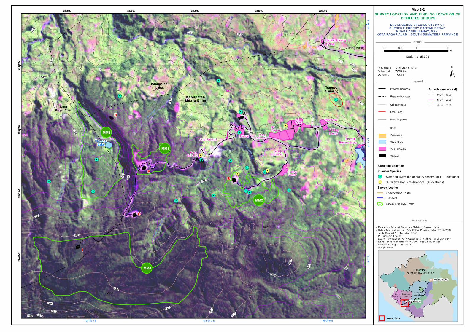
Project area is dispersed in the forest surroundings Wellpad A through E and Wellpad I.
March 2015
STUDY OF ENDANGERED SPECIES AT RANTAU DEDAP 15
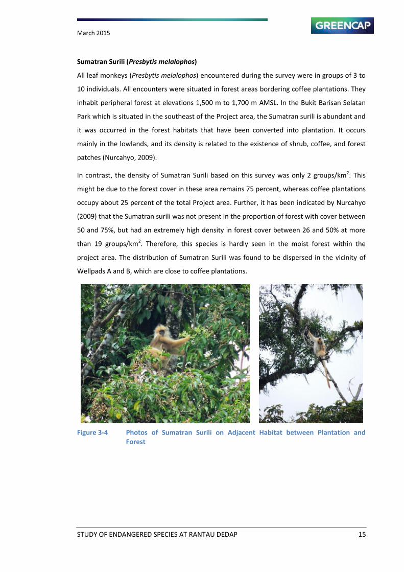
Sumatran Surili (Presbytis melalophos)
All leaf monkeys (Presbytis melalophos) encountered during the survey were in groups of 3 to
10 individuals. All encounters were situated in forest areas bordering coffee plantations. They
inhabit peripheral forest at elevations 1,500 m to 1,700 m AMSL. In the Bukit Barisan Selatan
Park which is situated in the southeast of the Project area, the Sumatran surili is abundant and
it was occurred in the forest habitats that have been converted into plantation. It occurs
mainly in the lowlands, and its density is related to the existence of shrub, coffee, and forest
patches (Nurcahyo, 2009).
In contrast, the density of Sumatran Surili based on this survey was only 2 groups/km2. This
might be due to the forest cover in these area remains 75 percent, whereas coffee plantations
occupy about 25 percent of the total Project area. Further, it has been indicated by Nurcahyo
(2009) that the Sumatran surili was not present in the proportion of forest with cover between
50 and 75%, but had an extremely high density in forest cover between 26 and 50% at more
than 19 groups/km2. Therefore, this species is hardly seen in the moist forest within the
project area. The distribution of Sumatran Surili was found to be dispersed in the vicinity of
Wellpads A and B, which are close to coffee plantations.
Figure 3-4 Photos of Sumatran Surili on Adjacent Habitat between Plantation and
Forest
SURVEY LOCATI ON AND FI N DI NG LOCATI ON OF
PRI MATES GROUPS
- Peta Atlas Provinsi Sumatera Selatan, Bakosurtanal
- Batas Adm inist rasi dari Peta RTRW Provinsi Tahun 2012-2032
Perda Sumsel No. 14 tahun 2006
- PT Supreme Energy
- Overal Site Layout , Kota Agung Site Locat ion, SKM, Jan 2012
- Elevasi Diperoleh dar i Aster DEM, Resolusi 30 meter
- Landsat 8, August 08, 2013
- Google Ear th
Scale
Legend
Map Source
! !!
!
! !
!
!
!
!!
! !!!
!!
!
!
!!
!
!
!
! !
!
!
!
!
!
!
!
!
!!
!
!
!
!
!
!
!
!!
!
!
!!!
!!
!
!
!
!
!
!
!
!
!
!
!
!
!
!
!
!
!
!H
PROVINSI
SUMATERA SELATAN
PALEMBANG
Kota Agung
Kota
Pagar Alam
Kabupaten
Lahat
Kabupaten
Muara Enim
Lokasi Peta
Province Boundary
Regency Boundary
Collector Road
Local Road
Road Proposed
Water Body
Settlement
Project Facility
Wellpad
ENDANGERED SPECIES STUDY OFSUPREME ENERGY RANTAU DEDAP
MUARA ENIM, LAHAT, DAN KOTA PAGAR ALAM - SOUTH SUMATERA PROVINCE
Proyeksi :
Spheroid :
Datum :
UTM Zona 48 S
WGS 84
WGS 84
"/
!(
!(
!.
!.
!.
!.
!.
!.
!.
!.
!.
!.
!.
!.
!.
!.!.
!.
!.
!.!.
!.
!.
A
Pump Station#2
SE Camp
SE Laydown
Warehouse
Hardfill Borrow Area
Cutting Bunker
B
G
C
D
KotaPagar Alam
Kabupaten Muara Enim
Talang Pisang
I
Drilling Camp
Talang Pisang Camp
Pump Station #2
Pump Station#3
Pump Station #5
Shortcut
E
MM3
MM1
MM4
MM2
Puyang Lake
Kabupaten Lahat
S
. Asahan
S.
Endik
at
Kan
an
S. Endikat
S. Caw
ang
Kiri
S. D
edapan
S.C
awang
Tengah
S. Air
Angat
1800
1700
1600 1500
1400
1900
2000
2100
1300
2200
2300
1200
1100
2400
2500
1000
26002600
1400
1400
2200
1800
2100
1400
1500
2100
1400
2200
2300
2050
2546
103°26'0"E103°24'0"E103°22'0"E
4°1
0'0
"S4°1
2'0
"S4°1
4'0
"S
318000 320000 322000 324000 326000
95
32
00
095
34
00
095
36
00
095
38
00
0
0 1 20.5Km
±U
Altitude (meters asl)
1000 - 1500
1500 - 2000
2000 - 2600
Scale 1 : 35,000
Sampling Location
Primates Species
!. Siamang (Symphalangus syndactylus) ( 17 locat ions)
!. Surili (Presbyt is melalophos) (4 locat ions)
Survey location
Observat ion route
Transect
Survey Area (MM1- MM4)
River
Map 3-2
Trapped Siamang
March 2015
STUDY OF ENDANGERED SPECIES AT RANTAU DEDAP 17
3.2.2. Large Mammals
Appendix II shows the list of species that have been found during the survey either
captured by camera trap or indirectly through their sign of foot-prints. Several foot prints
of prey animals have been identified and it consists of Malayan tapir (Tapirus indicus),
Red deer (Muntiacus muntjak), Serow (Capricornis sumatrensis), wild pig (Sus scrofa),
Porcupine (Hystrix brachyura), and Sambar deer (Cervus unicolor . The prey spe ies foot
prints are common in the well pad B. The highest numbers of encounter frequencies of
species foot prints were in surroundings Wellpad B whereas; the least frequencies were
in Wellpad E which is near the lake. This was calculated by using a formula which has
been developed by Lancia et al. (1999). The most diverse of foot prints of large mammals
have been found in these forest surroundings in the altitude between 1,400 and 1,500 m
AMSL with the Malayan tapir is the most frequent. The area was located near the village
or plantation where the survey team found many active traps and snares targeted for
prey animals.
Tiger foot-print was found in the south of Wellpad B together with the Malayan Tapir,
Small Cats, and Malayan Sunbear. Among the small cats which are captured by camera
were the Asian Golden Cat (Catopuma temminckii) and the Marbled Cat (Pardofelix
marmorata). Considering the existence of high varieties of prey species in these areas, it
is assumed that the population of predator species including the Sumatran tiger and the
other cat species are living in a good quality of forest habitat. Therefore, the most
important management intervention is controlling the area from the threat of hunting
pressure. This is very crucial part of the management task in addition to the protection of
the tiger itself. Hunting can drive big cat population into rapid extinction only if it exceeds
threshold levels set by habitat quality and reproductive potential of the species (Martin
and de Maulenaer, 1988).
The prediction of prey species habitat in the Project area and surroundings is discussed
below in the Habitat Modelling chapter.
March 2015
STUDY OF ENDANGERED SPECIES AT RANTAU DEDAP 18
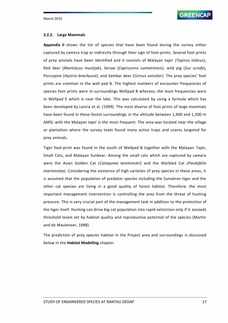
Figure 3-5 Footprint of Small Cat’s (Polymesoda bengalensis) (left) and Serow
(Capricornis sumatrensis) (Right)
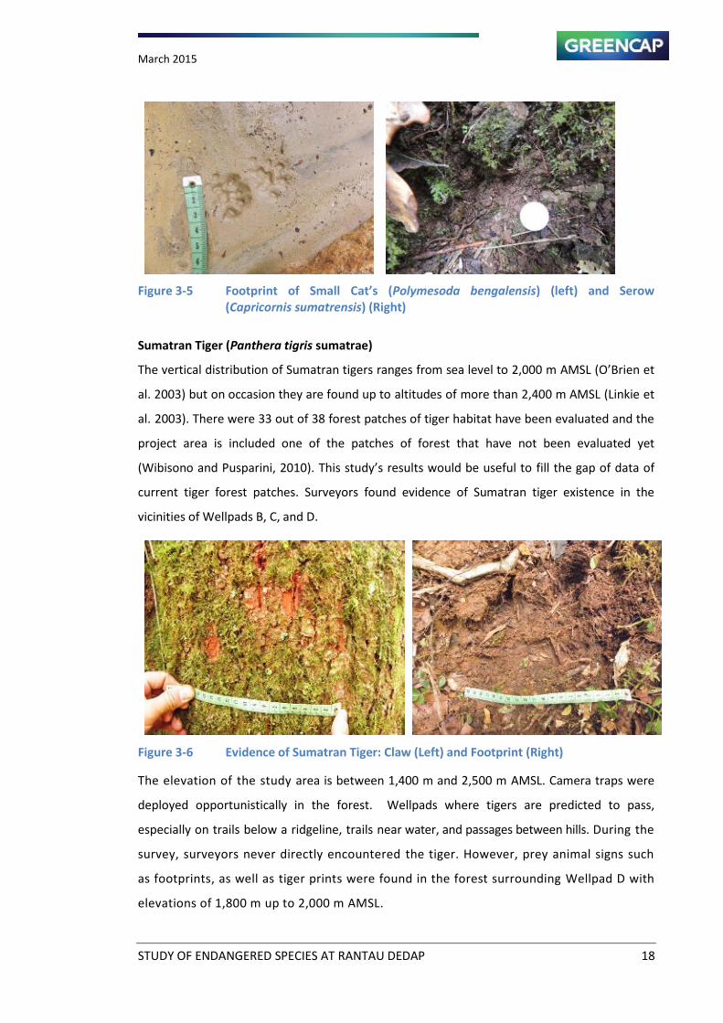
Sumatran Tiger (Panthera tigris sumatrae)
The vertical distribution of Sumatran tigers ranges from sea level to 2,000 m AMSL O Brie et
al. 2003) but on occasion they are found up to altitudes of more than 2,400 m AMSL (Linkie et
al. 2003). There were 33 out of 38 forest patches of tiger habitat have been evaluated and the
project area is included one of the patches of forest that have not been evaluated yet
(Wibisono and Pusparini, 2010). This study s results ould e useful to fill the gap of data of
current tiger forest patches. Surveyors found evidence of Sumatran tiger existence in the
vicinities of Wellpads B, C, and D.
Figure 3-6 Evidence of Sumatran Tiger: Claw (Left) and Footprint (Right)
The elevation of the study area is between 1,400 m and 2,500 m AMSL. Camera traps were
deployed opportunistically in the forest. Wellpads where tigers are predicted to pass,
especially on trails below a ridgeline, trails near water, and passages between hills. During the
survey, surveyors never directly encountered the tiger. However, prey animal signs such
as footprints, as well as tiger prints were found in the forest surrounding Wellpad D with
elevations of 1,800 m up to 2,000 m AMSL.
March 2015
STUDY OF ENDANGERED SPECIES AT RANTAU DEDAP 19
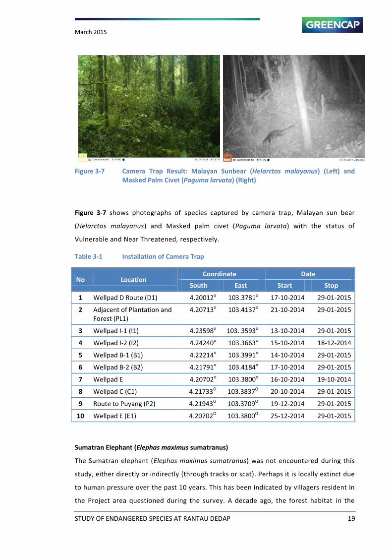
Figure 3-7 Camera Trap Result: Malayan Sunbear (Helarctos malayanus) (Left) and
Masked Palm Civet (Paguma larvata) (Right)
Figure 3-7 shows photographs of species captured by camera trap, Malayan sun bear
(Helarctos malayanus) and Masked palm civet (Paguma larvata) with the status of
Vulnerable and Near Threatened, respectively.
Table 3-1 Installation of Camera Trap
No Location Coordinate Date
South East Start Stop
1 Wellpad D Route (D1) 4.20012o
103.3781o 17-10-2014 29-01-2015
2 Adjacent of Plantation and
Forest (PL1)
4.20713o 103.4137
o 21-10-2014 29-01-2015
3 Wellpad I-1 (I1) 4.23598o 103. 3593
o 13-10-2014 29-01-2015
4 Wellpad I-2 (I2) 4.24240o 103.3663
o 15-10-2014 18-12-2014
5 Wellpad B-1 (B1) 4.22214o 103.3991
o 14-10-2014 29-01-2015
6 Wellpad B-2 (B2) 4.21791o 103.4184
o 17-10-2014 29-01-2015
7 Wellpad E 4.20702o 103.3800
o 16-10-2014 19-10-2014
8 Wellpad C (C1) 4.21733O 103.3837
O 20-10-2014 29-01-2015
9 Route to Puyang (P2) 4.21943O 103.3709
O 19-12-2014 29-01-2015
10 Wellpad E (E1) 4.20702O 103.3800
O 25-12-2014 29-01-2015
Sumatran Elephant (Elephas maximus sumatranus)
The Sumatran elephant (Elephas maximus sumatranus) was not encountered during this
study, either directly or indirectly (through tracks or scat). Perhaps it is locally extinct due
to human pressure over the past 10 years. This has been indicated by villagers resident in
the Project area questioned during the survey. A decade ago, the forest habitat in the
March 2015
STUDY OF ENDANGERED SPECIES AT RANTAU DEDAP 20
survey area was included on the list of small fragmented forest where Sumatran
elephants could be found (Soehartono et al., 2007). According to the Sumatran Elephant
Conservation Action Plan and Strategies, the population for the whole island was estimated at
2,400 to 2,800 individual wild elephants (excluding elephants in camps), in 25 fragmented
populations (Soehartono et al. 2007). Most of these populations are living in the lowland
areas. People kill elephants for its tusk.
Illegal killing of elephants by villagers, commonly by poisoning, as retaliation for conflicts with
elephants is also considered a serious problem and contributed to the declining elephant
populations (Hedges et al. 2005; Uryu et al. 2008). Results of surveys by the Wildlife Crimes
Unit to the owner of protected species stuffs in Lampung province were shown that the stuffs
of Sumatran elephant and Sumatran tiger were the most common found (Soehartono et al.,
2007).
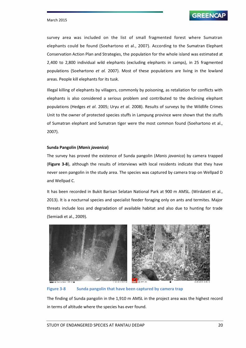
Sunda Pangolin (Manis javanica)
The survey has proved the existence of Sunda pangolin (Manis javanica) by camera trapped
(Figure 3-8), although the results of interviews with local residents indicate that they have
never seen pangolin in the study area. The species was captured by camera trap on Wellpad D
and Wellpad C.
It has been recorded in Bukit Barisan Selatan National Park at 900 m AMSL. (Wirdateti et al.,
2013). It is a nocturnal species and specialist feeder foraging only on ants and termites. Major
threats include loss and degradation of available habitat and also due to hunting for trade
(Semiadi et al., 2009).
Figure 3-8 Sunda pangolin that have been captured by camera trap
The finding of Sunda pangolin in the 1,910 m AMSL in the project area was the highest record
in terms of altitude where the species has ever found.
March 2015
STUDY OF ENDANGERED SPECIES AT RANTAU DEDAP 21
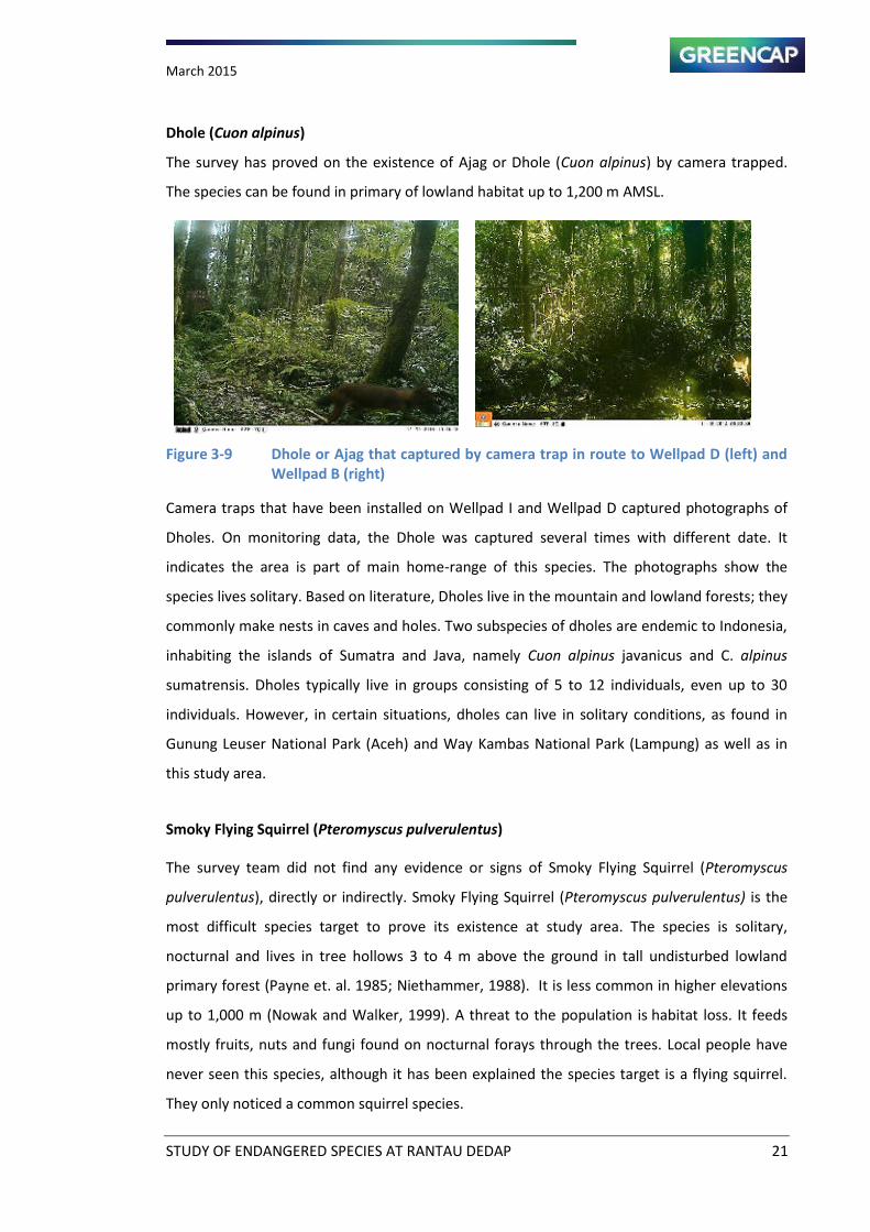
Dhole (Cuon alpinus)
The survey has proved on the existence of Ajag or Dhole (Cuon alpinus) by camera trapped.
The species can be found in primary of lowland habitat up to 1,200 m AMSL.
Figure 3-9 Dhole or Ajag that captured by camera trap in route to Wellpad D (left) and
Wellpad B (right)
Camera traps that have been installed on Wellpad I and Wellpad D captured photographs of
Dholes. On monitoring data, the Dhole was captured several times with different date. It
indicates the area is part of main home-range of this species. The photographs show the
species lives solitary. Based on literature, Dholes live in the mountain and lowland forests; they
commonly make nests in caves and holes. Two subspecies of dholes are endemic to Indonesia,
inhabiting the islands of Sumatra and Java, namely Cuon alpinus javanicus and C. alpinus
sumatrensis. Dholes typically live in groups consisting of 5 to 12 individuals, even up to 30
individuals. However, in certain situations, dholes can live in solitary conditions, as found in
Gunung Leuser National Park (Aceh) and Way Kambas National Park (Lampung) as well as in
this study area.
Smoky Flying Squirrel (Pteromyscus pulverulentus)
The survey team did not find any evidence or signs of Smoky Flying Squirrel (Pteromyscus
pulverulentus), directly or indirectly. Smoky Flying Squirrel (Pteromyscus pulverulentus) is the
most difficult species target to prove its existence at study area. The species is solitary,
nocturnal and lives in tree hollows 3 to 4 m above the ground in tall undisturbed lowland
primary forest (Payne et. al. 1985; Niethammer, 1988). It is less common in higher elevations
up to 1,000 m (Nowak and Walker, 1999). A threat to the population is habitat loss. It feeds
mostly fruits, nuts and fungi found on nocturnal forays through the trees. Local people have
never seen this species, although it has been explained the species target is a flying squirrel.
They only noticed a common squirrel species.
March 2015
STUDY OF ENDANGERED SPECIES AT RANTAU DEDAP 22
3.3. Other Target Species
This chapter discusses the findings of threatened species others than the targets. The survey
has been noted and confirmed two threatened species i.e., Malayan Sunbear (Endangered),
Tapir (Endangered) and one species which still need a more detailed evidence other than just
footprint, such a picture i.e., the Serow (Capricornis sumatrensis, Endangered)
3.3.1. Large Mammals
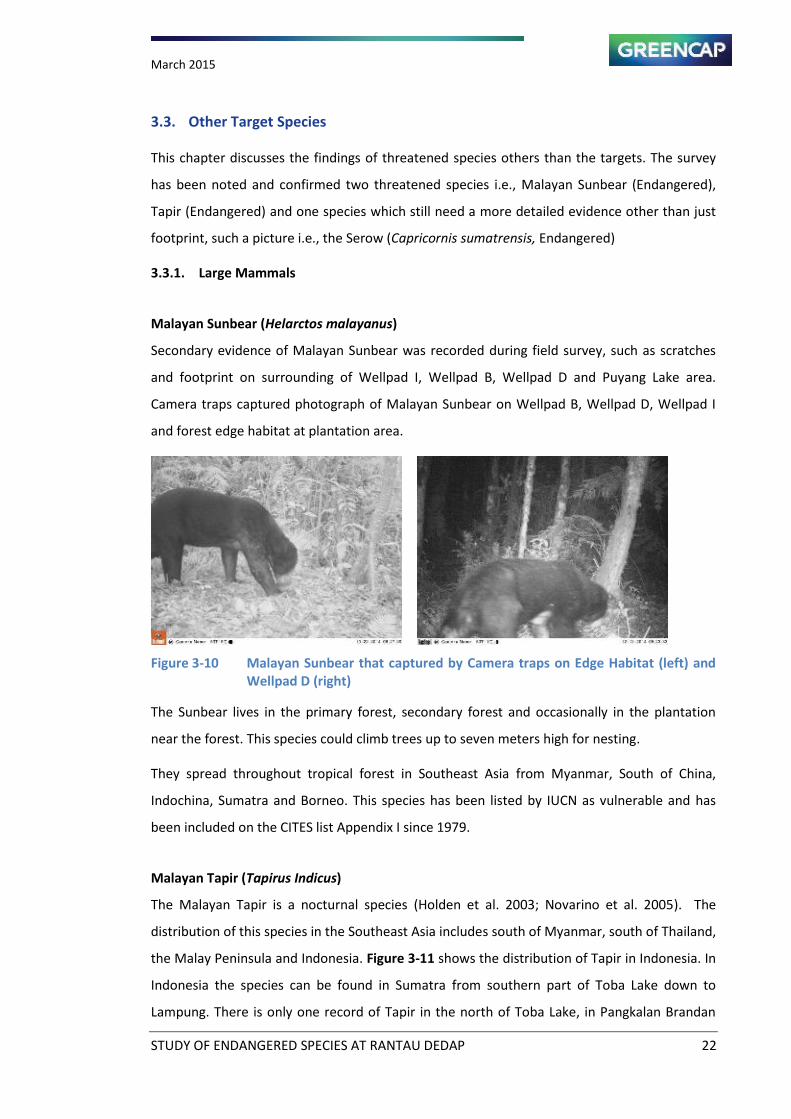
Malayan Sunbear (Helarctos malayanus)
Secondary evidence of Malayan Sunbear was recorded during field survey, such as scratches
and footprint on surrounding of Wellpad I, Wellpad B, Wellpad D and Puyang Lake area.
Camera traps captured photograph of Malayan Sunbear on Wellpad B, Wellpad D, Wellpad I
and forest edge habitat at plantation area.
Figure 3-10 Malayan Sunbear that captured by Camera traps on Edge Habitat (left) and
Wellpad D (right)
The Sunbear lives in the primary forest, secondary forest and occasionally in the plantation
near the forest. This species could climb trees up to seven meters high for nesting.
They spread throughout tropical forest in Southeast Asia from Myanmar, South of China,
Indochina, Sumatra and Borneo. This species has been listed by IUCN as vulnerable and has
been included on the CITES list Appendix I since 1979.
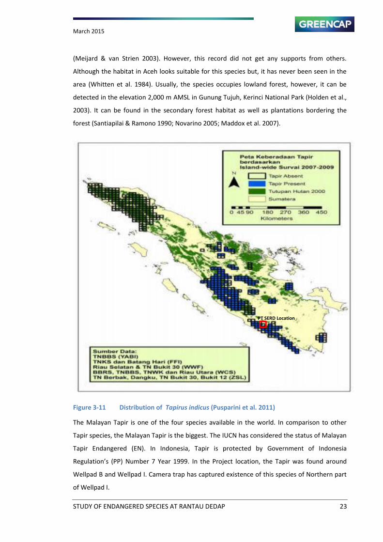
Malayan Tapir (Tapirus Indicus)
The Malayan Tapir is a nocturnal species (Holden et al. 2003; Novarino et al. 2005). The
distribution of this species in the Southeast Asia includes south of Myanmar, south of Thailand,
the Malay Peninsula and Indonesia. Figure 3-11 shows the distribution of Tapir in Indonesia. In
Indonesia the species can be found in Sumatra from southern part of Toba Lake down to
Lampung. There is only one record of Tapir in the north of Toba Lake, in Pangkalan Brandan
March 2015
STUDY OF ENDANGERED SPECIES AT RANTAU DEDAP 23
(Meijard & van Strien 2003). However, this record did not get any supports from others.
Although the habitat in Aceh looks suitable for this species but, it has never been seen in the
area (Whitten et al. 1984). Usually, the species occupies lowland forest, however, it can be
detected in the elevation 2,000 m AMSL in Gunung Tujuh, Kerinci National Park (Holden et al.,
2003). It can be found in the secondary forest habitat as well as plantations bordering the
forest (Santiapilai & Ramono 1990; Novarino 2005; Maddox et al. 2007).
Figure 3-11 Distribution of Tapirus indicus (Pusparini et al. 2011)
The Malayan Tapir is one of the four species available in the world. In comparison to other
Tapir species, the Malayan Tapir is the biggest. The IUCN has considered the status of Malayan
Tapir Endangered (EN). In Indonesia, Tapir is protected by Government of Indonesia
Regulation s PP Number 7 Year 1999. In the Project location, the Tapir was found around
Wellpad B and Wellpad I. Camera trap has captured existence of this species of Northern part
of Wellpad I.
PT SERD Location
March 2015
STUDY OF ENDANGERED SPECIES AT RANTAU DEDAP 24
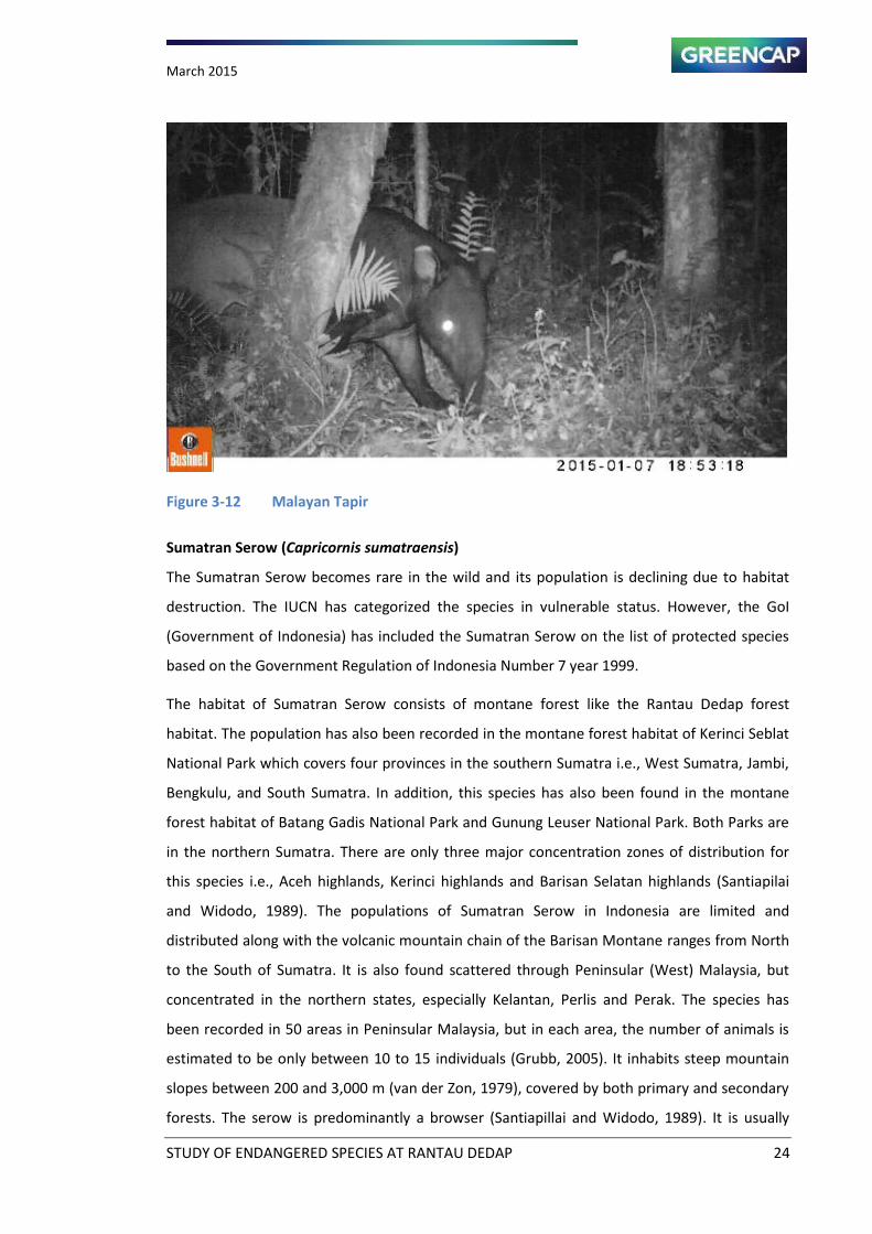
Figure 3-12 Malayan Tapir
Sumatran Serow (Capricornis sumatraensis)
The Sumatran Serow becomes rare in the wild and its population is declining due to habitat
destruction. The IUCN has categorized the species in vulnerable status. However, the GoI
(Government of Indonesia) has included the Sumatran Serow on the list of protected species
based on the Government Regulation of Indonesia Number 7 year 1999.
The habitat of Sumatran Serow consists of montane forest like the Rantau Dedap forest
habitat. The population has also been recorded in the montane forest habitat of Kerinci Seblat
National Park which covers four provinces in the southern Sumatra i.e., West Sumatra, Jambi,
Bengkulu, and South Sumatra. In addition, this species has also been found in the montane
forest habitat of Batang Gadis National Park and Gunung Leuser National Park. Both Parks are
in the northern Sumatra. There are only three major concentration zones of distribution for
this species i.e., Aceh highlands, Kerinci highlands and Barisan Selatan highlands (Santiapilai
and Widodo, 1989). The populations of Sumatran Serow in Indonesia are limited and
distributed along with the volcanic mountain chain of the Barisan Montane ranges from North
to the South of Sumatra. It is also found scattered through Peninsular (West) Malaysia, but
concentrated in the northern states, especially Kelantan, Perlis and Perak. The species has
been recorded in 50 areas in Peninsular Malaysia, but in each area, the number of animals is
estimated to be only between 10 to 15 individuals (Grubb, 2005). It inhabits steep mountain
slopes between 200 and 3,000 m (van der Zon, 1979), covered by both primary and secondary
forests. The serow is predominantly a browser (Santiapillai and Widodo, 1989). It is usually
March 2015
STUDY OF ENDANGERED SPECIES AT RANTAU DEDAP 25
solitary in nature, but small groups of up to seven have been observed (Nowak, 1991). It may
occupy seasonal ranges and use well marked trails that often run along ridges of steep hills.
Information on its reproduction is not available. Despite their wide spread distribution in the
Barisan Montane Ranges, the report on the existence of the species are lacking since the last
decade.
3.4. Biodiversity Threat
The forest habitat in the SERD Project area becomes easily accessible. Local people could enter
the forest area from many places despite active control by SERD security staff. Very wide
forest area might increase the threat of wildlife hunting and forest encroachment in the
Project area as indicated by active animal traps found in the forest area during the survey.
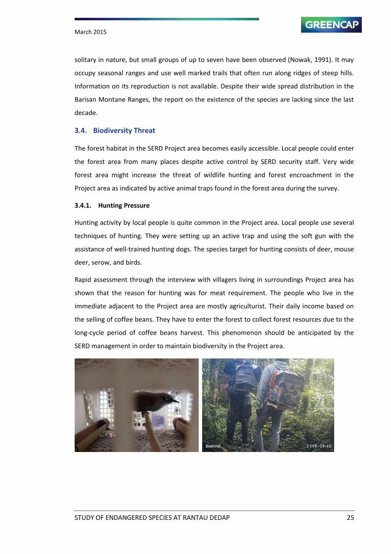
3.4.1. Hunting Pressure
Hunting activity by local people is quite common in the Project area. Local people use several
techniques of hunting. They were setting up an active trap and using the soft gun with the
assistance of well-trained hunting dogs. The species target for hunting consists of deer, mouse
deer, serow, and birds.
Rapid assessment through the interview with villagers living in surroundings Project area has
shown that the reason for hunting was for meat requirement. The people who live in the
immediate adjacent to the Project area are mostly agriculturist. Their daily income based on
the selling of coffee beans. They have to enter the forest to collect forest resources due to the
long-cycle period of coffee beans harvest. This phenomenon should be anticipated by the
SERD management in order to maintain biodiversity in the Project area.
March 2015
STUDY OF ENDANGERED SPECIES AT RANTAU DEDAP 26
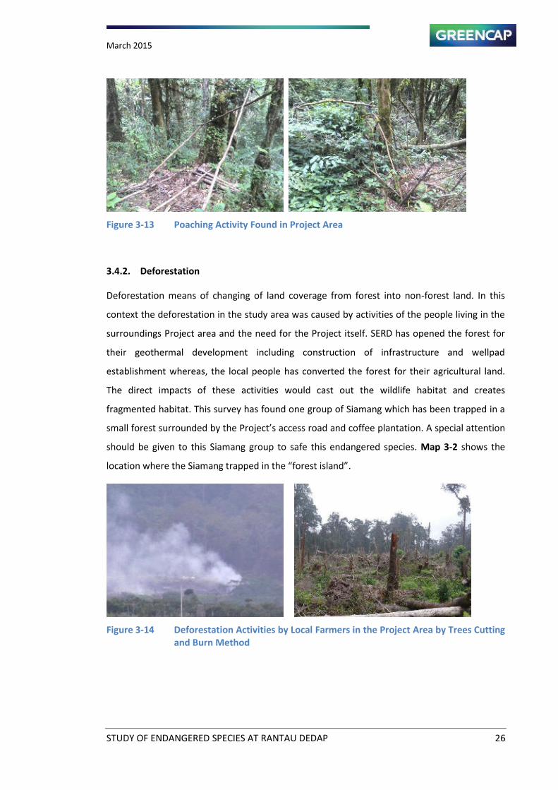
Figure 3-13 Poaching Activity Found in Project Area
3.4.2. Deforestation
Deforestation means of changing of land coverage from forest into non-forest land. In this
context the deforestation in the study area was caused by activities of the people living in the
surroundings Project area and the need for the Project itself. SERD has opened the forest for
their geothermal development including construction of infrastructure and wellpad
establishment whereas, the local people has converted the forest for their agricultural land.
The direct impacts of these activities would cast out the wildlife habitat and creates
fragmented habitat. This survey has found one group of Siamang which has been trapped in a
small forest surrounded y the Proje t s a ess road and coffee plantation. A special attention
should be given to this Siamang group to safe this endangered species. Map 3-2 shows the
lo atio here the “ia a g trapped i the forest isla d .
Figure 3-14 Deforestation Activities by Local Farmers in the Project Area by Trees Cutting
and Burn Method
March 2015
STUDY OF ENDANGERED SPECIES AT RANTAU DEDAP 27
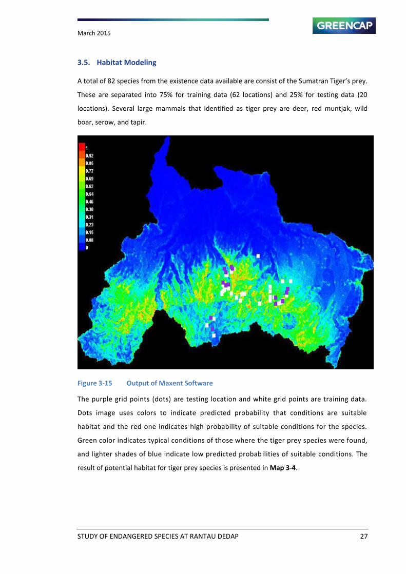
3.5. Habitat Modeling
A total of 82 species from the existence data available are consist of the Sumatran Tiger s prey.
These are separated into 75% for training data (62 locations) and 25% for testing data (20
locations). Several large mammals that identified as tiger prey are deer, red muntjak, wild
boar, serow, and tapir.
Figure 3-15 Output of Maxent Software
The purple grid points (dots) are testing location and white grid points are training data.
Dots image uses colors to indicate predicted probability that conditions are suitable
habitat and the red one indicates high probability of suitable conditions for the species.
Green color indicates typical conditions of those where the tiger prey species were found,
and lighter shades of blue indicate low predicted probabilities of suitable conditions. The
result of potential habitat for tiger prey species is presented in Map 3-4.
March 2015
STUDY OF ENDANGERED SPECIES AT RANTAU DEDAP 28
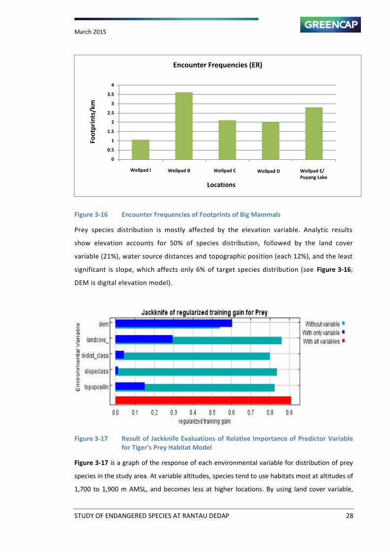
Figure 3-16 Encounter Frequencies of Footprints of Big Mammals
Prey species distribution is mostly affected by the elevation variable. Analytic results
show elevation accounts for 50% of species distribution, followed by the land cover
variable (21%), water source distances and topographic position (each 12%), and the least
significant is slope, which affects only 6% of target species distribution (see Figure 3-16;
DEM is digital elevation model).
Figure 3-17 Result of Jackknife Evaluations of Relative Importance of Predictor Variable
for Tiger’s Prey Habitat Model
Figure 3-17 is a graph of the response of each environmental variable for distribution of prey
species in the study area. At variable altitudes, species tend to use habitats most at altitudes of
1,700 to 1,900 m AMSL, and becomes less at higher locations. By using land cover variable,
0
0.5
1
1.5
2
2.5
3
3.5
4
Well Pad I Well Pad B Well Pad C Well Pad D Well Pad
E/Danau
Puyang
Encounter Frequencies (ER)
Fo
otp
rin
ts/k
m
Locations
Wellpad I Wellpad B Wellpad C Wellpad D Wellpad E/
Puyang Lake
March 2015
STUDY OF ENDANGERED SPECIES AT RANTAU DEDAP 29
sub-montane forest (class 2) is the forest cover category which the most frequently used; the
next is class 10, built-up area.
If the slope variable was used, then the species prefer to use flat rather than high slope areas.
Prey species use areas with less than 25 degrees in slope. The probability of finding the species
was higher, in the topographic position variable, on ridge tops.
SURVEY LOCATI ON AND FI N DI NG LOCATI ON OF
LARGE MAMMALS GROUPS
- Peta Atlas Provinsi Sumatera Selatan, Bakosurtanal
- Batas Adm inist rasi dari Peta RTRW Provinsi Tahun 2012-2032
Perda Sumsel No. 14 tahun 2006
- PT Supreme Energy
- Overal Site Layout , Kota Agung Site Locat ion, SKM, Jan 2012
- Elevasi Diperoleh dar i Aster DEM, Resolusi 30 meter
- Landsat 8, August 08, 2013
- Google Ear th
- Field Survey, October 2014
Scale
Legend
Map Source
! !!
!
! !
!
!
!
!!
! !!!
!!
!
!
!!
!
!
!
! !
!
!
!
!
!
!
!
!
!!
!
!
!
!
!
!
!
!!
!
!
!!!
!!
!
!
!
!
!
!
!
!
!
!
!
!
!
!
!
!
!
!H
PROVINSI
SUMATERA SELATAN
PALEMBANG
Kota Agung
Kota
Pagar Alam
Kabupaten
Lahat
Kabupaten
Muara Enim
Lokasi Peta
Province Boundary
Regency Boundary
Collector Road
Local Road
Road Proposed
Water Body
Settlement
Project Facility
Wellpad
ENDANGERED SPECIES STUDY OFSUPREME ENERGY RANTAU DEDAP
MUARA ENIM, LAHAT, DAN KOTA PAGAR ALAM - SOUTH SUMATERA PROVINCE
Proyeksi :
Spheroid :
Datum :
UTM Zona 48 S
WGS 84
WGS 84
"/
!(
!(
!
!
!
!
!
!!!
!!
!
!
!!
!
!!
!
!
!!!
!!!!!
!
!
!!!!!
!
!!
!!
!!!
(
(
(
(
(
(((
((
(
(
((
(
((
(
(
(((
(((((
(
(
(((((
(
((
((
((("""""
" "
"
)))))
) )
)
!
!
!!
!!
!!
!
!
!!
!
!!
!
!
!!!
!
!
!!
!
!!!!!
!
!
!!
!
!!
!!!!
!!
!!
!!
(
(
((
((
((
(
(
((
(
((
(
(
(((
(
(
((
(
(((((
(
(
((
(
((
((((
((
((
((
!(
!!
!
!
!!
!!
!!
((
(
(
((
((
((
:9
:9
:9
:9
:9
:9:9
:9:9
:9
A
Pump Station#2
SE Camp
SE Laydown
Cutting Bunker
B
G
C
D
Kabupaten Muara Enim
I
Pump Station #2
Pump Station#3
Pump Station #5
Shortcut
E
MM2
MM2
MM4
MM1
MM3
Puyang Lake
Kabupaten Lahat
KotaPagar A lam
S. A
saha
n
S.
E
ndika t Kan
an
S. Caw
angK
iri
S.C
aw
ang
Te
ngah
S. End ikat
S. Air
Angat
1700
1800
1600
1900
1500
1400
2000
2100
2200
2300
1300
2400
2500
1200
1100
2600
1400
2200
2200
2100
2300
2050
2546
103°24'0"E103°22'0"E
4°1
2'0
"S4°1
4'0
"S
318000 320000 322000 324000
95
32
00
095
34
00
095
36
00
095
38
00
0
0 0.5 10.25Km
±U
Altitude (meters asl)
1000 - 1500
1500 - 2000
2000 - 2600
Scale 1 : 30,000
Sampling Location
:9 Camera traps
!( Asian leopard cat, Panthera bengalensis
!( Cat??,
!( Rusa, Cervus spp.
!( Sumatran tapir, Tapirus indicus
") Sumatran tiger, Panthera tigris
!( Sun Bear, Helarctos malayanus
Observation Route
Survey Area (MM1- MM4)
River
Map 3-3

PREDI CTI ON OF THE HABI TAT OF
SUMATRAN TI GER PREY
( MAXEN T MODEL RESULT)
- Peta Atlas Provinsi Sumatera Selatan, Bakosurtanal
- Batas Adm inist rasi dari Peta RTRW Provinsi Tahun 2012-2032
Perda Sumsel No. 14 tahun 2006
- PT Supreme Energy
- Overal Site Layout , Kota Agung Site Locat ion, SKM, Jan 2012
- Elevasi Diperoleh dar i Aster DEM, Resolusi 30 meter
- Landsat 8, August 08, 2013
- Google Ear th
- Field Survey, October 2014
Scale
Legend
Map Source
! !!
!
! !
!
!
!
!!
! !!!
!!
!
!
!!
!
!
!
! !
!
!
!
!
!
!
!
!
!!
!
!
!
!
!
!
!
!!
!
!
!!!
!!
!
!
!
!
!
!
!
!
!
!
!
!
!
!
!
!
!
!H
PROVINSI
SUMATERA SELATAN
PALEMBANG
Kota Agung
Kota
Pagar Alam
Kabupaten
Lahat
Kabupaten
Muara Enim
Lokasi Peta
Province Boundary
Regency Boundary
Collector Road
Local Road
Road Proposed
Water Body
Settlement
Project Facility
WellPad
ENDANGERED SPECIES STUDY OFSUPREME ENERGY RANTAU DEDAP
MUARA ENIM, LAHAT, DAN KOTA PAGAR ALAM - SOUTH SUMATERA PROVINCE
Proyeksi :
Spheroid :
Datum :
UTM Zona 48 S
WGS 84
WGS 84
"/
!(
!(
!(
!(
!(
!(
!( !
!(
!(
!(
!(
!(
!(
!(
!(
!(
!(
!(
A
B
G
C
D
Kabupaten Lahat
Kabupaten Muara Enim
Rantau Dedap
Segamit
Talang Pisang
Tunggul Bute
Patal
Kp. Sumber Rejeki
I
Kamp. YayasanE
Puy ang
La ke
KotaPagar Alam
Provinsi Sumatera Selatan
Provinsi Bengkulu
AQN-5
TC-2
S.
Asa
han
S.E
ndik
at
Kan
an
S. Endikat
S.
Ca
wan
gK
iri
S. D
edap
an
S.C
aw
ang
Tenga
h
S. Air
Angat
978
901
885
2272
1991
1216
2326
1714
2050
1502
1840
2252
2666
2546
1914
1019
103°30'0"E103°28'0"E103°26'0"E103°24'0"E103°22'0"E103°20'0"E103°18'0"E103°16'0"E
4°6
'0"S
4°8
'0"S
4°1
0'0
"S4°1
2'0
"S4°1
4'0
"S4°1
6'0
"S4°1
8'0
"S
310103 315103 320103 325103 330103 335103
95249
96
95299
96
95349
96
95399
96
95449
96
0 2.5 51.25Km
±U
Scale 1 : 30,000
Wilayah Kerja Pertambangan (WKP)
Study Area of Habitat Modeling
Prediction of Habitat Preference (%)
0 - 10
10 - 20
20 - 30
30 - 40
40 - 50
50 - 60
60 - 70
70 - 90
River
Map 3-4
March 2015
STUDY OF ENDANGERED SPECIES AT RANTAU DEDAP 32
CHAPTER 4 CRITICAL HABITAT ASSESSMENT AND BIODIVERSITY
CONSERVATION
4.1. Performance Standard 6
Performance Standard 6 recognizes that protecting and conserving biodiversity - the variety of
life in all its forms, including genetic, species and ecosystem diversity and its ability to change
and evolve is fundamental to sustainable development. The components of biodiversity, as
defined in the Convention on Biological Diversity, include ecosystems and habitats, species and
communities, and genes and genomes, all of which have social, economic, cultural and
scientific importance. This Performance Standard reflects the objectives of the Convention on
Biological Diversity to conserve biological diversity and promote use of renewable natural
resources in a sustainable manner. This Performance Standard addresses how clients can avoid
or mitigate threats to biodiversity arising from their operations as well as sustainably manage
renewable natural resources.
4.1.1. Objectives
To protect and conserve biodiversity
To promote the sustainable management and use of natural resources through the
adoption of practices that integrate conservation needs and development priorities
4.1.2. Protection and Conservation of Biodiversity
I order to a oid or i i ize ad erse i pa ts to iodi ersity i the proje t s area of i flue e
(see Performance Standard 1, paragraph 5), the client will assess the significance of project
impacts on all levels of biodiversity as an integral part of the Social and Environmental
Assessment process. The Assessment will take into account the differing values attached to
biodiversity by specific stakeholders. The Assessment will focus on the major threats to
Endangered /Critically Endangered biodiversity, which include habitat destruction and invasive
alien species. When requirements of paragraphs 9, 10, or 11 apply, SERD will retain qualified
and experienced either internal or external experts to assist in conducting the Assessment.
4.1.3. Habitat
Habitat destruction is recognized as the major threat to the maintenance of biodiversity.
Habitats can be divided into natural habitats (which are land and water areas where the
biological communities are formed largely by native plant and animal species, and where
hu a a ti ity has ot esse tially odified the area s pri ary e ologi al fu tio s a d
March 2015
STUDY OF ENDANGERED SPECIES AT RANTAU DEDAP 33
modified habitats (where there has been apparent alteration of the natural habitat, often with
the introduction of alien species of plants and animals, such as agricultural areas). Both types
of habitat can support important biodiversity at all levels, including endemic or threatened
species.
Modified Habitat
In areas of modified habitat, the client will exercise care to minimize any conversion or
degradation of such habitat, and will, depending on the nature and scale of the project,
identify opportunities to enhance habitat and protect and conserve biodiversity as part of their
operations.
Natural Habitat
In areas of natural habitat, the client will not significantly convert or degrade such
habitat, unless the following conditions are met:
There are no technically and financially feasible alternatives
The overall benefits of the project outweigh the costs, including those to
the environment and biodiversity
Any conversion or degradation is appropriately mitigated
Mitigation measures will be designed to achieve no net loss of biodiversity where
feasible, and may include a combination of actions, such as:
Post-operation restoration of habitats
Offset of losses through the creation of ecologically comparable area(s) that
is managed for biodiversity
Compensation to direct users of biodiversity
4.1.4. Critical Habitat
Critical habitat is a subset of both natural and modified habitat that deserves particular
attention. Critical habitat includes areas with high biodiversity value, including habitat
required for the survival of critically endangered or endangered species; areas having
special significance for endemic or restricted-range species; sites that are critical for the
survival of migratory species; areas supporting globally significant concentrations or
numbers of individuals of congregatory species; areas with unique assemblages of
species or which are associated with key evolutionary processes or provide key
March 2015
STUDY OF ENDANGERED SPECIES AT RANTAU DEDAP 34
ecosystem services; and areas having biodiversity of significant social, economic or
cultural importance to local communities.
In areas of critical habitat, the client will not implement any project activities unless the
following requirements are met:
There are no measurable adverse impacts on the ability of the critical habitat to
support the established population of species described in paragraph 9 or the
functions of the critical habitat described in paragraph 9.
There is no reduction in the population of any recognized critically endangered or
endangered species
Any lesser impacts are mitigated in accordance with paragraph 8
Critical Habitat Determination
Critical Habitat is triggered if the requirements of any one of these seven Criteria are met.
Quantitative thresholds have been set for Criteria 1-3 (species), for the purposes of guiding
Critical Habitat assessments; qualitative thresholds exist for Criteria 4-7 (habitats, functions,
processes and ecosystem services) but depend on quantitative assessment, and expert and
participatory judgement.
The identification of IFC Critical Habitat is based on five criteria (IFC, 2012a, 2012b):
1. C1: Critically endangered and/or endangered species;
2. C2: Endemic and/or restricted-range species;
3. C3: Concentrations of migratory and congregatory species;
4. C4: Highly-threatened and unique ecosystems; and
5. C5: Key evolutionary processes
In addition to the above five biological criteria, the IFC Guidance Note 6 (IFC, 2012b) clarifies
further circumstances in which an area may be recognized as Critical Habitat. The additional
criteria that are relevant to this project include:
6. C6: Legally Protected Areas in IUCN Categories I-II; and
7. C7: Internationally Recognised Areas.
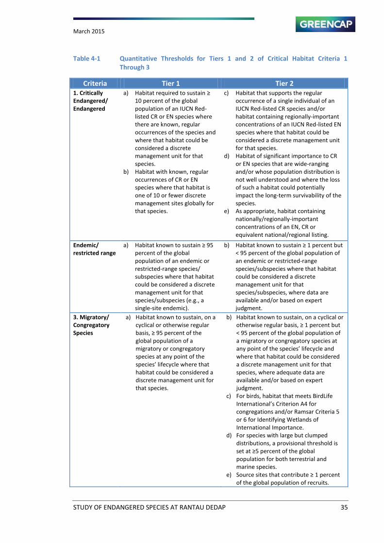
March 2015
STUDY OF ENDANGERED SPECIES AT RANTAU DEDAP 35
Table 4-1 Quantitative Thresholds
for Tiers 1 and 2 of Critical Habitat Criteria 1
Through 3
Criteria Tier 1 Tier 2
1. Critically
Endangered/
Endangered
a) Habitat required to sustain ≥ 10 percent of the global
population of an IUCN Red-
listed CR or EN species where
there are known, regular
occurrences of the species and
where that habitat could be
considered a discrete
management unit for that
species.
b) Habitat with known, regular
occurrences of CR or EN
species where that habitat is
one of 10 or fewer discrete
management sites globally for
that species.
c) Habitat that supports the regular
occurrence of a single individual of an
IUCN Red-listed CR species and/or
habitat containing regionally-important
concentrations of an IUCN Red-listed EN
species where that habitat could be
considered a discrete management unit
for that species.
d) Habitat of significant importance to CR
or EN species that are wide-ranging
and/or whose population distribution is
not well understood and where the loss
of such a habitat could potentially
impact the long-term survivability of the
species.
e) As appropriate, habitat containing
nationally/regionally-important
concentrations of an EN, CR or
equivalent national/regional listing.
Endemic/
restricted range
a) Ha itat k o to sustai ≥ 9 percent of the global
population of an endemic or
restricted-range species/
subspecies where that habitat
could be considered a discrete
management unit for that
species/subspecies (e.g., a
single-site endemic).
b) Ha itat k o to sustai ≥ per e t ut < 95 percent of the global population of
an endemic or restricted-range
species/subspecies where that habitat
could be considered a discrete
management unit for that
species/subspecies, where data are
available and/or based on expert
judgment.
3. Migratory/
Congregatory
Species
a) Habitat known to sustain, on a
cyclical or otherwise regular
asis, ≥ 9 per e t of the global population of a
migratory or congregatory
species at any point of the
spe ies life y le here that habitat could be considered a
discrete management unit for
that species.
b) Habitat known to sustain, on a cyclical or
other ise regular asis, ≥ per e t ut < 95 percent of the global population of
a migratory or congregatory species at
a y poi t of the spe ies life y le a d where that habitat could be considered
a discrete management unit for that
species, where adequate data are
available and/or based on expert
judgment.
c) For birds, habitat that meets BirdLife
I ter atio al s Criterio A for congregations and/or Ramsar Criteria 5
or 6 for Identifying Wetlands of
International Importance.
d) For species with large but clumped
distributions, a provisional threshold is
set at ≥ per e t of the glo al population for both terrestrial and
marine species.
e) “our e sites that o tri ute ≥ per e t of the global population of recruits.
March 2015
STUDY OF ENDANGERED SPECIES AT RANTAU DEDAP 36
4.1.5. Legally Protected Areas
In circumstances where a proposed project is located within a legally protected area,
SERD, in addition to the applicable requirements of paragraph 10 above, will meet the
following requirements:
Act in a manner consistent with defined protected area management plans
Consult protected area sponsors and managers, local communities, and other key
stakeholders on the proposed project
Implement additional programs, as appropriate, to promote and enhance the
conservation aims of the protected area
4.1.6. Invasive Alien Species
Intentional or accidental introduction of alien, or non-native, species of flora and fauna
into areas where they are not normally found can be a significant threat to biodiversity,
since some alien species can become invasive, spreading rapidly and out-competing
native species.
SERD will not intentionally introduce any new alien species (not currently established in
the country or region of the project) unless this is carried out in accordance with the
existing regulatory framework for such introduction, if such framework is present, or is
subject to a risk assessment (as part of the SERD s “o ial a d E iro e tal
Assessment) to determine the potential for invasive behavior. SERD will not deliberately
introduce any alien species with a high risk of invasive behavior or any known invasive
species, and will exercise diligence to prevent accidental or unintended introductions.
4.1.7. Mitigation Hierarchy
The o ser atio a tio s ha e ee esta lished ith the ai of a hie i g o et loss to
biodiversity in accordance with IFC PS6 (IFC, 2012a, 2012b). IFC PS6 requires evidence that the
mitigation hierarchy has been applied, that avoidance is prioritized, and that offsets are
measurable and only applied as a last resort where residual impacts are unavoidable.
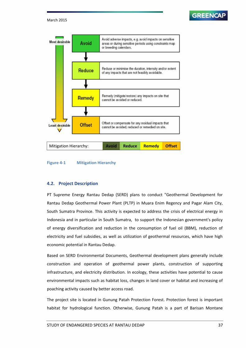
March 2015
STUDY OF ENDANGERED SPECIES AT RANTAU DEDAP 37
Mitigation Hierarchy: Avoid Reduce Remedy Offset
Figure 4-1 Mitigation Hierarchy
4.2. Project Description
PT Supreme Energy Rantau Dedap (SERD) plans to conduct "Geothermal Development for
Rantau Dedap Geothermal Power Plant (PLTP) in Muara Enim Regency and Pagar Alam City,
South Sumatra Province. This activity is expected to address the crisis of electrical energy in
Indonesia and in particular in South Sumatra, to support the Indonesian government's policy
of energy diversification and reduction in the consumption of fuel oil (BBM), reduction of
electricity and fuel subsidies, as well as utilization of geothermal resources, which have high
economic potential in Rantau Dedap.
Based on SERD Environmental Documents, Geothermal development plans generally include
construction and operation of geothermal power plants, construction of supporting
infrastructure, and electricity distribution. In ecology, these activities have potential to cause
environmental impacts such as habitat loss, changes in land cover or habitat and increasing of
poaching activity caused by better access road.
The project site is located in Gunung Patah Protection Forest. Protection forest is important
habitat for hydrological function. Otherwise, Gunung Patah is a part of Barisan Montane
March 2015
STUDY OF ENDANGERED SPECIES AT RANTAU DEDAP 38
Ranges that is spread from north to the south of Sumatra and one of important habitat for the
remaining endangered wildlife in Sumatra. Some protected species use this area as a habitat,
one of which is the Sumatran Tiger.
GREENCAP (ENV) has conducted a study with background as described in the INTRODUCTION
chapter. Stages of studies that have been done are literature review, field observation and
monitoring using camera traps (October-January). From eight of the target species, five species
have been proved for their existence in the project site. In addition, observations were also
recorded three other threatened species. This wildlife study is focused on mammals.
The determination of critical habitat was only used five biological criteria. The unit analysis or
focused area for this critical habitat assessment is defined based on impacted area of project.
The observation was using seven triggering species for project area which consist of two
primates and five species of IUCN Red List threatened large mammals based on field
observation. Siamang and Sumatran Surili are primate species, and Sunda Pangolin, Sumatran
Tiger, Dhole, Malayan Sunbear, Malayan Tapir and Serow for large mammals.
4.3. Critical Habitat Assessment
In order to conduct a CHA, a discrete management unit (DMU) (i.e. the geographic area which
is being investigated) must be defined with regard to criteria 1 to 3 (IFC, 2012b).
Spatial scope and unit analysis will use natural boundaries, which is hydrological catchment.
Analysis focused on catchment that impacted by project. For the landscape, focused area is
edge habitat of Bukit Barisan Landscape of Sumatera. The species that have been used for
reference are consist of two Critical Endangered, four Endangered, and one Vulnerable based
on the IUCN red list, but it has restricted range. All of them are mammals which are found in
the Project area.
4.3.1. Criteria 1 and 2: Critically Endangered and Endangered Species; and Endemic and
Restricted-range Species
Based on screening, detailed field survey and monitoring were recorded seven species as
trigger of critical habitat under criterion 1 and/or 2. Table 4-2 is species that include on criteria
1 and/or 2 of critical habitat. Table 4-2 is list of trigger species of Critical Habitat Assessment.
Critical habitat assessment conducted throughout the species triggered by determining the key
species. That is because the focus area and the area impacted by project is not too widely.
Based on expert judgment, Tiger is specified as key species of ecology. Potential habitat of
March 2015
STUDY OF ENDANGERED SPECIES AT RANTAU DEDAP 39
tiger is approached with the prey findings in the study area. Spatial analysis performed using
the software MAXENT, it was presented in detail in Chapter Habitat Modeling. The result of
spatial analysis is Critical Habitat Tier 2 of Project Area.
4.3.2. Criteria 3: Concentrations of Migratory and Congregatory Species;
Survey did not record of migratory species on project location. No trigger species of critical
habitat at these criteria.
4.3.3. Criteria 4 and 5: Highly-threatened and Unique Ecosystems; and
Habitat and ecosystem as discussed on chapter Vegetation and Ecosystem. Most of focused
area is Montane Forest Ecosystem. Project area included Sumatran montane rain forests eco
region. Ecosystem types are quite common and can be found on Southern Sumatra Island.
It thus does not trigger Critical Habitat for Highly-threatened and unique ecosystems.
4.3.4. Criteria 5: Key Evolutionary Processes
This unit of analysis does not appear to have been the subject of the significant evolutionary
processes required to meet this criterion. It is representative of a much broader and relatively
homogenous landscape with low endemism. It thus does not trigger Critical Habitat for key
evolutionary processes.
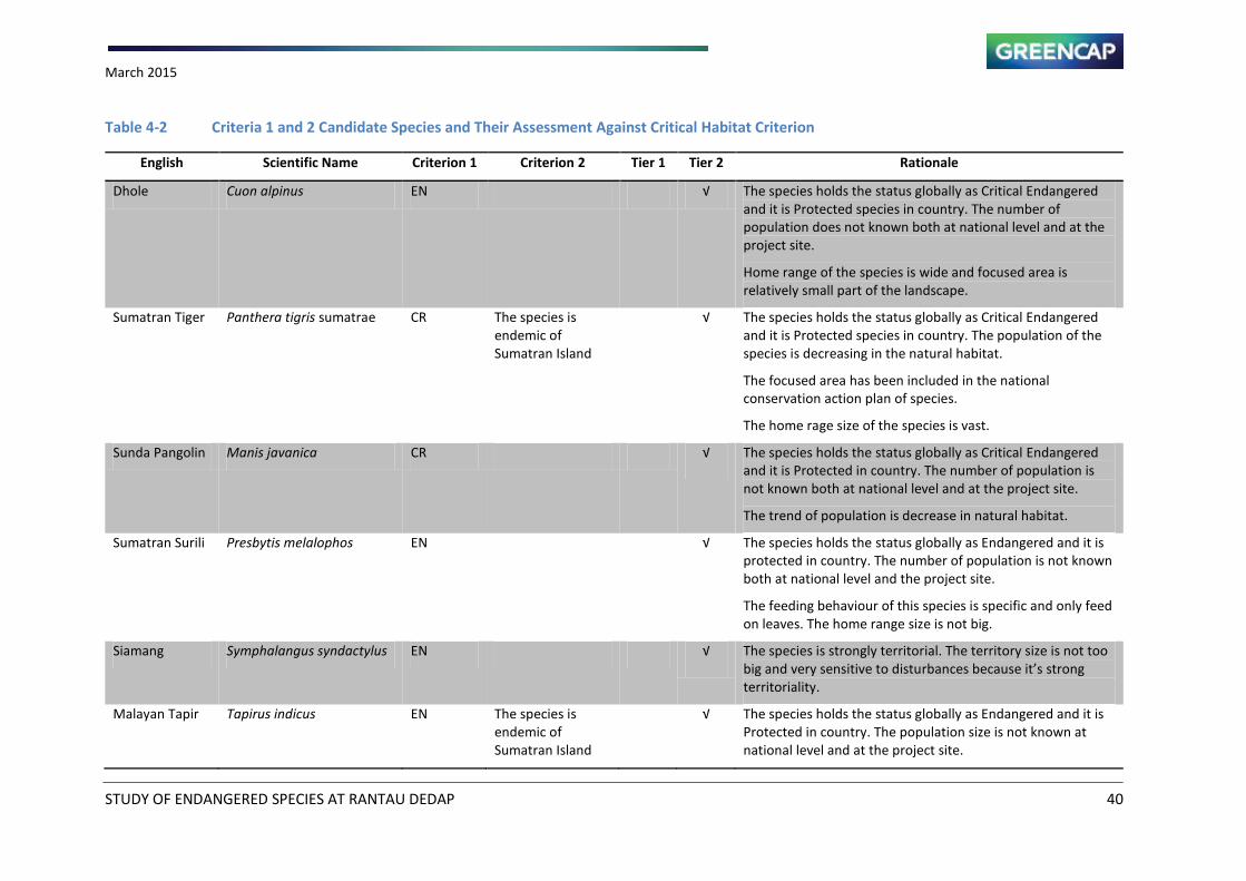
March 2015
STUDY OF ENDANGERED SPECIES AT RANTAU DEDAP 40
Table 4-2 Criteria 1 and 2 Candidate Species and Their Assessment Against Critical Habitat Criterion
English Scientific Name Criterion 1 Criterion 2 Tier 1 Tier 2 Rationale
Dhole Cuon alpinus EN √ The species holds the status globally as Critical Endangered
and it is Protected species in country. The number of
population does not known both at national level and at the
project site.
Home range of the species is wide and focused area is
relatively small part of the landscape.
Sumatran Tiger Panthera tigris sumatrae CR The species is
endemic of
Sumatran Island
√ The species holds the status globally as Critical Endangered
and it is Protected species in country. The population of the
species is decreasing in the natural habitat.
The focused area has been included in the national
conservation action plan of species.
The home rage size of the species is vast.
Sunda Pangolin Manis javanica CR √ The species holds the status globally as Critical Endangered
and it is Protected in country. The number of population is
not known both at national level and at the project site.
The trend of population is decrease in natural habitat.
Sumatran Surili Presbytis melalophos EN √ The species holds the status globally as Endangered and it is
protected in country. The number of population is not known
both at national level and the project site.
The feeding behaviour of this species is specific and only feed
on leaves. The home range size is not big.
Siamang Symphalangus syndactylus EN √ The species is strongly territorial. The territory size is not too
ig a d ery se siti e to distur a es e ause it s stro g territoriality.
Malayan Tapir Tapirus indicus EN The species is
endemic of
Sumatran Island
√ The species holds the status globally as Endangered and it is
Protected in country. The population size is not known at
national level and at the project site.
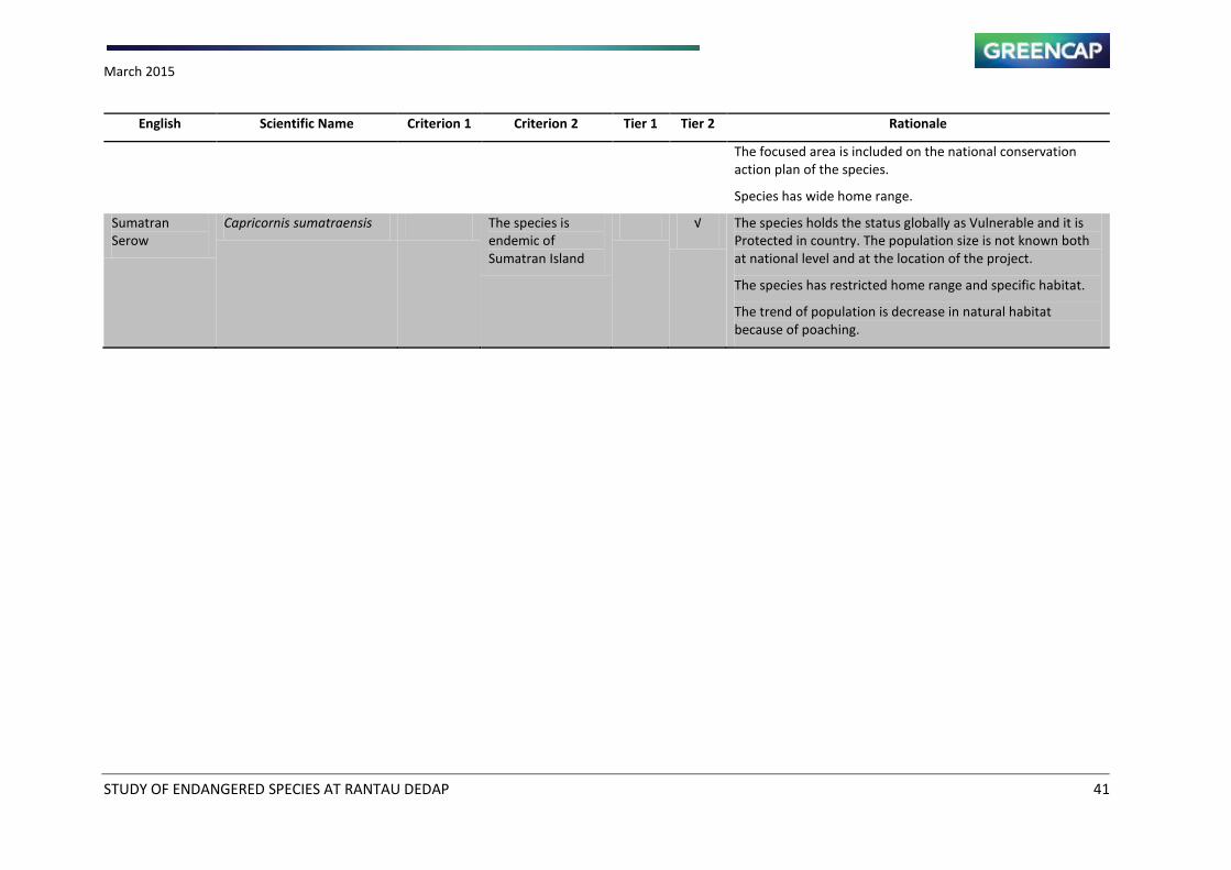
March 2015
STUDY OF ENDANGERED SPECIES AT RANTAU DEDAP 41
English Scientific Name Criterion 1 Criterion 2 Tier 1 Tier 2 Rationale
The focused area is included on the national conservation
action plan of the species.
Species has wide home range.
Sumatran
Serow
Capricornis sumatraensis The species is
endemic of
Sumatran Island
√ The species holds the status globally as Vulnerable and it is
Protected in country. The population size is not known both
at national level and at the location of the project.
The species has restricted home range and specific habitat.
The trend of population is decrease in natural habitat
because of poaching.
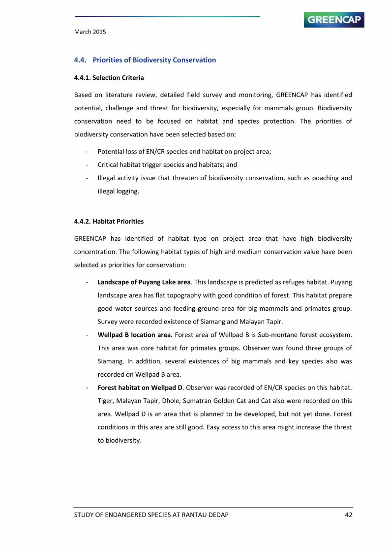
March 2015
STUDY OF ENDANGERED SPECIES AT RANTAU DEDAP 42
4.4. Priorities of Biodiversity Conservation
4.4.1. Selection Criteria
Based on literature review, detailed field survey and monitoring, GREENCAP has identified
potential, challenge and threat for biodiversity, especially for mammals group. Biodiversity
conservation need to be focused on habitat and species protection. The priorities of
biodiversity conservation have been selected based on:
- Potential loss of EN/CR species and habitat on project area;
- Critical habitat trigger species and habitats; and
- Illegal activity issue that threaten of biodiversity conservation, such as poaching and
illegal logging.
4.4.2. Habitat Priorities
GREENCAP has identified of habitat type on project area that have high biodiversity
concentration. The following habitat types of high and medium conservation value have been
selected as priorities for conservation:
- Landscape of Puyang Lake area. This landscape is predicted as refuges habitat. Puyang
landscape area has flat topography with good condition of forest. This habitat prepare
good water sources and feeding ground area for big mammals and primates group.
Survey were recorded existence of Siamang and Malayan Tapir.
- Wellpad B location area. Forest area of Wellpad B is Sub-montane forest ecosystem.
This area was core habitat for primates groups. Observer was found three groups of
Siamang. In addition, several existences of big mammals and key species also was
recorded on Wellpad B area.
- Forest habitat on Wellpad D. Observer was recorded of EN/CR species on this habitat.
Tiger, Malayan Tapir, Dhole, Sumatran Golden Cat and Cat also were recorded on this
area. Wellpad D is an area that is planned to be developed, but not yet done. Forest
conditions in this area are still good. Easy access to this area might increase the threat
to biodiversity.
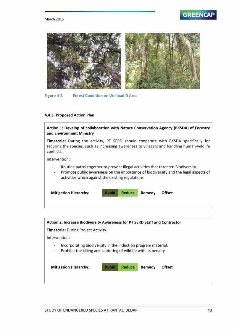
March 2015
STUDY OF ENDANGERED SPECIES AT RANTAU DEDAP 43
Figure 4-2 Forest Condition on Wellpad D Area
4.4.3. Proposed Action Plan
Action 1: Develop of collaboration with Nature Conservation Agency (BKSDA) of Forestry
and Environment Ministry
Timescale: During the activity, PT SERD should cooperate with BKSDA specifically for
securing the species, such as increasing awareness to villagers and handling human-wildlife
conflicts.
Intervention:
- Routine patrol together to prevent illegal activities that threaten Biodiversity.
- Promote public awareness on the importance of biodiversity and the legal aspects of
activities which against the existing regulations.
Mitigation Hierarchy: Avoid Reduce Remedy Offset
Action 2: Increase Biodiversity Awareness for PT SERD Staff and Contractor
Timescale: During Project Activity.
Intervention:
- Incorporating biodiversity in the induction program material.
- Prohibit the killing and capturing of wildlife with its penalty
Mitigation Hierarchy: Avoid Reduce Remedy Offset
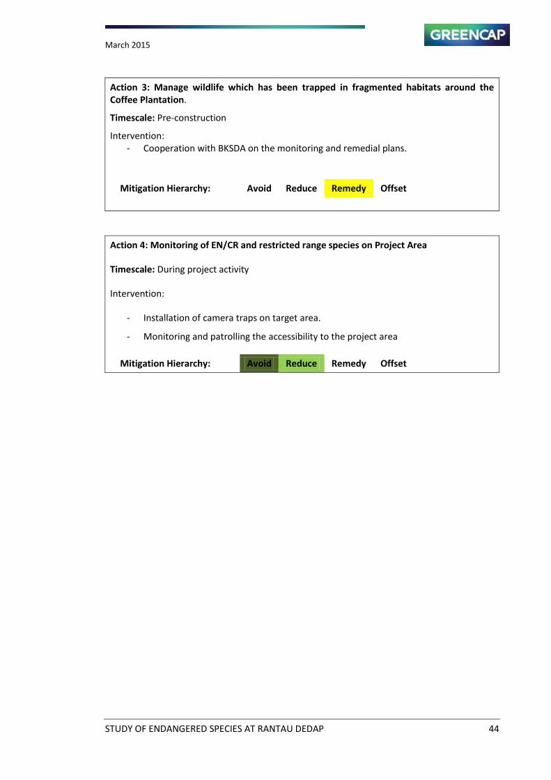
March 2015
STUDY OF ENDANGERED SPECIES AT RANTAU DEDAP 44
Action 3: Manage wildlife which has been trapped in fragmented habitats around the
Coffee Plantation.
Timescale: Pre-construction
Intervention:
- Cooperation with BKSDA on the monitoring and remedial plans.
Mitigation Hierarchy: Avoid Reduce Remedy Offset
Action 4: Monitoring of EN/CR and restricted range species on Project Area
Timescale: During project activity
Intervention:
- Installation of camera traps on target area.
- Monitoring and patrolling the accessibility to the project area
Mitigation Hierarchy: Avoid Reduce Remedy Offset
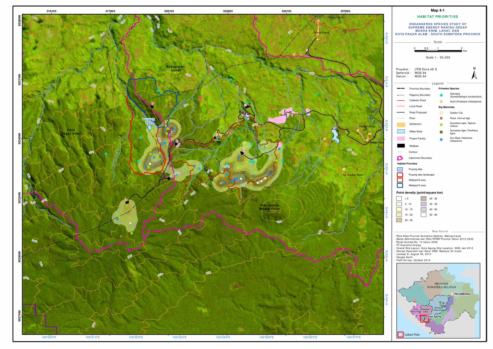
HABI TAT PRI ORI TI ES
- Peta Atlas Provinsi Sumatera Selatan, Bakosurtanal
- Batas Adm inist rasi dari Peta RTRW Provinsi Tahun 2012-2032
Perda Sumsel No. 14 tahun 2006
- PT Supreme Energy
- Overal Site Layout , Kota Agung Site Locat ion, SKM, Jan 2012
- Elevasi Diperoleh dar i Aster DEM, Resolusi 30 meter
- Landsat 8, August 08, 2013
- Google Ear th
- Field Survey, October 2014
Scale
Legend
Map Source
! !!
!
! !
!
!
!
!!
! !!!
!!
!
!
!!
!
!
!
! !
!
!
!
!
!
!
!
!
!!
!
!
!
!
!
!
!
!!
!
!
!!!
!!
!
!
!
!
!
!
!
!
!
!
!
!
!
!
!
!
!
!H
PROVINSI
SUMATERA SELATAN
PALEMBANG
Kota Agung
Kota
Pagar AlamKabupaten
Lahat
Kabupaten
Muara Enim
Lokasi Peta
Province Boundary
Regency Boundary
Collector Road
Local Road
Road Proposed
Water Body
Settlement
Project Facility
Wellpad
ENDANGERED SPECIES STUDY OFSUPREME ENERGY RANTAU DEDAP
MUARA ENIM, LAHAT, DAN KOTA PAGAR ALAM - SOUTH SUMATERA PROVINCE
Proyeksi :
Spheroid :
Datum :
UTM Zona 48 S
WGS 84
WGS 84
"/
!
!
!
!
!
!!!
!!
!
!
!!
!
!!!
!
!!!
!!!!!
!
!
!!!!!
!
!!!!
!!!
(
(
(
(
(
(((
((
(
(
((
(
(((
(
(((
(((((
(
(
(((((
(
((((
((("""""
" "
"
)))))
) )
)!
!
!!
!!!!
!
!
!!
!!!
!
!
!!!
!
!
!!
!
!!!!!
!
!!
!
!
!!
!!!!
!!
!!
!!
(
(
((
((((
(
(
((
(((
(
(
(((
(
(
((
(
(((((
(
((
(
(
((
((((
((
((
((
!(
!!
!
!
!!
!!!
!(
(
(
(
((
(((
(
!.
!.
!.
!.
!.
!.
!.
!.
!.
!.
!.
!.
!.
!.
!.
!.
!.
!.!.
!.
!.
A
B
G
C
D
Kabupaten Lahat
Kabupaten Muara Enim
Rantau Dedap
Talang Pisang
Tunggul Bute
Kp. Sumber Rejeki
I
Kamp. YayaE
Puyang Lake
KotaPagar Alam
2000
2400
1
200
14
0 0
1000
22 00
1800
2600
1600
2400
22
00
2200
140 0
1800
16
00
2 000
2
000
1600
2000
2200
1
600
18
00
2600
2000
2000
2200
2200
1 400
2000
140 0
2600
1000
1400
1200
14
00
140 01
000
2
400
18
00
1000
1000
18
00
12
00
1
200
20 0
0
2 0 00
1200
1200
2200
1400
14
00
2200
20 00
1800
S.
Asahan
S.E
ndik
atK
ana
n
S. Endikat
S.C
aw
an
gK
ir i
S. D
edap
an
S.C
aw
ang
T
engah
S. Air
Angat
2272
1991
1216
2050
2546
103°27'0"E103°26'0"E103°25'0"E103°24'0"E103°23'0"E103°22'0"E103°21'0"E103°20'0"E
4°1
0'0
"S4°1
1'0
"S4°1
2'0
"S4°1
3'0
"S4°1
4'0
"S4°1
5'0
"S4°1
6'0
"S
315103 317603 320103 322603 325103 327603
95274
96
95299
96
95324
96
95349
96
95374
96
95399
96
0 1 20.5Km
±U
Scale 1 : 50,000
Primates Species
!.Siamang(Symphalangus syndactylus)
!. Surili (Presbytis melalophos)
Big Mammals
!( Golden Cat
!( Rusa, Cervus spp.
!(Sumatran tapir, Tapirusindicus
")Sumatran tiger, Pantheratigris
!(Sun Bear, Helarctosmalayanus
River
Map 4-1
Contour
Catchment Boundary
Habitat Priorities
Puyang lake
Puyang lake landscape
Wellpad B area
Wellpad D area
Point density (point/square km)
< 5
5 - 10
10 - 15
15 - 20
20 - 25
25 - 30
30 - 40
40 - 50
50 - 60
March 2015
STUDY OF ENDANGERED SPECIES AT RANTAU DEDAP 46
CHAPTER 5 CONCLUSIONS
Based on the results of the field study in the Project area, Greencap suggests some
considerations and recommendations for actions to the SERD management.
1. Among the Critically Endangered and Endangered species found in the Project area are the
Sumatran tiger, Sunda pangolin, Dhole, Malayan tapir, Siamang, and Sumatran surili. The
finding of Sunda pangolin in the 1,910 m AMSL in the project area is the highest record in
terms of altitude where the species has ever found.
2. The Sumatran tiger in this area could be one population with those dispersed in Bukit
Barisan Selatan National Park (BBSNP). Male tigers can roam about three times farther
than females. The average dispersal distance for males is 33 km, and the longest is 65 km,
whereas female dispersal distances are less than 10 km, with the longest of 33 km (Smith,
1993).
3. The forest habitat in the Project region is situated in the northwest of the vast tiger habitat
in BBSNP. BBSNP has been categorized as the Tiger Conservation Unit I (TCU I) based on
the analysis of Wikramanyake, et al. (1999). The nearest distance to BBSNP is only 40 km
towards southeast, separated by high montane forests.
4. The Project area is covering about 120 km2. Only 91 hectares of the Project facility area is
located in the protection forest of Bukit Jambul - Gunung Patah, with elevations of 1,500
to 2,600 m AMSL -- relatively small for tiger habitat
5. Using the available references on the priority areas for conservation of tigers in the wild,
the forest habitat in the Project area is included to the TCU III (Wikramanayake, et al.,
1999). This means that the area has been considered less important in terms of the size of
the land area available for tigers. However, tigers can persist in relatively small protected
area, provided their prey base is protected and maintained at an adequate density
(Karanth and Stith, 1999). This might be the case with the tigers in the Project area.
6. The forest connection towards BBSNP might still function although very narrow. This forest
strip should be maintained and secured, particularly to protect prey species.
7. A decade ago, the forest habitat of the study area was included on the list of small
fragmented forest patches where Sumatran elephants could be found (Soehartono, et al.,
2007). However, this species is no longer exist. This might be due to human pressure which
caused to local extinction.
8. It has been shown by the data that a variety of prey species exist in the Project area such
as deer, tapir, and pigs. These are the favourite prey species for tigers.
March 2015
STUDY OF ENDANGERED SPECIES AT RANTAU DEDAP 47
9. Active animal traps and snares were found in the forest. It is important for the
management to work together with local conservation authority to develop monitoring
activities for controlling animal hunting.
10. Currently, the local people have not yet experienced with human-wildlife conflicts. It
indicates that the ecosystem chain of the forest habitat in the Project area is still relatively
good.
11. The Project area situated in high elevation of the sub-montane and montane forest
habitat. Among the gibbon species only Siamang is available in this type of habitat. Agile
gibbon does not exist because, they are more frugivorous.
12. Siamang is a territorial species. They are hardly to move even its surroundings are
disturbed. They will defend their territory until they are killed or captured. Since the
management only open the forest limited to the site where it is needed and maintain the
forest surroundings wellpad, control access road and other facilities secured, the species
does not move far away. Most important is to provide arboreal path way connection at the
certain points where the gaps less than 30 m available due to access road construction.
The connection may use rope which is made from natural materials.
13. The Sumatran surili is folivorous and it survives with less fruits. They did not raid the coffee
plantation adjacent to the forest area.
14. The Sumatran surili tends to live in the periphery forest habitat at lower elevation. It
probably in order to find more insects and young leaves because, more light enters these
spots which could produce many young leaves and attracts insects as well.
15. The Sumatran surili is not truly arboreal. They frequently move on the ground when
crossing the gap of forest. This primate species has been considered prey animals for the
big cats including the Sumatran tiger. Maintain this species is important in order to
diversify prey animals in the Project area.
March 2015
STUDY OF ENDANGERED SPECIES AT RANTAU DEDAP 48
REFERENCES
Gittins, S.P. 1979. The behavior and ecology of the agile gibbon (Hylobates agilis).
Unpublished phD thesis, University of Cambridge.
Hedges, S., M. J.Tyson, A.F. Sitompul, M. F. Kinnaird, D. Gunaryadi, & B. Aslan. 2005.
Distribution, status and conservation needs of Asian elephant (Elephas maximus)
in Lampung Province, Sumatra, Indonesia. Biological Conservation, 124:35-48.
International Finance Corporation. 2012a. PS 6: Biodiversity Conservation and Sustainable
Management of Living Natural Resources. World Bank Group, Washington, DC.
International Finance Corporation. 2012b. Guidance Note 6: Biodiversity Conservation and
Sustainable Management of Living Natural Resources. World Bank Group,
Washington, DC.
IUCN. 2015. IUCN Red List of Threatened Species. Available online at:
http://www.iucnredlist.org. Accessed February, 2015
Karanth, K.U and B.M. Stith, 1999 Prey depletion as a critical determinant of tiger population
viability. In The Tiger: Tiger Conservation in human dominated landscape (
J.Seidensticker, S. Christie, and P. Jackson, eds) pp.100-113. Cambridge
University Press, UK.
Linkie M, Martyr DJ, Holden J et al. 2003. Habitat destruction and poaching threaten the
Sumatran tiger in Kerinci Seblat National Park, Sumatra. Oryx 37: 41–8.
Martin, R.B. and T de Maulenaer, 1988 Survey of the status of the leopard (Panthera
pardus) in Sub Saharan Africa. Lausanne, Switzerland. CITES Secretariat.
No ak, ‘.M. a d Walker s, 999. Ma als of the orld. Vol , th ed. John Hopkins University
Press, Baltimore.
Nurcahyo, A. 2009. The Role of Plantations in the Conservation of Gibbons and other rimates,
Bukit Barisan Selatan Landscape, Sumatra, Indonesia. Unpublished thesis.
Australian National University,
Nugraha RT, Sugardjito, J. 2009. Assessment and management options of human–tiger
conflicts in Kerinci Seblat National Park, Sumatra, Indonesia. Mammal Study
34: 141–54.
March 2015
STUDY OF ENDANGERED SPECIES AT RANTAU DEDAP 49
O'Brien,T G., Kinnaird, M.F.,Nurcahyo, A., Iqbal, M., and Rusmato, M. 2004. Abundance and
Distribution of Sympatric Gibbons in a Threatened Sumatran Rain Forest. Int’l J.
Primatology, 25: 267-284.
O Brie T.G, Ki aird M.F, and Wibisono H.T 2003. Crouch-ing tiger, hidden prey: Sumatran
tiger and prey populations in a tropical forest landscape. Animal Conservation 6:
131–139.
Raemakers, J.J. 1984. Large versus Small Gibbons: Relative Roles of Bioenergetics and
Competition in their Ecological Segregation in Sympatry. In: The Lesser Apes.
Evolutionary and Behavioural Biology, Preuschoft, Chivers, Brockleman and
Creel, eds (pp 209 – 218). Ediburgh University Press.
Raemakers, J.J. 1977. Gibbons and trees: ecology of the siamang and lar gibbons.
Unpublished phD thesis, University of Cambridge.
Semiadi, G., D.Darnaedi, and A.J.Arief. 2009. Sunda Pagolin (Manis javanica) conservation in
Indonesia: Status and Problems. Proceedings Asian Pangolin Conservation
Workshop on Trade and Conservation of Pangolin Native to South and Souteast
Asia. Singapore Zoo & TRAFFIC Asia. Pp.12-17. Singapore 30 June- 2 July 2008.
Soehartono, T., Susilo, H.D., Sitompul, A.F., Gunaryadi, D., Purastuti, E.M., Azmi, W., Fadhli, N.,
and Stremme, C. 2007. The strategic and action plan for Sumatran and
Kalimantan elephant. Departemen Kehutanan, Jakarta. Indonesia.
Stabach, J. A; Nadine Laporte; and William Oiupot. Modeling habitat suitability for Grey
Crowned-cranes (Balearica regulorum gibbericeps) throughout Uganda.
International Journal of Biodiversity and Conservation Vol 1(5):177-186. Uganda.
2009
Wibisono, H.T., and Pusparini, W. (2010) Sumatran tiger (Panthera tigris sumatrae): A review
of conservation status. Integrative zoology 5: 313-323
Uryu, Y.; Mott, C.; Foead, N.; Yulianto, K.; Budiman, A.; Setiabudi; Takakai, F.;Nursamsu;
Sunarto; Purastuti, E.; Fadhli, N.; Hutajulu, C.; Jaenicke, J.; Hatano, R.; Siegert, F.;
Stüwe, M. Deforestation, Forest Degradation, Biodiversity Loss and CO2
Emissions in Riau Sumatra, Indonesia; WWF Indonesia Technical Report; WWF:
Jakarta, Indonesia, 2008.
March 2015
STUDY OF ENDANGERED SPECIES AT RANTAU DEDAP 50
Wikramanyake, E.D., E. Dinnerstein, J.C. Robinson; K.U.Karanth; A. Robinowitz; D. Olson, T.
Mathew; P. Hedao; M. Connor; G. Hemley; and D. Bolze al., 1999 Where can
tigers live in the future? A framework for identifying high-priority areas for the
conservation of tigers in the wild. In The Tiger: Tiger Conservation in human
dominated landscape ( J.Seidensticker, S. Christie, and P. Jackson, eds) pp.252-
272. Cambridge University Press, UK.
Wirdateti; Yulianto; and G.Semiadi. 2013. Distribution and Habitat of Sunda Pangolin (Manis
javanica Desmarest, 1822) in the districts of Tanggamus and West Lampung,
Lampung Province. Proceedings Seminar Nasional Biodiversitas, 2: 181-186 (in
Bahasa Indonesia)
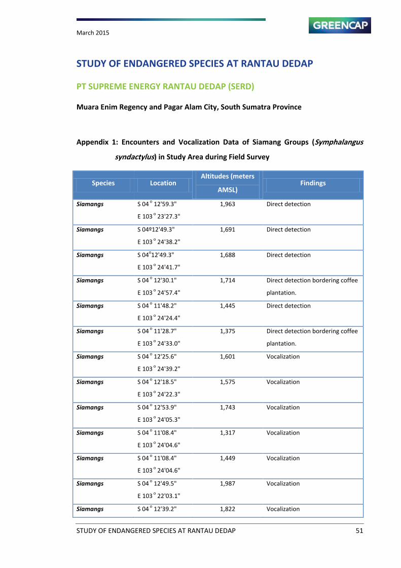
March 2015
STUDY OF ENDANGERED SPECIES AT RANTAU DEDAP 51
STUDY OF ENDANGERED SPECIES AT RANTAU DEDAP
PT SUPREME ENERGY RANTAU DEDAP (SERD)
Muara Enim Regency and Pagar Alam City, South Sumatra Province
Appendix 1: Encounters and Vocalization Data of Siamang Groups (Symphalangus
syndactylus) in Study Area during Field Survey
Species Location Altitudes (meters
AMSL) Findings
Siamangs S 04 o
12'59.3"
E 103 o
23'27.3"
1,963 Direct detection
Siamangs S 04º12'49.3"
E 103 o
24'38.2"
1,691 Direct detection
Siamangs S 04o12'49.3"
E 103 o
24'41.7"
1,688 Direct detection
Siamangs S 04 o
12'30.1"
E 103 o
24'57.4"
1,714 Direct detection bordering coffee
plantation.
Siamangs S 04 o
11'48.2"
E 103 o
24'24.4"
1,445 Direct detection
Siamangs S 04 o
11'28.7"
E 103 o
24'33.0"
1,375 Direct detection bordering coffee
plantation.
Siamangs S 04 o
12'25.6"
E 103 o
24'39.2"
1,601 Vocalization
Siamangs S 04 o
12'18.5"
E 103 o
24'22.3"
1,575 Vocalization
Siamangs S 04 o
12'53.9"
E 103 o
24'05.3"
1,743 Vocalization
Siamangs S 04 o
11'08.4"
E 103 o
24'04.6"
1,317 Vocalization
Siamangs S 04 o
11'08.4"
E 103 o
24'04.6"
1,449 Vocalization
Siamangs S 04 o
12'49.5"
E 103 o
22'03.1"
1,987 Vocalization
Siamangs S 04 o
12'39.2" 1,822 Vocalization
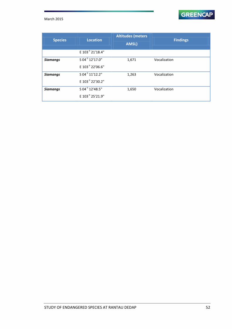
March 2015
STUDY OF ENDANGERED SPECIES AT RANTAU DEDAP 52
Species Location Altitudes (meters
AMSL) Findings
E 103 o
21'18.4"
Siamangs S 04 o
12'17.0"
E 103 o
22'06.6"
1,671 Vocalization
Siamangs S 04 o
11'12.2"
E 103 o
22'30.2"
1,263 Vocalization
Siamangs S 04 o
12'48.5"
E 103 o
25'21.9"
1,650 Vocalization
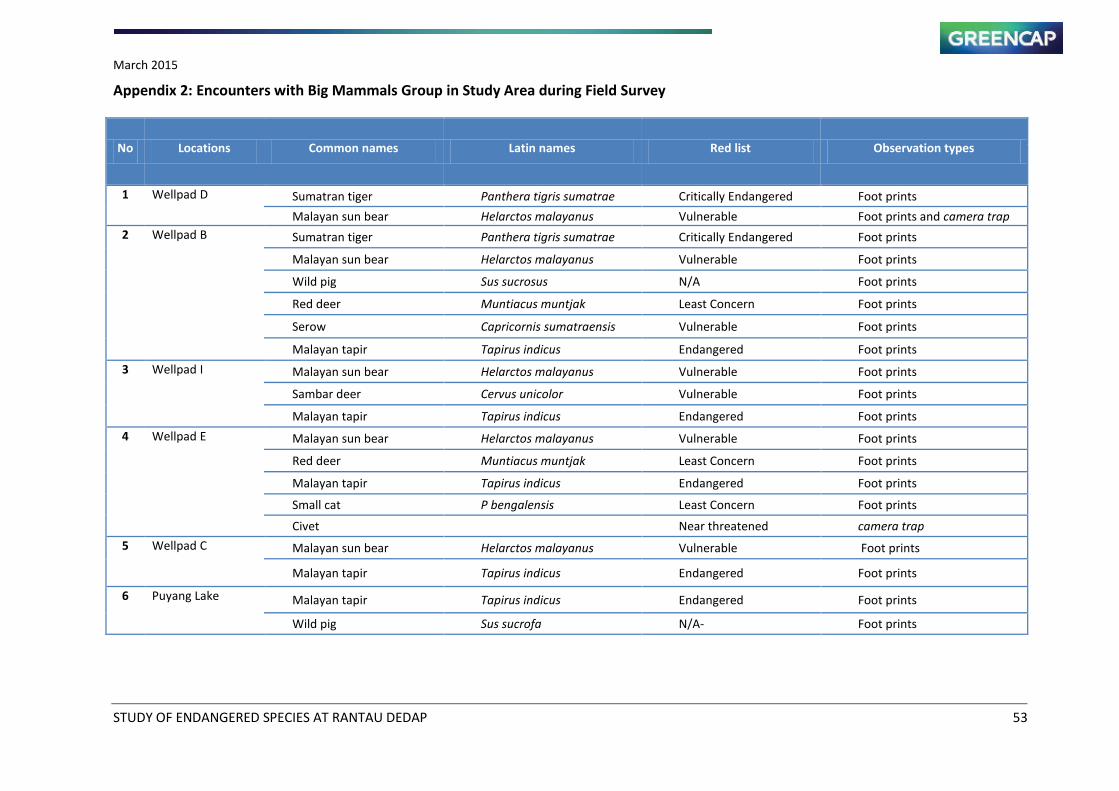
March 2015
STUDY OF ENDANGERED SPECIES AT RANTAU DEDAP 53
Appendix 2: Encounters with Big Mammals Group in Study Area during Field Survey
No Locations Common names Latin names Red list Observation types
1 Wellpad D Sumatran tiger Panthera tigris sumatrae Critically Endangered Foot prints
Malayan sun bear Helarctos malayanus Vulnerable Foot prints and camera trap
2
Wellpad B
Sumatran tiger Panthera tigris sumatrae Critically Endangered Foot prints
Malayan sun bear Helarctos malayanus Vulnerable Foot prints
Wild pig Sus sucrosus N/A Foot prints
Red deer Muntiacus muntjak Least Concern Foot prints
Serow Capricornis sumatraensis Vulnerable Foot prints
Malayan tapir Tapirus indicus Endangered Foot prints
3
Wellpad I Malayan sun bear Helarctos malayanus Vulnerable Foot prints
Sambar deer Cervus unicolor Vulnerable Foot prints
Malayan tapir Tapirus indicus Endangered Foot prints
4
Wellpad E Malayan sun bear Helarctos malayanus Vulnerable Foot prints
Red deer Muntiacus muntjak Least Concern Foot prints
Malayan tapir Tapirus indicus Endangered Foot prints
Small cat P bengalensis Least Concern Foot prints
Civet
Near threatened camera trap
5
Wellpad C
Malayan sun bear Helarctos malayanus Vulnerable Foot prints
Malayan tapir Tapirus indicus Endangered Foot prints
6 Puyang Lake Malayan tapir Tapirus indicus Endangered Foot prints
Wild pig Sus sucrofa N/A- Foot prints
March 2015
STUDY OF ENDANGERED SPECIES AT RANTAU DEDAP 54
Appendix 3: Input Environmental Variable Data of MaxEnt Habitat Modeling
Response of Prey Species Distribution to Environmental Variables
March 2015
STUDY OF ENDANGERED SPECIES AT RANTAU DEDAP 55
March 2015
STUDY OF ENDANGERED SPECIES AT RANTAU DEDAP 56
DI STANCE FROM W ATER SOURCES
VARI ABLE OF MAXENT MODEL
- Peta At las Provinsi Sum atera Selatan, Bakosur tanal
- Batas Adm inist rasi dar i Peta RTRW Provinsi
Tahun 2012-2032 Perda Sum sel No. 14 tahun 2006
- PT Suprem e Energy
- Overal Si te Layou t , Kota Agung Site Locat ion, SKM,
Jan 2012
- Elevasi Diperoleh dar i Aster DEM, Resolusi 30 m eter
- Landsat 8 , May, 2014
- Google Ear th
- Field Survey, October 2014
Sca le
Lege nd
Ma p Source
! !!
!
! !
!
!
!
!!
!!!!
!
!
!
!
!
!
! !
!
!
!
!
!
!
!
!
!
!
!
!
!
!
!
!
!!!
!!
!
!
!
!
!
!
!
!
!
!
!
!
!
!H
PROVINSI
SUMATERA SELATAN
PALEMBANG
Kota Agung
Kota
Pagar Alam
Kabupaten
Lahat
Kabupaten
Muara Enim
Lokasi Peta
Province Boundary
Regency Boundary
Collector Road
Local Road
Road Proposed
EN D AN GE RE D S PE CIES STU D Y OFSU PR E ME EN E RGY R A NTA U D ED A P
MU AR A EN IM , LA H AT, D A N KOTA PA GA R A LA M
SOU TH S U MATE RA PR OV IN C E
Proyeksi :
Spheroid :
Datum :
UTM Zona 48 S
WGS 84
WGS 84
"/
!(
!(
!(
!(
!(
!(
!(
!(
!(
!(
!(
!(
!(
A
B
G
C
D
Rantau Dedap
Talang Pisang
Tunggul Bute
Patal
Kp. Sumber Rejeki
I
Kamp. YayasanE
Kabupaten Lahat
Kabupaten Muara Enim
KotaPagar Alam
Pro
vin
si S
um
ate
ra S
ela
tan
Pro
vin
si B
en
gk
ulu
AQN-5
TC-2
S.
Asa
han
S.
Endik
atK
anan
S. Endikat
S. D
edap
an
S. C
awan
g Te
ngah
S. Air
Angat
978885
2272
1991
1216
2326
1714
2050
1502
1840
2666
2546
1019
S. C
aw
ang K
iri
103°25'0"E103°20'0"E
4°5
'0"S
4°1
0'0
"S4°1
5'0
"S
310000 315000 320000 325000 330000
95
25
00
095
30
00
095
35
00
095
40
00
095
45
00
0
0 2 41Km
±U
Scale 1 : 125 ,000
W at ersource Distance Class ( m eters)
Class: 1 (0 - 500)
Class: 2 (500 - 1000)
Class: 3 (1000 - 1500)
Class: 4 (1500 - 2000)
Class: 5 (2000 - 2500)
Class: 6 (2500 - 3000)
Class: 7 (> 3000)
River
Wilayah Ker j a Pertam bangan ( WKP)
Study Area of Habitat Modeling
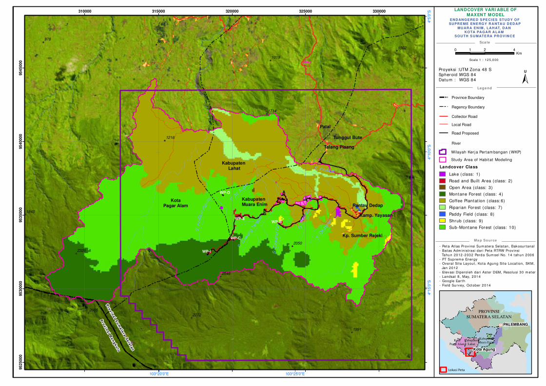
LANDCOVER VARI ABLE OF
MAXENT MODEL
- Peta At las Provinsi Sum atera Selatan, Bakosur tanal
- Batas Adm inist rasi dar i Peta RTRW Provinsi
Tahun 2012-2032 Perda Sum sel No. 14 tahun 2006
- PT Suprem e Energy
- Overal Si te Layou t , Kota Agung Site Locat ion, SKM,
Jan 2012
- Elevasi Diperoleh dar i Aster DEM, Resolusi 30 m eter
- Landsat 8 , May, 2014
- Google Ear th
- Field Survey, October 2014
Sca le
Lege nd
Ma p Source
! !!
!
! !
!
!
!
!!
!!!!
!
!
!
!
!
!
! !
!
!
!
!
!
!
!
!
!
!
!
!
!
!
!
!
!!!
!!
!
!
!
!
!
!
!
!
!
!
!
!
!
!H
PROVINSI
SUMATERA SELATAN
PALEMBANG
Kota Agung
Kota
Pagar Alam
Kabupaten
Lahat
Kabupaten
Muara Enim
Lokasi Peta
Province Boundary
Regency Boundary
Collector Road
Local Road
Road Proposed
EN D AN GE RE D S PE CIES STU D Y OFSU PR E ME EN E RGY R A NTA U D ED A P
MU AR A EN IM , LA H AT, D A N KOTA PA GA R A LA M
SOU TH S U MATE RA PR OV IN C E
Proyeksi :
Spheroid :
Datum :
UTM Zona 48 S
WGS 84
WGS 84
"/
!(
!(
!(
!(
!(
!(
!(
!(
!(
!(
!(
!(
!(
A
WP-B
G
WP-C
WP-D
Rantau Dedap
Talang Pisang
Tunggul Bute
Patal
Kp. Sumber Rejeki
WP-I
Kamp. YayasanWP-E
Kabupaten Lahat
Kabupaten Muara Enim
KotaPagar Alam
Pro
vin
si S
um
ate
ra S
ela
tan
Pro
vin
si B
en
gk
ulu
AQN-5
TC-2
S.
Asa
han
S.
Endik
atK
anan
S. Endikat
S. D
edap
an
S. C
awan
g Te
ngah
S. Air
Angat
978885
2272
1991
1216
2326
1714
2050
1502
1840
2666
2546
1019
S. C
aw
ang K
iri
103°25'0"E103°20'0"E
4°5
'0"S
4°1
0'0
"S4°1
5'0
"S
310000 315000 320000 325000 330000
95
25
00
095
30
00
095
35
00
095
40
00
095
45
00
0
0 2 41Km
±U
Scale 1 : 12 5,0 00
Landcover Class
Lake ( class: 1)
Road and Built Area (class: 2)
Open Area (class: 3)
Montane Forest ( class: 4)
Coffee Plantat ion ( class: 6)
Ripar ian Forest ( class: 7)
Paddy Field (class: 8)
Shrub ( class: 9)
Sub-Montane Forest (class: 10)
River
Wilayah Ker j a Pertam bangan ( WKP)
Study Area of Habitat Modeling
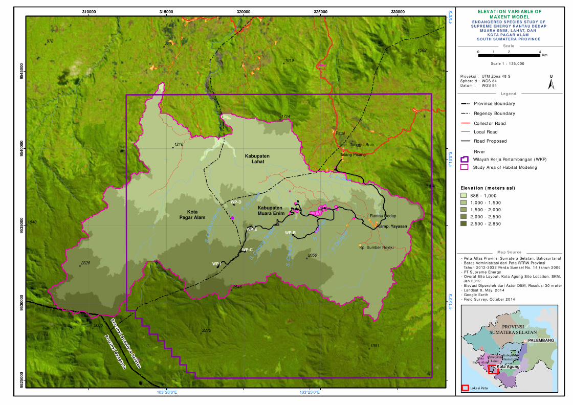
ELEVATI ON VARI ABLE OF
MAXENT MODEL
- Peta At las Provinsi Sum atera Selatan, Bakosur tanal
- Batas Adm inist rasi dar i Peta RTRW Provinsi
Tahun 2012-2032 Perda Sum sel No. 14 tahun 2006
- PT Suprem e Energy
- Overal Si te Layou t , Kota Agung Site Locat ion, SKM,
Jan 2012
- Elevasi Diperoleh dar i Aster DEM, Resolusi 30 m eter
- Landsat 8 , May, 2014
- Google Ear th
- Field Survey, October 2014
Sca le
Lege nd
Ma p Source
! !!
!
! !
!
!
!
!!
!!!!
!
!
!
!
!
!
! !
!
!
!
!
!
!
!
!
!
!
!
!
!
!
!
!
!!!
!!
!
!
!
!
!
!
!
!
!
!
!
!
!
!H
PROVINSI
SUMATERA SELATAN
PALEMBANG
Kota Agung
Kota
Pagar Alam
Kabupaten
Lahat
Kabupaten
Muara Enim
Lokasi Peta
Province Boundary
Regency Boundary
Collector Road
Local Road
Road Proposed
EN D AN GE RE D S PE CIES STU D Y OFSU PR E ME EN E RGY R A NTA U D ED A P
MU AR A EN IM , LA H AT, D A N KOTA PA GA R A LA M
SOU TH S U MATE RA PR OV IN C E
Proyeksi :
Spheroid :
Datum :
UTM Zona 48 S
WGS 84
WGS 84
"/
!(
!(
!(
!(
!(
!(
!(
!(
!(
!(
!(
!(
!(
A
WP-B
G
WP-C
WP-D
Rantau Dedap
Talang Pisang
Tunggul Bute
Patal
Kp. Sumber Rejeki
WP-I
Kamp. YayasanWP-E
Kabupaten Lahat
Kabupaten Muara Enim Kota
Pagar Alam
Pro
vin
si S
um
ate
ra S
ela
tan
Pro
vin
si B
en
gk
ulu
AQN-5
TC-2
S.
Asa
han
S.
Endik
atK
anan
S. Endikat
S. D
edap
an
S. C
awan
g Te
ngah
S. Air
Angat
978885
2272
1991
1216
2326
1714
2050
1502
1840
2666
2546
1019
S. C
aw
ang K
iri
103°25'0"E103°20'0"E
4°5
'0"S
4°1
0'0
"S4°1
5'0
"S
310000 315000 320000 325000 330000
95
25
00
095
30
00
095
35
00
095
40
00
095
45
00
0
0 2 41Km
±U
Scale 1 : 125 ,000
Elevat ion ( m et ers asl)
886 - 1,000
1,000 - 1,500
1,500 - 2,000
2,000 - 2,500
2,500 - 2,850
River
Wilayah Ker j a Pertam bangan ( WKP)
Study Area of Habitat Modeling
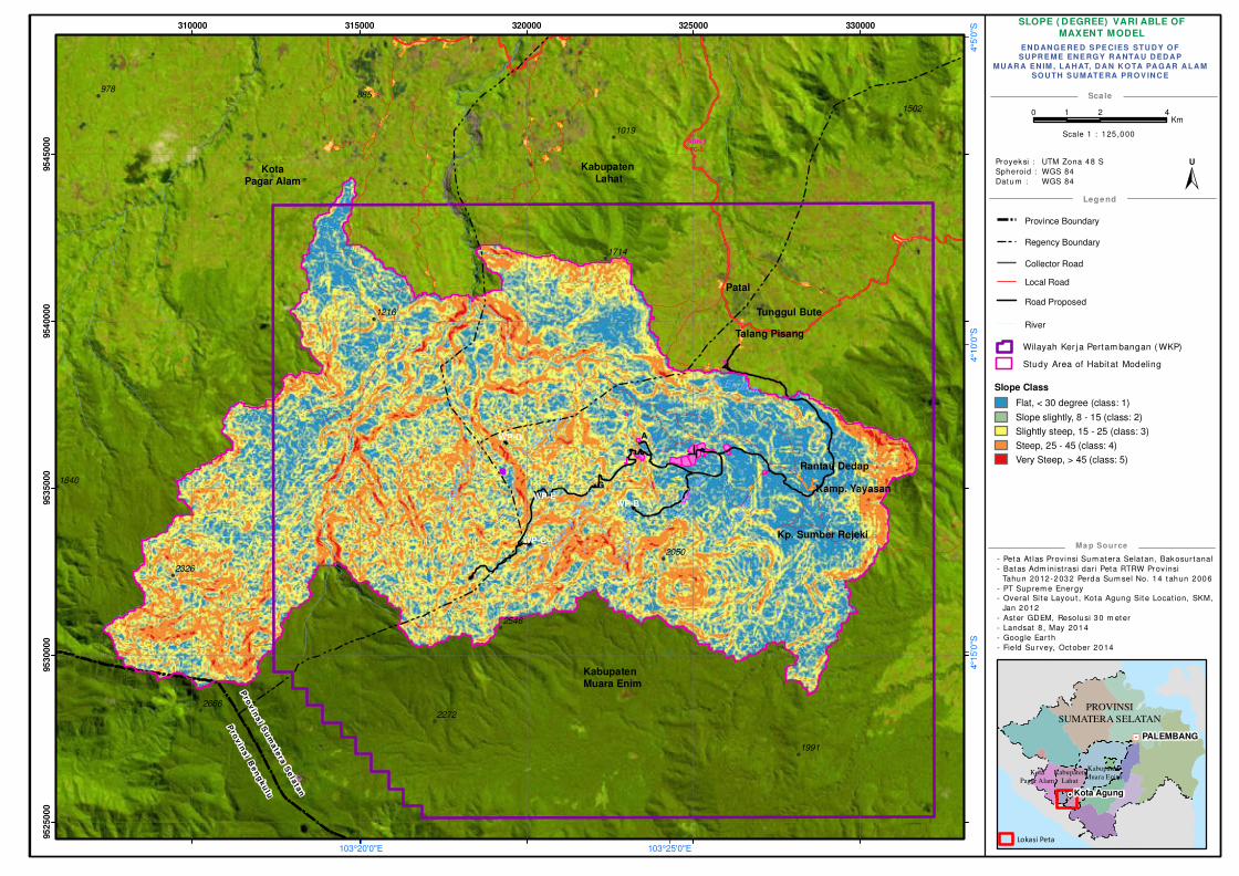
SLOPE ( DEGREE) VARI ABLE OF
MAXENT MODEL
- Peta At las Provinsi Sum atera Selatan, Bakosur tanal
- Batas Adm inist rasi dar i Peta RTRW Provinsi
Tahun 2012-2032 Perda Sum sel No. 14 tahun 2006
- PT Suprem e Energy
- Overal Si te Layou t , Kota Agung Site Locat ion, SKM,
Jan 2012
- Aster GDEM, Resolusi 30 m eter
- Landsat 8 , May 2014
- Google Ear th
- Field Survey, October 2014
Sca le
Lege nd
Ma p Source
! !!
!
! !
!
!
!
!!
!!!!
!
!
!
!
!
!
! !
!
!
!
!
!
!
!
!
!
!
!
!
!
!
!
!
!!!
!!
!
!
!
!
!
!
!
!
!
!
!
!
!
!H
PROVINSI
SUMATERA SELATAN
PALEMBANG
Kota Agung
Kota
Pagar Alam
Kabupaten
Lahat
Kabupaten
Muara Enim
Lokasi Peta
Province Boundary
Regency Boundary
Collector Road
Local Road
Road Proposed
EN D AN GE RE D S PE CIES STU D Y OFSU PR E ME EN E RGY R A NTA U D ED A P
MU AR A EN IM , LA H AT, D A N K OTA PA GAR A LA MSOU TH S U MATE RA PR OV IN C E
Proyeksi :
Spheroid :
Datum :
UTM Zona 48 S
WGS 84
WGS 84
"/
!(
!(
!(
!(
!(
!(
!(
!(
!(
!(
!(
!(
!(
A
WP-B
G
WP-C
WP-D
Rantau Dedap
Talang Pisang
Tunggul Bute
Patal
Kp. Sumber Rejeki
I
Kamp. YayasanWP-E
Pro
vin
si S
um
ate
ra S
ela
tan
Pro
vin
si B
en
gk
ulu
Kabupaten Lahat
Kabupaten Muara Enim
KotaPagar Alam
AQN-5
TC-2
S.
Asa
han
S.
Endik
atK
anan
S. Endikat
S. D
edap
an
S. C
awan
g Te
ngah
S. Air
Angat
978885
2272
1991
1216
2326
1714
2050
1502
1840
2666
2546
1019
S. C
aw
ang K
iri
103°25'0"E103°20'0"E
4°5
'0"S
4°1
0'0
"S4°1
5'0
"S
310000 315000 320000 325000 330000
95
25
00
095
30
00
095
35
00
095
40
00
095
45
00
0
0 2 41Km
±U
Scale 1 : 125 ,000
Slope Class
Flat, < 30 degree (class: 1)
Slope slightly, 8 - 15 (class: 2)
Slightly steep, 15 - 25 (class: 3)
Steep, 25 - 45 (class: 4)
Very Steep, > 45 (class: 5)
River
Wilayah Ker j a Pertam bangan ( WKP)
Study Area of Habitat Modeling
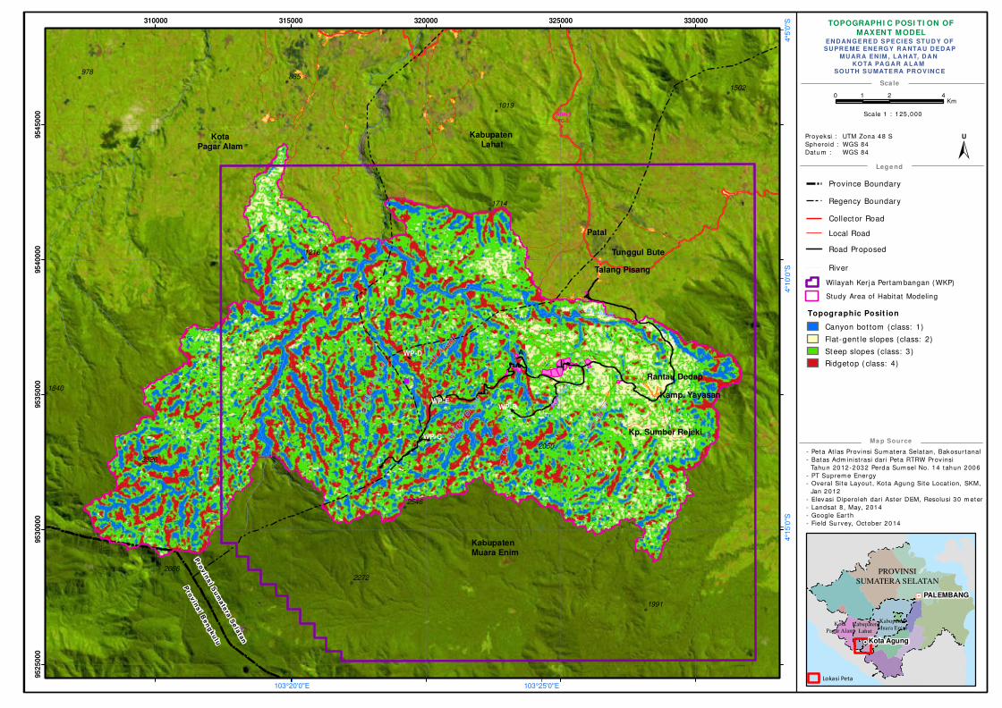
TOPOGRAPHI C POSI TI ON OF
MAXENT MODEL
- Peta At las Provinsi Sum atera Selatan, Bakosur tanal
- Batas Adm inist rasi dar i Peta RTRW Provinsi
Tahun 2012-2032 Perda Sum sel No. 14 tahun 2006
- PT Suprem e Energy
- Overal Si te Layou t , Kota Agung Site Locat ion, SKM,
Jan 2012
- Elevasi Diperoleh dar i Aster DEM, Resolusi 30 m eter
- Landsat 8 , May, 2014
- Google Ear th
- Field Survey, October 2014
Sca le
Lege nd
Ma p Source
! !!
!
! !
!
!
!
!!
!!!!
!
!
!
!
!
!
! !
!
!
!
!
!
!
!
!
!
!
!
!
!
!
!
!
!!!
!!
!
!
!
!
!
!
!
!
!
!
!
!
!
!H
PROVINSI
SUMATERA SELATAN
PALEMBANG
Kota Agung
Kota
Pagar Alam
Kabupaten
Lahat
Kabupaten
Muara Enim
Lokasi Peta
Province Boundary
Regency Boundary
Collector Road
Local Road
Road Proposed
EN D AN GE RE D S PE CIES STU D Y OFSU PR E ME EN E RGY R A NTA U D ED A P
MU AR A EN IM , LA H AT, D A N KOTA PA GA R A LA M
SOU TH S U MATE RA PR OV IN C E
Proyeksi :
Spheroid :
Datum :
UTM Zona 48 S
WGS 84
WGS 84
"/
!(
!(
!(
!(
!(
!(
!(
!(
!(
!(
!(
!(
!(
A
WP-B
G
WP-C
WP-D
Kabupaten Lahat
Kabupaten Muara Enim
Rantau Dedap
Talang Pisang
Tunggul Bute
Patal
Kp. Sumber Rejeki
I
Kamp. YayasanWP-E
KotaPagar Alam
Pro
vin
si S
um
ate
ra S
ela
tan
Pro
vin
si B
en
gk
ulu
AQN-5
TC-2
S.
Asa
han
S.
Endik
atK
anan
S. Endikat
S. D
edap
an
S. C
awan
g Te
ngah
S. Air
Angat
978885
2272
1991
1216
2326
1714
2050
1502
1840
2666
2546
1019
S. C
aw
ang K
iri
103°25'0"E103°20'0"E
4°5
'0"S
4°1
0'0
"S4°1
5'0
"S
310000 315000 320000 325000 330000
95
25
00
095
30
00
095
35
00
095
40
00
095
45
00
0
0 2 41Km
±U
Scale 1 : 125 ,000
Topographic Posit ion
Canyon bot tom (class: 1)
Flat-gent le slopes (class: 2)
Steep slopes (class: 3)
Ridgetop ( class: 4)
River
Wilayah Ker j a Pertam bangan ( WKP)
Study Area of Habitat Modeling
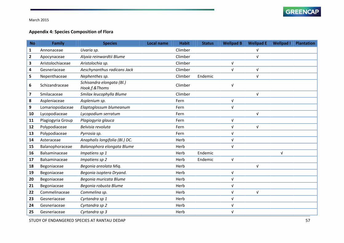
March 2015
STUDY OF ENDANGERED SPECIES AT RANTAU DEDAP 57
Appendix 4: Species Composition of Flora
No Family Species Local name Habit Status Wellpad B Wellpad E Wellpad I Plantation
1 Annonaceae Uvaria sp. Climber
√
2 Apocynaceae Alyxia reinwardtii Blume Climber
√
3 Aristolochiaceae Aristolochia sp. Climber √
4 Gesneriaceae Aeschynanthus radicans Jack Climber √ √
5 Nepenthaceae Nephenthes sp. Climber Endemic
√
6 Schizandraceae Schisandra elongata (Bl.)
Hook.f.&Thoms Climber √
7 Smilacaceae Smilax leucophylla Blume Climber
√
8 Aspleniaceae Asplenium sp. Fern √
9 Lomariopsidaceae Elaptoglossum blumeanum Fern √
10 Lycopodiaceae Lycopodium serratum Fern
√
11 Plagiogyria Group Plagiogyria glauca Fern √
12 Polypodiaceae Belvisia revoluta Fern √ √
13 Polypodiaceae Pyrrosia sp. Fern √
14 Asteraceae Anaphalis longifolia (Bl.) DC. Herb √
15 Balanophoraceae Balanophora elongata Blume Herb √
16 Balsaminaceae Impatiens sp 1 Herb Endemic
√
17 Balsaminaceae Impatiens sp 2 Herb Endemic √
18 Begoniaceae Begonia areolata Miq. Herb
√
19 Begoniaceae Begonia isoptera Dryand. Herb √
20 Begoniaceae Begonia muricata Blume Herb √
21 Begoniaceae Begonia robusta Blume Herb √
22 Commelinaceae Commelina sp. Herb √ √
23 Gesneriaceae Cyrtandra sp 1 Herb √
24 Gesneriaceae Cyrtandra sp 2 Herb √
25 Gesneriaceae Cyrtandra sp 3 Herb √

March 2015
STUDY OF ENDANGERED SPECIES AT RANTAU DEDAP 58
No Family Species Local name Habit Status Wellpad B Wellpad E Wellpad I Plantation
26 Hypoxidaceae Curculigo orchimoides Gaertn. Herb
√
27 Melastomataceae Sonerila tenuifolia Blume Herb
√
28 Polygonaceae Polygonum chinense L. Herb
√
29 Rubiaceae Argostemma borragineum DC. Herb
√
30 Rubiaceae Argostemma montanun Bl. ex
DC. Herb
√
31 Rubiaceae Argostemma uniflorum Bl. ex
DC. Herb √
√
32 Rubiaceae Ophiorrhiza junghuniana Miq. Herb √
√
33 Rubiaceae Ophiorrhiza longiflora Blume Herb
√
34 Urticaceae Elatostema sinuatum (Bl.)
Hassk. Herb
√
35 Urticaceae Elatostema strigosum (Bl.)
Hassk. Herb √
36 Vittariaceae Antrophyum caliifolium Herb √
37 Vittariaceae Antrophyum latifolium Herb √
38 Zingiberaceae Etlingera sp. Herb √
39 Orchidaceae Macodes javanica (Bl.) Hook.f. Orchid √
40 Orchidaceae Macodes petola Lindl. Orchid
√
41 Orchidaceae Cryptostylis arachnites Hassk. Orchid
√
42 Orchidaceae Dendrobium mutabile (Bl.) Lindl. Orchid
√
43 Orchidaceae Gendup Orchid √ √ √
44 Musaceae Musa acuminata Colla Pisang hutan Other √
45 Arecaceae Caryota mitis Lour. Basao Palm √
46 Arecaceae Pinanga sp. Palm √ √
47 Arecaceae Calamus spp. Rattan √
48 Araliaceae Trevesia sundaica Miq. Shrub √
49 Chloranthaceae Sarcandra glabra Shrub
√
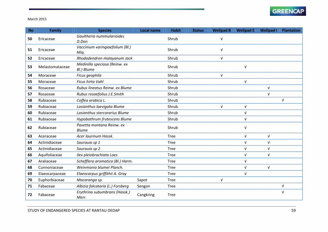
March 2015
STUDY OF ENDANGERED SPECIES AT RANTAU DEDAP 59
No Family Species Local name Habit Status Wellpad B Wellpad E Wellpad I Plantation
50 Ericaceae Gaultheria nummularioides
D.Don Shrub √
51 Ericaceae Vaccinium varingiaefolium (Bl.)
Miq. Shrub √
52 Ericaceae Rhododendron malayanum Jack Shrub √
53 Melastomataceae Medinilla speciosa (Reinw. ex
Bl.) Blume Shrub
√
54 Moraceae Ficus geophila Shrub √
55 Moraceae Ficus hirta Vahl Shrub
√
56 Rosaceae Rubus lineatus Reinw. ex Blume Shrub
√
57 Rosaceae Rubus rosaefolius J.E.Smith Shrub
√
58 Rubiaceae Coffea arabica L. Shrub
√
59 Rubiaceae Lasianthus laevigata Blume Shrub √ √
60 Rubiaceae Lasianthus stercorarius Blume Shrub
√
61 Rubiaceae Hypobathrum frutescens Blume Shrub
√
62 Rubiaceae Pavetta montana Reinw. ex
Blume Shrub
√
63 Aceraceae Acer laurinum Hassk. Tree
√ √
64 Actinidiaceae Saurauia sp 1 Tree
√ √
65 Actinidiaceae Saurauia sp 2 Tree
√ √
66 Aquifoliaceae Ilex pleiobrachiata Loes Tree
√ √
67 Araliaceae Schefflera aromatica (Bl.) Harm. Tree
√
68 Cunnoniaceae Weinmania blumei Planch. Tree
√ √
69 Elaeocarpaceae Elaeocarpus griffithii A. Gray Tree
√
70 Euphorbiaceae Macaranga sp. Sapot Tree √
71 Fabaceae Albizia falcataria (L.) Forsberg Sengon Tree
√
72 Fabaceae Erythrina subumbrans (Hassk.)
Merr. Cangkring Tree
√

March 2015
STUDY OF ENDANGERED SPECIES AT RANTAU DEDAP 60
No Family Species Local name Habit Status Wellpad B Wellpad E Wellpad I Plantation
73 Fabaceae Leucaena leucocephala (Lmk)
De Wit Lamtoro Tree
√
74 Fagaceae Lithocarpus spp. Pasang Tree √ √ √
75 Fagaceae Quercus spp. Pasang Tree
√ √
76 Flacourtiaceae Casearia sp. Tree
√
77 Icacinaceae Platea excelsa Blume Tree
√ √
78 Lauraceae Actinodaphne procera Nees Tree
√ √
79 Lauraceae Cryptocarya ferrea Blume Medang Tree
√ √
80 Lauraceae Cryptocarya sp 1 Tree
√ √
81 Lauraceae Cryptocarya sp 2 Tree
√ √
82 Lauraceae Cryptocarya sp 3 Tree
√
83 Lauraceae Lindera bibracteata (Bl.) Boerl. Tree
√
84 Lauraceae Litsea cubeba (Lour.) Pers. Tree
√
85 Lauraceae Litsea elliptica Tree
√
86 Lauraceae Litsea montana Tree
√ √
87 Lauraceae Litsea sp 1 Tree
√
88 Magnoliaceae Magnolia candolii Noteboom Cempaka Tree √
89 Meliaceae Aglaia sp 1 Beke elang Tree
√ √
90 Meliaceae Aglaia sp 2 Tree
√
91 Meliaceae Aglaia sp 3 Tree
√
92 Meliaceae Aglaia sp 4 Tree √
93 Myristicaceae Myristica sp. Getah merah Tree √
94 Myrsinaceae Rapanea hasseltii Metz Tree
√
95 Myrtaceae Syzygium lineatum Merr.&
Perry Tree
√ √
96 Myrtaceae Syzygium sp 1 Kayu kelat Tree
√ √
97 Myrtaceae Syzygium sp 2 Tree
√
98 Nyssaceae Nyssa javanica (Bl.) Wang Tree
√
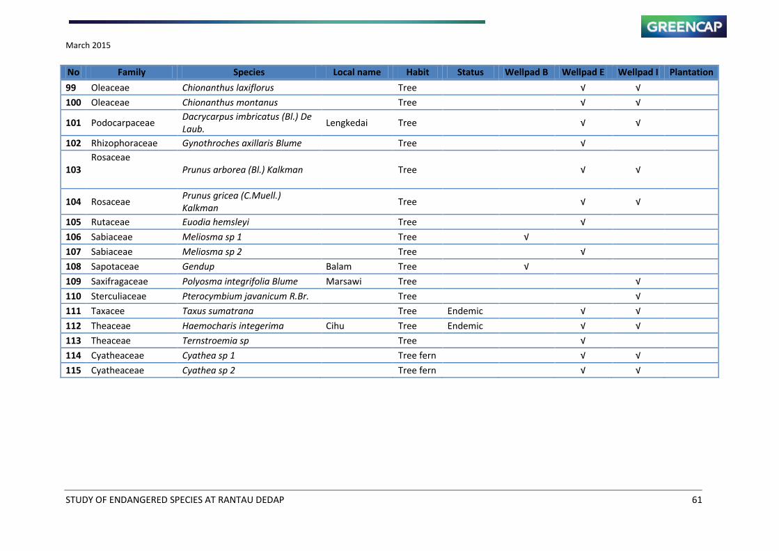
March 2015
STUDY OF ENDANGERED SPECIES AT RANTAU DEDAP 61
No Family Species Local name Habit Status Wellpad B Wellpad E Wellpad I Plantation
99 Oleaceae Chionanthus laxiflorus Tree
√ √
100 Oleaceae Chionanthus montanus Tree
√ √
101 Podocarpaceae Dacrycarpus imbricatus (Bl.) De
Laub. Lengkedai Tree
√ √
102 Rhizophoraceae Gynothroches axillaris Blume Tree
√
103
Rosaceae
Prunus arborea (Bl.) Kalkman Tree
√ √
104 Rosaceae Prunus gricea (C.Muell.)
Kalkman Tree
√ √
105 Rutaceae Euodia hemsleyi Tree
√
106 Sabiaceae Meliosma sp 1 Tree √
107 Sabiaceae Meliosma sp 2 Tree
√
108 Sapotaceae Gendup Balam Tree √
109 Saxifragaceae Polyosma integrifolia Blume Marsawi Tree
√
110 Sterculiaceae Pterocymbium javanicum R.Br. Tree
√
111 Taxacee Taxus sumatrana Tree Endemic
√ √
112 Theaceae Haemocharis integerima Cihu Tree Endemic
√ √
113 Theaceae Ternstroemia sp Tree
√
114 Cyatheaceae Cyathea sp 1 Tree fern
√ √
115 Cyatheaceae Cyathea sp 2 Tree fern
√ √
Greencap
Intiland Tower | 18th
Floor
Jl. Jend. Sudirman Kav. 32
Jakarta 10220
Indonesia
P: +62 21 5790 1344
F: +62 21 5790 1348
www.greencap.com.au
MONITORING REPORT OF ENDANGERED
SPECIES STUDY OF RANTAU DEDAP
SUPREME ENERGY RANTAU DEDAP (SERD)
Muara Enim Regency and Pagar Alam City, South Sumatra
Province
January 2015
JI100114
February 2015
STUDY OF ENDANGERED STUDY OF RANTAU DEDAP i
MONITORING REPORT OF ENDANGERED STUDY OF RANTAU
DEDAP
PT SUPREME ENERGY RANTAU DEDAP (SERD)
Muara Enim Regency and Pagar Alam City, South Sumatra Province
TABLE OF CONTENTS
Table of Contents .......................................................................................................... i
List of Table .................................................................................................................. ii
List of Figure ................................................................................................................ iii
List of Maps ................................................................................................................. iv
MONITORING REPORT OF ENDANGERED SPECIES STUDY OF RANTAU DEDAP
(17 – 21 DECEMBER 2014 and 28 January – 1 February 2015) ......................................... 1
February 2015
STUDY OF ENDANGERED STUDY OF RANTAU DEDAP ii
LIST OF TABLE
Table 1 Distribution Species Findings ........................................................................................ 2
Table 2 Camera Trap Monitoring Result (17 – 21 December 2014 and
28 January – 1 February 2015) ...................................................................................... 3
February 2015
STUDY OF ENDANGERED STUDY OF RANTAU DEDAP iii
LIST OF FIGURE
Figure 1 Dhole (Cuon alpinus) photographs 1
February 2015
STUDY OF ENDANGERED STUDY OF RANTAU DEDAP iv
LIST OF MAPS
Map 1 Camera Trap Location 10
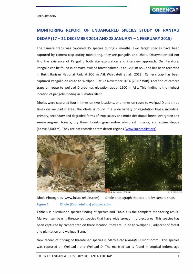
February 2015
STUDY OF ENDANGERED STUDY OF RANTAU DEDAP 1
MONITORING REPORT OF ENDANGERED SPECIES STUDY OF RANTAU
DEDAP (17 – 21 DECEMBER 2014 AND 28 JANUARY – 1 FEBRUARY 2015)
The camera traps was captured 15 species during 2 months. Two target species have been
captured by camera trap during monitoring, they are pangolin and Dhole. Observation did not
find the existence of Pangolin, both site exploration and interview approach. On literature,
Pangolin can be found in primary lowland forest habitat up to 1200 m ASL. and has been recorded
in Bukit Barisan National Park at 900 m ASL (Wirdateti et al., 2013). Camera trap has been
captured Pangolin on route to Wellpad D at 22 November 2014 (20:07 WIB). Location of camera
traps on route to wellpad D area has elevation about 1900 m ASL. This finding is the highest
location of pangolin finding in Sumatra Island.
Dholes were captured fourth times on two locations, one times on route to wellpad D and three
times on wellpad B area. The dhole is found in a wide variety of vegetation types, including:
primary, secondary and degraded forms of tropical dry and moist deciduous forest; evergreen and
semi-evergreen forests; dry thorn forests; grassland–scrub–forest mosaics; and alpine steppe
(above 3,000 m). They are not recorded from desert regions (www.iucnredlist.org).
Dhole Photograps (www.brucekekule.com) Dhole photograph that capture by camera traps
Figure 1 Dhole (Cuon alpinus) photographs
Table 1 is distribution species finding of species and Table 2 is the complete monitoring result.
Malayan sun bear is threatened species that have wide spread in project area. This species has
been captured by camera trap on three location, they are Route to Wellpad D, adjacent of forest
and plantation and wellpad B area.
New record of finding of threatened species is Marble cat (Pardofelis marmorata). This species
was captured on Wellpad I and Wellpad D. The marbled cat is found in tropical Indomalaya
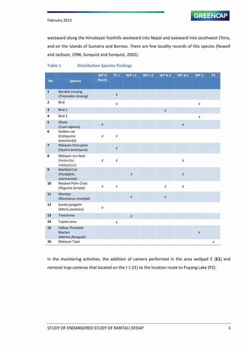
February 2015
STUDY OF ENDANGERED STUDY OF RANTAU DEDAP ii
westward along the Himalayan foothills westward into Nepal and eastward into southwest China,
and on the islands of Sumatra and Borneo. There are few locality records of this species (Nowell
and Jackson, 1996, Sunquist and Sunquist, 2002).
Table 1 Distribution Species Findings
No Species
WP D
Route
PL 1 WP I-1 WP I-2 WP B-2 WP B-1 WP C P2
1 Banded Linsang
(Prionodon linsang) √
2 Bird
√
√
3 Bird 1
√
4 Bird 3
√
5 Dhole
(Cuon alpinus) √
√
6 Golden cat
(Catopuma
temminckii)
√ √
7 Malayan Porcupine
(Hystrix brachyura) √
8 Malayan sun bear
(Helarctos
malayanus)
√ √
√
9 Marbled Cat
(Pardofelis
marmorata)
√
√
10 Masked Palm Civet
(Paguma larvata) √ √
√ √
11 Muntjac
(Muntiacus muntjak) √
√
12 Sunda pangolin
(Manis javanica) √
13 Treeshrew
√
14 Tupaia tana
√
15 Yellow Throated
Marten
(Martes flavigula)
√
16 Malayan Tapir √
In the monitoring activities, the addition of camera performed in the area wellpad E (E1) and
removal trap cameras that located on the I-1 (I1) to the location route to Puyang Lake (P2).
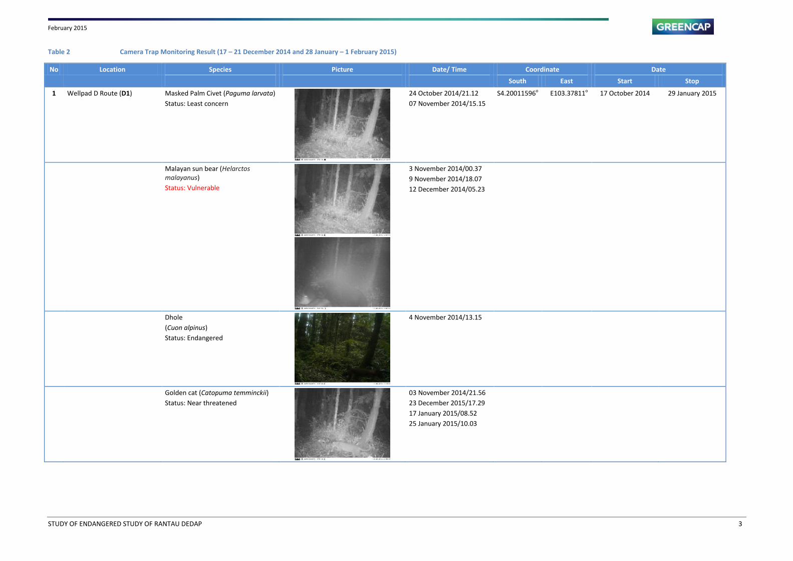
February 2015
STUDY OF ENDANGERED STUDY OF RANTAU DEDAP 3
Table 2 Camera Trap Monitoring Result (17 – 21 December 2014 and 28 January – 1 February 2015)
No Location Species Picture Date/ Time Coordinate Date
South East Start Stop
1 Wellpad D Route (D1) Masked Palm Civet (Paguma larvata)
Status: Least concern
24 October 2014/21.12
07 November 2014/15.15
S4.20011596o E103.37811
o 17 October 2014 29 January 2015
Malayan sun bear (Helarctos
malayanus)
Status: Vulnerable
3 November 2014/00.37
9 November 2014/18.07
12 December 2014/05.23
Dhole
(Cuon alpinus)
Status: Endangered
4 November 2014/13.15
Golden cat (Catopuma temminckii)
Status: Near threatened
03 November 2014/21.56
23 December 2015/17.29
17 January 2015/08.52
25 January 2015/10.03
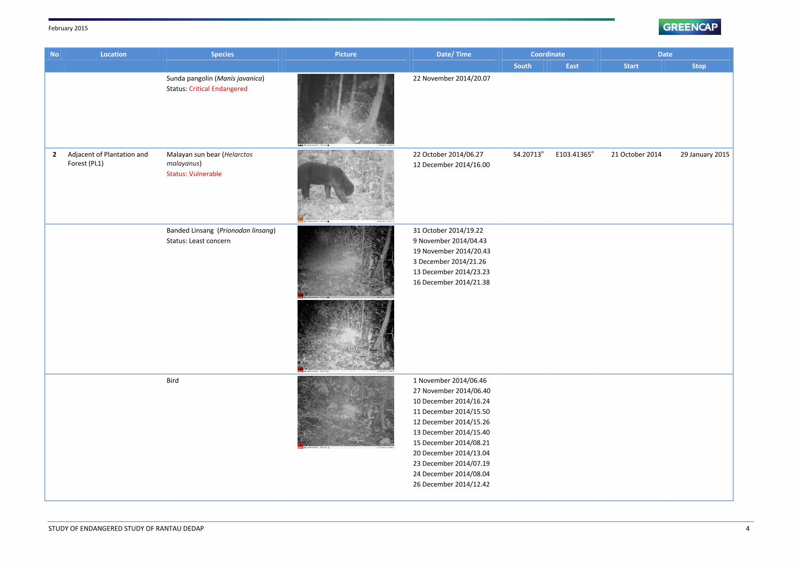
February 2015
STUDY OF ENDANGERED STUDY OF RANTAU DEDAP 4
No Location Species Picture Date/ Time Coordinate Date
South East Start Stop
Sunda pangolin (Manis javanica)
Status: Critical Endangered
22 November 2014/20.07
2 Adjacent of Plantation and
Forest (PL1)
Malayan sun bear (Helarctos
malayanus)
Status: Vulnerable
22 October 2014/06.27
12 December 2014/16.00
S4.20713o E103.41365
o 21 October 2014 29 January 2015
Banded Linsang (Prionodon linsang)
Status: Least concern
31 October 2014/19.22
9 November 2014/04.43
19 November 2014/20.43
3 December 2014/21.26
13 December 2014/23.23
16 December 2014/21.38
Bird
1 November 2014/06.46
27 November 2014/06.40
10 December 2014/16.24
11 December 2014/15.50
12 December 2014/15.26
13 December 2014/15.40
15 December 2014/08.21
20 December 2014/13.04
23 December 2014/07.19
24 December 2014/08.04
26 December 2014/12.42

February 2015
STUDY OF ENDANGERED STUDY OF RANTAU DEDAP 5
No Location Species Picture Date/ Time Coordinate Date
South East Start Stop
Masked Palm Civet (Paguma larvata)
Status: Least concern
3 November 2014/03.18
13 November 2014/01.42
17 December 2014/00.41
8 January 2015/12.39
Golden cat (Catopuma temminckii)
Status: Near threatened
6 November 2014/22.38
Malayan Porcupine (Hystrix
brachyura)
Status: Least concern
11 November 2014/22.25
Tupai tanah
21 November 2014/12.14
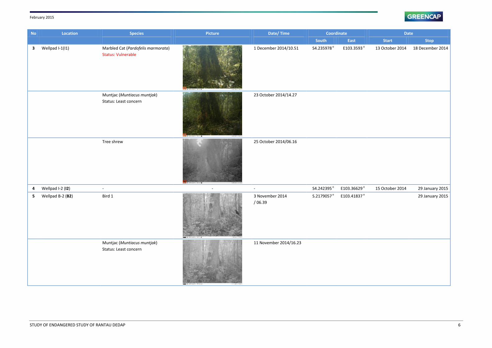
February 2015
STUDY OF ENDANGERED STUDY OF RANTAU DEDAP 6
No Location Species Picture Date/ Time Coordinate Date
South East Start Stop
3 Wellpad I-1(I1) Marbled Cat (Pardofelis marmorata)
Status: Vulnerable
1 December 2014/10.51 S4.235978 o
E103.3593 o
13 October 2014 18 December 2014
Muntjac (Muntiacus muntjak)
Status: Least concern
23 October 2014/14.27
Tree shrew
25 October 2014/06.16
4 Wellpad I-2 (I2) - - - S4.242395 o
E103.36629 o
15 October 2014 29 January 2015
5 Wellpad B-2 (B2) Bird 1
3 November 2014
/ 06.39
S.2179057 o
E103.41837 o
29 January 2015
Muntjac (Muntiacus muntjak)
Status: Least concern
11 November 2014/16.23
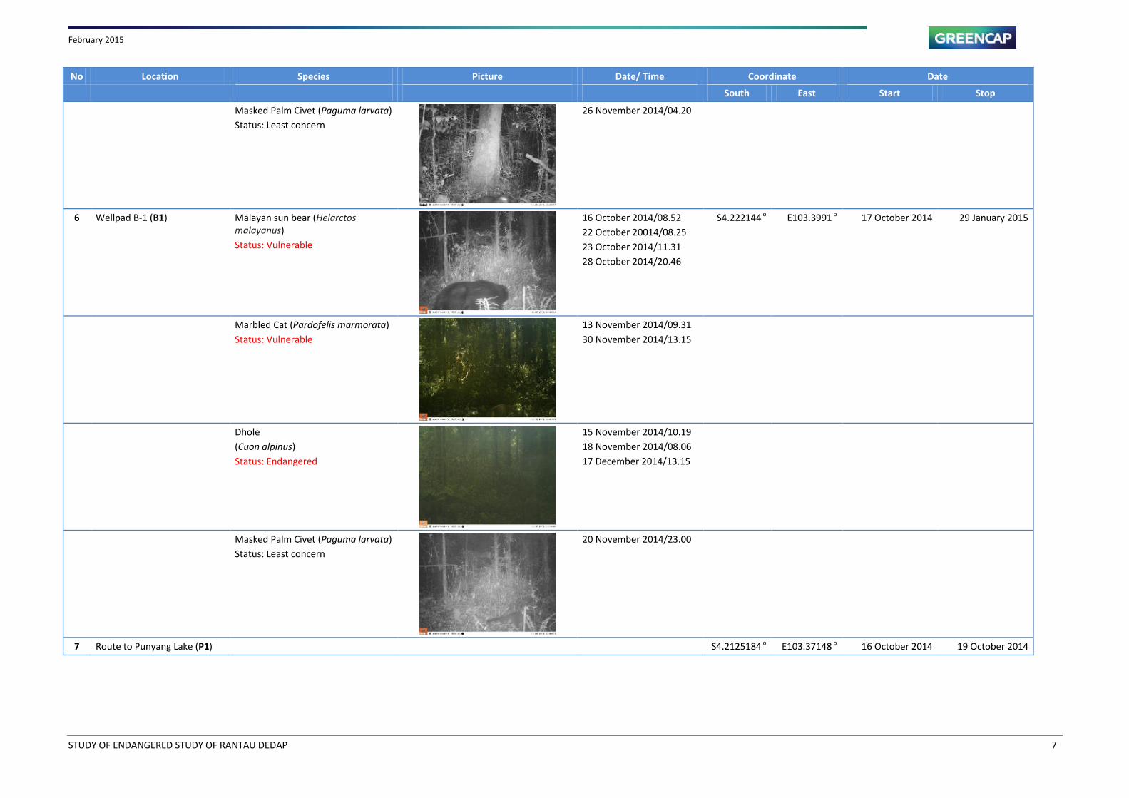
February 2015
STUDY OF ENDANGERED STUDY OF RANTAU DEDAP 7
No Location Species Picture Date/ Time Coordinate Date
South East Start Stop
Masked Palm Civet (Paguma larvata)
Status: Least concern
26 November 2014/04.20
6 Wellpad B-1 (B1) Malayan sun bear (Helarctos
malayanus)
Status: Vulnerable
16 October 2014/08.52
22 October 20014/08.25
23 October 2014/11.31
28 October 2014/20.46
S4.222144 o
E103.3991 o
17 October 2014 29 January 2015
Marbled Cat (Pardofelis marmorata)
Status: Vulnerable
13 November 2014/09.31
30 November 2014/13.15
Dhole
(Cuon alpinus)
Status: Endangered
15 November 2014/10.19
18 November 2014/08.06
17 December 2014/13.15
Masked Palm Civet (Paguma larvata)
Status: Least concern
20 November 2014/23.00
7 Route to Punyang Lake (P1) S4.2125184 o
E103.37148 o
16 October 2014 19 October 2014
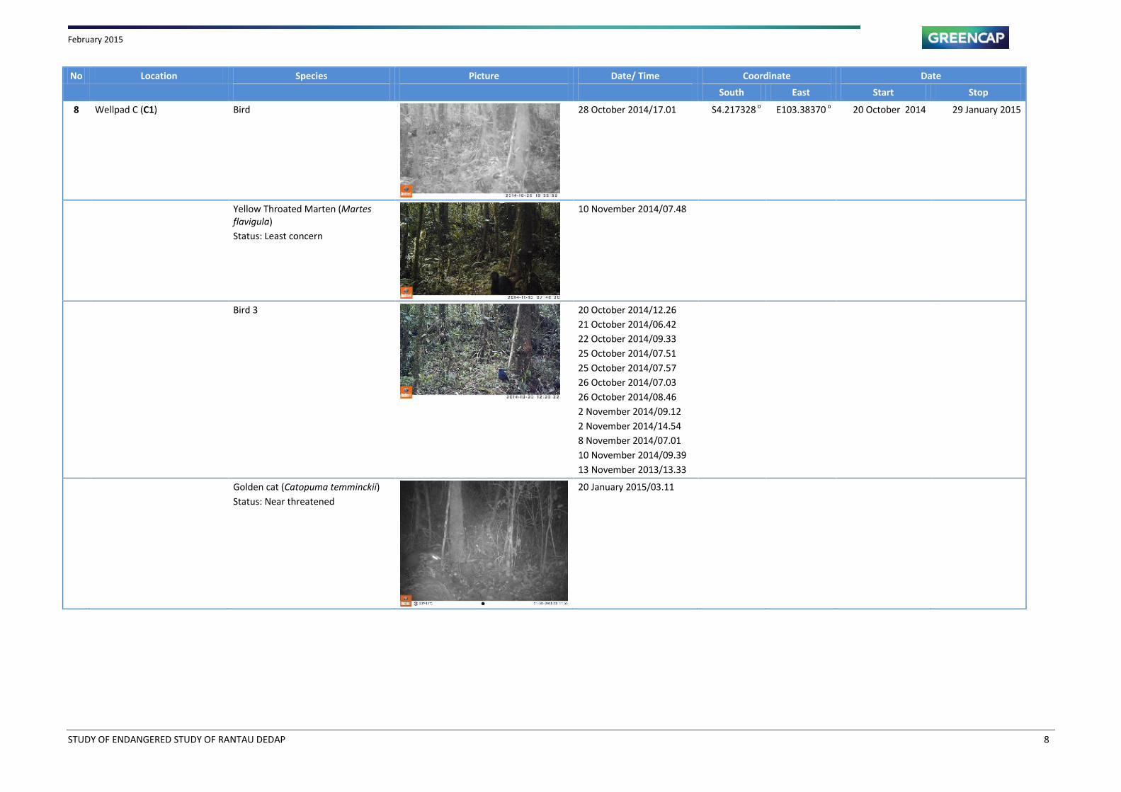
February 2015
STUDY OF ENDANGERED STUDY OF RANTAU DEDAP 8
No Location Species Picture Date/ Time Coordinate Date
South East Start Stop
8 Wellpad C (C1) Bird
28 October 2014/17.01 S4.217328 o
E103.38370 o
20 October 2014 29 January 2015
Yellow Throated Marten (Martes
flavigula)
Status: Least concern
10 November 2014/07.48
Bird 3
20 October 2014/12.26
21 October 2014/06.42
22 October 2014/09.33
25 October 2014/07.51
25 October 2014/07.57
26 October 2014/07.03
26 October 2014/08.46
2 November 2014/09.12
2 November 2014/14.54
8 November 2014/07.01
10 November 2014/09.39
13 November 2013/13.33
Golden cat (Catopuma temminckii)
Status: Near threatened
20 January 2015/03.11
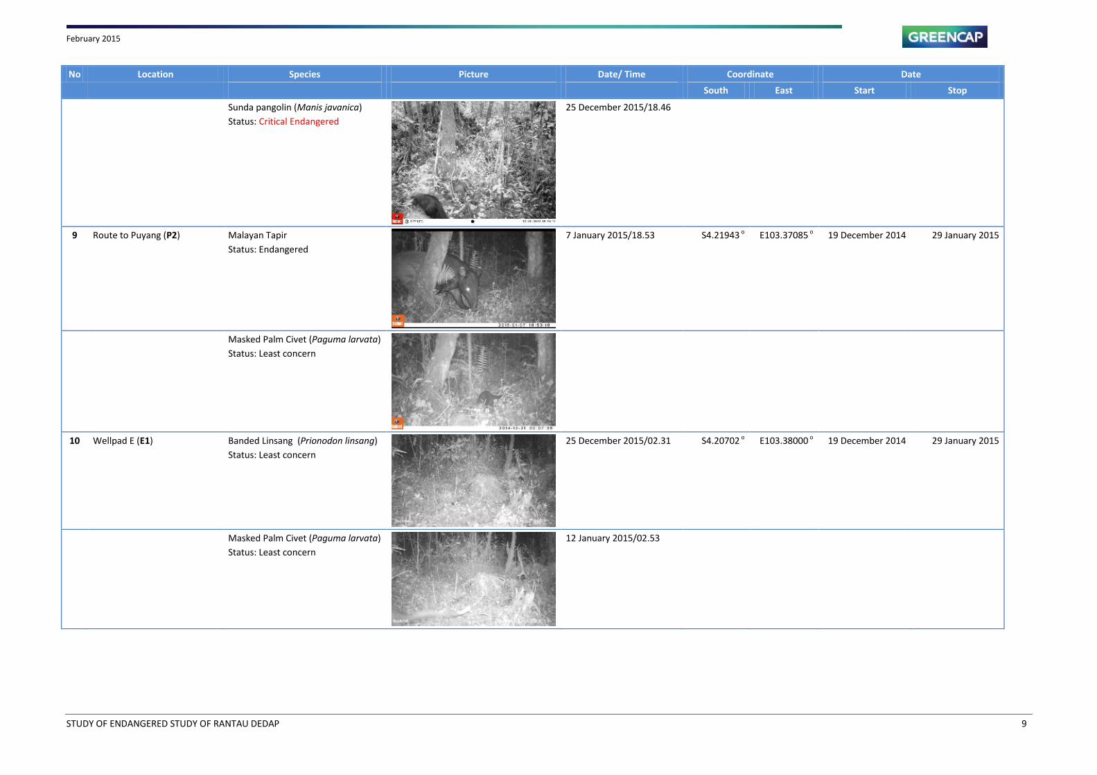
February 2015
STUDY OF ENDANGERED STUDY OF RANTAU DEDAP 9
No Location Species Picture Date/ Time Coordinate Date
South East Start Stop
Sunda pangolin (Manis javanica)
Status: Critical Endangered
25 December 2015/18.46
9 Route to Puyang (P2) Malayan Tapir
Status: Endangered
7 January 2015/18.53 S4.21943 o
E103.37085 o
19 December 2014 29 January 2015
Masked Palm Civet (Paguma larvata)
Status: Least concern
10 Wellpad E (E1) Banded Linsang (Prionodon linsang)
Status: Least concern
25 December 2015/02.31 S4.20702 o
E103.38000 o
19 December 2014 29 January 2015
Masked Palm Civet (Paguma larvata)
Status: Least concern
12 January 2015/02.53
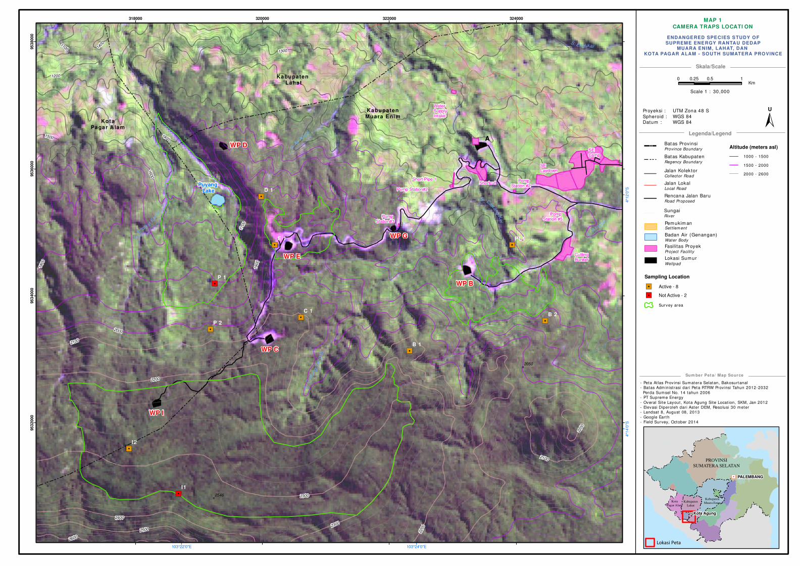
MAP 1
CAMERA TRAPS LOCATI ON
- Peta Atlas Provinsi Sumatera Selatan, Bakosurtanal
- Batas Adm inist rasi dari Peta RTRW Provinsi Tahun 2012-2032
Perda Sumsel No. 14 tahun 2006
- PT Supreme Energy
- Overal Site Layout , Kota Agung Site Locat ion, SKM, Jan 2012
- Elevasi Diperoleh dar i Aster DEM, Resolusi 30 meter
- Landsat 8, August 08, 2013
- Google Ear th
- Field Survey, October 2014
Skala/Scale
Legenda/Legend
Sum ber Pet a/ Map Source
! !!
!
! !
!
!
!
!!
! !!!
!!
!
!
!!
!
!
!
! !
!
!
!
!
!
!
!
!
!!
!
!
!
!
!
!
!
!!
!
!
!!!
!!
!
!
!
!
!
!
!
!
!
!
!
!
!
!
!
!
!
!H
PROVINSI
SUMATERA SELATAN
PALEMBANG
Kota Agung
Kota
Pagar Alam
Kabupaten
Lahat
Kabupaten
Muara Enim
Lokasi Peta
Batas ProvinsiProvince Boundary
Batas KabupatenRegency Boundary
Jalan Kolek torCollector Road
Jalan LokalLocal Road
Rencana Jalan Baru Road Proposed
Pemukim an
Badan Air (Genangan)Water Body
Set tlem ent
Fasilitas ProyekProject Facilit y
Lokasi SumurWellpad
ENDANGERED SPECIES STUDY OFSUPREME ENERGY RANTAU DEDAP
MUARA ENIM, LAHAT, DAN KOTA PAGAR ALAM - SOUTH SUMATERA PROVINCE
Proyeksi :
Spheroid :
Datum :
UTM Zona 48 S
WGS 84
WGS 84
"/
!(
!(
"/
"/
"/
"/
"/
"/"/
"/"/
"/
A
Pump Station#2
SE Camp
SE Laydown
Cutting Bunker
WP B
WP G
WaterSupplyIntake
WP C
WP D
Kabupaten Muara Enim
WP I
Short Pipe 1 Pomp Station #2
Pump Station#3
Pomp Station #5
Shortcut
WP E
Kabupaten Lahat
KotaPagar A lam
I1
I2
P 2
E 1 PL1
B 2C 1
P 1
B 1
D 1
S. A
saha
n
S.
E
ndika t Kan
an
S. Caw
angK
iri
S.C
aw
ang
Te
ngah
S. End ikat
S. Air
Angat
1700
1800
1600
1900
15001400
2000
2100
2200
2300
1300
2400
2500
1200
1100
2600
1400
2200
2200
2100
2300
2050
2546
103°24'0"E103°22'0"E
4°1
2'0
"S4°1
4'0
"S
318000 320000 322000 324000
95
32
00
095
34
00
095
36
00
095
38
00
0
0 0.5 10.25Km
±U
Altitude (meters asl)
1000 - 1500
1500 - 2000
2000 - 2600
Scale 1 : 30,000
Sampling Location
"/ Active - 8
"/ Not Active - 2
Survey area
SungaiRiver
Puyang Lake