inshore and offshore special area of conservation: pobie...
TRANSCRIPT

Inshore and Offshore Special Area of Conservation: Pobie Bank Reef
SAC Selection Assessment Document
©DTI, 2003
Version 5.0 (31st October 2012)
*Cover photo illustrates Annex I bedrock reef with encrusting coralline algae and bryozoans and abundant soft corals (Alcyonium digitatum) at Pobie Bank Reef.

Pobie Bank Reef SAC Selection Assessment: Version 5.0 Page 2 of 22 31/10/2012 jncc.defra.gov.uk
Introduction This document provides detailed information about the Pobie Bank Reef site and evaluates its interest features according to the Habitats Directive selection criteria and guiding principles. The advice contained within this document is produced to fulfil requirements of of Scottish Natural Heritage under The Conservation (Natural Habitats, & c.) Regulations 1994 (as amended) and JNCC under Part 2 of the Offshore Marine Conservation (Natural Habitats, & c.) Regulations 2007 (as amended), relating to the conservation of natural habitat types and habitats of species through identification of Special Areas of Conservation (SACs) in UK inshore and offshore waters. Under these Regulations, JNCC and SNH have an obligation to provide certain advice to Scottish Government to enable the Secretary of State to fulfil his obligations under the Regulations, and to Competent Authorities to enable them to fulfil their obligations under the Regulations. This document includes information required under Regulation 7 of the Offshore Marine Conservation (Natural Habitats, & c.) Regulations 2007 (as amended), to enable the Secretary of State to transmit to the European Commission the list of sites eligible for designation as Special Areas of Conservation (SACs). JNCC and SNH have been asked by Scottish Government to provide this information. Sites eligible for designation as offshore marine SACs are selected on the basis of the criteria set out in Annex III (Stage 1) to the Habitats Directive and relevant scientific information. Sites are considered only if they host a Habitats Directive Annex I habitat or Annex II species. Moreover, sites for Annex II species that are highly mobile must contain a clearly identifiable area that presents physical and biological factors essential to these species’ life and reproduction to be eligible. Socio-economic factors are not taken into account in the identification of sites proposed to the European Commission. 1 In addition to information on the Annex I habitats and/or Annex II species hosted within the site, this document contains i) a chart of the site, ii) its name, location and extent, and iii) the data resulting from application of the criteria specified in Annex III (Stage 1) to the Habitats Directive. This is in line with legal requirements outlined under Regulation 7. JNCC has adhered to the format established by the Commission for providing site information. This format is set out in the ‘Natura 2000 Standard data form’ (CEC, 2011) (prepared by the European Topic Centre for Biodiversity and Nature Conservation on behalf of the European Commission to collect standardised information on SACs throughout Europe).
1 Following European Court of Justice ‘First Corporate Shipping’ judgement C-371/98 (7 November 2000)
Pobie Bank Reef SAC Selection Assessment: Version 5.0 Page 3 of 22 31/10/2012 jncc.defra.gov.uk
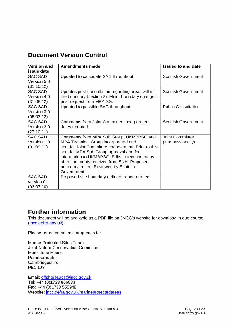
Document Version Control Version and issue date
Amendments made Issued to and date
SAC SAD Version 5.0 (31.10.12)
Updated to candidate SAC throughout Scottish Government
SAC SAD Version 4.0 (31.08.12)
Updates post-consultation regarding areas within the boundary (section 8). Minor boundary changes, post request from MPA SG.
Scottish Government
SAC SAD Version 3.0 (05.03.12)
Updated to possible SAC throughout Public Consultation
SAC SAD Version 2.0 (27.10.11)
Comments from Joint Committee incorporated, dates updated.
Scottish Government
SAC SAD Version 1.0 (01.09.11)
Comments from MPA Sub Group, UKMBPSG and MPA Technical Group incorporated and sent for Joint Committee endorsement. Prior to this sent for MPA Sub Group approval and for information to UKMBPSG. Edits to text and maps after comments received from SNH. Proposed boundary edited; Reviewed by Scottish Government.
Joint Committee (intersessionally)
SAC SAD version 0.1 (02.07.10)
Proposed site boundary defined; report drafted
Further information This document will be available as a PDF file on JNCC’s website for download in due course (jncc.defra.gov.uk). Please return comments or queries to: Marine Protected Sites Team Joint Nature Conservation Committee Monkstone House Peterborough Cambridgeshire PE1 1JY Email: [email protected] Tel: +44 (0)1733 866833 Fax: +44 (0)1733 555948 Website: jncc.defra.gov.uk/marineprotectedareas

Pobie Bank Reef SAC Selection Assessment: Version 5.0 Page 4 of 22 31/10/2012 jncc.defra.gov.uk
Pobie Bank Reef SAC: Selection Assessment Document
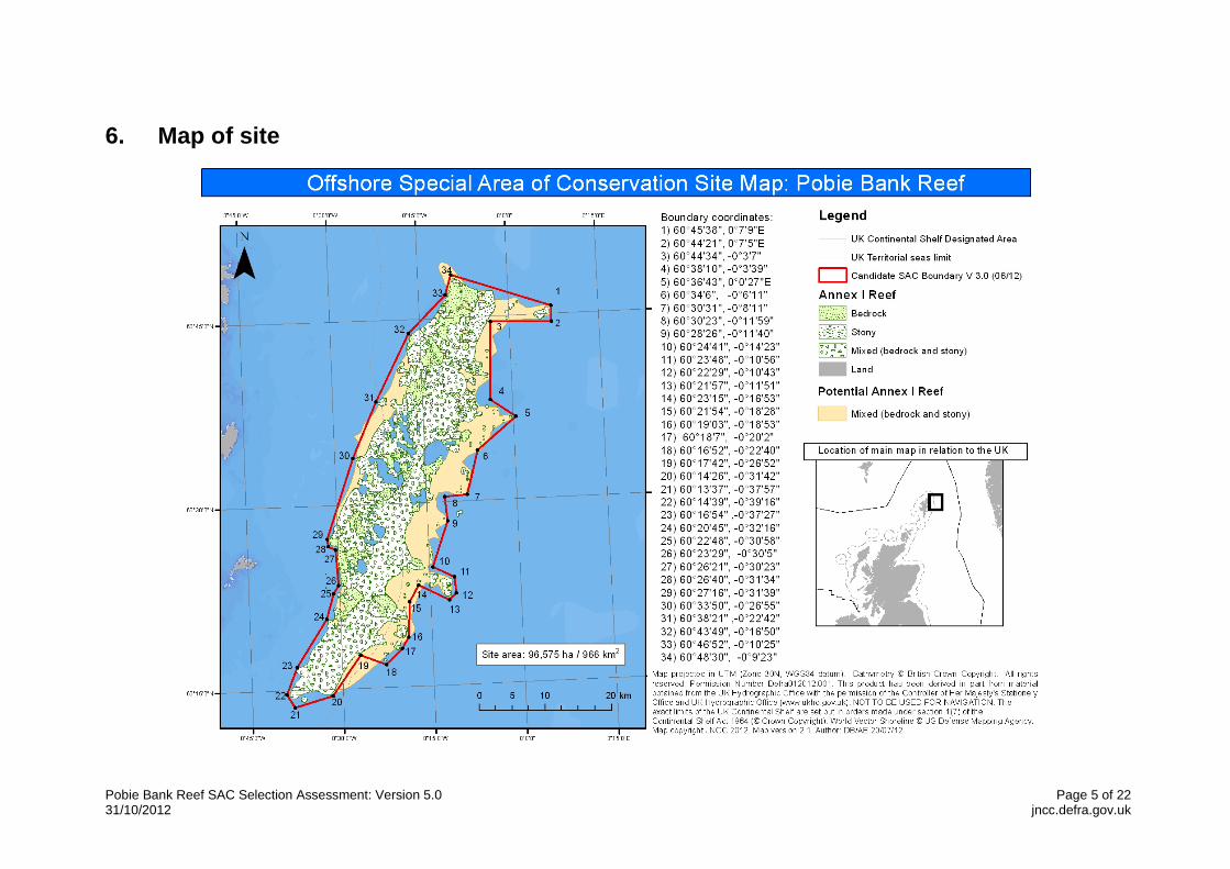
1. Site name Pobie Bank Reef
2. Site centre location 60º31'47″N, 0º17'35″W (Datum: WGS 1984)
3. Site surface area 96,575 ha / 966 km2 (Datum: WGS 1984 UTM Zone 30 North, calculated in ArcGIS)
4. Biogeographic region Atlantic
5. Interest features under the EU Habitats Directive 1170 Reefs 1135 Harbour porpoise (Phocoena phocoena) (Non-qualifying) 1364 Grey seal (Halichoerus grypus) (Non-qualifying) 1365 Harbour (common) seal (Phoca vitulina) (Non-qualifying)
Pobie Bank Reef SAC Selection Assessment: Version 5.0 Page 5 of 22 31/10/2012 jncc.defra.gov.uk
6. Map of site

Pobie Bank Reef SAC Selection Assessment: Version 5.0 Page 6 of 22 31/10/2012 jncc.defra.gov.uk
7. Site summary Pobie Bank Reef is located in the North Sea, approximately 20 km east of Unst, Fetlar and Whalsey in Shetland and is separated from Shetland by the Unst Basin. The cSAC is approximately 70 km long (crest running NNE to SSW) and up to 21 km wide. The depth within the cSAC ranges from 70 m to over 100 m; the average seabed depth within the site boundary is approximately 90 m. The reef is located on a bank of metamorphic and sedimentary rocks covered by a patchy veneer of sediment, ranging from sandy gravels to slightly gravelly sands. The bank overlays a flat plain of sedimentary rock, known as the East of Shetland Platform. The reef is composed of a combination of stony and bedrock reef which meet the definition of the Annex I habitat type 1170: Reef, under the EC Habitats Directive. In the central section of the reef, very large, rugged bedrocks outcrop from areas of sand and this represents the most topographically complex area. In most areas these outcrops are surrounded by large boulders and cobbles in a sandy matrix. Towards the north and south of the reef, bedrock outcrops are smoother and integrated with extensive areas of stony reef. The reef provides a habitat to an extensive community of encrusting and robust sponges and bryozoans, which are found throughout the site. In the shallowest areas the bedrock and boulders also support encrusting coralline algae. Axinellid cup sponges (Axinella infundibuliformis) are common on the bedrock and stony reef at depth ranges of 70m to over 100m. The bryozoan Omalosecosa ramulosa is also common on these reefs, but this species is rare in inshore sites in this regional sea. In the deepest areas (>100 m), low-lying silty bedrock is commonplace, supporting small erect sponges, cup corals (Caryophyllia smithii) and the brittlestar Ophiura albida. The site is located within the Northern North Sea Regional Sea (JNCC, 2004; Defra, 2004). There are four SACs within this regional sea for which reef is a qualifying feature. These are shown in the table below, along with their characteristic features. Pobie Bank Reef is very different in character to these sites due to its depth; there are no other marine Natura sites within this regional sea containing deep circalittoral bedrock and stony reef. SAC Noteable characteristics of reef interest feature Berwickshire and North Northumberland Coast SAC
Bedrock reef of medium to high topographic complexity. The reef is located in intertidal to circalittoral waters with strong coastal influence and is exposed to moderate energy levels and full salinity waters.
Isle of May SAC Bedrock reef of medium to high topographic complexity and stony reef in intertidal to circalittoral waters, with intermediate coastal influence. Exposed to moderate to high energy levels and full salinity waters.
Dornoch Firth and Morrich More SAC
Bedrock reef of low topographic complexity, stony reef and Mytilus edulis reef. The reef occurs in shallow (intertidal and infralittoral) waters with strong coastal influence. Exposed to variable energy levels and medium to low salinity waters.

Pobie Bank Reef SAC Selection Assessment: Version 5.0 Page 7 of 22 31/10/2012 jncc.defra.gov.uk
Mousa SAC Bedrock reef of medium to high topographic complexity, with stony and biogenic (Modiolus modiolus) reef. Located in intertidal to circalittoral waters and exposed to intermediate coastal influence, high to moderate energy levels and full salinity waters.
Within the adjacent Scottish Continental Shelf regional sea nine other areas have been proposed or are being considered for their Annex I reef. These are shown below with its characteristic features. SAC Notable characteristics of the Reef interest feature Sanday SAC (Scottish Continental Shelf Regional Sea)
Bedrock reef of low topographic complexity in intertidal and subtidal waters with moderate energy levels. The reefs are in full salinity waters, and are subject to strong coastal influence. Dense forests of kelp Laminaria spp (to 20m depth) provide a habitat for species-rich, red algal turf communities. Sponges (e.g.Clathrina coriacea) and ascidians (e.g. Aplidium punctum) occur on the vertical rock faces. The tide-swept north coast supports a rich fauna of dense bryozoan/hydroid turf and dense brittlestar and horse mussel (Modiolus modiolus) beds in mixed sediment below the kelp zone.
Papa Stour SAC (Scottish Continental Shelf Regional Sea)
Very exposed bedrock and stony reefs of high topographic complexity (intertidal, infralittoral and circalittoral) reaching depths of more than 30m. The reefs are in full salinity waters, and are subject to moderate coastal influence. Extensive kelp forests extend to depths of up to 28m. Circalittoral communities are dominated by the soft coral Alcyonium digitatum, the featherstar Antedon bifida, encrusting coralline algae and the serpulid worm Pomatoceros, with turfs of the jewel anemone Corynactis viridis, ascidians and bryozoans. Scour-tolerant organisms such as the hydroid Abietinaria abietina and the brittlestar Ophiocomina nigra are also present.
North Rona SAC (Scottish Continental Shelf Regional Sea)
Bedrock reef habitats of low and medium topographic complexity extending from the intertidal to the circalittoral. Support rich marine communities characteristic of very exposed, conditions (sponges, anemones, soft corals and ascidians). Kelp forests extend as deep as 35m. The reef is subject to full salinity and moderate coastal influences. The influence of the North Atlantic Drift is apparent in the presence of many southern species, but colder sub-arctic water accounts for the northern elements of the fauna and flora.
Sullom Voe SAC (Scottish Continental Shelf Regional Sea)
Bedrock, stony and biogenic reef (Modiolus modiolus) in intertidal to circalittoral waters. Present in full salinity waters, exposed to a strong coastal influence and low to high energy levels. Intertidal rocky reefs range from steep, moderately-exposed bedrock at the seaward limit of the site to gradually sloping, extremely-sheltered bedrock in the inner reaches of the voes. Sublittoral bedrock is dominated by forests of the kelp Laminaria hyperborea. Bedrock and boulders below the kelp forest are heavily grazed but coralline algae, the keel worm Pomatoceros triqueter and the soft coral Alcyonium digitatum, may be present. There is a well-established horse mussel, Modiolus modiolus reef throughout the channel.
St Kilda SAC (Scottish Continental Shelf
Extremely wave-exposed bedrock reefs composed of hard, igneous rock, forming steep and vertical faces. These topographically complex reefs extend to depths of 50 m (encompassing the intertidal, infralittoral and circalittoral) and are subject to minimal coastal
Pobie Bank Reef SAC Selection Assessment: Version 5.0 Page 8 of 22 31/10/2012 jncc.defra.gov.uk
Regional Sea) influence, full salinity waters and moderate to full energy levels. Dense kelp forests may occur as deep as 35 m due to water clarity. The reefs are dominated by diverse communities of anemones, sponges and soft corals, with different species of sponge, hydroid and bryozoan occurring in surge gullies and caves.
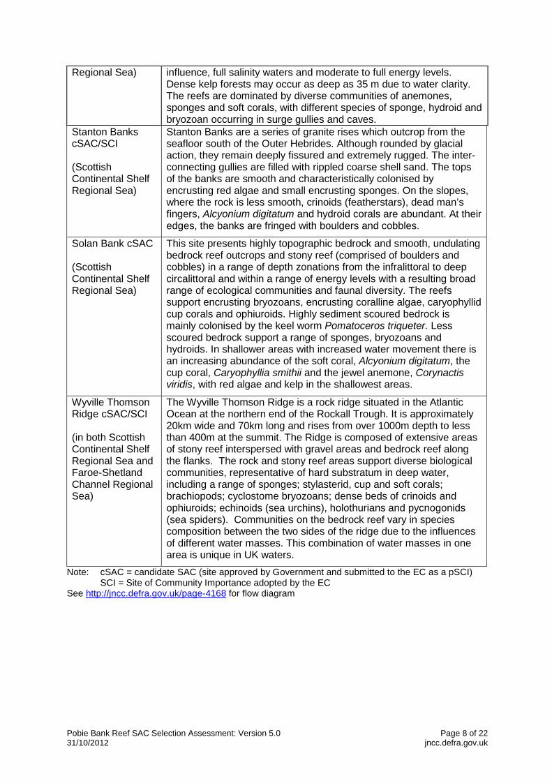
Stanton Banks cSAC/SCI (Scottish Continental Shelf Regional Sea)
Stanton Banks are a series of granite rises which outcrop from the seafloor south of the Outer Hebrides. Although rounded by glacial action, they remain deeply fissured and extremely rugged. The inter-connecting gullies are filled with rippled coarse shell sand. The tops of the banks are smooth and characteristically colonised by encrusting red algae and small encrusting sponges. On the slopes, where the rock is less smooth, crinoids (featherstars), dead man’s fingers, Alcyonium digitatum and hydroid corals are abundant. At their edges, the banks are fringed with boulders and cobbles.
Solan Bank cSAC (Scottish Continental Shelf Regional Sea)
This site presents highly topographic bedrock and smooth, undulating bedrock reef outcrops and stony reef (comprised of boulders and cobbles) in a range of depth zonations from the infralittoral to deep circalittoral and within a range of energy levels with a resulting broad range of ecological communities and faunal diversity. The reefs support encrusting bryozoans, encrusting coralline algae, caryophyllid cup corals and ophiuroids. Highly sediment scoured bedrock is mainly colonised by the keel worm Pomatoceros triqueter. Less scoured bedrock support a range of sponges, bryozoans and hydroids. In shallower areas with increased water movement there is an increasing abundance of the soft coral, Alcyonium digitatum, the cup coral, Caryophyllia smithii and the jewel anemone, Corynactis viridis, with red algae and kelp in the shallowest areas.
Wyville Thomson Ridge cSAC/SCI (in both Scottish Continental Shelf Regional Sea and Faroe-Shetland Channel Regional Sea)
The Wyville Thomson Ridge is a rock ridge situated in the Atlantic Ocean at the northern end of the Rockall Trough. It is approximately 20km wide and 70km long and rises from over 1000m depth to less than 400m at the summit. The Ridge is composed of extensive areas of stony reef interspersed with gravel areas and bedrock reef along the flanks. The rock and stony reef areas support diverse biological communities, representative of hard substratum in deep water, including a range of sponges; stylasterid, cup and soft corals; brachiopods; cyclostome bryozoans; dense beds of crinoids and ophiuroids; echinoids (sea urchins), holothurians and pycnogonids (sea spiders). Communities on the bedrock reef vary in species composition between the two sides of the ridge due to the influences of different water masses. This combination of water masses in one area is unique in UK waters.
Note: cSAC = candidate SAC (site approved by Government and submitted to the EC as a pSCI) SCI = Site of Community Importance adopted by the EC
See http://jncc.defra.gov.uk/page-4168 for flow diagram

Pobie Bank Reef SAC Selection Assessment: Version 5.0 Page 9 of 22 31/10/2012 jncc.defra.gov.uk
8. Site boundary The boundary for Pobie Bank Reef cSAC has been defined using JNCC’s marine SAC boundary definition guidelines (JNCC, 2012). The boundary is a relatively simple polygon enclosing the minimum area necessary to ensure protection of the Annex I habitat. The Annex I reef feature has been interpreted from acoustic and groundtruthing data collected during surveys in 2003 and 2006. A confidence map was produced for the distribution of Annex I reef feature (Appendix 2). Regions of potential reef delineated using data types with the lowest confidence were excluded from the site boundary where there was no supplementary data of higher confidence covering the area. This low confidence data includes BGS potential reef areas (Gafeira et al., 2010) where data did not have either any groundtruthing or areas of interpolated data, and were therefore just based on depth contours or charts. This data is considered by JNCC too unreliable to designate boundaries from in this area. In this way we are ensuring that we use only the best available evidence and minimise the amount of non-qualifying Annex I reef enclosed within the cSAC boundary. As any bottom trawling that occurs in the area may pose a threat to the reef, the cSAC boundary includes a margin to allow for mobile gear on the seabed being at some distance from the location of a vessel at the sea surface. The maximum depth of water around the feature is approximately 100m; assuming a ratio of 3:1 fishing warp length to depth on the continental shelf (as per UK guidance described in (JNCC, 2012), the boundary is defined to include a margin of 300m from the bedrock and stony reef feature. Note that the boundary described is for the candidate SAC. Any future management measures which may be needed to meet the requirements of the Offshore Marine Conservation (Natural Habitats, & c.) Regulations 2007 (as amended) will be determined by Competent Authorities in consultation with JNCC, and may have different boundaries to the SAC site boundary.
9. Assessment of interest feature against selection criteria
9.1. Reefs
Annex III selection criteria (Stage 1A)
a) Representativity Pobie Bank Reef is located in the Northern North Sea and represents hard bedrock and stony reef of medium to high topographic complexity, in deep, circalittoral waters. It is present in full salinity waters, subject to intermediate coastal influence and moderate to high energy levels. The shallowest areas (~70m-85m) of bedrock and stony reef at Pobie Bank Reef support communities of encrusting coralline algae, with encrusting bryozoans, sponges, the soft coral Alcyonium digitatum and the tube worm Pomatoceros triqueter. In the deeper (>85m) areas, silty bedrock reef supports communities of Axinellid cup sponges and the cup coral Caryophyllia smithii. The brittlestar, Ophiura albida commonly occurs on silty sediment surrounding the outcropping bedrock. The two main biotope complexes identified on these deeper areas of bedrock reef (CR.HCR.DpSp and a deeper variant of CR.MCR.EcCr) are

Pobie Bank Reef SAC Selection Assessment: Version 5.0 Page 10 of 22 31/10/2012 jncc.defra.gov.uk
not commonly found within this regional sea, largely due to the extremely limited distribution of the associated deep circalittoral rocky habitat. For some of the biotopes described, variations on the representative species used to classify them have been accommodated (due to the appearance of rare, more northerly species in some areas). These variations include the sponge, Phakellia rugosa, the fish, Icelus bicornis and the serpulid worm Ditrupa areatina, which forms dense aggregations in some areas of Pobie Bank Reef. The bedrock and stony reef is an excellent example of deep, circalittoral reef, and is the only known extensive example within this regional sea. The grade for this feature is A: excellent representativity
b) Area of habitat The reef feature is approximately 82,032 ha (820 km2) in area (flat mapped extent). This has been estimated from a study of multibeam data, backscatter data and seabed imagery. The data was interpreted and the reef extent was mapped accordingly.
An estimate of the entire Annex I reef resource (bedrock, stony and biogenic reef) in UK waters is 7,180,000 hectares. This total extent figure gives the following thresholds for the grades of this criterion (CEC, 2011): A – extents between 1,077,000 and 7,180,000 ha (15-100% of total resource) B – extents between 143,600 and 1,077,000 ha (2-15% of total resource) C – extents less than 143,600 ha (0-2% of total resource) This site’s feature therefore falls within the “0-2%” bracket for Area of Habitat and is graded C.
c) Conservation of structure and functions
Degree of conservation of structure Available evidence indicates bottom trawling is common in the region of Pobie Bank Reef and static gear is apparent in seabed imagery taken during a DTI (now DECC) survey of Pobie Bank in 2003. However, VMS data of fishing activity suggests that although the reef itself is avoided to protect gear from damage or loss, fishing vessels trawl very close to the reef feature and in some small localised areas, target pockets of sandy sediment that intersperse the reef feature. Oil and gas exploration occurs to the west and north-east of the Shetland Islands, but this is located at some distance from the site. Further to this, two pipelines are located to the north-western edge of the site. These were installed in 2001 and are therefore unlikely to have any further impact on the site. The grading for this sub-criterion is therefore II: structure well conserved.
Degree of conservation of functions The prospects of this feature to maintain its structure in the future, taking into account unfavourable influences and reasonable conservation effort, are good. A mechanism is available through the European Commission’s Common Fisheries Policy regulations to modify fishing activity in the area if this is deemed to be necessary. In addition, regulations

Pobie Bank Reef SAC Selection Assessment: Version 5.0 Page 11 of 22 31/10/2012 jncc.defra.gov.uk
are in place to regulate oil and gas activity in and around SACs in the UK Continental Shelf Designated Area. The laying of submarine cables and pipelines also requires regulatory consent which considers SACs. The reef is distant from terrestrial sources of pollution. The grading is II: good prospects.
Restoration possibilities Restoration of the biological communities in the Pobie Bank Reef would be possible, accepting that restoration methods in the offshore area focus on the removal of impacts which should allow recovery where the habitat has not been removed. It is likely that a similar community to that present now would develop if activities causing damage were removed. The grading is II: restoration possible with an average effort.
Overall grade Due to the first sub-criterion of this criterion being graded II: structure well conserved, and second sub-criterion also being graded II: good prospects, the overall grading is B: good conservation, regardless of the third sub-criterion.
d) Global assessment The suggested grades for Stage 1A criteria (a) to (c) are A, C and B respectively. Taking all the above factors into consideration, the Global Assessment grade is B (‘good conservation value’).
Summary of scores for Stage 1a criteria Habitat type Representativity Area of
habitat Structure and function
Global assessment
Pobie Bank Reef
A C B B
9.2. Harbour porpoise (Phocoena phocoena) - Annex III selection criteria (Stage 1B)
a) Proportion of UK population Harbour porpoise (Phocoena phocena) are found throughout the majority of UK continental shelf waters, with regular sightings around Shetland particularly in the summer months (Evans et al, 2003; Reid et al, 2003; SCANS 2008). At this time, however, it is not possible to estimate what proportion of the population utilises the area, or how important the area is with respect to the physical and biological factors essential to their life and reproduction. Due to the highly mobile nature of the species and the size of the cSAC, a grade D (non-significant population) is considered most appropriate. Therefore harbour porpoise is not a qualifying species for this site. As such, no other indication is required for the additional evaluation criteria concerning this species within the site. This assessment may change if new evidence becomes available.
Pobie Bank Reef SAC Selection Assessment: Version 5.0 Page 12 of 22 31/10/2012 jncc.defra.gov.uk
9.3. Bottlenose dolphin (Tursiops truncatus) - Annex III selection criteria (Stage 1B)
a) Proportion of UK population This species is found in many parts of UK waters, on the Continental Shelf and further offshore (Evans et al, 2003; Reid et al, 2003; SCANS II, 2008). There are no records of bottlenose dolphin occurrences within the cSAC boundary (Reid et al, 2003) therefore the species is not considered a feature of the site. However, they have been recorded in the vicinity of the site (Evans et al, 2003) and are highly mobile, so this assessment may change if new data become available.
9.4. Grey seal (Halichoerus grypus) and Harbour (common) seal (Phoca vitulina) - Annex III selection criteria (Stage 1B)
a) Proportion of UK Population Both harbour and grey seals have haul out sites on the east coast of Shetland and, from satellite telemetry work, they appear to forage in or very near the area (Sharples et al, 2005; Matthiopoulos et al, 2004; Matthiopoulos, 2007; Duck, 2009; Duck & Thompson, 2009). At this time, however, it is not possible to estimate what proportion of either population utilises the area, or how important the area is with respect to the physical and biological factors essential to their life and reproduction. Therefore, both species are considered to be grade D (non-significant population). Therefore grey seal and harbour seal are not qualifying species for this site. This grading may be revised at a later date depending on the outcome of data analyses to be commissioned by JNCC that will enable a more detailed assessment of the importance of areas for seals at sea.
10. Sites to which this site is related None
11. Supporting scientific documentation Scientific information to support this SAC designation predominantly comes from the following sources:
• The Department of Trade and Industry (DTI) (now Department of Energy and Climate Change: DECC) Strategic Environmental Assessment (SEA) survey in 2003 for Area 5 (SEA5) and its associated survey reports (Black, 2003; McDougall, 2003);
• the Department of Trade and Industry (DTI) (now Department of Energy and Climate Change: DECC) SEA Special Area for Conservation survey in 2006 (SEA SAC 2006) and its associated report (Howell et al, 2007);
• a geological data interpretation of the Area of Search (AoS) by the British Geological Survey (BGS) (Green et al, 2008); and
• a biological analysis and interpretation of the SEA data (Foster-Smith et al, 2009). Data was gathered under the SEA5 survey using two vessels in 2003; the R/V Jean Charcot acquired multibeam and sidescan sonar data, while groundtruthing data (seabed imagery and biological/sediment samples) were acquired using the R/V Kommandor Jack. Similar methods were undertaken for the SEA SAC 2006 survey aboard the M/V Franklin to gather

Pobie Bank Reef SAC Selection Assessment: Version 5.0 Page 13 of 22 31/10/2012 jncc.defra.gov.uk
acoustic data and seabed imagery data (Figure 1 and 2). Although full coverage multibeam and sidescan data was not present for all locations where potential Annex I reef was indicated (Green et al, 2008), the available data has provided a good indication of the nature of Annex I reef habitat present within Pobie Bank Reef cSAC. Following these surveys, a desk study undertaken by BGS reviewed historic geophysical data to provide a more accurate determination of the spatial extent of Annex I reef habitat within the area of Pobie Bank Reef. The following data sources were utilised in this interpretation:
• BGS paper archive records of offshore samples (over 400 BGS sea-bed sample records were reviewed) ;
• Paper archive records of sidescan and transit sonar collected by the BGS; • Paper sub-bottom (pinger and boomer) records collected by the BGS; • Sea-bed sediment map sheets for Shetland and Halibut Bank, published at
1:250,000 (Chesher, 1984; Owens et al, 1984 and Stevenson and Ruckley, 1998); • Unpublished maps of the Quaternary sea-bed morphology for the area covered by
the Shetland 1:250,000 map sheet; • Multibeam bathymetry, sea-bed photographs, video footage and particle size
analysis from the SEA5 and SEA SAC 2006 surveys. The resulting data layer, which showed the potential extent of outcropping rock (Figure 1), was used as the basis for the development of a broadscale habitat map for Pobie Bank Reef. A further detailed analysis and interpretation of SEA acoustic and biological data was undertaken by Foster-Smith et al (2009). A supervised classification and interpolation of the acoustic data was undertaken in IDRISITM with the seabed imagery being used to ‘groundtruth’ the resultant map (see Appendix I). Using this approach, a broadscale habitat map (Figure 2), mapped to biotope level within the Marine Habitat Classification for Britain and Ireland (Connor et al, 2004) and an Annex I habitat map (see site map) were developed. Due to the variation in data used to create the Annex I habitat map, a confidence map was created to help understand the differences in data used across the site. This also allowed a more informed decision when identifying the potential boundary for the site.
Confidence was split into 3 levels and categorised as follows:
1. Highest confidence. Annex I reef derived from acoustic data coverage and/or groundtruthing data.
2. Medium confidence. Annex I reef derived from data interpolation techniques using mapping software.
3. Low confidence. Potential Annex I reef derived by extension of the reef feature into potential reef areas identified by BGS.

Pobie Bank Reef SAC Selection Assessment: Version 5.0 Page 14 of 22 31/10/2012 jncc.defra.gov.uk
Figure 1. Data map showing multibeam data coverage from the SEA SAC 2006 survey and SEA5 2003 survey (blues and greens represent greater depths (>100m), oranges and yellows represent shallower depths (<100m)), plus the BGS potential spatial extent of Annex I reef habitat and locations of BGS sample points used to determine this extent.

Pobie Bank Reef SAC Selection Assessment: Version 5.0 Page 15 of 22 31/10/2012 jncc.defra.gov.uk
Figure 2. Broadscale habitat map with images of Phakellia ventilabrum and Axinellid sponges on deep, wave- exposed circalittoral rock (CR.MCR.DpSp.PhaAxi); Caryophyllia smithii, sponges and crustose communities on wave-exposed circalittoral rock (CR.MCR.EcCr.CarSp); and Faunal and algal crusts on exposed to moderately wave-exposed circalittoral rock (CR.MCR.EcCr.FaAlCr) plus locations of video tows and stills. Due to problems with the onboard GPS, not all locations of image stills are mapped.

Pobie Bank Reef SAC Selection Assessment: Version 5.0 Page 16 of 22 31/10/2012 jncc.defra.gov.uk
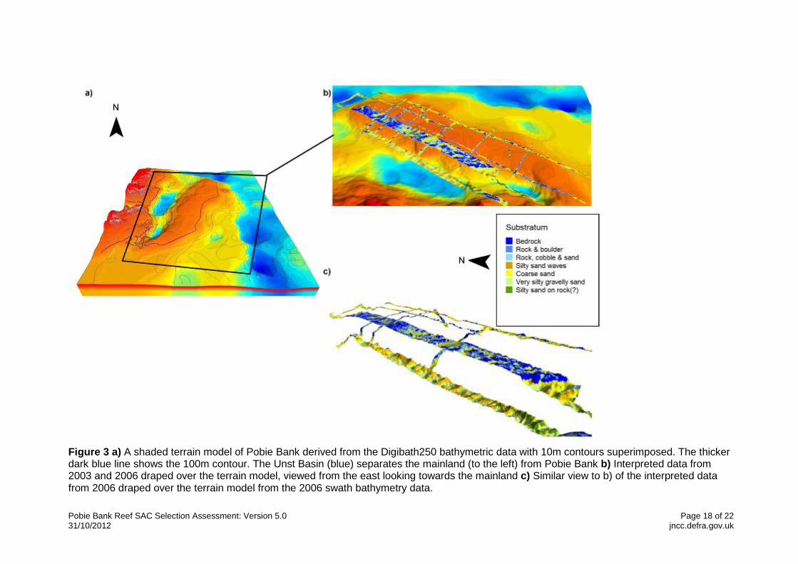
12. Site overview and conservation interest Pobie Bank is located to the east of the Shetland Isles in the Northern North Sea regional sea. The bedrock in this area is composed of Devonian red sandstones and blue siltstones forming the East of Shetland Platform (Green et al, 2008). These are underlain in the northwest of the cSAC by protruding, rugged metamorphic basement rocks. Ridges most likely created by moraines, run ENE to WSW across the cSAC and contain abundant cobbles on the crests (Green et al, 2008). Pobie Bank Reef candidate SAC is approximately 70km long (crest running NNE to SSW) and up to 21km wide. The depth within the cSAC ranges from 70m to over 100m; the average seabed depth within the site boundary is approximately 90m. Digibath 250 bathymetric contour data reveals that the western edge of the bank slopes steeply to approximately 130m depth into the Unst Basin, as it follows the line of the Pobie Bank Fault, and more gradually on the eastern edge to the same depth. Interpreted acoustic data, gathered from the SEA5 and SEA SAC 2006 surveys, draped over a terrain model shows bedrock and boulders are the predominant substratum on the shallower ground of Pobie Bank to about the 100m contour (Figure 3). These rocky outcrops are very rugged with sand between outcrops. Sand predominates as the substratum below 100m on the eastern edge. Although this sand may only be a thin layer over underlying rock, it could reduce the scope for epifaunal growth to a few scattered rocky outcrops. Large gravel and sand waves occur in the Unst Basin on the western edge (Foster-Smith et al, 2009). The bedrock and boulders provide reef habitat for a variety of species. Bedrock reef is more widespread on Pobie Bank Reef above 100m depth where the rugged rocky outcrops occur. Stony reef appears to predominate around the eastern margins of the bedrock, particularly in lower-lying ground between outcrops. Much of the cSAC is most accurately described as a mixture of these two reef types. Analysis of the SEA5 and SEA SAC 2006 video and stills data (Foster-Smith et al, 2009), reveal that the majority of biota on Pobie Bank Reef are faunal crust species and robust erect fauna. Encrusting bryozoan species are common including Cellepora pumicosa and Smittina landsborovii and encrusting sponges and hydroid and bryozoan turfs are also widespread. Serpulid worm species are present including Protula tubularis, Pomatoceros triqueter and Serpula vermicularis as well as spirorbid worms. The most widespread erect faunal species are the bryozoans, Omalosecosa ramulosa, the bracket sponge Axinella infundibuliformis and the branching sponges Raspalia hispida and Stelligera stuposa. The cup coral, Caryophyllia smithii, is also widespread. Other colonising species include the bryozoans, Reteporella beaniana, the gastropod, Calliostoma zizyphinum, the starfish Stichastrella rosea and Solaster endeca and the cushion star Hippasteria phrygiana. Silty sediment is only widespread on the eastern bank and this supports dense populations of Ophiura albida. Norway redfish Sebastes viviparus and Norway pout Trisopterus esmarkii are also in abundance in the region. Some rare species to the region were also present. This includes the sponge, Phakellia rugosa and one sighting of the fish, Icelus bicornis (Twohorn sculpin), both more common in Norway than in British waters, and the serpulid worm Ditrupa areatina, which forms dense aggregations in some areas of Pobie Bank Reef. In the shallower regions of Pobie Bank Reef (around 70m - 85m), rugged bedrock and stony (mostly composed of boulders) reef are present with sufficient light to sustain encrusting coralline algae. Some locations also support Alcyonium digitatum. Otherwise the fauna is similar to other rocky habitats on Pobie Bank Reef with a preponderance of encrusting bryozoans, sponges and Pomatoceros triqueter. These shallower sites represent the biotope CR.MCR.EcCr.FaAlCr. Where bedrock and stony reef occur in deeper waters (around 70m to 110m), the habitat is often mixed with sandy patches. Here the reef is largely dominated
Pobie Bank Reef SAC Selection Assessment: Version 5.0 Page 17 of 22 31/10/2012 jncc.defra.gov.uk
by encrusting sponges, bryozoans and Pomatoceros triqueter with low densities of Axinellid sponges. This represents the biotope CR.HCR.DpSp.PhaAxi. At more than 100m water depth, the habitat is largely composed of low lying, flat bedrock with a substantial covering of silty sand. Large numbers of Ophiura albida are present in the silt whilst the underlying rock supports small erect sponges and small numbers of Caryophyllia smithii. This is representative of the biotope CR.MCR.EcCr.CarSp. The circalittoral sediment around the bedrock outcrops is coarse and shelly, often in waves with shell and small stones in the troughs, representing the biotope SS.SCS.CCS. At the deeper eastern ridge of Pobie Bank Reef, circalittoral muddy sand, SS.SSa.CMuSa, is widespread.
Pobie Bank Reef SAC Selection Assessment: Version 5.0 Page 18 of 22 31/10/2012 jncc.defra.gov.uk
Figure 3 a) A shaded terrain model of Pobie Bank derived from the Digibath250 bathymetric data with 10m contours superimposed. The thicker dark blue line shows the 100m contour. The Unst Basin (blue) separates the mainland (to the left) from Pobie Bank b) Interpreted data from 2003 and 2006 draped over the terrain model, viewed from the east looking towards the mainland c) Similar view to b) of the interpreted data from 2006 draped over the terrain model from the 2006 swath bathymetry data.

Pobie Bank Reef SAC Selection Assessment: Version 5.0 Page 19 of 22 31/10/2012 jncc.defra.gov.uk
13. References CHESHER, J.A. 1984. Shetland Sheet 60°N-02°W Sea Bed Sediments and Quaternary Geology 1:250,000. British Geological Survey. COMMISSION OF THE EUROPEAN COMMUNITY (CEC). 2011. Natura 2000 Standard Data Form: Explanatory Notes. Brussels, European Commission DG Environment. Available from: http://eur-lex.europa.eu/LexUriServ/LexUriServ.do?uri=CELEX:32011D0484:EN:NOT [Accessed September 2012]. CONNOR, D.W., ALLEN, J.H., GOLDING, N., HOWELL, K.L., LIEBERKNECHT, L.M., NORTHEN, K.O., REKER, J.B. 2004. The Marine Habitat Classification for Britain and Ireland Version 04.05. Peterborough: JNCC. ISBN 1 861 07561 8. Available from: http://jncc.defra.gov.uk/MarineHabitatClassification [Accessed July 2012] DEFRA. 2004. Review of Marine Nature Conservation. Working Group Report to Government [online] London: Defra. DUCK, C. 2009. Grey seal pup production in Great Britain and Ireland in 2008. SCOS briefing paper 09/1. DUCK, C. & THOMPSON, D. 2009. The status of British common seal population in 2008. SCOS briefing paper 09/03. EVANS, P.G.H., ANDERWALD, P. & BAINES, M.E. 2003. UK Cetacean Status Review. Report to English Nature and the Countryside Council for Wales. FOSTER-SMITH, R., BENSON, A. & FOSTER-SMITH, J. 2009. Interpretation of Pobie Bank East of Shetland for Annex I Reef. JNCC Report No. 433. GAFEIRA, J., GREEN S., DOVE, D., MORANDO, A., COOPER, R., LONG, D.. and GATLIFF, R. W. (2010) Developing the necessary data layers for Marine Conservation Zone selection - Distribution of rock/hard substrate on the UK Continental Shelf: MB0103 Final Report for Defra. 78 pp. GREEN, S., LONG, D. AND COOPER, R. 2008. Geological Data Interpretation of the Reef East of Shetland (Pobie Bank) Area of Search (AoS). British Geological Survey Commercial Report, CR/08/128. 43pp. JNCC. 2004. The Irish Sea Pilot Final Report. Report to Defra by The Joint Nature Conservation Committee. Peterborough: JNCC. Available from: http://jncc.defra.gov.uk/page-2767#download [Accessed July 2012] JNCC. 2012. UK Guidance on defining boundaries for marine SACs for Annex I habitat sites fully detached from the coast [online]. Peterborough: JNCC. Available from: http://jncc.defra.gov.uk/pdf/SACHabBoundaryGuidance_2012Update.pdf [Accessed September 2012]. OWENS, R., GRAHAM, C., MCMILLAN, M., and RISE, L. 1984. Halibut Bank Sheet 60°N-00° Sea Bed Sediments 1:250,000. British Geological Survey and Continental Shelf Institute, Norway.

Pobie Bank Reef SAC Selection Assessment: Version 5.0 Page 20 of 22 31/10/2012 jncc.defra.gov.uk
MATTHIOPOULOS, J. 2007. Preliminary methods for designing marine SACs for UK pinnipeds on the basis of space use. SCOS 2007 Briefing Paper 07/8. MATTHIOPOULOS, J., MCCONNELL, B., DUCK, C. & FEDAK, M. 2004. Using satellite telemetry and aerial counts to estimate space use by grey seals around the British Isles. Journal of Applied Ecology, 41, 476-491. REID, J.B., EVANS, P.G.H. & NORTHRIDGE, S.P. 2003. Atlas of cetacean distribution in north-west European waters. Peterborough: JNCC. Available from: http://jncc.defra.gov.uk/page-2713 [Accessed July 2012] SCANS II, 2008. Small Cetaceans in the European Atlantic and North Sea. Final Report submitted to the European Commission under project LIFE04NAT/GB/000245. Available from http://biology.st-andrews.ac.uk/scans2/inner-finalReport.html [Accessed July 2012] SHARPLES, R.J., CUNNINGHAM, L. & HAMMOND, P.S., 2005. Distribution and movement of harbour seals around the UK. SCOS Briefing paper 05/5. STEVENSON, AG, and RUCKLEY, NA. 1998. Shetland Sheet 60°N-02°W Sea Bed Sediments, 1:250,000. British Geological Survey.

Pobie Bank Reef SAC Selection Assessment: Version 5.0 Page 21 of 22 31/10/2012 jncc.defra.gov.uk
Appendix 1: a) Supervised classification of the acoustic data from 2003 and 2006 superimposed on bathymetric contours. The dark blue line represents the 100m contour. b) The distribution of Annex I reef sub-habitats within the area of search, generated using analysis of acoustic data and interpolation techniques.

Pobie Bank Reef SAC Selection Assessment: Version 5.0 Page 22 of 22 31/10/2012 jncc.defra.gov.uk
Appendix 2: Confidence in Annex I habitat map based on differences in data used to develop the Annex I habitat map. Confidence was split into 3 levels and categorised as follows: 1) High - Annex I reef derived from acoustic data coverage and/or groundtruthing data; 2) Medium - Annex I reef derived from data interpolation techniques using mapping software; and 3) Low - Potential Annex I reef derived by extension of the reef feature into potential reef areas identified by BGS.