inside · a fine pairing—this 3d laser scanner is using terrestrial light detection and ranging...
TRANSCRIPT
FALL 2017
ModernHistory
Inside
www.cecinc.com
CEC’s professionals became engineers and scientists
because of their curiosity and desire to challenge their
capabilities. Performing projects that rely solely on one’s
experience does not consistently satisfy our professionals.
When our engineers and scientists are put to the test, and I
mean really put to the test, in some of our planet’s toughest,
most challenging environments—environments others may
determine to be time, cost, or otherwise prohibitive—they
flourish. Getting out of our comfort zone when possible
to help our clients allows us to flex our creativity, apply
new technologies, and exercise in new ways those deep
core principles that are the basis for truly sound technical
solutions. Delivering for clients in these scenarios
allows us to bring better, more ingenious solutions and
unconventional approaches back to the problems we solve
for CEC’s entire client base every day.
The projects described in this newsletter allowed our
professionals to challenge their capabilities to achieve
unique objectives.
No Boundaries
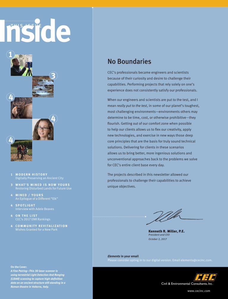
1 M O D E R N H I S T O R Y Digitally Preserving an Ancient City
3 W H AT ’ S M I N E D I S N O W Y O U R S Restoring Disturbed Lands for Future Use
4 M I N E D / Y O U R S An Epilogue of a Different “Elk”
4 S P O T L I G H T Interview with Adele Beaves
4 O N T H E L I S T CEC’s 2017 ENR Rankings
4 C O M M U N I T Y R E V I T A L I Z AT I O N Wishes Granted for a New Park
1
On the Cover:A Fine Pairing—This 3D laser scanner is using terrestrial Light Detection And Ranging (LiDAR) scanning to capture high-definition data on an ancient structure still standing in a Roman theatre in Volterra, Italy.
3
4
4
Kenneth R. Miller, P.E.President and CEO
October 2, 2017
Elements in your email Please consider opting in to our digital version. Email [email protected].
4
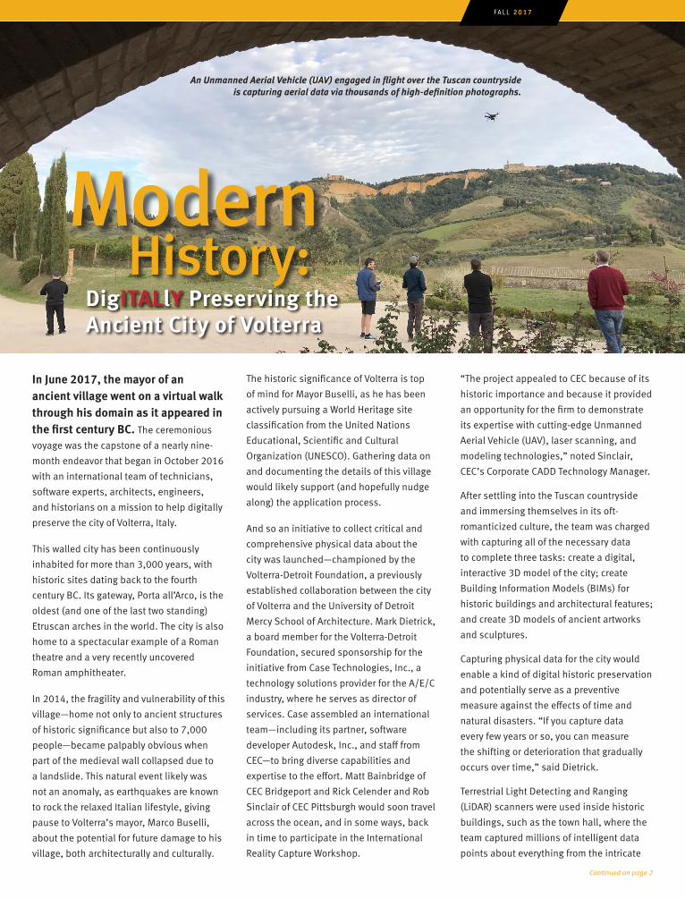
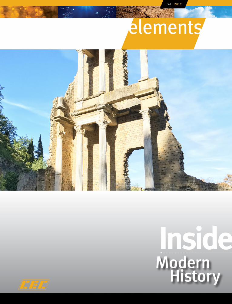
In June 2017, the mayor of an ancient village went on a virtual walk through his domain as it appeared in the first century BC. The ceremonious
voyage was the capstone of a nearly nine-
month endeavor that began in October 2016
with an international team of technicians,
software experts, architects, engineers,
and historians on a mission to help digitally
preserve the city of Volterra, Italy.
This walled city has been continuously
inhabited for more than 3,000 years, with
historic sites dating back to the fourth
century BC. Its gateway, Porta all’Arco, is the
oldest (and one of the last two standing)
Etruscan arches in the world. The city is also
home to a spectacular example of a Roman
theatre and a very recently uncovered
Roman amphitheater.
In 2014, the fragility and vulnerability of this
village—home not only to ancient structures
of historic significance but also to 7,000
people—became palpably obvious when
part of the medieval wall collapsed due to
a landslide. This natural event likely was
not an anomaly, as earthquakes are known
to rock the relaxed Italian lifestyle, giving
pause to Volterra’s mayor, Marco Buselli,
about the potential for future damage to his
village, both architecturally and culturally.
An Unmanned Aerial Vehicle (UAV) engaged in flight over the Tuscan countryside is capturing aerial data via thousands of high-definition photographs.
The historic significance of Volterra is top
of mind for Mayor Buselli, as he has been
actively pursuing a World Heritage site
classification from the United Nations
Educational, Scientific and Cultural
Organization (UNESCO). Gathering data on
and documenting the details of this village
would likely support (and hopefully nudge
along) the application process.
And so an initiative to collect critical and
comprehensive physical data about the
city was launched—championed by the
Volterra-Detroit Foundation, a previously
established collaboration between the city
of Volterra and the University of Detroit
Mercy School of Architecture. Mark Dietrick,
a board member for the Volterra-Detroit
Foundation, secured sponsorship for the
initiative from Case Technologies, Inc., a
technology solutions provider for the A/E/C
industry, where he serves as director of
services. Case assembled an international
team—including its partner, software
developer Autodesk, Inc., and staff from
CEC—to bring diverse capabilities and
expertise to the effort. Matt Bainbridge of
CEC Bridgeport and Rick Celender and Rob
Sinclair of CEC Pittsburgh would soon travel
across the ocean, and in some ways, back
in time to participate in the International
Reality Capture Workshop.
“The project appealed to CEC because of its
historic importance and because it provided
an opportunity for the firm to demonstrate
its expertise with cutting-edge Unmanned
Aerial Vehicle (UAV), laser scanning, and
modeling technologies,” noted Sinclair,
CEC’s Corporate CADD Technology Manager.
After settling into the Tuscan countryside
and immersing themselves in its oft-
romanticized culture, the team was charged
with capturing all of the necessary data
to complete three tasks: create a digital,
interactive 3D model of the city; create
Building Information Models (BIMs) for
historic buildings and architectural features;
and create 3D models of ancient artworks
and sculptures.
Capturing physical data for the city would
enable a kind of digital historic preservation
and potentially serve as a preventive
measure against the effects of time and
natural disasters. “If you capture data
every few years or so, you can measure
the shifting or deterioration that gradually
occurs over time,” said Dietrick.
Terrestrial Light Detecting and Ranging
(LiDAR) scanners were used inside historic
buildings, such as the town hall, where the
team captured millions of intelligent data
points about everything from the intricate
FALL 2017
ModernDigITALlY Preserving the Ancient City of Volterra
Continued on page 2
History:
artwork on the ceilings to the tiniest of
cracks in a pillar. The points were used to
create detailed 3D models of the structures
and their features, as well as a BIM, which
becomes a useful tool for architects and
planners should there ever be maintenance,
restoration, or retrofitting needed as time
decays the architecture. LiDAR scanners
were also used outside, as was the case in
the Roman theatre, which alone required
120 individual scan locations to capture all
of the data for a complete model.
Aerial data on the archaeological sites and
ancient historical structures inside the city
wall were captured using UAVs (aka drones)
with mounted cameras. The data were then
processed into point clouds and 3D models
using photogrammetry (stitching together
photos into a continuous image). These
models may eventually be combined with
geographic information system (GIS) visuals
such as land surface, roads, and rivers to
create more complete georeferenced 3D
digital models.
Finally, objects in Volterra’s museums and
architectural details from around the city
were captured with high-resolution digital
cameras (and, frankly, even iPhones) and
converted to 3D models. The models of the
artifacts will be used in virtual exhibitions,
for research, and for conservation efforts.
They can also be replicated using 3D
printers for educational purposes or should
the need arise for a tangible version.
Every evening, the team processed data
captured during the day. “We took the point
clouds and created a mesh, which turns the
point cloud into a 3D model. From there, we
can take the mesh data and incorporate it
into AutoCAD® Civil 3D® or Revit® to create
an as-built model,” noted Sinclair. “We can
truly recreate the space—put details in, tag
it with data, etc. All the measurements of
the BIM were based off the point cloud or
mesh we created.” The processing of data
continued in the months that followed
the workshop.
When representatives from Case, Autodesk,
and the Volterra-Detroit Foundation
returned in June, they took with them a few
interactive models and 3D-printed physical
replicas for a presentation in the town hall.
Mayor Buselli, his staff, city residents, and
representatives from UNESCO were treated
to a virtual reality (VR) demo that mimicked
walking through Volterra’s historical sites,
including a chance to experience a fully
recreated Roman theatre in its original glory.
The public also was invited to experience
the models throughout the month of July.
The team plans to launch an interactive
website and online virtual gallery in the
coming weeks so that all products created
from the captured data can be viewed by
anyone, anywhere. And though the mayor
has not yet received word on his World
Heritage site classification from UNESCO,
it is evident that there is a great deal of
interest in opening Volterra to the world and
in making sure its heritage is preserved for
generations to come. ■
Continued from page 1
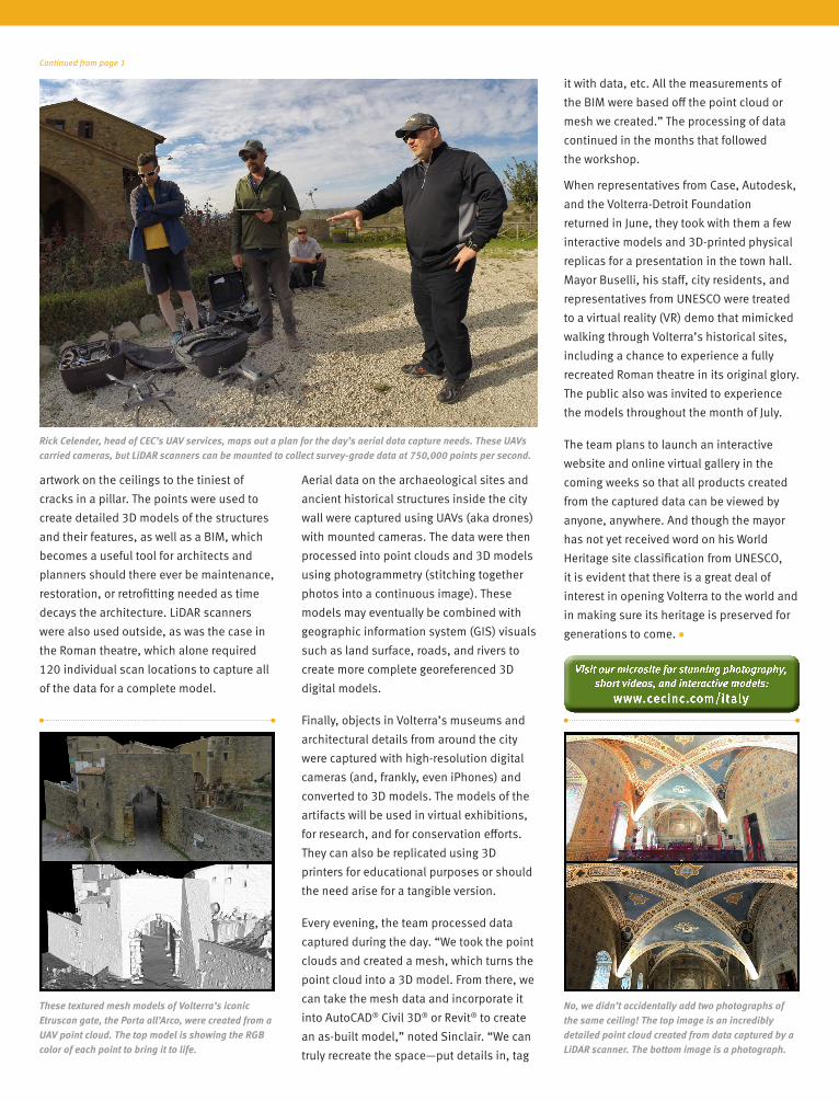
Rick Celender, head of CEC’s UAV services, maps out a plan for the day’s aerial data capture needs. These UAVs carried cameras, but LiDAR scanners can be mounted to collect survey-grade data at 750,000 points per second.
These textured mesh models of Volterra’s iconic Etruscan gate, the Porta all’Arco, were created from a UAV point cloud. The top model is showing the RGB color of each point to bring it to life.
No, we didn’t accidentally add two photographs of the same ceiling! The top image is an incredibly detailed point cloud created from data captured by a LiDAR scanner. The bottom image is a photograph.
Visit our microsite for stunning photography, short videos, and interactive models:
www.cecinc.com/italy
Coal mining operations in a state with terrain as complex as West Virginia’s involve creative extraction methods, including doing so atop mountains with unusually steep slopes. As difficult as they may be to mine, these sites can prove even more difficult to reclaim when operations are complete
Further, to obtain a new environmental permit to begin extracting resources in the first place, mining companies need proof they will offset their unavoidable impacts to the landscape, and will do so in the same watershed as their intended operations.
To that end, many companies now look to mitigation banks for said proof, which comes in the form of credits. Why mitigation banks? Because organizations like the U.S. Army Corps of Engineers have stated that obtaining credits from a reputable mitigation bank is the most preferred method of mitigation, not the company’s own permittee-responsible mitigation. And because they free the mining company to focus on what it does best: mine coal.
When mitigation banking sponsor Ecosystem Investment Partners, LLC, (EIP) opted to provide a thoughtful and balanced option to reclaim previously surface-mined and deep-mined coal sites in West Virginia and then offer those restored sites as options for offsetting future impacts to sites, a kind of benefit loop ensued: mine reclamation as an enabler of future mining operations.
In 2014, EIP purchased three properties totaling roughly 10,000 acres, including 85 miles of streams, for a new mitigation bank in the Guyandotte and Tug Fork River watersheds in West Virginia. The bank would be developed in partnership with the Canaan Valley Institute, an organization dedicated to improving water quality in the central Appalachian region.
Where others might have opted to restore an easily accessible river, EIP specifically targeted these three properties. “We thought, ‘Let’s mitigate the impact on the same stream types likely to be affected as a way to restore equal balance,’ ” said Katherine Birnie, Managing Director of EIP. The project would be the largest stream mitigation bank ever created in West Virginia.
Geomorphologist Nate Ober, an ecosystem restoration expert in CEC’s Bridgeport, W.Va., office, led the project design. “All of the EIP properties required not only mine reclamation but also stream restoration to reconnect, reestablish, and enhance ephemeral, intermittent, and perennial streams disturbed and disconnected by industry,” noted Ober. “The project posed unique challenges compared with other mitigation banks. First, reforestation had somewhat masked the underlying land and stream disturbance. Second, we were looking at slopes pushing 70% with headwaters streams cascading down the hillsides. No one else is doing stream restoration at those kinds of slopes.”
“We continue to seek out CEC for these demanding sites,” Birnie explained. “The volume Nate has designed is unmatched, and his work has been groundbreaking in terms of the way it’s been done.”
Because the properties consisted largely of steep terrain, special restoration techniques were devised to restore stream reaches. “We had bulldozers safely but delicately navigating the steep hillsides. The contractors used a cable system and were, in a sense, ‘yo-yoing’ in a stair-step pattern down the mountainside,” Ober recalled. “We truly pushed the limits on what you can do from a stream restoration standpoint.” The project team ultimately developed innovative mitigation credit options for reforested, steeply sloped sites—options now being considered as models for similar mitigation projects. ■
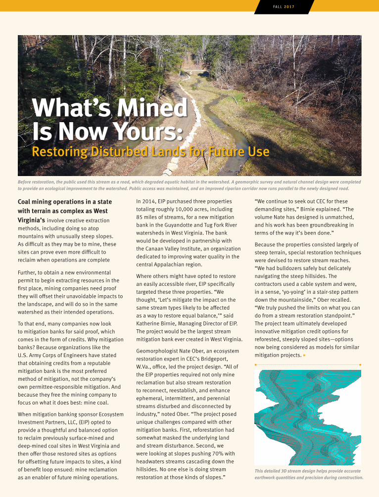
Before restoration, the public used this stream as a road, which degraded aquatic habitat in the watershed. A geomorphic survey and natural channel design were completed to provide an ecological improvement to the watershed. Public access was maintained, and an improved riparian corridor now runs parallel to the newly designed road.
What’s Mined Is Now Yours:
FALL 2017
Restoring Disturbed Lands for Future Use
This detailed 3D stream design helps provide accurate earthwork quantities and precision during construction.
Spotlight:Q What will be your focus areas
now that you are leading CEC’s Civil Engineering practice?
A First, Steve Donaldson has been a consistent, steadfast ambassador for the civil group and a mentor to
me for the 17 years I’ve been with CEC. It will be difficult to fill his shoes. People have placed a tremendous amount of trust in him and have felt like they could turn to him for guidance. It will be my charge to become that person for others. I also want to focus on education and development so our staff can continue to achieve the highest level of technical competency. What I will also do, hopefully, is lead the effort to incorporate emerging technologies and tools into our daily practice, such as new AutoCAD 3D tools and InfraWorks,® augmented/virtual reality (AR/VR), BIM, LiDAR scanning, and drone applications. I’m excited to use these tools, but I’m still wary of those who use technology simply to say they’re using it and don’t truly understand the fundamentals of it. We must carefully consider how new technologies will help us do our jobs more efficiently and effectively to save our clients time and resources.
Q Is there a way to evolve what is arguably the oldest engineering discipline?
A One of my favorite things about working in this discipline is driving around town after so many years
and being able to say ‘I designed that.’
A Civil Exchange with Principal Adele Beaves
I’m using the things that I designed in my daily life. Civil engineering doesn’t need any bells and whistles; it is the foundation from which our world was built. I don’t want to forget our purpose or get too flashy, but I also want to be sure we’re staying on the leading edge. That said, we do have to continuously improve, and we can do that by incorporating elements of new technology and design with well-established science-based methodologies. Always at the heart of it are good engineering principles, but we can set ourselves apart by being principled engineers who are technologically savvy and have an understanding of design.
Q How would you go about changing people’s perceptions of civil engineering firms?
A I’d like to continue opening people’s minds to the concept that, in addition to being engineers, we are
design professionals. We know what it means to design and what good design means. Because we work closely with architects, we need to speak that language and have that same mentality. There’s a design process—it’s iterative, it’s collaborative, it’s testing things out, it’s thinking about more than just ‘Point A to Point B’ in solving a problem. It’s asking ourselves, ‘Is our solution elegant, efficient, artistic, and environmentally friendly? Does the design do the most good for the most people? Does the design speak to people?’ It’s about evoking an experience for the user.
EIP typically opens its restored habitats to the public for recreational activities, such as hiking, hunting, and fishing. For the three reclaimed mine sites in the Guyandotte and Tug Fork River watersheds, EIP is currently leasing the acreage to the West Virginia Division of Natural Resources (WVDNR), which may eventually purchase the land to ensure long-term public access. But the WVDNR had been looking for large areas of land for something more: an elk reintroduction plan. Last fall, dozens of elk, which have not been seen in the state since 1875, were brought from Kentucky and released on one of the properties, now named the Tomblin Wildlife Management Area. It was the first-ever elk release in West Virginia. The WVDNR hopes to establish a population large enough to allow for hunting, but expects the release to benefit both hunters and non-hunters alike, as the elk are a draw for wildlife enthusiasts, too. In June of 2017, an elk calf was born, the first since the reintroduction, according to the WVDNR.
The environment that makes mining, mine reclamation, and ecosystem restoration a challenging endeavor is the very same environment that makes recreation and outdoor activity appealing, and creates prime habitat for a variety of wildlife species—even those that had once vanished. ■
In July of 2017, Adele Beaves, P.E., CPESC, became the new corporate civil practice lead for CEC. She takes over for Steve Donaldson, P.E., P.L.S., who led the civil group for more than 20 years.
The story continues ...
Community Revitalization:
#125 TOP 500 DESIGN FIRMS#95 TOP 200 ENVIRONMENTAL FIRMS
Ranked on 8 of ENR’s Top Market Sector lists:
ON THE LIST2017 ENR RANKINGS
#7 SOLID WASTE#9 MINING#9 CLEAN AIR COMPLIANCE#23 PIPELINES#25 REFINERIES & PETROCHEMICAL PLANTS#30 SEWER & WASTE#45 PETROLEUM#47 HAZARDOUS WASTE
= 1St Appearance!
An Epilogue of a Different “Elk”
Mined/Yours:
Elements is published by Civil & Environmental Consultants, Inc. for clients, business partners, and other associates.
Civil & Environmental Consultants, Inc. 333 Baldwin Road Pittsburgh, PA 15205 www.cecinc.com
E M I LY C H I O D O | Editor/Writer
T A R A K I R K M A N | Art Director/Design
P H O T O C R E D I T S
Rick Celender Kelsey KanspedosEmily McElroyNate OberRob Sinclair
Special thanks to Kyle McCardle and Rob Sinclair for their assistance with the preparation of CEC’s Italy microsite.
For information, address changes, corrections, or additions to the mail or email list, contact 1.800.365.2324 or email [email protected].
O F F I CES
Austin, TXBoston, MABridgeport, WVCharlotte, NCChicago, ILCincinnati, OHColumbus, OHExport, PAGreenville, SCIndianapolis, INKnoxville, TNNashville, TNPhiladelphia, PAPhoenix, AZPittsburgh, PA (Headquarters)Sayre, PASevierville, TNSt. Louis, MOToledo, OH
Back Cover:PHOTO CONTEST WINNERBRYCE RANDALL / BRIDGEPORT
CEC sponsors a Photo-of-the-Month contest encouraging employees to submit photos from their work sites. The winning photo is published on CEC’s internal website and social media pages.
XX% Total Recycled Fiber
XX% Total Recycled Fiber
You can hire architects from anywhere in the world for their expertise, but there’s a general misconception that, when it comes to civil engineering firms, it’s only beneficial to hire the local guy down the street from the regulator’s office who knows the local process. Sure it’s important to have those relationships locally and to have people who know the terrain performing the work—but there’s more to it than that. Civil engineers are quite integral to the design team. Choose a firm that knows your product and process and that will bring an extra level of service. My goal is for clients to always say, ‘We need XYZ International Architecture Firm on the team and we also need CEC because they understand us.’
Q There are several new regional leaders in the civil practice. What was the impetus?
A We’ve always wanted to grow the practice nationally. The timing was right recently as several market
sectors within the real estate development industry are in growth mode right now after having been stagnant for several years. This growth has allowed us to bring on great people in Greenville, Chicago, Austin, Boston, Bridgeport, and Phoenix with lots of experience who were looking for change. We often find people who were not previously in an environment that enabled their growth or their ability to build client relationships. Our business model is appealing to people who want to be engaged in business development
and who have the motivation to build a robust practice in their region. I want to make sure our local leads have the resources and support they need—a network of people working together with the strength of a big company behind them.
Q What is a current development trend and how can CEC help clients meet their objectives?
A Urban infill and redevelopment. In most of the markets where there is a CEC office, there’s a lot
of existing underutilized property and aging infrastructure that could be repurposed and revitalized. We can tackle complex urban projects by combining the expertise of our civil engineers with that of our GIS and survey teams; our geotechnical, transportation, and structural engineers; and our experts in site infrastructure maintenance, property condition assessments, and green infrastructure design. I’m also excited to collaborate with our burgeoning economic master planning group to experience how projects come to life, how funding is created, and how the public and private sectors can work together to encourage development. We can pull all of these disciplines into the fold to deliver integrated, seamless projects. It’s just one of the many things that differentiates CEC from other firms. ■
FALL 2017
The City of Ethridge in Lawrence County, Tennessee, has been working hard to apply for grants that will help revitalize the community. The city opted to begin its revitalization with a community park that would create a central and safe environment for residents and children. CEC designed a conceptual master plan for the park, divided into phases based on each park element—making it easy to target specific grants. In July, a ribbon-cutting ceremony was held for the completion of the first phase. CEC Nashville Project Manager Kelsey Kanspedos was invited to participate in the ceremony. ■
Community Revitalization:
Civil Engineering | Ecological Sciences | Environmental Engineering & Sciences | Survey | Waste Management | Water Resources
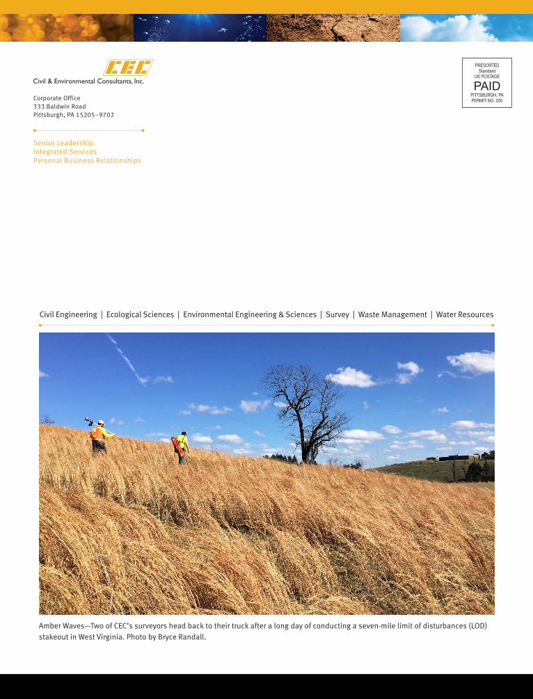
Amber Waves—Two of CEC’s surveyors head back to their truck after a long day of conducting a seven-mile limit of disturbances (LOD) stakeout in West Virginia. Photo by Bryce Randall.
Corporate Office333 Baldwin RoadPittsburgh, PA 15205–9702
Senior LeadershipIntegrated ServicesPersonal Business Relationships