insights into the dprk military threat gained from
TRANSCRIPT

Insights into the DPRK Military Threat Gained From Commercial
Satellite Imageryby
Thomas B. Cochran and Matthew G. McKinzie
Presented at the54th Pugwash Conference on Science and World Affairs
Seoul, Republic of Korea
4-9 October 2004

NRDC Geo-Spatial Database of North Koreaa new research tool to analyze
security and human rights issues
• High resolution commercial satellite imagery – first available to non-governmental researchers in 1999
• Ikonos (Space Imaging) – sun-synchronous, 98-minute orbit – produces a color photo at one-meter resolution
• QuickBird (DigitalGlobe) – can achieve 61-centimeter resolution under some conditions.
• Today’s commercially available imagery is comparable to U.S. intelligence community of early 1970s
• Computing power – current laptops have speed and memory comparable to the Cray II that went to LLNL in 1985
• New research can refine military estimates, provide additional verification by the public
NRDC’s Database of Military and Other Features in the DPRK (about 3,700 Records).
In Red: NRDC DatabaseRecords

Democratic Peoples Republic of KoreaBasic Facts
• Occupies 120,000 sq km – slightly smaller than Mississippi or Fujianprovince
• Population 22,700,000• Coastline – 2,495 km• Borders - Russia (19
km), China (1,416 km), ROK (238 km DMZ)
• DMZ – extends 2 km on either side of a military demarcation line for 238 km from the Yellow Sea to the Sea of Japan
LandSat7 Image of the DPRK Capital, P’yongyang, built along the Taedong River.

DPRK Military FactsMost militaristic state in the world…
• 23% of GDP for military ($5.2 billion in 2002) (ROK 4%)
• 40 of 1,000 are in uniform (ROK 14 of 1,000)
• 1,200,000 active forces, 5,000,000 reserve, 4th largest in the world
• Army, Air Force, Navy and Special Operations Force (SOF)
• Military strategy – 1) reunify Korean Peninsula under North Korean control within 30 days of the beginning of hostilities 2) defend North Korea
• Most important facilities underground • DPRK Steadily Building a Nuclear
Weapons CapabilityDigitalGlobe photo of “JucheTower,” P’yongyang.

DPRK: an Underground Nation and MilitaryAfter the Korean War experience, Kim Il Sung said:
“The entire nation must be made into a fortress.”• The degree to which the DPRK military
is based underground is unique in the world – takes advantage of mountainous topography;
• Virtually everything of military significance is underground – several hundred large facilities, more than 10,000 smaller facilities;
• It is reported that thousands of artillery pieces are at underground sites; four tunnels have been discovered under the DMZ;
• Concealment of their military infrastructure from satellites and aerial reconnaissance make it an intelligence challenge;
• A verification nightmare for agreements limiting nuclear or other military developments in the DPRK.
Red: Airbases where NRDC has Observed Underground Hangers in SatphotosBlue: Navy Bases where NRDC has Observed Waterfront Caves/Tunnelsin Satphotos

Underground Air ForceNineteen air bases that have associated underground aircraft hangers
• Airfield Name CoordinatesLatitude Longitude
• Changjin-up Air Base 40 21 51.9 127 15 50.1• Hwangju Air Base 38 39 13.3 125 47 17.3• Hwangsuwon Air Base 40 40 56.0 128 08 55.5• Hyon-ri Air Base 38 36 47.8 127 27 04.5• Iwon Air Base 40 21 37.9 128 43 08.4• Koksan Air Base 38 41 19.5 126 36 08.4• Kuum-ni Air Base 38 51 55.1 127 54 12.6• Kwail Air Base 38 25 32.2 125 01 09.4• Nuchon-ni Air Base 38 14 16.7 126 07 13.4• Onch'on Air Base Auxiliary Airstrip 38 53 14.0 125 16 49.9• Orang Air Base 41 25 45.3 129 38 52.7• Panghyon Air Base 39 55 38.4 125 12 28.1• Pukch’ang Air Base 39 30 16.5 125 57 52.9• Sunan Air Base/International Airport 39 12 25.7 125 40 09.8• Sunch’on Air Base 39 24 41.8 125 53 27.5• Taet'an Air Base 38 07 50.4 125 14 43.1 • Toksan Air Base 39 59 47.8 127 36 43.3• U'iju Air Base 40 09 00.4 124 29 50.9• Wonsan Air Base 39 09 56.4 127 29 06.9

Underground NavyNavy Bases with Submarine Caves
Coordinates• Ch'aho-nodongjagu Navy Base
Entrance (1) 40 12 15N 128 39 00EEntrance (2) 40 12 06N 128 39 03E
• Kosong Naval FacilityEntrance (1) 38 44 04N 128 12 45E Entrance (2) 38 44 00N 128 12 44E
• Namae-ri Navy BaseEntrance 38 48 12N 128 08 17E
• Puam-dong Navy BaseEntrance (1) 41 19 18N 129 46 05EEntrance (2)` 41 19 30N 129 46 12E
• Songjin pando Navy BaseEntrance 39 22 18N 127 26 18E
• Yoho’ri Naval FacilityEntrance (1) 39 52 33N 127 47 39E Entrance (2) 39 52 39N 128 47 17E

Other Underground Facilities(Purpose Unknown)
• Haqap 40 04 54N; 126 11 22E
• Kumchang-ni 40 06 43N; 125 07 47E(under construction)
• Other suspect underground facilities, whose locations are not publicly known, are cited in the literature
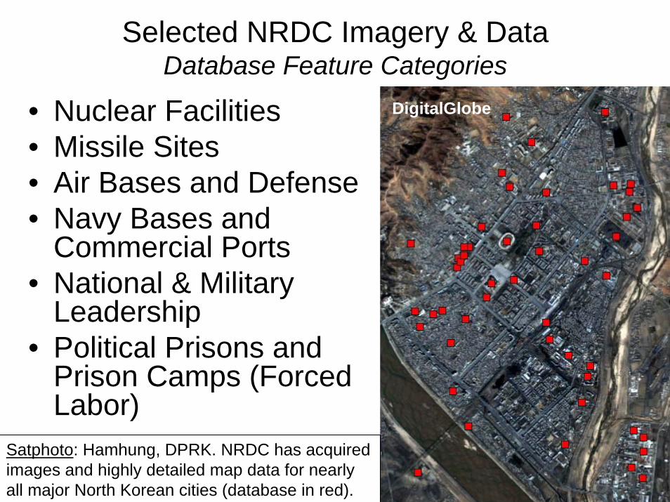
Selected NRDC Imagery & DataDatabase Feature Categories
• Nuclear Facilities • Missile Sites• Air Bases and Defense• Navy Bases and
Commercial Ports• National & Military
Leadership• Political Prisons and
Prison Camps (Forced Labor)
Satphoto: Hamhung, DPRK. NRDC has acquired images and highly detailed map data for nearly all major North Korean cities (database in red).
DigitalGlobe

Key DPRK Nuclear Sites
• Yongbyon Nuclear Research Center
• T’aech’on 200 MWeGraphite Nuclear Reactor (Unfinished)
• P’yongsan Uranium Concentrate Plant
• Pakch’on Uranium Concentrate Plant
Green: Uranium Ore Concentrate Plants


Yongbyon Graphite Reactor
Image Acquired: 13 August 2002 (IKONOS)
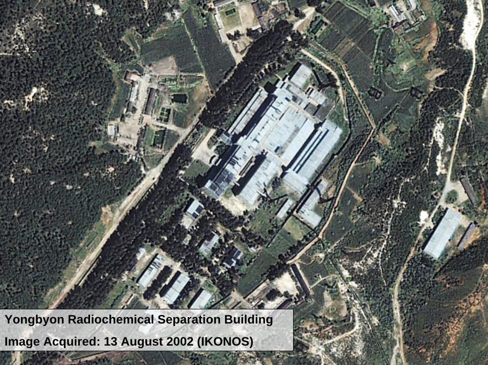
Yongbyon Radiochemical Separation Building
Image Acquired: 13 August 2002 (IKONOS)

16 June 2002
(IKONOS)
8 December 2003
(QuickBird)
T’aech’on Nuclear Reactor (200 MWe Graphite, Unfinished)

P’yongsan Uranium Concentrate Plant
Image Acquired: 10 March 2003
Nam-ch’on River

Pakch’on Uranium Concentrate Plant
Image Acquired: 10 March 2003
TaeryongRiver

DPRK Missile Sites
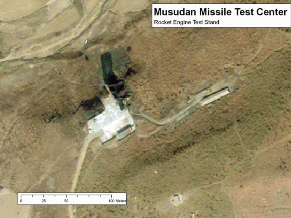
Many missile bases are cited in the literature, but only the Musudan test facility has been identified in satellite imagery.

Ballistic Missile Test Site
Musudan Missile Test Center

Musudan: Closeup

DPRK Airbases
and Air Defense
Major DPRK Airbases in Red; Minor Airfields in Yellow**
**Numerous highway landing strips and heliports excluded.


iG-23 Floggers (1 C
25 50 100 Meters


Uiju Airbase: OverviewU’iju Air Base
Image Acquired: 05 May 2002

U’iju Air Base: ZoomU’iju Air Base
Image Acquired: 05 May 2002
Entrances to Underground Hangars

Wonsan Air Base: OverviewWonsan Air Base
Image Acquired: 22 November 2002

Wonsan Air Base: Zoom
Wonsan Air Base
Image Acquired: 22 November 2002
Entrances to Underground Hangars

An Extensive Air Defense Network
Haeju, DPRK
Image Acquired: 02 February 2003

Haeju Air Defense Site, DPRK
Image Acquired: 02 February 2003

DRPK Navy Bases
• Mayang-do Navy Base (23 Subs Observed in Satellite Imagery)
• Ch’aho-nodongjaguNavy Base (14 Subs)
• Pip’a-got Navy Base (9 Subs)
DPRK Navy Bases in Red

Mayang-do Navy Base: OverviewMayang-do Navy Base
Image Acquired: 06 September 2002
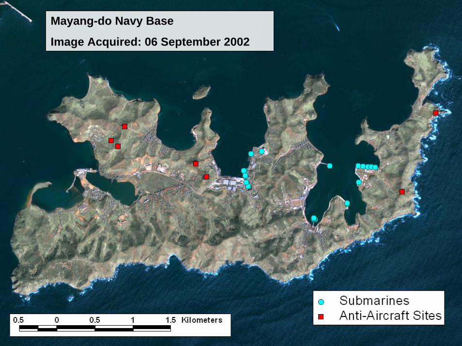
Mayang-do Navy Base: AnnotationMayang-do Navy Base
Image Acquired: 06 September 2002

Mayang-do Navy Base: ZoomMayang-do Navy Base
Image Acquired: 06 September 2002
Romeo or Whiskey Class
Diesel-Powered Submarines
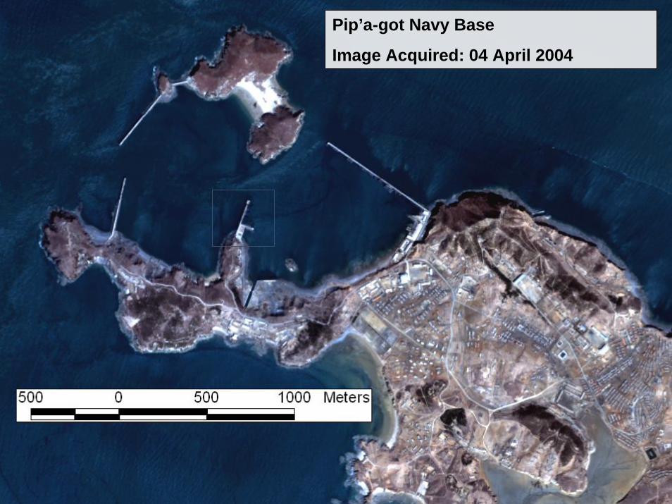
Pip’a-got Navy Base: OverviewPip’a-got Navy Base
Image Acquired: 04 April 2004

Pip’a-got Navy Base: ZoomPip’a-got Navy Base
Image Acquired: 04 April 2004
Coastal Sang-O Class
Diesel-Powered Submarines
Romeo Diesel-Powered Submarines

Puam-dong Navy Base 1. Shore Facilities 2. Entrance (2) to Underground Naval Facility 3. Entrance (1) to Undergr"-""1 Naval Facility 4. Boat ram^
0 125 250 500 Meters

I Entrance (1) to Underground Navv Facility

. 1 0 50 100 200 Meter

Wharf Area
Red: Visible ibmarines (14)
Entrance tc Cave (1)
ntrance to ,-,\

Sang-0 Class Submarines
Komeo (or wnisKey) m ..lass Snhmarines I
h'aho-nodongjag ge Source: DigitalGlobe
otoqraphed June 29, 2002
I =nlrance I0 Cave m I
I I
0 50 100 200 Meter
u Navy Base
Jmeo (or Whiskey) ' . class Submarines

Ch’aho-nodongiagu Navy Base: Zoom
Ch’aho-nodongjagu Navy Base
Image Acquired: 29 June 2002
Coastal Sang-O Class
Diesel-Powered Submarines
Romeo
Diesel-Powered
Submarines

' I . 50 ' 100 Meters I
Borneo (or Whiskey Class Submarines 1
1 LllllealllJG 1U
Cave (2)
Romeo (or Whiskey) Class Submarine

Kosong Navy Facility Image Source. DigitalGlobe Photographed April 26, 2003

-
Kosong Navy Facility 1

Boat Ramp:
Namae-ri Navy Bas1 Image Source: DigitalGlobe Photographed May 19,2003
Breakwater:
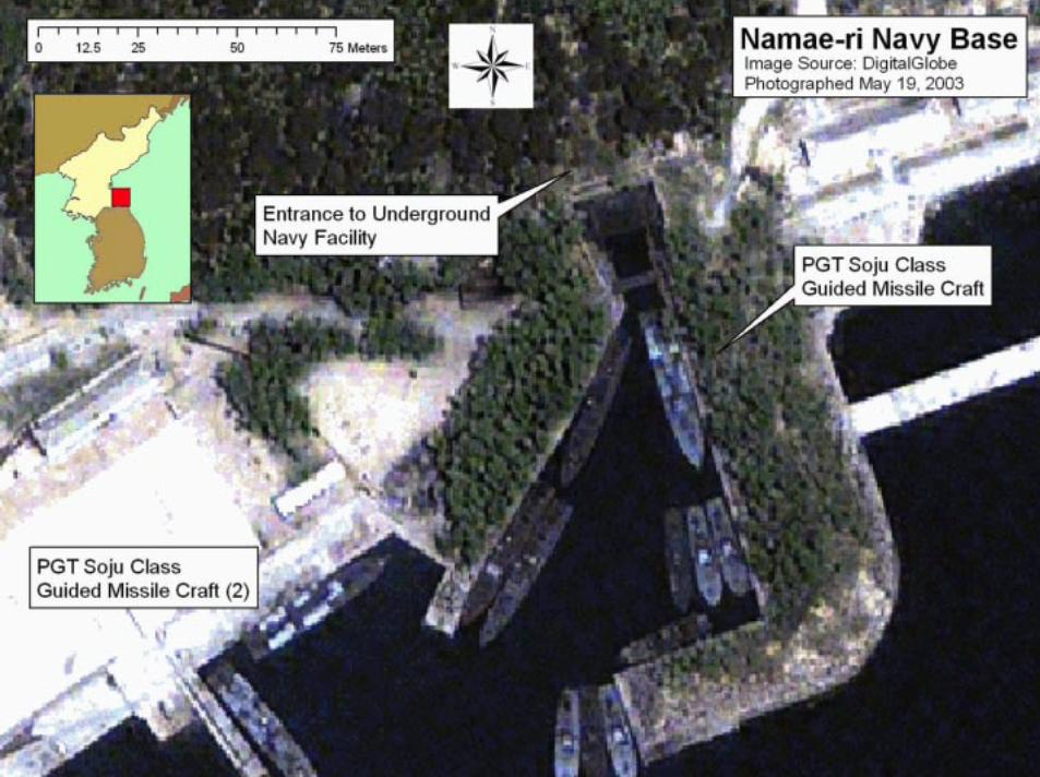
0 12.5 25 50 75 Meters 1
1 Guided Missile Craft (2) 1
- entrance to Underground qavy Facility 1
Namae-ri Navy Base Image Source: DigitalGlobe Photographed May 19,2003

National and Provincial
Government and Leadership
Sites
People’s Study PalaceForeign Ministry and
Cabinet OfficesKorean Workers’ Party
Complex
DPRK Leadership Sites in Purple

People’s Study Palace (left); Foreign Ministry and Cabinet Offices (right)
P’yongyang, DPRK
Image Acquired: 28 January 2002

Korean Workers’ Party Complex, P’yongyang
Image Acquired: 28 January 2002

DPRK Political Prisons and
Prison Camps (Forced Labor)

Kyo-hwa-so No- 1 Overview

Conclusion SlideCurrent Projects and Future Work…
We have found this tool very useful and we would be interested in collaborating with other institutions;
Arms control, energy and humanitarian issues.