inspire data specification on administrative units – guidelines
TRANSCRIPT

INSPIRE Infrastructure for Spatial Information in Europe
D2.8.I.4 INSPIRE Data Specification on Administrative units – Guidelines
Title D2.8.I.4 INSPIRE Data Specification on Administrative units – Guidelines
Creator INSPIRE Thematic Working Group Administrative units
Date 2009-09-07
Subject INSPIRE Data Specification for the spatial data theme Administrative units
Publisher INSPIRE Thematic Working Group Administrative units
Type Text
Description This document describes the INSPIRE Data Specification for the theme Administrative units
Contributor Members of the INSPIRE Thematic Working Group Administrative units
Format Portable Document Format (pdf)
Source
Rights public
Identifier INSPIRE_DataSpecification_AU_v3.0.pdf
Language En
Relation Directive 2007/2/EC of the European Parliament and of the Council of 14 March 2007 establishing an Infrastructure for Spatial Information in the European Community (INSPIRE)
Coverage Project duration

INSPIRE Reference: INSPIRE_DataSpecification_AU_v3.0.docpdfTWG-AU Data Specification on Administrative units 2009-09-07 Page II
Foreword How to read the document? This guideline describes the INSPIRE Data Specification on Administrative units as developed by the Thematic Working Group Administrative units using both natural and a conceptual schema languages. The data specification is based on the agreed common INSPIRE data specification template. The guideline contains detailed technical documentation of the data specification highlighting the mandatory and the recommended elements related to the implementation of INSPIRE. The technical provisions and the underlying concepts are often illustrated by examples. Smaller examples are within the text of the specification, while longer explanatory examples are attached in the annexes. The technical details are expected to be of prime interest to those organisations that are/will be responsible for implementing INSPIRE within the field of Administrative units. At the beginning of the document, two executive summaries are included that provide a quick overview of the INSPIRE data specification process in general, and the content of the data specification on Administrative units in particular. We highly recommend that managers, decision makers, and all those new to the INSPIRE process and/or information modelling should read these executive summaries first. The UML diagrams (in Chapter 5) offer a rapid way to see the main elements of the specifications and their relationships. Chapter 5 also contains the Feature Catalogue including the definition of the spatial object types, attributes, and relationships. People having thematic expertise but not familiar with UML can fully understand the content of the data model focusing on the Feature Catalogue. Users might also find the Feature Catalogue especially useful to check if it contains the data necessary for the applications that they run.
The document will be publicly available as a ‘non-paper’. It does not represent an official position of the European Commission, and as such can not be invoked in the context of legal procedures.
Legal Notice Neither the European Commission nor any person acting on behalf of the Commission is responsible for the use which might be made of this publication.

INSPIRE Reference: INSPIRE_DataSpecification_AU_v3.0.docpdfTWG-AU Data Specification on Administrative units 2009-09-07 Page III
Interoperability of Spatial Data Sets and Services – General Executive Summary The challenges regarding the lack of availability, quality, organisation, accessibility, and sharing of spatial information are common to a large number of policies and activities and are experienced across the various levels of public authority in Europe. In order to solve these problems it is necessary to take measures of coordination between the users and providers of spatial information. The Directive 2007/2/EC of the European Parliament and of the Council adopted on 14 March 2007 aims at establishing an Infrastructure for Spatial Information in the European Community (INSPIRE) for environmental policies, or policies and activities that have an impact on the environment. INSPIRE will be based on the infrastructures for spatial information that are created and maintained by the Member States. To support the establishment of a European infrastructure, Implementing Rules addressing the following components of the infrastructure are being specified: metadata, interoperability of spatial data themes (as described in Annexes I, II, III of the Directive) and spatial data services, network services and technologies, data and service sharing, and monitoring and reporting procedures. INSPIRE does not require collection of new data. However, after the period specified in the Directive1 Member States have to make their data available according to the Implementing Rules. Interoperability in INSPIRE means the possibility to combine spatial data and services from different sources across the European Community in a consistent way without involving specific efforts of humans or machines. It is important to note that “interoperability” is understood as providing access to spatial data sets through network services, typically via Internet. Interoperability may be achieved by either changing (harmonising) and storing existing data sets or transforming them via services for publication in the INSPIRE infrastructure. It is expected that users will spend less time and efforts on understanding and integrating data when they build their applications based on data delivered within INSPIRE. In order to benefit from the endeavours of international standardisation bodies and organisations established under international law their standards and technical means have been referenced, whenever possible. To facilitate the implementation of INSPIRE, it is important that all stakeholders have the opportunity to participate its specification and development. For this reason, the Commission has put in place a consensus building process involving data users and providers together with representatives of industry, research, and government. These stakeholders, organised through Spatial Data Interest Communities (SDIC) and Legally Mandated Organisations (LMO)2, have provided reference materials, participated in the user requirement and technical3 surveys, proposed experts for the Data Specification Drafting Team4 and Thematic Working Groups5, expressed their views on the drafts of the technical documents of the data specification development framework6; they have reviewed and tested the draft data specifications and have been invited to comment the draft structure of the implementing rule on interoperability of spatial data sets and services. The development framework elaborated by the Data Specification Drafting Team aims at keeping the data specifications of the different themes coherent. It summarises the methodology to be used for the data specifications and provides a coherent set of requirements and recommendations to achieve interoperability. The pillars of the framework are four technical documents:
1 For Annex I data: within two years of the adoption of the corresponding Implementing Rules for newly collected and extensively restructured data and within 7 years for other data in electronic format still in use. 2 The number of SDICs and LMOs on 21/08/2009 was 301 and 176 respectively 3 Surveys on unique identifiers and usage of the elements of the spatial and temporal schema, 4 The Data Specification Drafting Team has been composed of experts from Austria, Belgium, Czech Republic, France, Germany, Greece, Italy, Netherlands, Norway, Poland, Switzerland, UK, and the European Environmental Agency 5 The Thematic Working Groups of Annex I themes have been composed of experts from Belgium, Czech Republic, Denmark, Finland, France, Germany, Hungary, Italy Netherland, Norway, Poland, Portugal, Slovenia, Spain, Sweden, Switzerland, UK, the European Commission, and the European Environmental Agency 6 Four documents describing common principles for data specifications across all spatial data themes. See further details in the text.

INSPIRE Reference: INSPIRE_DataSpecification_AU_v3.0.docpdfTWG-AU Data Specification on Administrative units 2009-09-07 Page IV
- The Definition of Annex Themes and Scope7 describes in greater detail the spatial data themes defined in the Directive, and thus provides a sound starting point for the thematic aspects of the data specification development.
- The Generic Conceptual Model8 defines the elements necessary for interoperability and data
harmonisation including cross-theme issues. It specifies requirements and recommendations with regard to data specification elements of common use, like the spatial and temporal schema, unique identifier management, object referencing, a generic network model, some common code lists, etc. Those requirements of the Generic Conceptual Model that are directly implementable will be included in the Implementing Rule on Interoperability of Spatial Data Sets and Services.
- The Methodology for the Development of Data Specifications9 defines a repeatable methodology
enabling to arrive from user requirements to a data specification through a number of steps including use-case development, initial specification development and analysis of analogies and gaps for further specification refinement.
- The “Guidelines for the Encoding of Spatial Data”10 defines how geographic information can be
encoded to enable transfer processes between the systems of the data providers in the Member States. Even though it does not specify a mandatory encoding rule it sets GML (ISO 19136) as the default encoding for INSPIRE.
Based on the data specification development framework, the Thematic Working Groups have created the INSPIRE data specification for each Annex I theme. The data specifications follow the structure of “ISO 19131 Geographic information - Data product specifications” standard. They include the technical documentation of the application schema, the spatial object types with their properties, and other specifics of the spatial data themes using natural language as well as a formal conceptual schema language11. A consolidated model repository, feature concept dictionary, and glossary are being maintained to support the consistent specification development process and potential further reuse of specification elements. The consolidated model consists of the harmonised models of the relevant standards from the ISO 19100 series, the INSPIRE Generic Conceptual Model, and the application schemas12 developed for each spatial data theme. The multilingual INSPIRE Feature Concept Dictionary contains the definition and description of the INSPIRE themes together with the definition of the spatial object types present in the specification. The INSPIRE Glossary defines all the terms (beyond the spatial object types) necessary for understanding the INSPIRE documentation including the terminology of other components (metadata, network services, data sharing, and monitoring). By listing a number of requirements and making the necessary recommendations, the data specifications enable full system interoperability across the Member States, within the scope of the application areas targeted by the Directive. They are published as technical guidelines and provide the basis for the content of the Implementing Rule on Interoperability of Spatial Data Sets and Services for data themes included in Annex I of the Directive. The Implementing Rule will be extracted from the data specifications keeping in mind the technical feasibility as well as cost-benefit considerations. The Implementing Rule will be legally binding for the Member States. In addition to providing a basis for the interoperability of spatial data in INSPIRE, the data specification development framework and the thematic data specifications can be reused in other environments at local, regional, national and global level contributing to improvements in the coherence and interoperability of data in spatial data infrastructures.
7 http://inspire.jrc.ec.europa.eu/reports/ImplementingRules/DataSpecifications/D2.3_Definition_of_Annex_Themes_and_scope_v3.0.pdf 8 http://inspire.jrc.ec.europa.eu/reports/ImplementingRules/DataSpecifications/D2.5_v3.1.pdf 9 http://inspire.jrc.ec.europa.eu/reports/ImplementingRules/DataSpecifications/D2.6_v3.0.pdf 10 http://inspire.jrc.ec.europa.eu/reports/ImplementingRules/DataSpecifications/D2.7_v3.0.pdf 11 UML – Unified Modelling Language 12 Conceptual models related to specific areas (e.g. INSPIRE themes)

INSPIRE Reference: INSPIRE_DataSpecification_AU_v3.0.docpdfTWG-AU Data Specification on Administrative units 2009-09-07 Page V
Administrative units Executive Summary Administrative units are included in Annex I, which means that they are considered as reference data, i.e. data that constitute the spatial frame for linking to and/or pointing at other information that belong to specific thematic fields such as the environment and socio-economic statistics, alongside many others. INSPIRE data specification on administrative units has been prepared following the participative principle of a consensus building process. The stakeholders, based on their registration as a Spatial Data Interest Community (SDIC) or a Legally Mandated Organisation (LMO) had the opportunity to bring forward user requirements and reference materials, propose experts for the specification’s development, and to participate in reviewing and testing the data specifications. The Thematic Working Group responsible for the specification development was composed of experts from Belgium, Germany, Norway, Poland and Sweden. The specification process took place according to the methodology elaborated for INSPIRE respecting the requirements and the recommendation of the INSPIRE Generic Conceptual Model, which is one of the elements that ensures a coherent approach and cross-theme consistency with other themes in the Directive. During the specification development, the Thematic Working Group has considered widely the achievements of the EuroBoundaryMap product, which already achieved considerable results in harmonising administrative unit data held by the National Mapping and Cadastral Agencies of Europe. According to the definition of the Directive, administrative units are “units of administration dividing areas where Member States have and/or exercise jurisdictional rights for local, regional and national governance, separated by administrative boundaries”. Based on the reference materials and the user requirements, the Thematic Working Group has added some other fundamental aspects like the hierarchical structure of administrative units and the relations with statistical units that have already been defined and in use within the EU-administration13. Administrative units in INSPIRE play the role of generic information locators. Their main uses include
• searching/filtering other spatial data based on a name or code, • linking/publishing thematic information in a rapid and comparable way • finding competent authorities e.g. in case of disasters, for environmental protection , etc.
In addition administrative units may provide the frame for a boundary-based analysis of consistency of spatial objects (similar classification, geometrical matching) as required in Art. 8(4) and 10(2) of the Directive. The core element of the model is the administrative unit represented by a surface geometry. In accordance with the Directive, each administrative unit carries a unique identifier. Administrative units are further described by their geographical name, the country of location, the national administrative code, and the hierarchical level within the administrative structure of the country. This information is completed, if available, with the life cycle information (when the administrative unit has been inserted or changed in the dataset, and when it has been (if ever) superseded or retired in the spatial data set), the name of the corresponding national level and the residence of the administrative authority. The administrative division of the Members States follows a hierarchical structure where the lowest level units (often communes) are united in higher level units (like provinces, counties, etc) that compose other units at a higher level. It must be ensured that an administrative unit of an upper level is composed of one or more administrative units of a lower level. Lowest level administrative units are further characterised by their geometry and, where available, by the corresponding local administrative unit code. A special spatial object type called condominium has been introduced for describing independent administrative areas that are administered by two or more countries. Administrative units are separated by administrative boundaries that are specified as lines. As a mandatory property they carry an identifier, information on the country, the legal and technical status of the boundary, and the administrative hierarchic level. These are complemented, when available, with life cycle information.
13 Statistical units data theme is part of INSPIRE Annex III. It is expected that the NUTS regions (Nomenclature of Territorial Statistical Units) will be fully specified in frame of that theme. However, for establishing the link a candidate for NUTS regions has been introduced.

INSPIRE Reference: INSPIRE_DataSpecification_AU_v3.0.docpdfTWG-AU Data Specification on Administrative units 2009-09-07 Page VI One of the most important fields where administrative units are extensively used at the European level is statistics. In order to show the link between these fields, lower level administrative units are linked to the regions established and approved according to the Nomenclature of Territorial Units for Statistics (NUTS) by the Statistical Office of the European Community. In the INSPIRE administrative unit data specification, there are no mandatory quality requirements. However it is recommended that Member States provide the data at the source accuracy where possible targeting a minimal positional accuracy of 50 meters. The actual values of data quality elements (omission, topological and conceptual consistency, positional, thematic, and temporal accuracy) have to be published as metadata, when they are available. Interoperability is further supported by a common reference system14 and provisions for visualisation. For the latter, simple rules for default portrayal are given in specifying the colour and the line-width of the borders of the administrative units and administrative boundaries, as well as the font and size of the labels. Moreover, l the default portrayal elements reflect the hierarchy of the represented spatial objects. The main value of the INSPIRE administrative units model is it is a simple, yet flexible structure that allows data providers to publish their existing data in the most convenient way. It is also expected that the specification will give a firm starting point for the related spatial data themes in Annex III of INSPIRE. As INSPIRE Administrative units data specification is the result of a detailed analysis of user requirements and strong consideration of existing initiatives that went beyond the strictly environmental scope, it is expected that it will also be a solid element of a multi-purpose European spatial data infrastructure.
14 ETRS89 or (when applicable) ITRS

INSPIRE Reference: INSPIRE_DataSpecification_AU_v3.0.docpdfTWG-AU Data Specification on Administrative units 2009-09-07 Page VII
Acknowledgements Many individuals and organisations have contributed to the development of these Guidelines. The Thematic Working Group Administrative Units (TWG-AU) included: Jesper Paasch (TWG Facilitator), Geir Myrind (TWG Editor), Ulrich Düren, Alina Kmiecik, Frederic Mortier, Ingrid Naumann, Katalin Tóth (European Commission contact point). The Drafting Team Data Specifications included: Clemens Portele (Chair), Andreas Illert (Vice-chair), Kristine Asch, Marek Baranowski, Eric Bayers, Andre Bernath, Francis Bertrand, Markus Erhard, Stephan Gruber, Heinz Habrich, Stepan Kafka, Dominique Laurent, Arvid Lillethun, Ute Maurer-Rurack, Keith Murray, George Panopoulos, Claudia Pegoraro, Marcel Reuvers, Anne Ruas, Markus Seifert, Peter Van Oosterom, Andrew Woolf and the European Commission contact points: Steve Peedell, Katalin Tóth, Paul Smits, Vanda Nunes de Lima. The data specifications team of the Spatial Data Infrastructures Unit of the Joint Research Centre included the members who have been participating at different steps of the process: Freddy Fierens, Anders Friis-Christensen, Darja Lihteneger, Michael Lutz, Vanda Nunes de Lima, Nicole Ostländer, Steve Peedell, Jan Schulze Althoff, Paul Smits, Robert Tomas, Katalin Tóth, Martin Tuchyna. The Consolidated UML repository has been set up by Michael Lutz, Anders Friis-Christensen, and Clemens Portele. The INSPIRE Registry has been developed by Angelo Quaglia and Michael Lutz. The INSPIRE Feature Concept Dictionary and Glossary has been consolidated by Darja Lihteneger. The data specification testing has been coordinated by Martin Tuchyna. The Testing Wiki has been set up by Loizos Bailas, Karen Fullerton and Nicole Ostländer. Web communication and tools for the consultations have been developed by Karen Fullerton and Hildegard Gerlach. The stakeholders participated, as Spatial Data Interested Communities (SDIC) or Legally Mandated Organisations (LMO), in different steps of the development of the data specification development framework documents and the technical guidelines, providing information on questionnaires and user surveys, participating in the consultation process and workshops, testing the draft data specifications and supporting the work of their members in the Thematic Working Groups and Drafting Team Data Specifications. Contact information Vanda Nunes de Lima European Commission Joint Research Centre Institute for Environment and Sustainability Spatial Data Infrastructures Unit TP262, Via Fermi 2749 I-21027 Ispra (VA) ITALY E-mail: [email protected] Tel.: +39-0332-7865052 Fax: +39-0332-7866325 http://ies.jrc.ec.europa.eu/ http://ec.europa.eu/dgs/jrc/ http://inspire.jrc.ec.europa.eu/

INSPIRE Reference: INSPIRE_DataSpecification_AU_v3.0.docpdfTWG-AU Data Specification on Administrative units 2009-09-07 Page VIII
Table of contents 1 Scope.................................................................................................................................................... 10
2 Overview............................................................................................................................................... 10 2.1 Name and acronyms ...................................................................................................................... 10 2.2 Informal description ........................................................................................................................ 10 2.3 Normative References.................................................................................................................... 11 2.4 Information about the creation of the specification ........................................................................ 11 2.5 Terms and definitions..................................................................................................................... 11 2.6 Symbols and abbreviations ............................................................................................................ 11 2.7 Notation of requirements and recommendations ........................................................................... 12 2.8 Conformance.................................................................................................................................. 12
3 Specification scopes ............................................................................................................................. 12
4 Identification information....................................................................................................................... 12
5 Data content and structure ................................................................................................................... 13 5.1 Basic notions .................................................................................................................................. 14
5.1.1 Placeholder and candidate types............................................................................................... 14 5.1.2 Voidable characteristics ............................................................................................................. 14 5.1.3 Code lists and Enumerations..................................................................................................... 15 5.1.4 Stereotypes................................................................................................................................ 15
5.2 Application schema Administrative units........................................................................................ 16 5.2.1 Description ................................................................................................................................. 16 5.2.2 Feature catalogue ...................................................................................................................... 28
6 Reference systems ............................................................................................................................... 35 6.1 Coordinate reference systems ....................................................................................................... 35
6.1.1 Datum......................................................................................................................................... 35 6.1.2 Coordinate reference systems................................................................................................... 36 6.1.3 Display ....................................................................................................................................... 36 6.1.4 Identifiers for coordinate reference systems.............................................................................. 36
6.2 Temporal reference system ........................................................................................................... 37 7 Data quality ........................................................................................................................................... 37
7.1 Completeness ................................................................................................................................ 37 7.1.1 Commission ............................................................................................................................... 37 7.1.2 Omission .................................................................................................................................... 38
7.2 Logical consistency ........................................................................................................................ 38 7.2.1 Topological consistency............................................................................................................. 38 7.2.2 Conceptual consistency............................................................................................................. 39
7.3 Positional accuracy ........................................................................................................................ 39 7.3.1 Absolute external positional accuracy ....................................................................................... 39
8 Dataset-level Metadata......................................................................................................................... 40 8.1 Mandatory and conditional metadata elements ............................................................................. 40
8.1.1 Coordinate Reference System................................................................................................... 42 8.1.2 Temporal Reference System ..................................................................................................... 42 8.1.3 Encoding .................................................................................................................................... 42 8.1.4 Character Encoding ................................................................................................................... 43
8.2 Optional metadata elements .......................................................................................................... 43 8.2.1 Maintenance Information ........................................................................................................... 43 8.2.2 Data Quality – Completeness - Commission............................................................................. 44 8.2.3 Data Quality – Completeness - Omission.................................................................................. 44 8.2.4 Data Quality – Logical Consistency – Topological Consistency................................................ 44 8.2.5 Data Quality – Positional Accuracy – Absolute or external accuracy........................................ 45
8.3 Guidelines on using metadata elements defined in Regulation 1205/2008/EC............................. 45 8.3.1 Conformity.................................................................................................................................. 45 8.3.2 Lineage ...................................................................................................................................... 45

INSPIRE Reference: INSPIRE_DataSpecification_AU_v3.0.docpdfTWG-AU Data Specification on Administrative units 2009-09-07 Page IX
8.3.3 Temporal reference.................................................................................................................... 46 9 Delivery ................................................................................................................................................. 46
9.1 Delivery medium............................................................................................................................. 46 9.2 Encodings....................................................................................................................................... 47
10 Data Capture......................................................................................................................................... 47
11 Portrayal................................................................................................................................................ 47 11.1 Layer types..................................................................................................................................... 47 11.2 Default Styles ................................................................................................................................. 48 11.3 Other Well-defined Styles............................................................................................................... 50 11.4 Layers organization........................................................................................................................ 51
Bibliography ..................................................................................................................................................... 51
Annex A (normative) Abstract Test Suite ....................................................................................................... 52
Annex B (informative) Correspondence between national administrative levels and NUTS-levels (2007) .... 53
Annex C (informative) National Administrative Hierarchies (examples from Germany and Norway) ............. 55
Annex D (informative): Limitations in the use of Administrative units data ..................................................... 58

INSPIRE Reference: INSPIRE_DataSpecification_AU_v3.0.docpdfTWG-AU Data Specification on Administrative units 2009-09-07 Page 10
1 Scope This document specifies a harmonised data specification for the spatial data theme Administrative units as defined in Annex I of the INSPIRE Directive. This data specification provides the basis for the drafting of Implementing Rules according to Article 7 (1) of the INSPIRE Directive [Directive 2007/2/EC]. The entire data specification will be published as implementation guidelines accompanying these Implementing Rules.
2 Overview
2.1 Name and acronyms INSPIRE data specification for the theme Administrative units.
2.2 Informal description Definition: Units of administration, dividing areas where Member States have and/or exercise jurisdictional rights, for local, regional and national governance, separated by administrative boundaries. Description: Each national territory is divided into administrative units at different administrative levels as defined by the national administrative hierarchy. Administrative units are separated by administrative boundaries. The administrative division forms an indirect spatial reference system. The reference to an administrative unit provides a spatial dimension to data without using coordinates (INSPIRE IMS, 2003). Administrative units may correspond to the items identified in frame of other territory division systems. The examples of such relationships include, among others, the cadastral parcels, census districts, postal regions, sea regions, statistical units, or sector-specific regions. These items are not considered to constitute a part of the definition of administrative units; they are within the scope of other INSPIRE themes. However, the administrative units theme will contain reference to the Nomenclature of Territorial Units for Statistics (NUTS), defined in the framework of the Regulation (EC) No 1059/2003 of the European Parliamment and of the Council of 26 May 2003 in order to provide a single uniform breakdown of territorial units for the production of regional statistics for the European Union, and to national, specific territorial Local Administrative units (LAU). The NUTS and LAU nomenclature is defined for all Member States (see http://ec.europa.eu/eurostat/ramon/nuts/home_regions_en.html) and relations to this nomenclature could be relevant for units at lower administrative levels in the context of INSPIRE. On top of the hierarchy are the NUTS levels 1 to 3, then the LAU levels 1 and 2. LAU are not subject of the NUTS Regulation, but are the basic components of NUTS regions. NUTS regions do not necessarily match with the national administrative units (see Annex B). Administrative boundaries are the key to horizontal interoperability between the products of national data custodians. Neighbours should agree on international boundaries with shared geometry at the best possible resolution (INSPIRE RDM, 2002). The reference date of the administrative units has to be considered for purpose of linkage to statistical information as for instance population figures. Therefore, the aspect of temporal reference and update has to be considered carefully for administrative units.

INSPIRE Reference: INSPIRE_DataSpecification_AU_v3.0.docpdfTWG-AU Data Specification on Administrative units 2009-09-07 Page 11
2.3 Normative References COMMISSION REGULATION (EC) No 1205/2008 of 3 December 2008 implementing Directive 2007/2/EC of the European Parliament and of the Council as regards metadata Directive 2007/2/EC of the European Parliament and of the Council of 14 March 2007 establishing an Infrastructure for Spatial Information in the European Community (INSPIRE) EN ISO 19113:2005, Geographic Information – Quality principles EN SO 19115:2003, Geographic Information - Metadata ISO 19115:2003/Cor.1:2006, Geographic Information - Metadata - Technical Corrigendum 1 EN ISO 19136:2007, Geographic information - Geography Markup Language (GML) ISO/TS 19138:2006, Geographic Information – Data quality measures ISO/TS 19139:2006, Geographic Information – Metadata – XML Schema Implementation ISO 3166-1993, Codes for the Representation of Names of Countries OGC 06-103r3 Implementation Specification for Geographic Information – Simple feature access – Part 1: Common Architecture v1.2.0
2.4 Information about the creation of the specification
Document title: INSPIRE Data Specification Administrative units Reference date: 2009-06-29 Responsible party: INSPIRE TWG Administrative units Language: English
2.5 Terms and definitions Terms and definitions necessary for understanding this document are defined in the INSPIRE Glossary on https://inspire-registry.jrc.ec.europa.eu
2.6 Symbols and abbreviations BKG Federal Agency for Cartography and Geodesy (Germany) EuroGeographics Association representing nearly all European National Mapping and Cadastral Agencies
(NMCAs) Eurostat Statistical Office of the European Communities GISCO Geographic Information System of the European Commission EBM EuroBoundaryMap (product of EuroGeographics) EEA European Environment Agency FADN Farm Accountancy Data Network (See Council Regulation 79/65/EEC) LAU Local administrative units NUTS Nomenclature of Territorial Units for Statistics

INSPIRE Reference: INSPIRE_DataSpecification_AU_v3.0.docpdfTWG-AU Data Specification on Administrative units 2009-09-07 Page 12
OCL Object Constraint Language UML Unified Modelling Language
2.7 Notation of requirements and recommendations To make it easier to identify the mandatory requirements and the recommendations for spatial data sets in the text, they are highlighted and numbered.
Requirement X Requirements are shown using this style.
Recommendation X Recommendations are shown using this style.
2.8 Conformance
Requirement 1 Any dataset claiming conformance with this INSPIRE data specification shall pass the requirements described in the abstract test suite presented in Annex A.
3 Specification scopes This data specification has only one scope, the general scope.
4 Identification information Table 1 – Information identifying the INSPIRE data specification Administrative units
Title INSPIRE data specification Administrative units
Abstract The INSPIRE theme ‘Administrative units’ refers to the division of areas where Member States have and/or exercise jurisdictional rights, for local, regional and national governance, i.e. units at the cadastral parcel level are excluded as well as territorial waters, which are in fact assigned to the INSPIRE themes ‘Cadastral parcels’, ‘Hydrography’ (Annex I) and/or ‘Sea regions’ (Annex III). It does not include related systems such as census districts, post office regions and other sector-specific regions, but it will contain a reference to the Nomenclature of Territorial Units for Statistics (NUTS) This data specification establishes a framework for harmonization of spatial data on Administrative units, as defined in Annex I of the INSPIRE Directive. The product/services specified in compliance to this specification shall contain geometry and attributes of administrative units and boundaries at all levels of national administrative hierarchies of European countries referring to a defined (reference-) date.
Topic categories boundaries
Geographic description
This INSPIRE data specification covers spatial data sets which relate to an area where a Member State has and/or exercises jurisdictional rights.
Purpose The purpose of this document is to specify a harmonised data specification for the spatial data theme Administrative units as defined in Annex I of the INSPIRE Directive. Provision of national datasets on administrative units, harmonised according to this data specification and to defined reference dates, is required to facilitate interoperable data exchange of all official administrative units according to the

INSPIRE Reference: INSPIRE_DataSpecification_AU_v3.0.docpdfTWG-AU Data Specification on Administrative units 2009-09-07 Page 13
administrative levels as defined within each Member State. The EU-wide harmonized data of all these administrative units can be seen as a key dataset for any kind of (cross-border) spatial handling, important in operations and management and in geo-referencing of thematic/statistical information, based on linkages to NUTS-codes. This data specification has been derived from the specification of EuroGeographics EBM product which is already used for the Administrative Unit Theme of European Commission’s GISCO reference database, co-leading the INSPIRE initiative on the introduction of a European Spatial Data Infrastructure and for derivation of datasets, publishing maps and for webservices as NUTS, Communes, Sub-communes, Structural Funds, Interreg, Urban Audit and FADN. The European Environment Agency (EEA) is using this dataset to relate their environmental information and indicators to the official defined administrative units in Europe. This INSPIRE data specification on Administrative units theme is to support the following high level use cases: Filtering data. A user selects regions (e.g. by clicking or entering a name or code). The geometry of the selected administrative units is used in a query filter when retrieving geographic information (using a download service) or metadata (using a discovery service). This could e.g. be used in verification to identify features located at the border between two administrative units. Linking thematic information. To provide users with easy and rapid access to comparable thematic information, data providers link their information to the administrative units. Disaster management. The administrative units that are affected by an environmental phenomenon or disaster are selected. Boundary based analysis. Verification of data of thematic features located at the boundaries of administrative units. This covers the aspect of edge-matching. Discovery of unit related data. Search catalogues to discover available data sets with respect to administrative unit geometry or name (or code).
Spatial representation type
vector
Spatial resolution
From local level to European level
5 Data content and structure
Requirement 2 Spatial data sets related to the theme Administrative units shall be provided using the spatial object types and data types specified in the application schema in this section.
Requirement 3 Each spatial object shall comply with all constraints specified for its spatial object type or data types used in values of its properties, respectively.
Recommendation 1 The reason for a void value should be provided where possible using a listed value
from the VoidValueReason code list to indicate the reason for the missing value. NOTE The application schema specifies requirements on the properties of each spatial object including its multiplicity, domain of valid values, constraints, etc. All properties have to be reported, if the relevant information is part of the data set. Most properties may be reported as “void”, if the data set does not include relevant information. See the Generic Conceptual Model [INSPIRE DS-D2.5] for more details.

INSPIRE Reference: INSPIRE_DataSpecification_AU_v3.0.docpdfTWG-AU Data Specification on Administrative units 2009-09-07 Page 14
5.1 Basic notions This section explains some of the basic notions used in the INSPIRE application schemas. These explanations are based on the GCM [DS-D2.5].
5.1.1 Placeholder and candidate types This data specification may include types (typically spatial object types) that will be fully specified as part of an Annex II or III spatial data theme, but is already used as a value type of an attribute or association role of a type included in this data specification. Two kinds of such types are distinguished:
− A placeholder type acts as a placeholder for a spatial object type for which only a definition is specified (based on the requirements of the Annex I theme). It receives the stereotype «placeholder».
− A candidate type already has a preliminary specification comprising the definition as well as attributes
and associations to other types. It does not receive a specific stereotype. Both placeholder and candidate types are placed in the application schema package of the thematically related Annex II or III spatial data theme Their specifications will be revisited during the specification work of the Annex II or III theme. If the existing preliminary specification elements of such types fulfil the requirements of the spatial data themes of Annex II or II they are kept and, if necessary, are complemented with further attributes or association roles. If the existing preliminary specifications of a placeholder or candidate type do not fulfil the requirements of the spatial data theme of Annex II or III the placeholder or the candidate type will be moved into the application schema of the Annex I theme, and, if necessary, their specification will be completed. For the Annex II or III spatial data theme a new spatial object will be created. Placeholders and candidate types are listed in a separate subsection of the Feature Catalogue.
5.1.2 Voidable characteristics If a characteristic of a spatial object is not present in the spatial data set, but may be present or applicable in the real world, the property shall receive this stereotype. If and only if a property receives this stereotype, the value of void may be used as a value of the property. A void value shall imply that no corresponding value is contained in the spatial data set maintained by the data provider or no corresponding value can be derived from existing values at reasonable costs, even though the characteristic may be present or applicable in the real world. It is possible to qualify a value of void in the data with a reason using the VoidValueReason type. The VoidValueReason type is a code list, which includes the following pre-defined values:
− Unpopulated: The characteristic is not part of the dataset maintained by the data provider. However, the characteristic may exist in the real world. For example when the “elevation of the water body above the sea level” has not been included in a dataset containing lake spatial objects, then the reason for a void value of this property would be ‘Unpopulated’. The characteristic receives this value for all objects in the spatial data set.
− Unknown: The correct value for the specific spatial object is not known to, and not computable by the data provider. However, a correct value may exist. For example when the “elevation of the water body above the sea level” of a certain lake has not been measured, then the reason for a void value of this property would be ‘Unknown’. This value is applied on an object-by-object basis in a spatial data set.
NOTE It is expected that additional reasons will be identified in the future, in particular to support reasons / special values in coverage ranges. The «voidable» stereotype does not give any information on whether or not a characteristic exists in the real world. This is expressed using the multiplicity:

INSPIRE Reference: INSPIRE_DataSpecification_AU_v3.0.docpdfTWG-AU Data Specification on Administrative units 2009-09-07 Page 15
− If a characteristic may or may not exist in the real world, its minimum cardinality shall be defined as 0. For example, an if an Address may or may not have a house number, the multiplicity of the corresponding property shall be 0..1.
− If at least one value for a certain characteristic exists in the real world, the minimum cardinality shall be defined as 1. For example, if an Administrative Unit always has at least one name, the multiplicity of the corresponding property shall be 1..*.
In both cases, the «voidable» stereotype can be applied. A value (the real value or void) only needs to be made available for properties that have a minimum cardinality of 1.
5.1.3 Code lists and Enumerations
5.1.3.1 Style All code lists and enumerations shall use the following modelling style:
− No initial value, but only the attribute name part, shall be used. − The attribute name shall conform to the rules for attributes names, i.e. is a lowerCamelCase name.
Exceptions are words that consist of all uppercase letters (acronyms).
5.1.3.2 Governance Two types of code lists can be distinguished:
− code lists that shall be managed centrally in the INSPIRE code list register and only values from that register may be used, and
− code lists that may be extended by data providers. All code lists that are centrally managed shall receive the tagged value "codeList" with the preliminary value "urn:x-inspire:def:codeList:INSPIRE:<name of the class>".
5.1.4 Stereotypes In the application schemas in this sections several stereotypes are used that have been defined as part of a UML profile for use in INSPIRE [INSPIRE DS-D2.5]. These are explained in Table 2 below.
Table 2 – Stereotypes (adapted from [INSPIRE DS-D2.5])
Stereotype Model element Description
applicationSchema Package An INSPIRE application schema according to ISO 19109 and the Generic Conceptual Model.
featureType Class A spatial object type. type Class A conceptual, abstract type that is not a spatial object type. dataType Class A structured data type without identity. union Class A structured data type without identity where exactly one of the
properties of the type is present in any instance. enumeration Class A fixed list of valid identifiers of named literal values. Attributes of
an enumerated type may only take values from this list. codeList Class A flexible enumeration that uses string values for expressing a list
of potential values. placeholder Class A placeholder class (see definition in section 5.1.1). voidable Attribute,
association role
A voidable attribute or association role (see definition in section 5.1.2).
lifeCycleInfo Attribute, association role
If in an application schema a property is considered to be part of the life-cycle information of a spatial object type, the property shall receive this stereotype.
version Association role
If in an application schema an association role ends at a spatial object type, this stereotype denotes that the value of the property is meant to be a specific version of the spatial object, not the spatial object in general.

INSPIRE Reference: INSPIRE_DataSpecification_AU_v3.0.docpdfTWG-AU Data Specification on Administrative units 2009-09-07 Page 16
5.2 Application schema Administrative units
5.2.1 Description
5.2.1.1 Narrative description The application schema “Administrative Units” provides the means for common pan-European representation of administrative division of territory in the Member States. The schema identifies four spatial object types: AdministrativeUnit, AdministrativeBoundary, Condominium, and NUTSRegion. AdministrativeUnit is the key spatial object type for representing the units of division at all levels of the administrative hierarchy. Each single unit (i.e. instance of AdministrativeUnit spatial object type) belongs to exactly one level of the respective national hierarchy. Usually, administrative units from a higher level aggregate the units at lower level of administrative hierarchy. As this division of territory is not always strictly hierarchical and can be derived from the geometry, semantical relations between the units of subsequent upper and lower levels were introduced. The spatial object type AdministrativeBoundary is defined in this application schema to represent the boundaries between the neighbouring units and their boundary-specific attributes (like technical and legal status). Usually, a single administrative unit is administered by only one administrative authority. However, in some cases a unit is co-administered by other units (authorities) and is not (directly) linked to an administrative unit at a higher level. The representation of co-administering is supported in this application schema. In very rare cases a single administrative area is administered by two or more countries. Such an area is called condominium and supported in this application schema by the Condominium spatial object type. The correspondence between the condominium and the countries administering it are represented by a relationship between AdministrativeUnit and Condominium spatial object types. According to the requirements raised by INSPIRE stakeholders, the application schema “Administrative units” shall provide an explicit connection to statistical units defined by the EU-administration to link statistical information to administrative units. Since an INSPIRE application schema for “Statistical units” is the subject to future work (Annex III theme), a preliminary specification of a spatial object type for statistical units, - the NUTSRegion, - is included in this application schema as a candidate type. In some existing implementations for administrative units (e.g. EuroBoundaryMap), the spatial extent of administrative units is further decomposed into subareas, like land areas, islands, inland water or coastal water areas. The reason for this decomposition of administrative units into areas comes from the natural need for combining administrative information with other thematic information. This application schema does not differentiate between the subareas of administrative units because it is out of its scope. Considering the INSPIRE harmonization objectives, the correlation of administrative units with elements of other division systems can be derived from cross-theme analysis of thematic spatial objects. In the case described above, the information on decomposition of administrative units into subareas can be derived from the INSPIRE Land Use theme (Annex II theme). See also Annex D for further discussion and consequences.
5.2.1.2 UML Overview An overview of the AdministrativeUnits package and referenced packages is depicted in Figure 1 below. The AdministrativeUnits spatial object type uses the GeographicalName type from Geographical Names package. The AdministrativeUnits package also refers the package Base Types for Identifer. NUTSRegion of Annex III theme Statistical units is referenced as a preliminary specification.

INSPIRE Reference: INSPIRE_DataSpecification_AU_v3.0.docpdfTWG-AU Data Specification on Administrative units 2009-09-07 Page 17
class package structure
«applicationSchema»Base Types
+ Identifier+ IndicativeLoD+ SpatialDataSet+ VoidValueReason
(from Generic Conceptual Model)
«applicationSchema»Geographical Names
+ GeographicalName+ GrammaticalGenderValue+ GrammaticalNumberValue+ NamedPlace+ NamedPlaceTypeValue+ NameStatusValue+ NativenessValue+ PronunciationOfName+ Spell ingOfName
(from Geographical Names)
«applicationSchema»Administrativ eUnits
+ AdministrativeBoundary+ AdministrativeHierarchyLevel+ AdministrativeUnit+ Condominium+ LegalStatusType+ ResidenceOfAuthority+ TechnicalStatusType
«applicationSchema»StatisticalUnits
+ NUTSRegion
(from Statistical Units)
Figure 1 Package overview
The complete application schema for Administrative Units is shown in Figure 2 and described in detail below.

INSPIRE Reference: INSPIRE_DataSpecification_AU_v3.0.docpdf TWG-AU Data Specification on Administrative units 2009-09-07 Page 18
class ov erv iew
«codeList»Administrativ eHierarchyLev el
+ 1stOrder+ 2ndOrder+ 3rdOrder+ 4thOrder+ 5thOrder+ 6thOrder
«featureType»Administrativ eBoundary
+ geometry: GM_Curve+ inspireId: Identifier+ country: CountryCode+ nationalLevel: AdministrativeHierarchyLevel [1..6]
«voidable»+ legalStatus: LegalStatusValue = "agreed"+ technicalStatus: TechnicalStatusValue = "edge-matched"
«voidable, li feCycleInfo»+ beginLifespanVersion: DateTime+ endLifespanVersion: DateTime [0..1]
«featureType»Administrativ eUnit
+ geometry: GM_MultiSurface+ nationalCode: CharacterString+ inspireId: Identifier+ nationalLevel: AdministrativeHierarchyLevel+ country: CountryCode+ name: GeographicalName [1..*]
«voidable»+ nationalLevelName: LocalisedCharacterString [1..*]+ residenceOfAuthority: ResidenceOfAuthority [1..*]
«voidable, l ifeCycleInfo»+ beginLifespanVersion: DateTime+ endLifespanVersion: DateTime [0..1]
constraints{CondominiumsAtCountryLevel}{AdmininstrativeUnitHighestLevel}{AdministrativeUnitLowestLevel}
«enumeration»TechnicalStatusValue
edgeMatched notEdgeMatched
«enumeration»LegalStatusValue
agreed notAgreed
«featureType»Condominium
+ inspireId: Identifier+ geometry: GM_MultiSurface
«voidable»+ name: GeographicalName [0..*]
«voidable, l i feCycleInfo»+ beginLifespanVersion: DateTime+ endLifespanVersion: DateTime [0..1]
«featureType»NUTSRegion
+ geometry: GM_MultiSurface+ inspireId: Identifier+ NUTSCode: CharacterString
«voidable, l i feCycleInfo»+ beginLifespanVersion: DateTime+ endLifespanVersion: DateTime [0..1]
«dataType»ResidenceOfAuthority
+ name: GeographicalName
«voidable»+ geometry: GM_Point
+admUnit«voidable»
1..*
+boundary«voidable»
1..*
+condominium«voidable» 0..*
+admUnit«voidable» 1..*
+lowerLevelUnit«voidable»0..*
+upperLevelUnit«voidable»0..1
+administeredBy«voidable» 0..*
+coAdminister«voidable» 0..*
+NUTS«voidable»
1..3
Figure 2 Administrative Units application schema

INSPIRE Reference: INSPIRE_DataSpecification_AU_v3.0.docpdfTWG-AU Data Specification on Administrative units 2009-09-07 Page 19
AdministrativeUnit is the main spatial object type included in the application schema and represents administrative units at all the levels of administrative hierarchy. Each single unit (i.e. instance of AdministrativeUnit spatial object type) belongs to exactly one hierarchy level. Information about the level in the respective national hierarchy that a certain unit belongs to is documented by the mandatory ‘nationalLevel’ attribute. The number of administrative levels differs from country to country (in the EU Member States up to 6 levels are in use, see Annex C), therefore no absolute levels can be fixed. Instead, the (spatial) correspondence between the levels is a common characteristic of national administrative hierarchies. The representation of these relations between the units is supported in this application schema by a self-reference of AdministrativeUnit type, and corresponding ‘lowerLevelUnit’ and ‘upperLevelUnit’ association roles. The top-down inclusion of units is expressed in the application schema by the “lowerLevelUnit” association role of AdministrativeUnit spatial object type. Each unit except for those on the lowest level shall provide the relation to their lower level units. Spatial object type AdministrativeUnits is shown in detail in Figure 3.
class Administrativ eUnit
«featureType»Administrativ eUnit
+ geometry: GM_MultiSurface+ nationalCode: CharacterString+ inspireId: Identifier+ nationalLevel: AdministrativeHierarchyLevel+ country: CountryCode+ name: GeographicalName [1..*]
«voidable»+ nationalLevelName: LocalisedCharacterString [1..*]+ residenceOfAuthority: ResidenceOfAuthority [1..*]
«voidable, l i feCycleInfo»+ beginLifespanVersion: DateTime+ endLifespanVersion: DateTime [0..1]
constraints{CondominiumsAtCountryLevel}{AdmininstrativeUnitHighestLevel}{AdministrativeUnitLowestLevel}
«codeList»Administrativ eHierarchyLev el
+ 1stOrder+ 2ndOrder+ 3rdOrder+ 4thOrder+ 5thOrder+ 6thOrder
«dataType»Geographical Names::GeographicalName
+ spell ing: Spell ingOfName [1..*]
«voidable»+ language: CharacterString+ nativeness: NativenessValue+ nameStatus: NameStatusValue+ sourceOfName: CharacterString+ pronunciation: PronunciationOfName+ grammaticalGender: GrammaticalGenderValue [0..1]+ grammaticalNumber: GrammaticalNumberValue [0..1]
«dataType»ResidenceOfAuthority
+ name: GeographicalName
«voidable»+ geometry: GM_Point
+lowerLevelUnit«voidable»0..*
+upperLevelUnit«voidable»0..1
+administeredBy«voidable» 0..*
+coAdminister«voidable» 0..*
Figure 3 Administrative unit
Similarly, the down-top relationship between the units of lower and higher levels can be determined. In fact, usually lower level units refer exactly one higher level unit. A support for describing this is provided by the “upperLevelUnit” association role of AdministrativeUnit spatial object type. The only exception of this are the units at the highest (country) level; they have no upper level units. In some countries the hierarchy of Administrative Units differs from the ideal strictly hierarchical organization. For instance, some units (at lowest level) are not linked to any unit at a higher level but to two or more units at same level. In order to support reporting of such situations a self-reference of AdministrativeUnit with the association roles “coAdminister” and “administeredBy” is established in this application schema.
Requirement 4 Each instance of spatial object type AdministrativeUnit, except for the country level unit representing a Member State and co-administered units, shall refer exactly one unit at a higher level of administrative hierarchy. This correspondence shall be expressed by the “upperLevelUnit” association role of AdministrativeUnit spatial object type.

INSPIRE Reference: INSPIRE_DataSpecification_AU_v3.0.docpdfTWG-AU Data Specification on Administrative units 2009-09-07 Page 20
Requirement 5 Each instance of spatial object type AdministrativeUnit, except for those at the lowest level, shall refer to their respective lower level units. This correspondence shall be expressed by the “lowerLevelUnit” association role of AdministrativeUnit spatial object type.
Requirement 6 If an AdministrativeUnit is co-administered by two or more other AdministrativeUnits the association role “administeredBy” must be used. The units co-administering this unit shall apply inverse role “coAdminister”.
For the purposes of multilingual support for identification of administrative units the names are of data type GeographicalName. For the same purpose, the names of the levels (attribute nationalLevelName) are of data type localisedCharacterString. Recommendation 2 The value of ‘language’ attribute for AdministrativeUnit.name (GeographicalName
DataType) should be provided, except for the situation that the data producer does not have such information.
For each administrative unit a location of the authority/administration (residenceOfAuthority) can be reported. It is of data type ResidenceOfAuthority which specifies a geographical name and the position of the authority (e.g. a point geometry). Since administrative units can consist of mainlands and exclaves, their geometric representation is expressed by GM_MultiSurface type.
Requirement 7 Administrative Units at the same level of administrative hierarchy shall not share common areas.
The second spatial object type in the application schema, AdministrativeBoundary, is the type representing the boundaries between neighbouring administrative units and including their boundary-specific attributes. Figure 4 shows this spatial object type in detail.
class Administrativ eBoundary
«featureType»Administrativ eUnit
«featureType»Administrativ eBoundary
+ geometry: GM_Curve+ inspireId: Identifier+ country: CountryCode+ nationalLevel: AdministrativeHierarchyLevel [1..6]
«voidable»+ legalStatus: LegalStatusValue = "agreed"+ technicalStatus: TechnicalStatusValue = "edge-matched"
«voidable, li feCycleInfo»+ beginLifespanVersion: DateTime+ endLifespanVersion: DateTime [0..1]
«enumeration»LegalStatusValue
agreed notAgreed
«enumeration»TechnicalStatusValue
edgeMatched notEdgeMatched
«codeList»Administrativ eHierarchyLev el
+ 1stOrder+ 2ndOrder+ 3rdOrder+ 4thOrder+ 5thOrder+ 6thOrder
+admUnit«voidable»
1..*
+boundary«voidable»
1..*
Figure 4 Administrative boundary
AdministrativeBoundary can provide important information concerning administrative division. In particular, it is labelled with a legal and a technical status of the boundary. The legal status refers to the political agreement between the units, whereas the technical status faces the edge-matching issues; the “edge-

INSPIRE Reference: INSPIRE_DataSpecification_AU_v3.0.docpdfTWG-AU Data Specification on Administrative units 2009-09-07 Page 21
matched” value meaning that the boundary of neighbouring administrative units have the same set of coordinates. If available both indicators shall be provided. The legal status is not only meant for international boundaries but also for boundaries within member states as there are also cases where the boundaries are not agreed. This application schema defines a voidable association between AdministrativeUnit and AdministrativeBoundary spatial object types to support the expression of topological and semantic relationships that can be used in queries and to avoid geometric intersections.
Requirement 8 Instances of the spatial object type AdministrativeBoundary shall correspond to the edges in the topological structure of the complete (including all levels) boundary graph.
Recommendation 3 The following geometric and topological constraints are recommendations for this
data specification: a. Adjacent administrative units should not overlap, i.e. their boundaries should not intersect with each
other. b. There should be no gaps between adjacent administrative units. c. Unintended gaps between administrative units due to geometrical inconsistencies are in principle not
allowed. Boundaries of neighboring administrative units shall have the same set of coordinates, within the specified resolution.
d. The border line that limits the administrative units shall correspond to the geometries representing the boundaries of this administrative unit.
e. The boundaries must not have dangles, boundaries always divide different administrative units. Consistent with existing definitions, a condominium in the context of this specification is considered as a political territory over which two or more sovereign states jointly exercise their jurisdictional rights, without further territorial decomposition. Consequently, a condominium cannot be part of a national administrative hierarchy. On the other hand, condominiums might be included into national datasets and the information about them shall be shared on the European level. Condominium is shown in Figure 5.
class Condominium
«featureType»Condominium
+ inspireId: Identifier+ geometry: GM_MultiSurface
«voidable»+ name: GeographicalName [0..*]
«voidable, l i feCycleInfo»+ beginLifespanVersion: DateTime+ endLifespanVersion: DateTime [0..1]
«featureType»Administrativ eUnit
+ geometry: GM_MultiSurface+ nationalCode: CharacterString+ inspireId: Identifier+ nationalLevel: AdministrativeHierarchyLevel+ country: CountryCode+ name: GeographicalName [1..*]
«voidable»+ nationalLevelName: LocalisedCharacterString [1..*]+ residenceOfAuthority: ResidenceOfAuthority [1..*]
«voidable, l ifeCycleInfo»+ beginLifespanVersion: DateTime+ endLifespanVersion: DateTime [0..1]
constraints{CondominiumsAtCountryLevel}
+condominium«voidable»
0..*
+admUnit«voidable»
1..*
Figure 5 Condominiums and relationship to AdministrativeUnit
To support the representation of condominiums a special spatial object type is defined in the application schema Administrative units. It includes a mandatory surface geometry and an optional name. The association to AdministrativeUnit allows to represent the connection between the condominium and the administering states.
Requirement 9 The spatial extent of a condominium may not be part of the geometry representing the spatial extent of an administrative unit.

INSPIRE Reference: INSPIRE_DataSpecification_AU_v3.0.docpdfTWG-AU Data Specification on Administrative units 2009-09-07 Page 22
Requirement 10 Condominiums can only be administered by administrative units at country level.
According to the requirements raised by INSPIRE stakeholders, the application schema “Administrative units” shall provide an explicit connection to statistical units called NUTS-regions defined by the framework of the Regulation (EC) No 1059/2003 of the European Parliament and of the Council of 26 May 2003. Since a pan-European application schema for “Statistical units” is the subject to future work (Annex III theme), a preliminary specification of a spatial object type for statistical units, - NUTSRegion, - is included in this application schema. Each NUTSregion is described with a NUTS-code and a geometry as depicted in Figure 6.
class NUTSRegion
«featureType»Administrativ eUnit
+ geometry: GM_MultiSurface+ nationalCode: CharacterString+ inspireId: Identifier+ nationalLevel: AdministrativeHierarchyLevel+ country: CountryCode+ name: GeographicalName [1..*]
«voidable»+ nationalLevelName: LocalisedCharacterString [1..*]+ residenceOfAuthority: ResidenceOfAuthority [1..*]
«voidable, l ifeCycleInfo»+ beginLifespanVersion: DateTime+ endLifespanVersion: DateTime [0..1]
«featureType»StatisticalUnits::NUTSRegion
+ geometry: GM_MultiSurface+ inspireId: Identifier+ NUTSCode: CharacterString
«voidable, li feCycleInfo»+ beginLifespanVersion: DateTime+ endLifespanVersion: DateTime [0..1]
+NUTS«voidable»
1..3
Figure 6 NUTSRegion
Each administrative unit at lowest level is topologically covered by a certain NUTS3 region. Each NUTS3 region belongs to a specific NUTS2 region that is a part of NUTS1 region. The administrative unit at lowest level can thus refer the corresponding regions from all three levels: NUTS3, NUTS2, and NUTS1. The spatial extent of a NUTS-region consists therefore of a set of administrative units which is defined in the model as an attribute geometry with spatial type GM_MultiSurface. The relationship between the NUTS-codes and the administrative units of the Member States is published by Eurostat on http://ec.europa.eu/eurostat/ramon/nuts/home_regions_de.html (see also Annex B).
5.2.1.3 Consistency between spatial data sets Administrative units will very likely be used in conjunction with data coming from other INSPIRE themes (e.g. cadastral parcels, orthoimagery, statistical units, sea regions). Administrative units should be considered as reference data and geometric consistency with other themes may be achieved if these other themes use administrative units as background data during the production or the validation of their own data. Currently, there are no other consistency rules than those defined within the application schema and no consistency rules between administrative units and other spatial datasets has been identified.
5.2.1.4 Identifier management Each spatial object type has a mandatory identifier attribute specified and as such each spatial object needs to provide a unique identifier. This identifier shall be maintained by the national or regional authority. The identifier shall consist of two parts: the namespace and a local id. The namespace is to uniquely identify a national registry wherein the identifier is registered, whereas id is to unique identify an object within this namespace. The pragmatic approach to making it internationally unique is to add a prefix of the Member State identifier along with a theme specific identifier for the namespace. Since INSPIRE objectives refer data exchange only, the maintenance and management of unique INSPIRE identifiers is out of INSPIRE scope, and is in the responsibility of the Member States.

INSPIRE Reference: INSPIRE_DataSpecification_AU_v3.0.docpdfTWG-AU Data Specification on Administrative units 2009-09-07 Page 23
Beside this INSPIRE-identifier, each AdministrativeUnit carries an attribute with the national unit code This code can act as a thematic identifier, and it may be also unique when preceded with CountryCode- prefix. Recommendation 4 Member States should link the Administrative Units to the NUTSRegions for each
administrative unit to ensure interoperability with national and European statistical/thematic information.
5.2.1.5 Modelling of object references Internal references: each upper level administrative unit is composed of lower level units, each lower level unit is linked to an upper level unit and each administrative has a reference to the NUTS-regions. Administrative units are limited by boundaries. External references: In most of European countries the local administrative units (communes) refer to borders of cadastral parcels. These references are not modelled in this application schema.
5.2.1.6 Geometry representation
Requirement 11 The value domain of spatial properties used in this specification is restricted to the Simple Feature spatial schema as defined by [OGC 06-103r3] (Implementation Specification for Geographic Information – Simple feature access – Part 1: Common Architecture v1.2.0).
NOTE The specification restricts the spatial schema to 0-, 1-, 2-, and 2.5-dimensional geometries where all curve interpolations are linear. NOTE The topological relations of two spatial objects based on their specific geometry and topology properties can in principle be investigated by invoking the operations of the types defined in ISO 19107 (or the methods specified in OGC 06-103r3). Recommendation 5 All spatial objects should be provided at the source accuracy where possible. Recommendation 6 All spatial objects should have a positional accuracy of 50 meters or better.
5.2.1.6.1 Geometric structure of the boundary features In this technical specification two alternative geometric structures of boundary features are provided. One structure aims to support download of mass information collected in a form of data files. Second structure is better suited for presenting Administrative Units using view services, as well as selective download of small portion of feature instances using direct access download services, e.g. a Web feature service. Both schemas fully comply with the application schema. Users of this data specification may decide to implement the structure that fits the best their individual purposes.
5.2.1.6.1.1 Flat model of boundary feature geometry In this geometric model, AdministrativeBoundary feature is represented as follows:
1. each AdministrativeBoundary feature corresponds to the curve established between the two significant nodes of topological graph established with respect to the lowest level of national administrative hierarchy.
2. each single AdministrativeBoundary feature might refer one or more hierarchical levels e.g. AdministrativeBoundary features representing a part of national boundary, part of ‘2nd level’ boundary, and part of ‘3rd level’ boundary;
3. each AdministrativeUnit feature associates to all touching AdministrativeBoundary features.

INSPIRE Reference: INSPIRE_DataSpecification_AU_v3.0.docpdfTWG-AU Data Specification on Administrative units 2009-09-07 Page 24
4. each AdministrativeBoundary feature associates to all touching administrative units from all the levels of administrative hierarchy;
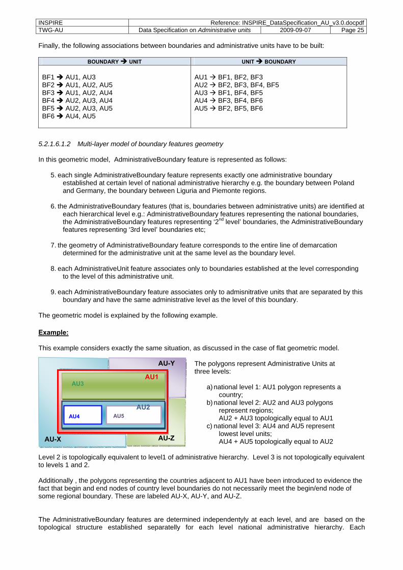
The geometric model is explained by the following example. Example: Assume the following situation for the area features (instances of AdministrativeUnit):
The polygons represent Administrative units at three levels:
a) national level 1: AU1 polygon represents a country;
b) national level 2: AU2 and AU3 polygons represent regions; AU2 + AU3 topologically equal to AU1
c) national level 3: AU4 and AU5 represent lowest level units;
AU4 + AU5 topologically equal to AU2 For AU3 there is no further subdivision.
Level 2 is topologically equivalent to level1 of administrative hierarchy. Level 3 is not topologically equivalent to levels 1 and 2. The boundary features (BF = instances of spatial object type AdministrativeBoundary) are built based on the topological structure of the entire (including all administrative levels) boundary geometry. Each BF consist of only one curve which is built between two connected nodes in the topological network. The nationalLevel attribute of the BF contains all relevant levels of the administrative hierarchy In this example the following vertices are identified:
The Points P3, P5, P7, and P8 are nodes in the topological structure, all other points are intermediate points (vertices).
Then, the curves and Boundary features are built as follows:
C1 = (P7, P1, P2, P3) = BF1
with nationalLevel=1, 2
C2 = (P3, P4, P5) = BF2
with nationalLevel=1, 2, 3
C3 = (P5, P6, P7) = BF3
with nationalLevel=1, 2, 3
C4 = (P7, P8) = BF4
with nationalLevel=2, 3
C5 = (P8, P3) = BF5
with nationalLevel=2, 3
C6 = (P8, P5) = BF6
with nationalLevel=3
AU1
AU2
AU3
AU5 AU4
AU1
AU2
AU3
AU5AU4
P1 P2
P5
P3
P4 P6
P7
P8
BF6
BF1
BF3 BF3
BF4 BF5
AU1
AU2
AU3
AU5AU4
P1 P2
P5
P3
P4 P6
P7 PP88
INSPIRE Reference: INSPIRE_DataSpecification_AU_v3.0.docpdfTWG-AU Data Specification on Administrative units 2009-09-07 Page 25
Finally, the following associations between boundaries and administrative units have to be built:
BOUNDARY UNIT UNIT BOUNDARY BF1 AU1, AU3 BF2 AU1, AU2, AU5 BF3 AU1, AU2, AU4 BF4 AU2, AU3, AU4 BF5 AU2, AU3, AU5 BF6 AU4, AU5
AU1 BF1, BF2, BF3 AU2 BF2, BF3, BF4, BF5 AU3 BF1, BF4, BF5 AU4 BF3, BF4, BF6 AU5 BF2, BF5, BF6
5.2.1.6.1.2 Multi-layer model of boundary features geometry In this geometric model, AdministrativeBoundary feature is represented as follows:
5. each single AdministrativeBoundary feature represents exactly one administrative boundary established at certain level of national administrative hierarchy e.g. the boundary between Poland and Germany, the boundary between Liguria and Piemonte regions.
6. the AdministrativeBoundary features (that is, boundaries between administrative units) are identified at each hierarchical level e.g.: AdministrativeBoundary features representing the national boundaries, the AdministrativeBoundary features representing ‘2nd level’ boundaries, the AdministrativeBoundary features representing ‘3rd level’ boundaries etc;
7. the geometry of AdministrativeBoundary feature corresponds to the entire line of demarcation determined for the administrative unit at the same level as the boundary level.
8. each AdministrativeUnit feature associates only to boundaries established at the level corresponding
to the level of this administrative unit.
9. each AdministrativeBoundary feature associates only to admisnitrative units that are separated by this boundary and have the same administrative level as the level of this boundary.
The geometric model is explained by the following example. Example: This example considers exactly the same situation, as discussed in the case of flat geometric model.
The polygons represent Administrative Units at three levels:
a) national level 1: AU1 polygon represents a country;
b) national level 2: AU2 and AU3 polygons represent regions; AU2 + AU3 topologically equal to AU1
c) national level 3: AU4 and AU5 represent lowest level units; AU4 + AU5 topologically equal to AU2
Level 2 is topologically equivalent to level1 of administrative hierarchy. Level 3 is not topologically equivalent to levels 1 and 2. Additionally , the polygons representing the countries adjacent to AU1 have been introduced to evidence the fact that begin and end nodes of country level boundaries do not necessarily meet the begin/end node of some regional boundary. These are labeled AU-X, AU-Y, and AU-Z. The AdministrativeBoundary features are determined independentyly at each level, and are based on the topological structure established separatelly for each level national administrative hierarchy. Each
AU-X
AU-Y
AU-Z
AU1
AU2
AU3
AU5 AU4
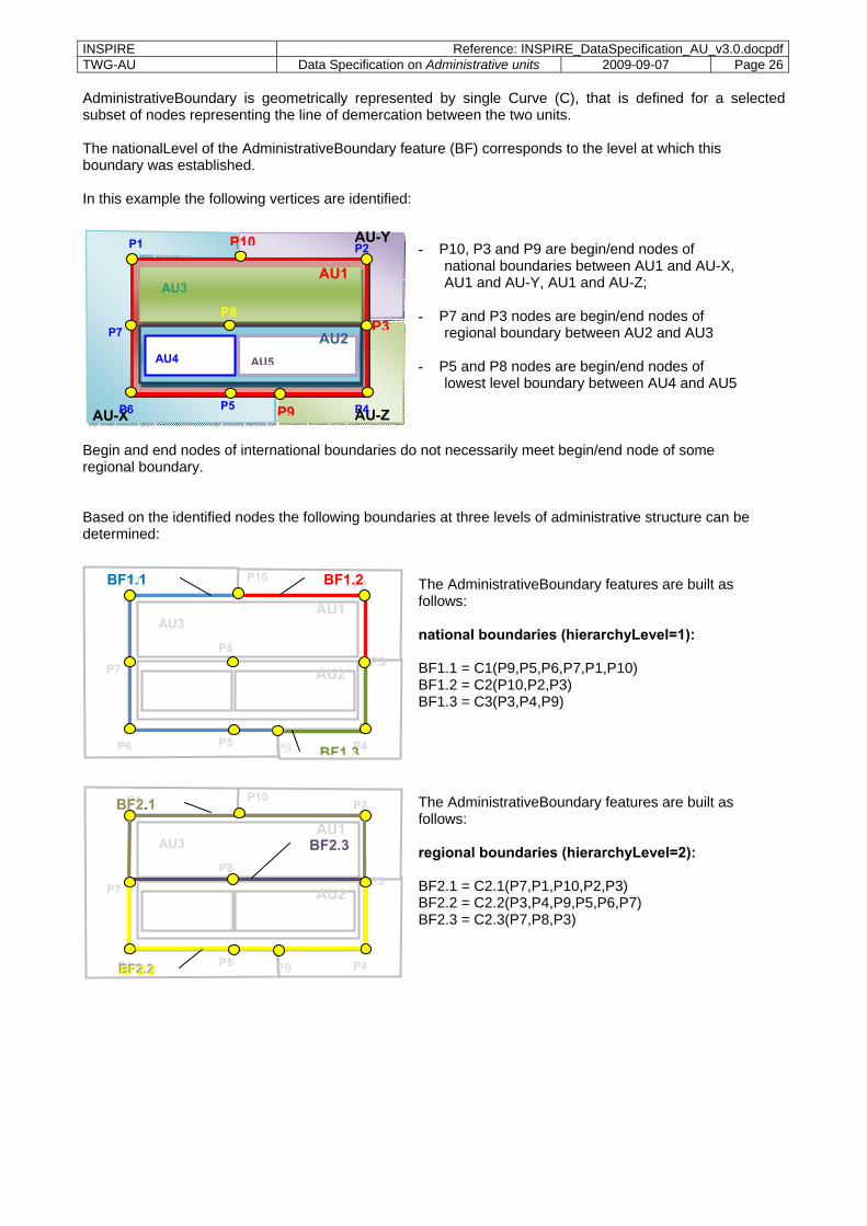
INSPIRE Reference: INSPIRE_DataSpecification_AU_v3.0.docpdfTWG-AU Data Specification on Administrative units 2009-09-07 Page 26
AdministrativeBoundary is geometrically represented by single Curve (C), that is defined for a selected subset of nodes representing the line of demercation between the two units. The nationalLevel of the AdministrativeBoundary feature (BF) corresponds to the level at which this boundary was established. In this example the following vertices are identified:
- P10, P3 and P9 are begin/end nodes of
national boundaries between AU1 and AU-X, AU1 and AU-Y, AU1 and AU-Z;
- P7 and P3 nodes are begin/end nodes of regional boundary between AU2 and AU3
- P5 and P8 nodes are begin/end nodes of lowest level boundary between AU4 and AU5
Begin and end nodes of international boundaries do not necessarily meet begin/end node of some regional boundary. Based on the identified nodes the following boundaries at three levels of administrative structure can be determined:
The AdministrativeBoundary features are built as follows: national boundaries (hierarchyLevel=1): BF1.1 = C1(P9,P5,P6,P7,P1,P10) BF1.2 = C2(P10,P2,P3) BF1.3 = C3(P3,P4,P9)
The AdministrativeBoundary features are built as follows: regional boundaries (hierarchyLevel=2): BF2.1 = C2.1(P7,P1,P10,P2,P3) BF2.2 = C2.2(P3,P4,P9,P5,P6,P7) BF2.3 = C2.3(P7,P8,P3)
AU1
AU2
AU3
AU5
P1 P2
P5 P4P6
P7
P8
P9
P10
P3
BF1 3
BF1.2 BF1.1
AU1
AU2
AU3
AU5
P1 P2
P5 P4P6
P7
P8
P9
P10
P3
BBBFFF222...222
BF2.1
BF2.3
AU-X
AU-Y
AU-Z
AU1
AU2
AU3
AU5AU4
P1 P2
P5
P3
P4P6
P7 PP88
P9
P10

INSPIRE Reference: INSPIRE_DataSpecification_AU_v3.0.docpdfTWG-AU Data Specification on Administrative units 2009-09-07 Page 27
The AdministrativeBoundary features are built as follows: local boundaries (hierarchyLevel=3): BF3.1 = C3.1=(P5,P6,P7,P8) BF3.2 = C3.2(P8,P5) BF3.3 = C3.3(P8,P3,P4,P9,P5)
Finally, the following associations between boundaries and administrative units have to be built:
BOUNDARY UNIT UNIT BOUNDARY national boundaries: BF1.1 AU1 (boundary with AU-X) BF1.2 AU1 (boundary with AU-Y) BF1.3 AU1 (boundary with AU-Z) regional boundaries: BF2.3 AU2, AU3 BF2.2 AU2 BF2.1 AU3 local boundaries: BF3.1 AU4 BF3.2 AU4, AU5 BF3.3 AU5
national units: AU1 BF1.1, BF1.2, BF1.3 regional units: AU2 BF2.1, BF2.2 AU3 BF2.1, BF2.3 local units: AU4 BF3.1, BF3.2 AU5 BF3.2, BF3.3
5.2.1.7 Temporality representation The application schema uses the attributes "beginLifespanObject" and "endLifespanObject" to record the lifespan of a spatial object. The attribute "beginLifespanVersion" specifies the date and time at which this version of the spatial object was inserted or changed in the spatial data set. The attribute "endLifespanVersion" specifies the date and time at which this version of the spatial object was superseded or retired in the spatial data set. NOTE 1 The attributes specify the beginning of the lifespan of the version in the spatial data set itself, which is different from the temporal characteristics of the real-world phenomenon described by the spatial object. This lifespan information, if available, supports mainly two requirements: First, knowledge about the spatial data set content at a specific time; second, knowledge about changes to a data set in a specific time frame. The lifespan information should be as detailed as in the data set (i.e., if the lifespan information in the data set includes seconds, the seconds should be represented in data published in INSPIRE) and include time zone information. NOTE 2 Changes to the attribute "endLifespanVersion" does not trigger a change in the attribute "beginLifespanVersion". Recommendation 7 If life-cycle information is not maintained as part of the spatial data set, all spatial
objects belonging to this data set should provide a void value with a reason of "unknown".
AU1
AU2
AU3
AU5
P1 P2
P5 P4P6
P7
P8
P9
P10
P3
BF3.1 BF3.3
BF3.2

INSPIRE Reference: INSPIRE_DataSpecification_AU_v3.0.docpdfTWG-AU Data Specification on Administrative units 2009-09-07 Page 28
5.2.2 Feature catalogue
5.2.2.1 Feature catalogue metadata
Table 3 – Feature catalogue metadata
Feature catalogue name INSPIRE feature catalogue AdministrativeUnits Scope AdministrativeUnits Version number 3.0 Version date 2009-08-31 Definition source INSPIRE data specification AdministrativeUnits
Table 4– Types defined in the feature catalogue
Type Package Stereotypes Section AdministrativeBoundary AdministrativeUnits «featureType» 5.2.2.2.1 AdministrativeHierarchyLevel AdministrativeUnits «codeList» 5.2.2.4.3 AdministrativeUnit AdministrativeUnits «featureType» 5.2.2.2.2 Condominium AdministrativeUnits «featureType» 5.2.2.2.3 LegalStatusValue AdministrativeUnits «enumeration» 5.2.2.4.1 ResidenceOfAuthority AdministrativeUnits «dataType» 5.2.2.3.1 TechnicalStatusValue AdministrativeUnits «enumeration» 5.2.2.4.2 NUTSRegion StatisticalUnits «featureType» 5.2.2.5.1
5.2.2.2 Spatial object types
5.2.2.2.1 AdministrativeBoundary AdministrativeBoundary Definition: A line of demarcation between administrative units. Status: Proposed Stereotypes: «featureType» Attribute: geometry Value type: GM_Curve Definition: Geometric representation of border line. Multiplicity: 1 Attribute: inspireId Value type: Identifier Definition: External object identifier of the administrative boundary. Description: NOTE An external object identifier is a unique object identifier published by the
responsible body, which may be used by external applications to reference the spatial object. The identifier is an identifier of the spatial object, not an identifier of the real-world phenomenon.
Multiplicity: 1 Attribute: country Value type: CountryCode Definition: Two-character country code according to ISO 3166. Multiplicity: 1 Attribute: nationalLevel Value type: AdministrativeHierarchyLevel Definition: The hierarchy levels of all adjacent administrative units this boundary is part of. Multiplicity: 1..6 Attribute: legalStatus Value type: LegalStatusValue Definition: Legal status of this administrative boundary.

INSPIRE Reference: INSPIRE_DataSpecification_AU_v3.0.docpdfTWG-AU Data Specification on Administrative units 2009-09-07 Page 29
AdministrativeBoundary Description: NOTE The legal status is considered in terms of political agreement or disagreement of
the administrative units separated by this boundary. Multiplicity: 1 Stereotypes: «voidable» Attribute: technicalStatus Value type: TechnicalStatusValue Definition: The technical status of the administrative boundary. Description: NOTE The technical status of the boundary is considered in terms of its topological
matching or not-matching with the borders of all separated administrative units. Edge-matched means that the same set of coordinates is used.
Multiplicity: 1 Stereotypes: «voidable» Attribute: beginLifespanVersion Value type: DateTime Definition: Date and time at which this version of the spatial object was inserted or changed in the
spatial data set. Multiplicity: 1 Stereotypes: «voidable,lifeCycleInfo» Attribute: endLifespanVersion Value type: DateTime Definition: Date and time at which this version of the spatial object was superseded or retired in
the spatial data set. Multiplicity: 0..1 Stereotypes: «voidable,lifeCycleInfo» Association role: admUnit Value type: AdministrativeUnit Definition: The administrative units separated by this administrative boundary. Description: NOTE In case of a national boundary (i.e. nationalLevel='1st order') only one national
administrative unit (i.e. country) is provided. Multiplicity: 1..* Stereotypes: «voidable»
5.2.2.2.2 AdministrativeUnit AdministrativeUnit Definition: Unit of administration where a Member State has and/or exercises jurisdictional rights,
for local, regional and national governance. Status: Proposed Stereotypes: «featureType» Attribute: geometry Value type: GM_MultiSurface Definition: Geometric representation of spatial area covered by this administrative unit. Multiplicity: 1 Attribute: nationalCode Value type: CharacterString Definition: Thematic identifier corresponding to the national administrative codes defined in each
country. Multiplicity: 1 Attribute: country Value type: CountryCode Definition: Two-character country code according to ISO 3166. Multiplicity: 1

INSPIRE Reference: INSPIRE_DataSpecification_AU_v3.0.docpdfTWG-AU Data Specification on Administrative units 2009-09-07 Page 30
AdministrativeUnit Attribute: name Value type: GeographicalName Definition: Official national geographical name of the administrative unit, given in several
languages where required. Multiplicity: 1..* Attribute: residenceOfAuthority Value type: ResidenceOfAuthority Definition: Center for national or local administration. Multiplicity: 1..* Stereotypes: «voidable» Attribute: beginLifespanVersion Value type: DateTime Definition: Date and time at which this version of the spatial object was inserted or changed in the
spatial data set. Multiplicity: 1 Stereotypes: «voidable,lifeCycleInfo» Attribute: endLifespanVersion Value type: DateTime Definition: Date and time at which this version of the spatial object was superseded or retired in
the spatial data set. Multiplicity: 0..1 Stereotypes: «voidable,lifeCycleInfo» Attribute: inspireId Value type: Identifier Definition: Eternal object identifier of the administrative unit. Description: NOTE An external object identifier is a unique object identifier published by the
responsible body, which may be used by external applications to reference the spatial object. The identifier is an identifier of the spatial object, not an identifier of the real-world phenomenon.
Multiplicity: 1 Attribute: nationalLevel Value type: AdministrativeHierarchyLevel Definition: Level in the national administrative hierarchy, at which the administrative unit is
established. Multiplicity: 1 Attribute: nationalLevelName Value type: LocalisedCharacterString Definition: Name of the level in the national administrative hierarchy, at which the administrative
unit is established. Multiplicity: 1..* Stereotypes: «voidable» Association role: condominium Value type: Condominium Definition: Condominium administered by this administrative unit Description: NOTE Condominiums may only exist at state level and can be administered only by
administrative units at the highest level of the national administrative hierarchy (i.e. countries).
Multiplicity: 0..* Stereotypes: «voidable» Association role: lowerLevelUnit Value type: AdministrativeUnit Definition: Units established at a lower level of the national administrative hierarchy which are
administered by this administrative unit.

INSPIRE Reference: INSPIRE_DataSpecification_AU_v3.0.docpdfTWG-AU Data Specification on Administrative units 2009-09-07 Page 31
Description: NOTE For administrative units at the lowest level of the national hierarchy no lower level unit exists. CONSTRAINT Each administrative unit except for the lowest level units shall refer to its lower level units
Multiplicity: 0..* Stereotypes: «voidable» Association role: upperLevelUnit Value type: AdministrativeUnit Definition: A unit established at a higher level of national administrative hierarchy that this
administrative unit administers. Description: NOTE Administrative units at the highest level of national hierarchy (i.e. the country) do
not have upper level units. CONSTRAINT Each administrative unit at the level other than '1st order' (i.e. nationalLevel <> '1st order') shall refer their upper level unit.
Multiplicity: 0..1 Stereotypes: «voidable» Association role: NUTS Value type: NUTSRegion Definition: NUTSRegion that topologically contains this administrative unit. NOTE NUTS regions
are Territorial units for statistics defined in the framework of the Regulation (EC) No 1059/2003 of the European Parliament and of the Council of 26 May 2003 (see hhtp:ec.europe.eu/eurostat/ramon/nuts/home_regions_de.html) NOTE2: Each administrative unit at lowest level is topologically covered by a certain NUTS3 region established for statistical purposes. Each NUTS3 region belongs to a specific NUTS2 region that is a part of NUTS1 region. The administrative unit at lowest level can refer the corresponding regions from all three levels: NUTS3, NUTS2, and NUTS1.
Multiplicity: 1..3 Stereotypes: «voidable» Association role: administeredBy Value type: AdministrativeUnit Definition: Administrative units established at same level of national administrative hierarchy
which are co-administered by this administrative unit. Multiplicity: 0..* Stereotypes: «voidable» Association role: coAdminister Value type: AdministrativeUnit Definition: A unit established at same level of national administrative hierarchy that administers
this administrative unit. Multiplicity: 0..* Stereotypes: «voidable» Association role: boundary Value type: AdministrativeBoundary Definition: The administrative boundaries between this administrative unit and all the units
adjacent to it. Description: NOTE Administrative boundary corresponds to the curve established between the
nodes at lowest level of territory division in Member State. Thus, it does not necessairly represents boundary in political terms, but just part of it.
Multiplicity: 1..* Stereotypes: «voidable» Constraint: AdmininstrativeUnitHighestLevel Natural
language: No unit at highest level can associate units at a higher level
OCL: inv: self.nationalLevel = '1stOrder' implies self.upperLevelUnit->isEmpty() and self.loweLevelUnit->notEmpty()

INSPIRE Reference: INSPIRE_DataSpecification_AU_v3.0.docpdfTWG-AU Data Specification on Administrative units 2009-09-07 Page 32
Constraint: AdministrativeUnitLowestLevel Natural
language: Units at the level '6thOrder' (i.e. nationalLevel = '6thOrder') in the administrative hierarchy cannot refer a unit at lower level.
OCL: inv: self.nationalLevel = '6thOrder' implies self.lowerLevelUnit->isEmpty Constraint: CondominiumsAtCountryLevel Natural
language: Association role condominium applies only for administrative units which nationalLevel='1st order' (country level).
OCL: inv: self.condominium->notEmpty implies self.nationalLevel = '1stOrder'
5.2.2.2.3 Condominium Condominium Definition: An administrative area established independently to any national administrative division
of territory and administered by two or more countries. Description: NOTE Condominium is not a part of any national administrative hierarchy of territory
division in Member State. Status: Proposed Stereotypes: «featureType» Attribute: inspireId Value type: Identifier Definition: External object identifier of the condominium. Description: NOTE An external object identifier is a unique object identifier published by the
responsible body, which may be used by external applications to reference the spatial object. The identifier is an identifier of the spatial object, not an identifier of the real-world phenomenon.
Multiplicity: 1 Attribute: name Value type: GeographicalName Definition: Official geographical name of this condominium, given in several languages where
required. Multiplicity: 0..* Stereotypes: «voidable» Attribute: geometry Value type: GM_MultiSurface Definition: Geometric representation of spatial area covered by this condominium Multiplicity: 1 Attribute: beginLifespanVersion Value type: DateTime Definition: Date and time at which this version of the spatial object was inserted or changed in the
spatial data set. Multiplicity: 1 Stereotypes: «voidable,lifeCycleInfo» Attribute: endLifespanVersion Value type: DateTime Definition: Date and time at which this version of the spatial object was superseded or retired in
the spatial data set. Multiplicity: 0..1 Stereotypes: «voidable,lifeCycleInfo» Association role: admUnit Value type: AdministrativeUnit Definition: The administrative unit administering the condominium Multiplicity: 1..* Stereotypes: «voidable»

INSPIRE Reference: INSPIRE_DataSpecification_AU_v3.0.docpdfTWG-AU Data Specification on Administrative units 2009-09-07 Page 33
5.2.2.3 Data types
5.2.2.3.1 ResidenceOfAuthority ResidenceOfAuthority Definition: Data type representing the name and position of a residence of authority. Status: Proposed Stereotypes: «dataType» Attribute: name Value type: GeographicalName Definition: Name of the residence of authority. Multiplicity: 1 Attribute: geometry Value type: GM_Point Definition: Position of the residence of authority. Multiplicity: 1 Stereotypes: «voidable»
5.2.2.4 Enumerations and code lists
5.2.2.4.1 LegalStatusValue LegalStatusValue Definition: Description of the legal status of administrative boundaries. Status: Proposed Stereotypes: «enumeration» Value: agreed Definition: The edge-matched boundary has been agreed between neighbouring administrative
units and is stable now. Value: notAgreed Definition: The edge-matched boundary has not yet been agreed between neighbouring
administrative units and could be changed.
5.2.2.4.2 TechnicalStatusValue TechnicalStatusValue Definition: Description of the technical status of administrative boundaries. Status: Proposed Stereotypes: «enumeration» Value: edgeMatched Definition: The boundaries of neighbouring administrative units have the same set of coordinates. Value: notEdgeMatched Definition: The boundaries of neighbouring administrative units do not have the same set of
coordinates.
5.2.2.4.3 AdministrativeHierarchyLevel AdministrativeHierarchyLevel Definition: Levels of administration in the national administrative hierarchy. Status: Proposed Stereotypes: «codeList» Governance: Centrally managed in INSPIRE code list register. URN: urn:x-
inspire:def:codeList:INSPIRE:AdministrativeHierarchyLevel Value: 1stOrder Definition: Highest level in the national administrative hierarchy (country level). Value: 2ndOrder Definition: 2nd level in the national administrative hierarchy. Value: 3rdOrder Definition: 3rd level in the national administrative hierarchy.

INSPIRE Reference: INSPIRE_DataSpecification_AU_v3.0.docpdfTWG-AU Data Specification on Administrative units 2009-09-07 Page 34
AdministrativeHierarchyLevel Value: 4thOrder Definition: 4th level in the national administrative hierarchy. Value: 5thOrder Definition: 5th level in the national administrative hierarchy. Value: 6thOrder Definition: 6th level in the national administrative hierarchy.
5.2.2.5 Candidate types and placeholders
5.2.2.5.1 NUTSRegion NUTSRegion Package: StatisticalUnits [Candidate type that might be extended in Annex II/III INSPIRE data
specification] Definition: Territorial unit for statistics defined in the framework of the Regulation (EC) No
1059/2003 of the European Parliament and of the Council of 26 May 2003. Description: NOTE NUTS regions subdivide each Member State into a whole number of territorial
units for statistic at NUTS1 level. Each of these is then subdivided into regions at NUTS2 level and these in turn into regions at NUTS3 level.
Status: Proposed Stereotypes: «featureType» Attribute: geometry Value type: GM_MultiSurface Definition: Geometric representation of spatial area covered by this NUTS-region. Multiplicity: 1 Attribute: inspireId Value type: Identifier Definition: External object identifier of the NUTSRegion. Description: NOTE An external object identifier is a unique object identifier published by the
responsible body, which may be used by external applications to reference the spatial object. The identifier is an identifier of the spatial object, not an identifier of the real-world phenomenon.
Multiplicity: 1 Attribute: NUTSCode Value type: CharacterString Definition: Unique code of the territorial unit for statistics as defined in the framework of the
Regulation (EC) No 1059/2003 of the European Parliament and of the Council of 26 May 2003.
Description: EXAMPLE A NUTScode from Denmark could be DK031. Multiplicity: 1 Attribute: beginLifespanVersion Value type: DateTime Definition: Date and time at which this version of the spatial object was inserted or changed in the
spatial data set. Multiplicity: 1 Stereotypes: «voidable,lifeCycleInfo» Attribute: endLifespanVersion Value type: DateTime Definition: Date and time at which this version of the spatial object was superseded or retired in
the spatial data set. Multiplicity: 0..1 Stereotypes: «voidable,lifeCycleInfo»

INSPIRE Reference: INSPIRE_DataSpecification_AU_v3.0.docpdfTWG-AU Data Specification on Administrative units 2009-09-07 Page 35
5.2.2.6 Imported types (informative) This section lists definitions for feature types, data types and enumerations and code lists that are defined in other application schemas. The section is purely informative and should help the reader understand the feature catalogue presented in the previous sections. For the normative documentation of these types, see the given references.
5.2.2.6.1 NamedPlace NamedPlace Package: Geographical Names [see DS-D2.8.I.3] Definition: Any real world entity referred to by one or several proper nouns.
5.2.2.6.2 GeographicalName GeographicalName Package: Geographical Names [see DS-D2.8.I.3] Definition: Proper noun applied to a real world entity.
5.2.2.6.3 Identifier Identifier Package: Base Types [DS-D2.5] Definition: Unique object identifier published by the responsible body, which may be used by
external applications to reference the spatial object. Description: NOTE1 External object identifiers are distinct from thematic object identifiers.
NOTE 2 The voidable version identifier attribute is not part of the unique identifier of a spatial object and may be used to distinguish two versions of the same spatial object. NOTE 3 The unique identifier will not change during the life-time of a spatial object.
6 Reference systems
6.1 Coordinate reference systems
6.1.1 Datum
Requirement 12 For the coordinate reference systems used for making available the INSPIRE spatial data sets, the datum shall be the datum of the European Terrestrial Reference System 1989 (ETRS89) in areas within its geographical scope, and the datum of the International Terrestrial Reference System (ITRS) or other geodetic coordinate reference systems compliant with ITRS in areas that are outside the geographical scope of ETRS89. Compliant with the ITRS means that the system definition is based on the definition of the ITRS and there is a well established and described relationship between both systems, according to EN ISO 19111.

INSPIRE Reference: INSPIRE_DataSpecification_AU_v3.0.docpdfTWG-AU Data Specification on Administrative units 2009-09-07 Page 36
6.1.2 Coordinate reference systems
Requirement 13 INSPIRE spatial data sets shall be made available using one of the three-dimensional, two-dimensional or compound coordinate reference systems specified in the list below.
Other coordinate reference systems than those listed below may only be used for
regions outside of continental Europe. The geodetic codes and parameters for these coordinate reference systems shall be documented, and an identifier shall be created, according to EN ISO 19111 and ISO 19127.
1. Three-dimensional Coordinate Reference Systems
– Three-dimensional Cartesian coordinates – Three-dimensional geodetic coordinates (latitude, longitude and ellipsoidal height), using the
parameters of the GRS80 ellipsoid 2. Two-dimensional Coordinate Reference Systems
– Two-dimensional geodetic coordinates, using the parameters of the GRS80 ellipsoid – Plane coordinates using the Lambert Azimuthal Equal Area projection and the parameters of the
GRS80 ellipsoid – Plane coordinates using the Lambert Conformal Conic projection and the parameters of the GRS80
ellipsoid – Plane coordinates using the Transverse Mercator projection and the parameters of the GRS80
ellipsoid 3. Compound Coordinate Reference Systems
– For the horizontal component of the compound coordinate reference system, one of the two-dimensional coordinate reference systems specified above shall be used
– For the vertical component on land, the European Vertical Reference System (EVRS) shall be used to express gravity-related heights within its geographical scope
6.1.3 Display
Requirement 14 For the display of the INSPIRE spatial data sets with the View Service specified in D003152/02 Draft Commission Regulation implementing Directive 2007/2/EC of the European Parliament and of the Council as regards Network Services, at least the coordinates reference systems for two-dimensional geodetic shall be available
6.1.4 Identifiers for coordinate reference systems
Requirement 15 For referring to the non-compound coordinate reference systems listed in this Section, the identifiers listed below shall be used.
For referring to a compound coordinate reference system, an identifier composed of the
identifier of the horizontal component, followed by a slash (/), followed by the identifier of the vertical component, shall be used.
- ETRS89-XYZ for Cartesian coordinates in ETRS89 - ETRS89-GRS80h for three-dimensional geodetic coordinates in ETRS89 on the GRS80 ellipsoid - ETRS89-GRS80 for two-dimensional geodetic coordinates in ETRS89 on the GRS80 - EVRS for height in EVRS - LAT for depth of the sea floor, where there is an appreciable tidal range - MSL for depth of the sea floor, in marine areas without an appreciable tidal range, in open oceans and
effectively in waters that are deeper than 200m - ISA for pressure coordinate in the free atmosphere - PFO for Pressure coordinate in the free ocean

INSPIRE Reference: INSPIRE_DataSpecification_AU_v3.0.docpdfTWG-AU Data Specification on Administrative units 2009-09-07 Page 37
- ETRS89-LAEA for ETRS89 coordinates projected into plane coordinates by the Lambert Azimuthal Equal Area projection
- ETRS89-LCC for ETRS89 coordinates projected into plane coordinates by the Lambert Conformal Conic projection
- ETRS89-TMzn for ETRS89 coordinates projected into plane coordinates by the Transverse Mercator projection
6.2 Temporal reference system
Requirement 16 The Gregorian Calendar shall be used for as a reference system for date values, and the Universal Time Coordinated (UTC) or the local time including the time zone as an offset from UTC shall be used as a reference system for time values.
7 Data quality This section includes a description of data quality elements and sub-elements as well as the associated data quality measures to be used to describe data related to the spatial data theme Administrative units (see Table 5) NOTE Additional guidance documents on procedures and methods that can be used to implement the basic data quality measures introduced in this section will be provided at a later stage. In addition, recommendations on minimum data quality are included for specific elements. Data quality information can be described at level of spatial object (feature), spatial object type (feature type), dataset or dataset series. Data quality information at spatial object level is modelled directly in the application schema (Chapter 5). Recommendation 8 Aggregated data quality information should ideally be collected at the level of spatial
object types and included in the dataset (series) metadata. Chapter 8 describes the corresponding metadata elements to report about this data quality information.
Table 5– List of all data quality elements used in the spatial data theme Administrative units
Section Data quality element
Data quality sub-element
Scope(s)
7.1.1 Completeness Commission dataset 7.1.2 Completeness Omission dataset
7.2.1 Logical consistency Topological consistency
dataset
7.2.2 Logical consistency Conceptual consistency
dataset
7.2.3 Positional accuracy Absolute external positional accuracy
dataset
7.1 Completeness
7.1.1 Commission Commission should be documented using the rate of excess items. Name Rate of excess items Alternative name –

INSPIRE Reference: INSPIRE_DataSpecification_AU_v3.0.docpdfTWG-AU Data Specification on Administrative units 2009-09-07 Page 38
Data quality element Completness Data quality sub-element Commission Data quality basic measure 1) Counting-related data quality basic measures:
Error rate Definition Number of excess items in the dataset in relation to the number
of items that should have been present. Description – Parameter – Data quality value type Real, percentage, ratio (example: 0,0189 ; 98,11% ; 11:582) Data quality value structure – Source reference – Example – Measure identifier 3 (ISO 19138)
7.1.2 Omission Omission should be documented using the rate of missing items. Name Rate of missing items Alternative name – Data quality element Completeness Data quality sub-element Omission Data quality basic measure 1) Counting-related data quality basic measures:
Error rate Definition Number of missing items in the dataset in relation to the number
of items that should have been present. Description – Parameter – Data quality value type Real, percentage, ratio (example: 0,0189 ; 98,11% ; 11:582) Data quality value structure – Source reference – Example – Measure identifier 7 (ISO 19138)
7.2 Logical consistency
7.2.1 Topological consistency
7.2.1.1 Number of faulty point-curve connections
Name number of faulty point-curve connections Alternative name extraneous nodes Data quality element DQ_LogicalConsistency Data quality subelement DQ_TopologicalConsistency Data quality basic measure Error count Definition number of faulty point-curve connections in the dataset Description A point-curve connection exists where different curves touch. These
curves have an intrinsic topological relationship that has to reflect the true constellation. If the point-curve connection contradicts the universe of discourse, the point-curve connection is faulty with respect to this data quality measure. The data quality measure counts the number of errors of this kind.
Parameter - Data quality value type Integer Data quality value structure - Source reference - Example - Measure identifier 9

INSPIRE Reference: INSPIRE_DataSpecification_AU_v3.0.docpdfTWG-AU Data Specification on Administrative units 2009-09-07 Page 39
7.2.1.2 Number of missing connection due to undershoots
Name number of missing connection due to undershoots Alternative name Undershoots Data quality element DQ_LogicalConsistency Data quality subelement DQ_TopologicalConsistency Data quality basic measure error count Definition count of items in the dataset, within the parameter tolerance, that are
mismatched due to undershoots Description - Parameter search distance from the end of a dangling line Data quality value type Integer Data quality value structure - Source reference - Example - Measure identifier 23
7.2.2 Conceptual consistency
7.2.2.1 Conceptual Schema compliance Name Conceptual Schema compliance Alternative name - Data quality element DQ_LogicalConsistency Data quality subelement DQ_ConceptualConsistency Data quality basic measure Correctness indicator Definition indication that an item complies with the rules of the relevant
conceptual schema Description - Parameter - Data quality value type True Data quality value structure - Source reference - Measure identifier 9
7.3 Positional accuracy
7.3.1 Absolute external positional accuracy
7.3.1.1 Mean value of positional uncertainties (1D, 2D) Name mean value of positional uncertainties (1D, 2D and 3D) Alternative name - Data quality element DQ_PositionalAccuracy Data quality subelement DQ_AbsoluteExternalPositionalAccuracy Data quality basic measure not applicable Definition Mean value of the positional uncertainties for a set of positions where
the positional uncertainties are defined as the distance between a measured position and what is considered as the corresponding true position
Description See ISO 19138 Parameter - Data quality value type Measure Data quality value structure - Source reference - Example - Measure identifier 28

INSPIRE Reference: INSPIRE_DataSpecification_AU_v3.0.docpdfTWG-AU Data Specification on Administrative units 2009-09-07 Page 40
8 Dataset-level Metadata Metadata can be reported for each individual spatial object (spatial object-level metadata) or once for a complete dataset or dataset series (dataset-level metadata). Spatial object-level metadata is fully described in the application schema (section 5). If data quality elements are used at spatial object level, the documentation shall refer to the appropriate definition in section 7. This section only specifies dataset-level metadata elements. For some dataset-level metadata elements, in particular on data quality and maintenance, a more specific scope can be specified. This allows the definition of metadata at sub-dataset level, e.g. separately for each spatial object type. When using ISO 19115/19139 to encode the metadata, the following rules should be followed:
− The scope element (of type DQ_Scope) of the DQ_DataQuality subtype should be used to encode the scope.
− Only the following values should be used for the level element of DQ_Scope: Series, Dataset, featureType.
− If the level is featureType the levelDescription/MDScopeDescription/features element (of type Set< GF_FeatureType>) shall be used to list the feature type names.
NOTE The value featureType is used to denote spatial object type. Mandatory or conditional metadata elements are specified in Section 8.1. Optional metadata elements are specified in Section 8.2. The tables describing the metadata elements contain the following information:
− The first column provides a reference to a more detailed description. − The second column specifies the name of the metadata element. − The third column specifies the multiplicity. − The fourth column specifies the condition, under which the given element becomes mandatory (only
for Table 6 and Table 7).
8.1 Mandatory and conditional metadata elements
Requirement 17 The metadata describing a spatial data set or a spatial data set series related to the theme Administrative units shall comprise the metadata elements required by Regulation 1205/2008/EC (implementing Directive 2007/2/EC of the European Parliament and of the Council as regards metadata) for spatial datasets and spatial dataset series (Table 6) as well as the metadata elements specified in Table 7.
Table 6– Metadata for spatial datasets and spatial dataset series specified in Regulation 1205/2008/EC (implementing Directive 2007/2/EC of the European Parliament and of the Council as
regards metadata)
Metadata Regulation Section
Metadata element Multiplicity Condition
1.1 Resource title 1
1.2 Resource abstract 1
1.3 Resource type 1
1.4 Resource locator 0..* Mandatory if a URL is available to obtain more information on the resource, and/or access related services.
1.5 Unique resource identifier 1..*

INSPIRE Reference: INSPIRE_DataSpecification_AU_v3.0.docpdfTWG-AU Data Specification on Administrative units 2009-09-07 Page 41
1.7 Resource language 0..* Mandatory if the resource includes textual information.
2.1 Topic category 1..*
3 Keyword 1..*
4.1 Geographic bounding box 1..*
5 Temporal reference 1..*
6.1 Lineage 1
6.2 Spatial resolution 0..* Mandatory for data sets and data set series if an equivalent scale or a resolution distance can be specified.
7 Conformity 1..*
8.1 Conditions for access and use
1..*
8.2 Limitations on public access
1..*
9 Responsible organisation 1..*
10.1 Metadata point of contact 1..*
10.2 Metadata date 1
10.3 Metadata language 1
Table 7– Mandatory and conditional theme-specific metadata for the theme Administrative units
INSPIRE Data Specification Administrative units Section
Metadata element Multiplicity Condition
8.1.1 Coordinate Reference System
1
8.1.2 Temporal Reference System
0..* Mandatory, if the spatial data set or one of its feature types contains temporal information that does not refer to the Gregorian Calendar or the Coordinated Universal Time.
8.1.3 Encoding 1..*
8.1.4 Character Encoding 0..* Mandatory, if a non-XML-based encoding is used that does not support UTF-8

INSPIRE Reference: INSPIRE_DataSpecification_AU_v3.0.docpdfTWG-AU Data Specification on Administrative units 2009-09-07 Page 42
8.1.1 Coordinate Reference System Metadata element name Coordinate Reference System
Definition Description of the coordinate reference system used in the dataset.
ISO 19115 number and name 13. referenceSystemInfo ISO/TS 19139 path referenceSystemInfo INSPIRE obligation / condition mandatory INSPIRE multiplicity 1 Data type(and ISO 19115 no.) 189. MD_CRS
Domain Either the referenceSystemIdentifier (RS_Identifier) or the projection (RS_Identifier), ellipsoid (RS_Identifier) and datum (RS_Identifier) properties shall be provided.
Implementing instructions -
Example referenceSystemIdentifier: code: ETRS_89 codeSpace: INSPIRE RS registry
Example XML encoding - Comments -
8.1.2 Temporal Reference System Metadata element name Temporal Reference System
Definition Description of the temporal reference systems used in the dataset.
ISO 19115 number and name 13. referenceSystemInfo ISO/TS 19139 path referenceSystemInfo
INSPIRE obligation / condition Mandatory, if the spatial data set or one of its feature types contains temporal information that does not refer to the Gregorian Calendar or the Coordinated Universal Time.
INSPIRE multiplicity 0..* Data type(and ISO 19115 no.) 186. MD_ReferenceSystem
Domain
No specific type is defined in ISO 19115 for temporal reference systems. Thus, the generic MD_ReferenceSystem element and its reference SystemIdentifier (RS_Identifier) property shall be provided.
Implementing instructions -
Example referenceSystemIdentifier: code: GregorianCalendar codeSpace: INSPIRE RS registry
Example XML encoding - Comments -
8.1.3 Encoding
Metadata element name Encoding
Definition Description of the computer language construct that specifies the representation of data objects in a record, file, message, storage device or transmission channel
ISO 19115 number and name 271. distributionFormat ISO/TS 19139 path distributionInfo/MD_Distribution/distributionFormat INSPIRE obligation / condition mandatory INSPIRE multiplicity 1..* Data type (and ISO 19115 no.) 284. MD_Format

INSPIRE Reference: INSPIRE_DataSpecification_AU_v3.0.docpdfTWG-AU Data Specification on Administrative units 2009-09-07 Page 43
Domain
See B.2.10.4. The following property values shall be used for default and alternative encodings specified in section 8.1.3 Default Encoding − name: Administrative units GML application schema − version: version 3.0; GML, version 3.2.1 − specification: D2.8.I.4 Data Specification on Administrative
units – Draft Guidelines� Implementing instructions -
Example
name: Administrative units GML application schema version: version 3.0, GML, version 3.2.1 specification: D2.8.I.4 Data Specification on Administrative units – Guidelines
Example XML encoding - Comments -
8.1.4 Character Encoding
Metadata element name Metadata dataset character set
Definition Full name of the character coding standard used for the dataset.
ISO 19115 number and name 4. characterSet ISO/TS 19139 path IdentificationInfo/*/characterSet
INSPIRE obligation / condition Mandatory, if a non-XML-based encoding is used that does not support UTF-8
INSPIRE multiplicity 0..* Data type(and ISO 19115 no.) 40. MD_CharacterSetCode Domain Codelist (See B.5.10 of ISO 19115) Implementing instructions Example Example XML encoding Comments
8.2 Optional metadata elements Recommendation 9 The metadata describing a spatial data set or a spatial data set series related to the
theme Administrative units should comprise the theme-specific metadata elements specified in Table 8.
Table 8 - Optional theme-specific metadata for the theme Administrative units
Section Metadata element Multiplicity 8.2.1 Maintenance Information 0..1
8.2.2 Data Quality – Completeness – Commission 0..*
8.2.3 Data Quality – Completeness – Omission 0..*
8.2.4 Data Quality - Logical consistency – Topological Consistency 0..*
8.2.5 Data Quality - Positional accuracy – Absolute or external accuracy 0..*
8.2.1 Maintenance Information
Metadata element name Maintenance information Definition information about the scope and frequency of updating ISO 19115 number and name 30. resourceMaintenance ISO/TS 19139 path identificationInfo/MD_Identification/resourceMaintenance

INSPIRE Reference: INSPIRE_DataSpecification_AU_v3.0.docpdfTWG-AU Data Specification on Administrative units 2009-09-07 Page 44
INSPIRE obligation / condition optional INSPIRE multiplicity 0..1 Data type (and ISO 19115 no.) 142. MD_MaintenanceInformation
Domain
This is a complex type. The following elements should be used: − maintenanceAndUpdateFrequency / definition: frequency
with which changes and additions are made to the resource after the initial resource is completed / domain value: MD_MaintenanceFrequencyCode:
- updateScope / definition: scope of data to which maintenance is applied / domain value: MD_ScopeCode
- maintenanceNote / definition: information regarding specific requirements for maintaining the resource / domain value: free text
Implementing instructions - Example Example XML encoding Comments -
8.2.2 Data Quality – Completeness - Commission
Metadata element name Data Quality – Completeness - Commission
Definition
DQ Completeness: presence and absence of features, their attributes and their relationships; Commission: excess data present in the dataset, as described by the scope
ISO 19115 number and name 18. dataQualityInfo ISO/TS 19139 path dataQualityInfo INSPIRE obligation / condition optional INSPIRE multiplicity 0..* Data type (and ISO 19115 no.) 109. DQ_CompletenessCommission Domain Lines 100-107 from ISO 19115 Implementing instructions Example Example XML encoding Comments See clause 7.1.1 in Chapter 7 for detailed information.
8.2.3 Data Quality – Completeness - Omission
Metadata element name Data Quality – Completeness - Ommission Definition data absent from the dataset, as described by the scope ISO 19115 number and name 18. dataQualityInfo ISO/TS 19139 path dataQualityInfo INSPIRE obligation / condition optional INSPIRE multiplicity 0..* Data type (and ISO 19115 no.) 110. DQ_CompletenessOmission Domain Lines 100-107 from ISO 19115 Implementing instructions Example Example XML encoding Comments See clause 7.1.2 in Chapter 7 for detailed information.
8.2.4 Data Quality – Logical Consistency – Topological Consistency
Metadata element name Data Quality – Logical Consistency – Topological Consistency
Definition correctness of the explicitly encoded topological characteristics of the dataset as described by the scope
ISO 19115 number and name 18. dataQualityInfo

INSPIRE Reference: INSPIRE_DataSpecification_AU_v3.0.docpdfTWG-AU Data Specification on Administrative units 2009-09-07 Page 45
ISO/TS 19139 path dataQualityInfo INSPIRE obligation / condition optional INSPIRE multiplicity 0..* Data type (and ISO 19115 no.) 115. DQ_TopologicalConsistency Domain Lines 100-107 from ISO 19115 Implementing instructions Example Example XML encoding Comments See clause 7.2.1in Chapter 7 for detailed information.
8.2.5 Data Quality – Positional Accuracy – Absolute or external accuracy
Metadata element name Data Quality - Positional accuracy - Absolute or external accuracy
Definition closeness of reported coordinate values to values accepted as or being true
ISO 19115 number and name 18. dataQualityInfo ISO/TS 19139 path dataQualityInfo INSPIRE obligation / condition optional INSPIRE multiplicity 0..* Data type (and ISO 19115 no.) 117. DQ_AbsoluteExternalPositionalAccuracy Domain Lines 100-107 from ISO 19115 Implementing instructions Example Example XML encoding Comments See clause 7.3.1 in Chapter 7 for detailed information.
8.3 Guidelines on using metadata elements defined in Regulation 1205/2008/EC
8.3.1 Conformity The Conformity metadata element defined in Regulation 1205/2008/EC allows to report the conformance with the Implementing Rule for interoperability of spatial data sets and services or another specification. The degree of conformity of the dataset can be Conformant (if the dataset is fully conformant with the cited specification), Not Conformant (if the dataset does not conform to the cited specification) or Not evaluated (if the conformance has not been evaluated). Recommendation 10 The Conformity metadata element should be used to report conceptual consistency
with this INSPIRE data specification. The value of Conformant should be used for the Degree element only if the dataset passes all the requirements described in the abstract test suite presented in Annex A. The Specification element should be given as follows:
- title: “INSPIRE Data Specification on Administrative units –Guidelines” - date: 07 September 2009 - dateType: publication - date: 2009-09-07
8.3.2 Lineage Following the ISO 19113 Quality principles, if a data provider has a procedure for quality validation of their spatial data sets then the data quality elements listed in the Chapter 8 should be used. If not, the Lineage metadata element (defined in Regulation 1205/2008/EC) should be used to describe the overall quality of a spatial data set. According to Regulation 1205/2008/EC, lineage “is a statement on process history and/or overall quality of the spatial data set. Where appropriate it may include a statement whether the data set has been validated or quality assured, whether it is the official version (if multiple versions exist), and whether it has legal validity. The value domain of this metadata element is free text”.

INSPIRE Reference: INSPIRE_DataSpecification_AU_v3.0.docpdfTWG-AU Data Specification on Administrative units 2009-09-07 Page 46
Recommendation 11 Apart from describing the process history, if feasible within a free text, the overall quality of the dataset (series) should be included in the Lineage metadata element. This statement should contain any quality information required for interoperability and/or valuable for use and evaluation of the data set (series).
8.3.3 Temporal reference According to Regulation 1205/2008/EC, at least one of the following temporal reference metadata elements shall be provided: temporal extent, date of publication, date of last revision, date of creation. If feasible, the date of the last revision of a spatial data set should be reported
9 Delivery
9.1 Delivery medium
Requirement 18 Data conformant to this INSPIRE data specification shall be made available through an INSPIRE network service.
Requirement 19 All information that is required by a calling application to be able to retrieve the data through the used network service shall be made available in accordance with the requirements defined in the Implementing Rules on Network Services.
EXAMPLE 1 Through the Get Spatial Objects function, a download service can either download a pre-defined data set or pre-defined part of a data set (non-direct access download service), or give direct access to the spatial objects contained in the data set, and download selections of spatial objects based upon a query (direct access download service). To execute such a request, some of the following information might be required:
− the list of spatial object types and/or predefined data sets that are offered by the download service (to be provided through the Get Download Service Metadata operation),
− and the query capabilities section advertising the types of predicates that may be used to form a query expression (to be provided through the Get Download Service Metadata operation, where applicable),
− a description of spatial object types offered by a download service instance (to be provided through the Describe Spatial Object Types operation).
EXAMPLE 2 Through the Transform function, a transformation service carries out data content transformations from native data forms to the INSPIRE-compliant form and vice versa. If this operation is directly called by an application to transform source data (e.g. obtained through a download service) that is not yet conformant with this data specification, the following parameters are required: Input data (mandatory). The data set to be transformed.
− Source model (mandatory, if cannot be determined from the input data). The model in which the input data is provided.
− Target model (mandatory). The model in which the results are expected. − Model mapping (mandatory, unless a default exists). Detailed description of how the transformation is
to be carried out.

INSPIRE Reference: INSPIRE_DataSpecification_AU_v3.0.docpdfTWG-AU Data Specification on Administrative units 2009-09-07 Page 47
9.2 Encodings Requirement 20 Data conformant to the application schema Administrative units shall be encoded using
the encoding specified in section 9.2.1.1.
Format name: Administrative units 3.0 GML Application Schema Version of the format: Administrative units 3.0, GML, version 3.2.1 Reference to the specification of the format: ISO 19136:2007 Character set: UTF-8 The GML Application Schema is distributed in a zip-file separately from the data specification document.
10 Data Capture No data capture rules specified, except that national administrative data of best available quality according to this specification should be provided after it has been edge matched at international boundaries between responsible organizations of neighbouring countries. It could be useful to consider the experiences (results) from EuroGeographics concerning the edge matching of international boundaries, which has been done by BKG together with the EBM project partners of 39 European National Mapping and Cadastral Agencies for creation of the seamless EuroBoundaryMap reference geo database.
11 Portrayal This clause defines the default rules for layers and styles to be used for portrayal of the spatial object types defined for this theme. In section 11.1 the types of layers are defined that are to be used for the portrayal of the spatial object types defined in this specification. A view service may offer several layers of the same type, one for each dataset that it offers on a specific topic. Section 11.2 specifies the default styles to be used for each of these layer types, while section 11.3 specifies other well-defined styles. The XML fragments in these sections use the following namespace prefixes: • sld="http://www.opengis.net/sld" (WMS/SLD 1.1) • se="http://www.opengis.net/se" (SE 1.1) • ogc="http://www.opengis.net/ogc" (FE 1.1)
11.1 Layer types
Requirement 21 If an INSPIRE view service supports the portrayal of data related to the theme Administrative units, it shall provide the layers specified in this section.
Table 9: Layer types for the spatial data theme Administrative units
Layer Name Layer Title Spatial object type(s) Keywords AU.AdministrativeUnit Administrative unit AdministrativeUnit AU.AdministrativeBoundary Administrative boundary AdministrativeBoundary AU.Condominium Condominium Condominium AU.NUTSRegion NUTS Region NUTSRegion

INSPIRE Reference: INSPIRE_DataSpecification_AU_v3.0.docpdfTWG-AU Data Specification on Administrative units 2009-09-07 Page 48
11.2 Default Styles Requirement 22 If an INSPIRE view network service supports the portrayal of spatial data sets
corresponding to the spatial data theme Administrative units, it shall support the default styles specified in the tables in this section.
If no user-defined style is specified in a portrayal request for a specific layer to an
INSPIRE view service, the default style specified in this section for that layer shall be used.
Table 10: Default styles for the spatial data theme Administrative units
Layer Name AU.AdministrativeUnit Style Name AU.AdministrativeUnit.Default Style Title Administrative Unit Default Style
Style Description
The administrative unit is rendered using a yellow f(#FFFF66) fill.
Symbology <sld:NamedLayer> <se:Name>AU.AdministrativeUnit</se:Name> <sld:UserStyle> <se:Name> AU.AdministrativeUnit.Default</se:Name> <sld:IsDefault>1</sld:IsDefault> <se:FeatureTypeStyle version="1.1.0"> <se:Description> <se:Title>Administrative Unit Default Style </se:Title> <se:Abstract>The administrative unit is rendered using a yellow (#FFFF66) fill. .</se:Abstract> </se:Description> <se:FeatureTypeName>AdministrativeUnit</se:FeatureTypeName> <se:Rule> <se:PolygonSymbolizer> <se:Geometry> <ogc:PropertyName>geometry</ogc:PropertyName> </se:Geometry> <se:Fill> <se:SvgParameter name="fill">#FFFF66</se:SvgParameter> </se:Fill> <se:Stroke/> </se:PolygonSymbolizer> </se:Rule> </se:FeatureTypeStyle> </sld:UserStyle> </sld:NamedLayer>

INSPIRE Reference: INSPIRE_DataSpecification_AU_v3.0.docpdfTWG-AU Data Specification on Administrative units 2009-09-07 Page 49
Layer Name AU.AdministrativeBoundary Style Name AU.AdministrativeBoundary.Default Style Title Administrative Boundary Default Style
Style Description
Administrative boundaries are rendered using a red (#FF0033) line.
Symbology <sld:NamedLayer> <se:Name>AU.AdministrativeBoundary</se:Name> <sld:UserStyle> <se:Name> AU.AdministrativeBoundary.Default </se:Name> <sld:IsDefault>1</sld:IsDefault> <se:FeatureTypeStyle version="1.1.0"> <se:Description> <se:Title> Administrative Boundary Default Style </se:Title> <se:Abstract> The administrative boundary is rendered using a red (#FF0033) line. .</se:Abstract> </se:Description> <se:FeatureTypeName>AdministrativeUnit</se:FeatureTypeName> <se:Rule> <se:LineSymbolizer> <se:Geometry> <ogc:PropertyName>geometry</ogc:PropertyName> </se:Geometry> <se:Stroke> <se:SvgParameter name="stroke">#FF0033</se:SvgParameter> <se:SvgParameter name="stroke-width">4</se:SvgParameter> </se:Stroke> </se:LineSymbolizer> </se:Rule> </se:FeatureTypeStyle> </sld:UserStyle> </sld:NamedLayer>
Layer Name AU.Condominium Style Name AU.Condominium.Default Style Title Condominium Default Style
Style Description
Condominiums are rendered using a violet (#FF99FF) fill.

INSPIRE Reference: INSPIRE_DataSpecification_AU_v3.0.docpdfTWG-AU Data Specification on Administrative units 2009-09-07 Page 50
Symbology <sld:NamedLayer> <se:Name>AU.Condominium</se:Name> <sld:UserStyle> <se:Name> AU.Condominium.Default</se:Name> <sld:IsDefault>1</sld:IsDefault> <se:FeatureTypeStyle version="1.1.0"> <se:Description> <se:Title> Condominium Default Style</se:Title> <se:Abstract>Condominiums are rendered using a violet (#FF99FF) fill. </se:Abstract> </se:Description> <se:FeatureTypeName>Condominium</se:FeatureTypeName> <se:Rule> <se:PolygonSymbolizer> <se:Geometry> <ogc:PropertyName>geometry</ogc:PropertyName> </se:Geometry> <se:Fill> <se:SvgParameter name="fill">#FF99FF</se:SvgParameter> </se:Fill> <se:Stroke/> </se:PolygonSymbolizer> </se:Rule> </se:FeatureTypeStyle> </sld:UserStyle> </sld:NamedLayer>
Layer Name AU.NUTSRegion Style Name AU.NUTSRegion.Default Title NUTSRegion default style
Style Description
NUTSRegions are rendered using a gray (#E5E5E5) fill.
Symbology <sld:NamedLayer> <se:Name> AU.NUTSRegion </se:Name> <sld:UserStyle> <se:Name> AU.NUTSRegion.Default</se:Name> <sld:IsDefault>1</sld:IsDefault> <se:FeatureTypeStyle version="1.1.0"> <se:Description> <se:Title>NUTSRegion Default Style</se:Title> <se:Abstract>NUTSRegions are rendered using a gray (#E5E5E5) fill. </se:Abstract> </se:Description> <se:FeatureTypeName>NUTSRegion</se:FeatureTypeName> <se:Rule> <se:PolygonSymbolizer> <se:Geometry> <ogc:PropertyName>geometry</ogc:PropertyName> </se:Geometry> <se:Fill> <se:SvgParameter name="fill">#E5E5E5</se:SvgParameter> </se:Fill> <se:Stroke/> </se:PolygonSymbolizer> </se:Rule> </se:FeatureTypeStyle> </sld:UserStyle> </sld:NamedLayer>
Minimum & maximum scales
No scale limits
11.3 Other Well-defined Styles There are no other well-defined styles for the spatial data theme Administrative units.

INSPIRE Reference: INSPIRE_DataSpecification_AU_v3.0.docpdfTWG-AU Data Specification on Administrative units 2009-09-07 Page 51
11.4 Layers organization No special layer organization defined.
Bibliography EUROSTAT, European Commision 2005, GIS reference data: update of reference layers Provision of European geographic databases and related services for administrative and statistical regions and for topography. Call for tenders for the supply of GIS related services 2005/S 143-142116 EEA 2006, European Enviroment Agency, Guide to geographical data and maps, january 2006 version 2.0. URL : http://www.eionet.europa.eu/gis/docs/EEA_GISguide_v2.doc [DS-D2.5] INSPIRE Generic Conceptual Model, v3.1. [DS-D2.6] INSPIRE Methodology for the development of data specifications, v3.0. [DS-D2.7] INSPIRE Guidelines for the encoding of spatial data, v3.0. [DS-D2.8.I.3] INSPIRE DS-D2.8.I.3, INSPIRE data specification on Geographical names – Guidelines, v3.0 INSPIRE IMS, 2003, Implementation Strategy Issues - Data Requirements by: INSPIRE Implementation Strategy Group, subgroup data requirements, Editor: Arvid Lillethun, 28 April 2003. INSPIRE RDM, 2002, INSPIRE position paper: Reference Data. October 2002 URL: http://www.ec-gis.org/inspire/reports/position_papers/inspire_rdm_pp_v4_3_en.pdf

INSPIRE Reference: INSPIRE_DataSpecification_AU_v3.0.docpdfTWG-AU Data Specification on Administrative units 2009-09-07 Page 52
Annex A (normative)
Abstract Test Suite
Any dataset conforming to this INSPIRE data specification shall meet all requirements specified in this document. NOTE A common abstract test suite including detailed instructions on how to test each requirement will be added at a later stage.

INSPIRE Reference: INSPIRE_DataSpecification_AU_v3.0.docpdf TWG-AU Data Specification on Administrative units 2009-09-07 Page 53
Annex B (informative) Correspondence between national administrative levels and NUTS-levels (2007)
country-level 2nd order 3rd order 4th order 5th order 6th order
BE ÉtatFédéral Région (NUTS1) 3 Province
(NUTS2) 10 Arrondissement (NUTS3) 43
Commune, Gemeente (LAU2)
589
BG Държава Област (NUTS3) 28 Община
(LAU1) 264 Землище (~ LAU2) 4623
CZ Stát (NUTS1) Kraj (NUTS3) 14 Okres (LAU1) 76 Obec (LAU2) 6249
DK Kongeriget (NUTS1)
Sysler (NUTS2) 6 Kommuner
(LAU1) 99
DE Bundesrepublik Bundesland (NUTS1) 16 Regierungsbezirk
(~ NUTS2) 22 Landkreis, Stadtkreis (NUTS3) 437
Verwaltungs- gemeinschaft (LAU1)
1471Gemeinde, Stadt (~LAU2)
12458
EE Vabariik (NUTS1, NUTS2)
Maakond (LAU1) 15 Linn, Vald
(LAU2) 226
IE Republic (NUTS1)
Euregion (NUTS2) 2 Regional
Authority (NUTS3) 8 County (LAU1) 34 Electoral
Division (LAU2) 3441
GR Ελληνική Δημοκρατία
Περιφέρεια (NUTS2) 13 Νομός
(~ NUTS3) 55 Δήμος/Κοινότητα (LAU1) 1034
ES Reino Comunidad Autónoma (NUTS2)
17 Provincia (~ NUTS3) 50
Término Municipal, Ciudad Autónoma ( +Condominio) (~ LAU2)
8108 (+84)
FR République Région (NUTS2) 26 Département
(NUTS3) 100 Arrondissement 342 Canton de rattachement (~ LAU1)
3806 Commune (+Zone d’eau) (~ LAU2)
36702 (+2)
IT Repubblica Regione (NUTS2) 20 Provincia
(NUTS3) 107 Comune (LAU2) 8101
CY Δημοκρατία (NUTS1, NUTS2, NUTS3)
Επαρχία (LAU1) 6 Δήμος/Κοινότητα
(LAU2) 611
LV Republika (NUTS1, NUTS2)
Republikas pilsēta, Rajons (LAU1)
33 Pagasts, Pilsētas lauku teritorija, Novads, Rajona pilsēta (LAU2)
523
LT Respublika Apskritis 10 Rajono 62 Seniūnija, Seniūnija 516

INSPIRE Reference: INSPIRE_DataSpecification_AU_v3.0.docpdf TWG-AU Data Specification on Administrative units 2009-09-07 Page 54
(NUTS1, NUTS2) (NUTS3) savivaldybė, Miesto savivaldybė, Savivaldybė (LAU1)
(m.sav.) (LAU2)
LU Grand-Duché (NUTS1,NUTS2, NUTS3)
Canton (LAU1) 12 Commune
(LAU2) 116
HU Ország Régió (NUTS2) 7 Megye
(NUTS3) 20 Kistérség (LAU1) 168 Település
(~ LAU2) 3167
MT Repubblika (NUTS1, NUTS2)
Kunsilli Locali (LAU2) 68
NL Land Provincie (NUTS2) 12 Gemeente
(~ LAU2) 458
AT Republik Bundesland (NUTS2) 9 Bezirkshaupt-
mannschaft 98 Gemeinde (LAU2) 2358
PL Państwo Województwo (NUTS2) 16 Powiat
(LAU1) 379 Gmina (LAU2) 2478
PT República Continente, Região Autónoma (NUTS1)
3 Distrito, Ilha 29 Concelho (LAU1) 308 Freguesia
(LAU2) 4260
RO Ţara Minicipiul Bucureşti, Judeţ (NUTS3)
42 Sector, Municipiu, Oraş, Comună (~ LAU2)
3160
SI Država (NUTS1) Občina (LAU2) 210 Naselje 6005
SK Republika (NUTS1) Kraj (NUTS3) 8 Okres
(LAU1) 79 Obec (LAU2) 2928
FI Tasavalta,Republik Lääni, Län 6
Maakunta, Landskap (NUTS3)
20 Kunta, Kommun (~ LAU2) 431
SE Kungarike Län (NUTS3) 21 Kommun (LAU2) 290 -
UK: United Kingdom Great Britain 1 Country 3 Metropolitan District, County, Unitary Authority, London Borough
264 District, Council 239
Electoral Division,Ward (~ LAU2)
10658
Correspondence between national administrative levels from country level to 6th order level and NUTS/LAU-levels (2007), number of units of administrative levels has been derived from data/metadata delivered by National Mapping and Cadastral Agencies for EuroGeographics EuroBoundaryMap v2.0 product (2007), table has been established by EBM- manager and approved by Eurostat in August 2008

INSPIRE Reference: INSPIRE_ DataSpecification_AU_v3.0.pdfTWG-AU Data Specification on Administrative units 2009-09-07 Page 55
Annex C (informative) National Administrative Hierarchies (examples from Germany and Norway)
Germany (DE) Level of admini-stration
Unique structure identifier
Designation of the hierarchy level given in national characters
Designation of the hierarchy level transli-terated in ASCII characters
English translation or equivalent of the designation
Signi-ficant digits of the SHN code
Number of objects
USE ISN DESN DESA 1st order (country) 1301 Bundesrepublik Bundesrepublik Country 2 1
1302 Bundesland Bundesland County 4 14 2nd order 1307 Bundesland Bundesland County 4 2
3rd order 1308 Regierungsbezirk Regierungsbezirk Government region 5 22
1311 Landkreis Landkreis District 8 323 4th order 1312 Stadtkreis Stadtkreis District 8 114
5th order 1313 Verwaltungs-gemeinschaft
Verwaltungs-gemeinschaft
Municipal association 10 1471
1314 Gemeinde Gemeinde Municipality 13 1785 1315 Stadt Stadt City 13 1248
1316 Verbandsange-hörige Gemeinde
Verbandsange-hoerige Gemeinde
Municipality belonging to an association
13 8470
1317 Verbandsange-hörige Stadt
Verbandsange-hoerige Stadt
City belonging to an association 13 708
6th order
1321 Gemeindefreies Gebiet
Gemeindefreies Gebiet
Non-municipal area 13 248
USE1 USE2 USE3 USE4 USE5 USE6
SHN D E

INSPIRE Reference: INSPIRE_DataSpecification_AU_v3.0.docpdf TWG-AU Data Specification on Administrative units 2009-09-07 Page 56
1st order (country)
2nd order
3rd order
4th order
5th order
6th order
(Taken from German lineage file for EBM v2.0)
1301 Bundesrepublik
1307 Bundesland
1302 Bundesland
1308 Regierungs-bezirk
1312 Stadtkreis
1311 Landkreis
1313 Verwaltungs-gemeinschaft
1317 Verbandsang.
Stadt
1316 Verbandsang.
Gemeinde
1315 Stadt
1314 Gemeinde
1321 Gemeindefreies
Gebiet
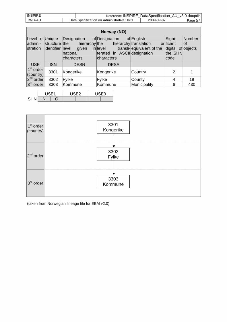
INSPIRE Reference INSPIRE_DataSpecification_AU_v3.0.docpdf: TWG-AU Data Specification on Administrative Units 2009-09-07 Page 57
Norway (NO) Level of admini-stration
Unique structure identifier
Designation of the hierarchy level given in national characters
Designation of the hierarchy level transli-terated in ASCII characters
English translation or equivalent of the designation
Signi-ficant digits of the SHN code
Number of objects
USE ISN DESN DESA 1st order (country) 3301 Kongerike Kongerike Country 2 1
2nd order 3302 Fylke Fylke County 4 19 3rd order 3303 Kommune Kommune Municipality 6 430
USE1 USE2 USE3 SHN N O
1st order (country)
2nd order
3rd order
(taken from Norwegian lineage file for EBM v2.0)
3301 Kongerike
3302 Fylke
3303 Kommune
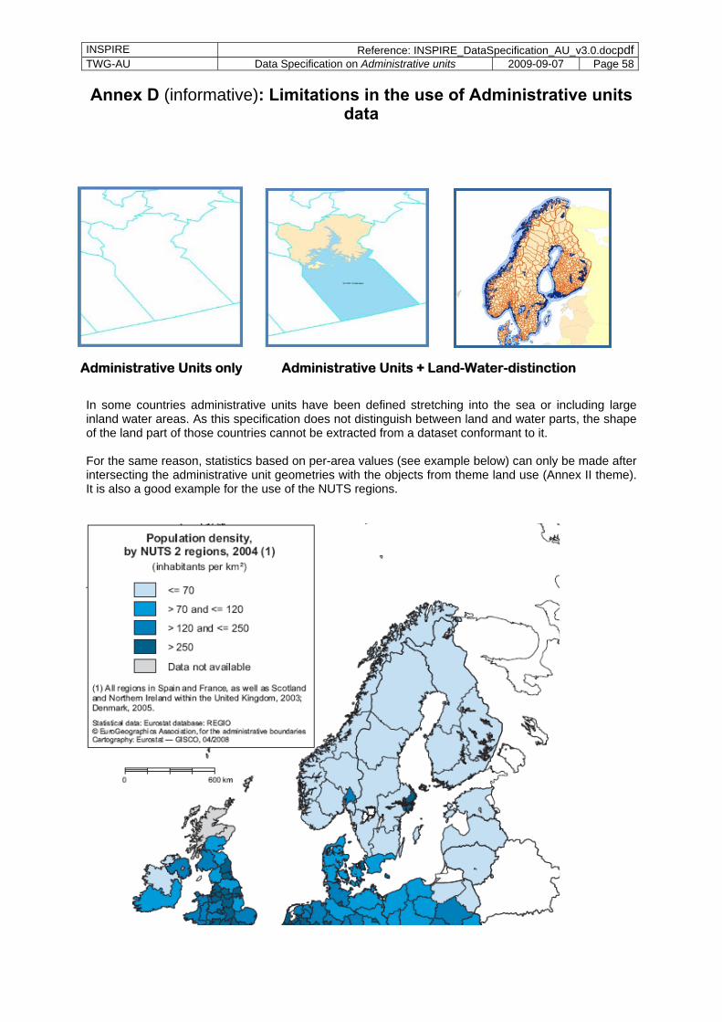
INSPIRE Reference: INSPIRE_DataSpecification_AU_v3.0.docpdfTWG-AU Data Specification on Administrative units 2009-09-07 Page 58
Annex D (informative): Limitations in the use of Administrative units data
In some countries administrative units have been defined stretching into the sea or including large inland water areas. As this specification does not distinguish between land and water parts, the shape of the land part of those countries cannot be extracted from a dataset conformant to it. For the same reason, statistics based on per-area values (see example below) can only be made after intersecting the administrative unit geometries with the objects from theme land use (Annex II theme). It is also a good example for the use of the NUTS regions.
Administrative Units only Administrative Units + Land-Water-distinction