integrated geoprocessing for generation of affected assets and rights reports for high voltage...
TRANSCRIPT

Integrated Geoprocessing for Generation of Affected Assets and Rights Reports for
High Voltage Electrical Infrastructures
F. Vladimir GutiérrezJanuary 31 - 2012
Federico-Vladimir Gutiérrez-Corea, Miguel-Ángel Manso-Callejo, Francisco-Javier Moreno-Marimbaldo, Emerson Castaneda-Sanabria
AGENDA
1. INTRODUCTION1.1. MOTIVATING SCENARIO 1.2. BACKGROUND / Departure point1.3. THE CHALLENGES
2. PROCESSES AND INFORMATION CHARACTERISATION
3. SOLUTION APROACH3.1. WORKFLOW AUTOMATION3.2. SYSTEM ARCHITECTURE AND DESIGN
4. RESULTS
5. CONCLUSION AND FUTURE WORKS

INTRODUCTION
New linear constructions (streets/roads, railways, gas pipeline, electrical installations) … implies calculation of the effects over plots :
INTRODUCTION
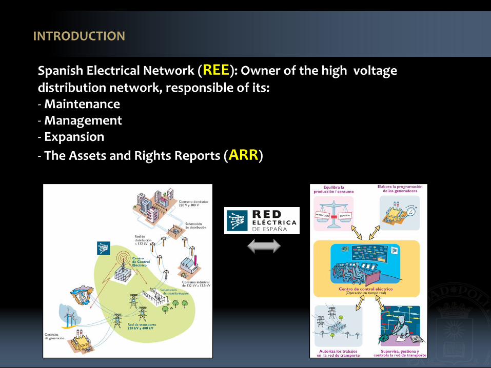
Spanish Electrical Network (REE): Owner of the high voltage distribution network, responsible of its:- Maintenance- Management- Expansion- The Assets and Rights Reports (ARR)
INTRODUCTION
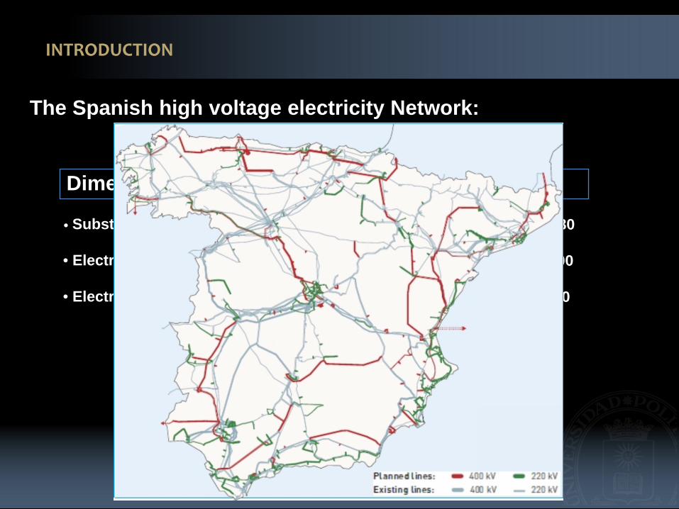
Dimensions up to 2012
• Substations : 470
• Electrical circuits (km): 36 500
• Electricity pylons: 75 000
Planning 2020
The Spanish high voltage electricity Network:
• Substations : 680
• Electrical circuits (km): 54 000
• Electricity pylons: 112 500

MOTIVATION SCENARIO
Increment 45 %
48 %
50%
• Substations
• Electrical circuits (km)
• Electricity Towers:
BACKGROUND / Departure point
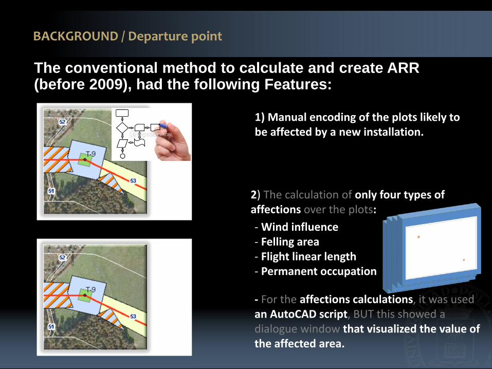
The conventional method to calculate and create ARR(before 2009), had the following Features:
1) Manual encoding of the plots likely to be affected by a new installation.
2) The calculation of only four types of affections over the plots: - Wind influence- Felling area- Flight linear length- Permanent occupation
- For the affections calculations, it was used an AutoCAD script, BUT this showed a dialogue window that visualized the value of the affected area.

BACKGROUND
3) Generation of the ARR.
This calculation method was useful for REE until 2009.
Why?- An electrical line of 50 Km. - Four types of affections. - 250 the average amount of plots.:Approximately 200 hours.
THE CHALLENGES
(1) The need of producing more ARR in less time
(2) Reduce the excessive duration of the process (200 hours in average)
(3) Reduce the high cost of data preparation
(4) To Manage broad kind of affections (up to 15).
These critical points required the design of a new working methodology and the creation of new software for supporting GeoProcessing optimization and generation of ARR.
PROCESSES AND INFORMATION CHARACTERISATION
The processes and data needed are related within:
(1) Affected properties on the territory
(2) Cadastral information
(3) One or more areas of direct affections on the plots by the new construction elements
(4) One or more indirect affections on the plots by pathways which allow access for constructions and maintenance

PROCESSES AND INFORMATION CHARACTERISATION
PROCESSES AND INFORMATION CHARACTERISATION
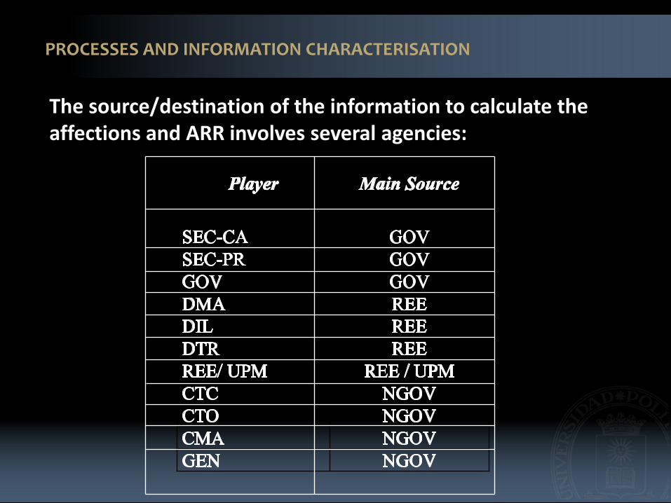
The source/destination of the information to calculate theaffections and ARR involves several agencies:

PROCESSES AND INFORMATION CHARACTERISATION

1 42 3
SOLUTION APROACH

1
WORKFLOW AUTOMATION

WORKFLOW AUTOMATION
7 GIS layers are the inputs of this process, one for plots and the other six forencoding.
The plots likely to be affected are selected.
The encoding for each plot is assigned taking into account the direction of advancement of the electrical wire and access.
The linear reference systems is used for reach the previous requirements.

WORKFLOW AUTOMATION
7 GIS layers are the inputs of this process, one for plots and the other six forencoding.
The plots likely to be affected are selected.
The encoding number for each plot is assigned taking into account the direction of advancement of the trace and access.
The linear reference systems is used for reach the previous requirements.
2
WORKFLOW AUTOMATION

WORKFLOW AUTOMATION
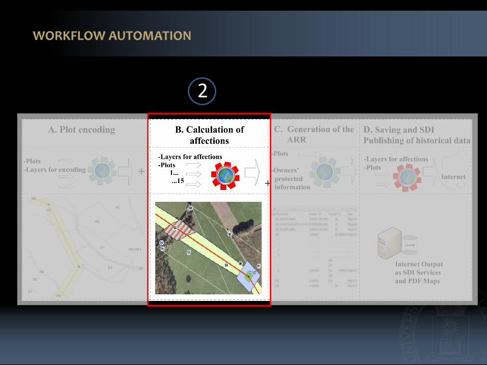
16 GIS layers are the inputs of this process, one for plots and the other 15 are the affections layers .
This process carries out integrated GeoProcessing on plots geometries as a function of the affections.
Aggregation by attributes, intersections and clipping among others are part of operations executed for supporting this process.
the areas and perimeters are calculated for each type of affection over each plot
3
WORKFLOW AUTOMATION

WORKFLOW AUTOMATION
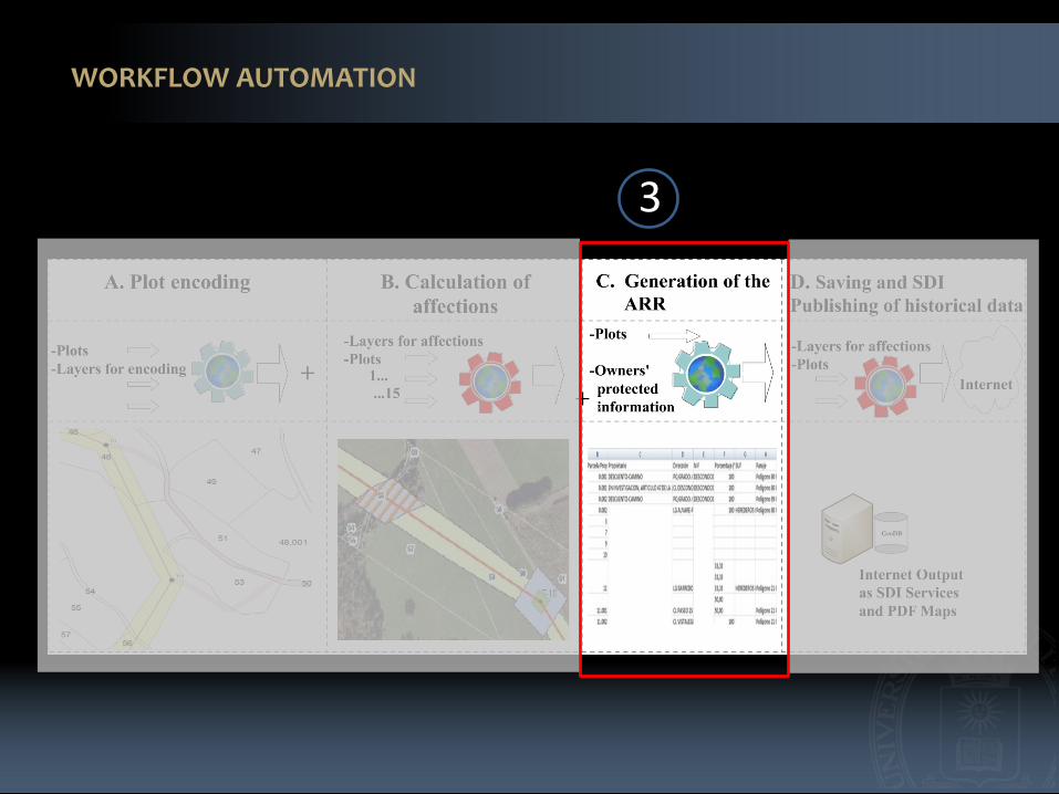
There are two inputs for this process. Oneis the plots layer and the other is an XMLfile with the protected information of the affected plot owners.
The process combines the two data sources and generates an ARR output as a spreadsheet.
This spreadsheet is the initial document to be reviewed before being submitted to the Administrations for its publication.
4
WORKFLOW AUTOMATION

WORKFLOW AUTOMATION
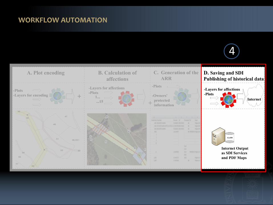
The inputs for this process are the plots with all its affection values as well as the geometric details of each affection.
All the data are converted to the interchange Geography Markup Language (GML) format.
The GMLs are submitted through transactional operations to the server which implements the WFS-T
The information can be queried in a standard fashion by using the WMS and WFS services.
Internet
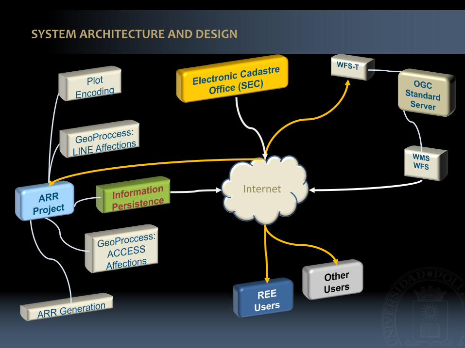
SYSTEM ARCHITECTURE AND DESIGN

SYSTEM ARCHITECTURE AND DESIGN

RESULTS
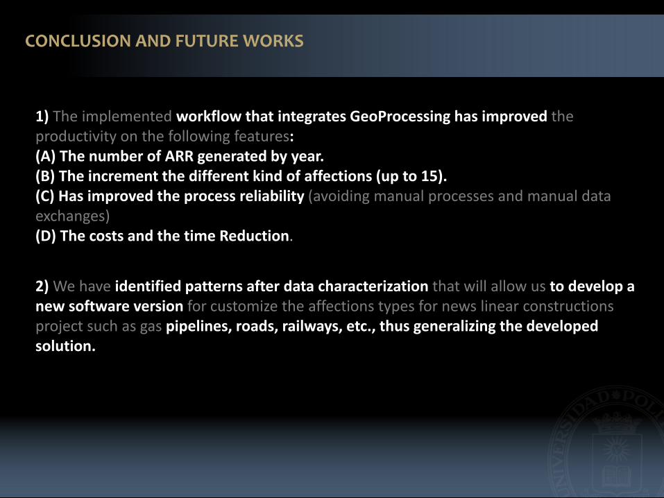
1) The implemented workflow that integrates GeoProcessing has improved the productivity on the following features: (A) The number of ARR generated by year. (B) The increment the different kind of affections (up to 15).(C) Has improved the process reliability (avoiding manual processes and manual data exchanges) (D) The costs and the time Reduction.
CONCLUSION AND FUTURE WORKS
2) We have identified patterns after data characterization that will allow us to develop a new software version for customize the affections types for news linear constructions project such as gas pipelines, roads, railways, etc., thus generalizing the developed solution.
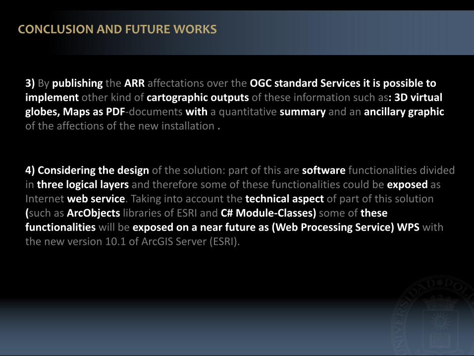
3) By publishing the ARR affectations over the OGC standard Services it is possible to implement other kind of cartographic outputs of these information such as: 3D virtual globes, Maps as PDF-documents with a quantitative summary and an ancillary graphic of the affections of the new installation .
CONCLUSION AND FUTURE WORKS
4) Considering the design of the solution: part of this are software functionalities divided in three logical layers and therefore some of these functionalities could be exposed as Internet web service. Taking into account the technical aspect of part of this solution (such as ArcObjects libraries of ESRI and C# Module-Classes) some of these functionalities will be exposed on a near future as (Web Processing Service) WPS with the new version 10.1 of ArcGIS Server (ESRI).