integrated water monitoring system applied …pesd.ro/articole/nr.5/2/05. das.pdf · integrated...
TRANSCRIPT
PRESENT ENVIRONMENT AND SUSTAINABLE DEVELOPMENT, VOL. 5, no.2, 2011
INTEGRATED WATER MONITORING SYSTEM APPLIED BY
SIRET RIVER BASIN ADMINISTRATION FROM ROMANIA,
IMPORTANT MECHANISM FOR THE PROTECTION
OF WATER RESOURCES
Dan Dăscăliţa1
Keywords: water integrated monitoring, body of water, good water status.
Abstract. The current status of Romania as European Community membership
gives, in addition to a number of rights, many obligations concerning especially the
implementation and compliance with relevant EU regulations. In the water sector
The European Commission considered necessary the development of a new,
common, uniform and consistent policy, which takes into account all the aspects
linked both to human needs as well as to the existence of ecosystems and to
sustainable development of water resources. Back in 2000, after a long decisional
process, the European Community approved the Water Framework Directive
(Directive 2000/60/EC), which established a policy framework for water
management in the European Union based on sustainable development principles
and which integrated all water issues, including problems of water’s integrated
monitoring. In Romania the water’s monitoring system has been working since the
early twentieth century, but since 1976 when the Water Directorate at basinal level
were established this system has been developing into a scientific and defining
structure. Water monitoring network has continuously suffered additions and
improvements, but since 2002 the question of the modernization and the
development of water integrated monitoring system was raised so it could meet
European standards and the monitoring requirements and it could run in a dynamic,
complex process and with spiral development. In this paper we presented some
aspects concerning the synthesis of integrated water monitoring system, important
mechanism for water resources management, applied to the Siret Basin by Siret
River Basin Administration (ABAS).
Introduction Water Integrated Monitoring System aims coherent and comprehensive
assessment of the status of water bodies and its evolution over time so that
programs of measures and their effectiveness can be established, and it involves the
crossing of distinct phases:
1 Senior researcher PhD., Siret River Basin Administration, Bacău, [email protected]
Dan Dăscăliţa 46
- establishing monitoring subsystems;
- establishing the investigating media;
- determining the spatial structure;
- identification of monitoring types;
- establishing the quality elements to be monitored;
- establishing the monitoring frequencies;
- establishing the hierarchy of laboratories.
In Romania, Water Integrated Monitoring System has been operating in a scientific and definite structure since 1976, when the Basin Water Directorates
were established. The water monitoring system had been working since the early
twentieth century, but at a much lower level, through an insufficient monitoring network and without an integrated quantity - quality approach, and with a greater
emphasis on hydrometric measurements at few stations located especially on the
major rivers of the first order. Water monitoring network has continuously suffered additions and
improvements, but since 2002 the question of the modernization and the
development of water integrated monitoring system was raised so it could meet the
European standards and the monitoring requirements and it could run in a dynamic,
complex process and with spiral development.
The aims of this study are: evaluating the quality of the water resources in
the area of activity of Siret River Basin Administration in Romania, in accordance
with the Framework Directive 60/2000/CE and monitoring programs within the
National Monitoring System Integrated Management in Romania (SMIAR). The Framework Directive 60/2000/CE is transposed in different laws in Romania
based on the normative definitions of employment quality status. For the evaluation
of the water quality specific parameters have been analysed, for which maximum limits have been set for each quality state separately.
1. Materials and methods
1.1. Types, subsystems and specific programs of water integrated mon. In
accordance with the Water Framework Directive 60/2000/CE fully transposed into
Romanian legislation, the National Monitoring System Integrated Management
(SMIAR) includes three types of monitoring:
- Surveillance Monitoring;
- Operational Monitoring; - Investigation Monitoring.
Surveillance monitoring serves in the assessment of water status within each
river basin or sub basin. It provides information for the validation of the impact
assessment procedure, for the efficient design of the future monitoring programs
and for the assessment of long-term trend of variation of water resources.
Integrated water monitoring system applied by Siret river basin administration 47
Operational monitoring should be conducted for all water bodies, which upon
the impact according to Annex II of the Framework Directive, or upon the basis of
surveillance monitoring, were identified as not likely to carry out the
environmental objectives. It seeks to define the status of aquatic ecosystems at risk
or which present risk of failing to meet environmental objectives. This type of
monitoring should be conducted for all water bodies in which priority substances
are discharged.
Investigation Monitoring is carried out to certificate the causes due to which a water body fails to achieve environmental objectives and to identify the causes of
exceeding of limits of quality standards.
Monitoring system provided by the Water Framework Directive and the other European Directives approaches three areas of investigation, namely water,
sediment / suspended solids and biota and includes six subsystems: River
Subsystem, Lakes Subsystem, Transitional Waters Subsystem, Coastal Waters Subsystem, Groundwater Subsystem, Wastewater Subsystem.
Achieving integrated water monitoring system is currently done through
specific monitoring programs, namely:
- surveillance monitoring program (S), applied to surface water and
groundwater;
- operational monitoring program (O), applied to surface water and
groundwater;
- investigation monitoring program (I) applied to surface water;
- sections of reference program (R) applied to surface water; - intercalibration program for ecological status (IC), applied to surface water;
- drinking water program (P), applied to surface water and groundwater;
- vulnerable areas program (ZV), applied to surface water and groundwater; - ichthyofauna monitoring program (IH) applied to surface water;
- habitats and Species Protection Program (HS), applied to surface water;
- international conventions program (CI), applied to surface water and
groundwater;
- the knowledge of morphological alterations pressures program (CAPM),
applied to surface waters;
- "the best available section” program (CBSD) applied to surface streams.
1.2. Evaluation of the quality of water resources. The evaluation of surface
water and groundwater status is achieved in accordance with the Framework Directive 60/2000/CE, transposed in different laws in Romania based on the
normative definitions of employment quality status and based on specific
parameters for which maximum limits have been set for each quality state
separately, as it follows:

Dan Dăscăliţa 48
a. For grading and classification of surface water bodies in ecological
states conditions, five regulatory environmental status were defined (very good,
good, moderate, weak, poor) in tab. 1.
Tab. 1 - General definitions of ecological status of surface waters
Very good status Good status Moderate status Poor status Bad status
•There are slight
anthropogenic alterations of the values of physico-
chemical and hydro-
morphological quality
elements for the type of
surface water bodies,
compared with normally
associated values with that
type in no change
conditions.
•The values of biological
quality elements for the
type of surface water body
reflect the values normally
associated with that type, in
unchanged conditions. The
indicated deflections are
zero or there are few evidences of disturbance.
•Conditions are specific to the type and the
communities.
Values for
biological quality
elements for such a surface water
body present low
levels of modifications due
to human
activities and
deviate slightly
from those values
associated
normally with the
body type of
surface water in
unchanged
conditions.
Values for
biological quality
elements for such a surface water
body deviates
moderately from those associated
with the body
type of surface
water in
unchanged
conditions.
Values present
moderate signs of
disturbance due to
human activities
and are more
disturbed than
those
corresponding to
the values of
good conditions.
Waters which are
showing evidence
of major deterioration of
values of biological
quality elements for such a surface water
body and in which
the relevant
biological
communities
deviate significantly
from the values
associated normally
with the surface
water body type in
unchanged
conditions are
classified as being
of poor quality.
Waters showing
evidence of major
deterioration of the biological values of
quality for the type
of water body surface and are
absent in large parts
of important
biological
communities, which
are normally
associated with the
surface water body
type in unchanged
conditions are
classified as being
of bad quality.
According to these definitions, to ensure conditions and supportability degrees
of aquatic environments, for each quality indicator were set allowable limits for
classification in the five ecological statuses. Using these indicators, based on the
principle of the most unfavorable value, is made the classification of water bodies
in corresponding states of quality. The quality elements for classification of
ecological status of surface waters are:
- biological parameters; - hydro-morphological parameters supporting the biological elements;
- chemical and physico-chemical parameters supporting the biological
elements (general parameters - thermal conditions, oxygenation conditions, salinity, acidification status, nutrient conditions and in lakes transparency analysis
and specific Pollutants (pollution with all priority substances identified as being
discharged into water bodies, pollution with other substances identified as being
discharged in significant quantities into water bodies).
Integrated water monitoring system applied by Siret river basin administration 49
∑×=
n
a
m
c
c
ni
1
1
Characterization process of surface flowing water quality implies global
assessment of analytical results obtained in systematic campaigns under specific
operating manuals. To process the information at the control sections of specific
water bodies and specific monitoring programs these steps are followed:
- the estimation of the typical values: maximum, arithmetic mean,
minimum, standard deviation, percentile 50% and percentile 90% for each quality
indicator;
- characterization of water quality in each monitoring section of the body of water, than the global water quality, considering the cumulative effect
(weighted) of all indicators of a characteristic group.
To assess overall water quality in each monitoring section for each quality indicator in part are calculated the mean and percentile values of 90% and 10% for
dissolved oxygen, and these values are compared with limit values of quality
grades under the regulations (currently limits for the five classes as provided in Order 161/2006). Following these procedures results the classification of each
section in one of the five quality categories, namely quality status of each section
characterizing surface water body. Normative indicators for the five classes (Order
161/2006) were divided into five main groups namely: system of oxygen, nutrients,
general ions, salinity, toxic pollutants and specific natural origin, other relevant
chemical indicators.
The general quality class is assessed on the basis of the five classes of the
representative groups of indicators mentioned. The calculation of global quality
index is done with the relationship:
where:
cm - determined (made) concentrations of quality indicators (arithmetic
average, 90% percentile) [mg/l];
ca - the regulatory concentration limits allowed for the five classes of
quality and quality indicators analyzed [mg/l];
n - number of indicators.
Depending on where i>1, similar calculation for the next classis is computed,
this calculation being repeated for the limit concentrations related to quality grades,
up to the situation in which i<1. Overall quality indicator of the control section is given by the group of indicators with the worst classification.
Water quality data are variable and their values are influenced by many
causes. Processing these data is done using statistical-mathematical procedures and
has as result the classification of monitoring sections in quality classes, the

Dan Dăscăliţa 50
distribution of watercourses lengths in quality classes and the comprehensive
characterization of the status of water quality on river basins.
Assessing water quality status of lakes is done through the interpretation of
analytical data obtained from regional laboratories for water management (quality
values of specific indicators analyzed in water samples taken from typical sections
of the lakes) using statistical methods in water samples taken from characteristic
sections.
b. For determination of groundwater quality state, definitions were established for classifying distinct good quantitative and qualitative states (Tab. 2):
Tab. 2 - General Definitions of quantitative and qualitative good groundwater state
Elements a. Parameters for assessing good groundwater quantitative status
Groundwater level
Groundwater levels in the groundwater body are such that the available groundwater resource is not exceeded by an annual average flow captured in the long term.
Consequently, groundwater levels are subject to anthropogenic changes that could lead to:
- not being able to comply with the environmental objectives for surface water bodies and
groundwater and the associated surface water ;
- Any significant diminution of the status of such waters;
- Significant damage to terrestrial ecosystems directly depending on groundwater bodies;
- Changes in direction of flow, due to the level changes that may occur temporarily or
continuously in a spatially limited area, but which does not cause penetration or intrusion
of salt water and does not indicate a sustained trend of change identified clearly, influenced by anthropogenic activities of flow direction which would lead to the intrusion.
Elements b. Parameters for assessing good groundwater quality
General The chemical composition of groundwater body is such that pollutant concentrations:
- Do not show effects of saline intrusion and other penetrations; - Do not exceed the applicable quality standard;
- Do not have as a result the failure of the environmental objectives for surface water
bodies and groundwater, for surface water associated, and do not have any significant impact in decreasing the ecological or chemical quality of these bodies of water and do
not damage or significant disturb the terrestrial ecosystems directly dependent on
groundwater bodies.
Conductivity Conductivity changes are not characteristic to the intrusion of saline or to other intrusions
into the groundwater body.
For classification of quantitative status of groundwater 'The groundwater level" evaluation parameter was established and for the classification of the
chemical status of groundwater were established two types of parameters:
conductivity and general parameters from which the essential elements monitored in all the groundwater bodies are: oxygen, pH, conductivity, nitrates and
ammonium, the list of parameters being supplemented by specific quality
indicators for the monitored area.
The knowing process of the groundwater quality at the level of
hydrographic basins is conducted on hydrogeomorphological units and within them
on aquifers (underground) structures, using the laboratory analysis of water

Integrated water monitoring system applied by Siret river basin administration 51
samples taken from water drilling hydrological observation stations of the national
network.
Characterization of groundwater quality in natural conditions shall be
based on general indicators covering natural regime and on some specific
indicators – determined by the types of existing pollution in the area (industrial
sites, human agglomerations, agricultural sources of pollution (pollution by
nitrates), mining, etc. In the locations within the perimeters of major industrial
sites, potential sources of groundwater pollution, local systems for the monitoring of the groundwater quality are placed. Through these systems both the possible
occurrence of a pollution of underground aquifers and also their dynamic evolution
are watched, in relation with the measures taken to combat the causes that have produced this pollution.
1.3. Evaluation of the wastewater. The overall quality of wastewater sources
is assessed having in mind the following features: - volumes of wastewater evacuated in natural receptors (rivers), divided on
various categories, depending on the workload and how is carried out their
treatment (waste water that does not require treatment; wastewater that require treatment: untreated sewage, poorly treated sewage, sufficient treated wastewater);
- quantities of pollutants discharged temporarily, monthly, respectively
annual;
- the way the wastewater treatment functioned, so called statistical evaluation
( properly functioning of the sewage plants, inadequate functioning of the sewage plants).
1.4.The Monitoring System of Water Resources in the work area of the
Siret River Basin Administration. Siret River Basin Administration (ABAS) administrates the Siret River Basin, which is the largest basin in Romania, with an
area of 47,610 square kilometers, of which 42890 km on Romanian territory. In
this basin area, Siret River Basin Administration Bacău manages 27,402 km. The
density of the river network is 0.35 km/sq. km. Siret River, rises in the Carpathian
Woody Mountains, in Ukraine enters in Romania near the city of Siret and flows
into the Danube, upstream the Galati city. The total length of the Siret River is 726
km, of which the territory of Romania, 559 km. The main tributaries of the Siret
River are Suceava River, Moldova River, Bistrita River, Trotus River, Bârlad
River, Putna River, Ramnicu Sarat River and Buzau River, which together with other smaller tributaries, contribute to a multi-annual average flow of Siret River
upstream the confluence with the Danube, approximately 240 m3/s corresponding
to a multi-annual average stock of about 7.6 billion cubic meters. The total length
of the river system of the Siret River Basin, is 15836 km, of which on the territory

Dan Dăscăliţa 52
of Romania, 15157 km, and managed by Siret River Basin Administration of
10280 km.
The monitoring system of water resources quality, currently applied by
Bacau Siret River Basin Administration is carried out in accordance with the
provisions of the Water Framework Directive 60/2000 and the other European
Directives transposed into the laws concerning water management in Romania,
namely by Water Law 107/1996 with subsequent amendments and completions.
This system includes five specific subsystems, namely: Rivers Subsystem, Lakes Subsystem, Groundwater subsystem, Wastewater Subsystem, Coastal waters –
Siret River Basin Administration does not monitor the subsystems “transitional
waters" and "coastal waters", which are not specific of its area of activity.
Tab. 3 - Monitoring programs implemented by Siret River Basin Administration
No.
crt.Types of monitoring programs
Total number
of monitoring
sections
Rivers Lakes Ground
waters
Waste
water
1. Surveillance 318 70 31 556
2. Operational 255 37 15 62 141
3. Investigation Whenever
necessary
4. Drinking water 63 13 4 46
5. Reference 18 10 8
6. Ichthyofauna 114 86 28
7. Vulnerable areas 152 21 131
8.Habitats and Species
Protection 21 7 14
9. "The best section available" 6 6
10. Intercalibration 21 16 5
11. International Convention 1 1
12.
The knowing of the hydro-
morphological deterioration
impact on water
15 15
Siret River Basin Administration is pursuing three areas of investigation,
namely: water, sediment/suspended matter, biota and applies 12 types of
monitoring programs to characterize these environments depending on the specific
monitoring subsystem analyzed. Analysis of water samples is carried out at five
own modern and properly equipped laboratories, where for most of the analyzed
Integrated water monitoring system applied by Siret river basin administration 53
indicators the methods have been approved by the certifying body RENAR from
29/01/2007 under ISO / IEC 17025/2005.
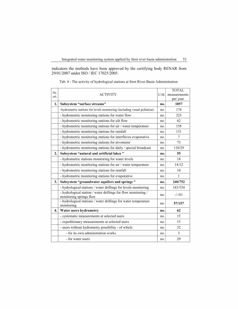
Tab. 4 - The activity of hydrological stations at Siret River Basin Administration
Nr.
crt.ACTIVITY U.M.
TOTAL
measurements
per year
1. Subsystem “surface streams" no. 1057
-hydrometric stations for levels monitoring (including visual pollution) no. 174
- hydrometric monitoring stations for water flow no. 323
- hydrometric monitoring stations for silt flow no. 62
- hydrometric monitoring stations for air / water temperature no. 158
- hydrometric monitoring stations for rainfall no. 131
- hydrometric monitoring stations for interfluves evaporative no. 7
- hydrometric monitoring stations for nivometer no. 73
- hydrometric monitoring stations for daily / special broadcast no. 110/29
2. Subsystem “natural and artificial lakes " no. 55
- hydrometric stations monitoring for water levels no. 18
- hydrometric monitoring stations for air / water temperature no. 14/12
- hydrometric monitoring stations for rainfall no. 10
- hydrometric monitoring stations for evaporative no. 1
3. Subsystem “groundwater aquifers and springs " no. 240/752
- hydrological stations / water drillings for levels monitoring no. 183/534
- hydrological station / water drillings for flow monitoring /
monitoring springs flow no. -/-/61
- hydrological stations / water drillings for water temperature
monitoring no. 57/157
4. Water users hydrometry no. 62
- systematic measurements at selected users no. 15
- expeditionary measurements at selected users no. 15
- users without hydrometry possibility - of which: no. 32
- for its own administration works no. 3
- for water users no. 29

Dan Dăscăliţa 54
In 2010, the application of the 12 types of monitoring programs is
systematically made, according to the analyzed subsystem and having the
configuration from Table 3.
The monitoring network for the water quality in the area of activity of Siret
River Basin Administration for the "rivers" subsystem is systematically covering
2889 km of river from the 10280 km of water courses administered by:
- 88 monitoring water quality sections for streams:
� 10 reference sections; � 17 drinking water sections;
� 21 vulnerable areas sections;
� 39 sections with other monitoring programs; � 1 section of the border.
The rest of the river system is monitored depending on the situation by
investigation monitoring. In sections with high risk of pollution ABAS seeks the quality of surface water through systematic fast flow (daily or weekly frequency as
appropriate). In case of accidental pollution, the monitoring of water resources is
carried in special regime, the monitoring frequency in some cases being hourly.
Quantitative monitoring system of surface water in the area of activity of
the Siret River Basin Administration is done through six hydrological stations, as
follows:
- Suceava Hydrological Station: in the basins of the rivers Siret (up to
Lespezi), Suceava and Moldova (until Timişeşti);
- Vatra Dornei Hydrological Station: in the upper catchment of the river Bistrita (up to the confluence with Neagra river Brosteni)
- Piatra Neamt Hydrological station: in the basins of the rivers Siret (Neamt
county territory), Moldova (lower sector), and Bistrita (middle and lower sectors); - Bacau Hydrological Station: in the middle basin of the Siret river (across
Bacau County) and sub-basin Tazlău;
- Onesti Hydrological Station: in the basin of the river Trotus (without the sub
basin Tazlău);
- Focsani hydrological station: in the lower basin of the Siret river and in the
Putna and Ramnicu Sarat catchments;
- Suha Basin – the representative basin of Suha is organized in the Suha river
basin right tributary of the Moldova river.
Each hydrologic station monitors the water resources for a number of parameters for each subsystem: rivers, lakes, groundwater and wastewater (for
systemic use), through a network of hydrometer, rain and geological stations,
located in characteristic sections with hydromorphological, hydrogeological and
use of water flow specific. This network is presented briefly in Fig. 1, separately
for each hydrological station.
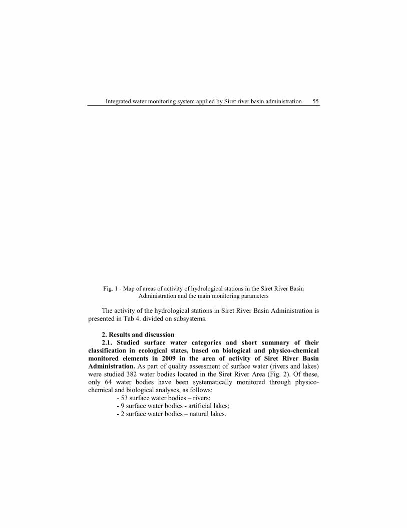
Integrated water monitoring system applied by Siret river basin administration 55
Fig. 1 - Map of areas of activity of hydrological stations in the Siret River Basin
Administration and the main monitoring parameters
The activity of the hydrological stations in Siret River Basin Administration is
presented in Tab 4. divided on subsystems.
2. Results and discussion
2.1. Studied surface water categories and short summary of their
classification in ecological states, based on biological and physico-chemical
monitored elements in 2009 in the area of activity of Siret River Basin
Administration. As part of quality assessment of surface water (rivers and lakes)
were studied 382 water bodies located in the Siret River Area (Fig. 2). Of these, only 64 water bodies have been systematically monitored through physico-
chemical and biological analyses, as follows:
- 53 surface water bodies – rivers; - 9 surface water bodies - artificial lakes;
- 2 surface water bodies – natural lakes.
Dan Dăscăliţa 56
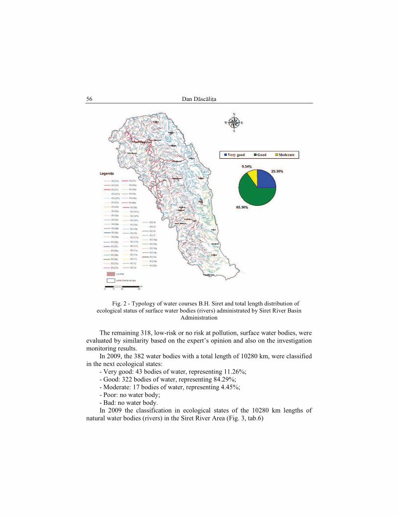
Fig. 2 - Typology of water courses B.H. Siret and total length distribution of
ecological status of surface water bodies (rivers) administrated by Siret River Basin
Administration
The remaining 318, low-risk or no risk at pollution, surface water bodies, were
evaluated by similarity based on the expert’s opinion and also on the investigation
monitoring results.
In 2009, the 382 water bodies with a total length of 10280 km, were classified
in the next ecological states:
- Very good: 43 bodies of water, representing 11.26%;
- Good: 322 bodies of water, representing 84.29%;
- Moderate: 17 bodies of water, representing 4.45%;
- Poor: no water body;
- Bad: no water body. In 2009 the classification in ecological states of the 10280 km lengths of
natural water bodies (rivers) in the Siret River Area (Fig. 3, tab.6)
Integrated water monitoring system applied by Siret river basin administration 57
- Very good: 2600.57 km water bodies, representing 25.30%;
- Good: 6719.30 km water bodies, representing 65.36%;
- Moderate: 960.13 km water bodies, representing 9.34%;
- Poor: 0 km water bodies, representing 0%.
- Bad: 0 km water bodies, representing 0%.
Tab. 5 - The ecological status of the 10280 km of rivers
(km)
10280,00 All rivers, from which
(%)
100,00
4421,90 Km watercourse through systematic monitoring 43,02
5668,78 Km of watercourse through study of similarity 55,14
187,42 Km of watercourse related to 2 accumulation lakes
1,82
1,90 Km of watercourse related to two natural lakes 0,02
Tab. 6 - Synoptic length of water bodies (rivers) cumulated according to the assessment of
the ecological status in 200
Tab. 7 - Distribution of reservoirs according to the assessment of the ecological potential
and chemical status in 2009
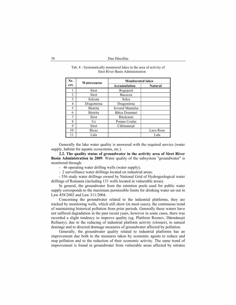
Subsystem “lakes” is monitored by 31 water quality monitoring sections for
11 representative lakes in the area of activity, of which 9 artificial lakes and 2
natural lakes (Tab.8)
Concerning the ecological status of lakes was found that 44% of the 9
monitored accumulation lakes are in moderate state, the remaining 56% being in
good and very good ecological status, while from the two natural lakes, 50% are in
moderate state and the remaining 50% are in good and very good ecological status. Tab. 7 shows the distribution of the 9 lakes according to the assessment of
ecological potential and the chemical quality in 2009.
Dan Dăscăliţa 58
Tab. 8 - Systematically monitored lakes in the area of activity of
Siret River Basin Administration
Monitorated lakes Nr.
crt. Watercourse
Accumulation Natural
1 Siret Rogojesti
2 Siret Bucecea
3 Solcuta Solca
4 Dragomirna Dragomirna
5 Bistrita Izvorul Muntelui
6 Bistrita Bâtca Doamnei
7 Siret Răcăciuni
8 Uz Poiana Uzului
9 Siret Călimaneşti
10 Bicaz Lacu Rosu
11 Lala Lala
Generally the lake water quality is answered with the required service (water
supply, habitat for aquatic ecosystems, etc.).
2.2. The quality status of groundwater in the activity area of Siret River
Basin Administration in 2009. Water quality of the subsystem "groundwater" is
monitored through:
- 46 operating water drilling wells (water supply);
- 2 surveillance water drillings located on industrial areas; - 556 study water drillings owned by National Grid of Hydrogeological water
drillings of Romania (including 131 wells located in vulnerable areas).
In general, the groundwater from the retention pools used for public water supply corresponds to the maximum permissible limits for drinking water set out in
Law 458/2002 and Law 311/2004.
Concerning the groundwater related to the industrial platforms, they are
tracked by monitoring wells, which still show (in most cases), the continuous trend
of maintaining historical pollution from prior periods. Generally these waters have
not suffered degradation in the past recent years, however in some cases, there was
recorded a slight tendency to improve quality (eg. Platform Roznov, Dărmăneşti
Refinery), due to the reducing of industrial platform activity (closure), to natural
drainage and to directed drainage measures of groundwater affected by pollution. Generally, the groundwater quality related to industrial platforms has an
improvement due both to the measures taken by economic agents to reduce and
stop pollution and to the reduction of their economic activity. The same trend of
improvement is found in groundwater from vulnerable areas affected by nitrates

Integrated water monitoring system applied by Siret river basin administration 59
from agricultural activities, mainly due to the reducing of the quantities of nitrogen
fertilizers applied onto agricultural land.
2.3. The quality status of wastewater discharged into the receptors by
economic agents in the activity area of Siret River Basin Administration in
2009. Wastewater subsystem includes 136 pollution sources (of which 107
pollution sources with sewage plants discharge and 29 discharges from rain and
sorting stations of mineral aggregates).
From the total volume of wastewater discharged in 2009 - 106.254 mil.sqm in the activity area of Siret River Basin Administration, 43% were sufficiently treated
and 57% insufficiently treated. Insufficient treatment of sewage water resulted
from the majority of human congestion is mainly due to depreciation of the municipal treatment plants and due to very limited sources of funding for the
development of modern treatment plants. However, the effects of historical
pollution of groundwater is still most common, both on the premises of former industrial sites as on the areas where lands have been heavily polluted by chemical
fertilizers.
Conclusions
The permanent knowledge of water resources status is an objective
requirement which can not be adequately achieved without a modern integrated
water monitoring system. As part of water resource management, monitoring
activity has an important place, representing a major mechanism for quality and
quantity water protection. The Siret River Basin Administration, permanently makes particular efforts to knowledge the status of wastewater quality discharged
and of the impact of these on water resources, namely to decrease until stopping
the quantities of pollutants discharged into water resources. The Administration also acknowledges and takes measures against the economical agents that pollute
so they reduce pollution, so they establish self-monitoring programs and so they
achieve high performance treatment facilities to protect water quality in accordance
with quality standards set by the water legislation.
A positive aspect in recent years is the efficient application by operators of the
self-monitoring programs and of the programs to prevent and control accidental
pollution, under the direct coordination and supervision of qualified staff of the
Siret River Basin Administration. As a result of these measures is the reduction of
the number of accidental pollution from more than thirty accidental pollution cases occurring annually until year 2000 to below 10 accidental pollution cases occurring
annually after 2005.
Among the measures to improve water quality, which Siret River Basin
Administration always pursues are noted:

Dan Dăscăliţa 60
- completion of master plans for the building of wastewater treatment plants
for human agglomerations;
- funding allocation (budget, structural funds, equity) for the development of
new treatment plants for municipalities in B.H. Siret;
- further action to detect polluters who discharge hazardous substances into
sewage systems and natural receivers;
- further studies and action programs in the basin and punctually, so that the
impact of pollution sources on water bodies to be known; - continuous acquisition of materials and installation for the water depollution;
- continuously improvement of the Integrated Monitoring Network at punctual
and overall level. Making the self-monitoring system for treated wastewater discharged into
natural receivers by operators.
All these mentioned measures, and others, are primarily aiming to achieve a good ecological status of water bodies and a sustainable development of water
resources.
References: Dăscăliţa D., Pintilie V. (2001), Integrated monitoring aspects of the aquatic environment
of the Siret River Basin, Scientific Session "Hydro-XXI" - Iasi Polytechnic Institute
Bulletin, Tome XLVII (LI), 1-4 Fascia (II), Iaşi, 2001.
Dăscăliţa D., Movilă I. (2001), Integrated monitoring of aquatic environment in the Siret
River Basin, Hydrotechnic Review, Bucharest, 2001.
Dăscăliţa D. (2005), Water Directorate Siret Bacau - 3 decades of existence, Hydrotechnic
Review, Bucharest, 2005.
*** Framework Directive 2000/60/EC establishing a framework for Community water
policy, Brussels, 2000.
*** Water Law 107/1996 with subsequent amendments.
*** Order 161/2006 for approving the Norms on surface water quality classification in to
establish the ecological status of water bodies.
*** Order 31/2006 approving the Manual for modernization and development of integrated
water monitoring system in Romania (SMIAR).
*** Annual Summary of water quality protection in B.H. Siret - 2009, ABA Siret Bacau, in
2010.
*** ICIM study - "Study on development of classification systems and overall assessment of
status of surface waters (rivers and lakes) - methodology for assessing ecological
status/ ecological potential and chemical status of surface waters as required by the
Framework Directive laying a framework for Community water policy 2000/60/EC,
on the basis of biological, chemical and hydromorphological, Bucharest, 2008.
*** River Basin Management Plan, D.A. Siret Bacau, in 2009.
*** Synthesis of BH cadastral Siret, Siret ABA.
*** Directory of Water Management in B.H. Siret - 2009, ABA Siret Bacau, in 2010.