integrated wayfinding & recommended technologiesf. wayfinding website: accessible by...
TRANSCRIPT
12/2012
Integrated Wayfinding & Recommended Technologies
•TheIntegratedWayfindingExperienceModel
•AssessmentCriteriaforWayfindingSystems
•KeyBenefitsofWayfindingTechnologiesforVAfacilities
•GuidingPrinciplesandBestPractices•SolutionStrategyModel•Platform,DesignandOperationalStrategies
•GaugingtheComplexityofanEnvironment

This page is intentionally left blank.
Integrated Wayfinding & Recommended Technologies
12/2012 Page 2-1
Visitors expect to be able to access navigation and wayfinding information, whether they are at home planning their journey, on their way to a facility, or walking down a corridor to their appointment.
Traditionally, signs and maps have been the major tools to guide people through an environment, and further chapters of this Guide explain the role of signage in wayfinding.
An expanded definition of the term wayfinding recognizes that visitors use multiple cues and tools to find their destination — from spatial relationships manifested by the architecture to lighting and interior finishes.
A new class of wayfinding tools has emerged with the technology revolution. Global positioning system (GPS) devices, websites, apps, and on-site touchscreens can be effective tools to help people along their journey. The smartphone has become our own personal navigation device.
This chapter defines wayfinding technology, its role in helping people find their way, and recommendations for expanding current VA technology tools to serve wayfind-ing needs. It also contains tools to gauge the complexity of an environment so that decisions about deploying wayfinding technology can be made at the facility level.
VA can make visits easier by providing door-to-door directions and on-site tools to guide people effortlessly to their destination, relieving Veterans of some of their anxieties.
Wayfinding is an integral part of the overall visitor experience. For this reason, the solution to any wayfinding problem should be approached from the visitor’s perspective. Beginning with the visitor’s point-of-view to assess and improve the wayfinding experience parallels the Veteran-centric mission of VA and its strategic goals to increase Veteran satisfaction.
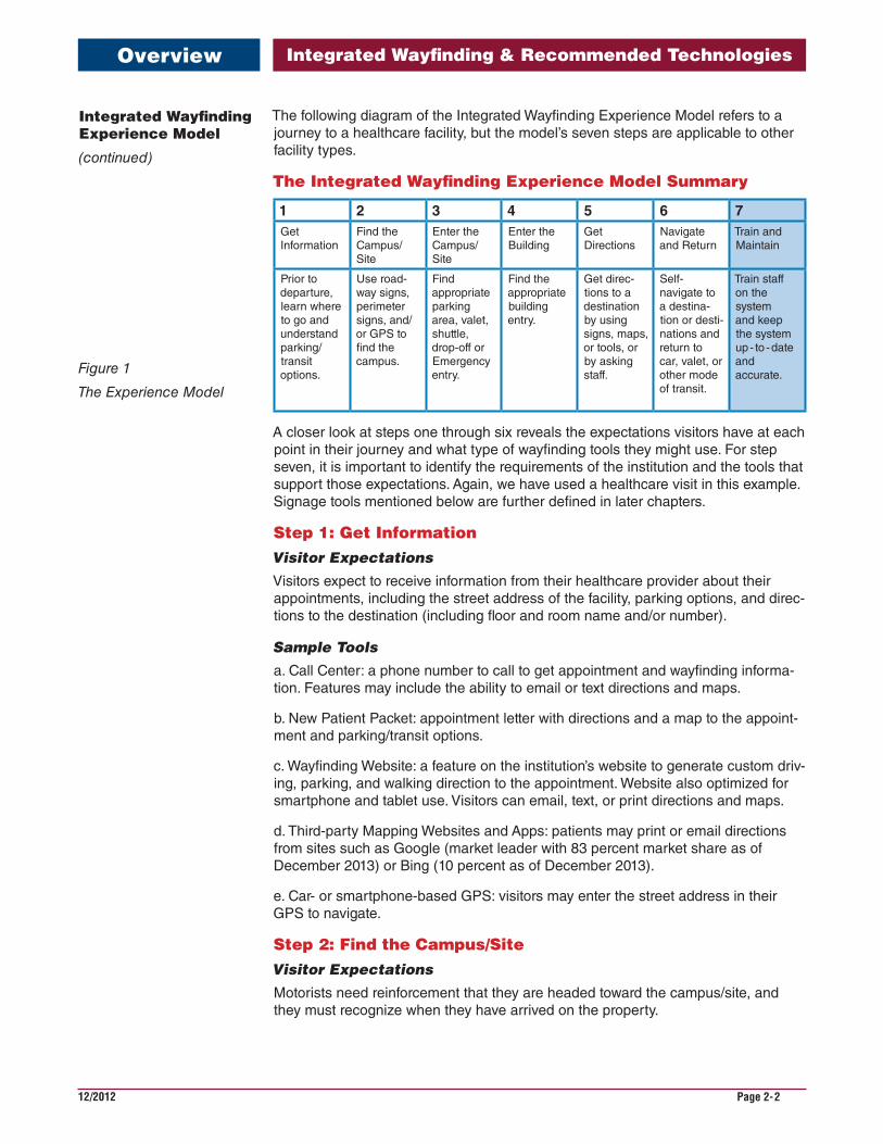
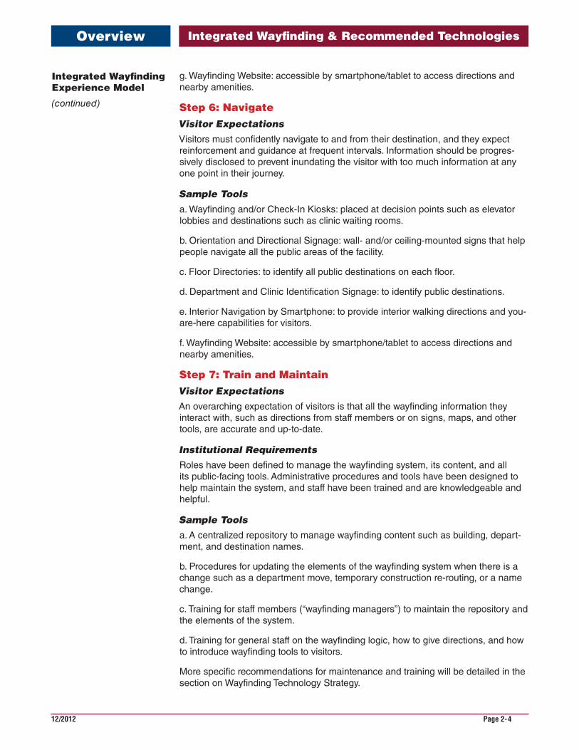
The Experience Model is a framework for structuring both the wayfinding problem and the solution. It is consists of seven steps, as shown in figure 1.
The problem and, ultimately, the solution are detailed within the first six steps, which are representative of a typical visitor’s journey arriving at and traversing the facility. Step seven refers to the critical efforts of training staff to give directions and main-taining the wayfinding system as facilities change and grow.
The model allows us to evaluate wayfinding tools according to the role each plays in a visitor’s journey, and to assess the overall effectiveness of a system based on how much support a visitor has at any one step.
It is important to note that a successful wayfinding program provides tools across various media at every point in the visitor’s journey. For example, some visitors pre-fer to navigate with a printed map, while others choose to follow step-by-step direc-tions. An integrated wayfinding system provides redundant tools across media to help people navigate in whatever manner they prefer.
The term “integrated” means that all wayfinding tools share the same informa-tion — most importantly, the destination names — so that visitors can use any tool in the wayfinding program at any point on their journey to find their destination. An integrated wayfinding system utilizes the same nomenclature, wayfinding logic, and visual language across each element in the system. When a wayfinding system is not integrated, a visitor may receive an appointment letter with directions to “X-Ray” and yet the signs in the facility direct to “Imaging,” resulting in confusion.
Integrated Wayfinding Experience Model
Overview
Need a New Wayfinding System Incorporating Technology?
Integrated Wayfinding & Recommended Technologies
12/2012 Page 2-2
Integrated Wayfinding Experience Model
(continued)
Overview
The following diagram of the Integrated Wayfinding Experience Model refers to a journey to a healthcare facility, but the model’s seven steps are applicable to other facility types.
The Integrated Wayfinding Experience Model Summary
1 2 3 4 5 6 7Get Information
Find the Campus/Site
Enter the Campus/Site
Enter the Building
Get Directions
Navigate and Return
Train and Maintain
Prior to departure, learn where to go and understand parking/transit options.
Use road-way signs, perimeter signs, and/or GPS to find the campus.
Find appropriate parking area, valet, shuttle, drop-off or Emergency entry.
Find the appropriate building entry.
Get direc-tions to a destination by using signs, maps, or tools, or by asking staff.
Self-navigate to a destina-tion or desti-nations and return to car, valet, or other mode of transit.
Train staff on the system and keep the system up - to - date and accurate.
A closer look at steps one through six reveals the expectations visitors have at each point in their journey and what type of wayfinding tools they might use. For step seven, it is important to identify the requirements of the institution and the tools that support those expectations. Again, we have used a healthcare visit in this example. Signage tools mentioned below are further defined in later chapters.
Step 1: Get InformationVisitor Expectations Visitors expect to receive information from their healthcare provider about their appointments, including the street address of the facility, parking options, and direc-tions to the destination (including floor and room name and/or number).
Sample Toolsa. Call Center: a phone number to call to get appointment and wayfinding informa-tion. Features may include the ability to email or text directions and maps.
b. New Patient Packet: appointment letter with directions and a map to the appoint-ment and parking/transit options.
c. Wayfinding Website: a feature on the institution’s website to generate custom driv-ing, parking, and walking direction to the appointment. Website also optimized for smartphone and tablet use. Visitors can email, text, or print directions and maps.
d. Third-party Mapping Websites and Apps: patients may print or email directions from sites such as Google (market leader with 83 percent market share as of December 2013) or Bing (10 percent as of December 2013).
e. Car- or smartphone-based GPS: visitors may enter the street address in their GPS to navigate.
Step 2: Find the Campus/SiteVisitor Expectations Motorists need reinforcement that they are headed toward the campus/site, and they must recognize when they have arrived on the property.
Figure 1
The Experience Model
Integrated Wayfinding & Recommended Technologies
12/2012 Page 2-3
Integrated Wayfinding Experience Model
(continued)
Sample Toolsa. Department of Transportation and City-owned Roadway Signage.
b. Gateways and Thresholds: identify the site and welcome visitors at its perimeter.
c. Campus and Building Identification Signs.
d. Car- or smartphone-based GPS: visitors may enter the street address in their GPS to navigate.
Step 3: Enter the Campus/SiteVisitor Expectations Motorists need big, clear, explicit cues and information that can be easily read from a distance.
Sample Toolsa. Vehicular and Pedestrian Wayfinding Signs: directing to buildings and parking options.
b. Building and Parking Identification Signs.
Step 4: Enter the BuildingVisitor Expectations Visitors need to locate the right building entry from the parking garage, parking lot, or from the street. When there are multiple entrances, they need to find the one closest to their destination.
Sample Toolsa. Building Entry Identification.
Step 5: Get DirectionsVisitor ExpectationsVisitors must intuitively make sense of the environment, orient themselves, and see helpful resources that they can use; the wayfinding system must respond to what they know.
Sample Toolsa. Entrance Lobby Information Desk: a prominent, staffed location where visitors can ask for directions, pick up a map or visitors’ guide, or personalized directions.
b. Printed Map: a facility or campus map and directory of major destinations.
c. Visitors’ Guide: a more detailed version of the printed map, with department phone directory and additional information on services and amenities.
d. Custom Route Maps: pre-printed route cards to major destinations or pre-printed maps that a staff member highlights with custom directions.
e. Wayfinding and/or Check-In Kiosks: well-placed self-service interactive kiosks where visitors can check in for appointments, get directions, or perform other per-sonalized transactions.
f. Interior Navigation by Smartphone: to provide interior walking directions and you-are-here capabilities for visitors.
Overview
Integrated Wayfinding & Recommended Technologies
12/2012 Page 2-4
g. Wayfinding Website: accessible by smartphone/tablet to access directions and nearby amenities.
Step 6: NavigateVisitor Expectations Visitors must confidently navigate to and from their destination, and they expect reinforcement and guidance at frequent intervals. Information should be progres-sively disclosed to prevent inundating the visitor with too much information at any one point in their journey.
Sample Toolsa. Wayfinding and/or Check-In Kiosks: placed at decision points such as elevator lobbies and destinations such as clinic waiting rooms.
b. Orientation and Directional Signage: wall- and/or ceiling-mounted signs that help people navigate all the public areas of the facility.
c. Floor Directories: to identify all public destinations on each floor.
d. Department and Clinic Identification Signage: to identify public destinations.
e. Interior Navigation by Smartphone: to provide interior walking directions and you-are-here capabilities for visitors.
f. Wayfinding Website: accessible by smartphone/tablet to access directions and nearby amenities.
Step 7: Train and MaintainVisitor ExpectationsAn overarching expectation of visitors is that all the wayfinding information they interact with, such as directions from staff members or on signs, maps, and other tools, are accurate and up-to-date.
Institutional RequirementsRoles have been defined to manage the wayfinding system, its content, and all its public-facing tools. Administrative procedures and tools have been designed to help maintain the system, and staff have been trained and are knowledgeable and helpful.
Sample Toolsa. A centralized repository to manage wayfinding content such as building, depart-ment, and destination names.
b. Procedures for updating the elements of the wayfinding system when there is a change such as a department move, temporary construction re-routing, or a name change.
c. Training for staff members (“wayfinding managers”) to maintain the repository and the elements of the system.
d. Training for general staff on the wayfinding logic, how to give directions, and how to introduce wayfinding tools to visitors.
More specific recommendations for maintenance and training will be detailed in the section on Wayfinding Technology Strategy.
Overview
Integrated Wayfinding Experience Model
(continued)

Integrated Wayfinding & Recommended Technologies
12/2012 Page 2-5
Potential Usage of Wayfinding Technology across the Visitor’s Journey
Because the focus of this section is the role of emerging technologies in wayfinding, it is helpful to highlight the technology-based tools and their relevance at each step in the visitor’s journey (steps 1-6) in figure 2.
1 2 3 4 5 6Get Information
Find the Campus/Site
Enter the Campus/Site
Enter the Building
Get Directions Navigate and Return
Wayfinding website
Third - Party websites + apps
GPS
On-site interactive kiosks
Interior navigation by smartphone or tablet
Note that GPS applications and third-party websites and apps focus on public property, with the exception of Google Indoors, which will be explained further in the section on Related VA Initiatives. On-site kiosks, by definition, are specifically an aid to navigating when you are at the facility, although they could direct to other facilities as well.
In conjunction with the Integrated Wayfinding Experience model described above, a series of questions have been developed to help VA staff assess how successful a given wayfinding system may be. These criteria can be used to pinpoint specific points of weakness for further examination.
Reflecting the emphasis on the Veteran-centered approach, seven of the ten criteria evaluate the system from the visitor’s perspective; three evaluate the system from the perspective of administration and operations.
From the Visitor’s Perspective1. Is the experience of navigating the environment intuitive?
Are you aware that you’ve arrived at the right place?
Is there a sense of place? Do you feel welcomed?
Are there coherent vehicular and pedestrian pathways?
Are the technology tools promoted prominently (on-site and on the facility’s website)?
Are the technology tools helpful and intuitive to use?
2. As a first time visitor, is it easy to access the tools you need?
Is there an information desk, information kiosk, and/or greeter at the entrance?
Are on-site technology tools well situated and accessible?
Are tools provided in the population’s main languages?
Are technology tools properly maintained and supported? (Do the printers work, for example?)
3. Is the language friendly, accessible, and consistent?
Assessment Criteria for Wayfinding Systems
Assessment
Integrated Wayfinding Experience Model
(continued)
Figure 2
Emerging Technology in the Experience Model
Integrated Wayfinding & Recommended Technologies
12/2012 Page 2-6
Assessment
Are destination names easy to understand (no acronyms or medical jargon)?
Does the name of the destination on the sign match that on the website and on patient letters, printed maps, and all other wayfinding material?
When symbols or icons are used, are they easy to understand and remember?
4. Is the wayfinding information up-to-date and accurate?
Do directions and maps reflect construction and temporary closures?
Are there “hand-made” signs that differ from the permanently-installed signs?
Is all wayfinding information proactively managed and updated?
5. Are amenities (restrooms, cafés, etc.) easy to find?
If the wayfinding system uses landmarks, such as named elevators or spaces, are they easy to identify and remember?
6. Are the functions of technology tools simple to learn?
Do the technology tools share a common user experience and visual vocabulary?
Are the technology tools accessible to low-vision, hearing impaired, and wheel-chair-bound visitors?
Is there someone able to help a visitor use the technology?
From the Facility Administration Perspective7. Is the wayfinding system easy to maintain (the physical components as well as the content)?
Are wayfinding roles and responsibilities clearly defined?
Is all wayfinding information centralized and “published” to various tools?
When a department is relocated, how quickly are the wayfinding tools updated?
Are the technology tools deeply integrated into relevant systems?
8. Is the wayfinding system seen as a vital contributor to the patient experience?
Is there an approved roadmap that details enhancements and updates?
Is there a maintenance budget available for updates that fall outside defined projects?
Do patient satisfaction surveys ask about wayfinding?
9. Are staff well-trained in using the wayfinding system, its tools, and its nomenclature?
Is wayfinding training a part of new employee orientation?
10. Is there a defined role of “wayfinding manager” responsible for the system and its content?
Is the wayfinding manager knowledgeable about upcoming construction, expan-sion, and renovation projects?
Answers to these questions may trigger further research to resolve problems. For example, if there are many “hand-made” signs in a facility and unclear wayfinding
Assessment Criteria for Wayfinding Systems
(continued)
Integrated Wayfinding & Recommended Technologies
12/2012 Page 2-7
Benefits
responsibilities among the staff, next steps may be to determine how frequently wayfinding information changes at that facility and to identify a point-person to take on the “wayfinding manager” role. Further strategies are defined in the upcoming section on Wayfinding Technology Strategy.
The last few sections have dealt with technology tools as components of an inte-grated wayfinding system. But what are the benefits of implementing wayfinding technology solutions in and of themselves for VA facilities? Six major benefits have been identified.
1. The ubiquity of the Internet and smartphones have dramatically increased expectations of visitors to access information themselves, where and when they need it.
VA leadership explains this shift and a commitment to address these needs in the Department of Veterans Affairs FY 2014-2020 Strategic Plan:
Communications and information technology (IT) will continue to reshape the world. Like the general public, the communication preferences of Veterans and eligible beneficiaries and their families are changing. Veterans and eligible beneficiaries increasingly expect to receive VA communications via the Internet and on mobile devices. VA must embrace and fully support changing mobile lifestyles and personalize that interaction to Veteran needs at that time and place. VA must be able to collect and analyze data to understand our client’s needs and expectations, and personalize the Veteran’s experience with VA. VA needs to be able to adapt to and keep up with the rate of technological change. (page 15)
We live in a connected world. The rapid pace of technological advancement is reshaping Veteran’s expectation regarding how services, benefits, and support should be delivered. Today’s client expects instant access to information and self-service options via the Internet, and increasingly through mobile devices like tablets and smartphones (and the next generation “smart” devices that are yet to be deployed). (page 24)
2. In an era when healthcare choices are expanding — for Veterans as well as for all Americans — offerings that improve patient satisfaction are a competitive advantage.
Medical centers that have adopted wayfinding technology, such as Kaiser Permanente, see it as an increased commitment to serving their communities.
When Kaiser Permanente undertook a broad research initiative to understand the needs of their members (entitled “Creating the Total Healthcare Environment”), two key findings emerged that underscored the relevance of wayfinding technology:
a. The need for understanding the efficiency of the journey to the medical center and point of service… Members expressed the desire to have efficient communication systems for understanding the reception and copay processes, flow, and queuing, and navigating the wayfinding systems for guidance to their locations.
b. The need for convenience, efficiency, and timeliness of service and care. Members are keenly aware of the amount of time invested in waiting, and the uncertainty about when they will be summoned. As stated above, members view this waiting time relative to the whole of their journey. (Creating the Total Health Environment, June 2010, page 21)
Key Benefits of Wayfinding Technology for VA Facilities
Assessment Criteria for Wayfinding Systems
(continued)
Integrated Wayfinding & Recommended Technologies
12/2012 Page 2-8
Benefits
This second point touches on a way that wayfinding technology can assist in the larger mission of integrative care.
Patient satisfaction is a major part of the total brand experience. A successful way-finding system can provide a consistent and tangible expression of the institution’s brand and values. A VA-wide branding effort is underway to articulate and reinforce the brand of VA and its services. For example, VHA interior designers are working with an internal branding team to extend the brand into environments like clinics and hospitals in order to emphasize VA’s mission of patient-centered care. For VA, a coherent set of wayfinding technology tools can support and convey the brand as Veterans and visitors are guided to their destinations.
3. When patients can access a “live” view of their appointments and how to get to them through a kiosk, website, or their smartphone, their time at the healthcare facility can be more efficiently managed.
Appointments can be rescheduled, additional appointments can be added, such as a lab test or a specialist consult, and integrative care can be achieved. Wayfinding technology can support this more complicated patient flow.
The Patient Aligned Care Team (PACT) model that VA employs is primed to take advantage of enhanced scheduling and real-time communication tools such as MyHealtheVet. It is instructive to describe a potential future case, in which PACT supported by wayfinding may speed diagnosis and treatment:
At 10am, a Veteran visits a primary care provider at a CBOC, where during an annual check-up an irregular heartbeat is discovered. The physician performs an electrocardiogram in the exam room and determines that further tests are needed. Those tests are conducted at the VAMC nearby. The clerk schedules the first of these tests for 1pm the same day. The Veteran has never been to the VAMC, so the clerk emails the time and location of the new appointment to the Veteran’s email address. A link to driving, parking, and walking directions to Imaging are included in the email. The Veteran reads the email on his smart-phone (preferred communication method as chosen on MyHealtheVet) and fol-lows directions to the second appointment.
4. A more agile approach to wayfinding, in which wayfinding content can be updated and immediately published to devices, ensures that visitors can navigate an ever - changing environment.
VA facilities are in a constant state of flux from construction, renovation , and relo-cation. In 2015 alone, one billion dollars in major and minor construction is planned. Also included in FY 2015 will be approximately 30 new CBOCs coming on line, mainly through the VA leasing program.
In such variable conditions, the best way to manage change is through a content management system, where changes are identified, impacts to static signage can be quantified, and updated content can be delivered to websites, kiosks, and other tools, all in sync with construction and relocation schedules.
5. In addition to its less tangible benefits of increased patient satisfac-tion, the benefits of wayfinding technology can be quantified.
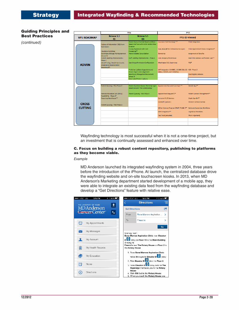
VHA’s Veterans Point of Service Program (VPS) designs, develops, and deploys self-service devices such as VetLink kiosks that provide beneficiaries and employ-ees with clinical and business transactions. Just as a return on investment (ROI) exercise was undertaken by VHA for VPS, ROI could be calculated for the adoption of wayfinding technology. Based on the specific functionality of the recommended
Key Benefits of Wayfinding Technology for VA Facilities
(continued)
Integrated Wayfinding & Recommended Technologies
12/2012 Page 2-9
Benefits
system and its costs, an assessment of its net impact could be estimated, with fac-tors such as:
• decrease in patients who are late for appointments because they are lost or at the wrong location.
• decrease in staff time giving directions.
• decrease in no-shows because patients are lost.
• more efficient management and update of signage.
6. It is an opportune time to identify strategies for wayfinding technology because systems can leverage existing initiatives and programs that are underway at VACO, VHA, and NCA.
Some current VA initiatives are closely aligned to wayfinding, such as the VA Patient-Centered System Navigation Work Group. Others provide existing platforms that can be expanded to publish wayfinding information, such as the VetLink kiosks and VAMC websites. The VetLink kiosk project also provides pertinent lessons learned in the deployment of self-service technology, from planning pilot projects to identifying Integrated Project Team (IPT) members to support the endeavors.
Key Benefits of Wayfinding Technology for VA Facilities
(continued)
Integrated Wayfinding & Recommended Technologies
12/2012 Page 2-10
Strategy
Guiding principles provide the foundation for all best practices, strategies, and tac-tics within a given area of study. The Guiding Principles for wayfinding innovation at VA facilities define what is truly important for a wayfinding system’s success and frame the recommendations that follow. The six Guiding Principles are:
1. Tell visitors what they need to know, when they need to know it, and in the medium they prefer.
2. Maintain consistent nomenclature — the system of names and symbols used to direct visitors to destinations — across all wayfinding tools.
3. From planning through implementation, assure that the wayfinding system addresses the specific needs of the facility and those of its visitors.
4. Design a system that is sustainable, easy to update, and extensible as facili-ties change and grow.
5. Use cost-effective high-impact solutions, leveraging and extending assets and platforms as possible.
6. From the start, create a management plan that identifies the people, pro-cesses and tools to keep wayfinding content accurate and technology operational.
These Guiding Principles are a product of research which included site visits and interviews with staff at VA and comparable institutions.
• Visits to five non-VA healthcare institutions with innovative wayfinding:
Houston Methodist Hospital The University of Texas, MD Anderson Cancer Center Mountain View Center Palo Alto Medical Foundation (Sutter Health) Kaiser Permanente (KP) Oakland Medical Center University of California San Francisco (UCSF) Medical Center, Parnassus Campus and Mission Bay Campus
• Visits with three vendors of wayfinding technology:
22 Miles Google Connexient (via web conference)
• Visits to two VA Medical Centers:
Michael E. DeBakey VA Medical Center, Houston, Texas VA Palo Alto Health Care System, Palo Alto, California
• Visit to one VA National Cemetery:
Golden Gate National Cemetery, San Francisco, California
• Interviews with the Wayfinding Workgroup and other VA stakeholders
• Primary research on wayfinding technologies and innovations
In addition to the site visits and primary research, the findings from industry exper-tise and user research studies (empirical data and user perceptions) along with academic and industry research have contributed to the findings.
The Guiding Principles provide context when designing the solutions outlined in the Recommended Strategies section and should be applied at the beginning of all relevant projects to guide decision-making.
Guiding Principles and Best Practices
Integrated Wayfinding & Recommended Technologies
12/2012 Page 2-11
Strategy
Guiding Principles and Best Practices
(continued)
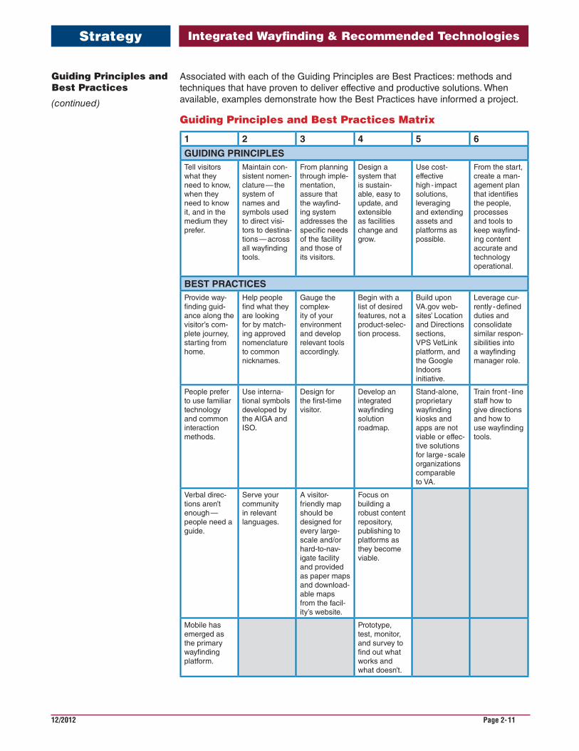
Associated with each of the Guiding Principles are Best Practices: methods and techniques that have proven to deliver effective and productive solutions. When available, examples demonstrate how the Best Practices have informed a project.
Guiding Principles and Best Practices Matrix
1 2 3 4 5 6
GUIDINGPRINCIPLES Tell visitors what they need to know, when they need to know it, and in the medium they prefer.
Maintain con-sistent nomen-clature — the system of names and symbols used to direct visi-tors to destina-tions — across all wayfinding tools.
From planning through imple-mentation, assure that the wayfind-ing system addresses the specific needs of the facility and those of its visitors.
Design a system that is sustain-able, easy to update, and extensible as facilities change and grow.
Use cost-effective high - impact solutions, leveraging and extending assets and platforms as possible.
From the start, create a man-agement plan that identifies the people, processes and tools to keep wayfind-ing content accurate and technology operational.
BESTPRACTICESProvide way-finding guid-ance along the visitor’s com-plete journey, starting from home.
Help people find what they are looking for by match-ing approved nomenclature to common nicknames.
Gauge the complex-ity of your environment and develop relevant tools accordingly.
Begin with a list of desired features, not a product-selec-tion process.
Build upon VA.gov web-sites’ Location and Directions sections, VPS VetLink platform, and the Google Indoors initiative.
Leverage cur-rently - defined duties and consolidate similar respon-sibilities into a wayfinding manager role.
People prefer to use familiar technology and common interaction methods.
Use interna-tional symbols developed by the AIGA and ISO.
Design for the first-time visitor.
Develop an integrated wayfinding solution roadmap.
Stand-alone, proprietary wayfinding kiosks and apps are not viable or effec-tive solutions for large - scale organizations comparable to VA.
Train front - line staff how to give directions and how to use wayfinding tools.
Verbal direc-tions aren’t enough —people need a guide.
Serve your community in relevant languages.
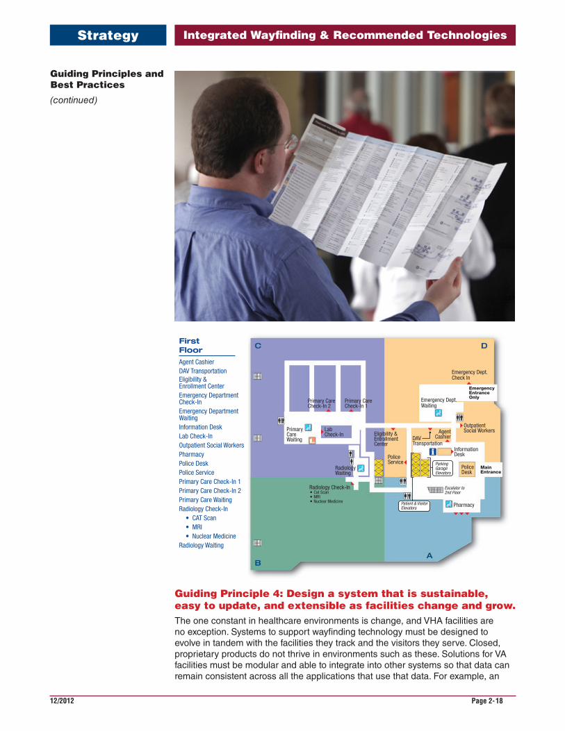
A visitor-friendly map should be designed for every large-scale and/or hard-to-nav-igate facility and provided as paper maps and download-able maps from the facil-ity’s website.
Focus on building a robust content repository, publishing to platforms as they become viable.
Mobile has emerged as the primary wayfinding platform.
Prototype, test, monitor, and survey to find out what works and what doesn’t.
Integrated Wayfinding & Recommended Technologies
12/2012 Page 2-12
Strategy
Guiding Principle 1: Tell visitors what they need to know, when they need to know it, and in the medium they prefer.It is easy to overwhelm visitors with too much information. The concept of progres-sive disclosure — giving people just enough information to complete the current segment of their journey — has been proven to make complex environments simpler to navigate.
There is no single most effective wayfinding tool. Signs, maps, directories, kiosks, apps, and websites must all work together in concert to provide information to visi-tors in the platform and medium that they choose to consult. Visitors often use a variety of tools on a single journey.
Best PracticesA. Provide wayfinding guidance along the visitor’s complete journey, starting from home.
Example
On their websites, MD Anderson Cancer Center (access.mdanderson.org) and UCSF Medical Center (pathway.ucsfmedicalcenter.org) provide driving, parking, and walking directions to all public destinations. Directions are optimized to pro-vide the best place to park to reach that destination. From their homes, visitors can generate a customized, full direction set and print or email it to themselves.
Facilities that only provide on-site kiosks do not fulfill this need: getting from home to the destination. VAMC staff report that Veterans may go to the wrong facility for their appointment, since there is often more than one VHA facility in the area. It is critical to provide accurate driving and transit directions in all com-munications to the patient and on the medical center’s website.
The Integrated Wayfinding Experience Model described in the previous section identifies all the steps of a journey and can help identify gaps.
B. People prefer to use familiar technology and common interaction methods.
In 2014, the most familiar and most-utilized technologies are the web and the smartphone. Touchscreen kiosks, such as ATMs, self - checkout at the super-market, airport check-in, and gas station pumps are part of daily life too.
However, there are no standards in the user interface design for a kiosk, unlike the codified user interface guidelines for an operating system. This means that there is a learning curve associated with every interaction with a new touch-screen kiosk. The user interface should be simply designed, tested at the pro-totype stage, and revised during the design and development phases to ensure high levels of usability.
Guiding Principles and Best Practices
(continued)
Integrated Wayfinding & Recommended Technologies
12/2012 Page 2-13
Strategy
The most successful kiosk implementations are built to serve a single, concise function that can be completed in about a minute or two. Information and com-merce transactions should be simple and helpful.
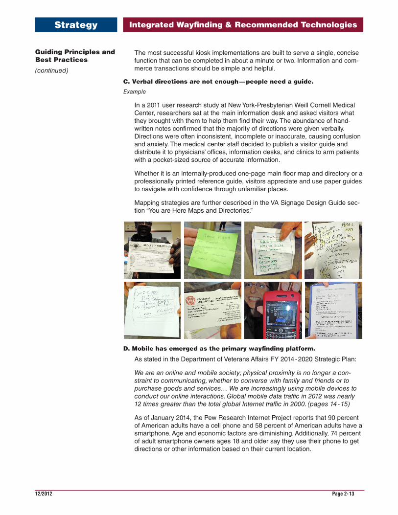
C. Verbal directions are not enough — people need a guide.
Example
In a 2011 user research study at New York-Presbyterian Weill Cornell Medical Center, researchers sat at the main information desk and asked visitors what they brought with them to help them find their way. The abundance of hand-written notes confirmed that the majority of directions were given verbally. Directions were often inconsistent, incomplete or inaccurate, causing confusion and anxiety. The medical center staff decided to publish a visitor guide and distribute it to physicians’ offices, information desks, and clinics to arm patients with a pocket-sized source of accurate information.
Whether it is an internally-produced one-page main floor map and directory or a professionally printed reference guide, visitors appreciate and use paper guides to navigate with confidence through unfamiliar places.
Mapping strategies are further described in the VA Signage Design Guide sec-tion “You are Here Maps and Directories.”
D. Mobile has emerged as the primary wayfinding platform.
As stated in the Department of Veterans Affairs FY 2014 - 2020 Strategic Plan:
We are an online and mobile society; physical proximity is no longer a con-straint to communicating, whether to converse with family and friends or to purchase goods and services… We are increasingly using mobile devices to conduct our online interactions. Global mobile data traffic in 2012 was nearly 12 times greater than the total global Internet traffic in 2000. (pages 14 - 15)
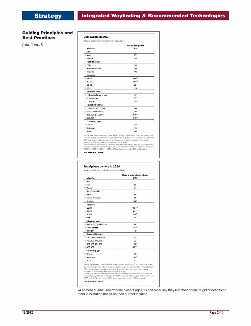
As of January 2014, the Pew Research Internet Project reports that 90 percent of American adults have a cell phone and 58 percent of American adults have a smartphone. Age and economic factors are diminishing. Additionally, 74 percent of adult smartphone owners ages 18 and older say they use their phone to get directions or other information based on their current location.
Guiding Principles and Best Practices
(continued)
4JULY 14, 2011NYP WAYFINDING COMMUNICATIONS
WHAT DO VISITORS ACTUALLY BRING TO THE HOSPITAL?
Findings
The abundance of handwritten notes confirms that the majority of instructions are given verbally
Problems
Inconsistency, variety, inaccuracies occur
Info Desk staff must translate scribbles into actionable instructions
Integrated Wayfinding & Recommended Technologies
12/2012 Page 2-14
Strategy
Guiding Principles and Best Practices
(continued)
74 percent of adult smartphone owners ages 18 and older say they use their phone to get directions or other information based on their current location.
Integrated Wayfinding & Recommended Technologies
12/2012 Page 2-15
Strategy
Guiding Principles and Best Practices
(continued)
Guiding Principle 2: Maintain consistent nomenclature — the system of names and symbols used to direct visitors to destinations — across all wayfinding tools.The importance of using consistent language, especially in a complex healthcare environment, cannot be overstated. When the same destination is referred to as “Diagnostic Imaging” on an appointment letter, “Radiology” on signs, “X-Ray” by the information desk attendant, the visitor is sure to be confused. The deliberate act of documenting and enforcing a single vocabulary of names yields great improve-ments in wayfinding.
Inconsistent names arise from the lack of a centralized approach to wayfinding. An interior designer or facilities manager may be responsible for signage and volunteer services may manage the printed maps. A centralized database, or a single spread-sheet for smaller facilities, can house the approved nomenclature, which can be shared across the organization to use in all public communications.
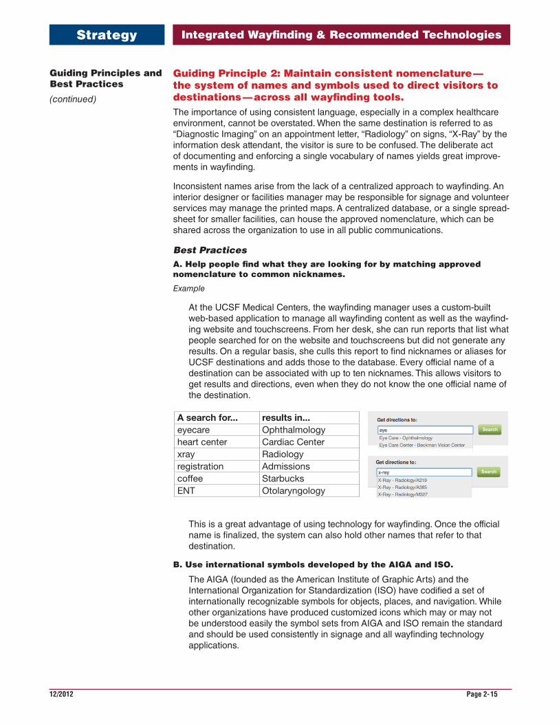
Best PracticesA. Help people find what they are looking for by matching approved nomenclature to common nicknames.
Example
At the UCSF Medical Centers, the wayfinding manager uses a custom-built web-based application to manage all wayfinding content as well as the wayfind-ing website and touchscreens. From her desk, she can run reports that list what people searched for on the website and touchscreens but did not generate any results. On a regular basis, she culls this report to find nicknames or aliases for UCSF destinations and adds those to the database. Every official name of a destination can be associated with up to ten nicknames. This allows visitors to get results and directions, even when they do not know the one official name of the destination.
© 2014 FD2S INC.
A search for... results in...eyecare Ophthalmologyheart center Cardiac Centerxray Radiologyregistration Admissionscoffee StarbucksENT Otolaryngology
Help people find what they are looking for by matching your nomenclature to common nicknames
This is a great advantage of using technology for wayfinding. Once the official name is finalized, the system can also hold other names that refer to that destination.
B. Use international symbols developed by the AIGA and ISO.
The AIGA (founded as the American Institute of Graphic Arts) and the International Organization for Standardization (ISO) have codified a set of internationally recognizable symbols for objects, places, and navigation. While other organizations have produced customized icons which may or may not be understood easily the symbol sets from AIGA and ISO remain the standard and should be used consistently in signage and all wayfinding technology applications.
Integrated Wayfinding & Recommended Technologies
12/2012 Page 2-16
Strategy
C. Serve your community in relevant languages.
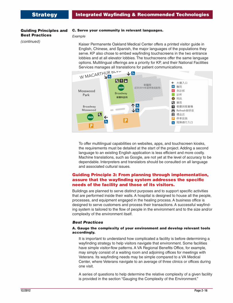
Example
Kaiser Permanente Oakland Medical Center offers a printed visitor guide in English, Chinese, and Spanish, the major languages of the populations they serve. KP also chose to embed wayfinding touchscreens in the two entrance lobbies and at all elevator lobbies. The touchscreens offer the same language options. Multilingual offerings are a priority for KP, and their National Facilities Services manages all translations for patient communications.
Please recycle. This material was produced from eco-responsible resources.
Member and Marketing Communications 89803 [Month] 2013
查詢路線 Oakland Medical Center
• 醫院
• 急診部
• 診所
一般資訊Oakland Medical Center 醫院名錄
醫療中心資訊
問訊 510-752-1000 傳譯服務 1-800-874-9426
我們的網站
請上kp.org/oakland(英文版)了解Oakland Medical Center詳情。
預約與諮詢
一天24小時均可打電話給我們預約或諮詢。
內科 510-752-1190 兒科 510-752-1190 婦女健康(婦產科) 510-752-1100
會員服務聯絡中心
您有問題或顧慮嗎?我們一週7天,一天24小時開放
(假日休息)。
英語 1-800-464-4000 西班牙語 1-800-788-0616 華語方言 1-800-757-7585 TTY聽力與語言障礙者 1-800-777-1370 電傳專線
線上服務
在我們的網站kp.org(英文版)註冊,即可使用
My Health Manager的安全功能。只需進入網站
kp.org/register(英文版),即可開始行動。
健康課程和計劃
在kp.org/classes(英文版)查詢最新時間表,或在
kp.org/healthylifestyles(英文版)開始一項改善健
康的計劃。
地圖未按實際比例
38TH ST
Howe St PiedmontAve
Howe StFABIOLA
BroadwayMRI
Broadway
Broadway
BroadwayMosswood
MosswoodPark
3801
3784
3701
3505
3772 3779
3900
CERRITO
AV
E
新醫院(訂於2014年夏季落成啟用)
病人出院
W MacArthur Blvd
急診入口
280
PIED
MO
NT
AV
E
HO
WE
ST
N
W MACARTHUR BLVD
BRO
AD
WA
Y
3600
Broadway新專科診所
大樓入口
醫院
急診部
診所
問訊
藥房
餐廳與販賣機
Refresh咖啡座
禮品店
停車設施
殘障通行入口
280 W. MacArthur Blvd. 部門 樓層 房間
行政管理部 11 110
入院部 1 15
業務辦公室 1 16
餐廳 1
會議室A, B, C 12 120
急診室 1
家庭護理中心501–524 5 50
禮品店 1
加護病房/過渡護理301–326 3 30
問訊 1
介入性放射科 G G15
分娩和生產/新生兒加護病房 4 40
材料管理 1 19
核子醫學科 2 29
病房601–632 6 60
病房701–732 7 70
病房801–832 8 80
病房901–924 9 90
兒科/兒科加護病房1001–1027 10 100
術前/術後期醫學診所 1 17
藥房—出院 1
放射科 G G10
外科服務 1 14
外科—兒科 1 14
超音波 G G10Oakland Medical Center280 W. MacArthur Blvd., Oakland, CA 94611
To offer multilingual capabilities on websites, apps, and touchscreen kiosks, the requirements must be detailed at the start of the project. Adding a second language to an existing English application is less efficient and more costly. Machine translations, such as Google, are not yet at the level of accuracy to be dependable. Interpreters and translators should be consulted on all language and associated cultural issues.
Guiding Principle 3: From planning through implementation, assure that the wayfinding system addresses the specific needs of the facility and those of its visitors.Buildings are planned to serve distinct purposes and to support specific activities that are performed inside their walls. A hospital is designed to house all the people, processes, and equipment engaged in the healing process. A business office is designed to serve customers and process their transactions. A successful wayfind-ing system is tailored to the flow of people in the environment and to the size and/or complexity of the environment itself.
Best PracticesA. Gauge the complexity of your environment and develop relevant tools accordingly.
It is important to understand how complicated a facility is before determining a wayfinding strategy to help visitors navigate that environment. Some facilities have simple visitor-flow patterns. A VA Regional Benefits Office, for example, may simply consist of a waiting room and adjoining offices for meetings with Veterans. Its wayfinding needs may be simple compared to a VA Medical Center, where Veterans navigate to an average of three clinics or offices during one visit.
A series of questions to help determine the relative complexity of a given facility is provided in the section “Gauging the Complexity of the Environment.”
Guiding Principles and Best Practices
(continued)
Integrated Wayfinding & Recommended Technologies
12/2012 Page 2-17
Strategy
Guiding Principles and Best Practices
(continued)
B. Design for the first-time visitor.
Example
A VHA Interior Designer noted that she and her colleagues have informally tested the efficacy of their wayfinding systems by asking friends, family mem-bers, and university students to find their way to destinations at VA medical centers. Facility staff members know their environment so well, it is important to find ways to see the lobbies, corridors, and clinics through the eyes of a first-time visitor.
When it comes to employing wayfinding technology, it is even more important to design for people who are new to the system. There is a certain wariness about interacting with a new kiosk, device, or app for the first time, and if that interac-tion is unsatisfying, the majority of users will not try it again.
C. A visitor-friendly map should be designed for every large - scale and/or hard - to - navigate facility and provided as paper maps and downloadable maps from the facility’s website.
Examples
Some VHA facilities have produced their own maps and visitor guides; examples include VA Hudson Valley Healthcare System, Baltimore VA Medical Center, and VA Palo Alto Healthcare System. These maps are offered as down-loadable documents from the facilities’ websites as well as at information desks.
As noted above, research has proven that people navigate more confidently when they have something to refer to, such as a map. As usage of smartphones approaches ubiquity, that “something” may be their smartphone and the web, but until that point, a paper map is a trusty aid.
Mapping strategies are further described in the VA Signage Design Guide sec-tion “You are Here Maps and Directories.”
All wayfinding information, maps, and visitor guides require maintenance and update planning, as explained in the following guiding principle.
It is also important to note that the size and complexity of a facility should inform the relevance of wayfinding technology for that visitor population. A series of questions to help determine the relative complexity of a given facility is provided in the section “Gauging the Complexity of the Environment” later in this section.
Integrated Wayfinding & Recommended Technologies
12/2012 Page 2-18
Strategy
Guiding Principle 4: Design a system that is sustainable, easy to update, and extensible as facilities change and grow.The one constant in healthcare environments is change, and VHA facilities are no exception. Systems to support wayfinding technology must be designed to evolve in tandem with the facilities they track and the visitors they serve. Closed, proprietary products do not thrive in environments such as these. Solutions for VA facilities must be modular and able to integrate into other systems so that data can remain consistent across all the applications that use that data. For example, an
RadiationOncology
Emergency Dept.Check In
Emergency Dept.Waiting
OutpatientSocial WorkersAgent
CashierDAVTransportation
PoliceDesk
Eligibility &EntrollmentCenter
PoliceService
Primary CareCheck-In 1
Primary CareCheck-In 2
PrimaryCareWaiting
LabCheck-In
RadiologyWaiting
Radiology Check-In Cat Scan MRI Nuclear Medicine
Pharmacy
Escalator to2nd Floor
ParkingGarageElevators
Patient & VisitorElevators
EmergencyEntranceOnly
MainEntrance
InformationDesk
BasementFloor
Radiation Oncology
Legend
Information
Elevators
Stairs
Waiting Area
Restrooms
Vending
Nurses Station
Restricted Access
FirstFloor
Agent CashierDAV TransportationEligibility & Enrollment CenterEmergency DepartmentCheck-InEmergency DepartmentWaitingInformation DeskLab Check-InOutpatient Social WorkersPharmacyPolice DeskPolice ServicePrimary Care Check-In 1Primary Care Check-In 2Primary Care WaitingRadiology Check-In
• CAT Scan• MRI• Nuclear Medicine
Radiology Waiting
4
Guiding Principles and Best Practices
(continued)
Integrated Wayfinding & Recommended Technologies
12/2012 Page 2-19
Strategy
appointment management database should receive a feed of destination names and their locations from the wayfinding database. When a destination moves, its destination will be automatically updated in patient appointment records.
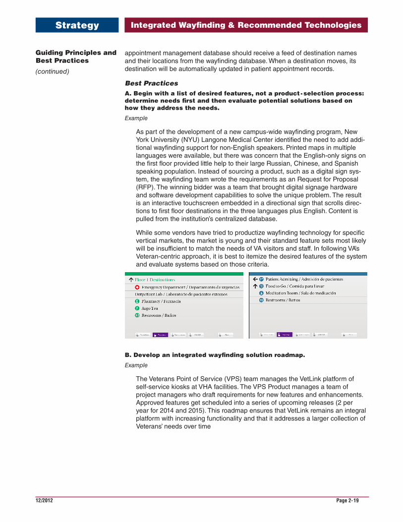
Best PracticesA. Begin with a list of desired features, not a product - selection process: determine needs first and then evaluate potential solutions based on how they address the needs.
Example
As part of the development of a new campus-wide wayfinding program, New York University (NYU) Langone Medical Center identified the need to add addi-tional wayfinding support for non-English speakers. Printed maps in multiple languages were available, but there was concern that the English-only signs on the first floor provided little help to their large Russian, Chinese, and Spanish speaking population. Instead of sourcing a product, such as a digital sign sys-tem, the wayfinding team wrote the requirements as an Request for Proposal (RFP). The winning bidder was a team that brought digital signage hardware and software development capabilities to solve the unique problem. The result is an interactive touchscreen embedded in a directional sign that scrolls direc-tions to first floor destinations in the three languages plus English. Content is pulled from the institution’s centralized database.
While some vendors have tried to productize wayfinding technology for specific vertical markets, the market is young and their standard feature sets most likely will be insufficient to match the needs of VA visitors and staff. In following VA’s Veteran-centric approach, it is best to itemize the desired features of the system and evaluate systems based on those criteria.
B. Develop an integrated wayfinding solution roadmap.
Example
The Veterans Point of Service (VPS) team manages the VetLink platform of self-service kiosks at VHA facilities. The VPS Product manages a team of project managers who draft requirements for new features and enhancements. Approved features get scheduled into a series of upcoming releases (2 per year for 2014 and 2015). This roadmap ensures that VetLink remains an integral platform with increasing functionality and that it addresses a larger collection of Veterans’ needs over time
Guiding Principles and Best Practices
(continued)
Integrated Wayfinding & Recommended Technologies
12/2012 Page 2-20
Strategy
Wayfinding technology is most successful when it is not a one-time project, but an investment that is continually assessed and enhanced over time.
C. Focus on building a robust content repository, publishing to platforms as they become viable.
Example
MD Anderson launched its integrated wayfinding system in 2004, three years before the introduction of the iPhone. At launch, the centralized database drove the wayfinding website and on-site touchscreen kiosks. In 2013, when MD Anderson’s Marketing department started development of a mobile app, they were able to integrate an existing data feed from the wayfinding database and develop a “Get Directions” feature with relative ease.
Guiding Principles and Best Practices
(continued)
Integrated Wayfinding & Recommended Technologies
12/2012 Page 2-21
Strategy
It is difficult to plan for the adoption of new technologies and devices more than five years into the future. However, when the center of the system is a database of accurate content, that content can be published to various devices as they gain traction in the marketplace.
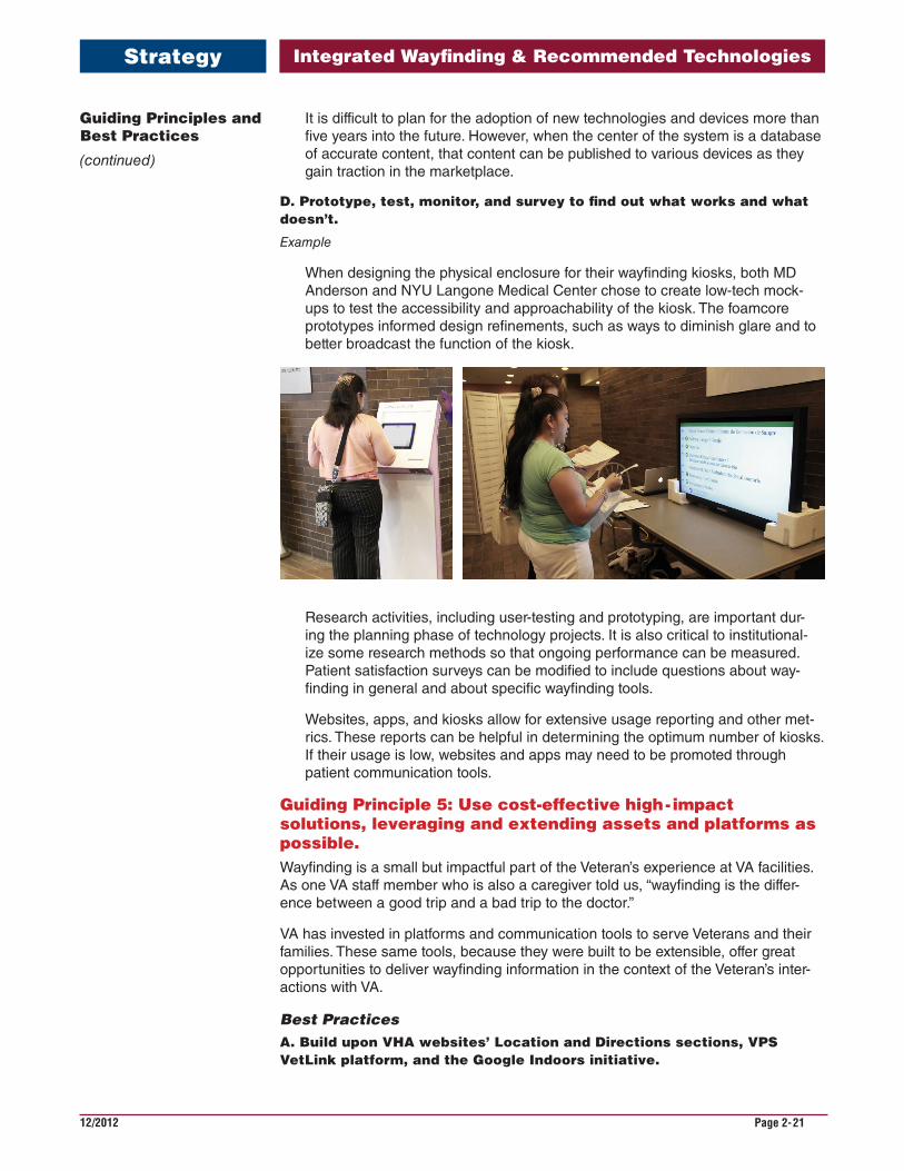
D. Prototype, test, monitor, and survey to find out what works and what doesn’t.
Example
When designing the physical enclosure for their wayfinding kiosks, both MD Anderson and NYU Langone Medical Center chose to create low-tech mock-ups to test the accessibility and approachability of the kiosk. The foamcore prototypes informed design refinements, such as ways to diminish glare and to better broadcast the function of the kiosk.
Research activities, including user-testing and prototyping, are important dur-ing the planning phase of technology projects. It is also critical to institutional-ize some research methods so that ongoing performance can be measured. Patient satisfaction surveys can be modified to include questions about way-finding in general and about specific wayfinding tools.
Websites, apps, and kiosks allow for extensive usage reporting and other met-rics. These reports can be helpful in determining the optimum number of kiosks. If their usage is low, websites and apps may need to be promoted through patient communication tools.
Guiding Principle 5: Use cost-effective high - impact solutions, leveraging and extending assets and platforms as possible.Wayfinding is a small but impactful part of the Veteran’s experience at VA facilities. As one VA staff member who is also a caregiver told us, “wayfinding is the differ-ence between a good trip and a bad trip to the doctor.”
VA has invested in platforms and communication tools to serve Veterans and their families. These same tools, because they were built to be extensible, offer great opportunities to deliver wayfinding information in the context of the Veteran’s inter-actions with VA.
Best PracticesA. Build upon VHA websites’ Location and Directions sections, VPS VetLink platform, and the Google Indoors initiative.
Guiding Principles and Best Practices
(continued)

Integrated Wayfinding & Recommended Technologies
12/2012 Page 2-22
Strategy
Upon review of the related wayfinding and technology initiatives within VA, there are three platforms/assets that provide foundations for building wayfinding resources for visitors.
VAMC websites already provide driving directions and links to maps to help Veterans get to their facilities. These sections could be enhanced to provide customized maps and information on interior wayfinding, consolidating all wayfinding information for the facility in the one area. Implementing a system of standardized destination nomenclature will be a key to a successful expansion of directions on VAMC websites.
VetLink is positioned to be the centralized point of service for an expanding set of Veteran interactions. Currently, VetLink includes an optional wayfinding mod-ule with limited functionality. It has not been deployed in many sites. The VetLink deployment currently numbers more than 3,315 kiosks in 95 VHA facilities. With expanded directions capabilities, VetLink is poised to be the primary platform for communicating on-site directions to Veterans and visitors.
Through the Google Indoors initiative VA has begun a working relationship with the largest and most accurate provider of maps and directions. Google Indoors is not yet marketed and promoted to Google users, so awareness of its features is currently low. But, as Google achieves critical mass of floor plans, they are sure to launch marketing and promotional efforts to introduce its capabilities to their users.
B. Stand-alone, proprietary wayfinding kiosks and apps are not viable solutions for large-scale organizations comparable to VA.
It is critical to understand the shortcomings of stand-alone wayfinding kiosks. The majority of wayfinding kiosks that have been purchased on an ad hoc basis by VAMCs are unsupported, not functioning and/or not providing up-to-date information. It is recommended that VA consider a moratorium on the purchase of proprietary wayfinding kiosks and instead invest in the expansion of current systems to provide wayfinding functionality to Veterans and their families.
Guiding Principle 6: From the start, create a management plan that identifies the people, processes, and tools to keep wayfinding content accurate and technology operational.As emphasized throughout this section, wayfinding content must be kept up-to-date to be helpful to visitors. It is not a one-time project, but an institutional responsibility that must be identified and supported with processes and tools. It is important to begin any wayfinding project with this understanding and with a plan for keeping the content accurate.
It is also relevant to note that wayfinding updates cannot only be project-driven or scoped as part of funded construction projects. Wayfinding changes occur outside construction projects, for example, name changes of destinations, relocations of offices and clinics, and require constant supervision and consistent operational support.
When wayfinding technology is a part of the overall wayfinding strategy, there are additional maintenance responsibilities to keep the software, hardware, and net-working components up and running.
Best PracticesA. Leverage currently-defined duties and consolidate similar responsibili-ties into a wayfinding manager role.
Guiding Principles and Best Practices
(continued)
Integrated Wayfinding & Recommended Technologies
12/2012 Page 2-23
Strategy
A collection of responsibilities has been identified that support wayfinding:
• Interior designers at VAMCs are responsible for maintaining and updating signage, including wayfinding signs.
• The Public Affairs Officer at VAMCs is responsible for keeping the VA.gov website for their facility up to date, including driving directions, maps, and parking information.
• Voluntary Services manages volunteers who give directions at information desks and aid Veterans in using VetLink, among other responsibilities.
• For VHA facilities that are deploying VPS VetLink kiosks, there are integrated project teams (IPTs) responsible for aiding in implementation, determining kiosk locations, running kiosk reports, and managing any wayfinding content that may be offered through VetLink.
• For the Google Indoors Initiative, IPTs have been assigned to gather floor plans and department information to deliver to Google and are responsible for updating that information as needed.
In evaluating non-VA institutions with robust wayfinding programs, those with dedicated, centralized staff to manage the content and hardware/software have proven to be the most successful and the most sustainable over time.
It is not within the scope of this document to recommend a staffing plan for way-finding management, but it is important to understand that there is a collection of responsibilities that must be identified and operationalized for the system to be effective.
B. Train front-line staff how to give directions and how to use wayfinding tools.
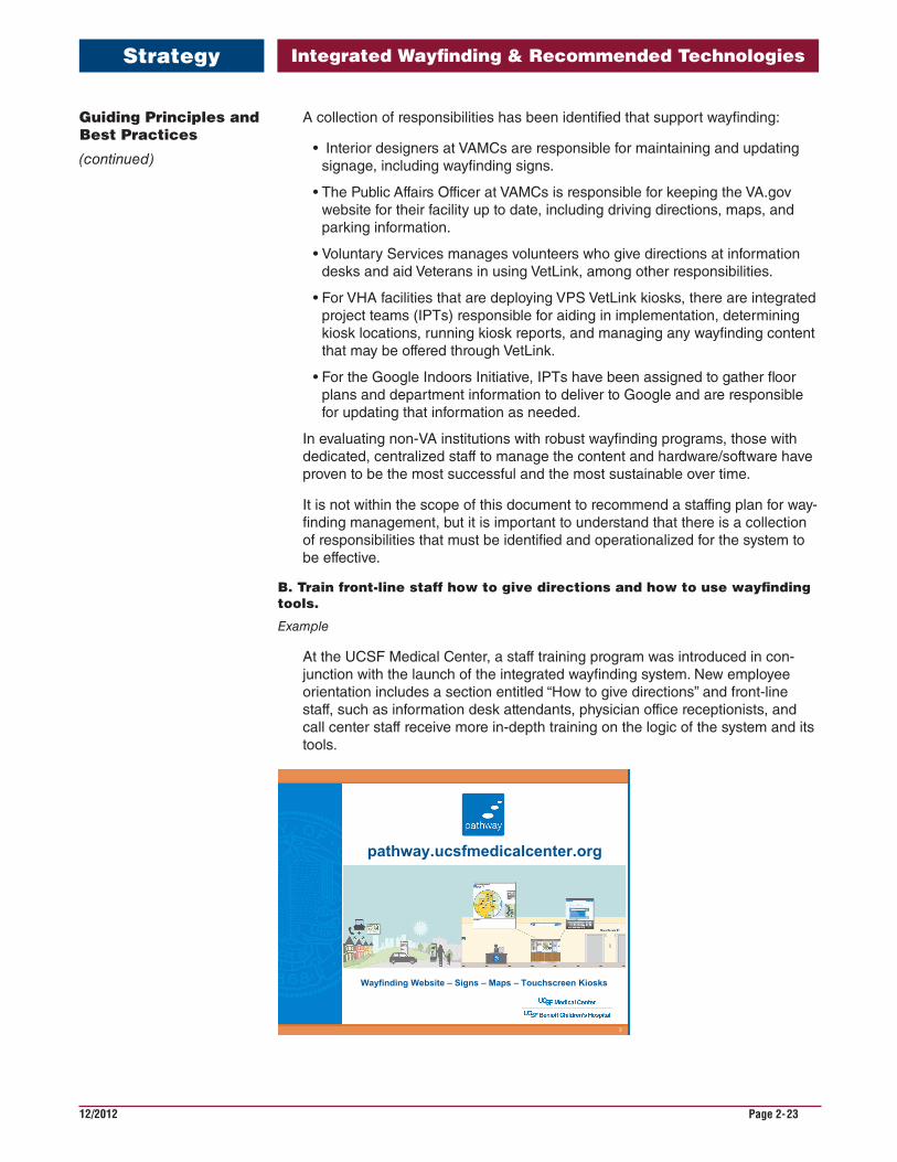
Example
At the UCSF Medical Center, a staff training program was introduced in con-junction with the launch of the integrated wayfinding system. New employee orientation includes a section entitled “How to give directions” and front-line staff, such as information desk attendants, physician office receptionists, and call center staff receive more in-depth training on the logic of the system and its tools.
2
Wayfinding Website – Signs – Maps – Touchscreen Kiosks
pathway.ucsfmedicalcenter.org
Guiding Principles and Best Practices
(continued)
Integrated Wayfinding & Recommended Technologies
12/2012 Page 2-24
3
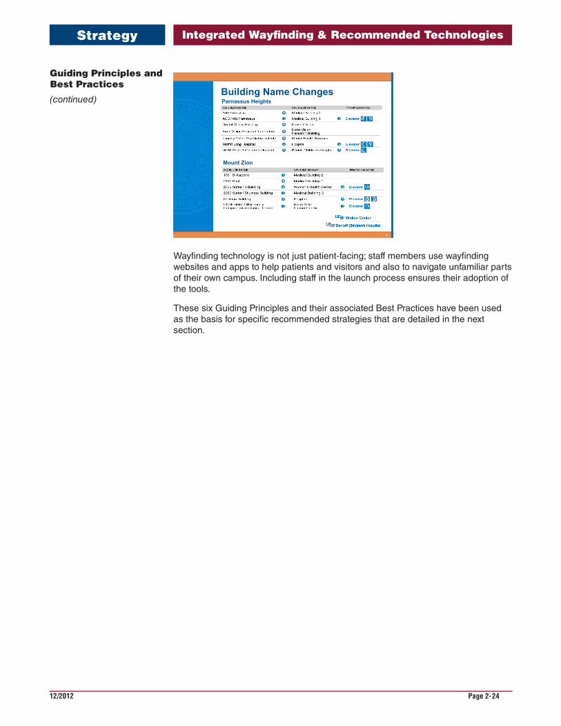
Building Name ChangesParnassus Heights
Mount Zion
Wayfinding technology is not just patient-facing; staff members use wayfinding websites and apps to help patients and visitors and also to navigate unfamiliar parts of their own campus. Including staff in the launch process ensures their adoption of the tools.
These six Guiding Principles and their associated Best Practices have been used as the basis for specific recommended strategies that are detailed in the next section.
Guiding Principles and Best Practices
(continued)
Strategy
Integrated Wayfinding & Recommended Technologies
12/2012 Page 2-25
An Integrated Approach: Solution Strategy Model
Strategy
All of the guidance about wayfinding systems and technology in the previous sec-tions pertain to VA facilities as a whole. This section delves deeper into strategies to deliver enhanced wayfinding information to visitors via relevant technologies — all tuned to serve the specific needs of Veterans and their caregivers and families.
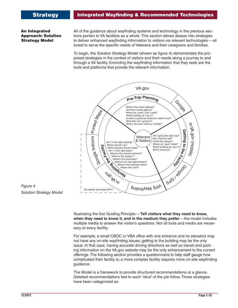
To begin, the Solution Strategy Model (shown as figure 4) demonstrates the pro-posed strategies in the context of visitors and their needs along a journey to and through a VA facility. Encircling the wayfinding information that they seek are the tools and platforms that provide the relevant information.
Veterans& Visitors
What is the street address?Are there transit options?Where do I park? Can I valet?Which building do I go in?Is there a particular entrance I need to use?What floor am I going to?What’s the room name or number?
Am I going the right way?Did I miss the exit?Is this the campus?Where do I park? Valet?Which building do I go in?Which entrance?
Am I in the right building? Where should I go? Which elevator should I take? Am I in the right place? Where’s the nearest restroom? Where’s the canteen? Where’s the pharmacy? Where’s my next appointment? Where’s the business office? Where did I park?
VA.gov
Googlem
.VA.gov (mobile)
Google / GPSVPS Wayfinding m
.VA.go
vGo
ogle
Indo
ors
Prin
ted
Map
sPre-Trip Planning
Navigating
the F
acili
ty
Getting to the Facility
Via cellular and Guest Wi-Fi
Illustrating the first Guiding Principle — Tellvisitorswhattheyneedtoknow,whentheyneedtoknowit,andinthemediumtheyprefer — the model includes multiple media to answer the visitor’s questions. Not all tools and media are neces-sary at every facility.
For example, a small CBOC or VBA office with one entrance and no elevators may not have any on-site wayfinding issues; getting to the building may be the only issue. In that case, having accurate driving directions as well as transit and park-ing information on the VA.gov website may be the only enhancement to the current offerings. The following section provides a questionnaire to help staff gauge how complicated their facility is; a more complex facility requires more on-site wayfinding guidance.
The Model is a framework to provide structured recommendations at a glance. Detailed recommendations tied to each “slice” of the pie follow. Those strategies have been categorized as:
Figure 4
Solution Strategy Model
Integrated Wayfinding & Recommended Technologies
12/2012 Page 2-26
An Integrated Approach: Solution Strategy Model
(continued)
• Platform Strategies address the systems required to deliver wayfinding infor-mation and their integration and expansion points.
• Design Strategies address planning, usability, and lists of recommended fea-tures from the visitor’s point of view.
• Operational Strategies address recommendations on the roles, processes and tools to maintain the system.
It is important to note that this Model represents technologies, including the web, mobile devices, and self-service kiosks that are in use today and will continue to be vital wayfinding tools for the next five years. The Model may be revised over time to include emerging technologies as they gain traction in the marketplace and among VA visitor demographics.
The Model divides the visitor’s journey into three sections, pre-trip planning, getting to the facility, and navigating the facility.
Pre-Trip PlanningToday, the “Locations” section of VA.gov for medical centers and clinics offers street addresses and, in some cases, driving directions and other details for VHA facili-ties. The recommendation is to expand the information to answer all of the most frequently-asked questions for every facility.
The NCA website “Locations” provides a map to all National Cemeteries with the name of the cemetery by state and the street address, with directions from the nearest airport. The National Gravesite Locator provides the Veteran’s name, branch of service, rank, dates of birth and death, name and location of cemetery, and the location of the burial site shown on a printable map.
As noted in the Integrated Wayfinding Experience Model (Figure 1), most people who look for directions online start with Google (83 percent in December 2013), so it is important that Google’s location information for VA facilities, beginning with the each facility’s street address is accurate. As a byproduct of the Google Indoors initiative street addresses will be checked for accuracy.
Getting to the FacilityToday, VA.gov is not optimized for mobile devices, meaning that it is hard to navi-gate and read the website from a smartphone or tablet. The site displays the same content in the same format, regardless of the size of the screen of the device that is accessing it. A responsive website serves content and tools in the best format for each device that accesses it. VA.gov is scheduled to re-launch as a responsively-designed site in August 2014. At that time, visitors will be able to access and refer to location information more easily.
Navigating the FacilityOnce on site, the visitor should have access to wayfinding information in various media. The VPS system provides a platform to support on-site wayfinding touch-screens, relevant wayfinding information embedded in check-in kiosks, and other devices such as tablets as the platform offerings grow. If the facility has adequate cellular coverage, or even better, a guest wireless network, the visitor can con-tinue to use his or her smartphone indoors to access VA.gov and Google Indoors. Several VA Medical Centers have chosen to establish guest wireless networks using facility funds, since there is not a national guest wireless strategy. For compli-cated campuses or facilities, a printed map should be available at entrance lobbies and major information desks.
Solution
Integrated Wayfinding & Recommended Technologies
12/2012 Page 2-27
Recommended Strategies
Solution
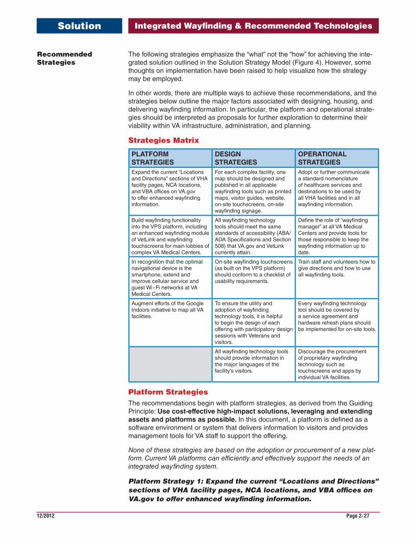
The following strategies emphasize the “what” not the “how” for achieving the inte-grated solution outlined in the Solution Strategy Model (Figure 4). However, some thoughts on implementation have been raised to help visualize how the strategy may be employed.
In other words, there are multiple ways to achieve these recommendations, and the strategies below outline the major factors associated with designing, housing, and delivering wayfinding information. In particular, the platform and operational strate-gies should be interpreted as proposals for further exploration to determine their viability within VA infrastructure, administration, and planning.
Strategies Matrix
PLATFORMSTRATEGIES
DESIGNSTRATEGIES
OPERATIONALSTRATEGIES
Expand the current “Locations and Directions” sections of VHA facility pages, NCA locations, and VBA offices on VA.gov to offer enhanced wayfinding information.
For each complex facility, one map should be designed and published in all applicable wayfinding tools such as printed maps, visitor guides, website, on-site touchscreens, on-site wayfinding signage.
Adopt or further communicate a standard nomenclature of healthcare services and destinations to be used by all VHA facilities and in all wayfinding information.
Build wayfinding functionality into the VPS platform, including an enhanced wayfinding module of VetLink and wayfinding touchscreens for main lobbies of complex VA Medical Centers.
All wayfinding technology tools should meet the same standards of accessibility (ABA/ADA Specifications and Section 508) that VA.gov and VetLink currently attain.
Define the role of “wayfinding manager” at all VA Medical Centers and provide tools for those responsible to keep the wayfinding information up to date.
In recognition that the optimal navigational device is the smartphone, extend and improve cellular service and guest Wi - Fi networks at VA Medical Centers.
On-site wayfinding touchscreens (as built on the VPS platform) should conform to a checklist of usability requirements.
Train staff and volunteers how to give directions and how to use all wayfinding tools.
Augment efforts of the Google Indoors initiative to map all VA facilities.
To ensure the utility and adoption of wayfinding technology tools, it is helpful to begin the design of each offering with participatory design sessions with Veterans and visitors.
Every wayfinding technology tool should be covered by a service agreement and hardware refresh plans should be implemented for on-site tools.
All wayfinding technology tools should provide information in the major languages of the facility’s visitors.
Discourage the procurement of proprietary wayfinding technology such as touchscreens and apps by individual VA facilities.
Platform StrategiesThe recommendations begin with platform strategies, as derived from the Guiding Principle: Usecost-effectivehigh-impactsolutions,leveragingandextendingassetsandplatformsaspossible.In this document, a platform is defined as a software environment or system that delivers information to visitors and provides management tools for VA staff to support the offering.
None of these strategies are based on the adoption or procurement of a new plat-form. Current VA platforms can efficiently and effectively support the needs of an integrated wayfinding system.
Platform Strategy 1: Expand the current “Locations and Directions” sections of VHA facility pages, NCA locations, and VBA offices on VA.gov to offer enhanced wayfinding information.
Integrated Wayfinding & Recommended Technologies
12/2012 Page 2-28
VA has implemented a template approach to organizing information on all of its facilities. As described in the Related VA Initiatives section, VHA Media Management oversees the national and local content for VA.gov and has designed a series of templates for each VHA, VBA, and NCA facility to publish information. Representatives at the facility level, such as the Public Affairs Officer at the VAMC, manage the content on their pages, including the Locations section.
Today, the Locations section offers driving directions with the option to generate customized directions and a map from any street address to the facility’s street address via a Google Maps link. Links to see the facility’s location on Yahoo, MapQuest, and Google are also provided.
An effort could be defined to expand the wayfinding information provided on the Locations page. All facility website Location pages should include a site plan not-ing entrances and major destinations. The map could be a Google Indoors map (or Google’s standard map, if the facility hasn’t been mapped) to the facility. Options could be provided to generate customized driving or transit, parking, and walking directions to any destination at that facility. (The facility web pages list Healthcare Services provided at each facility; those could also have links to generate complete direction sets, using standard nomenclature.) Since all VBA, VHA and NCA facilities have Location pages, this solution would be helpful for all VA visitors.
Additional functions to print, email, or text direction sets should be accessible from every set of directions.
As the Solutions Model indicates, there is significant value in making VA.gov a more helpful tool for smartphone and tablet users. Twenty-one percent of traffic to VA.gov comes from smartphones and tablets. When the site is responsively designed in August 2014, all visitors will essentially have a visitor guide to the complete network of VA facilities in their pocket.
Platform Strategy 2: Build wayfinding functionality into the VPS platform, including an enhanced wayfinding module of VetLink and wayfinding touchscreens for main lobbies of complex VA Medical Centers.VPS was designed as a platform for self-service transactions at VHA facilities. It debuted in May 2011 with VetLink kiosks, and their main function is patient check in.
Since inception, the VPS charter has been “device-agnostic” so that the platform can run and manage any device, as needs are identified. Aside from the free-stand-ing and desk-mounted VetLink kiosks, the VPS system currently supports many different form-factors, including 42-inch touchscreens.
A process already exists by which new functions, such as facility/campus wayfind-ing, can be defined, along with user interface and content requirements. With more than 3,315 devices in use in VAMCs and CBOCs, the methodologies for deploy-ment and operations have been honed and codified.
Platform Strategy 3: In recognition that the optimal navigational device is the smartphone, extend and improve cellular service and guest Wi-Fi networks at VA Medical Centers.As explained in the first Guiding Principle’s Best Practice: Mobile has emerged as the primary wayfinding platform, it is clear that the smartphone has become the personal wayfinding device.It already is an aid to visitors in their journey to facilities. But once inside, when cellular service is low or non-existent, and there is no guest Wi-Fi network, the smartphone is of no help.
Recommended Strategies
(continued)
Solution
Integrated Wayfinding & Recommended Technologies
12/2012 Page 2-29
Recommended Strategies
(continued)
Solution
There are many reasons to pursue a guest Wi-Fi initiative. Significantly, there are therapeutic benefits for patients in long-term confinement at VA medical centers, as identified by VHA Office of Research & Development, Bioinformatics in a proposal for a national Veterans guest internet access (VGIA) initiative.
Guest Wi-Fi may also be a key driver of patient satisfaction and, perhaps, even a point of comparison as Veterans have more choices whether they seek care within VA or in the new options offered by the Affordable Care Act.
Some VAMCs offer guest Wi-Fi today, and it is being considered by many others. As business cases are drafted, it is important to note the benefits of delivering real-time wayfinding information via Wi-Fi to visitors. However, a major constraint is that VAMCs must finance this provision at the facility level since no separate funding is available.
Indoor positioning technology offers the ability to locate the position of a user’s smartphone indoors and deliver relevant information to that user based on his or her position. The location of the smartphone can be pinpointed by triangulat-ing nearby Wi-Fi signals or by more sophisticated sensors either in the phone or embedded in the environment.
Cisco, the market leader in Wi-Fi networking hardware and software, is embedding location intelligence in its access points (also known as wireless routers) so that apps and websites can identify the position of the user indoors and deliver contex-tual information (such as nearby restrooms and amenities or directions to a destina-tion), regardless of whether the user’s smartphone is on the Wi-Fi network.
Cisco’s is a more proprietary approach than Google’s: Cisco is embedding location information in the Cisco access point to be used by apps designed specifically to access and process that data; Google is sensing any wireless signal and recording where destinations are according to the user’s position as identified by surrounding wireless signals.
Platform Strategy 4: Augment efforts of the Google Indoors initia-tive to map all VA facilities.By every measure, Google is the market leader in navigation. Google Maps for Mobile is the world’s most popular app for smartphones, with over 54 percent of global smartphone owners using it at least once during the month of August 2013. Ninety-one percent of all U.S. smartphones have access to Google Maps. From Street View to Google Earth, Google spends millions of dollars updating and grow-ing its mapping data. Google launched Indoor Maps in 2011 and an estimated 25,000 facilities all over the world have been mapped, with malls, airports, and museums in the lead. Google Indoors is accessible by any device that can access Google Maps.
Google’s Indoor initiative is composed of two parts, (1) publishing indoor floor plans with labeled destinations aligned to Google’s base maps and (2) walking the space with Google’s proprietary tools to provide indoor location positioning on those maps (linking the virtual maps to the physical environment via detection of wireless signals’ strength and location). The destinations on the indoor maps are part of Google’s database and are searchable, meaning that you can find directions from your location at the hospital’s entrance lobby on Floor 1 to Dialysis on Floor 3. (Note that destination names would best be standardized through a VA-wide nomencla-ture initiative.)
If the facility has any visible Wi-Fi network (publicly accessible or staff-facing, secure or open), then Google will survey the facility, using specialized software that
Integrated Wayfinding & Recommended Technologies
12/2012 Page 2-30
records the strength and location of access points to “stitch” the static floorplan to locations in physical space.
Google Indoors works best when (1) the facility has given Google the floorplans to publish and (2) the facility has a Wi-Fi network of any kind (public/private, secure/open) and (3) the Google team has mapped that facility to record where destina-tions are based on sensing the Wi-Fi signals. When all three are complete, then people can see the “You are here” blue dot on the floorplan on Google Maps and can navigate easily to any destination in the building, checking their progress on the map.
If Google has published the floorplans (1) above, then people can see the floorplan on Google Maps and can use the map to navigate, even though the map does not show the “You are here” blue dot. In other words, they can refer to the indoor map to navigate, but cannot see where they are on the map or check their progress toward their destination. In this case, it does not matter whether the facility has a Wi-Fi network.
Other companies are pursuing the “You are here” functionality indoors, but rely on additional network infrastructure such as intelligent access points that track location or installation of Bluetooth/iBeacon sensors.
Interior destinations labeled on Google Indoors maps are also searchable from Google’s main search engine (www.google.com.) For example, if “Radiology” is a labeled destination on the VA Pittsburgh H. J. Heinz Campus building floorplan, then a visitor to Google search will find “Radiology, VA Pittsburgh H. J. Heinz Campus” as a search result with a map to that destination. When a facility has been mapped, Google will be able to offer more specific directions to destinations within that facility.
Knowledge of Google Indoors is relatively low in the marketplace, meaning that Google Maps users only stumble upon it when they happen to search for a destina-tion that has indoor maps. As more and more locations have indoor maps, more people will be exposed to the feature.
Google Indoors is now part of the developer toolkit, or API, that Google makes available to third-party developers to make their own custom applications based on the Google Map platform. That means that the functionality demonstrated on the UCSF and MD Anderson websites (customized driving, transit, parking, walk-ing directions to an interior destination) can be developed on VA.gov or in VA Connected Health app, MyHealtheVet.
The recommendation to continue to pursue and expand this initiative is based on:
• Google’s dominance in mapping as the primary navigational tool.
• Functionality provided by Google Indoors, including “You are here.”
• Capability to embed Google Indoor maps in VA.gov location pages.
Design StrategiesDesign strategies identify the major usability requirements for wayfinding tools. While tuned for wayfinding technology tools, many of these design strategies may be applied to more pervasive tools, such as printed communications.
Design Strategy 1: For each complex facility, one map should be designed and published in all applicable wayfinding tools, including
Recommended Strategies
(continued)
Solution
Integrated Wayfinding & Recommended Technologies
12/2012 Page 2-31
Recommended Strategies
(continued)
Solution
printed maps, visitor guides, website, on-site touchscreens, and on-site wayfinding signage. As stated in the Guiding Principles Best Practice: Verbaldirectionsarenotenough—peopleneedaguide. Probably the most effective portable wayfinding tool is a printed map.
Recommendations for map design are described in the VA Signage Design Guide section on “You are here” Maps and Directories.
Whether they are produced by in-house designers or by outside consultants, printed maps orient visitors and help them form a mental model of a complicated environment.
Maps do need to be updated as facilities change and grow and should be overseen by the wayfinding manager as described in Operational Strategies below.
Design Strategy 2: All wayfinding technology tools should provide information in the major languages of the facility’s visitors.Perhaps the greatest advantage of technology-based wayfinding information over its traditional counterparts is that technology offers the capability to develop and deliver content in multiple languages. Signs become unreadable when each mes-sage is presented in more than one or two languages, but a visitor to a website or using a touchscreen can simply click a button to translate its content to their pre-ferred language.
Providing wayfinding content in multiple languages does add to the operational efforts required to maintain the system. For example, a content management sys-tem must track each destination and its multiple translations. As described in the Best Practice above, professional interpreters and translators should be consulted to ensure accuracy.
Design Strategy 3: All wayfinding technology tools should meet the same standards of accessibility (ABA/ADA Specifications and Section 508) that VA.gov and VetLink currently attain and that the VA Signage Design Guide specifies.For more information, see section508.va.gov and the ABA/ADA Specifications sec-tion in the Design Elements chapter of this document.
Design Strategy 4: On-site wayfinding touchscreens (as built on the VPS or NCA platforms) should conform to a checklist of usability requirements.The following checklist is based on the Best Practices from the Guiding Principles above, site visit observation, and previously-performed user research.
1. For wayfinding, large-format touchscreens (32-inches and greater) work best to display maps, directory information, and menus at sizes that are easy to read.
2. Wayfinding touchscreens are best placed where visitors need wayfinding guidance most, such as entrance lobbies and elevator lobbies.
3. Static signage such as a map and floor directory should flank every wayfind-ing touchscreen to create a “wayfinding information station.”
4. When possible wayfinding touchscreens should be positioned near informa-tion desks or other places where staff members or volunteers can help people
Integrated Wayfinding & Recommended Technologies
12/2012 Page 2-32
use them and monitor whether they are functioning properly. Staff should be trained to help visually impaired people access wayfinding information.
5. Each touchscreen needs an “attract mode” or screensaver to broadcast its functionality — “Get directions here” or “Find gravesites here” — to passersby.
6. When positioned in portrait mode, touchscreens are more usable for people of various heights and for those in wheelchairs.
7. The user interface should be simple and uncluttered, with a prominent func-tion to search for a destination or browse through a list of destinations.
8. Touchscreens should use common gestures; for example, tap a button to acti-vate it and pinch and stretch to zoom.
9. Buttons to change language or to move the active area of the screen down for increased usability by those in wheelchairs should be prominently placed.
10. On-screen maps should be oriented to the user’s perspective (also known as “heads-up” maps) and highlight the user’s current location.
11. Directions should be provided as step-by-step directions and a map, high-lighted and even animated to show the journey from start to finish.
12. Touchscreens should offer the ability to text or email direction sets to visi-tors. Research has shown that the ability to print customized directions at a touchscreen is welcomed by visitors. However, printers (jamming, maintain-ing or becoming inoperable) have been problematic in many installations. NCA kiosk printers and VetLink kiosk printers operate well, perhaps because operational policies have been put in place.
Design Strategy 5: To ensure the utility and adoption of wayfinding technology tools, it is helpful to begin the design of each offering with participatory design sessions with Veterans and visitors.The aim of participatory design is to involve all stakeholders — in this case, Veterans and their families and caregivers, VA staff, and volunteers — in the beginning phases of the design process to support their needs and expectations in the final offering.
It is important to elicit the input from various user groups, such as aging Veterans, those whose first language is not English, and those with limited mobility to ensure that wayfinding tools meet their needs.
The outcomes of participatory design sessions are often illuminating. If one were held to further define the checklist of usability requirements for touchscreens, per-haps additional requirements would be discovered, more finely tuning the tool to the specific needs of Veterans.
Operational StrategiesOperational strategies identify recommended procedures for supporting the inte-grated wayfinding system and its technology components.
Operational Strategy 1: Adopt and communicate a standard nomen-clature of healthcare services and destinations to be used by all VHA facilities and in all wayfinding information.This strategy addresses the Guiding Principle: Maintainconsistentnomenclatureacrossallwayfindingtools. A facility must be internally consistent in its use of language, but a more holistic and efficient approach would be to employ standard nomenclature across all VA facilities. In that way, a Veteran who moves across the
Recommended Strategies
(continued)
Solution
Integrated Wayfinding & Recommended Technologies
12/2012 Page 2-33
Recommended Strategies
(continued)
Solution
country from Atlanta to Sacramento knows his appointment at his new VAMC will be at “Prosthetics/Orthotics,” same as it was at the Atlanta VAMC.
As an official nomenclature evolves, it should be used as a companion to the VA Signage Design Guide in developing all wayfinding content.
Operational Strategy 2: Define the role of “wayfinding manager” at all VAMCs and provide tools for those responsible to keep the way-finding information up to date.This strategy is directly from the Best Practice: Leveragecurrently-defineddutiesandconsolidatesimilarresponsibilitiesintoawayfindingmanagerrole.
How these roles are identified and staffed is beyond the scope of this document, but the requirement that resources be committed to manage the wayfinding system on a regular basis is vital to sustaining a useful system.
The types of responsibilities that may be listed as part of a wayfinding manager’s role are:
• Identify wayfinding changes due to construction and renovation projects and department relocations.
• Keep the interior and exterior wayfinding signage up to date.
• Manage a centralized database to store all wayfinding information and ensure that it is published accurately to the website and other tools.
• Monitor usage of wayfinding technology tools, such as website and on-site touchscreens.
• Oversee design and production of printed maps, room identification signs, and other regulatory and wayfinding signs.
• Serve as “product manager” of wayfinding technology at the facility, advancing the integrated wayfinding solution roadmap.
Operational Strategy 3: Train staff and volunteers how to give directions and how to use all wayfinding tools.This strategy is directly from the Best Practice:Trainfront-linestaffhowtogivedirectionsandhowtousewayfindingtools.
Volunteers, registration clerks, and other front-line staff must be conversant in des-tination nomenclature and the logic of the wayfinding system. They must be able to assist Veterans and visitors as they navigate the facility, offering maps and guides when available. A wayfinding module may be added to existing orientation and ongoing training programs.
Operational Strategy 4: Every wayfinding technology tool should be covered by a service agreement, and hardware refresh plans should be implemented for on-site tools.Hardware requires perpetual support. Just as desktop computers are maintained on a regular basis by IT support staff, embedded touchscreens and the PCs or media players that run them must be maintained. Service agreements, whether by in-house arrangement or by outsourced contracts, are mandatory when it comes to on-site wayfinding technology.
Hardware also requires a replacement strategy. Every hardware type has an expected lifecycle that can be documented in budgeting and operational plans.
Integrated Wayfinding & Recommended Technologies
12/2012 Page 2-34
Operational Strategy 5: Discourage the procurement of proprietary wayfinding technology such as touchscreens, kiosks, and apps by individual VA facilities.As the Best Practice states: Stand-alone,proprietarywayfindingkiosksandappsarenotviablesolutionsforlarge-scaleorganizationsliketoVA.
It should be clear from the platform recommendations above that VA’s current enterprise-level systems VA.gov and VPS offer the most robust and efficient path to delivering wayfinding information on the web and on site.
Funds spent procuring single-facility wayfinding devices would be better spent con-tributing toward the solution strategy outlined previously in this document.
Gauging the Complexity of an EnvironmentThe answers to the following questions indicate the relative complexity of a given campus, site, or building. Generally, the more of these attributes a facility shares, the more complicated the visitor’s journey becomes and the more helpful an inte-grated wayfinding system will be.
1. Does the facility have:
multiple buildings? multiple self-parking options? multiple campus entries? multiple transit stops?
2. Does the main building have:
multiple public entrances? more than one public elevator bank? If so, do the elevators serve different floors/areas? more than two wings?
3. Is there a change in grade in public areas? For example are there entrances on more than one floor, such as Ground Floor and Floor 1?
4. If more than one entrance, is the majority of parking closest to the main entrance?
5. Are distinctions between public areas and back-of-house areas clearly defined?
6. Are there frequent periods of construction and renovation inside or outside the facility?
7. Have temporary signs and routes become permanent over time?
8. In the main lobby, can visitors get oriented and find destination information?
These indicators may uncover specific wayfinding challenge points as well as pro-vide an overall picture of how simple or how complicated a given campus, site, or building may be. Once the level of complexity is evaluated, the value of wayfinding technology in that particular environment can be assessed.
To evaluate whether a facility may need to refresh its interior or exterior signage program, please refer to “Need a Sign Program” in this document.
Recommended Strategies
(continued)
Solution