integrating teaching and learning with inter- disciplinary
TRANSCRIPT
sustainability
Article
Integrating Teaching and Learning with Inter-Disciplinary Action Research in Support of ClimateResilient Urban Development
Darryn McEvoy 1,* , Usha Iyer-Raniga 2, Serene Ho 3, David Mitchell 3 ,Veeriah Jegatheesan 1 and Nick Brown 1
1 School of Engineering, RMIT University, Melbourne 3000, Australia; [email protected] (V.J.);[email protected] (N.B.)
2 School of Property, Construction, and Project Management, RMIT University, Melbourne 3000, Australia;[email protected]
3 School of Science, RMIT University, Melbourne 3000, Australia; [email protected] (S.H.);[email protected] (D.M.)
* Correspondence: [email protected]
Received: 15 August 2019; Accepted: 22 November 2019; Published: 27 November 2019�����������������
Abstract: The capital cities of the South Pacific are experiencing rapid urbanisation pressures asincreasing numbers of people migrate to the primary cities either in search of employment and greateraccess to healthcare and education, or as a consequence of environmental ‘push’ factors. However, thelimited capacity of municipal Governments to respond to the scale and pace of change is leading to agrowth of informal settlements in peri-urban locations. Factors of exposure, sensitivity, and adaptivecapacity combine to make these informal settlements the most vulnerable areas to natural hazards.In response to this critical urban resilience agenda, this paper looks at how participatory actionresearch is providing inter-disciplinary scientific support for the implementation of urban resilienceand climate actions in Honiara, Solomon Islands. Adaptation measures involve a combinationof hard and soft actions; as well as activities designed to strengthen local capacity to respond tocontemporary resilience challenges. Addressing the adaptive capacity component, this paper alsohighlights the opportunities for Australian universities to integrate teaching and learning with actionresearch to achieve a substantive real-world impact in the Pacific region, as well as illustrating thecapacity strengthening benefits that can be achieved through sustained engagement and collaborativepartnerships with local organisations.
Keywords: climate actions; urban climate resilience; sustainable urban development; capacitybuilding; SIDS
1. Introduction
A combination of urbanisation and a changing climate present significant challenges for manyfast-growing cities in the Global South [1–3]. This is particularly the case for small island nations inthe South Pacific, where a changing climate will impact primary cities characterised by geographicalisolation, high levels of exposure to natural hazards, rapid urbanisation, and growth of informalsettlements, deficits in urban infrastructure, and a lack of institutional capacity to respond [4,5].
This paper looks at ongoing activities to enhance the climate resilience of Honiara, the capital cityof the Solomon Islands. It has been the subject of an ongoing UN-Habitat programme of vulnerabilityassessments and climate adaptation planning activities since 2012 framed by their ‘Planning forClimate Change’ guidelines [6]. This highly participatory programme of action research, led by anAustralian university since 2014, has helped identify key vulnerabilities and priority resilience actions
Sustainability 2019, 11, 6701; doi:10.3390/su11236701 www.mdpi.com/journal/sustainability
Sustainability 2019, 11, 6701 2 of 15
at community, ward, and city levels; and provided the evidence base for a new UNFCCC AdaptationFund project called ‘Climate Resilient Honiara’, administered by UN-Habitat. For a review of thisjourney, see reference [7].
The main aims of this paper are two-fold: firstly, to showcase the inter-disciplinary characteristicsof the applied research programme that are necessary to effectively address the complexities of urbanclimate resilience in the Pacific region [4,8], and secondly, to explore the role and opportunities forteaching and learning to act as a valuable complementary approach to action research. This involvescontributing to shared learning [9], local capacity strengthening [10], and community-led climateadaptation [11,12].
2. Methodology
The development of climate actions and activities in Honiara has been underpinned byparticipatory action research and a place-based approach [13,14]. The strong emphasis on participationand bottom-up analysis has proven to be extremely valuable as it has enabled local voices to introducetheir own perspectives of community vulnerabilities and priority needs, as well as allowing them tobe actively involved in the co-design of climate actions and capacity building activities. It has alsoensured that the future implementation of local actions will be more cognisant of community-levelstructures, and hence more likely to be locally ‘owned’ and sustainable in the longer-term [12,15]. Insupport of this ‘bottom-up’ agenda, the project team regularly engages with a range of national andcity Government, Non-Government, and local community actors.
The applied research programme in Honiara has evolved over time, moving beyond vulnerabilityassessments and climate adaptation planning towards the introduction of different disciplinaryexpertise to inform the design, implementation, and maintenance of resilience actions and activities atmultiple scales across the city (academic skill sets include: climate adaptation, community surveys,spatial mapping, civil and environmental engineering, urban planning and design, architecture andresilient buildings, landscape architecture, land administration, etc.). Indeed, an inter-disciplinaryperspective has been vitally important to better understanding the complexities of rapid urbanisationand the impacts of a changing climate, as well as to contribute different forms of disciplinary expertiseto potential ‘pro-poor’ interventions at community and ward levels. For instance, community profilesof case study informal settlements are being developed using multiple data sets (a combination ofhousehold and settlement surveys, as well as LiDAR and geospatial data) to better understand ‘who’and ‘what’ are present in these fast-growing areas. It is intended that this ‘bottom-up’ information willnot only contribute to various project components (such as the design and implementation of waterand sanitation engineering solutions) but will also support the Ministry of Lands, Housing, and Survey(MLHS) with land use planning, settlement upgrading, and relocation initiatives.
The applied research agenda has also been framed by an integrated assessment perspective,with explicit consideration of climate change adaptation, disaster risk reduction, and developmentagendas [16], as well as pro-active and long-term engagement with respective communities of practicein both Australia and Solomon Islands.
The following sections of this article first set out the background context for the urban climateresilience project in Honiara before elaborating on some of the key project components, includingcommentary on inter-disciplinary collaboration from the personal perspectives of different disciplinaryexperts engaged on the project. The paper then concludes by highlighting the potential opportunitiesfor academic teaching and learning to be better integrated with this university-wide programme ofapplied research, in support of both actions and local capacity building.
Indeed, it is argued that sustained engagement between Australian and Solomon Island universities,local decision-makers, civil society organisations, and community members helps to facilitateknowledge exchange and acts to strengthen the capacity to adapt. This form of ‘social learning’also provides a diversity of local stakeholders with additional information and the technical knowledgeneeded to design, implement, and manage climate resilience actions [17], thereby reducing the need

Sustainability 2019, 11, 6701 3 of 15
for continued outside assistance. This presents an alternative and longer-term collaborative approachto climate resilience projects in the Pacific region (and elsewhere) that are typically consultancy-ledand short-term in nature.
3. Climate Action Planning
The UN-Habitat Cities and Climate Change Initiative (CCCI) is an attempt to promote urbanclimate change adaptation and mitigation activities in developing countries. As part of this agenda,CCCI is in the process of developing climate change assessments and strategies in over 300 cities in theAsia-Pacific region by following stages that are set out in Planning for Climate Change: A Strategic,Values-based Approach for Urban Planners [6]. A number of climate vulnerability assessment reportsfrom the first phase of this process are available publicly, with those in the Pacific Region shown inFigure 1.
Sustainability 2019, 11, x FOR PEER REVIEW 3 of 15
collaborative approach to climate resilience projects in the Pacific region (and elsewhere) that are typically consultancy-led and short-term in nature.
3. Climate Action Planning
The UN-Habitat Cities and Climate Change Initiative (CCCI) is an attempt to promote urban climate change adaptation and mitigation activities in developing countries. As part of this agenda, CCCI is in the process of developing climate change assessments and strategies in over 300 cities in the Asia-Pacific region by following stages that are set out in Planning for Climate Change: A Strategic, Values-based Approach for Urban Planners [6]. A number of climate vulnerability assessment reports from the first phase of this process are available publicly, with those in the Pacific Region shown in Figure 1.
Figure 1. UN-Habitat climate change vulnerability assessments in the Pacific [18].
In the Honiara case, the 2014 vulnerability assessment was updated and extended by a second phase of work, which led to the endorsement and publication of the Honiara Urban Resilience and Climate Action Plan (HURCAP) [18]. Whilst the original intention of this phase was to develop a climate adaptation plan, it became evident during early stakeholder engagement processes that climate change was only one of multiple stressors affecting local vulnerabilities (see Figure 2), and that explicit consideration needed to be paid to current-day development issues and exposure to a range of natural hazards, including earthquakes and tsunamis (due to the Solomon Islands being located in the Pacific ‘Rim of Fire’).
Consequently, addressing immediate development needs was strongly reflected in the broader urban resilience and climate action plan, which attempted to integrate climate adaptation, disaster risk reduction, and urban development goals. This integrated approach was based on the understanding that the implementation of urban resilience actions will not only reduce contemporary community exposure and sensitivity to multiple shocks and stresses, but will also result in a more solid socio-economic foundation for longer-term climate change adaptation efforts.
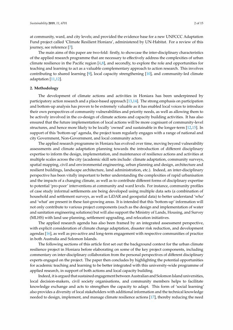
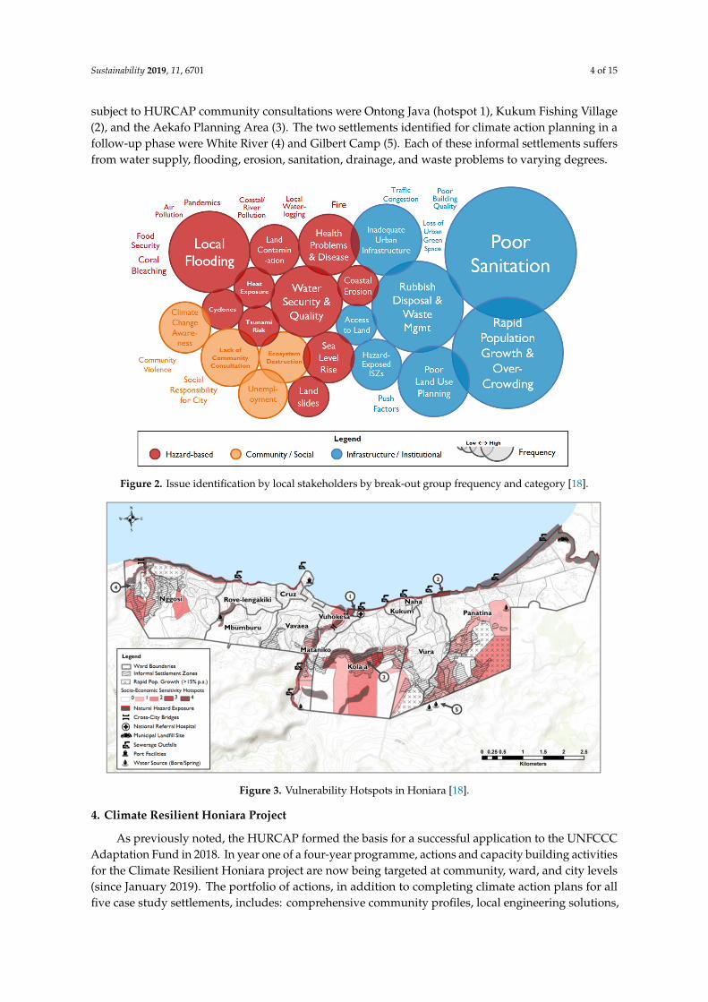
HURCAP activities involved close working with stakeholders to first identify local priorities at community, ward and city levels; and then to translate these into high-level objectives. These were then grouped and presented under 10 thematic category headings. At the community level, HURCAP focused its attention on three vulnerability ‘hotspot’ settlements that had been identified in the original vulnerability assessment [19]. However, it also recommended that another two areas also be profiled and assessed for climate vulnerabilities. As shown in Figure 3, the three settlements subject to HURCAP community consultations were Ontong Java (hotspot 1), Kukum Fishing Village (2), and the Aekafo Planning Area (3). The two settlements identified for climate action planning in a follow-
Figure 1. UN-Habitat climate change vulnerability assessments in the Pacific [18].
In the Honiara case, the 2014 vulnerability assessment was updated and extended by a secondphase of work, which led to the endorsement and publication of the Honiara Urban Resilience andClimate Action Plan (HURCAP) [18]. Whilst the original intention of this phase was to develop aclimate adaptation plan, it became evident during early stakeholder engagement processes that climatechange was only one of multiple stressors affecting local vulnerabilities (see Figure 2), and that explicitconsideration needed to be paid to current-day development issues and exposure to a range of naturalhazards, including earthquakes and tsunamis (due to the Solomon Islands being located in the Pacific‘Rim of Fire’).
Consequently, addressing immediate development needs was strongly reflected in the broaderurban resilience and climate action plan, which attempted to integrate climate adaptation, disaster riskreduction, and urban development goals. This integrated approach was based on the understanding thatthe implementation of urban resilience actions will not only reduce contemporary community exposureand sensitivity to multiple shocks and stresses, but will also result in a more solid socio-economicfoundation for longer-term climate change adaptation efforts.
HURCAP activities involved close working with stakeholders to first identify local prioritiesat community, ward and city levels; and then to translate these into high-level objectives. Thesewere then grouped and presented under 10 thematic category headings. At the community level,HURCAP focused its attention on three vulnerability ‘hotspot’ settlements that had been identifiedin the original vulnerability assessment [19]. However, it also recommended that another two areasalso be profiled and assessed for climate vulnerabilities. As shown in Figure 3, the three settlements
Sustainability 2019, 11, 6701 4 of 15
subject to HURCAP community consultations were Ontong Java (hotspot 1), Kukum Fishing Village(2), and the Aekafo Planning Area (3). The two settlements identified for climate action planning in afollow-up phase were White River (4) and Gilbert Camp (5). Each of these informal settlements suffersfrom water supply, flooding, erosion, sanitation, drainage, and waste problems to varying degrees.
Sustainability 2019, 11, x FOR PEER REVIEW 4 of 15
up phase were White River (4) and Gilbert Camp (5). Each of these informal settlements suffers from water supply, flooding, erosion, sanitation, drainage, and waste problems to varying degrees.
Figure 2. Issue identification by local stakeholders by break-out group frequency and category [18].
Figure 3. Vulnerability Hotspots in Honiara [18].
4. Climate Resilient Honiara Project
As previously noted, the HURCAP formed the basis for a successful application to the UNFCCC Adaptation Fund in 2018. In year one of a four-year programme, actions and capacity building activities for the Climate Resilient Honiara project are now being targeted at community, ward, and city levels (since January 2019). The portfolio of actions, in addition to completing climate action plans for all five case study settlements, includes: comprehensive community profiles, local engineering solutions, climate risk communication with women and youth groups, urban organic farming, climate resilient spaces (hard and soft), and recommendations for responsible land administration in peri-urban areas. Capacity strengthening efforts include: community awareness raising, ‘Planning
Figure 2. Issue identification by local stakeholders by break-out group frequency and category [18].
Sustainability 2019, 11, x FOR PEER REVIEW 4 of 15
up phase were White River (4) and Gilbert Camp (5). Each of these informal settlements suffers from water supply, flooding, erosion, sanitation, drainage, and waste problems to varying degrees.
Figure 2. Issue identification by local stakeholders by break-out group frequency and category [18].
Figure 3. Vulnerability Hotspots in Honiara [18].
4. Climate Resilient Honiara Project
As previously noted, the HURCAP formed the basis for a successful application to the UNFCCC Adaptation Fund in 2018. In year one of a four-year programme, actions and capacity building activities for the Climate Resilient Honiara project are now being targeted at community, ward, and city levels (since January 2019). The portfolio of actions, in addition to completing climate action plans for all five case study settlements, includes: comprehensive community profiles, local engineering solutions, climate risk communication with women and youth groups, urban organic farming, climate resilient spaces (hard and soft), and recommendations for responsible land administration in peri-urban areas. Capacity strengthening efforts include: community awareness raising, ‘Planning
Figure 3. Vulnerability Hotspots in Honiara [18].
4. Climate Resilient Honiara Project
As previously noted, the HURCAP formed the basis for a successful application to the UNFCCCAdaptation Fund in 2018. In year one of a four-year programme, actions and capacity building activitiesfor the Climate Resilient Honiara project are now being targeted at community, ward, and city levels(since January 2019). The portfolio of actions, in addition to completing climate action plans for allfive case study settlements, includes: comprehensive community profiles, local engineering solutions,

Sustainability 2019, 11, 6701 5 of 15
climate risk communication with women and youth groups, urban organic farming, climate resilientspaces (hard and soft), and recommendations for responsible land administration in peri-urban areas.Capacity strengthening efforts include: community awareness raising, ‘Planning for Climate Change’training with ward councilors, and the development of short professional training courses based onlocal needs. A selection of these project components is now expanded upon.
4.1. Community Profiles
A foundational component of the Climate Resilient Honiara project was to develop communityprofiles of settlements that are considered to be the most vulnerable to climate-related impacts. Whilethere are a number of ways to define a community profile, the project subscribes to the definitionby [20] (p. 6), whose work on profiling is seminal in development studies:
“A comprehensive description of the needs of a population that is defined, or defines itself, asa community, and the resources that exist within that community, carried out with the activeinvolvement of the community itself, for the purpose of developing an action plan or other meansof improving the quality of life of the community.”
Community profiles are commonly used to provide input to a broad range of actions and planningprocesses. For the Climate Resilient Honiara project, they provide the necessary detail at householdand settlement levels not only to inform climate resilience actions, but also to provide data to supportGovernment settlement upgrading and resettlement programmes (important in the context of rapidurbanisation and the growth of informal settlements). The aim was therefore to develop a survey thatcould be used as a reference point for subsequent work packages in the project (e.g., climate actionplans, community-level engineering interventions, open space and landscape design, urban organicagriculture, and responsible land administration). The community profiles will also serve as an inputto other awareness raising and capacity building activities.
The design of the survey was influenced by multiple factors: extant literature on climatevulnerability and urban resilience, existing datasets, previous surveys conducted nationally (around20 different relevant surveys were conducted between 2005 and 2018 either by Government or byNGOs), consideration of participant burden (given the numerous surveys previously conducted inHoniara, and how best to balance time vs. knowledge production), cultural sensitivities around certaintopics (such as land ownership), and the skill level of local surveyors and how they could be supportedby using innovative data collection platforms. Further considerations related to what types of datamight be collected and produced as part of the profiling exercise (it became apparent that multiplesocial-spatial relationships would need to be identified), and how profiling outputs might be useful toother stakeholders/projects in Solomon Islands.
The community profiling assessment aims to interact with every household within each targetedsettlement, rather than the more typical (and less resource-intensive) focus group approach, henceeliminating sampling issues [21]. It was also recognised that while the project used administrativeboundaries and zone names assigned by the MLHS to identify settlements, these do not always alignwith how resident communities self-identify as a ‘community’, and also that disparate communitiesmay co-exist within one settlement.
Site visits in early 2019 provided a means of directly engaging with communities in terms of localissues and needs; as well as with local government and non-government stakeholders who hold relevantdata or may be interested in the project’s outcomes. The design aspect of the survey also had to grapplewith the intrinsic intersectionality of climate change [22], especially with the types of knowledge thesurvey hoped to capture around social relations (e.g., gender, ethnicity, socio-economic status, etc.)and how this might translate to resources, vulnerability, and perceptions around decision-making andthe co-production of climate actions.
The community profiling survey was designed as a two-level exercise targeting both householdsand settlements.
Sustainability 2019, 11, 6701 6 of 15
4.1.1. Household-Level Survey
The household-level survey is comprised of seven categories of questions:
1. Household characteristics: describes the people who usually live in the household in terms of age,sex, ethnicity, language, religion, mobility, migration purpose, and duration of settlement.
2. Livelihood (economic and food) characteristics: describes the household’s food and economic securityconditions in terms of the ratio of working household members, sources of income, place of work,livestock, and fishing activity.
3. Housing characteristics: describes existing housing conditions including age of the house, floor area,improvements to house, number of rooms, floor material, and priorities for improving housing.
4. Utilities characteristics: describes the household’s access to services; including drinking watersource and quality, toilets, drainage, waste disposal, and power and water connections.
5. Land tenure characteristics: describes existing land tenure arrangements (as the householdunderstands it); including land owner identification, type of land use agreement, disputes,perception of tenure security, and whether the household has received an offer of a grant toconvert it into titled land.
6. Climate change and disaster preparedness characteristics: describes the household’s experience ofclimate-related hazards, disaster preparedness, and adaptation strategies.
7. Housing stock characteristics: visual survey of the condition of the housing stock including materialsused, condition of housing, height above ground, slope, water sources, toilets, and the nearestcommunal space.
4.1.2. Settlement-Level Survey
The settlement-level survey seeks to document the physical attributes that are important forvulnerability assessments such as accessibility and the physical assets associated with water resources,waste disposal, and community spaces (e.g., churches, schools, shops etc.). For the climate action plansand engineering interventions, it is useful to associate these characteristics with a location.
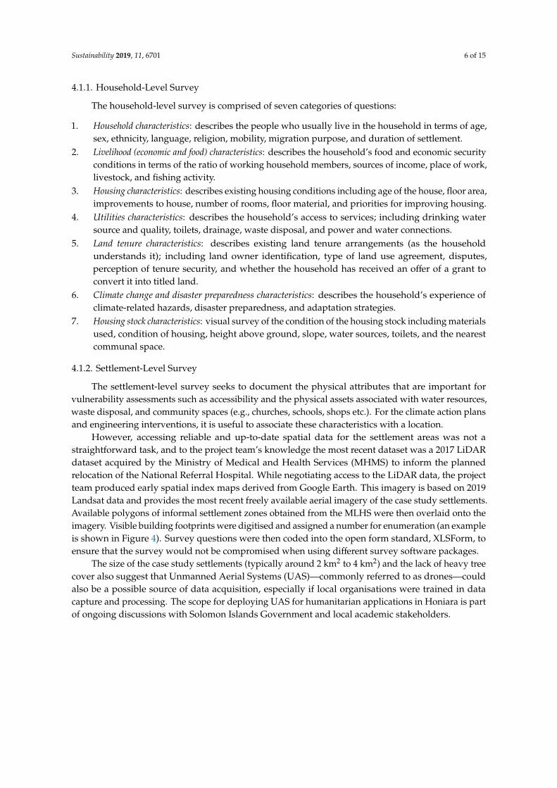
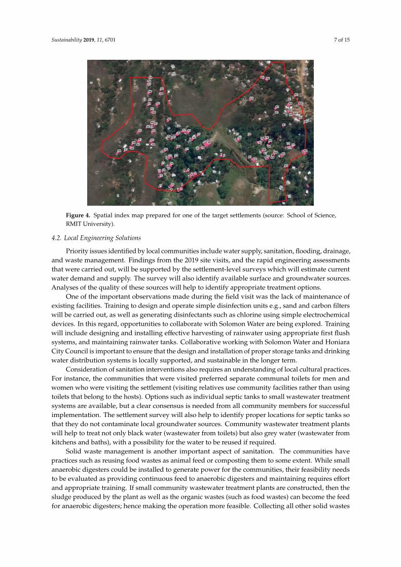
However, accessing reliable and up-to-date spatial data for the settlement areas was not astraightforward task, and to the project team’s knowledge the most recent dataset was a 2017 LiDARdataset acquired by the Ministry of Medical and Health Services (MHMS) to inform the plannedrelocation of the National Referral Hospital. While negotiating access to the LiDAR data, the projectteam produced early spatial index maps derived from Google Earth. This imagery is based on 2019Landsat data and provides the most recent freely available aerial imagery of the case study settlements.Available polygons of informal settlement zones obtained from the MLHS were then overlaid onto theimagery. Visible building footprints were digitised and assigned a number for enumeration (an exampleis shown in Figure 4). Survey questions were then coded into the open form standard, XLSForm, toensure that the survey would not be compromised when using different survey software packages.
The size of the case study settlements (typically around 2 km2 to 4 km2) and the lack of heavy treecover also suggest that Unmanned Aerial Systems (UAS)—commonly referred to as drones—couldalso be a possible source of data acquisition, especially if local organisations were trained in datacapture and processing. The scope for deploying UAS for humanitarian applications in Honiara is partof ongoing discussions with Solomon Islands Government and local academic stakeholders.
Sustainability 2019, 11, 6701 7 of 15
Sustainability 2019, 11, x FOR PEER REVIEW 7 of 15
Figure 4. Spatial index map prepared for one of the target settlements (source: School of Science, RMIT University).
4.2. Local Engineering Solutions
Priority issues identified by local communities include water supply, sanitation, flooding, drainage, and waste management. Findings from the 2019 site visits, and the rapid engineering assessments that were carried out, will be supported by the settlement-level surveys which will estimate current water demand and supply. The survey will also identify available surface and groundwater sources. Analyses of the quality of these sources will help to identify appropriate treatment options.
One of the important observations made during the field visit was the lack of maintenance of existing facilities. Training to design and operate simple disinfection units e.g., sand and carbon filters will be carried out, as well as generating disinfectants such as chlorine using simple electrochemical devices. In this regard, opportunities to collaborate with Solomon Water are being explored. Training will include designing and installing effective harvesting of rainwater using appropriate first flush systems, and maintaining rainwater tanks. Collaborative working with Solomon Water and Honiara City Council is important to ensure that the design and installation of proper storage tanks and drinking water distribution systems is locally supported, and sustainable in the longer term.
Consideration of sanitation interventions also requires an understanding of local cultural practices. For instance, the communities that were visited preferred separate communal toilets for men and women who were visiting the settlement (visiting relatives use community facilities rather than using toilets that belong to the hosts). Options such as individual septic tanks to small wastewater treatment systems are available, but a clear consensus is needed from all community members for successful implementation. The settlement survey will also help to identify proper locations for septic tanks so that they do not contaminate local groundwater sources. Community wastewater treatment plants will help to treat not only black water (wastewater from toilets) but also grey water (wastewater from kitchens and baths), with a possibility for the water to be reused if required.
Solid waste management is another important aspect of sanitation. The communities have practices such as reusing food wastes as animal feed or composting them to some extent. While small anaerobic digesters could be installed to generate power for the communities, their feasibility needs to be evaluated as providing continuous feed to anaerobic digesters and maintaining requires effort and appropriate training. If small community wastewater treatment plants are constructed, then the sludge produced by the plant as well as the organic wastes (such as food wastes) can become the feed for anaerobic digesters; hence making the operation more feasible. Collecting all other solid wastes
Figure 4. Spatial index map prepared for one of the target settlements (source: School of Science,RMIT University).
4.2. Local Engineering Solutions
Priority issues identified by local communities include water supply, sanitation, flooding, drainage,and waste management. Findings from the 2019 site visits, and the rapid engineering assessmentsthat were carried out, will be supported by the settlement-level surveys which will estimate currentwater demand and supply. The survey will also identify available surface and groundwater sources.Analyses of the quality of these sources will help to identify appropriate treatment options.
One of the important observations made during the field visit was the lack of maintenance ofexisting facilities. Training to design and operate simple disinfection units e.g., sand and carbon filterswill be carried out, as well as generating disinfectants such as chlorine using simple electrochemicaldevices. In this regard, opportunities to collaborate with Solomon Water are being explored. Trainingwill include designing and installing effective harvesting of rainwater using appropriate first flushsystems, and maintaining rainwater tanks. Collaborative working with Solomon Water and HoniaraCity Council is important to ensure that the design and installation of proper storage tanks and drinkingwater distribution systems is locally supported, and sustainable in the longer term.
Consideration of sanitation interventions also requires an understanding of local cultural practices.For instance, the communities that were visited preferred separate communal toilets for men andwomen who were visiting the settlement (visiting relatives use community facilities rather than usingtoilets that belong to the hosts). Options such as individual septic tanks to small wastewater treatmentsystems are available, but a clear consensus is needed from all community members for successfulimplementation. The settlement survey will also help to identify proper locations for septic tanks sothat they do not contaminate local groundwater sources. Community wastewater treatment plantswill help to treat not only black water (wastewater from toilets) but also grey water (wastewater fromkitchens and baths), with a possibility for the water to be reused if required.
Solid waste management is another important aspect of sanitation. The communities havepractices such as reusing food wastes as animal feed or composting them to some extent. While smallanaerobic digesters could be installed to generate power for the communities, their feasibility needsto be evaluated as providing continuous feed to anaerobic digesters and maintaining requires effortand appropriate training. If small community wastewater treatment plants are constructed, then thesludge produced by the plant as well as the organic wastes (such as food wastes) can become the feedfor anaerobic digesters; hence making the operation more feasible. Collecting all other solid wastes
Sustainability 2019, 11, 6701 8 of 15
and either recycling them or disposing in landfills should be an immediate action to protect streamsand coastal waters.
Stormwater management (SWM) can help to prevent flooding and provide safety to the coastalcommunities as well as those living in downstream areas. Appropriate SWM will help to attenuatepeak flows as well as delay its arrival downstream, thereby allowing communities to prepare orevacuate. For instance, Ontong Java has a new flood warning system which will help to evaluate theeffectiveness of existing SWM systems. However, the dumping of solid wastes in rivers and streams(as is common in inland locations) exaggerates erosion and leads to greater movement of sediments,the blocking of stormwater canals, and a decrease in hydraulic capacity. Developing appropriatepools and ripples, as well as retention ponds, would therefore contribute to improved SWM. Propercollection systems that drain the stormwater from the communities should also be considered.
Implementation of engineering actions in 2020, targeting WASH, waste management, drainageand flooding, will be undertaken in collaboration with the Solomon Islands National University (SINU),relevant local NGOs, and members of local communities.
4.3. Climate Resilient Buildings
The site visits in February 2019 were also attended by university staff with backgrounds inarchitecture, building design, and civil engineering. For the two coastal settlements (Ontong Javaand Kukum Fishing Village) overcrowding was found to be a major issue, with the blocking ofcooling sea breezes leading to increased heat in the settlements. The spatial layout of houses thereforeneeds to be reconsidered with a greater account of passive housing principles i.e., the promotion ofcross-ventilation so that occupants are better able to take advantage of prevailing breezes. Some of theproblems associated with overcrowding could potentially be overcome by increasing density vertically.At the moment, most houses rest on stilts with daytime activities taking place under the house; thecoolest area during daytime hours. It therefore makes sense to build houses with the living areas andkitchens on the lower levels and the sleeping areas upstairs. Other considerations include the factthat most houses were single rooms with kitchens typically outside the house, toilets and bathroomswere either communal or did not exist at all, and some of the houses had separate sleeping areas formale teenagers.
Another disadvantage of having the houses so close to each other is that this poses a fire risk.Since the kitchens use open fires with sawdust or wood (or other fuels such as kerosene), it wouldbe difficult to put out any fires once they had started. Therefore, kitchens need to be designed withmaterials that can either be isolated or else have the ability to contain the outbreak of fires. Kitchensare typically not part of the living space, so culturally such options may be locally acceptable.
Care also needs to be taken when specifying housing materials so that inappropriate materialssuch as metal sheeting are not used (this stores and radiates heat, leading to very high interiortemperatures when compared to outdoor temperatures). Materials used for buildings in all thesettlements are largely scrap, so in some respects they are—by necessity—reusing materials (andtherefore embracing circularity principles to some extent). However, most scrap materials are notreliable as wall, roofing, or floor materials because they do not provide the necessary material strength.One alternative consideration would be to assess the feasibility of other reused materials for construction(e.g., conversion of plastics to useful materials, given that all Pacific nations have a problem withplastic waste).
Best practice guidelines for resilient housing are to be derived in consultation with local experts.This will involve an analysis of traditional housing, materials, and construction techniques; as well asdiscussions with government officials to better understand the future availability of building materials.Building codes and regulations will also need to be considered (building codes are currently plannedbut have not yet passed as legislation). The intention is to assess existing housing typologies totailor existing designs for resilience, hence retaining indigenous knowledge while at the same timemaking housing more adaptable and resilient. Future action will design and construct model houses
Sustainability 2019, 11, 6701 9 of 15
as examples that demonstrate appropriate material use, siting and placement, and use of appropriateconstruction techniques. Local experts, e.g., SINU academics and vocational students, will be involvedwith the development of the guidelines and demonstration projects.
The housing guidelines will also be transferable to a model evacuation centre; albeit at a biggerscale (the use of materials, site access, orientation, and other such basic design principles will notchange). Involving community members in the planning and development of evacuation centres willhelp to promote local ownership of the centre and help to ensure ongoing maintenance. For the project,research is currently underway to determine the locations where evacuation centres are most needed,the use of appropriate materials, and techniques for planning, design, and construction of a pilotevacuation centre. This provides a good example of inter-disciplinary working within the project, withGIS, hazard, and spatial planning experts informing the location of evacuation centres to be designedby architects and engineers. The geospatial maps will also assist with master planning settlementsaway from high risk areas and support a phased approach to new construction in Honiara over time.
For communities that are already struggling to address a range of issues with limited time andbudgets, one approach would be to consider which existing structures could be used for multiplefunctions, and to use this as the initial pilot. For example, in Aekefo Informal Settlement, the existingchurch also doubles up as a community centre and could be further adapted to act as an evacuationcentre during extreme events. The functional requirements for this existing structure will be informedby a needs assessment of what the community requires in an evacuation centre. For instance, thestructure not only needs to be cyclone resistant, provide protection from inclement weather, enableeasy access for residents, to be large enough to accommodate the numbers of people to be evacuated,and provide basic sanitation facilities, but also needs to account for the privacy and safety of women.
Moving forward, implementation partners will include the Ministry of Environment, ClimateChange, and Disaster Management (MECCDM), SINU, Honiara City Council (in particular WardCouncilors), and members of local communities.
4.4. Nature-Based Solutions
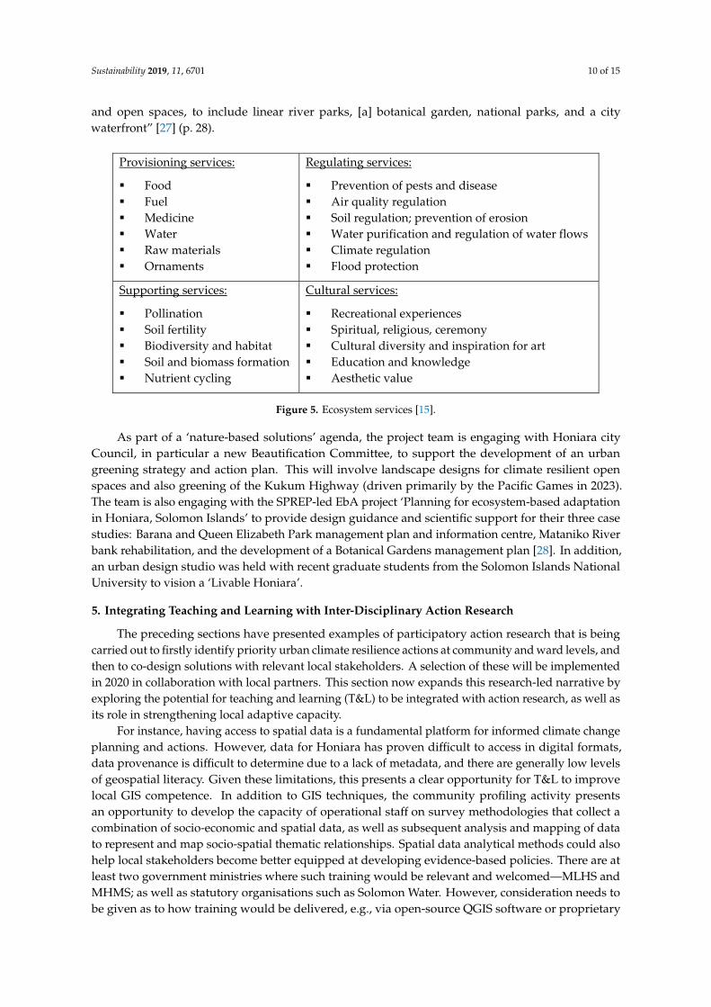
Natural ecosystems, and the services they provide, are extremely important for human wellbeing.They not only provide us with the food, water, and raw materials to meet our basic needs, but theyalso contribute broader societal benefits such as preventing erosion, providing protection from floods,regulating local climates, ensuring the continued health of soils, sustaining cultural sense of place,etc. These multitude of benefits are known collectively as ecosystem services (see Figure 5) andprovide the basis for community resilience and well-being through a range of provisioning, regulating,cultural and supporting services [23]. More recently, the International Union for Conservationof Nature defined nature-based solutions as actions to protect, sustainably manage, and restorenatural or modified ecosystems, which address societal challenges effectively and adaptively, whilesimultaneously providing human well-being and biodiversity benefits [24].
Ecosystem services are particularly important to the people of the South Pacific, who continueto rely overwhelmingly on resources from the land and sea for subsistence food and cash income; aswell as for social and cultural value [25]. Furthermore, nature-based solutions can play an importantrole in enhancing local climate resilience through cost-effective actions. Such options are commonlyreferred to as ‘ecosystem-based adaptation’ (EbA) [26]. However, rapid urbanisation, the informalgrowth of settlements, and the constraints imposed by the municipal boundary means that there isever-increasing pressure on existing open space in Honiara’s urban and peri-urban environments; withmuch of the remaining space also being in poor condition.
To support local EbA efforts, an academic team of landscape architects, designers, and urbangreening experts visited the city to support Honiara City Council with their urban greening efforts. Thisengagement took place in the context of the recently published Greater Honiara Urban DevelopmentStrategy and Action Plan which sets out a Masterplan goal to establish a “network of green
Sustainability 2019, 11, 6701 10 of 15
and open spaces, to include linear river parks, [a] botanical garden, national parks, and a citywaterfront” [27] (p. 28).Sustainability 2019, 11, x FOR PEER REVIEW 10 of 15
Provisioning services:
Food Fuel Medicine Water Raw materials Ornaments
Regulating services:
Prevention of pests and disease Air quality regulation Soil regulation; prevention of erosion Water purification and regulation of water flows Climate regulation Flood protection
Supporting services:
Pollination Soil fertility Biodiversity and habitat Soil and biomass formation Nutrient cycling
Cultural services:
Recreational experiences Spiritual, religious, ceremony Cultural diversity and inspiration for art Education and knowledge Aesthetic value
Figure 5. Ecosystem services [15].
As part of a ‘nature-based solutions’ agenda, the project team is engaging with Honiara city Council, in particular a new Beautification Committee, to support the development of an urban greening strategy and action plan. This will involve landscape designs for climate resilient open spaces and also greening of the Kukum Highway (driven primarily by the Pacific Games in 2023). The team is also engaging with the SPREP-led EbA project ‘Planning for ecosystem-based adaptation in Honiara, Solomon Islands’ to provide design guidance and scientific support for their three case studies: Barana and Queen Elizabeth Park management plan and information centre, Mataniko River bank rehabilitation, and the development of a Botanical Gardens management plan [28]. In addition, an urban design studio was held with recent graduate students from the Solomon Islands National University to vision a ‘Livable Honiara’.
5. Integrating Teaching and Learning with Inter-Disciplinary Action Research
The preceding sections have presented examples of participatory action research that is being carried out to firstly identify priority urban climate resilience actions at community and ward levels, and then to co-design solutions with relevant local stakeholders. A selection of these will be implemented in 2020 in collaboration with local partners. This section now expands this research-led narrative by exploring the potential for teaching and learning (T&L) to be integrated with action research, as well as its role in strengthening local adaptive capacity.
For instance, having access to spatial data is a fundamental platform for informed climate change planning and actions. However, data for Honiara has proven difficult to access in digital formats, data provenance is difficult to determine due to a lack of metadata, and there are generally low levels of geospatial literacy. Given these limitations, this presents a clear opportunity for T&L to improve local GIS competence. In addition to GIS techniques, the community profiling activity presents an opportunity to develop the capacity of operational staff on survey methodologies that collect a combination of socio-economic and spatial data, as well as subsequent analysis and mapping of data to represent and map socio-spatial thematic relationships. Spatial data analytical methods could also help local stakeholders become better equipped at developing evidence-based policies. There are at least two government ministries where such training would be relevant and welcomed—MLHS and MHMS; as well as statutory organisations such as Solomon Water. However, consideration needs to be given as to how training would be delivered, e.g., via open-source QGIS software or proprietary software like MapInfo Pro (which is used by MLHS), as ongoing licensing fees might be a barrier to mainstreaming these skills.
If the project deploys UAS as a data capture mechanism, this would present further opportunities for introducing T&L components; including the design and development of both hardware and software that is fit-for-purpose in climate-related urban surveillance. The challenge
Figure 5. Ecosystem services [15].
As part of a ‘nature-based solutions’ agenda, the project team is engaging with Honiara cityCouncil, in particular a new Beautification Committee, to support the development of an urbangreening strategy and action plan. This will involve landscape designs for climate resilient openspaces and also greening of the Kukum Highway (driven primarily by the Pacific Games in 2023).The team is also engaging with the SPREP-led EbA project ‘Planning for ecosystem-based adaptationin Honiara, Solomon Islands’ to provide design guidance and scientific support for their three casestudies: Barana and Queen Elizabeth Park management plan and information centre, Mataniko Riverbank rehabilitation, and the development of a Botanical Gardens management plan [28]. In addition,an urban design studio was held with recent graduate students from the Solomon Islands NationalUniversity to vision a ‘Livable Honiara’.
5. Integrating Teaching and Learning with Inter-Disciplinary Action Research
The preceding sections have presented examples of participatory action research that is beingcarried out to firstly identify priority urban climate resilience actions at community and ward levels, andthen to co-design solutions with relevant local stakeholders. A selection of these will be implementedin 2020 in collaboration with local partners. This section now expands this research-led narrative byexploring the potential for teaching and learning (T&L) to be integrated with action research, as well asits role in strengthening local adaptive capacity.
For instance, having access to spatial data is a fundamental platform for informed climate changeplanning and actions. However, data for Honiara has proven difficult to access in digital formats,data provenance is difficult to determine due to a lack of metadata, and there are generally low levelsof geospatial literacy. Given these limitations, this presents a clear opportunity for T&L to improvelocal GIS competence. In addition to GIS techniques, the community profiling activity presentsan opportunity to develop the capacity of operational staff on survey methodologies that collect acombination of socio-economic and spatial data, as well as subsequent analysis and mapping of datato represent and map socio-spatial thematic relationships. Spatial data analytical methods could alsohelp local stakeholders become better equipped at developing evidence-based policies. There are atleast two government ministries where such training would be relevant and welcomed—MLHS andMHMS; as well as statutory organisations such as Solomon Water. However, consideration needs tobe given as to how training would be delivered, e.g., via open-source QGIS software or proprietary

Sustainability 2019, 11, 6701 11 of 15
software like MapInfo Pro (which is used by MLHS), as ongoing licensing fees might be a barrier tomainstreaming these skills.
If the project deploys UAS as a data capture mechanism, this would present further opportunitiesfor introducing T&L components; including the design and development of both hardware andsoftware that is fit-for-purpose in climate-related urban surveillance. The challenge would be to assesshow this might intersect with local capacity (e.g., with the surveying profession) who might alreadyutilise UAS and may prefer targeted short courses (e.g., UAS for land administration). There are alsoopportunities to work with SINU to develop UAS-related teaching materials that complement theirexisting surveying curriculum.
Many of the challenges facing vulnerable and marginalised communities, including those ininformal settlements in Honiara, are often inter-related and complex to solve. Urban planners anddesigners need to collaborate with engineers to incorporate appropriate engineering and technologydesigns into local decision-making processes. The Climate Resilient Honiara project emphasises theimportance of co-designing solutions and therefore the need for introductory engineering capacitybuilding of local stakeholders in key themes. The project’s engineering contingent proposed thatacademics compile training modules on essential topics such as designing, maintaining and operatingtimber bridges, rain water harvesting systems, water treatment units, water storage tanks, septic tanks,small wastewater treatment systems, anaerobic digesters, solid waste recycling systems, and landfills.Additionally, modules on environmental science such as water quality analyses and groundwatermanagement will enable Honiara to improve the water quality from the catchment to the tap. Basicengineering knowledge will empower communities to take ownership of resilience actions, whileworking with relevant authorities. It will also allow community members to not only participate in thedesign and development of various projects but also to be employed in the implementation phase.The capacities that are built in engineering and environmental science will, over time, also provideopportunities for developing more substantive interventions in the longer term e.g., integrated watermanagement initiatives.
The project is assessing the existing land administration system, and the complexity of landtenure issues that might affect the implementation of climate resilience actions. This assessmentincludes research into the capacity of the MLHS and the surveying education institutions, the geodeticnetwork, as well as existing approaches to land administration (e.g., the process of upgrading fromTemporary Occupation Licenses to Fixed Term Estate titles). As part of this evaluation process, there isan opportunity to engage with the Surveying Department of the SINU was identified (they offer aland surveying diploma). After a joint meeting in February 2019 to discuss their capacity developmentneeds, and scope opportunities for student-led activity, one of the outcomes was a desire for localsurveying students to be involved with the implementation of actions in the field. To support this, anew Memorandum of Understanding between SINU and RMIT University has been signed to promote:(i) the exchange of faculty and staff members, (ii) research collaboration, (iii) participation in seminarsand academic meetings, (iv) exchange of academic materials and other information, (iv) capacitydevelopment of SINU staff, and (v) potential student mobility opportunities. In more immediate terms,youth are being involved in household and settlement survey activities, and further support for SINUthrough educational resources and course development will be explored in 2020.
To further promote T&L contributions to the project, a short training workshop will be held atSINU in early 2020 to carry out training in GIS risk mapping, urban planning, and land administration.These are skill sets that will contribute to more effective and strategic urban resilience planning forthe city. Given the low levels of capacity at SINU at present, the workshop will reach beyond theuniversity and also include MLHS and Honiara City Council (HCC) professional staff (SINU is a younguniversity, having been opened in 2013. Prior to 2013, most of the training needs in the country weremet by training institutions offering vocational education. SINU now has five main schools, reflectingthe programs offered by the university: the School of Education and Humanities, School of Natural
Sustainability 2019, 11, 6701 12 of 15
Resources and Applied Sciences, School of Nursing and Allied Health Sciences, School of Business andManagement and the School of Technology and Maritime Studies).
Other areas of alignment between the two universities are the programs for building andconstruction which are part of the School of Technology and Maritime Studies (STMS) in the Institute ofTechnology. The Institute of Technology (ITech) offers trade courses in carpentry and joinery, plumbingand allied trades, electrical, mechanical, marine engineering, and surveying and drafting. From abuildings and construction perspective, design, planning and use of materials and ongoing maintenanceare all critical. Some of the potential areas for collaboration involve design and construction elements,scenario planning, use of appropriate materials, and future proofing for extreme events. However, theSINU courses are offered at vocational levels only (Certificate, Advanced Certificate, and Diplomalevels) and there are no Bachelor-level programs. This has implications for the development andimplementation of the national building code, as well as local capacities for planning and buildingmore generally. Furthermore, SINU is self-accredited and this limitation will need to be addressed forprofessional degrees such as construction management.
Knowledge exchange and mutual learning is also possible through potential joint student activitiesin Honiara’s informal settlements. This will be facilitated through site visits involving a group ofstudents from the engineering, planning, and construction management disciplines at RMIT University,in collaboration with local students and NGOs (to support this, students will be supported throughNew Columbo Plan funding). This would enable the integration of local knowledge and scientific bestpractice to derive the best practical housing and settlement infrastructure outcomes for the urban poor,as well as providing students the opportunity to productively engage with a ‘living laboratory’. Suchapplied experience will allow students to better understand the multi-disciplinary expertise that isneeded to address the breadth and depth of challenges in vulnerability hotspot settlements, as well asencouraging cross-cultural learning. T&L can also have a role to play when engaging more broadlywith women and youth groups in the city.
The project team are also collaborating with ICLEI—Local Governments for Sustainability andhave jointly facilitate training on disaster risk reduction (DRR) and climate change adaptation (CCA)with newly elected Ward Councilors. The CCA training draws from the UN-Habitat Planning forClimate Change guidelines and the activities are designed to help to strengthen the adaptive capacityof the Councilors, and by extension the local communities they represent.
Finally, a key city-level deliverable for the Climate Resilient Honiara project is the development ofa short professional course that is to be designed to address the needs of Solomon Island Governmentstaff, to be held in Melbourne. Attendees will be drawn from key Ministries such as MLHS, MECCDM,and MHMS, as well as officials from HCC. This will be a direct opportunity for lecturing staff
based in Melbourne to engage with Solomon Island Government officials and provide training thatfurther contributes to capacity strengthening; ultimately leading to more informed urban policies andmanagement practice. The course will be designed based on local needs that are identified duringmultiple field visits, but is likely to include elements of urban planning and design, land administration,GIS, climate resilient buildings, nature-based solutions, basic engineering, etc.
6. Conclusions
Addressing the myriad of real-world problems faced by the urban poor in fast-growing citiesin the Pacific is a challenging task. Future climate change will act to amplify many of the problemsthat they already face. As has been highlighted in this paper based on Honiara, efforts at equitableclimate resilient urban development benefit not only from an inter-disciplinary approach but also onethat is founded on new ways of cooperation between academics, Government organisations, statutorybodies, NGOs, and a wide range of local stakeholders. Trust and commitment to collaborative workingbetween the various actors involved is needed. However, these are traits that need to be establishedand built on over a period of time, emphasising the value of long-term engagement and the creation ofspaces for mutual learning (project team members have been working in Honiara since 2014).
Sustainability 2019, 11, 6701 13 of 15
Whilst still in the first year of a four-year programme, the Climate Resilient Honiara projectshowcases the potential for participatory and inter-disciplinary research to directly support theco-design and implementation of resilience actions at the community and ward levels (these willcommence in year 2 of the project). Furthermore, as the research activity across project componentsprogresses, this will open up new opportunities for T&L to further contribute to local capacitystrengthening. Indeed, T&L has a pivotal role to play in supporting the development of local urbanplans and actions, given the weak formal governance institutions that exist at the city-scale.
The signing of an MoU between RMIT University and SINU is a valuable first step in encouragingcollaboration and learning between two academic organisations in Australia and the Pacific. As wellas encouraging staff and student involvement with local project actions, RMIT University will supportcourse development for diplomas that align with SINU’s existing areas of expertise e.g., land surveyingand construction management. Moving forward, the MLHS has also expressed its intent to establish anational planning association, and asked SINU to contribute to this agenda by developing and runninga new diploma in urban planning with support from RMIT University. Again, this is an opportunityfor cross-organisational partnership working between Australia and Solomon Islands. In addition toacademic collaboration, two other direct project actions are the training and capacity building activitieswith Solomon Island Government officials (improving GIS skills has been identified as a priority)and Ward Councilors at the sub-city level (disaster risk reduction, climate resilience planning, andinvolvement with the location and design of evacuation centres).
Whilst the primary focus of the project is on delivering outcomes for informal settlements inHoniara (actions and capacity strengthening) it would be dismissive to ignore the impact of two-wayknowledge sharing and the benefits this brings to staff at RMIT University. Taking engineering as anexample, in the forward to the iconic 2010 report ‘Engineering: Issues Challenges and Opportunities forDevelopment’ the Director-General of UNESCO, Irina Bokova, stated: “Now and in the years to come,we need to ensure that motivated young women and men concerned about problems in the developingworld continue to enter the field in sufficient numbers”. As engineering is an industry that requirestertiary education recognised by professional associations to practice in Australia, it is the responsibilityof universities to appropriately prepare students for their roles and responsibilities when applyingengineering knowledge and technology. This in turn requires academics to understand the issuesfacing the Global South, and to be able to account for this in course teaching material and curricula.
What is clear from the Climate Resilient Honiara project experience to date is that Australianuniversity partnerships with our Pacific Island neighbours, in a development space that has traditionallybeen the preserve of consultancies, have the potential to bring multiple benefits to both sides. Long-termengagement through such projects allows trust to be built with local stakeholders, actions to beco-designed with technical support from the university (integrated with local traditional knowledge),the necessary local networks to be formed that support, implement, and maintain resilience actions,and enable knowledge sharing and training that strengthens local capacity to respond to current andfuture urban resilience challenges.
Author Contributions: Writing—original draft, D.M., U.I.-R., S.H., D.M., V.J. and N.B.
Funding: UNFCCC Adaptation Fund, administered by UN-Habitat.
Conflicts of Interest: The authors declare no conflict of interest.
References
1. Parnell, S.; Simon, D.; Vogel, C. Global environmental change: Conceptualising the growing challenge forcities in poor countries. Area 2007, 39, 357–369. [CrossRef]
2. Carmin, J.; Anguelovski, I.; Roberts, D. Urban Climate Adaptation in the Global South: Planning in anEmerging Policy Domain. J. Plan. Educ. Res. 2012, 32, 18–32. [CrossRef]
3. Friend, R.; Jarvie, J.; Reed, S.O.; Sutarto, R.; Thinphanga, P.; Toan, V.C. Mainstreaming urban climate resilienceinto policy and planning: Reflections from Asia. Urban Clim. 2014, 7, 6–19. [CrossRef]
Sustainability 2019, 11, 6701 14 of 15
4. Kiddle, G.; McEvoy, D.; Mitchell, D.; Jones, P.; Mecartney, S. Unpacking the Pacific urban agenda: Resiliencechallenges and opportunities. Sustainability 2017, 9, 1878. [CrossRef]
5. McEvoy, D.; Mitchell, D.; Trundle, A. Land tenure and urban climate resilience in the South Pacific. Clim. Dev.2019, 1–11. [CrossRef]
6. UN-Habitat; EcoPlan International. Planning for Climate Change—A Strategic, Values-Based Approach for UrbanPlanners; UN-Habitat: Nairobi, Kenya, 2014.
7. McEvoy, D.; Barth, B.; Trundle, A.; Mitchell, D. Reflecting on a journey from climate change vulnerabilityassessments to the implementation of climate resilience actions: Honiara, Solomon Islands. In UrbanResilience in the Asia Pacific: Challenges and Opportunities for Addressing Disasters and Climate Change in the BuiltEnvironment; Routledge; forthcoming.
8. Butcher-Gollach, C. Planning and Urban Informality—Addressing Inclusiveness for Climate Resiliencein the Pacific. In Climate Change Impacts and Adaptation Strategies for Coastal Communities. Climate ChangeManagement; Leal Filho, W., Ed.; Springer: Cham, Germany, 2018.
9. Tyler, S.; Moench, M. A framework for urban climate resilience. Clim. Dev. 2012, 4, 311–326. [CrossRef]10. Warrick, O.; Aalbersberg, W.; Dumaru, P.; McNaught, R.; Teperman, K. The ’Pacific Adaptive Capacity
Analysis Framework’: Guiding the assessment of adaptive capacity in Pacific island communities.Reg. Environ. Chang. 2017, 17, 1039. [CrossRef]
11. Forsyth. Community-based adaptation: A review of past and future challenges. Wires Clim. Chang. 2013, 4,439–446. [CrossRef]
12. Clarke, T.; McNamara, K.E.; Clissold, R.; Nunn, P.D. Community-based adaptation to climate change:Lessons from Tanna Island, Vanuatu. Isl. Stud. J. 2019, 14, 59–80. [CrossRef]
13. Kelman, I.; Lewis, J.; Gaillard, J.C.; Mercer, J. Participatory Action Research for Dealing with Disasters onIslands. Isl. Stud. J. 2011, 6, 59–86.
14. Henly-Shepard, S.; Anderson, C.; Burnett, K.; Cox, L.J.; Kittinger, J.N.; Ka‘aumoana, M. Quantifyinghousehold social resilience: A place-based approach in a rapidly transforming community. Nat. Hazards2015, 75, 343–363. [CrossRef]
15. Trundle, A.; Barth, B.; McEvoy, D. Leveraging endogenous climate resilience: Urban adaptation in PacificSmall Island Developing States. Environ. Urban. 2019, 31, 53–74. [CrossRef]
16. Birkmann, J.; von Teichman, K. Integrating disaster risk reduction and climate change adaptation: Keychallenges—Scales, knowledge, and norms. Sustain. Sci. 2010, 5, 171–184. [CrossRef]
17. Ensor, J.; Harvey, B. Social learning and climate change adaptation: Evidence for international developmentpractice. Wires Clim. Chang. 2015, 6, 509–522. [CrossRef]
18. Trundle, A.; McEvoy, D. Honiara Urban Resilience and Climate Action Plan; Report for UN-Habitat: Fukuoka,Japan, 2016.
19. UN-Habitat. Climate Change Vulnerability Assessment, Honiara, Solomon Islands; UN-Habitat: Nairobi, Kenya,2014.
20. Hawtin, M.; Percy-Smith, J. Community Profiling: A Practical Guide, 2nd ed.; Open UniversityPress/McGraw-Hill Education: London, UK, 2007.
21. Blackshaw, T.; Woodhouse, D. Community profiling. In SAGE Key Concepts Series: Key Concepts in CommunityStudies; London, UK, 2010; pp. 55–60. [CrossRef]
22. Kaijser, A.; Kronsell, A. Climate change through the lens of intersectionality. Environ. Politics 2014, 23,417–433. [CrossRef]
23. Millennium Ecosystem Assessment. Ecosystems and Human Well-Being: Synthesis; Island Press: Washington,DC, USA, 2005.
24. Cohen-Shacham, E.; Walters, G.; Janzen, C.; Maginnis, S. (Eds.) Nature-Based Solutions to Address GlobalSocietal Challenges; IUCN: Gland, Switzerland, 2016.
25. McEvoy, D.; de Ville, N.; Komugabe-Dixson, A.; Trundle, A. Greater Port Vila. Social Mapping andAnalysis of Ecosystem Use; Report for SPREP, Samoa; 2017. Available online: https://www.researchgate.net/publication/328529260_Greater_Port_Vila_Social_Mapping_and_Analysis_of_Ecosystem_Use (accessed on14 August 2019).
26. Colls, A.; Ash, N.; Ikkala, N. Ecosystem-Based Adaptation: A Natural Response to Climate Change; IUCN: Gland,Switzerland, 2009.

Sustainability 2019, 11, 6701 15 of 15
27. MLHS; ADB. Greater Honiara Urban Development Strategy and Action Plan (Volume I); Solomon Islands Ministryof Lands, Housing and Survey, 2018.
28. SPREP. Planning for Ecosystem-Based Adaptation in Honiara, Solomon Islands; A Synthesis Report; The Secretariatof the Pacific Regional Environment Programme: Apia, Samoa, 2018.
© 2019 by the authors. Licensee MDPI, Basel, Switzerland. This article is an open accessarticle distributed under the terms and conditions of the Creative Commons Attribution(CC BY) license (http://creativecommons.org/licenses/by/4.0/).