intelligent transportation systems - home -...
TRANSCRIPT

Intelligent Transportation
Systems
Technical Report Summary
1
Background
What is an Intelligent Transportation System?
An Intelligent Transportation System (ITS) improves transportation safety and
mobility and enhances productivity through the use of advanced
communications technologies. It encompasses a broad range of wireless and
wire line communications-based information and electronic technologies.
When integrated into the transportation system's infrastructure, and in vehicles
themselves, these technologies relieve congestion, improve safety and
enhance American productivity. The system is made up of 16 types of
technology based systems. These systems (application areas) are divided into
intelligent infrastructure systems and intelligent vehicle systems.
Intelligent Infrastructure
Arterial Management
Freeway Management
Transit Management
Traffic Incident Management
Emergency Management
Electronic Payment and
Pricing
Traveler Information
Information Management
Crash Prevention and Safety
Roadway Operations and
Maintenance
Road Weather Management
Commercial Vehicle
Operations
Intermodal Freight
Intelligent Vehicles
Collision Avoidance Systems
Driver Assistance Systems
Collision Notification Systems
Definitions
The following application area definitions were obtained from the Intelligent
Transportation Systems Joint Program Office website, located within the U.S.
Department of Transportation Research and Innovative Technology
Administration. The definitions provide a brief overview of the 16 types of
technology based systems.
Arterial Management
Arterial management systems manage traffic along arterial roadways,
employing traffic detectors, traffic signals, and various means of communicating
2
information to travelers. These systems make use of information collected by
traffic surveillance devices to smooth the flow of traffic along travel corridors.
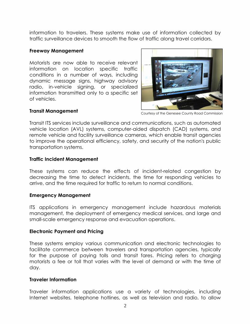
Freeway Management
Motorists are now able to receive relevant
information on location specific traffic
conditions in a number of ways, including
dynamic message signs, highway advisory
radio, in-vehicle signing, or specialized
information transmitted only to a specific set
of vehicles.
Transit Management
Transit ITS services include surveillance and communications, such as automated
vehicle location (AVL) systems, computer-aided dispatch (CAD) systems, and
remote vehicle and facility surveillance cameras, which enable transit agencies
to improve the operational efficiency, safety, and security of the nation's public
transportation systems.
Traffic Incident Management
These systems can reduce the effects of incident-related congestion by
decreasing the time to detect incidents, the time for responding vehicles to
arrive, and the time required for traffic to return to normal conditions.
Emergency Management
ITS applications in emergency management include hazardous materials
management, the deployment of emergency medical services, and large and
small-scale emergency response and evacuation operations.
Electronic Payment and Pricing
These systems employ various communication and electronic technologies to
facilitate commerce between travelers and transportation agencies, typically
for the purpose of paying tolls and transit fares. Pricing refers to charging
motorists a fee or toll that varies with the level of demand or with the time of
day.
Traveler Information
Traveler information applications use a variety of technologies, including
Internet websites, telephone hotlines, as well as television and radio, to allow
Courtesy of the Genesee County Road Commission
3
users to make more informed decisions regarding trip departures, routes, and
mode of travel.
Information Management
ITS information management supports the archiving and retrieval of data
generated by other ITS applications and enables ITS applications that use
archived information. Decision support systems, predictive information, and
performance monitoring are some ITS applications enabled by ITS information
management. In addition, ITS information management systems can assist in
transportation planning, research, and safety management activities.
Crash Prevention and Safety
Crash prevention and safety systems detect unsafe conditions and provide
warnings to travelers to take action to avoid crashes. These systems provide
alerts for traffic approaching at dangerous curves, off ramps, restricted
overpasses, highway-rail crossings, high-volume intersections, and also provide
warnings of the presence of pedestrians, and bicyclists, and even animals on
the roadway.
Roadway Operations and Maintenance
ITS applications in operations and maintenance focus on integrated
management of maintenance fleets, specialized service vehicles, hazardous
road conditions remediation, and work zone mobility and safety. These
applications monitor, analyze, and disseminate roadway and infrastructure data
for operational, maintenance, and managerial uses. ITS can help secure the
safety of workers and travelers in a work zone while facilitating traffic flow
through and around the construction area.
Road Weather Management
Road weather management activities include road weather information
systems (RWIS), winter maintenance technologies, and coordination of
operations within and between state DOTs. ITS applications assist with the
monitoring and forecasting of roadway and atmospheric conditions,
dissemination of weather-related information to travelers, weather-related traffic
control measures such as variable speed limits, and both fixed and mobile
winter maintenance activities.
Commercial Vehicle Operations
ITS applications for commercial vehicle operations are designed to enhance
communication between motor carriers and regulatory agencies. Examples
4
include electronic registration and permitting programs, electronic exchange of
inspection data between regulating agencies for better inspection targeting,
electronic screening systems, and several applications to assist operators with
fleet operations and security.
Intermodal Freight
Intermodal Freight ITS can facilitate the safe, efficient, secure, and seamless
movement of freight. Applications being deployed provide for tracking of
freight and carrier assets such as containers and chassis, and improve the
efficiency of freight terminal processes, drayage operations, and international
border crossings.
Collision Avoidance Systems
To improve the ability of drivers to avoid accidents, vehicle-mounted collision
warning systems (CWS) continue to be tested and deployed. These applications
use a variety of sensors to monitor the vehicle’s surroundings and alert the driver
of conditions that could lead to a collision. Examples include forward collision
warning, obstacle detection systems, and road departure warning systems.
Driver Assistance Systems
Numerous intelligent vehicle technologies exist to assist the driver in operating
the vehicle safely. Systems are available to aid with navigation, while others,
such as vision enhancement and speed control systems, are intended to
facilitate safe driving during adverse conditions. Other systems assist with difficult
driving tasks such as transit and commercial vehicle docking.
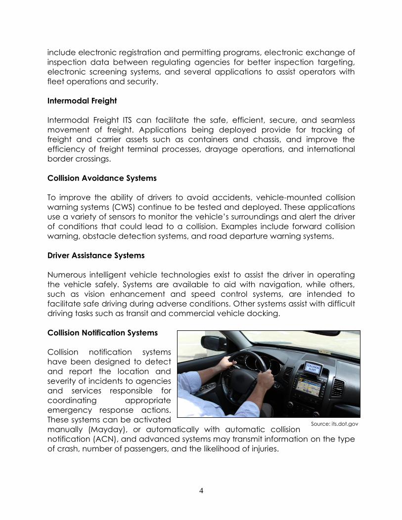
Collision Notification Systems
Collision notification systems
have been designed to detect
and report the location and
severity of incidents to agencies
and services responsible for
coordinating appropriate
emergency response actions.
These systems can be activated
manually (Mayday), or automatically with automatic collision
notification (ACN), and advanced systems may transmit information on the type
of crash, number of passengers, and the likelihood of injuries.
Source: its.dot.gov
5
Advancements in Technology
Technology is rapidly altering how transportation officials and transit service
providers improve operation efficiency and safety in real-time. New and
innovative technologies are integrated into both personal vehicles and devices,
improving the overall traveler experience. Some of the new technologies are
listed below:
Transit ITS
Computer Aided Dispatch
Computer Aided Dispatch (CAD) systems are a way in which dispatch
can communicate efficiently, in real time, with their entire fleet. “It allows
dispatchers to quickly look up driver schedules, send text messages to
drivers, and track the roadworthy status of every vehicle”
(trapezegroup.com).
Automatic Vehicle Location
The Automatic Vehicle Location (AVL) systems enable transit agencies to
easily monitor and collect data on their fleet’s location and performance.
This data is translated into real-time bus arrival information for passengers,
and an improved perception of transit reliability. The system is practical,
time-saving, and increases schedule adherence. If the system was linked
to other systems, potential uses may include tracking where traffic delays
are occurring on highways since multiple transit vehicles are using the
network.
Automatic Passenger Counter
The Automatic Passenger Counter (APC) technology supplies precise
ridership data directly from the vehicle to the dispatch center’s database.
APCs use wireless, infrared sensor technology to collect the necessary
counts, reducing time and money spent. This is an important tool from a
planning standpoint because population distribution can be revealed
through the ridership data collected.
Highway ITS
Dynamic Message Signs
Dynamic Message Signs (DMS) allow ITS operators to share information
collected from associated freeway management technologies. DMS
6
helps alert travelers of traffic congestion, accidents, travel time,
construction, speed limits, and much more.
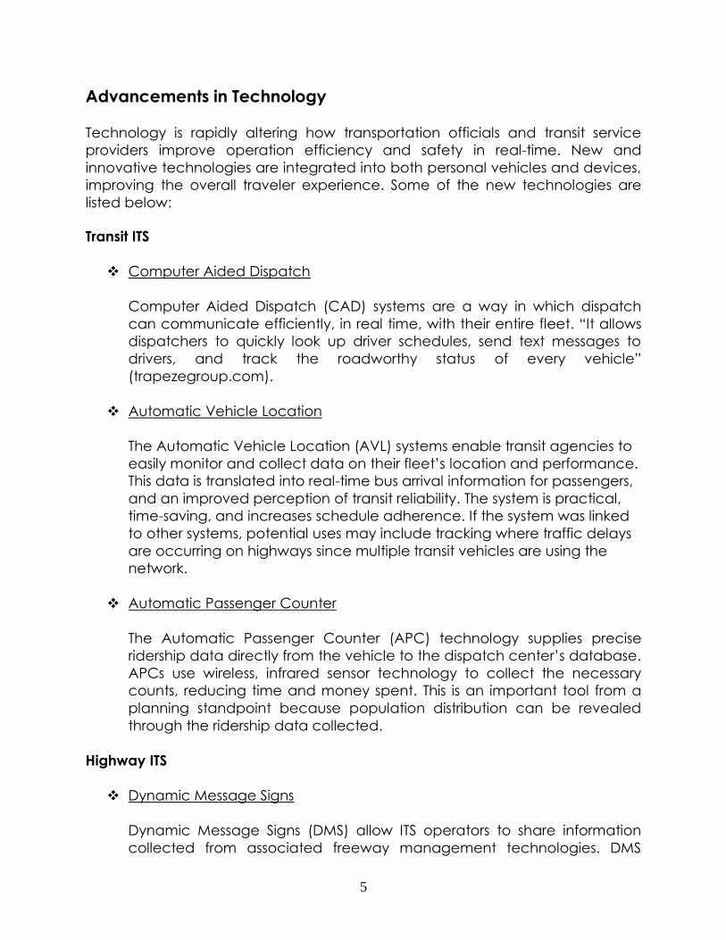
Adaptive Signal Control Technologies
The Adaptive Signal Control Technologies (ASCT) accommodates current
traffic patterns to promote smooth flow and ease traffic congestion. Other
benefits include reduction in fuel consumption and travel time reliability.
The Genesee County Road Commission (GCRC) has installed the InSync
Adaptive Traffic Signal Control System into 7 intersections along Holly
Road in Genesee County. As seen below, this system detects and collects
vehicle data by processing video images and automatically optimizing
the changing of traffic signals to instantly adapt to real time traffic
demand.
Public Information
In the past decade there has been a significant increase in public access
to ITS. Drivers have access to current conditions (weather, road,
emergency) through the use of innovative wireless applications. Traveler
information programs may use in-vehicle devices to display traveler
information or a variety of roadside technologies, such as dynamic
message signs and highway advisory radio.
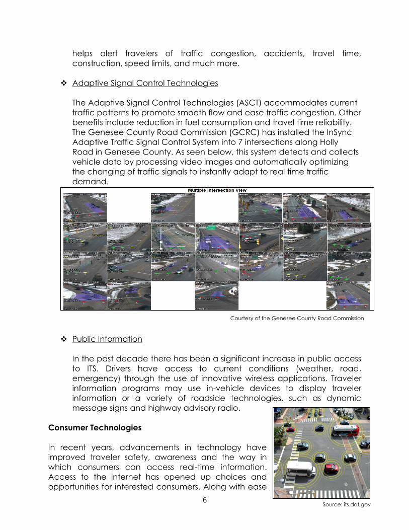
Consumer Technologies
In recent years, advancements in technology have
improved traveler safety, awareness and the way in
which consumers can access real-time information.
Access to the internet has opened up choices and
opportunities for interested consumers. Along with ease
Courtesy of the Genesee County Road Commission
Source: its.dot.gov
7
of access, many ITS technologies can be purchased and used by consumers
without control by governmental agencies. More common technology seen on
the roads today include vehicles with safety-related ITS components. A
reduction in vehicle accidents can be accounted for by such technologies as
vehicle-to-vehicle communication. The Intelligent Transportation Systems Joint
Program Office states that “vehicle-to-vehicle (V2V) communication exchanges
anonymous, vehicle-based data regarding position, speed, and location to
sense threats and hazard”. Overall, this technology will change the way
individuals receive and use real-time information.
Intelligent Transportation System Plans
There are currently two ITS plans that serve Genesee County: The Michigan
Department of Transportation (MDOT) Bay Region ITS Plan and the Flint Mass
Transportation Authority (MTA) ITS Implementation Plan.
MDOT Bay Region ITS Architecture and Deployment Plan
The Bay Regional ITS Architecture and Deployment plan provides a guide for
development in the Michigan Department of Transportation (MDOT) Bay Region
and ensures compatibility of the regional system. The Bay Region includes
Tuscola, Sanilac, Saginaw, Midland, Lapeer, Isabella, Huron, Gratiot, Gladwin,
Genesee, Clare, Bay and Arenac Counties. The regional focus of this plan
allows it to improve traffic operations through the region as a whole rather than
focusing on details in each county. The MDOT Regional Plan is the overarching
document for ITS Architecture in any given region. Project conformance to the
regional ITS architecture is a requirement for any agency in the region to be
eligible for federal funding of an ITS project.
Genesee County Metropolitan Planning Commission (GCMPC) staff was
involved in the previous development of the Bay Region ITS plan to ensure
regionally significant projects in Genesee County were included in the plan and
that the regional system would be compatible with the plans in Genesee
County. Most recently, MDOT has begun an administrative update to the Bay
Regional Architecture and Deployment Plan and has asked for GCMPC staff to
participate and contribute where possible. The updated version is expected to
be complete in the fall of 2014.
Flint Mass Transportation Authority ITS Implementation
The Flint Mass Transportation Authority (MTA) has worked diligently to identify
and adopt appropriate Intelligent Transportation System solutions to improve the
effectiveness and efficiency of transit service in and around Genesee County.
The 2005 Intelligent Transportation System Architecture and Deployment Plan is a
8
major initiative by the MTA to plan short and long-term approaches to deploying
Intelligent Transportation Systems technologies.
In recent years, MTA has made significant progress with the installation of transit
management techniques including computer aided dispatch (CAD) equipment
and automatic vehicle location (AVL) components. Additionally, all MTA
vehicles both paratransit and fixed route are equipped with Mobile Data
Terminals (MDTs). Currently paratransit vehicles are using this technology, while
fixed route setup and testing will occur through 2014. The MTA’s wireless internet,
phone, and radio systems operate on 3 frequencies (450, 800, & 900 MHz)
provided by their communications tower. This utility serves point-to-point contact
connections to all service centers owned by MTA in Genesee County. The MTA’s
most recent ITS projects also utilize the tower’s services and other local
municipalities and agencies have the option to improve ITS communications by
leasing space on the tower.
At the end of 2013, an Enterprise Asset Management (EAM) system was
introduced and will soon be fully integrated for the purchasing and finance
departments. EAM software allows agencies to service their fleet by
electronically keeping track of parts, services, and labor to have a more
efficient and effective maintenance department. In fiscal year 2014, both an
Interactive Voice Response (IVR) system and a Network Video Recording (NVR)
system will be installed on transit vehicles. These ITS upgrades will help improve
overall data collection, transit scheduling, and passenger security. In the
summer of 2014, the MTA will begin a technology assessment plan to determine
the future course of MTA technology based on current need and future
demand in service.
9
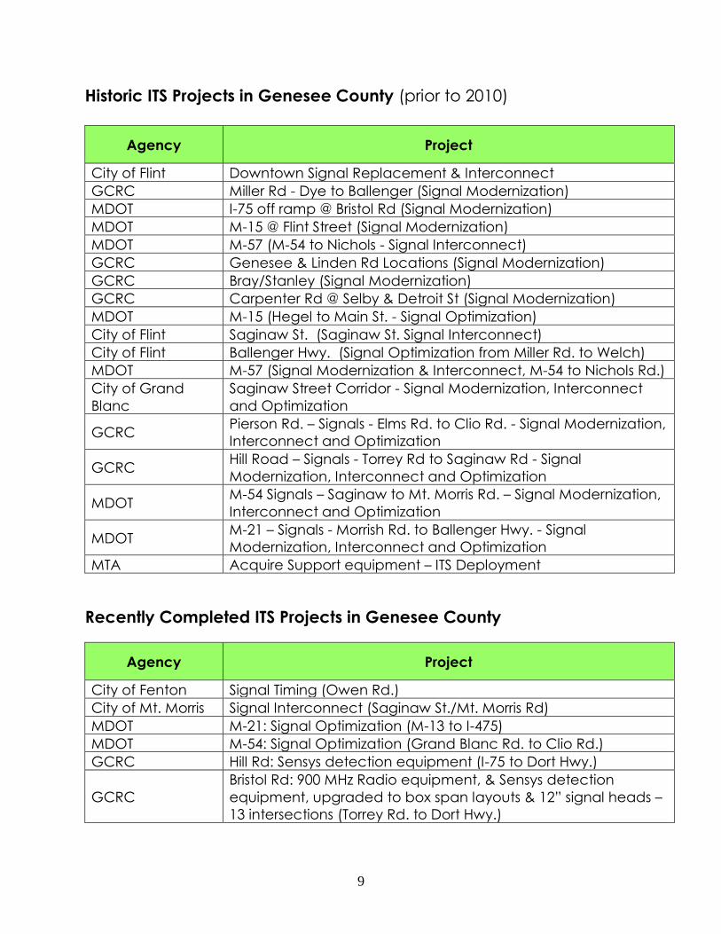
Historic ITS Projects in Genesee County (prior to 2010)
Agency Project
City of Flint Downtown Signal Replacement & Interconnect
GCRC Miller Rd - Dye to Ballenger (Signal Modernization)
MDOT I-75 off ramp @ Bristol Rd (Signal Modernization)
MDOT M-15 @ Flint Street (Signal Modernization)
MDOT M-57 (M-54 to Nichols - Signal Interconnect)
GCRC Genesee & Linden Rd Locations (Signal Modernization)
GCRC Bray/Stanley (Signal Modernization)
GCRC Carpenter Rd @ Selby & Detroit St (Signal Modernization)
MDOT M-15 (Hegel to Main St. - Signal Optimization)
City of Flint Saginaw St. (Saginaw St. Signal Interconnect)
City of Flint Ballenger Hwy. (Signal Optimization from Miller Rd. to Welch)
MDOT M-57 (Signal Modernization & Interconnect, M-54 to Nichols Rd.)
City of Grand
Blanc
Saginaw Street Corridor - Signal Modernization, Interconnect
and Optimization
GCRC Pierson Rd. – Signals - Elms Rd. to Clio Rd. - Signal Modernization,
Interconnect and Optimization
GCRC Hill Road – Signals - Torrey Rd to Saginaw Rd - Signal
Modernization, Interconnect and Optimization
MDOT M-54 Signals – Saginaw to Mt. Morris Rd. – Signal Modernization,
Interconnect and Optimization
MDOT M-21 – Signals - Morrish Rd. to Ballenger Hwy. - Signal
Modernization, Interconnect and Optimization
MTA Acquire Support equipment – ITS Deployment
Recently Completed ITS Projects in Genesee County
Agency Project
City of Fenton Signal Timing (Owen Rd.)
City of Mt. Morris Signal Interconnect (Saginaw St./Mt. Morris Rd)
MDOT M-21: Signal Optimization (M-13 to I-475)
MDOT M-54: Signal Optimization (Grand Blanc Rd. to Clio Rd.)
GCRC Hill Rd: Sensys detection equipment (I-75 to Dort Hwy.)
GCRC
Bristol Rd: 900 MHz Radio equipment, & Sensys detection
equipment, upgraded to box span layouts & 12” signal heads –
13 intersections (Torrey Rd. to Dort Hwy.)
10
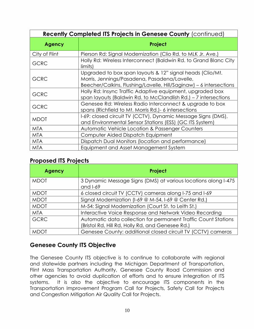
Recently Completed ITS Projects in Genesee County (continued)
Agency Project
City of Flint Pierson Rd: Signal Modernization (Clio Rd. to MLK Jr. Ave.)
GCRC Holly Rd: Wireless Interconnect (Baldwin Rd. to Grand Blanc City
limits)
GCRC
Upgraded to box span layouts & 12” signal heads (Clio/Mt.
Morris, Jennings/Pasadena, Pasadena/Lavelle,
Beecher/Calkins, Flushing/Lavelle, Hill/Saginaw) – 6 intersections
GCRC Holly Rd: Insync Traffic Adaptive equipment, upgraded box
span layouts (Baldwin Rd. to McClandlish Rd.) – 7 intersections
GCRC Genesee Rd: Wireless Radio Interconnect & upgrade to box
spans (Richfield to Mt. Morris Rd.)- 6 intersections
MDOT I-69: closed circuit TV (CCTV), Dynamic Message Signs (DMS),
and Environmental Sensor Stations (ESS) (GC ITS System)
MTA Automatic Vehicle Location & Passenger Counters
MTA Computer Aided Dispatch Equipment
MTA Dispatch Dual Monitors (location and performance)
MTA Equipment and Asset Management System
Proposed ITS Projects
Agency Project
MDOT 3 Dynamic Message Signs (DMS) at various locations along I-475
and I-69
MDOT 6 closed circuit TV (CCTV) cameras along I-75 and I-69
MDOT Signal Modernization (I-69 @ M-54, I-69 @ Center Rd.)
MDOT M-54: Signal Modernization (Court St. to Leith St.)
MTA Interactive Voice Response and Network Video Recording
GCRC Automatic data collection for permanent Traffic Count Stations
(Bristol Rd, Hill Rd, Holly Rd, and Genesee Rd.)
MDOT Genesee County: additional closed circuit TV (CCTV) cameras
Genesee County ITS Objective
The Genesee County ITS objective is to continue to collaborate with regional
and statewide partners including the Michigan Department of Transportation,
Flint Mass Transportation Authority, Genesee County Road Commission and
other agencies to avoid duplication of efforts and to ensure integration of ITS
systems. It is also the objective to encourage ITS components in the
Transportation Improvement Program Call for Projects, Safety Call for Projects
and Congestion Mitigation Air Quality Call for Projects.

11
Moving Ahead for Progress in the 21st Century Act (MAP-21)
ITS architectures satisfy the conformity requirements first established in the
Transportation Equity Act for the 21st Century (TEA-21) highway bill and
continued in the Moving Ahead for Progress in the 21st Century Act (MAP-21) bill
passed in 2012.
Next Steps
As the integration of intelligent transportation systems increase in transportation
infrastructure and vehicles, the Genesee County Metropolitan Planning
Commission (GCMPC) staff will continue to be directly involved with any
updates to ITS Architecture plans that serve Genesee County. This will ensure
goals, objectives, and projects of the County stay current and consistent within
the entire Bay Region.