intermunicipal planning for oatka creek watersheds summit... · intermunicipal planning for the...
TRANSCRIPT
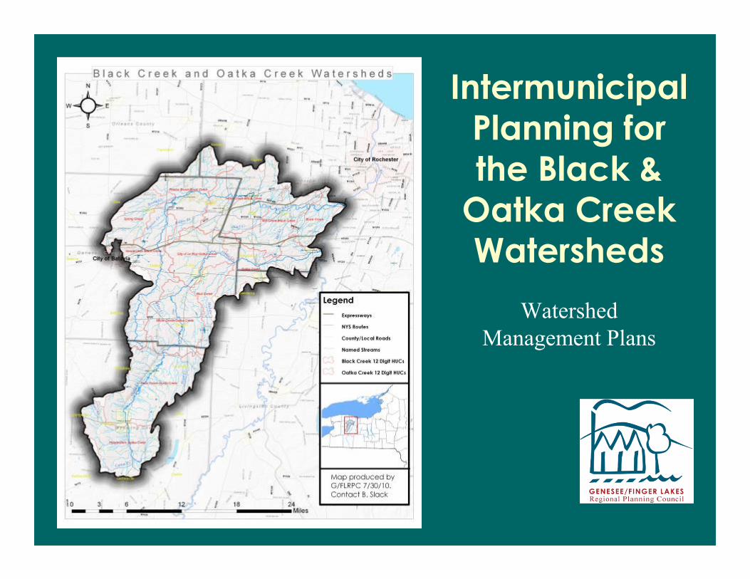
Intermunicipal
Planning for
the Black &
Oatka Creek Watersheds
Watershed
Management Plans

A brief word from our sponsors…
“This project is being developed for the New
York State Department of State Division of
Coastal Resources with funds provided under
Title 11 of the Environmental Protection Act
Local Waterfront Revitalization Program.”

A brief word from our sponsors…
Town of Wheatland, NY – EPF Project Sponsor

Drawing from a Broad Coalition
http://www.blackcreekwatershed.org/
Soil and Water
Conservation Districts
in Five Counties
31 Municipalities
Various other federal, state and local
agencies…
LOCAL CITIZENS &
STAKEHOLDERS
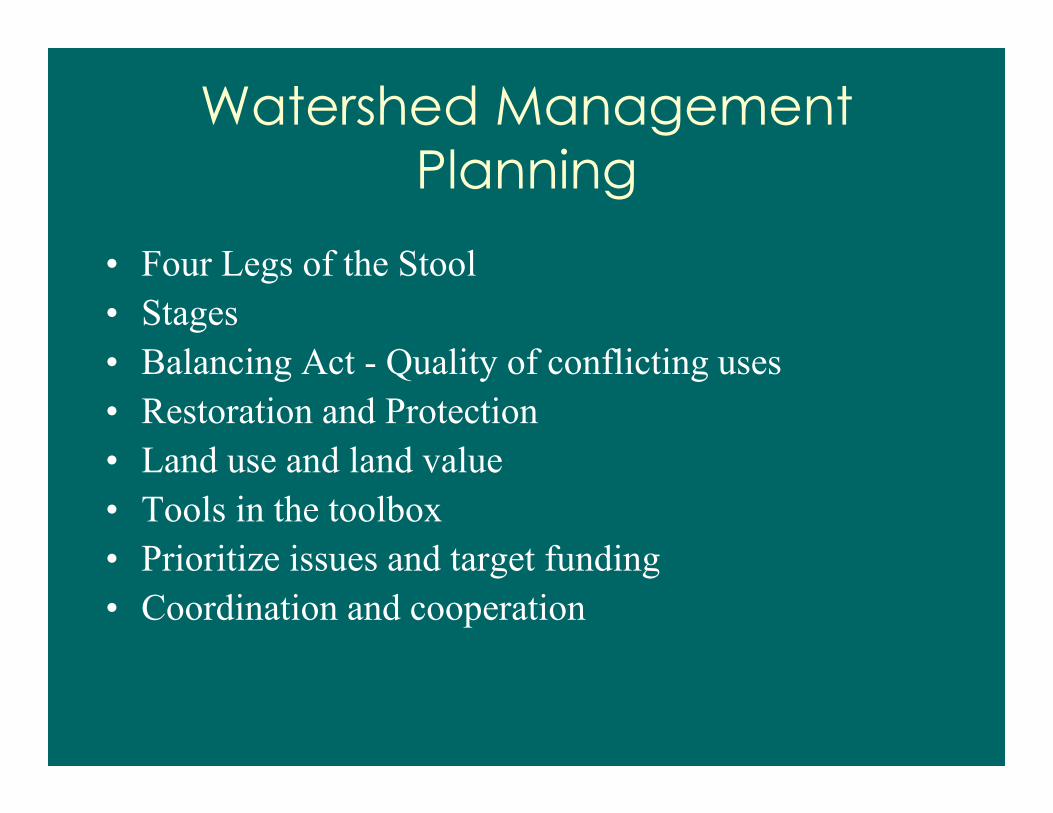
Watershed Management
Planning
• Four Legs of the Stool
• Stages
• Balancing Act - Quality of conflicting uses
• Restoration and Protection
• Land use and land value
• Tools in the toolbox
• Prioritize issues and target funding
• Coordination and cooperation

Four Legs of the Stool
• Oversight and
Involvement
• Education and Outreach
• Public Participation
• Fact Finding

Stages
• Existing State
• Desired State
• Strategies and Actions
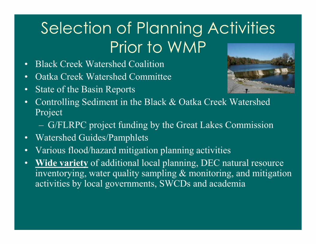
Selection of Planning Activities
Prior to WMP• Black Creek Watershed Coalition
• Oatka Creek Watershed Committee
• State of the Basin Reports
• Controlling Sediment in the Black & Oatka Creek Watershed Project
– G/FLRPC project funding by the Great Lakes Commission
• Watershed Guides/Pamphlets
• Various flood/hazard mitigation planning activities
• Wide variety of additional local planning, DEC natural resource inventorying, water quality sampling & monitoring, and mitigation activities by local governments, SWCDs and academia

Watershed Management PlanComponents
• Major components:
• Project Advisory Committees
• Characterization
• Sub-watershed Evaluation
• Regulatory/Programmatic Evaluation
• Watershed Recommendations and
Implementation Schedule


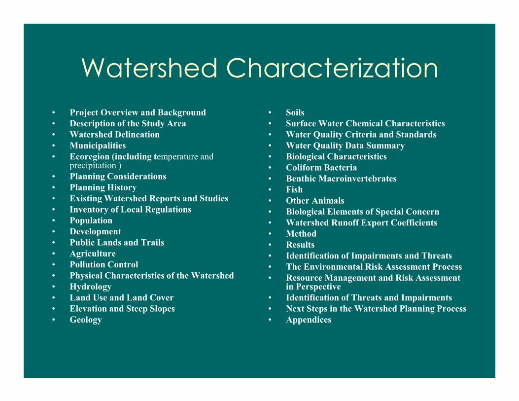
Watershed Characterization
• Project Overview and Background
• Description of the Study Area
• Watershed Delineation
• Municipalities
• Ecoregion (including temperature and precipitation )
• Planning Considerations
• Planning History
• Existing Watershed Reports and Studies
• Inventory of Local Regulations
• Population
• Development
• Public Lands and Trails
• Agriculture
• Pollution Control
• Physical Characteristics of the Watershed
• Hydrology
• Land Use and Land Cover
• Elevation and Steep Slopes
• Geology
• Soils
• Surface Water Chemical Characteristics
• Water Quality Criteria and Standards
• Water Quality Data Summary
• Biological Characteristics
• Coliform Bacteria
• Benthic Macroinvertebrates
• Fish
• Other Animals
• Biological Elements of Special Concern
• Watershed Runoff Export Coefficients
• Method
• Results
• Identification of Impairments and Threats
• The Environmental Risk Assessment Process
• Resource Management and Risk Assessment in Perspective
• Identification of Threats and Impairments
• Next Steps in the Watershed Planning Process
• Appendices
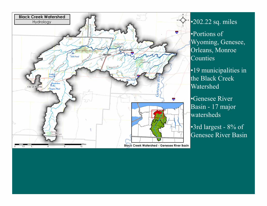
•202.22 sq. miles
•Portions of
Wyoming, Genesee,
Orleans, Monroe
Counties
•19 municipalities in
the Black Creek
Watershed
•Genesee River
Basin - 17 major
watersheds
•3rd largest - 8% of
Genesee River Basin

•216.8 sq. miles
•Portions of Wyoming, Genesee,
Livingston and Monroe Counties
•25 municipalities in the Oatka
Creek Watershed
•Genesee River Basin - 17
watersheds
•2nd largest - 9% of the Genesee
River Basin.

Land Use
within the
Black
Creek
Watershed
Property Classification Category Acres% of Black Creek Watershed
Area
(1) Agricultural
Property used for the production of crops or
livestock60,302.89 48.5%
(2) Residential
Property used for human habitation 33,566.89 27.0%
(3) Vacant Land
Property that is not in use, is in temporary use, or lacks
permanent improvement14,393.92 11.6%
(4) Commercial
Property used for the sale of goods and/or services 1,832.23 1.5%
(5) Recreation and Entertainment
Property used by groups for recreation, amusement, or
entertainment1,650.59 1.3%
(6) Community Services
Property used for the well being of the community 1,961.95 1.6%
(7) Industrial
Property used for the production and fabrication of
durable and nondurable man-made goods833.56 0.7%
(8) Public Services
Property used to provide services to the general public 1,125.89 0.9%
(9) Wild, Forested, Conservation Lands & Public
Parks
Reforested lands, preserves, and private hunting and
fishing clubs
5,241.46 4.2%
Unclassified
Property or land that has not been or is unable to be
classified3,486.92 2.8%
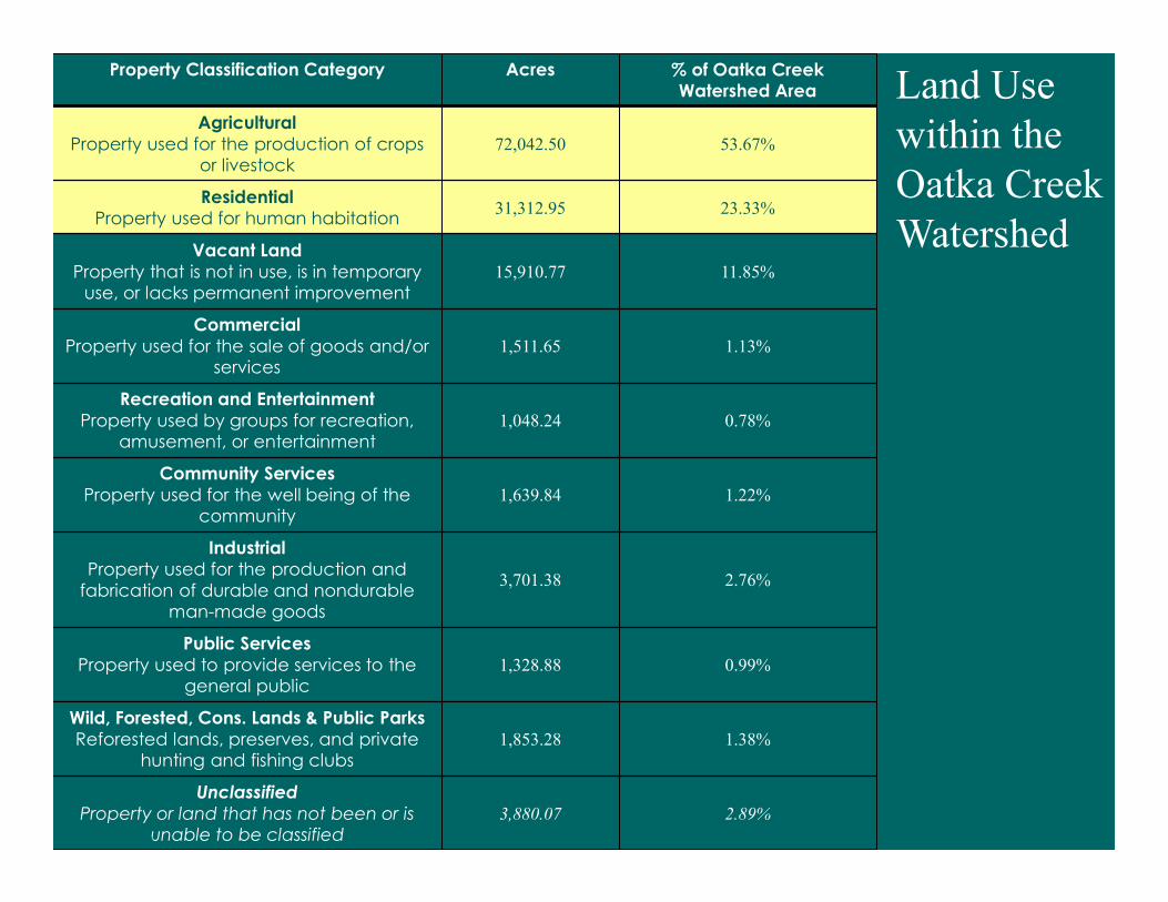
Property Classification Category Acres % of Oatka Creek Watershed Area
Agricultural
Property used for the production of crops or livestock
72,042.50 53.67%
Residential
Property used for human habitation31,312.95 23.33%
Vacant Land
Property that is not in use, is in temporary use, or lacks permanent improvement
15,910.77 11.85%
Commercial
Property used for the sale of goods and/or services
1,511.65 1.13%
Recreation and Entertainment
Property used by groups for recreation, amusement, or entertainment
1,048.24 0.78%
Community Services
Property used for the well being of the community
1,639.84 1.22%
Industrial
Property used for the production and
fabrication of durable and nondurable man-made goods
3,701.38 2.76%
Public Services
Property used to provide services to the general public
1,328.88 0.99%
Wild, Forested, Cons. Lands & Public Parks
Reforested lands, preserves, and private hunting and fishing clubs
1,853.28 1.38%
Unclassified
Property or land that has not been or is
unable to be classified
3,880.07 2.89%
Land Use
within the
Oatka Creek
Watershed
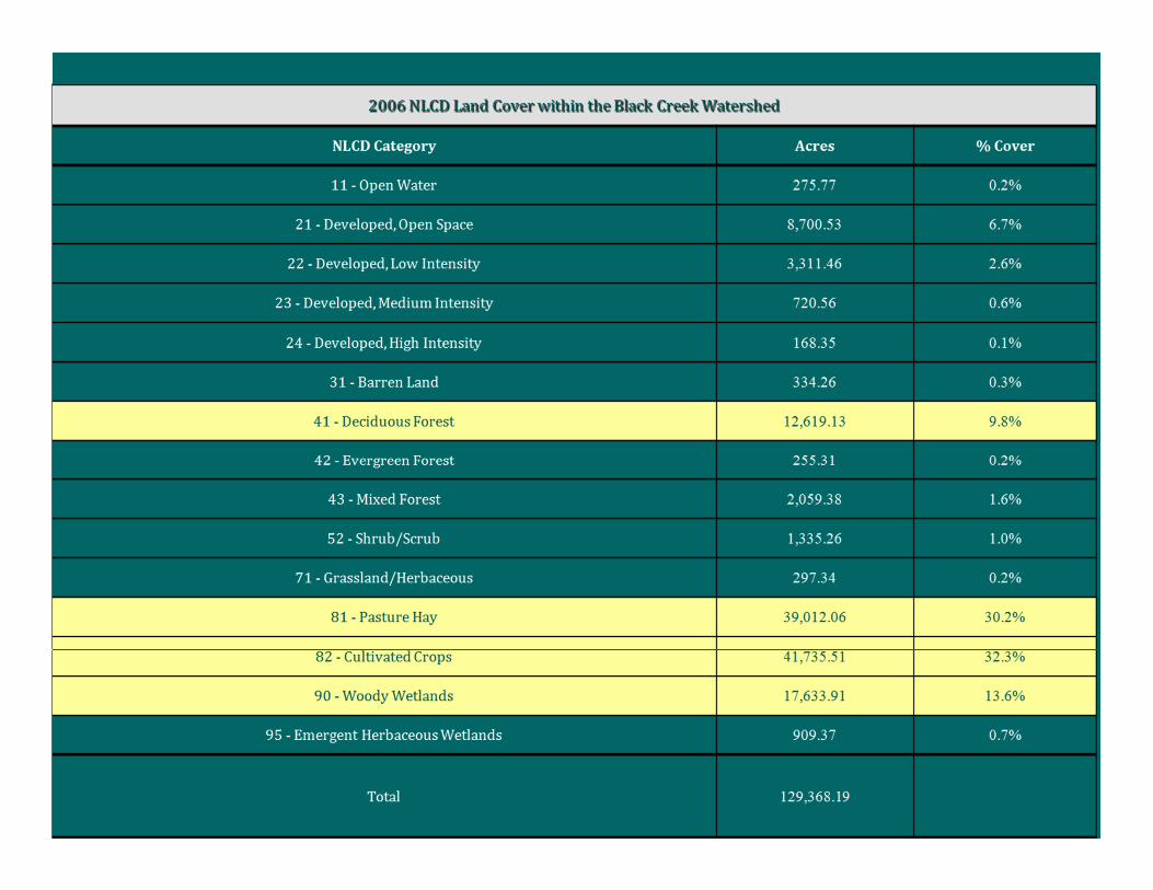
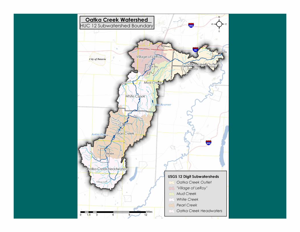
2006 NLCD Land Cover within the Oatka Creek Watershed
NLCD Category Acres % Cover
11 - Open Water 263.54 0.2%
21 - Developed, Open Space 6,233.06 4.5%
22 - Developed, Low Intensity 2,194.81 1.6%
23 - Developed, Medium Intensity 553.99 0.4%
24 - Developed, High Intensity 130.77 0.1%
31 - Barren Land 521.52 0.4%
41 - Deciduous Forest 23,331.22 16.9%
42 - Evergreen Forest 819.75 0.6%
43 - Mixed Forest 4,733.67 3.4%
52 - Shrub/Scrub 5,663.28 4.1%
71 - Grassland/Herbaceous 479.71 0.3%
81 - Pasture Hay 43,436.60 31.5%
82 - Cultivated Crops 43,042.30 31.2%
90 - Woody Wetlands 6,221.27 4.5%
95 - Emergent Herbaceous Wetlands 407.65 0.3%
Total 138,033.14
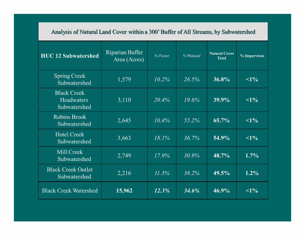

Analysis of Natural Land Cover within a 300’ Buffer of All Streams, by Subwatershed
HUC 12
Subwatershed
Riparian Buffer
Area (Acres)% Forest %Wetland
Natural
Cover
Total
%
Imper
vious
Oatka Creek
Headwaters 4,034.2 42.4% 7.5% 50% <1%
Pearl Creek 6,345.1 32.4% 5.3% 37.7% <1%
White Creek 3,198.9 26.4% 18.8% 45.2% <1%
Mud Creek 1,368.8 19.2% 21.0% 40.2% <1%
Village of LeRoy 1,511.2 18.5% 26.2% 44.7% 2.3%
Oatka Creek Outlet 1,960.2 27.5% 27.4% 54.9% <1%
Oatka Creek Watershed 18,389.61 30.9% 13.4% 44.3% <1%

Black Creek WatershedSurface Water Chemical Characteristics
• USGS 04231000 Black Creek @ Churchville,
NY (2005-2009)
• NY-DEC RIBS1 Black Creek in Byron @
State Route 237 (2002)
• SUNY Brockport2 “Lower Black Creek”
(2010)1. Rotating Intensive Basin Study
2. Dr. Joseph C. Makarewicz, SUNY Brockport

Black Creek WatershedSurface Water Chemical Characteristics
Oatka Creek WatershedSurface Water Chemical Characteristics
NY-DEC Ambient Water Quality Standards
• Waterbody Classification: A-D based on
designated “best use”
Oatka Creek WatershedBiological Characteristics
Benthic Macroinvertebrates
• RIBS 1990s: “slightly impacted”
• RIBS 2005: “slightly impacted”


Black Creek Headwaters &
Spring Creek Subwatersheds• The Black Creek Headwaters is the largest or
second largest subwatershed in most categories,
followed in large part by the other upper
subwatershed, Spring Creek.
• Largely agricultural with steep slopes with a
significant number of Section 303(d)
Impaired/TMDL Waters.
Robins Brook and Hotel Creek
Subwatersheds• Fairly high wetland concentration
• Floodplains
• Fairly low slope
• Largely agricultural and forested lands outside
of the Village of Churchville and Bergen.

Black Creek Outlet and Mill
Creek Subwatersheds • Low relief
• Large floodplains
• More developed land cover
• Outside of the City of Batavia, the highest population
density as well as a high percentage of the 303d
Impaired/TMDL Waters
Oatka Creek Headwaters &
Pearl Creek Subwatersheds• Pearl Creek is the largest subwatershed.
• In general these two subwatersheds are
relatively undeveloped with a low percent of
impervious cover, high percent of forest cover,
riparian cover and agricultural uses, and fairly
low population density.
• TSS, sediment, streambank erosion,
nutrients, bacteria
• CAFOs, on-site waste water, 2 WWTP
(Warsaw and Pavilion)
• Streambank remediation
White Creek and Mud Creek
subwatersheds• Characterized by relatively low impervious
cover and forest cover, a high percentage of
wetlands in the case of the White Creek
subwatershed, agricultural uses, and fairly low
population density.
• White Creek
• nutrients, sediment, and coliform bacteria
management practices

Village of LeRoy and Oatka
Outlet subwatersheds • Relatively high population density and agricultural
uses, relatively low forest and riparian cover, and in the
case of the Oatka Creek Outlet subwatershed, very high
impervious cover.
• Village of LeRoy Subwatershed - Village of LeRoy
WWTP , elevated nutrients and coliform abundances
observed
• Oatka Creek Outlet Subwatershed – trout fishery


Summary of Local
Land Use
Regulations Among
Primary
Municipalities in
the Black Creek
Watershed

Summary of
Local Land
Use
Regulations
Among
Primary
Municipalities
in the Oatka
Creek
Watershed
Comprehensive Plan Zoning Site Plan
Review
Subdivision
Law
Provisions for
Planned Unit or
Cluster Dev’t
Erosion/
Sediment Control
Law
Flood Damage
Prevention
Town of Bergen* 19961983
(e-code)Yes Yes Yes Yes Yes
Town of Bethany* 2008 2008 Yes Yes Yes Yes Yes
Town of Byron*1993
(under revision)2013 Yes Yes Yes
Yes
(see General
Provisions)
Yes
Town of Caledonia 19641994
(ecode)Yes Yes Yes No Yes
Village of
Caledonia2003 1999 Yes Yes Yes unk unk
Town of Castile 1967 1996 Yes
No
(section
reserved)
YesNo
(section reserved)unk
Town of Covington 2006 2007 Yes Yes Yes
No
(plat review by
SWCD)
Yes
Town of
Gainesville
1995
(within zoning)2004 No No No No Yes
Town of LeRoy 2002 1999 Yes Yes Yes No Yes
Village of LeRoy 2001 1990 Yes Yes Yes No Yes
Town of
Middlebury*
2009
(within zoning)2009 Yes No Yes No Yes
Town of
Orangeville2009
2009
(online)Yes No Yes Yes Yes
Town of Pavilion 2003 2006 Yes Yes Yes No Yes
Town of Perry 1969 2000 Yes Yes Yes No Yes
Town of Riga 20082008
(ecode)Yes Yes Yes Yes Yes
Village of
Scottsville2004 2008 Yes Yes No No Yes
Town of Stafford* 20092009
(e-code)Yes Yes Yes No Yes
Town of Warsaw2004
(within zoning)2004 Yes Yes Yes No Yes
Village of Warsaw 1994 1995 Yes Yes Yes No Yes
Town of
Wheatland*2004
2008
(e-code)Yes Yes Yes Yes Yes
Village of
WyomingNone 1994 Yes No Yes No Yes


Recommendation Categories• Coordination, Collaboration & Partnership
• Agriculture
• Stormwater Management & Erosion Control
• Forestry & Silviculture Management
• On-Site Wastewater Management Systems (OWTS)
• Waste Water Treatment Plant Systems (WWTPS)
• Hazardous Waste Management
• Roads and Highways
• Wetlands, Riparian Zones, and Floodplains
• Regulatory Management
• Reduce nutrient and contaminant inputs to surface waters
• Natural Resource and Habitat Protection

Highest Ranked
Recommendations
Black Creek Watershed• Agriculture
• Expand agricultural and soil health initiatives that provide technical
assistance and incentives to implement practices such as cover
cropping, nutrient management, conservation tillage, conservation
cropping systems
• Stormwater Management & Erosion Control
• Create green infrastructure standards
• Restore very severe streambank segments using ecologically-based
stream restoration
• Waste Water Treatment Plant Systems (WWTPS)
• Complete a characterization of WWTP effluent to assess levels of
contaminants that are discharged
• Reduce nutrient inputs and contaminants to surface waters
• Develop nutrient and sediment reduction strategies for sub-watersheds
and continue working with NYSDEC and TMDL project

Highest Ranked
Recommendations
Oatka Watershed• Agriculture
• Create and maintain riparian buffer zones for streams adjacent to
agricultural land starting with the critical areas
• Stormwater Management & Erosion Control
• Restore very severe streambank segments using ecologically-based
stream restoration
• Forestry & Silviculture Management
• Encourage private landowners to apply sound forest management
practices to woodlands: NYS Forestry Best Management Practices for
Water Quality
• Waste Water Treatment Plant Systems (WWTPS)
• Upgrade WWTP to tertiary treatment or consider closing and
transferring sanitary flows
• Regulatory Management
• Enforce floodplain development regulations

Public Meetings
• Oatka Creek Watershed
– February 9, 2012, 6:30-8:00 pm
– August 28, 2014, 6:30-8:00 pm
– Pavilion Fire Department Recreation Hall located at 11302 Lake Road, Pavilion, New York
• Black Creek Watershed
– February 7, 2012, 6:30-8:00 pm
– September 3, 2014, 6:30-8:00 pm
– Byron Fire Department Recreation Hall located at 6357 East Main Street, Byron, New York
