international boundary and water commission … · about the international boundary and water...
TRANSCRIPT
INTERNATIONAL BOUNDARY AND WATER COMMISSION UNITED STATES AND MEXICO
UNITED STATES SECTION
Management Discussion & Analysis Fiscal Year 2009
Prepared: Dec. 2009 Revised: Mar. 2010
TABLE OF CONTENTS
HEADING PAGE
MISSION, VISION AND PHILOSOPHY........................................................................................1
ABOUT THE INTERNATIONAL BOUNDARY AND WATER COMMISSION ...............................2 History ...............................................................................................................................2 The United States – Mexico Boundary............................................................................11
ORGANIZATION.........................................................................................................................12 Organizational Structure .................................................................................................12 Overview of Organizational Structure .............................................................................13 Employee Distribution .....................................................................................................15
OFFICE LOCATIONS AND GENERAL RESPONSIBILITES .....................................................16 U.S. Section Field Offices ...............................................................................................16
STRATEGIC GOALS AND ACCOMPLISHMENTS ....................................................................19 Strategic Goal 1 – Boundary Preservation......................................................................19 Strategic Goal 2 – Water Quantity Operations................................................................20 Strategic Goal 3 – Water Quality Management...............................................................22 Strategic Goal 4 – Resource and Asset Management ....................................................25
FINANCE ....................................................................................................................................28 Financial Highlights .........................................................................................................28 Overview of Financial Position ........................................................................................29 Principal Financial Statements........................................................................................32 Internal Controls and Compliance with Laws and Regulations .......................................33
- i -
MISSION, VISION AND PHILOSOPHY
M I S S I O N
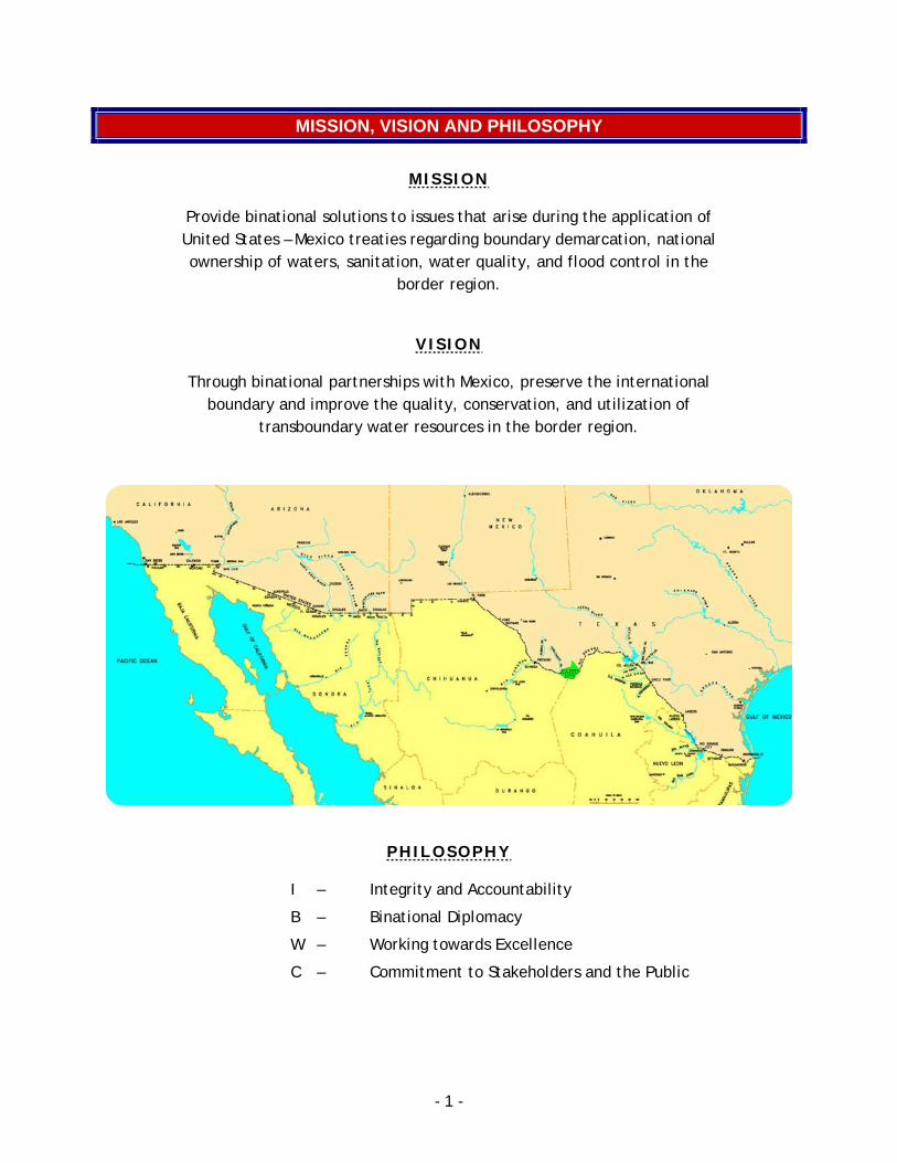
Provide binational solutions to issues that arise during the application of United States – Mexico treaties regarding boundary demarcation, national ownership of waters, sanitation, water quality, and flood control in the
border region.
V I S I O N
Through binational partnerships with Mexico, preserve the international boundary and improve the quality, conservation, and utilization of
transboundary water resources in the border region.
P H I L O S O P H Y
I – Integrity and Accountability
B – Binational Diplomacy
W – Working towards Excellence
C – Commitment to Stakeholders and the Public
- 1 -
ABOUT THE INTERNATIONAL BOUNDARY AND WATER COMMISSION
The International Boundary and Water Commission (IBWC) is a binational organization, established to apply boundary and water treaties and agreements between the United States (U.S.) and Mexico. The IBWC consists of a U.S. Section and a Mexican Section. Each Section is administered independently of the other, and is headed by an Engineer Commissioner, who is appointed by his respective President. The U.S. Section receives foreign policy guidance from the U.S. Department of State, while the Mexican Section is administratively linked to the Secretariat of Foreign Relations of Mexico.
The U.S. and Mexican Sections maintain their respective headquarters in the adjoining cities of El Paso, Texas and Ciudad Juárez, Chihuahua. Each Section is responsible for maintaining its own legal counsel, engineering staff, and administrative staff, and has field offices situated along the border to operate and maintain joint works. The Commissioner, two principal engineers, a legal adviser, and a secretary, designated by each Government as members of its Section, are entitled to the privileges and immunities appertaining to diplomatic officers. The Commission meets on a regular basis, alternating the place of meetings, and the staffs of the two Sections are in frequent contact. Pursuant to the 1944 Treaty, decisions of the IBWC are recorded in the form of Minutes that, following approval by the U.S. and Mexican governments, enter into force as binding international agreements of the U.S and Mexico.
HISTORY
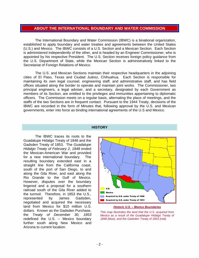
The IBWC traces its roots to the Guadalupe Hidalgo Treaty of 1848 and the Gadsden Treaty of 1853. The Guadalupe Hidalgo Treaty of February 2, 1848 ended the Mexican-American War and provided for a new international boundary. The resulting boundary extended east in a straight line from the California coast, south of the port of San Diego, to and along the Gila River, and east along the Rio Grande to the Gulf of Mexico. However, disputes over the boundary lingered and a proposal for a southern railroad south of the Gila River added to the turmoil. Therefore, in 1853 the U.S., represented by James Gadsden, negotiated and acquired the necessary land from Mexico for $10 million U.S. dollars. Known as the Gadsden Purchase, the Treaty of December 30, 1853 redefined the U.S. – Mexico boundary further south along New Mexico and Arizona to current location.
This map illustrates the land that the U.S. acquired from Mexico as a result of the Guadalupe Hidalgo Treaty of 1848 (blue), and the Gadsden Treaty of 1853 (red).
Historic U.S. – Mexico Boundaries
- 2 -
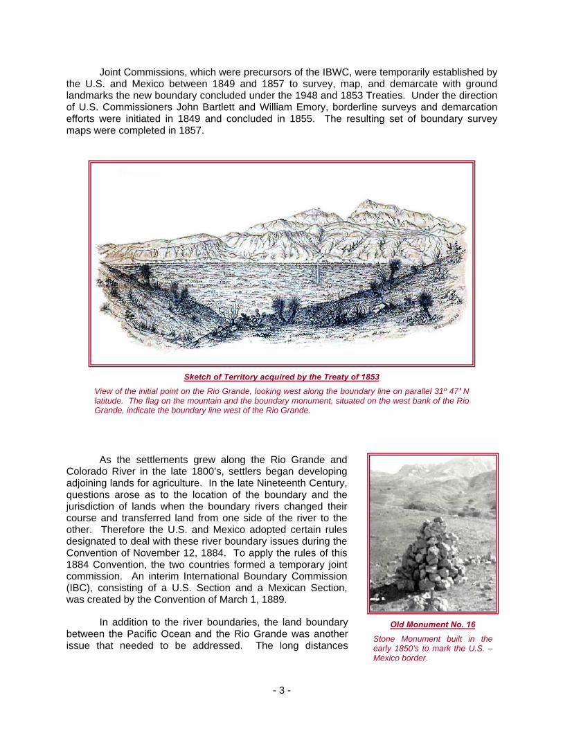
Sketch of Territory acquired by the Treaty of 1853
View of the initial point on the Rio Grande, looking west along the boundary line on parallel 31º 47′ N latitude. The flag on the mountain and the boundary monument, situated on the west bank of the Rio
hich were precursors of the IBWC, were temporarily established by the U.S. and Mexico between 1849 and 1857 to survey, map, and demarcate with ground landma
s the settlements grew along the Rio Grande and Colorado River in the late 1800’s, settlers began developing adjoinin
land boundary between the Pacific Ocean and the Rio Grande was another issue that needed to be addressed. The long distances
Grande, indicate the boundary line west of the Rio Grande.
Joint Commissions, w
rks the new boundary concluded under the 1948 and 1853 Treaties. Under the direction of U.S. Commissioners John Bartlett and William Emory, borderline surveys and demarcation efforts were initiated in 1849 and concluded in 1855. The resulting set of boundary survey maps were completed in 1857.
A
g lands for agriculture. In the late Nineteenth Century, questions arose as to the location of the boundary and the jurisdiction of lands when the boundary rivers changed their course and transferred land from one side of the river to the other. Therefore the U.S. and Mexico adopted certain rules designated to deal with these river boundary issues during the Convention of November 12, 1884. To apply the rules of this 1884 Convention, the two countries formed a temporary joint commission. An interim International Boundary Commission (IBC), consisting of a U.S. Section and a Mexican Section, was created by the Convention of March 1, 1889.
In addition to the river boundaries, the Old Monument No. 16
Stone Monument built in the early 1850’s to mark the U.S. – Mexico border.
- 3 -
betwee al dest ent atioCom
n vey started at 91 and concluded at the San
During this survey, IBC crews
s border populations increased between the years of 1906 and 1968, the Commission constructed 18 additional boundary monuments for a total of 276. The IBWC later erected 442 smaller concrete markers to enhance demarcation along the western boundary from 1976 to 1986.
It is this 1889 IBC that is considered to be the direct predecessor to the modern day IBWC. The International Boundary Commission was renamed to the International Boundary and Wa
rs between the U.S. and Mexico, Rio Grande flood control and channel stabilization, and border sanitation.
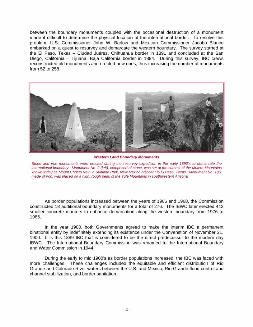
n the boundary monuments coupled with the occasionmade it difficult to determine the physical location of the internproblem, U.S. Commissioner John W. Barlow and Mexican embarked on a quest to resurvey and demarcate the western bouthe El Paso, Texas – Ciudad Juárez, Chihuahua border in 18Diego, California – Tijuana, Baja California border in 1894. reconstructed old monuments and erected new ones; thus increasing the number of monuments from 52 to 258.
ruction of a monumnal border. To resolve this
missioner Jacobo Blanco dary. The sur
Western Land Boundary Monuments
Stone and iron monuments were erected during the resurvey expedition in the early 1890’s to demarcate the international boundary. Monument No. 2 (left), composed of stone, was set at the summit of the Mulero Mountains known today as Mount Christo Rey, in Sunland Park, New Mexico adjacent to El Paso, Texas. Monument No. 185, made of iron, was placed on a high, ro western Arizona. ugh peak of the Tule Mountains in south
A
In the year 1900, both Governments agreed to make the interim IBC a permanent binational entity by indefinitely extending its existence under the Convenstion of November 21, 1900.
ter Commission in 1944
During the early to mid 1900's as border populations increased, the IBC was faced with more challenges. These challenges included the equitable and efficient distribution of Rio Grande and Colorado River wate
- 4 -
- 5 -
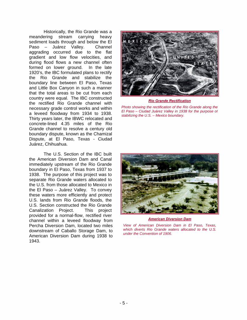
Historically, the Rio Grande was a meandering stream carrying heavy sediment loads through and below the El Paso – Juárez Valley. Channel aggrading occurred due to the flat gradient and low flow velocities, and during flood flows a new channel often formed on lower ground. In the late 1920’s, the IBC formulated plans to rectify the Rio Grande and stabilize the boundary line between El Paso, Texas and Little Box Canyon in such a manner that the total areas to be cut from each country were equal. The IBC constructed the rectified Rio Grande channel with necessary grade control works and within a leveed floodway from 1934 to 1938. Thirty years later, the IBWC relocated and concrete-lined 4.35 miles of the Rio Grande channel to resolve a century old boundary dispute, known as the Chamizal Dispute, at El Paso, Texas - Ciudad Juárez, Chihuahua.
The U.S. Section of the IBC built the American Diversion Dam and Canal immediately upstream of the Rio Grande boundary in El Paso, Texas from 1937 to 1938. The purpose of this project was to separate Rio Grande waters allocated to the U.S. from those allocated to Mexico in the El Paso – Juárez Valley. To convey these waters more efficiently and protect U.S. lands from Rio Grande floods, the U.S. Section constructed the Rio Grande Canalization Project. This project provided for a normal-flow, rectified river channel within a leveed floodway from Percha Diversion Dam, located two miles downstream of Caballo Storage Dam, to American Diversion Dam during 1938 to 1943.
Rio Grande Rectification
Photo showing the rectification of the Rio Grande along theEl Paso – Ciudad Juárez Valley in 1938 for the purpose of stabilizing the U.S. – Mexico boundary.
American Diversion Dam
View of American Diversion Dam in El Paso, Texas, which diverts Rio Grande waters allocated to the U.S. under the Convention of 1906.
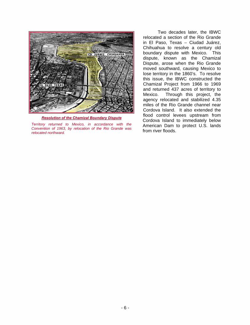
Two decades later, the IBWC relocated a section of the Rio Grande in El Paso, Texas – Ciudad Juárez, Chihuahua to resolve a century old boundary dispute with Mexico. This dispute, known as the Chamizal Dispute, arose when the Rio Grande moved southward, causing Mexico to lose territory in the 1860’s. To resolve this issue, the IBWC constructed the Chamizal Project from 1966 to 1969 and returned 437 acres of territory to Mexico. Through this project, the agency relocated and stabilized 4.35 mile hannel near
American Dam to protect U.S. lands from river floods.
s of the Rio Grande cCordova Island. It also extended the flood control levees upstream from Cordova Island to immediately below Resolution of the Chamizal Boundary Dispute
Territory returned to Mexico, in accordance wConvention of 1963, by relocation of the Rio Granrelocated northward.
ith the de was
- 6 -
- 7 -
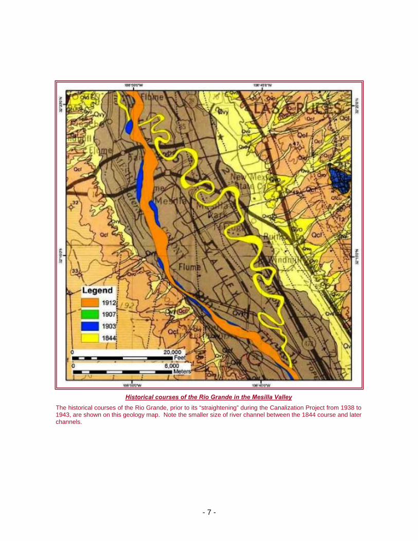
Historical courses of the Rio Grande in the Mesilla Valley
The historical courses of the Rio Grande, prior to its “straightening” during the Canalization Project from 1938 to 1943, are shown on this geology map. Note the smaller size of river channel between the 1844 course and laterchannels.

The U.S. and Mexican Governments directed the IBC in 1930 to address the flood control problems in the Lower Rio Grande Valley located in far south Texas. As a result, the IBC extended, raised, and straightened levees of the Rio Grande and its interior floodways in 1933. The IBWC later constructed Anzalduas Diversion Dam between 1956 and 1960 to allow for controlled diversion of floodwaters into the U.S. interior floodway. However, the 1958 flood demonstrated that certain improv ents to the system were needed, so the IBWC raised some levee reaches and extended the river levee eight miles upstream to Peñitas, Texas from 1958 to 1961. Unfortunately, Hurricane Beulah struck the region in 1967, devastating the Lower Rio Grande watershed with up to 35 inches of rain and causing major damage in both the U.S. and Mexico. The IBWC quickly responded by performing emergency repairs to the flood control system in 1968 and 1969. Soon thereafter in September 1970, the two Governments agreed to further increase the flood conveyance capacity of the system from 187,000 cfs to 250,000 cfs at the head of the valley. Beginning in 1970, the IBWC completed all the necessary flood control improvements by 1977; including levee raising, interior floodway modifications, and construction of Retamal Diversion Dam.
uring the 1940’s, the Commission conducted joint studies and investigations to determine the most feasible sites for the construction of major international reservoirs and hydroelectric power plants on the Rio Grande. Construction of international storage dams and power plants would provide flood control,rebconcluded that two such combinations on the Rio Grande would be feasible, the IBWC proceeded with the construction of the Falcon and Amistad International Storage Dams and Power Plants. The Falcon International Storage Dam and Power Plant was built in 1950 to 1954. Unlike Falcon, the Amistad project was constructed in two separate phases. The storage dam and reservoir was built in 1963 to 1969, and the U.S. and Mexican power plant facilities were constructed from 1980 and 1987.
emLower Rio Grande U.S. Main Floodway
Construction of the south levee along the Main Floodway in the Lower Rio Grande Valley of south Texas during 1934
D
Hurricane Beulah Flooding
Aerial photograph of a flooded community in Harlingen, Texas after Hurricane Beulah hit the Lower Rio Grande Valley in 1967. Note that only the rooftops were visible.
water conservation, creat nal, and electrical power benefits to
oth countries. Since the U.S. and Mexico io
- 8 -
- 9 -
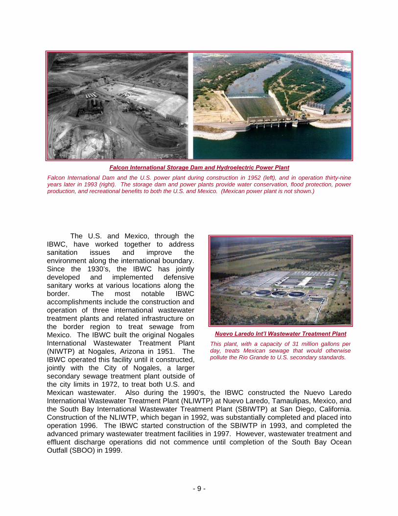
Falcon International Storage Dam and Hydroelectric Power Plant
construction in 1952 (left), and in operation thirty-nine ants
Falcon International Dam and the U.S. power plant duryears later in 1993 (right). The storage dam and power
ingpl
production, and recreational benefits to both the U.S. and
The U.S. and Mexico, through the IBWC, have worked together to address sanitation issues and improve the environment along the international boundary. Since the 1930’s, the IBWC has jointly developed and implemented defensive sanitary works at various locations along theborder. The most notable IBWC accomplishments include the construction and operation of three international wastewatertreatme
provide water conservation, flood protection, power Mexico. (Mexican power plant is not shown.)
0’s, the IBWC constructed the Nuevo Laredo
nt plants and related infrastructure onthe border region to treat sewage fromMexico. The IBWC built the original NogalesInternational Wastewater Treatment Plant(NIWTP) at Nogales, Arizona in 1951. TheIBWC operated this facility until it constructed, jointly with the City of Nogales, a larger secondary sewage treatment plant outside of the city limits in 1972, to treat both U.S. andMexican wastewater. Also during the 199International Wastewater Treatment Plant (NLIWTP) at Nuevo Laredo, Tamaulipas, Mexico, and the South Bay International Wastewater Treatment Plant (SBIWTP) at San Diego, California. Construction of the NLIWTP, which began in 1992, was substantially completed and placed into operation 1996. The IBWC started construction of the SBIWTP in 1993, and completed the advanced primary wastewater treatment facilities in 1997. However, wastewater treatment and effluent discharge operations did not commence until completion of the South Bay Ocean Outfall (SBOO) in 1999.
Nuevo Laredo Int’l Wastewater Treatment Plant
This plant, w allons peith a capacity of 31 million g r day, treats d otherwise Mexican sewage that woulpollute the Rio Grande to U.S. secondary standards.

- 10 -
The IBWC is charged with applying the rights and obligations that the Governments of the U.S. and Mexico assume under various boundary and water treaties and agreements, and to settl rise in the application of these agreements. The IBWC is committed to exercising this authority in an environmentally sound manner that benefits the social and economic welfare of both countries, and improves U.S. – Mexico relations. The IBWC is entrusted with the responsibility of diplomatically addressing boundary preservation, accounting of the national ownership of transboundary surface waters, border sanitation and water quality problems, and affording flood control protection to millions of people on both sides of the 1,952-mile U.S. – Mexico border. This is accomplished through the joint construction, operation, and maintenance of four flood control systems (Tijuana River, Upper Rio Grande, Presidio Valley, and Lower Rio Grande) with approximately 500 miles of levees in the U.S. alone, five diversion dams (Morelos, International, American, Anzalduas, and Retamal), two international storage dams and hydroelectric power plants (Amistad and Falcon), three international wastewater treatment plants (South Bay, Nogales, and Nuevo Laredo), and over 700 monuments and marker to demarca
e disputes that a
s te the land boundary.
1944 Treaty Signing
Signing of the 1944 Treaty in Washington, DC on February 3, 1944. U.S. Secretary of State Cordell Hull, seated at the center, is signing the Treaty. Mexican Foreign Relations Secretary F. Castillo Najera is seated to his right.
1970 Treaty Signing
Signing of the 1970 Treaty in Mexico City on November 23, 1970. Signing the Treaty are U.S. Ambassador Robert H. McBride (left) and Mexican Secretary of Foreign Affairs Antonio Carrillo Flores (right).
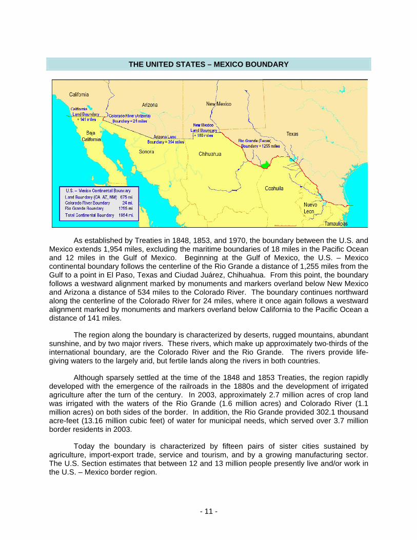
THE UNITED STATES – MEXICO BOUNDARY
As established by Treaties in 1848, 1853, and 1970, the boundary between the U.S. and Mexico extends 1,954 miles, excluding the maritime boundaries of 18 miles in the Pacific Ocean
nd 12 miles in the Gulf of Mexico. Beginning at the Gulf of Mexico, the U.S. – Mexico ontinental boundary follows the centerline of the Rio Grande a distance of 1,255 miles from the ulf to a point in El Paso, Texas and Ciudad Juárez, Chihuahua. From this point, the boundary
ment marked by monuments and markers overland below New Mexico nd Arizona iles to the Colorado River. The boundary continues northward
along the centerline of the Colorado River for 24 miles, where it o a westward rs overla
the boundary is characterize serts, rugged mountains, abundant unshine, and by two major rivers. These rivers, which make up approximately two-thirds of the ternational boundary, are the Colorado River and the Rio Grande. The rivers provide life-
giving waters to the largely arid, but fertile lands along the rivers in both countries.
Although sparsely settled at the time of the 1848 and 1853 Treaties, the region rapidly developed with the emergence of the railroads in the 1880s and the development of irrigated agriculture after the turn of the century. In 2003, approximately 2.7 million acres of crop land was irrigated with the waters of the Rio Grande (1.6 million acres) and Colorado River (1.1 million acres) on both sides of the border. In addition, the Rio Grande provided 302.1 thousand acre-feet (13.16 million cubic feet) of water for municipal needs, which served over 3.7 million border residents in 2003.
Today the boundary is characterized by fifteen pairs of sister cities sustained by agriculture, import-export trade, service and tourism, and by a growing manufacturing sector. The U.S. Section estimates that between 12 and 13 million people presently live and/or work in the U.S. – Mexico border region.
acGfollows a westward aligna a distance of 534 m
nce again follows alignment marked by monuments and markedistance of 141 miles.
The region along
nd below California to the Pacific Ocean a
d by desin
- 11 -
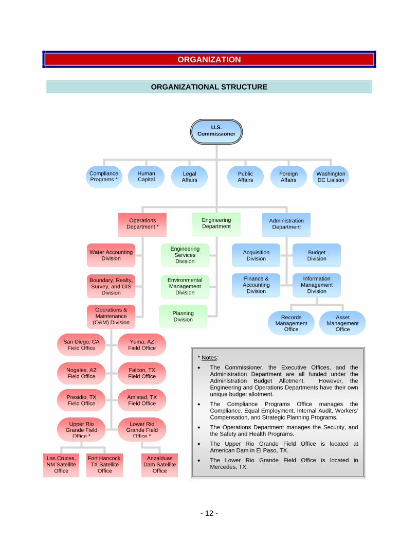
ORGANIZATION
ORGANIZATIONAL STRUCTURE
U.S. Commissioner
Compliance Programs *
Human Capital
Legal Affairs
Public Affairs
Foreign Affairs
Washington DC Liaison
Engineering Department
Operations Department *
Administration Department
Engineering Services Division
Environmental Management
Division
Acquisition Division
Budget Division
Finance & Accounting
Division
Information Management
Division
Water Accounting Division
Boundary, Realty, Survey, and GIS
Division
Operations & Maintenance
(O&M) Divisio
Planning Records Asset Division n Management Management
Office Office
San Diego, CA Field Office
Yuma, AZ Field Office
* Notes:
• The Commissioner, the Executive Offices, and the
the Safety and Health Programs.
Nogales, AZ Fi
Falcon, TX Administration Department are all funded under the Administration Budget Allotment. However, the Engineering and Operations Departments have their own unique budget allotment.
• The Compliance Programs Office manages the Compliance, Equal Employment, Internal Audit, Workers’ Compensation, and Strategic Planning Programs.
• The Operations Department manages the Security, and
eld Office
Upper Rio Grande Field
Office *
Amistad, TX Field Office
Presidio, TX Field Office
Field Office
Lower Rio Grande Field
Office *• The Upper Rio Grande Field Office is located at
American Dam in El Paso, TX.
• The Lower Rio Grande Field Office is located in Mercedes, TX.
Las Cruces, NM Satellite
Office
Anzalduas Dam Satellite
Office
Fort Hancock, TX Satellite
Office
- 12 -

OVERVIEW OF STRUCTURE ORGANIZATIONAL
The International Boundary and Water Commission (IBWC) is a binational organization, established to apply boundary ational agreements between the U.S. and Mexico. The IBWC Mexican Section. Each Section is administered independently of the other, and is headed by an Engineer Commissioner, who is appointed by his respective President. The U.S. Section receives foreign policy guidance from the U.S. Department of State, while the Mexican Section is administratively linked to the Secretariat of Foreign Relations of Mexico.
The U.S. Section and Mexican Section maintain their respective headquarters in the adjoining cities of El Paso, Texas and Ciudad Juárez, Chihuahua. Each Section maintains its own legal counsel, engineering staff, and administrative staff, and has field offices situated along the border to operate and maintain joint works. The Commissioner, two principal engineers, a legal adviser, and a secretary, designated by each Government as members of its Section, are entitled to the privileges and immunities appertaining to diplomatic officers. The Commission meets on a regular basis, alternating the place of meetings between the two countries and the staffs of the two Sections are in frequent contact.
The U.S. Section consists of the U.S. Commissioner, Executive Offices, and three Departments: Operations, Engineering, and Administration. The Executive Offices are comprised of the Compliance, Human Capital, Legal Affairs, Foreign Affairs, Washington DC Liaison, and Public Affairs Offices. The Operations and Engineering Departments carry out and address the core mission requirements of the U.S. Section. Like the Commissioner, the heads of the Engineering and Operations Departments are engineers. The Administration Department performs the necessary support functions for the agency, whereas the Executive Offices provide executive, legal, and foreign policy guidance to the Commissioner. The Heads of the Executive Offices and the three Departments make up the U.S. Section’s Executive Staff. The roles of the Executive Offices and Departments are summarized below.
EXECUTIVE OFFICES
and water treaties, and related internconsists of a U.S. Section and a
The Executive Offices are comprised of the Compliance, Human Capital, Legal Affairs, Public Affairs, Foreign Affairs, and the Washington, DC Liaison Offices. The Compliance Office administers the Compliance, Equal Employment, Internal Audit, Workers’ Compensation, and Strategic Planning Programs. Through its programs, the Compliance Office oversees agency policies and practices to ensure compliance with all respective laws, regulations, agency directives, and other requirements. In addition, the Compliance Office develops the Strategic Plan, formulates, documents, and measures performance goals, prepares annual plans and reports, and provides support during budget formulation and justification. The Human Capital Office is responsible for recruiting, maintaining and updating personnel information, analyzing positions, and administering employee benefit programs (retirement, insurance, etc.). The Office develops and implements policies, programs, and standards for effective management, utilization, and development of human resources in accordance with applicable laws, executive orders, rules and regulations. The Legal Affairs Office is the in-house counsel that provides all general legal services for the agency, including contracting, realty, employment, and environmental matters. It also provides legal guidance on bi-national issues, and interprets
- 13 -
international law as p olicy Program. The Foreign Affairs Office as an expert adviser on Tre
art of the implementation of the Agency’s Foreign Pis headed by the U.S. Section Secretary, who serves
aty and Minute interpretations, and, in cooperation with the Washington, DC Liaison Office at the Department of State, serves as a policy adviser on international relations. The Foreign Affairs Office also provides language interpretation services, maintains all diplomatic communication records, and prepares the formal binational agreements called IBWC Minutes. The Public Affairs Office responds to public concerns and coordinates citizen’s forums to inform and update the public about current and potential U.S. Section projects, initiatives, and issues. This office also prepares press releases, publications, brochures, and newsletters as needed.
THE OPERATIONS DEPARTMENT
The Operations Department is headed by the Principal Engineer of Operations. The Principal Engineer of Operations provides technical and policy advice to the U.S. Commissioner, and oversees all U.S. Section operations and maintenance activities to assure adherence with treaty requirements. The Operations Department consists of the following Division
THE E ENT
: Water Accounting, Planning and Integration, and Operations and Maintenance. The Operations and Maintenance Division, through its eight field offices, operates and maintains roughly 100 hydrologic gaging stations, 500 miles of levees, 20,000 acres of floodplains, four diversion dams, two International storage dams and associated hydroelectric power plants, over 500 hydraulic structures, two International wastewater treatment plants, and one-half of all boundary monuments and markers on the land boundary and at ports of entry. The Water Accounting Division coordinates and performs the water accounting functions to determine the national ownership of Rio Grande and Colorado River waters jointly with the Mexican Section. The Planning and Integration Division administers the security, safety and health, boundary and realty, graphic information systems, and project planning programs.
NGINEERING DEPARTM
The Engineering Department is headed by the Principal Engineer of Engineering. Like the Principal Engineer of Operations, the Principal Engineer of Engineering also provides technical and policy advice to the U.S. Commissioner. The Engineering Department provides technical support in engineering and environmental management to meet agency requirements. The Engineering Department conducts and reviews environmental impact studies, water quality monitoring, hydraulic studies, geotechnical investigations, and develops design plans and specifications for construction and renovation of buildings, hydraulic and flood control structures, hydroelectric power plant infrastructure, and wastewater treatment plant infrastructure.
THE ADMINISTRATION DEPARTMENT
The Administration Department is headed by the Chief Administrative Officer. It provides administrative support to all agency functions through its four Divisions: Acquisitions,
- 14 -
Budget, Finance and Accounting, and Information Management. The Administration Department will lead the way to implement the President's Management Agenda with the following action plans: (1) identifying potential improvements to eliminate superfluous or overlapping responsibilities in agency programs; (2) instituting an organizational structure that allows for a well coordinated and efficient organization that emphasizes public needs while meeting requirements and empowering employees; (3) developing a performance based budget process that evaluates the effectiveness of all activities to establish successful mission-oriented programs, determine funding requirements and identify efficiencies to eliminate mismanagement, waste, or duplication of efforts The Department is committed to helping its customers achieve desired results instead of placing impediments to progress. All this will be accomplished by placing utmost importance to achieving agency priorities, and the professional and personal development of each staff member.
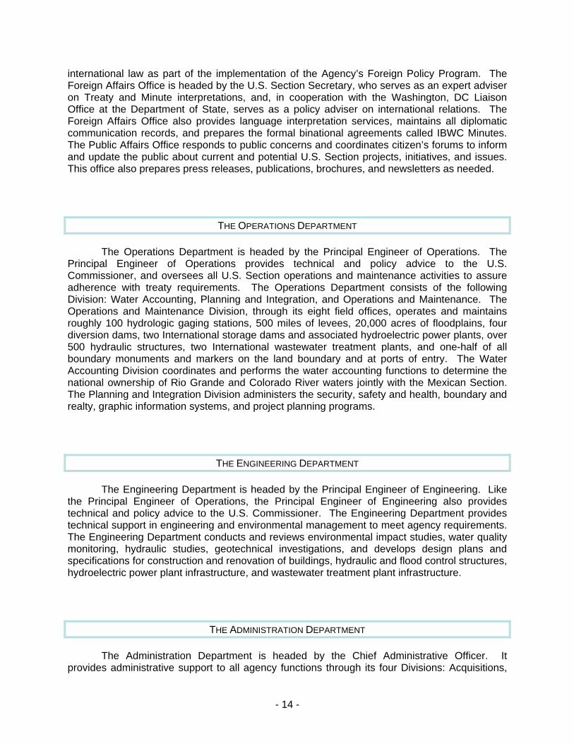
EMPLOYEE DISTRIBUTION
The U.S. Section employed an average total of 233 full-time personnel in FY 2007. Shown below is the average annual employee distribution by department, location, and funding source. These figures account for hire lag and consist of all U.S. Section personnel, including part-time employees.
Employee Distribution by Department
116
167
32
17
Executive Offices Human Capital
Administration Engineering
Operations
Employee Distribution by Location
7845
5
113
2333
30
5
Headquarters Amistad Dam & Power
American Dam Falcon Dam & Power
Presidio Field Office Mercedes Field Office
Yuma Field Office Nogales Field Office
San Diego Field Office
- 15 -
OFFICE LOCATIONS AND GENERAL RESPONSIBILITES
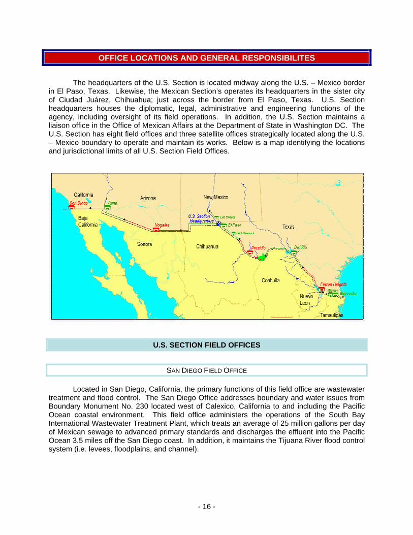
The headquarters of the U.S. Section is located midway along the U.S. – Mexico border in El Paso, Texas. Likewise, the Mexican Section’s operates its headquarters in the sister city of Ciudad Juárez, Chihuahua; just across the border from El Paso, Texas. U.S. Section headquarters houses the diplomatic, legal, administrative and engineering functions of the agency, including oversight of its field operations. In addition, the U.S. Section maintains a liaison office in the Office of Mexican Affairs at the Department of State in Washington DC. The U.S. Section has eight field offices and three satellite offices strategically located along the U.S. – Mexico boundary to operate and maintain its works. Below is a map identifying the locations and jurisdictional limits of all U.S. Section Field Offices.
U.S. SECTION FIELD OFFICES
SAN DIEGO FIELD OFFICE
Located in San Diego, California, the primary functions of this field office are wastewater eatment and flood control. The San Diego Office addresses boundary and water issues from
Boundary Monument No. 230 located west of Calexico, California to and including the Pacific cean coastal environment. This field office administers the operations of the South Bay
International Wastewater Treatment Plant, which treats an average of 25 million gallons per day f Mexican sewage to advanced primary standards and discharges the effluent into the Pacific
Ocean 3.5 miles off the San Diego coast. In addition, it maintains the Tijuana River flood control ystem (i.e. levees, floodplains, and channel).
tr
O
o
s
- 16 -

YUMA FIELD OFFICE
Situated in Yuma, Arizona, the jurisdiction of this field office extends from Boundary Monum
of the New River, and maintenance of land boundary monuments within their jurisdiction.
NOGALES FIELD OFFICE
ent No. 230 located west of Calexico, California to the Lukeville, Arizona International Port of Entry, which includes the 24-mile international stretch of the Colorado River. The Yuma Office works closely with the U.S. Bureau of Reclamation (USBR) to ensure the delivery and quality of Colorado River waters to Mexico in accordance with the 1944 Treaty and IBWC Minute No. 242. The field office performs water accounting activities, including maintenance of water gaging facilities, and conducts water quality assessments of Colorado River waters. The Yuma Office also works jointly with Mexico and the USBR to properly operate and maintain the international segment of Colorado River flood control system, which includes Morelos Dam. Other responsibilities include water quality assessments
Located in Nogales, Arizona, this office’s primary function is wastewater treatment. The City of Nogales, Arizona and the U.S. Section are co-owners of the Nogales International Wastewater Treatment Plant (NIWTP), which treats sewage from both countries. In addition to operating and maintaining the NIWTP, the Nogales Office maintains the land boundary monuments and addresses other transboundary water issues within their jurisdiction, which spans from the Lukeville, Arizona International Port Of Entry to the Arizona – New Mexico Stateline.
UPPER RIO GRANDE FIELD OFFICE
The Upper Rio Grande Field Office consists of a base station with two satellite offices. The primary office is situated along the Rio Grande at American Dam in El Paso, Texas. One satellite office is located in Las Cruces, New Mexico, approximately 40 miles north-northwest o
other is about 60 miles south-southeast in Fort Hancock, Texas. This eld office addresses the international boundary matters along New Mexico and all issues
concerning the Rio Grande from Caballo, New Mexico to the Presidio – Hudspeth – Jefferson Davis tri-county line in Texas. The primary functions of the Upper Rio Grande Field Office are
ensure the distribution of Rio Grande waters between Mexico and the U.S. in accordance with the Convention of 1906, and U.S. residents against Rio Grande floods. This is accomplished through the regular operation and maintenance of Americ
f American Dam, and thefi
to to provide flood protection to
an Dam and Canal, and an array of water gaging facilities and flood control works along this 197-mile stretch of the Rio Grande. This Upper Rio Grande Office occasionally provides assistance to other western region U.S. Section field offices to restore or repair structures or facilities.
- 17 -

P RESIDIO FIELD OFFICE
Situated in Presidio, Texas, the jurisdictional limits of this field office extends along the Rio Grande from the Presidio – Hudspeth – Jefferson Davis tri-county line to Heath Canyon immediately downstream of Big Bend National Park. The main purpose of the field office is to protect the town of Presidio, Texas by maintaining flood control works along a 15-mile stretch of the Rio Grande. Other responsibilities include preserving the international river boundary, collecting water quality samples, and performing water accounting activities, including operation and maintenance of water gaging facilities, along the Rio Grande within their jurisdiction.
AMISTAD DAM FIELD OFFICE
Located in Del Rio, Texas, the primary function of this field office is to effectively operate and maintain Amistad international storage dam and hydroelectric power plant. These operations provide electric power, flood control, and water conservation benefits to both the U.S. and Mexico. The field office also operates and/or maintains water gaging facilities, the bounda
FALCON DAM FIELD OFFICE
ry demarcation buoys on the reservoir, and performs water quality sampling and accounting of Rio Grande waters. The Amistad Dam Office addresses all Rio Grande boundary and water issues from Heath Canyon, just below Big Bend National Park, to the Maverick – Webb county line.
Like its upstream counterpart, the core role of this field office is to effectively operate and maintain the Falcon internation ower plant for welfare of the U.S. and Mexico. In conjunction with irrigation, municipal, and flood releases, the field office operate
al storage dam and hydroelectric p
s of the hydroelectric power plant and generates electricity. The field office also operates and/or maintains water gaging facilities, and performs water quality sampling and accounting of Rio Grande waters. The Falcon Dam Office is situated in Falcon Heights, Texas, and its jurisdiction extends between the Maverick – Webb county line and Rio Grande City, Texas.
LOWER RIO GRANDE FIELD OFFICE
The Lower Rio Grande Field Office consists of a base station and a satellite office. The primary office is located nearly 40 miles upstream of Brownsville, Texas in Mercedes, Texas. The satellite office is situated south of Mission, Texas at Anzalduas Dam. The primary functions of the Lower Rio Grande Office are to ensure the allocation of U.S. waters in accordance with 1944 Treaty and to protect south Texas residents from Rio Grande floods. This is accomplished through the regular operation and maintenance of Anzalduas and Retamal international dams, river and floodway gaging facilities, irrigation structures, and flood control works along the Rio Grande and its interior floodways from Peñitas to Brownsville, Texas. The office also performs water accounting and water quality sampling activities on the Rio Grande, oversight of Morillo drain operations in Mexico, and is responsible for all other Rio Grande boundary and water issues between Rio Grande City, Texas and the Gulf of Mexico.
- 18 -
STRATEGIC GOALS AND ACCOMPLISHMENTS
STRATEGIC GOAL 1 – BOUNDARY PRESERVATION
Preserve the U.S. – Mexico boundary, through binational cooperation, in accordance with international agreements.
The 1848 Treaty of Guadalupe Hidalgo, which ended the Mexican – American War, and the 1853 Gadsden Treaty establishe n the U.S. and Mexico. In addition, both Conventions e Commissions to designate and demarcate t
der populations increased during the 1900’s, the Commission installed 18 additional boundary monuments for a total of 276.
The 1944 Treaty expanded sibilities of the Commission and allocated the waters of the Rio Grande from Fort Quitman, Texas to the Gulf of Mexico and the Colorad
ing works to protect against bank erosion. The 1970 Treaty also provided procedures to avoid the loss of territory by either country incident to future changes in a river’s course.
IBWC Minute No. 24 provided for a permanent maintenance program for boundary monuments. Later July 1975, IBWC Minute No. 249 conclud
d the international boundary betweestablished temporary joint
he boundary line with ground landmarks. A binational survey and demarcation effort undertaken from 1849 to 1855 established the land boundary with 52 obelisk and stone mound monuments between the Pacific Ocean and the Rio Grande. The International Boundary Commission was established under the Convention of 1889 to apply the rules adopted under an 1884 Convention for resolving boundary issues resulting from the meandering of the Rio Grande and the Colorado River. It was made a permanent body in 1900. Pursuant to the 1882 Convention that addressed the land boundary, the Barlow – Blanco Survey resurveyed the borderline from 1891 to 1894 and increased the number of boundary monuments from 52 to 258. Later, as bor
the jurisdiction and respon
o River. The Convention of 1933 rectified the Rio Grande channel and provided a new river boundary between El Paso, Texas and Fort Quitman, Texas. The Chamizal Convention of 1963 relocated approximately 4.35 miles of the Rio Grande boundary to resolve boundary issues resulting from the southward movement of the river in the El Paso, Texas – Ciudad Juárez, Chihuahua Valley from 1852 to 1895. The 1970 Treaty, which superseded the 1884 Convention, resolved all pending boundary differences between the two countries, and provided for maintaining the Rio Grande and the Colorado River as the international boundary by authoriz
4, signed in December 1973, in
ed the boundary monumentation program by providing for smaller, intermediate concrete markers to be placed to better demarcate the international boundary. Records indicate that 442 markers were erected, mostly around areas experiencing population growth. IBWC Minute No. 302 in December 1999 provided for enhanced boundary demarcation at border ports of entry.
The 1970 Treaty mandated the delineation of the international boundary on maps or aerial mosaic photos for the Rio Grande and Colorado River Boundary. It also established the frequency to update these maps at intervals not greater than 10 years. IBWC Minute No. 278, dated March 1989, jointly approved the current boundary maps developed from photographic surveys conducted in 1982 and 1983.
- 19 -
ACCOMPLISHMENTS
During the past year, the U.S. Section continued its efforts to map and demarcate the international bounda Mexican Sections also worked together toGrande graphic Informati mission initiated the formal proce ally adopt the proposed Rio Grande boundary maps by issuing and approving a Joint Report of the Principal Engineers.
lcon International Dams and Reservoirs.
ry between the United States and Mexico. The U.S. and develop a final set of updated mosaic maps that delineate the Rio
boundary and include key landmark features. The agency utilized Geoon System (GIS) technology to develop the maps. Both Sections of the Com
ss of concluding a ne IBWC Minute to formw
The agency is also in the process of developing a similar set of aerial boundary maps for the Colorado River boundary. A draft set of Colorado River boundary maps was prepared by the U.S. Section and submitted to the Mexican Section for their review. A final set of approved maps is expected in FY 2010.
The U.S. Section, in collaboration with the Mexican Section, performed a Global Positioning Survey (GPS) to establish the precise geodetic locations of all 276 international land boundary monuments. In addition, the U.S. Section inspected all 138 of the U.S.-maintained land monuments and noted deficiencies. Of the 138 monuments, the agency found that only two monuments needed physical repair and 86 monuments needed repainting. The U.S. Section also performed the inspection and restoration of boundary demarcation markers at all U.S.-maintained border ports of entry, and inspected and maintained the buoys and markers that identify the jurisdictional line at Amistad and Fa
PLAN
The agency will develop and approve, via an IBWC Minute, a final set of mosaic boundary maps for the Colorado River boundary. The U.S. Section will develop and implement a five-year restoration plan for the eighty-eight U.S.-maintained land boundary monuments needing repair and repainting. Both Sections will work together to maintain all boundary plaques and pavement markers at all border ports of entry. The U.S. Section will continue to inspect and maintain the buoys and markers, which identify the jurisdictional line at Amistad and Falcon international reservoirs.
STRATEGIC GOAL 2 – WATER QUANTITY OPERATIONS
Provide flood protection to U.S. residents and ensure the efficient conveyance, utilization, and accounting of boundary and transboundary river waters through
the operation and maintenance of dams, reservoirs, power plants, and flood control projects in accordance with domestic law and international agreements.
The Convention of 1906 provided for the distribution of Rio Grande waters between the U.S. and Mexico in the international segment of the river from El Paso to Fort Quitman, Texas. Barring extraordinary drought or serious accident to the U.S. irrigation system, the U.S. agreed to deliver 60,000 acre-feet of water annually to Mexico at the Acequia Madre head works,
- 20 -
adjacent to the International Dam in facilitate compliance with the 1906 Convention, the U.S. Congress passed the Acts of August 29, 1935 and June 4, 1936. The 1935 A
one-thi
.S. In regards to the Colorado River, the U.S. agreed to provide an ann
nd flood control levees between El Paso and Fort Quitman. The 1944 Treaty and subsequent IBWC Minutes authorized the U.S. and Mexico to construct, operate and maintain works for storage and conveyance of water, flood contr stream gaging on the Tijuana and Colorado Rivers, and on the Rio Grande from Fort Quitman to the Gulf of Mexico. In addition, the treaty authori
ACCOMPLISHMENTS
El Paso, Texas. To
ct provided for the construction and operation of the American Dam and Canal for the purpose of diverting U.S. waters and releasing Mexican waters. The 1936 Act shortened the Rio Grande to reduce the conveyance losses of irrigation waters by straightening the channel between Caballo Storage Dam and American Dam.
The 1944 Treaty distributed the waters of the Colorado River, and the Rio Grande from Fort Quitman to the Gulf of Mexico. Under this Treaty, the U.S. was allotted all waters from the Pecos River, Devils River, and five other U.S. tributaries reaching the Rio Grande, as well as
rd of the flow reaching the Rio Grande from the Conchos River and five other named Mexican tributaries, provided that this third is not less than 1,750,000 acre-feet over a 5-year cycle (annual average of 350,000 acre-feet). The Treaty further provided one-half of the flows of the Rio Grande below the lowest storage dam, and one-half of the flows from the unmeasured tributaries to the U
ual volume of 1,500,000 acre-feet to Mexico, unless extraordinary drought or accident to the irrigation system in the U.S. make it difficult to deliver the guaranteed quantity. In years of surplus waters in excess of the amount necessary to supply uses in the U.S., the Treaty guarantees up to an additional 200,000 acre-feet to Mexico. The distribution of Tijuana River waters was not concluded between the two countries in the 1944 Treaty, but was to be subject to the study and investigation of the IBWC.
The Convention of 1933 not only provided for rectification of the Rio Grande, but also entrusted the IBWC with the construction, operation, and maintenance of river structures a
ol, and
zed the joint construction, operation, and maintenance of up to three large storage dams and hydroelectric power plants on the Rio Grande, two of which have been built. The 1970 Treaty requires the IBWC to maintain the conveyance of established normal flows and design flood flows by prohibiting obstructions within the international segments of the Rio Grande and Colorado River.
Throughout the period, the U.S. Secgaging stations a ansmit, compile, and account for the allocation of Rio Grande and Colorado River waters between the U.S. and Mexic and acco 906 and 19 2005 Colo
The U.S. Section continued its efforts to evaluate and improve deficient levee segments and as
the agency completed the design and award construction contracts for improvement of 92.7
tion regularly operated and maintained its hydrologic nd telemetry system equipment; used to collect, measure, tr
o. The U.S. Section collaborated with the Mexican Section to allocate, compute unt for the delivery of Rio Grande and Colorado River waters in accordance with the 1
44 Treaties. The agency published the 2005 Rio Grande Water Bulletin, and therado River and Western Boundary Streams Water Bulletin.
sociated structures in the Upper Rio Grande, Presidio, and Lower Rio Grande Flood Control Systems. The agency initiated the required environmental, engineering, and design work for improvement of 227 miles Upper and Lower Rio Grande flood control levees (106 miles in the Lower Rio Grande, and 121 miles in the Upper Rio Grande). Of the work commenced,
- 21 -
miles of levee in the Lower Rio Grande. In addition to levee improvement efforts, the agency maintained the capacities of its Rio Grande Flood Control Systems by mowing approximately 14,675 acres of floodplain and re-graded levees as needed. The Upper Rio Grande Flood Control System protects 1 million U.S. residents in the metropolitan statistical areas of Las Cruces, New Mexico and El Paso, Texas with its 225 miles of levees. The fifteen-mile long Presidio Valley Flood Control System provides flood protection to nearly 5000 people in Presidio, Texas. The Lower Rio Grande Flood Control System, with its 270 miles of river and interior floodway levees, protects one million U.S. residents in the following metropolitan statistical areas of Brownsville-Harlingen and McAllen-Edinburg-Mission in south Texas.
The agency continued its daily operation and maintenance of its diversion and storage dams, and hydroelectric power plants. Preliminary foundation and embankment studies were initiated by the IBWC to assess seepage problems and devise remedial measures at Amistad and Falcon International Storage Dams to circumvent potential structural failure. These studies are being performed by a panel of experts from both countries.
PLAN
The U.S. Section will continue to maintain its flood control levees, floodplains, and channels to ensure proper conveyance of river waters within the established flood control parameters. Levee maintenance will consist of
grading, spot repairs, and resurfacing. The U.S. Section will maintain its floodplains and channels through mowing and sediment removal activities. The agency will acquire the necessary permits and environmental documentation prior to commencing any of the silt removal activities.
The agency will continue to improve deficient levee segments and structures in the Upper Rio Grande, Presidio, and Lower Rio Grande Flood Control Systems. Deficient levee segments will be improved in order of priority by risk, population, and development. The U.S. Section will continue its close coordination with its stakeholders to address conveyance, storage and diversion issues concerning the waters of the Rio Grande, Colorado River, and Tijuana River.
STRATEGIC GOAL Y MANAGEMENT 3 – WATER QUALIT
Improve the quality of boundary and transboundary waters, in concert with Mexico, to address salinity and border sanitation problems pursuant to international agreements and applicable U.S. law.
The 1944 Treaty directed the IBWC to give preferential attention to the solution of all border sanitation problems concerning boundary and transboundary waters, and granted authority to provide any necessary sanitary measures or works to satisfy that requirement. Under IBWC Minute No. 261, dated September 1979, both governments agreed to identify border sanitation problems and solutions. This applied to waters crossing the border, including coastal waters, as well as those flowing along the Rio Grande and Colorado River boundary. Subsequent IBWC Minutes individually addressed specific border sanitation issues at many border communities including: San Diego/Tijuana, Calexico/Mexicali, Naco/Naco, Nogales/
- 22 -

Nogales, Del Rio/Ciudad Acuña, Eagle Pass/Piedras Negras, Laredo/Nuevo Laredo, Hidalgo/ Reynosa, and Brownsville/Matamoros.
In an effort to resolve the border sanitation problems in San Diego, California and Tijuana, Baja California, the IBWC concluded IBWC Minutes No. 270, 283 and 311. These Minutes provide the framework for treatment of sewage inflows from Tijuana, Mexico to U.S. secondary standards. The Tijuana River Valley Estuary and Beach Cleanup Act of 2000, further authorized the U.S. Section to provide secondary treatment of Tijuana sewage. The U.S. Section has constructed and is operating the advanced primary treatment facilities at the South Bay International Wastewater Treatment Plant (SBIWTP), and is currently developing options for sec
tly operates and maintains this plant in accordance with IBWC Minute No. 206. The IBWC later relocated the NIWTP to Rio Rico, Arizona as agreed upon under IBWC Minute No. 227. The NIWTP is co-owned by the City of Nogales, Arizona and IBWC.
ment Cooperation Commi
water quality issues at boundary and transboundary rivers and streams. IBWC Minutes No. 241 and 242 provided for measures to improve the quality of Colorado River water made available to Mexico at the Northerly International Boundary. Furthermore, the U.S. agreed in IBWC Minute No. 242 t ving an annual average salinity o e flow-weighted annual average salinity of Colorado River waters that arrive at Imperial Dam.
In an , the IBWC concluded Min cilitated the development of binational multi-phase and multi-agency efforts to characterize the extent of contamination within both countries’ shared water resources. The following studies were conduc
ondary treatment of the advanced primary effluent.
By authority of the 1944 Treaty, the IBWC constructed the Nogales International Wastewater Treatment Plant (NIWTP) in 1951 at Nogales, Arizona to address sewage treatment needs on both sides of border. The Commission join
The Commission agreed under IBWC Minute No. 279 to improve the quality of the Rio Grande waters at the sister cities of Laredo, Texas and Nuevo Laredo, Tamaulipas. This was accomplished through the joint construction of the Nuevo Laredo International Wastewater Treatment Plant (NLIWTP) at Nuevo Laredo, Tamaulipas, Mexico. IBWC Minute No. 297 provides the operation and maintenance obligations of both Sections.
In 1993, the U.S. and Mexico established the Border Environssion (BECC) and the North American Development Bank to assist states, localities, and
private entities in development of border environmental infrastructure projects. The IBWC agreed in IBWC Minute No. 299 to provide support to BECC for development of projects to resolve border sanitation issues.
The 1944 Treaty is the primary authority that grants the IBWC the right to address and resolve
o deliver flows to Mexico upstream of Morelos Dam haf no more than 115+/-30 parts per million U.S. count over th
effort to address growing water quality issues along the borderutes No. 279 and No. 289. The adoption of these Minutes fa
ted in the Rio Grande, Colorado River, and New River to identify the level of contamination in areas of concern such as expanding urban areas that depend on these water resources for multiple uses such as a domestic water supply, agriculture, and recreation.
• Binational Study Regarding the Intensive Monitoring of the Rio Grande Waters in the vicinity of Laredo/Nuevo Laredo Along the Boundary Portion Between the United States and Mexico (July 1997). A follow-up study was conducted after the
- 23 -

completion of the Nuevo Laredo International Wastewater Treatment Plant in November 2000.
• Binational Study Regarding the Presence of Toxic Substances in the Rio Grande/Rio Bravo and its Tributaries Along the Boundary Portion Between the United States and Mexico (1992), Second Phase (1997), Third Phase (1998).
• Binational Study Regarding the Presence of Toxic Substances in the Lower Colorado and New Rivers (1995).
The Texas Legislature passed the Texas Clean Rivers Act and established the Texas Clean Rivers Program in 1991. The goal of the program is to maintain and improve the quality of water within each riv
rogram for the Rio Grande Basin.
er basin in Texas through an ongoing partnership involving the Texas Commission on Environmental Quality, river authorities (program partners), other agencies, regional entities, local and state governments, industry, and citizens. The program uses a watershed management approach to identify and evaluate water quality issues, establish priorities for corrective actions, and work to implement those actions. Due to the international nature of the Rio Grande, the State of Texas contracted with the U.S. Section in October 1998 to administer the Texas Clean Rivers P
ACCOMPLISHMENTS
The U.S. Section continued its efforts to improve and sustain the water quality of boundary and transboundary rivers by collaborating with stakeholders to monitor, compile, and exchan
salinity issues on the Colorado River.
es was comple
PLAN
ge water quality data on the mouth of the Tijuana River (Pacific Ocean) and on the Rio Grande, Colorado, and New Rivers. In addition, the agency worked with stakeholders to develop and implement solutions to reduce the discharge of untreated wastewater into the New River. Both Sections conducted binational technical meetings and conducted a study to jointly evaluate water quality sampling, measurement and data collection procedures to address
During this year, the U.S. Section operated and maintained the South Bay International Wastewater Treatment Plant (SBIWTP) and Nogales International Wastewater Treatment Plant (NIWTP) on a daily basis to treat wastewater from Mexico and prevent unsanitary conditions along the border. The U.S. Section treated an average of 25 million gallons per day at the SBIWTP and 9.9 million gallons per day at the NIWTP. In an effort to improve the level of wastewater treatment and the quality of the effluent, the agency worked with stakeholders to upgrade the SBIWTP and NIWTP. Construction of the secondary treatment faciliti
ted at the NIWTP, and approximately 35% of the secondary treatment upgrade was completed at the SBIWTP. The U.S. Section also continues to provide technical assistance and financial support to the Mexican Section to ensure the proper operation and maintenance of the Nuevo Laredo International Wastewater Treatment Plant (NLIWTP), which discharges into the international reach of the Rio Grande.
Theexchange related tributaries. The agency will continue to operate and maintain the SBIWTP and NIWTP,
U.S. Section will continue to work with its stakeholders to monitor, compile, and water quality data along the Rio Grande, Colorado, Tijuana and New Rivers and
- 24 -

and providLastly, the agency plans to complete construction of the secondary treatment upgrades at the SBIWT aSBIWT
e support to the Mexican Section for operation and maintenance of the NLIWTP.
P, nd design and construction administration buildings to support plant operations at P and NIWTP.
STRATEGIC GOAL 4 – RESOURCE AND ASSET MANAGEMENT
Maximize organizational effectiveness through innovative management and accountability of human, physical, and fiscal resources.
To ensure that scarce public resources are wisely invested, federal agencies must manage their allocated resources and portfolio of capital assets in the most effective and efficient manner possible. Agencies must follow a capital programming process that integrates the planning, acquisition, and management of capital assets into the budget decision-making process. Capital programming is intended to assist agencies in improving asset management and in complying with all mandatory and regulatory requirements.
In today’s world, agencies mus ults-oriented Acts. Some of the most commonly referenced include:
ct of 1995
ancial results of actions taken, control over the Federal Government's financial resources, and protection of Federal assets. The Energy Policy Act requires each federal agency to reduce their dependence on petroleum products and install, to the maximum extent practicable, all energy ater conservation measures with payback periods of less than 10 years in U.S. government owned buildings. The Paperwork Reduction Act dire
t abide by many res
• The Government Performance and Results Act of 1993 • The Federal Managers Financial Integrity Act of 1982 • Chief Financial Officers Act of 1990 • Federal Financial Management Improvement Act of 1996 • The Energy Policy Act of 1992 • The Paperwork Reduction A• The Clinger-Cohen Act of 1996 • The Federal Acquisition Streamlining Act of 1994, Title V (FASA V) • The Federal Information Security Management Act • The E-Government Act of 2002 (P.L. 107–347)
For example, the Government Performance and Results Act establishes the foundation for federal agencies to be successful, by creating a performance planning and accountability process in which agencies clarify their mission, develop goals, measure performance, and submit annual progress reports. The Federal Managers Financial Integrity Act, Chief Financial Officers Act, and the Federal Financial Management Improvement Act require accountability of financial and program managers for fin
and w
cts agencies to perform their information resource management activities in an efficient, effective, and economical manner. The Clinger-Cohen Act mandates agencies to use a disciplined capital planning and investment control process to acquire, use, maintain and
- 25 -

dispose of information technology. The Federal Acquisition Streamlining Act, Title V requires agencies to establish cost, schedule and measurable performance goals for all major acquisition programs, and achieve on average 90 percent of those goals. The Federal Information Security Management Act directs agencies to integrate IT security into their capital planning and enterprise architecture processes, conduct annual IT security reviews of all programs and systems, and report the results of those reviews to OMB. The E-Government Act mandates agencies to develop performance measures and implement initiatives utilizing Internet-based technology to e citizen-to-government communications. The Act also requires agencies to support government-wide E-Gov initia
Federal ment Agenda (PMA). The PMA, which was initially announced in the summer of 2001, is an aggressive strateg
ply. Many requirements are direct, while others indirect. For instanc ell as contractors, follow Occupation lations. Agencies are also obligate to ust apply the requirements set forth in of 1969 (NEPA) to any action involving federal resourc le requirements, and keep the pub a its intentions and progress.
MPLISHMENTS
improve customer service, save taxpayer dollars, and streamlin
tives and to leverage cross-agency opportunities to further E-Gov.
agencies are obligated to comply with the President's Manage
y for improving the management of the Federal government. The President has envisioned an active, but limited, government that focuses on priorities, and the PMA is the starting point for management reform. It focuses on five areas of management weakness across the government where improvements and the most progress can be made. These five major areas focus on Strategic Management of Human Capital, Competitive Sourcing, Improved Financial Performance, Expanded Electronic Government, and Budget and Performance Integration.
There are also numerous laws, regulations, executive orders, and other mandates with which federal agencies must com
e, agencies must ensure that their employees, as wal Safety and Health Administration (OSHA) regu
d operate in an environmentally friendly manner, and m the National Environmental Policy Act es or assets. The U.S. Section will comply with all applicablic nd its stakeholders informed of
ACCO
The U.S. Section continued developing policy and implementing the necessary measu The agency made improvements its Information Technology (IT) network to increase the security of information, and also developed a Cont
res to meet new and updated federal mandates.
inuity of Operations Plan (COOP) in the event of a Pandemic. In addition, it conducted annual inventories to properly identify and document accountable property.
The agency continued its coordination and information exchange with stakeholders by conducting periodic Citizens’ Forums at each of five regional areas (San Diego, Lower Colorado River, Southeastern Arizona, El Paso/Las Cruces, Lower Rio Grande Valley). The U.S. Section will held Commission meetings with the Mexican Section on a recurring basis (usually every 4 to 8 weeks) to surface binational concerns, address issues, and resolve problems, and sent regular reports (typically every 2 to 8 weeks) to the U.S. Department of State. Both Sections concluded an IBWC Minute.
The U.S. Section prepared and implemented an annual audit plan focusing on meeting compliance requirements for property and equipment, deferred maintenance, and ARRA related activities. The agency addressed various legal issues, and produced and submitted all annual compliance reports.
- 26 -
PLAN
The U.S. Section will continue to address all legal and compliance related issues, and submit required compliance reports. The agency will implement a streamlined approach that simplifies and shortens the application process to comply with the Hiring Reform Act. It will also upgrade its current network and email systems to improve data transmission rates and establish an interoperable collaborative solution for information sharing with stakeholders. The agency will improve emergency response planning by utilizing GIS to develop flood inundation maps of Amistad and Falcon Dams under various scenarios.
The U.S. Section will continue to increase public awareness and involvement by conducting periodic Citizens’ Forum meetings. It will also continue to surface binational concerns, address issues, and resolve problems with the Mexican Section by conducting Commission meetings on a regularly. The agency will improve collaboration with its stakeholders by conducting a binational summit to evaluate the planning and effectiveness of sanitation projects along the U.S. – Mexico border region.
- 27 -

FINANCE
The Office of Management and Budget (OMB), in conjunction with the Chief Financial Officers (CFO) Council, provides the guidelines for financial reporting in OMB Circular A-136, Financial Reporting Requirements. OMB Circular A-136 is the central reference point for Executive Branch agencies that are required to submit audited financial statements.
The U.S. General Accounting Office requires the U.S. Section to prepare and submit audited financial statements for inclusion into the Department of State’s Financial Audit Report. The U.S. Section prepares its financial statements in accordance with the accounting standards promulgated by the Federal Accounting Standards Advisory Board (FASAB). These statements are audited by the Department of State’s financial accounting firm of Leonard G. Birnbaum and Company, LLP.
FINANCIAL HIGHLIGHTS
Assets & Liabilities % Change Net Change FY 2008 FY 2009
AssetsFund Balance with Treasury 155.3% $204,326 $131,560 $335,886Accounts Receivable -27.1% ($631) $2,331 $1,700Land 0.0% $0 $50,028 $50,028Structures 0.0% $0 $380,422 $380,422Equipment 8.5% $1,299 $15,211 $16,510Construction in Progress 317.4% $59,403 $18,714 $78,117Accumulated Depreciation 5.4% ($9,474) ($176,603) ($186,077)Other Monetary Assets -100.0% ($84) $84 $0
Total Assets 60.4% $254,839 $421,747 $676,586
LiabilitiesAccrued Payroll 7.4% $74 $995 $1,069Accrued Workers' Compensation -12.4% ($117) $940 $823Workers' Compensation Actuarial 15.0% $365 $2,437 $2,802Accrued Annual Leave 10.2% $132 $1,296 $1,428Contingent/Environmental Liabilities -29.9% ($26,214) $87,692 $61,478Other Liabilities 16.8% $730 $4,344 $5,074
Total Liabilities -25.6% ($25,030) $97,704 $72,674
- 28 -

OVERVIEW OF FINANCIAL POSITION
ASSETS
The U.S. Section had total assets of $676.5 million at the year end in FY 2009, which is $254.8 million more than in FY 2008. The increase is due the receipt of $220 million in recovery funds and $43.2 million in construction funds during FY 2009. Fund Balance with Treasury increased during
LIABILITIES
the period by $204 million and Construction in Progress increase by $59.4 million to $78.1 million. The increase in Construction in Progress is the result of the work that was done on the Rio Grande River levees and the construction of the South Bay Secondary Treatment Plant in San Ysidro, California.
Assets by Type
11.5%
0.3%
49.6%0.00%
38.6%
As reported on the Consolidated Balance Sheet, the U.S. Section had total liabilities of $72.6 million at the end of FY 2009. The largest component of the agency’s outstanding liabilities at year-end was the $61.4 million Environmental Liability established for the agency to achieve full compliance with effluent discharge standards by providing for secondary treatment of Mexican wastewater from Tijuana, Baja California. The Environmental Liability was restated for FY 2008 from $381.4 million to $87.7 million as a result of the completion of work done on the Nogales Upgrade and a revision of the South Bay secondary treatment plant estimate. In FY 2009, the Accrued Annual Leave Liability increased by $132K and the Workers’ Compensation Actuarial Liability increase by $365k.
Fund Balances with Treasury
Accounts Receivable
Property and Equipment
Construction in Progress
Other Monetary Assets
Liabilities by Type
7.0%
5.0%2.0% 1.47%
84.6% Annual Leave
Workmans Compensation
Environmental Liabilities
Other Liabilities
Payroll
- 29 -
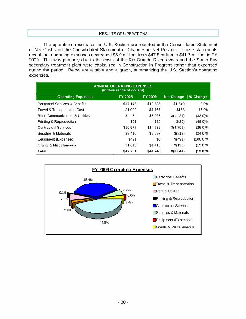
RESULTS OF OPERATIONS
The operations results for the U.S. Section are reported in the Consolidated Statement of Net Cost, and the Consolidated Statement of Changes in Net Position. These statements reveal that operating expenses decreased $6.0 million, from $47.8 million to $41.7 million, in FY 2009. This was primarily due to the costs of the Rio Grande River levees and the South Bay secondary treatment plant were capitalized in Construction in Progress rather than expensed during the period. Below are a table and a graph, summarizing the U.S. Section’s operating expenses.
ANNUAL OPERATING EXPENSES (in thousands of dollars)
Operating Expenses FY 2008 FY 2009 Net Change % Change
Personnel Services & Benefits $17,146 $18,686 $1,540 9.0%Travel & Transportation Cost $1,009 $1,167 $158 16.0%Rent, Communication, & Utilities $4,484 $3,063 $(1,421) (32.0)%Printing & Reproduction $51 $26 $(25) (49.0)%Contractual Services $19,577 $14,786 $(4,791) (25.0)%Supplies & Materials $3,410 $2,597 $(813) (24.0)%Equ xpensed) $491 $0 $(491) (100.0)%Grants & Miscellaneous $1,613 $1,415 $(198) (13.0)%Tot $47,781 $41,740 $(6,041) (13.0)%
ipment (E
al
FY 2009 O pensesperating ExPersonnel Benefits
7.3%
35.4%
44.8%
2.8%
0.1%
3.4%
0.0%6.2%
Travel & Transportation
Rent & Utilities
Printing & Reproduction
Contractual Services
Supplies & Materials
Equipment (Expensed)
Grants & Miscellaneous
- 30 -
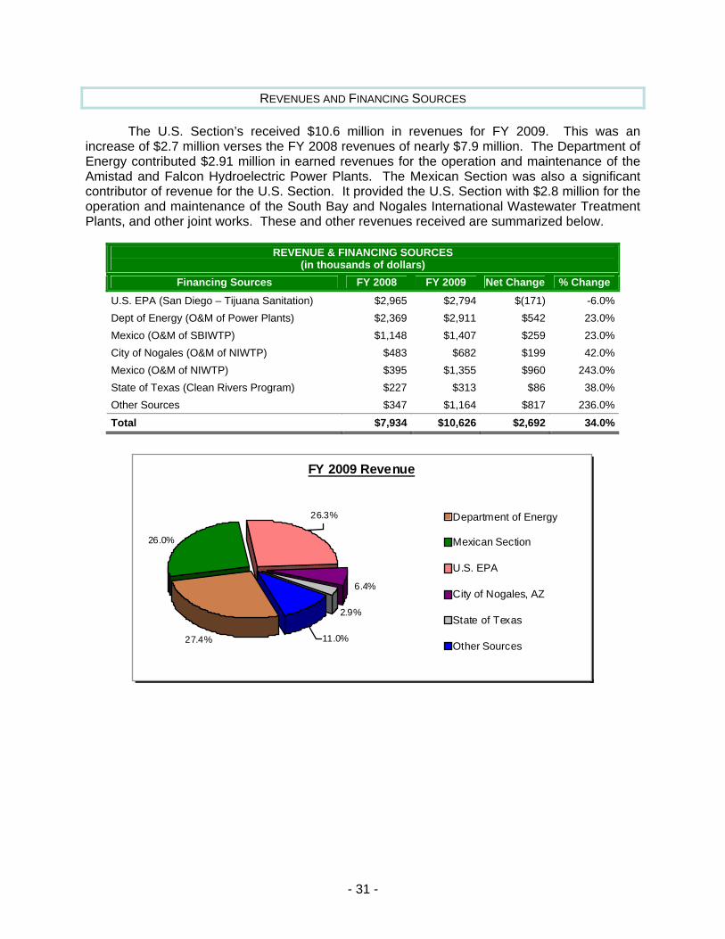
REVE CES NUES AND FINANCING SOUR
The U.S. Section’s received $10.6 million in revenues for FY 2009. This was an increase of $2.7 million verses the FY 2008 revenues of nearly $7.9 million. The Department of Energy contributed $2.91 million in earned revenues for the operation and maintenance of the Amistad and Falcon Hydroelectric Power Plants. The Mexican Section was also a significant contributor of revenue for the U.S. Section. It provided the U.S. Section with $2.8 million for the operation and maintenance of the South Bay and Nogales International Wastewater Treatment Plants, and other joint works. These and other revenues received are summarized below.
REVENUE & FINANCING SOURCES (in thousands of dollars)
Financing Sources FY 2008 FY 2009 Net Change % Change U.S. EPA (San Diego – Tijuana Sanitation) $2,965 $2,794 $(171) -6.0%Dept of Energy (O&M of Power Plants)
P) P)
ers Program) $1,
$2,369 $2,911 $542 23.0%Mexico (O&M of SBIWTP) $1,148 $1,407 $259 23.0%City of Nogales (O&M of NIWT $483 $682 $199 42.0%Mexico (O&M of NIWT $395 $1,355 $960 243.0%State of Texas (Clean Riv $227 $313 $86 38.0%Other Sources $347 164 $817 236.0%
Total $7,934 $10,626 $2,692 34.0%
FY 2009 Revenue
26.3%
2.9%
27.4%
26.0%
6.4%
11.0%
Department of Energy
Mexican Section
U.S. EPA
City of Nogales, AZ
State of Texas
Other Sources
- 31 -

PR S INCIPAL FINANCIAL STATEMENT
The Principal Financial Statements have been prepared to report the financial position and results of operations of the International Boundary and Water Commission, U.S. Section. The Financial Statements have been prepared from the books and records of the Commission in accordance with formats prescribed by the Office of Management and Budget (OMB) in OMB Circular A-136, Financial Reporting Requirements. The Financial Statements are in addition to financial reports prepared by the Commission in accordance with OMB and U.S. Department of Treasury directives to monitor and control the status and use of budgetary resources, which are prepared from the same books and records. The Financial Statements should be read with the understanding that they are for a component of the U.S. Government, a sovereign entity. The Commission has no authority to pay y budgetary resources. Liquidation of such liabilitie ent of an a tion in sent data ative form
liabilities not covered bs requires enactm ppropria . The F ancial Statements pre
for FY 2009 and FY 2008 in compar ats.
- 32 -
INTERNAL CONTR D REGULATIONS OLS AND COMPLIANCE WITH LAWS AN
The In
In compliance with the FMFIA requirements, the International Boundary and Water Commission conducted an annual assessment if its system of internal controls and financial management ystems. All agency managers conducted reviews of the internal controls within their respective
functional areas of responsibility. In addition, internal management reviews and OIG audit ports were reviewed and followed-up on to ensure corrective actions were taken for all
identified weaknesses. Based on the results of the annual assessment of the agency’s system f internal controls, the Commissioner issued a statement that the system of management
effect for FY 2009 provide reasonable assurance that the management control bjectives were achieved. The management controls over financial reporting were also
d and the Commissioner issued a statement that the controls were operating effectively nd no material weaknesses were found. The agency made significant progress in correcting
some of the deficiencies that the OIG auditors identified during the FY 2008 audit. The agency completed physical inventories of all accountable personal property at its headquarters as well as at all field office locations. Corrective actions were also initiated in the reporting of Deferred Maintenance.
ternational Boundary and Water Commission’s management is responsible for establishing and maintaining an effective internal control to achieve the objectives of effective and efficient operations, reliable financial reporting, and compliance with applicable laws and regulations. The Federal Managers’ Financial Integrity Act (FMFIA) establishes overall requirements with regard to internal control. Controls must be established that reasonably ensure that obligations and costs are in compliance with applicable laws; funds, property, and other assets are safeguarded against waste, loss, unauthorized use or misappropriation; and revenues and expenditures applicable to agency operations are properly recorded and accounted for to permit the preparation of accounts and reliable financial and statistical reports and to maintain accountability over the assets. An annual evaluation of the controls and financial systems must be conducted and a report submitted to ensure that objectives of FMFIA are being met.
s
re
ocontrols in oassessea
- 33 -