international journal of coal geology · 2017-05-09 · geological and hydrogeological controls on...
TRANSCRIPT

International Journal of Coal Geology 121 (2014) 148–159
Contents lists available at ScienceDirect
International Journal of Coal Geology
j ourna l homepage: www.e lsev ie r .com/ locate / i j coa lgeo
Geological and hydrogeological controls on the accumulation of coalbedmethane in the Weibei field, southeastern Ordos Basin
Yanbin Yao ⁎, Dameng Liu, Taotao YanCoal Reservoir Laboratory of National Engineering Research Center of CBM Development & Utilization, China University of Geosciences, Beijing 100083, PR China
⁎ Corresponding author. Fax: +86 10 82326850.E-mail address: [email protected] (Y. Yao).
0166-5162/$ – see front matter © 2013 Elsevier B.V. All rihttp://dx.doi.org/10.1016/j.coal.2013.11.006
a b s t r a c t
a r t i c l e i n f oArticle history:Received 12 August 2013Received in revised form 8 November 2013Accepted 8 November 2013Available online 14 November 2013
Keywords:Coalbed methane (CBM)Gas accumulationHydrogeologyOrdos BasinWeibei field
Commercial exploration and production of coalbed methane (CBM) in the Weibei field, Ordos Basin, China hasrapidly increased since 2010. The Weibei field has become one of the most productive CBM areas in China.However, relatively few studies have investigated the migration of gas and water in the coal reservoir andtheir controls on the gas accumulation. This study conducts stable isotope analyses and quality tests for ground-water samples, discusses the relationships between the fluid flow pathways and tectonics, and concludes bydiscussing the geological and hydrological controls on potential gas accumulation in the Weibei field.The coalbed groundwaters contain primarily sodium and bicarbonate and are effectively devoid of sulfate, calci-um andmagnesium. The groundwaters are typically freshwater, with total dissolved solids (TDS) values rangingfrom 814 to 2657 mg/L. Differences in hydrogeology and structural geology divide the study area into four gasdomains. In the northern Hancheng area, the predominant northwest flow of groundwater has resulted in highergas content in thewest (N12 m3/t) than in the east (8–12 m3/t), even though the coals in the east have high ther-mal maturity (2.1%–2.3% Ro). The area with the highest gas content (N16 m3/t) is in the region near thedownthrown side of the Xuefeng–Nan Thrust Fault in the northern Hancheng area, and the fault forms a barrierto the northwestward flow of groundwater. The area with the lowest gas content (b4 m3/t) is in the southwestHeyang area, where there is no entrapment mechanism and the gas has been flushed out of the coals due to areduction of hydrostatic pressure and active groundwater flow from the east. Structural and hydrodynamicmechanisms, especially the intensity of the hydrodynamic activity and the groundwater flow pathways, areimportant for gas accumulation in the Weibei field.
© 2013 Elsevier B.V. All rights reserved.
1. Introduction
TheOrdos Basin is one of themost important fossil-fuel energy prov-inces in west-central China and contains large reserves of coal, oil andnatural gas, and coalbed methane (CBM). Commercial production ofCBM in the basin began in 2010 at the Weibei field. The Weibei fieldlies in the southeast part of the Ordos Basin (Fig. 1), where explorationand production of CBM has rapidly increased during the past severalyears. A total of 1358 CBM wells had been drilled, and 383 wells areproducing by the end of the May of 2013.
Gas accumulation in coal reservoirs is a synergistic interplaybetween the distribution of coal, coal rank, gas content, permeability,depositional setting, structural setting, and groundwater flow, the latterof which may be most important in some basins (Kaiser et al., 1994).Based on an experimental and mathematical simulation, Qin et al.(2006) proposed a carbon isotope fractionation mechanism: theflowing groundwater takes away dissolved gas in coal seams, thenfree gas exchanges with absorbed gas, and the cycle continues. Finallygroundwater takes much more methane. This model explains how the
ghts reserved.
groundwater flow influence the methane transport and as well as thechanges of gas content and gas isotopic composition in a reservoir. Re-cently, a geostatistical simulation study by Karacan and Goodman(2012) also indicated that groundwater plays an important role in themigration of methane; moreover, migration can occur in the wholecoal-bearing strata. Scott (2002) reviewed major hydrogeologicalfactors that affect the distribution of gas content in several CBM basinsin the USA. Van Voast (2003) demonstrated that the geochemical signa-ture of formation waters is an effective exploration tool in evaluatingprospects and choices of exploration targets in six principal CBM-producing basins in the United States.
Hydrogeology affects gas generation, coal properties, reservoir con-ditions, and the regional distribution of gas content. Meteoric rechargeis important for the accumulation of CBM that has a biogenic origin(Flores et al., 2008) because meteoric water can transport microbesthat are responsible for the secondary biogenesis of methane. Thissituation was found in the San Juan Basin (Ayers, 2002), the PowderRiver Basin (Flores et al., 2008; Rice et al., 2008) and east-central Utah(Lamarre, 2003). Moreover, the migration of groundwater is importantfor the accumulation of thermogenic gases in coal seams. The gas con-tent of thermogenic gases is increased where hydrodynamic trappingof CBM occurs (Scott, 2002). This process is found in east-central Utah

Fig. 1. Location map of the Weibei field. Hypsography and sampling locations of CBM wells are shown.
149Y. Yao et al. / International Journal of Coal Geology 121 (2014) 148–159
(Lamarre, 2003), the northeastern Greater Green River Basin (Scott,2002), the San Juan Basin (Ayers, 2002; Scott et al., 1994), the south-eastern Qinshui Basin (Cai et al., 2011; Song et al., 2012), and the south-western Ordos Basin (Xu et al., 2012). However, the gas content ofthermogenic gases decreases in areas of active recharge with down-ward flow potential and/or convergent flow where there is no mecha-nism for entrapment, as in Great Britain (Ayers et al., 1993) andeast-central Utah (Lamarre, 2003).
Hydrology is also a key control on the fluid pressure regime (Bachuand Michael, 2003) and the production rates of gas and water in CBMreservoirs (Ayers, 2002; Kaiser et al., 1994). Pashin (2007) reported theinfluences of hydrodynamics on reservoir performance in the BlackWarrior Basin, and Kinnon et al. (2010) demonstrated that a fault actsas a barrier to water and gas flow in the Bowen Basin, Australia.
Our understanding of the controls on gas accumulation is based oncomprehensive geological and hydrological studies of the southeasternOrdos Basin that have been carried out since 2002 but have largely beenunreported in the international literature. We performed a preliminaryevaluation of CBMproduction potential and its geological controls in theWeibei coal field (Yao et al., 2009) and performed additional research
about the origin of the gas, the gas properties and the reservoir charac-teristics of theWeibei field (Yao et al., 2013). Our previouswork also de-veloped conceptual models of gas accumulation (Yao et al., 2013).However, the research on the migration of gas and water in the fieldand their controls on the gas content have not been reported. Thisstudy presents stable water isotope analyses (δDH2O and δ18OH2O) andwater quality analyses for produced groundwater, discusses the rela-tionships between fluid flow pathways and tectonics, and examinesthe geological and hydrological controls on the accumulation of CBMin the Weibei field.
2. Geological setting and hydrogeology
2.1. Structures
The Weibei field is located in the northeastern part of the Weibeiuplift in the southeastern Ordos Basin (Yao et al., 2009). The fieldextends across Hancheng City and Heyang City in Shanxi Province andcovers an area of approximately 1530 km2 (Fig. 1).

150 Y. Yao et al. / International Journal of Coal Geology 121 (2014) 148–159
The study area is divided into two parts: the Hancheng area in thenorth and the Heyang area in the south (Fig. 2). The study area containsa west-dipping monocline in the Hancheng area and north-dippingmonocline in the Heyang area, which are illustrated in the structurecontour map of the No. 5 coal seam (Fig. 2). Three major thrust faults,including the Xuefeng–Bei (F1), Xuefeng–Nan (F2) and Qiangao (F3)Faults (Fig. 3), and numerous small-scale NW–SE-striking faults arepresent in the area. The small-scale faults include the thrust faultswithin the study area and several normal faults in the Heyang area. Anin-depth discussion of the tectonics and structural geology of thestudy area is provided by Yao et al. (2013).
2.2. Hydrology
The surface topography of the study area includes hills in the north-west region, plains in the east and south, and many southeast-trendingvalleys (Fig. 1). Meteoric water flows along the valleys to the YellowRiver in the east part of the study area (Fig. 1). The Yellow River is thelargest river in the region and flows from north to south along theeastern margin of the study area (Fig. 1). The river has a mean flowrate of 6328 m3/s (Dai, 2010). The climate of the study area is continen-tal semi-arid, with an average annual precipitation of 500 mm and anannual evaporation of approximately 1500–2000 mm (Dai, 2010). Theprecipitation recharge outcrops is above the river valley. Only in theflood season, groundwater can be recharged by the Yellow River.
CBM is produced from coals in the Carboniferous Taiyuan Formationand the Permian Shanxi Formation (Fig. 4). The depositional environ-ments of the Taiyuan and Shanxi Formations are characterized byextensive tidal flat and shallow marine facies and extensive deltaic andlacustrine environments (Yao et al., 2013). The coal-bearing stratamain-ly consist of fine-grained sandstones, shale, coal and some carbonatesand are overlain by shales and shaly sandstones in the Permian Shihezi
Fig. 2. The structural elevation of the bottom of the No. 5 coal seam in the Weibei field. Majo
and Shiqianfeng Formations (Fig. 4). In the study area, most of theMeso-zoic strata and all of the Cenozoic strata have been eroded during basinuplift. The upper Permian Shiqianfeng Formation is preserved only inlocal areas. The underlying formations include the Permian Benxi Forma-tion and the Ordovician Fengfeng Formation. The Benxi Formation,which is mainly composed of shales and claystones, unconformablyoverlies the marine carbonates of the Fengfeng Formation (Fig. 4).
The hydrogeology is poorly understood in the areas of CBMdevelop-ment, although some previous work has focused on the eastern marginof the study area (Dai, 2010), where coal mining has taken place.According to Dai (2010), there are three separate aquifer systems;from top to bottom, these include the Quaternary (Q), Carboniferous–Permian (C–P) and Ordovician (O) aquifers (Fig. 4).
The Q aquifer is a shallow aquifer system with topography drivenflow. Recharge areas are in the high surface topography in the west, anddischarge areas are to the east and southeast. It contains little water, haslow permeability and has little influence on the coal-bearing strata.
The C–P aquifer is the main source of produced water from CBMwells. Groundwater generally infiltrates through sandstones, carbon-ates and coals within the C–P strata (Fig. 4). Generally, the C–P strataare defined as a whole aquifer, while in certain situations they are alsodivided into two sub-aquifers: the Shanxi Formation and the TaiyuanFormation aquifers. According to the CBM production practices byChina National Petroleum Corporation (CNPC), the Taiyuan Formationaquifer has a much more important influence on the production ofCBM than the Shanxi Formation aquifer in the Weibei field.
The O aquifer produces water readily and has relatively high perme-ability. Groundwater in the aquifer flows through water-eroded cavesand fractures in the carbonate rocks from east to west (Dai, 2010).Vertically, the Ordovician aquifer is isolated from the coal-bearing strataby the shales of Benxi Formation (Fig. 4). Therefore, it has little influenceon CBM production unless the Ordovician formations are drilled by in-correct operations.
r thrust faults include the Xuefeng–Bei (F1), Xuefeng–Nan (F2) and Qiangao (F3) Faults.

Fig. 3. Structural cross section of the strata in the Weibei field. See Fig. 2 for location of cross section.
151Y. Yao et al. / International Journal of Coal Geology 121 (2014) 148–159
2.3. Coal seams for CBM production
The representative stratigraphic column and sedimentary cross sec-tion of the Taiyuan and Shanxi Formations are shown in Fig. 5. The prin-cipal targets for CBM development are coal seams Nos. 5 and 11 in theTaiyuan Formation. Locally, CBM can also be recovered from coal seamNo. 3 in the Shanxi Formation. The three coal seams are adjacent toeach other and are separated by b30 m. Results from explorationwells indicate that the distance from the top of the No. 3 to the bottomof the No. 11 is commonly 60–80 m in the study area (Fig. 5). The coalrank in the study area ranges from low-volatile bituminous to semi-anthracite (Yao et al., 2013).
Of the three coal seams, theNo. 3 coal seam is the thinnest, with a typ-ical thickness of 1–3 m. The No. 5 coal seam is thick and continuous, withthe thickness of 3–5 m in the Heyang area and 3–8 m in the Hancheng
Fig. 4. Delineation of the characteristics of stratigraphy and hydrostratigraphy in theWeibei field. The Benxi Formation unconformably overlies the Fengfeng Formation asindicated by the dashed line.
area. The No. 11 coal seam commonly has a thickness of 2–8 m in theHancheng area, and it thins southeastward to less than 1 m in the easternHeyang area.
In the Weibei field, the CBM production wells generally have multi-ple perforations that target one or several coal seams. These wells typi-cally target only the No. 5 and No. 11, or the multiple layers of Nos.3 + 5, Nos. 5 + 11, and Nos. 3 + 5 + 11. For a tentative purpose,some wells target both a coal seam and the overlying sandstone layer,e.g. the well H6 (Table 1).
3. Experiments and method
3.1. Samples
Samples of co-produced water were collected from fourteen explo-rationwells in theWeibei field (Fig. 1). These wells were being pumped24 h per day to dewater the coal seams, so the water in the well borewas constantly being replaced. Meanwhile, all selected wells had beenpumped for N420 days as of the time of sampling, avoiding contamina-tion of the groundwater samples by drilling fluid. Water was collecteddirectly from the well head by attaching tygon tubing to a port onthe well head tee. While collecting the samples, special precautionswere taken to ensure that the sampled water was not artificiallycontaminated.
The collected groundwater samples were produced from the Nos. 3,5 and 11 coal seams and the sandstone seam at the top of the No. 3 coalseam. Detailed geological information and the production performanceof selected exploration wells are given in Table 1.
3.2. Experiments and method
The groundwater samples were filtered and analyzed for chemicaland isotopic compositions at the analytical laboratory of the BeijingResearch Institute of Uranium Geology. Cation concentrations weredetermined using ion chromatography and following the processes ofthe Geological and Mineral Industry Standard of the People's Republicof China (DZ/T) 0064.28-1993. Anion concentrations were determinedusing titration for bicarbonate and carbonate (DZ/T 0064.49-1993)and ion chromatography for nitrate, fluoride, chloride and sulfate(DZ/T 0064.51-1993). Hydrogen and oxygen isotope analyses were

Fig. 5. Southwest-to-northeast cross-section showing vertical and lateral variations of Taiyuan and Shanxi Formations across theWeibei field. The depth for eachwell is shown in black text inwhite ovals. Various combinations of natural gamma-ray(GR), acoustic (AC), and deep induction logs (LLD) are used for identifying the sedimentary section.
152Y.Yao
etal./InternationalJournalofCoalGeology
121(2014)
148–159

Table 1Geological and production characteristics of selected exploration wells in the Weibei field.
Sample ID H5 H22 H11 H7 H20 S5 S7 S12 S9 S6 S2 S4 H8 H6
Producing seams 3 + 5 + 11 3 + 5 + 11 5 + 11 5 + 11 5 + 11 5 + 11 5 + 11 3 + 5 5 5 5 5 5 S + 4 + 5a
Thickness of theproducingseams (m)
1.5 + 5.5 + 5 2 + 2 + 3.4 6 + 2.3 4.5 + 2 2.5 + 2 3.5 + 4.5 3 + 2 2.5 + 5 4 4 5 4 6 4 + 2.5 + 3.5
Depth of No. 5coal (m)
560 602 1044 866 989 962 733 958 1081 793 965 884 812 1066
Elevation ofNo. 5 coal (m)
258 172 −30 −46 −308 −90 94 50 −245 −18 −134 −14 52 −95.1
Gas content of No.5 coal (m3/t)
8.91 11.87 14.46 10.26 9.20 2.69 3.39 10.10 2.01 8.18 11.38 10.59 8.85 11.74
Ro of No. 5coal (%)b
2.32 1.93 2.07 2.16 – 1.68 1.65 – 1.60 2.10 1.95 1.73 1.85 2.10
–, no data.a S, sandstone seam above the No. 4 coal seam. Refer to Fig. 4 for the vertical locations of the seams of Nos. 3, 5, 11, 4 and S.b Data referenced from Yao et al. (2013).
153Y. Yao et al. / International Journal of Coal Geology 121 (2014) 148–159
conducted using gas source isotope ratiomass spectrometry and follow-ing the processes of DZ/T 0184.19-1997 and DZ/T 0184.21-1997.
Due to limited hydraulic-head data from pump tests and piezomet-ric of potentiometricmeasurements, we obtained the groundwater flowresults from the bottom-holeflowmeasurement of CBMwells at the be-ginning of pumping water from the coal reservoir. The H is defined asthe hydraulic-head of CBM reservoir, and it is estimated by
H ¼ Hc−Hl þ h; ð1Þ
where Hc is the depth of the coal seam, Hl is the depth of the liquid-level at the beginning of the water production of CBMwell, and h is theelevation of the coal seam. The calculated H represents the hydraulic-head of C–P aquifer. The flow of groundwater can be judged by thevalues of H across the study area. The groundwater flows from areawith high H to area with low H.
Fig. 6. Trilinear diagram showing the relative distribution ofmajor ions (inmeq/L) of producedsymbols indicate the produced water from seams Nos. 3 + 5 + 11, Nos. 5 + 11, No. 5, Nos. 3 +
4. Results and discussion
4.1. Geochemical characteristics of produced groundwater
The relative distribution of the major cations and anions of ground-water is summarized in a trilinear diagram in Fig. 6, and a summary ofthe geochemical parameters is provided in Table 2. The chemicalcomposition and water type slightly vary across the study area. Mostof the groundwater samples are characterized as Na-HCO3 type water,with two exceptions of Na-SO4 type (well H20) and Na-Cl type (wellS5) waters. The Na-SO4 type water represents a relatively open hydro-dynamic environment inwell H20,where groundwater flow converges.The well H20 targeted the Nos. 5 + 11 coal seams, and had a signifi-cantly high water production of 25,929 m3 for pumping 627d. In con-trast, the Na-Cl type water represents a relatively close hydrodynamicenvironment in well S5. The well S5, targeting Nos. 5 + 11 coalseams, had a low water production of 771 m3 for pumping 707d.
water in theWeibei field. Solid circle, open circle, solid delta, solid square, and open square5, and Nos. S + 4 + 5, respectively. Refer to Fig. 4 for the seams of Nos. 3, 5, 11, 4 and S.

Table 2Chemical parameters and oxygen and hydrogen isotopic compositions for water samples from the Weibei field.
Sample ID H5 H22 H11 H7 H20 S5 S7 S12 S9 S6 S2 S4 H8 H6
pH 8.45 8.12 8.19 8.91 8.54 8.22 8.80 8.56 8.26 7.88 8.1 9.05 8.13 8.41TDS (mg/L) 1242 814 2657 1623 2263 4335 2306 1413 3611 1424 1482 2217 1252 1986F− (mg/L) 5.17 1.12 8.85 8.75 3.11 3.15 5.00 6.16 4.05 6.64 5.99 6.67 9.70 11.10Cl− (mg/L) 95.3 124.0 359.0 107.0 89.1 1803.0 502.0 165.0 617.0 200.0 145.0 376.0 81.2 171.0SO4
2− (mg/L) 19.90 53.70 10.50 14.80 909.00 51.50 693.00 62.30 26.00 6.91 64.70 1.28HCO3
− (mg/L) 725 401 1486 938 520 999 976 704 1070 718 860 1046 723 1163CO3
2− (mg/L) 21.3 60.1 23.6 0 52.7 32.4 37.5 62.8 36.8Na (mg/L) 369 186 773 484 690 1412 737 449 1160 413 436 707 368 590K+ (mg/L) 3.4 5.3 8.6 6.2 13.8 54.5 6.2 2.0 7.5 6.6 5.6 4.6 2.4 5.4Mg2+ (mg/L) 0.5 21.2 2.4 0.8 4.9 25.5 15.0 9.5 8.0 2.4Ca2+ (mg/L) 2.4 21.8 8.6 2.9 9.4 37.5 11.8 2.8 13.0 9.0 3.6 4.4 3.4 7.2δ18O (‰) −11.7 −10.9 −12.3 −12.0 −11.6 −11.0 −11.7 −12.2 −11.7 −12.3 −12.2 −12.1 −11.5 −11.4δD (‰) −88.8 −81.1 −84.1 −86.7 −81.2 −79.6 −84.9 −87.0 −83.5 −86.9 −86.7 −84.6 −84.3 −81.9
154 Y. Yao et al. / International Journal of Coal Geology 121 (2014) 148–159
The water samples are typically freshwater, with total dissolvedsolid (TDS) values ranging from 814 to 2657 mg/L. Only two samples(S5 and S9) have significantly higher TDS values of 4335 and3611 mg/L (Table 2). The distribution of TDS values of selected ground-water samples is shown in Fig. 7. The TDS obtains theminimumvalue of1242 mg/L inwell H5 in the Hancheng area, and it increases northwest-ward up to 2657 mg/L in well H11, and southward up to 2263 mg/L inwell H20. In the region separating the Hancheng area and Heyangarea, the TDS value is 1413 mg/L in well S12, and it increases to thenorth to 1986 mg/L in well H6.
Analysis of the TDS composition reveals that sodium was the domi-nant cation, with an average concentration of 626.7 mg/L, followed byCa N K N Mg (average concentrations of 9.8, 9.4 and 9.0 mg/L, respec-tively). The dominant anion for most of the groundwater samples wasHCO3
−, with an average concentration of 880 mg/L, followed by Cl−
and SO42−, with average concentrations of 345 and 159 mg/L, respec-
tively. Few groundwater samples had detectable CO32−, with concentra-
Fig. 7. Isolines of the total dissolved solids and water type of the select
tions typically not exceeding 65 mg/L. The average concentration of F−
was comparatively low (6 mg/L). None of samples had detectablenitrate (Table 2).
The groundwater samples were characterized by δ18O valuesranging from −12.3‰ to −10.9‰ and δD values ranging from −88.8‰ to −79.6‰ (Table 2). Fig. 8 shows the isotopic composition ofall water samples with respect to the local meteoric water line(LMWL) established by Xie and Pang (1994):
δD ¼ 7:8 δ18Oþ 8: ð1Þ
The LMWL characterizes the isotopic composition of meteoric waterin Weibei coalfield (Xie and Pang, 1994). The isotopic composition ofmost groundwater samples plot close to the LMWL, indicating that theproduced fluids are of mainly a meteoric origin.
ed water samples. Refer to Fig. 2 for fault names for F1, F2 and F3.

Fig. 8. Plot of δ18O vs. δD for produced water fromWeibei field and its relation to the localmeteoric water line (LMWL) (Xie and Pang, 1994).
155Y. Yao et al. / International Journal of Coal Geology 121 (2014) 148–159
4.2. Carboniferous–Permian (C–P) aquifer
According to hydrologic research by Dai (2010), the water-bearingstrata of the Taiyuan and Shanxi Formations can be treated as a wholeaquifer system. The analysis results of groundwater samples fromcommingled and single seams show that water geochemistry and isoto-pic data have very little difference vertical among the coal seams of Nos.3, 5 and 11 (Table 2). Meanwhile, as discussed, these seams are veryclose to each other, and thus the connectivity among the seams wouldbe very well. In this study, the hydrogelogical analysis is based on anal-yses of water samples collected from thewhole C–P aquifer (Nos. 3 + 5and Nos. 3 + 5 + 11 coal seams), and as well as the only TaiyuanFormation aquifer (Nos. 5 + 11, SS + 4 + 5 and No. 5 coal seams).Although these data are from different seams, they are representative,as a result of hydraulic continuity between these seams, and of diffusiveproperties of pressure and dissolved solutes.
4.3. Regional flow of groundwater
Groundwater flow, recharge and discharge in the C–P strata inthe Weibei field are not well understood, although regionally the
Table 3Calculated hydraulic-heads of C–P aquifer, by using bottom-hole flow measurement ofCBM wells.
Well IDa Producing coal beds Hcb (m) Hl
b (m) hc (m) Hd (m)
L1 3 + 5 372 150 56 278L2-13 3 + 5 430 150 90 370H6 4 + 5 1066 450 −95 521H12 3 + 5 + 11 534 150 103 487H3 5 1211 505 −147 559S4 5 884 220 −14 650S6 5 793 320 −28 445S13 5 1055 100 −170 785H7 5 + 11 866 420 −46 400H10 5 + 11 712 120 122 714H11 5 + 11 1044 520 −30 494H20 5 + 11 989 320 −308 361S5 5 + 11 962 170 −90 702S7 5 + 11 733 420 94 407P3-16 11 585 300 −20 265
a L2-13 and P3-16 are production wells, whereas other are exploration wells. L1, L2-13,H6 andH12 target the Shanxi and Taiyuan Formations,whereas others only target TaiyuanFormation.
b Hc, depth of the coal bed, andHl, depth of the liquid-level at the beginning of thewaterproduction of CBM well.
c h is elevation of the No. 11 coal seam (for P3-16) or the No. 5 coal seam (for otherwells).
d H represents the calculated hydraulic-head of C–P aquifer.
groundwater is believed to move westward from the east (Dai, 2010).In this study, the hydraulic heads were calculated for 15 CBM wells, byusing Eq. (1). The results of hydraulic heads are divided into two groups,one relating to the Taiyuan and Shanxi Formations, and the otherrelating to only the Taiyuan Formation (Table 3). An areal distributionof hydraulic heads is shown in Fig. 9, in which the contours indicatethe hydraulic head of the Taiyuan Formation aquifer. As shown in thisfigure, there are two high spots of hydraulic heads: the region aroundwells S5, S4 and S13 in the Heyang area, as well as the region aroundwells W8 and H10 in the Hancheng area. The results shown on Fig. 9indicate that the groundwater flows from wells H10 to wells H11 andP3-16 in the north side of the Hancheng area, while it flows predomi-nantly southeastward from well H10 to H20 in the south side ofHancheng area. According to Dai (2010), the groundwater flow fromsoutheast to northwest in the eastern margin of the study area (Fig. 9).Thus, a local flow confluence is around well H20. In the Heyang area,the Taiyuan Formation aquifer is judged to flow predominantly fromthe north (near wells S13, S4 and S5) to the southern/southeasternregions.
4.4. Hydrodynamic influences on gas content
The distribution of gas content (in air dry basis) of the No. 5 coalseam across the study area is shown in Fig. 10. The values of gas contentare commonly 10–16 m3/t in the Hancheng area and 2–8 m3/t in theHeyang area. According to Yao et al. (2013), high gas content does notalways occur in coals with high coal rank. For example in the Hanchengarea, wells H10 and H5 have relatively high coal rank (2.23% and 2.32%Ro), but relatively low gas content (8–12 m3/t), when comparing withwells W3 and W4, which have the Ro of 2.03% and 2.07% and the gascontent of 12–16 m3/t (Fig. 10). Meanwhile, regionally the gas contentdoes not correlate with the depth of the No. 5 coal seam (Yao et al.,2013).
Previous researches have suggested that the migration mechanismof CBM may be different from that of conventional natural gas(i.e., from structural low to high locations). Ayers (2002) suggestedthat although conventional traps may be present in coalbed gassystems, their presence is unnecessary, because gravity separation ofgas and water are greatly subordinate to sorption on micropore sur-faces. The coals adsorbed, and the overlying cover can trap themethanelimiting its upward migration. For example, the most productivecoalbed gas wells in the world, those in the San Juan basin FruitlandCBM fairway, are located in a syncline where adsorbed gas is held byfluid (water) pressure (Ayers, 2002). A similar synclinal sweet spotwas mapped in the Black Warrior basin (Pashin and Groshong, 1998),and the southeastern Qinshui Basin (Cai et al., 2011; Song et al., 2012).
Themechanismof hydrodynamic influences on gas content is differ-ent for the Hancheng and Heyang areas. As shown in section lines ‘b–B’and ‘c–C’ in the Hancheng area (Fig. 10), the migration of groundwatermay have a favorable effect on gas content because hydrodynamics hascaused the solution and entrainment of gas for basinward resorptionand trapping. Although the amount of methane dissolved in water isrelatively low anddepends on pressure and salinity, significant amountsof gas can be transported over geologic time (Fu et al., 2004; Qin et al.,2006). The groundwater migrated through higher rank coals near theH10 and H5, and transported gas basinward in solution for trapping atdeep area near the wells W4 andW3, where the high hydrostatic pres-sure allowsmore thermogenic gases (generated in situ and/ormigratedgas) to become sorbed onto the coal. This explains the higher gas con-tent of the wells of W3 and W4 than those of the wells of H10 and H5,even though the W3 and W4 well have higher thermal maturity(Fig. 10). Thus, gas accumulation in the northern ‘b–B’ region appearsto be primarily controlled by the ubiquitous presence of a down-dipwater flow from continuous meteoric water recharge from topographichighs near the basinmargins, which canmaintain the reservoir pressureand form an effective hydrodynamic seal.
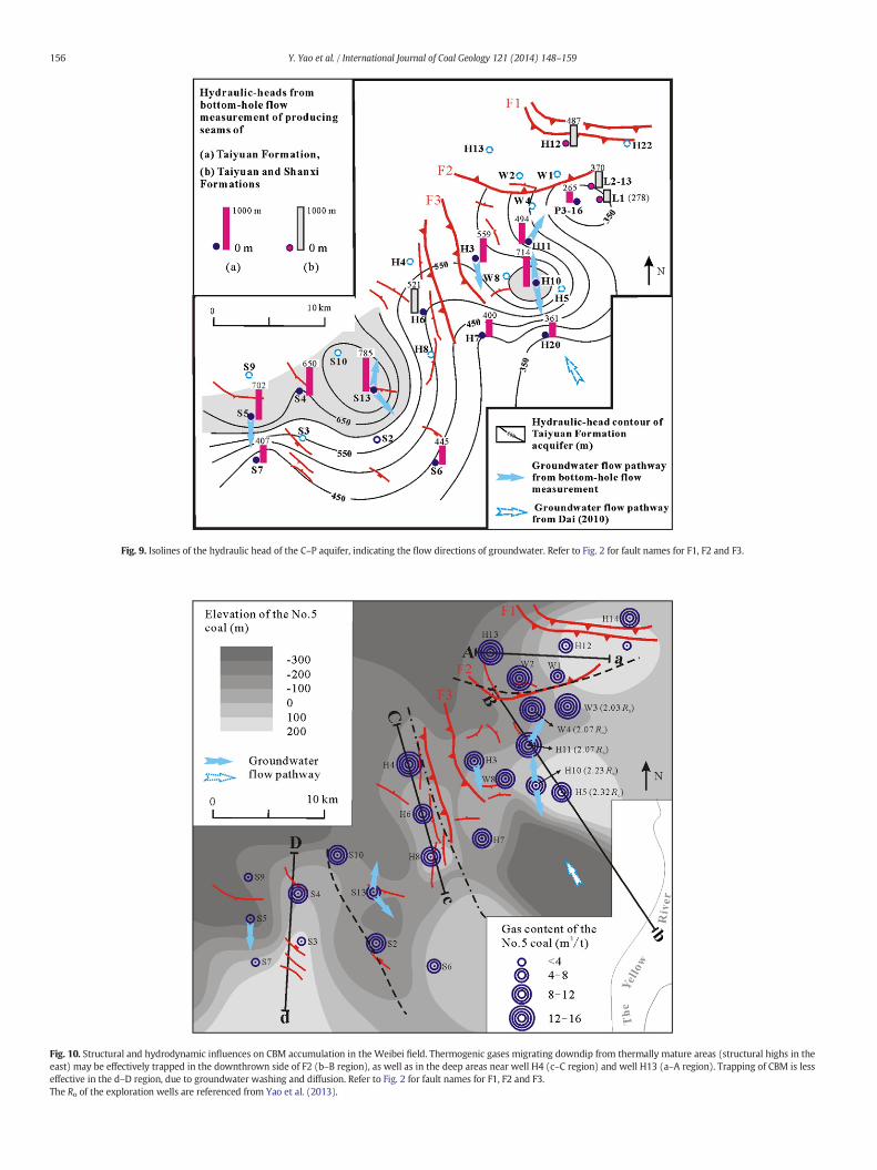
Fig. 9. Isolines of the hydraulic head of the C–P aquifer, indicating the flow directions of groundwater. Refer to Fig. 2 for fault names for F1, F2 and F3.
Fig. 10. Structural and hydrodynamic influences on CBM accumulation in the Weibei field. Thermogenic gases migrating downdip from thermally mature areas (structural highs in theeast) may be effectively trapped in the downthrown side of F2 (b–B region), as well as in the deep areas near well H4 (c–C region) and well H13 (a–A region). Trapping of CBM is lesseffective in the d–D region, due to groundwater washing and diffusion. Refer to Fig. 2 for fault names for F1, F2 and F3.The Ro of the exploration wells are referenced from Yao et al. (2013).
156 Y. Yao et al. / International Journal of Coal Geology 121 (2014) 148–159

Fig. 11. Northeast–southwest structural section showing the strata contact on both sides of the F2 fault. See Fig. 2 for location of cross section.
157Y. Yao et al. / International Journal of Coal Geology 121 (2014) 148–159
In contrast, the groundwater flow mechanism is completely differ-ent in the Heyang area, where the groundwater flows from north tosouth, and along the dip of the coal seam from deep (low elevation) toshallow (high elevation) (Fig. 10). In this situation, regardless of otherfactors, gas shouldmigrate from a deep areawith high hydrostatic pres-sure to a shallow area with low hydrostatic pressure. According to Yaoet al. (2009), coal reservoirs are commonly in a tensile stress field inthe Heyang area, which induces an open cleat system and a high-permeability coal reservoir. Moreover, there aremanyNW-striking nor-mal faults from south of S2 to north of S4, which provides migrationpathways for gas leakage through these normal faults. This explainsthe low gas content (2–8 m3/t) in the Heyang area.
4.5. Compartmentalization of gas accumulation
It is generally accepted that gas accumulation is a synergistic inter-play between the controls of coal geology, sedimentology, structural
Fig. 12. Northwest–southeast structural section showing the strata contac
geology and hydrogeology (Kaiser et al., 1994; Scott, 2002). In theWeibei field, gas accumulation is mainly affected by structural and hy-drodynamic factors. As shown in Fig. 10, the gas domains in the studyarea are geologically compartmentalized into regions ‘a–A’, ‘b–B’, ‘c–C’,and ‘d–D’.
Region ‘a–A’ is the area between faults F1 and F2, where the gas con-tent increases from east to west with increasing depth. Although someCBMproductionwells were completed in the eastern part of this region,gas production is low due to the low gas content. Since we did notcollect groundwater samples from this region, the geological andhydro-logic controls on gas accumulation are still unclear.
Region ‘b–B’ is the area between the southeast of fault F2 and east offault F3. The F2 fault is important for gas accumulation in this region. Gascontent is found to be distinctly high near the downthrown side, but lowat the upthrown side of fault F2. Fig. 11 is a northeast–southwest struc-tural section which just cuts across the F2 fault. This section is explainedfrom a 2D seismic section, and as well as the logs of two adjacent
t on both sides of the F2 fault. See Fig. 2 for location of cross section.

Fig. 13. Hydrostratigraphic cross section. Refer to Fig. 10 for the location of the cross section. From outcrops at the east rim of the study area, ground water recharged and repressuredaquifer coal seams. The F2 fault forms a barrier to the northwestward flow of groundwater, causing high hydrostatic pressure and high gas content at the downthrown side of F2.
158 Y. Yao et al. / International Journal of Coal Geology 121 (2014) 148–159
explorationwells ofW1 andW4. TheW1 drilled from the upthrown sideof F2 has a lowgas content of 7.42 m3/t, whereas theW2drilled from thedownthrown side of F2 has a gas content as high as 15.46 m3/t. Similarly,another northwest–southeast section also confirmed that the gas con-tent is high at the downthrown side of thrust faults (Fig. 12). As shownin Fig. 12, wells W2 and W4 are both drilled from the downthrownside of thrust faults, and they have a high gas content of 15.46 m3/tand 16.15 m3/t, respectively. The reason is that the F2 is compressiveand favorable for a gas trap. Meanwhile, the coal seams are overlaidwith thick shales, which is also favorable for gas accumulation (Figs. 11and 12).
A detailed geological and hydrologic profile ‘b–B’ (Fig. 13) indicatesthe geological and hydrologic control on gas accumulation in this re-gion. The flow of groundwater in the C–P aquifer is driven westward/northwestward by topography. According to Dai (2010), groundwaterrecharge of the Carboniferous–Permian aquifer occurs at high eleva-tions at the subcrop and outcrops along the Yellow River Valley. Fromsoutheast to northwest, the hydrogeology is approximately compart-mentalized into recharge, runoff and stagnant zones by the intensityof groundwater activities (Fig. 13). An inferred overpressured artesianregion is located east of fault F2, and the fault forms a barrier to west-ward water flow. As shown in the profile, the gas content of well H5,which is located in the runoff zone, is relatively low. However, ground-water trapped methane under hydrostatic pressure in the stagnantzones, and thus both the gas content and the methane concentrationof wells W4 and H11 are high (Fig. 13).
Region ‘c–C’ is the area southwest of fault F3, and the gas contentcommonly increases from southeast to northwest with increasingdepth and decreasing elevation. The groundwater flow pathway isfrom the south/southwest to north/northeast, and it appears to beblocked by fault F3 (Fig. 9). The migration of thermogenic solutiongases contributes to the methane gas supply in the coal seam, and thegroundwater in the coal seam contributes to the hydrostatic pressurein the reservoir that keeps methane gas adsorbed to the surface of thecoal. This mechanism may explain the very high gas content in thenorthwestern part of region ‘c–C’. The combined effects of pressure in-crease and the generation and/or migration and subsequent trappingof thermogenic solution gas resulted in the accumulation of gas nearwell H4.
Region ‘d–D’ is in theHeyang area,where gas contents increase fromsouth to north with increasing depth and decreasing elevation. Thegroundwater flows from north to south. According to Yao et al.(2013), the reservoir pressure in well S3 is very low, and gas samplesfromwells S7 and S3 have a high content of nitrogen that is transportedfrom the source of atmosphere by faults or fractures. These results indi-cate that gas accumulation has been destroyed. The CBM has desorbedfrom the coals and has been swept out to the atmosphere. As discussed,the influences by the flow of groundwater and structural characteristicsresult in a poor hydrodynamic mechanism for gas trapping. Therefore,in the southern portion of this region, where there is no mechanismfor entrapment, gas contents are low due to groundwater washingand diffusion.
5. Conclusions
In theWeibei field, the principal target seams for CBM developmentinclude Nos. 5 and 11 coals in the Taiyuan Formation, and No. 3 coal inthe Shanxi Formation. Structural and hydrodynamic mechanisms aretwo key controls on gas accumulation, based on which the study areaare divided into four gas domains. In the northern Hancheng area, thenorthwest flow of groundwater resulted in a higher gas content in thewest (N12 m3/t) than in the east (8–12 m3/t), even though the coalshave high thermal maturity in the east. The area with the highest gascontent (N15 m3/t) and production (1000–5000 m3/day) is near thedownthrown side of the Xuefeng–Nan Fault, where meteoric watermoving through higher rank coals in the east transports gas in solutionand is trapped at the permeability barrier of the fault. The area with thelowest gas content (b4 m3/t) is in the southwestern Heyang area,where there is no mechanism for entrapment and the gas has beenflushed out of the coals by the reduction of reservoir pressure and activegroundwater flow from the east.
The intensity of hydrodynamic activity and the groundwater flowpathway are important for gas accumulation. Flow pathways orientedalong dip and from high to low regions, are more effective in trappingmigrating thermogenic gases than those from low to high regions.Higher gas contents and production may be expected in areas adjacentto permeability barriers, e.g. the northwest side of the ‘b–B’ region.

159Y. Yao et al. / International Journal of Coal Geology 121 (2014) 148–159
Acknowledgments
We would like to thank China National Petroleum Corporation forproviding the exploration well data. This research was funded by Na-tional Natural Science Foundation of China (41102099), NationalMajor Research Program for Science and Technology of China(2011ZX05062-006; 2011ZX05034-001), Program for New CenturyExcellent Talents in University (NCET-11-0721), A Foundation for theAuthor of National Excellent Doctoral Dissertation of PR China(201253), and Fundamental Research Funds for the Central Universities(2652013026). The authors also thank Dr. Karacan for his constructivesuggestions in revising the manuscript.
References
Ayers Jr., W.B., 2002. Coalbed gas systems, resources, and production and a review ofcontrasting cases from the San Juan and Powder River Basins. AAPG Bull. 86,1853–1890.
Ayers Jr., W.B., Tisdale, R.M., Litzinger, L.A., Steidle, P.F., 1993. Coalbed methane potentialof Carboniferous strata in Great Britain. The 1993 International Coalbed MethaneSymposium Proceedings, The University of Alabama, Tuscaloosa, May 17–21,Birmingham, Alabama. vol. I, vol. I, pp. 1–14.
Bachu, S., Michael, K., 2003. Possible controls of hydrogeological and stress regimes on theproducibility of coalbed methane in upper Cretaceous–Tertiary strata of the AlbertBasin, Canada. AAPG Bull. 87 (11), 1729–1754.
Cai, Y., Liu, D., Yao, Y., Li, J., Qiu, Y., 2011. Geological controls on production of coalbedmethane of No. 3 coal seam in Southern Qinshui Basin, North China. Int. J. CoalGeol. 88, 101–112.
Dai, G., 2010. The effect of geology structure on hydrogeology characteristics of Hanchengmining area. J. Arid Land Res. Environ. 24 (7), 62–67 (in Chinese).
Flores, R.M., Rice, C.A., Stricker, G.D., Warden, A., Eillis, M.S., 2008. Methanogenicpathways of coal-bed gas in the Powder River Basin, United States: the geologicfactor. Int. J. Coal Geol. 76, 52–75.
Fu, X., Qin, Y., Yang, Y., Peng, J., Hancheng, X., 2004. Experimental study of the solubility ofmethane in coalbed water. Nat. Gas Geosci. 15 (4), 345–348.
Kaiser, W.R., Hamilton, D.S., Scott, A.R., Tyler, R., Finley, R.J., 1994. Geological and hydro-logical controls on the producibility of coalbed methane. Geol. Soc. Lond. 151,417–420.
Karacan, C.Ö., Goodman, G.V.R., 2012. Analyses of geological and hydrodynamic controlson methane emissions experienced in a Lower Kittanning coal mine. Int. J. CoalGeol. 98, 110–127.
Kinnon, E.C.P., Golding, S.D., Borehan, C.J., Baublys, K.A., Esterle, J.S., 2010. Stable isotopeand water quality analysis of coal seam methane production waters and gases fromthe Bowen Basin, Australia. Int. J. Coal Geol. 82, 219–231.
Lamarre, R.A., 2003. Hydrodynamic and stratigraphic controls for a large coalbedmethane accumulation in Ferron coals of east-central Utah. Int. J. Coal Geol. 56,97–110.
Pashin, J.C., 2007. Hydrodynamics of coalbed methane reservoirs in the Black WarriorBasin: key to understanding reservoir performance and environmental issues. Appl.Geochem. 22, 2257–2272.
Pashin, J.C., Groshong Jr., R.H., 1998. Structural control of coalbed methane production inAlabama. Int. J. Coal Geol. 38, 89–113.
Qin, S., Tang, X., Song, Y., Wang, H., 2006. Distribution and fractionation mechanism ofstable carbon isotope of coalbed methane. Sci. China Ser. D Earth Sci. 49 (12),1252–1258.
Rice, C.A., Flores, R.M., Stricker, G.D., Ellis, M.S., 2008. Chemical and stable isotopicevidence for water/rock interaction and biogenic origin of coalbed methane, FortUnion Formation, Powder River Basin, Wyoming and Montana U.S.A. Int. J. CoalGeol. 76, 76–85.
Scott, A.R., 2002. Hydrogeologic factors affecting gas content distribution in coal beds. Int.J. Coal Geol. 50, 363–387.
Scott, A.R., Kaiser, W.R., Ayers Jr., W.B., 1994. Thermogenic and secondary biogenic gases,San Juan Basin, Colorado and New Mexico — implications for coalbed methaneproducibility. AAPG Bull. 78, 1186–1209.
Song, Y., Liu, H., Hong, F., Qin, S., Liu, S., Li, G., Zhao, M., 2012. Syncline reservoir pooling asa general model for coalbed methane (CBM) accumulations: mechanisms and casestudies. J. Pet. Sci. Eng. 88–89, 5–12.
Van Voast, W.A., 2003. Geochemical signature of formation waters associated withcoalbed methane. AAPG Bull. 87 (4), 667–676.
Xie, C., Pang, X., 1994. Application of environmental isotope techniques on the researchesof the groundwater properties in the Weibei coalfield. Coal Sci. Technol. 22 (2),47–50.
Xu, H., Tang, D., Liu, D., Tang, S., Yang, F., Chen, X., He,W., Deng, C., 2012. Study on coalbedmethane accumulation characteristics and favorable areas in the Binchang area,southwestern Ordos Basin, China. Int. J. Coal Geol. 95, 1–11.
Yao, Y., Liu, D., Tang, D., Tang, S., Che, Y., Huang, W., 2009. Preliminary evaluation of thecoalbed methane production potential and its geological controls in the WeibeiCoalfield, Southeastern Ordos Basin, China. Int. J. Coal Geol. 78, 1–15.
Yao, Y., Liu, D., Qiu, Y., 2013. Variable gas content, saturation and accumulation character-istics of Weibei coalbed methane pilot-production field in Southeast Ordos Basin,China. AAPG Bull. 97 (8), 1371–1393.