international tribunal for the law of the … · the people’s republic of bangladesh, ... mr...
TRANSCRIPT

INTERNATIONAL TRIBUNAL FOR THE LAW OF THE SEA YEAR 2012
14 March 2012
No. 16 List of cases:
DISPUTE CONCERNING DELIMITATION OF THE MARITIME BOUNDARY
BETWEEN BANGLADESH AND MYANMAR IN THE BAY OF BENGAL
(BANGLADESH/MYANMAR)
JUDGMENT

TABLE OF CONTENTS
I. Procedural history 1-30 II. Submissions of the Parties 31-32 III. Factual background 33-39 Regional geography 33-35
Brief history of the negotiations between the Parties 36-39
IV. Subject-matter of the dispute 40 V. Jurisdiction 41-50 VI. Applicable law 51-55 VII. Territorial sea 56-176 The 1974 and 2008 Agreed Minutes 57-99
Use of the term “agreement” in article 15 of the
Convention 70-71
Terms of the “Agreed Minutes” and circumstances
of their adoption 72-79
Full powers 80-85
Registration 86-87
Tacit or de facto agreement 100-118
Estoppel 119-125
Delimitation of the territorial sea 126-176
Historic title and other special circumstances 130-152
Delimitation line 153-169

3
Right of passage of ships of Myanmar through the
territorial sea of Bangladesh around St. Martin’s
Island 170-176
VIII. Exclusive economic zone and continental shelf within 200 nautical miles 177-340
Single delimitation line 178-181
Applicable law 182-184
Relevant coasts 185-205
Bangladesh’s relevant coast 200-202
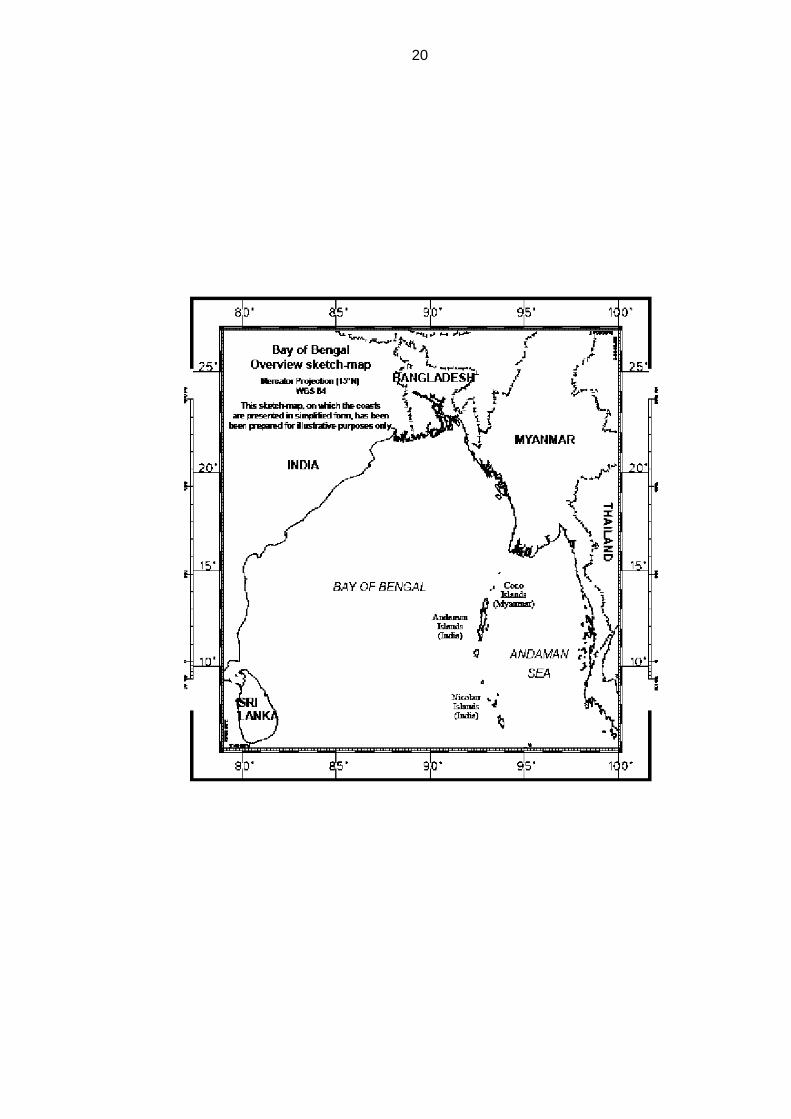
Myanmar’s relevant coast 203-205
Method of delimitation 206-240
Establishment of the provisional equidistance line 241-274
Selection of base points 241-266
Construction of the provisional equidistance
line 267-274
Relevant circumstances 275-322
Concavity and cut-off effect 279-297
St. Martin’s Island 298-319
Bengal depositional system 320-322
Adjustment of the provisional equidistance line 323-336
Delimitation line 337-340
IX. Continental shelf beyond 200 nautical miles 341-476 Jurisdiction to delimit the continental shelf in its entirety 341-394
Exercise of jurisdiction 364-394

4
Entitlement 395-449
Entitlement and delimitation 397-423
Meaning of natural prolongation 424-438
Determination of entitlements 439-449
Delimitation of the continental shelf beyond 200 nautical
miles 450-462
Delimitation line 461-462
“Grey area” 463-476
X. Disproportionality test 477-499
XI. Description of the delimitation line 500-505
XII. Operative clauses 506
5
Present: President JESUS; Vice-President TÜRK; Judges MAROTTA RANGEL, YANKOV, NELSON, CHANDRASEKHARA RAO, AKL, WOLFRUM, TREVES, NDIAYE, COT, LUCKY, PAWLAK, YANAI, KATEKA, HOFFMANN, GAO, BOUGUETAIA, GOLITSYN, PAIK; Judges ad hoc MENSAH, OXMAN; Registrar GAUTIER.
In the Dispute concerning Delimitation of the Maritime Boundary between Bangladesh and Myanmar in the Bay of Bengal
between
The People’s Republic of Bangladesh, represented by
H.E. Ms Dipu Moni, Minister of Foreign Affairs,
as Agent;
Mr Md. Khurshed Alam, Rear Admiral (Ret’d), Additional Secretary, Ministry of Foreign Affairs,
as Deputy Agent; and
H.E. Mr Mohamed Mijraul Quayes, Foreign Secretary, Ministry of Foreign Affairs,
H.E. Mr Mosud Mannan, Ambassador of the People’s Republic of Bangladesh to the Federal Republic of Germany,
Mr Payam Akhavan, Professor of International Law, McGill University, Canada, Member of the Bar of New York, United States of America,
Mr Alan Boyle, Professor of International Law, University of Edinburgh, Member of the Bar of England and Wales, United Kingdom,
Mr James Crawford, S.C., F.B.A., Whewell Professor of International Law, University of Cambridge, United Kingdom, Member of the Bar of England and Wales, United Kingdom, Member of the Institut de droit international,
Mr Lawrence H. Martin, Foley Hoag LLP, Member of the Bars of the United States Supreme Court, the Commonwealth of Massachusetts and the District of Columbia, United States of America,
Mr Lindsay Parson, Director, Maritime Zone Solutions Ltd., United Kingdom,
Mr Paul S. Reichler, Foley Hoag LLP, Member of the Bars of the United States Supreme Court and the District of Columbia, United States of America,
6
Mr Philippe Sands, Q.C., Professor of International Law, University College London, Member of the Bar of England and Wales, United Kingdom, as Counsel and Advocates;
Mr Md. Gomal Sarwar, Director General, Ministry of Foreign Affairs, Mr Jamal Uddin Ahmed, Assistant Secretary, Ministry of Foreign
Affairs, Ms Shahanara Monica, Assistant Secretary, Ministry of Foreign Affairs, Mr M. R. I. Abedin, Lt. Cdr., System Analyst, Ministry of Foreign Affairs, Mr Robin Cleverly, Law of the Sea Consultant, United Kingdom
Hydrographic Office, United Kingdom, Mr Scott Edmonds, Cartographic Consultant, International Mapping,
United States of America, Mr Thomas Frogh, Senior Cartographer, International Mapping, United
States of America, Mr Robert W. Smith, Geographic Consultant, United States of America, as Advisers;
Mr Joseph R. Curray, Professor of Geology, Emeritus, Scripps
Institution of Oceanography, University of California, United States of America,
Mr Hermann Kudrass, Former Director and Professor (Retired), German Federal Institute for Geosciences and Natural Resources (BGR), Germany,
as Independent Experts;
Ms Solène Guggisberg, Ph.D. Candidate, International Max Planck
Research School for Maritime Affairs, Germany, Mr Vivek Krishnamurthy, Foley Hoag LLP, Member of the Bars of New
York and the District of Columbia, United States of America, Mr Bjarni Már Magnússon, Ph.D. Candidate, University of Edinburgh,
United Kingdom, Mr Yuri Parkhomenko, Foley Hoag LLP, United States of America, Mr Remi Reichhold, Research Assistant, Matrix Chambers, London,
United Kingdom, as Junior Counsel,

7
and
The Republic of the Union of Myanmar,
represented by
H.E. Mr Tun Shin, Attorney General,
as Agent;
Ms Hla Myo Nwe, Deputy Director General, Consular and Legal Affairs Department, Ministry of Foreign Affairs, Mr Kyaw San, Deputy Director General, Attorney General’s Office of the Republic of the Union of Myanmar,
as Deputy Agents; and
Mr Mathias Forteau, Professor, University of Paris Ouest, Nanterre La Défense, France,
Mr Coalter Lathrop, Attorney-Adviser, Sovereign Geographic, Member of the North Carolina Bar, United States of America,
Mr Daniel Müller, Consultant in Public International Law, Researcher, Centre de droit international de Nanterre (CEDIN), University of Paris Ouest, Nanterre La Défense, France,
Mr Alain Pellet, Professor, University of Paris Ouest, Nanterre La Défense, France, Member and former Chairman of the International Law Commission, Associate Member of the Institut de droit international,
Mr Benjamin Samson, Researcher, Centre de droit international de Nanterre (CEDIN), University of Paris Ouest, Nanterre La Défense, France,
Mr Eran Sthoeger, LL.M., New York University School of Law, United States of America,
Sir Michael Wood, K.C.M.G., Member of the English Bar, United Kingdom, Member of the International Law Commission,
as Counsel and Advocates; H.E. Mr U Tin Win, Ambassador Extraordinary and Plenipotentiary of
the Republic of the Union of Myanmar to the Federal Republic of Germany, Mr Min Thein Tint, Captain, Commanding Officer, Myanmar Naval
Hydrographic Center, Mr Thura Oo, Pro-Rector of the Meiktila University, Myanmar, Mr Maung Maung Myint, Counselor, Embassy of the Republic of the
Union of Myanmar to the Federal Republic of Germany, Mr Kyaw Htin Lin, First Secretary, Embassy of the Republic of the
Union of Myanmar to the Federal Republic of Germany, Ms Khin Oo Hlaing, First Secretary, Embassy of the Republic of the
Union of Myanmar to the Kingdom of Belgium,

8
Mr Mang Hau Thang, Assistant Director, International Law and Treaties Division, Consular and Legal Affairs Department, Ministry of Foreign Affairs,
Ms Tin Myo Nwe, Attaché, International Law and Treaties Division, Consular and Legal Affairs Department, Ministry of Foreign Affairs,
Ms Héloïse Bajer-Pellet, Lawyer, Member of the Paris Bar, France, Mr Octavian Buzatu, Hydrographer, Romania, Ms Tessa Barsac, Master, University of Paris Ouest, Nanterre La
Défense, France, Mr David Swanson, Cartography Consultant, United States of America, Mr Bjørn Kunoy, Doctoral Candidate, Université Paris Ouest, Nanterre-
La Défense, France, Mr David P. Riesenberg, LL.M., Duke University School of Law, United
States of America,
as Advisers,
9
THE TRIBUNAL,
composed as above,
after deliberation,
delivers the following Judgment:
I. Procedural history 1. The Minister of Foreign Affairs of the People’s Republic of Bangladesh,
by a letter dated 13 December 2009, notified the President of the Tribunal
that, on 8 October 2009, the Government of Bangladesh had instituted arbitral
proceedings against the Union of Myanmar (now the Republic of the Union of
Myanmar, see paragraph 18) pursuant to Annex VII of the United Nations
Convention on the Law of the Sea (hereinafter “the Convention”) “to secure
the full and satisfactory delimitation of Bangladesh’s maritime boundaries with
[…] Myanmar in the territorial sea, the exclusive economic zone and the
continental shelf in accordance with international law”. This letter was filed
with the Registry of the Tribunal on 14 December 2009.
2. By the same letter, the Minister of Foreign Affairs of Bangladesh
notified the President of the Tribunal of declarations made under article 287 of
the Convention by Myanmar and Bangladesh on 4 November 2009 and
12 December 2009, respectively, concerning the settlement of the dispute
between the two Parties relating to the delimitation of their maritime boundary
in the Bay of Bengal. The letter stated:
[g]iven Bangladesh’s and Myanmar’s mutual consent to the jurisdiction of ITLOS, and in accordance with the provisions of UNCLOS Article 287(4), Bangladesh considers that your distinguished Tribunal is now the only forum for the resolution of the parties’ dispute.
10
On that basis, the Minister of Foreign Affairs of Bangladesh invited the
Tribunal “to exercise jurisdiction over the maritime boundary dispute between
Bangladesh and Myanmar”.
3. The declaration of Myanmar stated:
In accordance with Article 287, paragraph 1, of the 1982 United Nations Convention on the Law of the Sea (UNCLOS), the Government of the Union of Myanmar hereby declares that it accepts the jurisdiction of the International Tribunal for the Law of the Sea for the settlement of dispute between the Union of Myanmar and the People’s Republic of Bangladesh relating to the delimitation of maritime boundary between the two countries in the Bay of Bengal.
4. The declaration of Bangladesh stated:
Pursuant to Article 287, paragraph 1, of the 1982 United Nations Convention on the Law of the Sea, the Government of the People’s Republic of Bangladesh declares that it accepts the jurisdiction of the International Tribunal for the Law of the Sea for the settlement of the dispute between the People’s Republic of Bangladesh and the Union of Myanmar relating to the delimitation of their maritime boundary in the Bay of Bengal.
5. In view of the above-mentioned declarations, and the letter of the
Minister of Foreign Affairs of Bangladesh dated 13 December 2009 referred to
in paragraphs 1 and 2, the case was entered in the List of cases as Case
No. 16 on 14 December 2009. On that same date, the Registrar, pursuant to
article 24, paragraph 2, of the Statute of the Tribunal (hereinafter “the
Statute”), transmitted a certified copy of the notification made by Bangladesh
to the Government of Myanmar.
6. By a letter dated 17 December 2009, the Registrar notified the
Secretary-General of the United Nations of the institution of proceedings. By a
note verbale dated 22 December 2009, the Registrar also notified the States
Parties to the Convention, in accordance with article 24, paragraph 3, of the
Statute.
11
7. By a letter dated 22 December 2009, the Minister of Foreign Affairs of
Bangladesh, acting as Agent in the case, informed the President of the
Tribunal of the designation of Mr Md. Khurshed Alam, Additional Secretary,
Ministry of Foreign Affairs, as the Deputy Agent of Bangladesh. By a note
verbale dated 23 December 2009, the Ministry of Foreign Affairs of Myanmar
informed the Tribunal of the appointment of Mr Tun Shin, Attorney General, as
Agent, and Ms Hla Myo Nwe, Deputy Director General, Ministry of Foreign
Affairs, and Mr Nyan Naing Win, Deputy Director, Attorney General’s Office,
as Deputy Agents. Subsequently, by a letter dated 24 May 2011, the Agent of
Myanmar informed the Tribunal that Myanmar had appointed Mr Kyaw San,
Deputy Director General, Attorney General’s Office, as Deputy Agent in place
of Mr Nyan Naing Win.
8. By a letter dated 14 January 2010, the Ambassador of Myanmar to
Germany transmitted a letter from the Minister of Foreign Affairs of Myanmar
of the same date, in which Myanmar informed the Registrar that it had
“transmitted the Declaration to withdraw its previous declaration accepting the
jurisdiction of ITLOS made on 4 November 2009 by the Minister of Foreign
Affairs of Myanmar, to the Secretary-General of the United Nations on
14th
January 2010”. On the same date, the Registrar transmitted a copy of the
aforementioned letters to Bangladesh.
9. In a letter dated 18 January 2010 addressed to the Registrar, the
Deputy Agent of Bangladesh stated that Myanmar’s withdrawal of its
declaration of acceptance of the Tribunal’s jurisdiction did “not in any way
affect proceedings regarding the dispute that have already commenced
before ITLOS, or the jurisdiction of ITLOS with regard to such proceedings”. In
this regard, Bangladesh referred to article 287, paragraphs 6 and 7, of the
Convention.
10. Consultations were held by the President with the representatives of
the Parties on 25 and 26 January 2010 to ascertain their views regarding
questions of procedure in respect of the case. In this context, it was noted
that, for the reasons indicated in paragraph 5, the case had been entered in

12
the List of cases as Case No. 16. The representatives of the Parties
concurred that 14 December 2009 was to be considered the date of institution
of proceedings before the Tribunal.
11. In accordance with articles 59 and 61 of the Rules of the Tribunal
(hereinafter “the Rules”), the President, having ascertained the views of the
Parties, by Order dated 28 January 2010, fixed the following time-limits for the
filing of the pleadings in the case: 1 July 2010 for the Memorial of Bangladesh
and 1 December 2010 for the Counter-Memorial of Myanmar. The Registrar
forthwith transmitted a copy of the Order to the Parties. The Memorial and the
Counter-Memorial were duly filed within the time-limits so fixed.
12. Pursuant to articles 59 and 61 of the Rules, the views of the Parties
having been ascertained by the President, the Tribunal, by Order dated
17 March 2010, authorized the submission of a Reply by Bangladesh and a
Rejoinder by Myanmar and fixed 15 March 2011 and 1 July 2011,
respectively, as the time-limits for the filing of those pleadings. The Registrar
forthwith transmitted a copy of the Order to the Parties. The Reply and the
Rejoinder were duly filed within the time-limits so fixed.
13. Since the Tribunal does not include upon the bench a member of the
nationality of the Parties, each of the Parties availed itself of its right under
article 17 of the Statute to choose a judge ad hoc. Bangladesh, by its letter
dated 13 December 2009 referred to in paragraph 1, chose Mr Vaughan Lowe
and Myanmar, by a letter dated 12 August 2010, chose Mr Bernard H. Oxman
to sit as judges ad hoc in the case. No objection to the choice of Mr Lowe as
judge ad hoc was raised by Myanmar, and no objection to the choice of
Mr Oxman as judge ad hoc was raised by Bangladesh, and no objection
appeared to the Tribunal itself. Consequently, the Parties were informed by
letters from the Registrar dated 12 May 2010 and 20 September 2010,
respectively, that Mr Lowe and Mr Oxman would be admitted to participate in
the proceedings as judges ad hoc, after having made the solemn declaration
required under article 9 of the Rules.
13
14. By a letter dated 1 September 2010, Mr Lowe informed the President
that he was not in a position to act as a judge ad hoc in the case.
15. By a letter dated 13 September 2010, pursuant to article 19,
paragraph 4, of the Rules, the Deputy Agent of Bangladesh informed the
Registrar of Bangladesh’s choice of Mr Thomas Mensah as judge ad hoc in
the case, to replace Mr Lowe. Since no objection to the choice of Mr Mensah
as judge ad hoc was raised by Myanmar, and no objection appeared to the
Tribunal itself, the Registrar informed the Parties by a letter dated 26 October
2010 that Mr Mensah would be admitted to participate in the proceedings as
judge ad hoc, after having made the solemn declaration required under
article 9 of the Rules.
16. On 16 February 2011, the President held consultations with the
representatives of the Parties regarding the organization of the hearing, in
accordance with article 45 of the Rules.
17. By a letter dated 22 July 2011 addressed to the Registrar, the Consul-
General of Japan in Hamburg requested that copies of the written pleadings
be made available to Japan. The views of the Parties having been
ascertained by the President, the requested copies were made available,
pursuant to article 67, paragraph 1, of the Rules, by a letter dated 22 August
2011 from the Registrar to the Consul-General of Japan.
18. By a note verbale dated 15 August 2011, the Embassy of Myanmar in
Berlin informed the Registry that the name of the country had been changed
from the “Union of Myanmar” to the “Republic of the Union of Myanmar” as of
March 2011.
19. The President, having ascertained the views of the Parties, by an
Order dated 19 August 2011, fixed 8 September 2011 as the date for the
opening of the oral proceedings.
14
20. At a public sitting held on 5 September 2011, Mr Thomas Mensah,
Judge ad hoc chosen by Bangladesh, and Mr Bernard H. Oxman, Judge ad
hoc chosen by Myanmar, made the solemn declaration required under
article 9 of the Rules.
21. In accordance with article 68 of the Rules, the Tribunal held initial
deliberations on 5, 6 and 7 September 2011 to enable judges to exchange
views concerning the written pleadings and the conduct of the case. On
7 September 2011, it decided, pursuant to article 76, paragraph 1, of the
Rules, to communicate to the Parties two questions which it wished them
specially to address. These questions read as follows:
1. Without prejudice to the question whether the Tribunal has jurisdiction to delimit the continental shelf beyond 200 nautical miles, would the Parties expand on their views with respect to the delimitation of the continental shelf beyond 200 nautical miles?
2. Given the history of discussions between them on the issue, would the Parties clarify their position regarding the right of passage of ships of Myanmar through the territorial sea of Bangladesh around St. Martin’s Island?
22. On 7 September 2011, the President held consultations with the
representatives of the Parties to ascertain their views regarding the hearing
and transmitted to them the questions referred to in paragraph 21.
23. Prior to the opening of the oral proceedings, on 7 September 2011, the
Agent of Bangladesh communicated information required under paragraph 14
of the Guidelines concerning the Preparation and Presentation of Cases
before the Tribunal.
24. The Agent of Myanmar communicated information required under
paragraph 14 of the Guidelines concerning the Preparation and Presentation
of Cases before the Tribunal on 9 September 2011 and additional information
on 14 September 2011.
25. From 8 to 24 September 2011, the Tribunal held 15 public sittings. At
these sittings, the Tribunal was addressed by the following:

15
For Bangladesh: H.E. Ms Dipu Moni, Mr Md. Khurshed Alam, as Agent and Deputy Agent; H.E. Mr Mohamed Mijraul Quayes, Mr Payam Akhavan, Mr Alan Boyle, Mr James Crawford, Mr Lawrence H. Martin, Mr Lindsay Parson, Mr Paul S. Reichler, Mr Philippe Sands, as Counsel and Advocates. For Myanmar:
H.E. Mr Tun Shin, as Agent; Mr Mathias Forteau,
Mr Coalter Lathrop, Mr Daniel Müller,
Mr Alain Pellet, Mr Benjamin Samson, Mr Eran Sthoeger, Sir Michael Wood,
as Counsel and Advocates.
26. In the course of the oral proceedings, the Parties displayed a number
of slides, including maps, charts and excerpts from documents, and
animations on video monitors. Electronic copies of these documents were
filed with the Registry by the Parties.
27. The hearing was broadcast over the internet as a webcast.
28. Pursuant to article 67, paragraph 2, of the Rules, copies of the
pleadings and the documents annexed thereto were made accessible to the
public on the opening of the oral proceedings.
29. In accordance with article 86 of the Rules, verbatim records of each
hearing were prepared by the Registrar in the official languages of the
Tribunal used during the hearing. Copies of the transcripts of such records

16
were circulated to the judges sitting in the case and to the Parties. The
transcripts were made available to the public in electronic form.
30. President Jesus, whose term of office as President expired on
30 September 2011, continued to preside over the Tribunal in the present
case until completion, pursuant to article 16, paragraph 2, of the Rules. In
accordance with article 17 of the Rules, Judges Yankov and Treves, whose
term of office expired on 30 September 2011, having participated in the
meeting mentioned in article 68 of the Rules, continued to sit in the case until
its completion. Judge Caminos, whose term of office also expired on
30 September 2011, was prevented by illness from participating in the
proceedings.
II. Submissions of the Parties
31. In their written pleadings, the Parties presented the following
submissions:
In its Memorial and its Reply, Bangladesh requested the Tribunal to adjudge
and declare that:
1. The maritime boundary between Bangladesh and Myanmar in the territorial sea shall be that line first agreed between them in 1974 and reaffirmed in 2008. The coordinates for each of the seven points comprising the delimitation are:
No. Latitude Longitude
1. 20° 42’ 15.8” N 92° 22’ 07.2” E 2. 20° 40’ 00.5” N 92° 21’ 5.2” E 3. 20° 38’ 53.5” N 92° 22’ 39.2” E 4. 20° 37’ 23.5” N 92° 23’ 57.2” E 5. 20° 35’ 53.5” N 92° 25’ 04.2” E 6. 20° 33’ 40.5” N 92° 25’ 49.2” E 7. 20° 22’ 56.6” N 92° 24’ 24.2” E
2. From Point 7, the maritime boundary between Bangladesh and Myanmar follows a line with a geodesic azimuth of 215° to the point located at 17° 25’ 50.7” N - 90° 15’ 49.0” E; and
17
3. From that point, the maritime boundary between Bangladesh and Myanmar follows the contours of the 200 M limit drawn from Myanmar’s normal baselines to the point located at 15° 42’ 54.1” N - 90° 13’ 50.1” E.
(All points referenced are referred to WGS 84.)
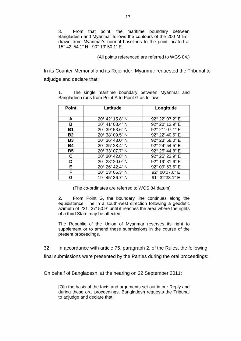
In its Counter-Memorial and its Rejoinder, Myanmar requested the Tribunal to
adjudge and declare that:
1. The single maritime boundary between Myanmar and Bangladesh runs from Point A to Point G as follows:
Point Latitude
Longitude
A 20° 42’ 15.8” N 92° 22’ 07.2” E B 20° 41’ 03.4” N 92° 20’ 12.9” E
B1 20° 39’ 53.6” N 92° 21’ 07.1” E B2 20° 38’ 09.5” N 92° 22’ 40.6” E B3 20° 36’ 43.0” N 92° 23’ 58.0” E B4 20° 35’ 28.4” N 92° 24’ 54.5” E B5 20° 33’ 07.7” N 92° 25’ 44.8” E C 20° 30’ 42.8” N 92° 25’ 23.9” E D 20° 28’ 20.0” N 92° 19’ 31.6” E E 20° 26’ 42.4” N 92° 09’ 53.6” E F 20° 13’ 06.3” N 92° 00’07.6” E G 19° 45’ 36.7” N 91° 32’38.1” E
(The co-ordinates are referred to WGS 84 datum) 2. From Point G, the boundary line continues along the equidistance line in a south-west direction following a geodetic azimuth of 231° 37’ 50.9” until it reaches the area where the rights of a third State may be affected. The Republic of the Union of Myanmar reserves its right to supplement or to amend these submissions in the course of the present proceedings.
32. In accordance with article 75, paragraph 2, of the Rules, the following
final submissions were presented by the Parties during the oral proceedings:
On behalf of Bangladesh, at the hearing on 22 September 2011:
[O]n the basis of the facts and arguments set out in our Reply and during these oral proceedings, Bangladesh requests the Tribunal to adjudge and declare that:

18
(1) The maritime boundary between Bangladesh and Myanmar in the territorial sea shall be that line first agreed between them in 1974 and reaffirmed in 2008. The coordinates for each of the seven points comprising the delimitation are those set forth in our written Submissions in the Memorial and Reply; (2) From Point 7, the maritime boundary between Bangladesh and Myanmar follows a line with a geodesic azimuth of 215° to the point located at the coordinates set forth in paragraph 2 of the Submissions as set out in the Reply; and (3) From that point, the maritime boundary between Bangladesh and Myanmar follows the contours of the 200-M limit drawn from Myanmar’s normal baselines to the point located at the coordinates set forth in paragraph 3 of the Submissions as set out in the Reply.
On behalf of Myanmar, at the hearing on 24 September 2011:
Having regard to the facts and law set out in the Counter-Memorial and the Rejoinder, and at the oral hearing, the Republic of the Union of Myanmar requests the Tribunal to adjudge and declare that: 1. The single maritime boundary between Myanmar and Bangladesh runs from point A to point G, as set out in the Rejoinder. […] 2. From point G, the boundary line continues along the equidistance line in a south-west direction following a geodetic azimuth of 231° 37' 50.9” until it reaches the area where the rights of a third State may be affected.
III. Factual Background
Regional geography (see overview sketch-map on page 20)
33. The maritime area to be delimited in the present case lies in the
northeastern part of the Bay of Bengal. This Bay is situated in the
northeastern Indian Ocean, covering an area of approximately 2.2 million
square kilometres, and is bordered by Sri Lanka, India, Bangladesh and
Myanmar.

19
34. Bangladesh is situated to the north and northeast of the Bay of Bengal.
Its land territory borders India and Myanmar and covers an area of
approximately 147,000 square kilometres.
35. Myanmar is situated to the east of the Bay of Bengal. Its land territory
borders Bangladesh, India, China, Laos and Thailand and covers an area of
approximately 678,000 square kilometres.
20

21
Brief history of the negotiations between the Parties
36. Prior to the institution of these proceedings, negotiations on the
delimitation of the maritime boundary were held between Bangladesh and
Myanmar from 1974 to 2010. Eight rounds of talks took place between 1974
and 1986 and six rounds between 2008 and 2010.
37. During the second round of talks, held in Dhaka between 20 and
25 November 1974, the heads of the two delegations, on 23 November 1974,
signed the “Agreed Minutes between the Bangladesh Delegation and the
Burmese Delegation regarding the Delimitation of the Maritime Boundary
between the Two Countries” (hereinafter “the 1974 Agreed Minutes”; see
paragraph 57).
38. On the resumption of the talks in 2008, at the first round held in Dhaka
from 31 March to 1 April 2008, the heads of delegations on 1 April 2008,
signed the “Agreed Minutes of the meeting held between the Bangladesh
Delegation and the Myanmar Delegation regarding the delimitation of the
Maritime Boundaries between the two countries” (hereinafter “the 2008
Agreed Minutes”; see paragraph 58).
39. In the summary of discussions signed by the heads of the delegations
at the fifth round, held in Chittagong on 8 and 9 January 2010, it was noted
that Bangladesh had already initiated arbitration proceedings under Annex VII
to the Convention.
IV. Subject-matter of the dispute 40. The dispute concerns the delimitation of the maritime boundary
between Bangladesh and Myanmar in the Bay of Bengal with respect to the
territorial sea, the exclusive economic zone and the continental shelf.

22
V. Jurisdiction 41. Bangladesh observes that the Parties have expressly recognized the
jurisdiction of the Tribunal over the dispute, as reflected in their declarations
made under article 287. It states that “the subject-matter of the dispute is
exclusively concerned with the provisions of UNCLOS and thus falls entirely
within ITLOS jurisdiction as agreed by the parties”.
42. Bangladesh asserts that its “claim is based on the provisions of
UNCLOS as applied to the relevant facts, including but not limited to UNCLOS
Articles 15, 74, 76 and 83” and that “[t]hese provisions relate to the
delimitation of the territorial sea, exclusive economic zone and continental
shelf, including the outer continental shelf beyond 200” nautical miles
(hereinafter “nm”).
43. Bangladesh states that the Tribunal’s jurisdiction to delimit the maritime
boundary between Bangladesh and Myanmar in respect of all the maritime
areas in dispute, including the part of the continental shelf beyond 200 nm
from the baselines from which the breadth of the territorial sea is measured
(hereinafter “the continental shelf beyond 200 nm”) is recognized under the
Convention and concludes that the Tribunal’s jurisdiction in regard to the
dispute between Bangladesh and Myanmar is plainly established.
44. Myanmar notes that the two Parties in their declarations under
article 287, paragraph 1, of the Convention accepted the jurisdiction of the
Tribunal to settle the dispute relating to the delimitation of their maritime
boundary in the Bay of Bengal. It states that the dispute before this Tribunal
concerns the delimitation of the territorial sea, the exclusive economic zone
and the continental shelf of Myanmar and Bangladesh in the Bay of Bengal.
45. Myanmar does not dispute that, “as a matter of principle, the
delimitation of the continental shelf, including the shelf beyond 200 [nm], could
fall within the jurisdiction of the Tribunal”. However, it submits that “in the
present case, the Tribunal does not have jurisdiction with regard to the
continental shelf beyond 200 [nm]”. In this regard Myanmar contends that,

23
even if the Tribunal were to decide that it has jurisdiction to delimit the
continental shelf beyond 200 nm, it would not be appropriate for the Tribunal
to exercise that jurisdiction in the present case.
* * *
46. The Tribunal notes that Bangladesh and Myanmar are States Parties to
the Convention. Bangladesh ratified the Convention on 27 July 2001 and the
Convention entered into force for Bangladesh on 26 August 2001. Myanmar
ratified the Convention on 21 May 1996 and the Convention entered into force
for Myanmar on 20 June 1996.
47. The Tribunal observes that Myanmar and Bangladesh, by their
declarations under article 287, paragraph 1, of the Convention, quoted in
paragraphs 3 and 4, accepted the jurisdiction of the Tribunal for the
settlement of the dispute between them relating to the delimitation of their
maritime boundary in the Bay of Bengal and that these declarations were in
force at the time proceedings before the Tribunal were instituted on
14 December 2009.
48. Pursuant to article 288, paragraph 1, of the Convention and article 21
of the Statute, the jurisdiction of the Tribunal comprises all disputes and all
applications submitted to it in accordance with the Convention. In the view of
the Tribunal, the present dispute entails the interpretation and application of
the relevant provisions of the Convention, in particular articles 15, 74, 76 and
83 thereof.
49. The Tribunal further observes that the Parties agree that the Tribunal
has jurisdiction to adjudicate the dispute relating to the delimitation of the
territorial sea, the exclusive economic zone and the continental shelf within
200 nm from the baselines from which the breadth of the territorial sea is
measured (hereinafter “the continental shelf within 200 nm”).

24
50. Accordingly, the Tribunal concludes that it has jurisdiction to delimit the
maritime boundary between the Parties in the territorial sea, the exclusive
economic zone and the continental shelf within 200 nm. The Tribunal will deal
with the issue of its jurisdiction with respect to the delimitation of the
continental shelf beyond 200 nm in paragraphs 341-394.
VI. Applicable law
51. Article 23 of the Statute states: “The Tribunal shall decide all disputes
and applications in accordance with article 293” of the Convention.
52. Article 293, paragraph 1, of the Convention states: “A court or tribunal
having jurisdiction under this section shall apply this Convention and other
rules of international law not incompatible with this Convention”.
53. The Parties agree that the applicable law is the Convention and other
rules of international law not incompatible with it.
54. Articles 15, 74 and 83 of the Convention establish the law applicable to
the delimitation of the territorial sea, the exclusive economic zone and the
continental shelf, respectively. As the present case relates, inter alia, to the
delimitation of the continental shelf, article 76 of the Convention is also of
particular importance.
55. The provisions of articles 15, 74, 76 and 83 of the Convention will be
examined by the Tribunal in the relevant sections of this Judgment relating to
the delimitation of the territorial sea, the exclusive economic zone and the
continental shelf.
25
VII. Territorial sea
56. In dealing with the delimitation of the territorial sea, the Tribunal will
first address the issue of whether the Parties have in fact delimited their
territorial sea, either by signing the Agreed Minutes of 1974 and 2008 or by
tacit agreement. The Tribunal will also examine whether the conduct of the
Parties may be said to have created a situation of estoppel.
The 1974 and 2008 Agreed Minutes
57. As noted in paragraph 36, the Parties held discussions from 1974 to
2010 on the delimitation of maritime areas between them, including the
territorial sea. During the second round of these discussions, the head of the
delegation of Burma (now the Republic of the Union of Myanmar),
Commodore Chit Hlaing, and the head of the Bangladesh delegation,
Ambassador K.M. Kaiser, signed the 1974 Agreed Minutes which read as
follows:
Agreed Minutes between the Bangladesh Delegation and the Burmese Delegation regarding the Delimitation of the Maritime Boundary between the Two Countries
1. The delegations of Bangladesh and Burma held discussions on the question of delimiting the maritime boundary between the two countries in Rangoon (4 to 6 September 1974) and in Dacca (20 to 25 November 1974). The discussions took place in an atmosphere of great cordiality, friendship and mutual understanding.
2. With respect to the delimitation of the first sector of the
maritime boundary between Bangladesh and Burma, i.e., the territorial waters boundary, the two delegations agreed as follows:
I. The boundary will be formed by a line extending seaward
from Boundary Point No. 1 in the Naaf River to the point of intersection of arcs of 12 [nm] from the southernmost tip of St. Martin’s Island and the nearest point on the coast of the Burmese mainland, connecting the intermediate points, which are the mid-points between the nearest points on the coast of St. Martin’s Island and the coast of the Burmese mainland.
The general alignment of the boundary mentioned above is
illustrated on Special Chart No. 114 annexed to these minutes.

26
II. The final coordinates of the turning points for delimiting the
boundary of the territorial waters as agreed above will be fixed on the basis of the data collected by a joint survey.
3. The Burmese delegation in the course of the discussions in
Dacca stated that their Government’s agreement to delimit the territorial waters boundary in the manner set forth in para 2 above is subject to a guarantee that Burmese ships would have the right of free and unimpeded navigation through Bangladesh waters around St. Martin’s Island to and from the Burmese sector of the Naaf River.
4. The Bangladesh delegation expressed the approval of
their Government regarding the territorial waters boundary referred to in para 2. The Bangladesh delegation had taken note of the position of the Burmese Government regarding the guarantee of free and unimpeded navigation by Burmese vessels mentioned in para 3 above.
5. Copies of a draft Treaty on the delimitation of the territorial
waters boundary were given to the Burmese delegation by the Bangladesh delegation on 20 November 1974 for eliciting views from the Burmese Government.
6. With respect to the delimitation of the second sector of the
Bangladesh-Burma maritime boundary, i.e., the Economic Zone and Continental Shelf boundary, the two delegations discussed and considered various principles and rules applicable in that regard. They agreed to continue discussions in the matter with a view to arriving at a mutually acceptable boundary.
(Signed) (Commodore Chit Hlaing) Leader of the Burmese Delegation Dated, November 23, 1974.
(Signed) (Ambassador K.M. Kaiser) Leader of the Bangladesh Delegation Dated, November 23, 1974.
58. During the first round of the resumed discussions, the head of the
Myanmar delegation, Commodore Maung Oo Lwin, and the head of the
Bangladesh delegation, Mr M.A.K. Mahmood, Additional Foreign Secretary,
signed the 2008 Agreed Minutes, which read as follows:
Agreed Minutes of the meeting held between the Bangladesh Delegation and the Myanmar Delegation regarding the delimitation of the Maritime Boundaries between the two countries
1. The Delegations of Bangladesh and Myanmar held discussions on the delimitation of the maritime boundary between
27
the two countries in Dhaka from 31 March to 1st
April, 2008. The discussions took place in an atmosphere of cordiality, friendship and understanding.
2. Both sides discussed the ad-hoc understanding on chart 114 of 1974 and both sides agreed ad-referendum that the word “unimpeded” in paragraph 3 of the November 23, 1974 Agreed Minutes, be replaced with “Innocent Passage through the territorial sea shall take place in conformity with the UNCLOS, 1982 and shall be based on reciprocity in each other’s waters”. 3. Instead of chart 114, as referred to in the ad-hoc understanding both sides agreed to plot the following coordinates as agreed in 1974 of the ad-hoc understanding on a more recent and internationally recognized chart, namely, Admiralty Chart No. 817, conducting joint inspection instead of previously agreed joint survey:
Serial No. Latitude
Longitude
1. 20° -42’ -12.3” N 092° -22’ -18” E 2. 20° -39’ -57” N 092° -21’ -16” E 3. 20° -38’ -50” N 092° -22’ -50” E 4. 20° -37’ -20” N 092° -24’ -08” E 5. 20° -35’ -50” N 092° -25’ -15” E 6. 20° -33’ -37” N 092° -26’ -00” E 7. 20° -22’ -53” N 092° -24’ -35” E
Other terms of the agreed minutes of the 1974 will remain the same. 4. As a starting point for the delimitation of the EEZ and Continental Shelf, Bangladesh side proposed the intersecting point of the two 12 [nm] arcs (Territorial Sea limits from respective coastlines) drawn from the southernmost point of St. Martin’s Island and Myanmar mainland as agreed in 1974, or any point on the line connecting the St. Martin’s Island and Oyster Island after giving due effect i.e. 3:1 ratio in favour of St. Martin’s Island to Oyster Island. Bangladesh side referred to the Article 121 of the UNCLOS, 1982 and other jurisprudence regarding status of islands and rocks and Oyster Island is not entitled to EEZ and Continental Shelf. Bangladesh side also reiterated about the full effects of St. Martin’s Island as per regime of Islands as stipulated in Article 121 of the UNCLOS, 1982. 5. Myanmar side proposed that the starting point for the EEZ and Continental Shelf could be the mid point on the line connecting the St. Martin’s Island and Oyster Island. Myanmar side referred to Article 7(4), 15, 74, 83 and cited relevant cases and the fact that proportionality of the two coastlines should be considered. Myanmar also stated that Myanmar has given full effect to St. Martin’s Island which was opposite to Myanmar

28
mainland and that Oyster Island should enjoy full effect, since it has inhabitants and has a lighthouse, otherwise, Myanmar side would need to review the full-effect that it had accorded to St. Martin’s Island. 6. The two sides also discussed and considered various equitable principles and rules applicable in maritime delimitation and State practices. 7. They agreed to continue discussions in the matter with a view to arriving at a mutually acceptable maritime boundary in Myanmar at mutually convenient dates.
(Signed) Commodore Maung Oo Lwin Leader of the Myanmar Delegation Dated: April 1, 2008 Dhaka
(Signed) M.A.K. Mahmood Additional Foreign Secretary Leader of the Bangladesh Delegation
59. The Tribunal will now consider the position of the Parties on the Agreed
Minutes.
60. In its final submissions Bangladesh requests the Tribunal to adjudge
and declare, inter alia, that the maritime boundary between Bangladesh and
Myanmar in the territorial sea shall be the line first agreed between them in
1974 and reaffirmed in 2008.
61. According to Bangladesh, the Parties reached agreement in November
1974, at their second round of negotiations. It maintains that the two
delegations confirmed the terms of their agreement and gave it clear
expression by jointly plotting the agreed line on Special Chart No. 114, which
was signed by the heads of both delegations. It also observes that,
subsequently, “the Parties’ agreement was reduced to writing” in the form of
the 1974 Agreed Minutes.
62. Bangladesh recalls that, during the negotiations in 1974, it presented a
draft treaty to Myanmar. Bangladesh states that Myanmar did not sign this
document, not because it disagreed with the line, but because it preferred to

29
incorporate the Parties’ agreement into a comprehensive maritime delimitation
treaty including the exclusive economic zone and the continental shelf.
63. According to Bangladesh, “[i]n the years that followed, the territorial
sea was treated as a settled issue by both Parties”, and “[n]either Party raised
any concerns or suggested a different approach”. It states that “[o]nly in
September 2008, 34 years after the adoption of the 1974 agreement, did
Myanmar for the first time suggest that the agreement was no longer in force”.
64. In the view of Bangladesh, the 1974 Agreed Minutes were “intended to
be and [are] valid, binding, and effective”. Bangladesh states that these
Minutes created rights and obligations on both States and therefore constitute
an “agreement” within the meaning of article 15 of the Convention.
Bangladesh adds that “[i]ndeed, the Agreed Minutes of 1974 specifically use
that very term in referring to Myanmar’s ‘agreement’ to the delimitation of the
territorial sea”. For similar reasons, Bangladesh considers that the 2008
Agreed Minutes also embody an agreement of a binding nature.
65. For its part, Myanmar denies the existence of an agreement between
the Parties within the meaning of article 15 of the Convention, arguing that it is
clear from both “the form and the language” of the 1974 Agreed Minutes that
“the so-called ‘1974 Agreement’” between the two delegations was merely an
understanding reached at a certain stage of the technical-level talks as part of
the ongoing negotiations. In its view it was without doubt intended that
Points 1 to 7 would in due course be included in an overall agreement on the
delimitation of the entire line between the maritime areas appertaining to
Myanmar and those appertaining to Bangladesh. Myanmar maintains that no
such agreement had been reached.
66. According to Myanmar, the 1974 Agreed Minutes were nothing more
than a conditional agreement reached at the level of the negotiators.
Myanmar emphasizes that its delegation made clear on several occasions
that its Government would not sign and ratify a treaty that did not resolve the
delimitation dispute in all the different contested areas altogether and that its
30
position was that no agreement would be concluded on the territorial sea
before there was agreement regarding the exclusive economic
zone/continental shelf. It adds that Bangladesh was fully aware of Myanmar’s
position on this point.
67. Myanmar contends that the conditionality of the understanding
contained in the 1974 Agreed Minutes is inconsistent with Bangladesh’s
assertion that this instrument has binding force. According to Myanmar, the ad
hoc understanding was subject to two conditions:
First, paragraph 2 made the understanding between the delegations subject to “a guarantee that Burmese ships would have the right of free and unimpeded navigation through Bangladesh waters around St. Martin’s Island to and from the Burmese sector of the Naaf River”. Paragraph 4 then merely stated that “[t]he Bangladesh delegation had taken note of the position of the Burmese Government regarding the guarantee of free and unimpeded navigation by Burmese vessels mentioned in para 3 above”. [...] The issue was left for future negotiation and settlement. [...] The second and crucial condition in the text is found in paragraphs 4 and 5 of the minutes. According to paragraph 4, “[t]he Bangladesh delegation expressed the approval of their Government regarding the territorial waters boundary referred to in para 2”. The paragraph, however, was silent with respect to approval of the Government of Myanmar to any such boundary. Paragraph 5 then stated that “Copies of a draft Treaty on the delimitation of territorial waters boundary were given to the Burmese delegation by the Bangladesh delegation on 20 November 1974 for eliciting views from the Burmese Government”.
68. In addition, Myanmar observes that the 1974 Agreed Minutes were not
approved in conformity with the constitutional provisions in force in either of
the two countries.
69. In Myanmar’s view, case law shows that a delimitation agreement is
not lightly to be inferred. In support of this, Myanmar refers to the case
concerning Territorial and Maritime Dispute between Nicaragua and Honduras
in the Caribbean Sea (Nicaragua v. Honduras) (Judgment, I.C.J. Reports
2007, p. 659, at p. 735, para. 253).

31
Use of the term “agreement” in article 15 of the Convention
70. Bangladesh maintains that an “agreement” in accordance with
article 15 of the Convention must not necessarily be “in every sense a
formally negotiated and binding treaty”.
71. Myanmar emphasizes that “what is contemplated is an agreement that
is binding in international law”. It argues that the question therefore is whether
the 1974 Agreed Minutes constitute an agreement binding under international
law, in other words a treaty, and whether by their terms they established a
maritime delimitation.
Terms of the “Agreed Minutes” and circumstances of their adoption
72. In support of its position that the 1974 Agreed Minutes reflect a binding
agreement, Bangladesh claims that their terms are “clear and unambiguous”
and “[t]heir ordinary meaning is that a boundary has been agreed”. According
to Bangladesh, “[t]he text clearly identifies a boundary located midway
between St. Martin’s Island and the coast of Myanmar, from points 1-7 as
shown on Special Chart 114”. Bangladesh maintains that the terms of the
1974 Agreed Minutes were confirmed by the delegations of the Parties when
they jointly plotted the agreed line on that chart. Moreover, it observes that the
object and purpose of the agreement and the context in which it was
negotiated are also clear, namely, “to negotiate a maritime boundary”. It adds
that the existence of an agreement is also evidenced by the terminology used,
namely “Agreed Minutes”.
73. Bangladesh contends that the terms of the 1974 Agreed Minutes were
confirmed by the 2008 Agreed Minutes and remained the same, subject only
to two minor alterations. The first modification in the 2008 Agreed Minutes
consisted in plotting the “coordinates as agreed in 1974 of the ad hoc
understanding on a more recent and internationally recognized chart, namely
Admiralty Chart No. 817”. The second modification was to replace the phrase
"unimpeded access" in paragraph 3 of the 1974 Agreed Minutes with the

32
phrase: "Innocent passage through the territorial sea shall take place in
conformity with the UNCLOS 1982, and shall be based on reciprocity in each
other's waters”.
74. Bangladesh adds that the 1974 Agreed Minutes are “very similar or
identical to the procès-verbal in the Black Sea case”, since they “both record
an agreement negotiated by officials with power to conclude agreements in
simplified form in accordance with article 7(1)(b) of the Vienna Convention [on
the Law of Treaties]”.
75. Myanmar responds that the expression “Agreed Minutes” is often
employed in international relations “for the record of a meeting” and “it is not a
common designation for a document that the participants intend to constitute
a treaty”. Myanmar notes that the full title of the 1974 Agreed Minutes is
“Agreed Minutes between the Bangladesh Delegation and the Burmese
Delegation regarding the Delimitation of the Maritime Boundary between the
Two Countries”, emphasizing that the 1974 Agreed Minutes were concluded
“between the Bangladesh Delegation and the Burmese Delegation”.
According to Myanmar, “[a] legally binding treaty between two sovereign
States would hardly be expressed, in its title, to be between delegations”.
Myanmar makes similar remarks with regard to the 2008 Agreed Minutes.
76. Myanmar argues that the “ordinary language” indicates that the 1974
Agreed Minutes “were never intended to constitute a legally binding
agreement”. In particular, Myanmar observes that the opening words in
paragraph 1 of these Minutes “are clearly the language of a record of a
meeting, not of a legally binding agreement”. It states that paragraph 2 of the
1974 Agreed Minutes only relates to “‘the first sector of the maritime
boundary’, implying that more sectors must be negotiated before a final
agreement is reached” and records that the two delegations agreed that the
boundary would be formed by a line. Paragraph 4 states that the “Bangladesh
delegation” has “taken note” of the position of the Government of Myanmar
“regarding the guarantee of free and unimpeded navigation”. Paragraph 6

33
indicates that the discussions concerning the maritime boundary in the
exclusive economic zone and the continental shelf remained ongoing.
77. Referring to the terms of the 2008 Agreed Minutes, Myanmar observes
that “once again the language is that of a record of discussion, not of treaty
commitments”. It further observes that the text of the 2008 Agreed Minutes
also counters Bangladesh’s assertion as they refer to the 1974 Agreed
Minutes as “an ad-hoc understanding”. Moreover, the wording in paragraph 2
of the 2008 Agreed Minutes that “both sides agreed ad referendum” indicates
that “the two delegations intended to refer the matter back to their respective
governments”.
78. Myanmar argues that the circumstances in which the 1974 Agreed
Minutes and 2008 Agreed Minutes were concluded “confirm that the Minutes
were no more than an ad hoc conditional understanding, reached at an initial
stage of the negotiations, which never ripened into a binding agreement
between the two negotiating sides”.
79. Myanmar adds that the 1974 Agreed Minutes are by no means
comparable to the 1949 General Procès-Verbal that was at issue in the case
concerning Maritime Delimitation in the Black Sea (Romania v. Ukraine)
(Judgment, I.C.J. Reports 2009, p. 61). Pointing to what it says are essential
differences between the two instruments, Myanmar contends that the actual
terms and context of the 1949 General Procès-Verbal are entirely different
from those of the 1974 Agreed Minutes and points out that the parties to the
1949 General Procès-Verbal were in agreement that it was a legally binding
international agreement.
Full powers
80. Regarding the question of the authority of Myanmar’s delegation,
Bangladesh considers that the head of the Burmese delegation who signed
the 1974 Agreed Minutes was the appropriate official to negotiate with
Bangladesh in 1974 and “did not require full powers to conclude an

34
agreement in simplified form”. Bangladesh argues that, even if the head of the
Burmese delegation lacked the authority to do so, the agreement remains
valid “if it [was] afterwards confirmed by the State concerned” in accordance
with article 8 of the Vienna Convention on the Law of Treaties (hereinafter
“the Vienna Convention”). In this respect Bangladesh holds the view that the
1974 Agreed Minutes “were confirmed and re-adopted in 2008”.
81. According to Bangladesh:
[w]hat matters is whether the Parties have agreed on a boundary, even in simplified form, not whether their agreement is a formally negotiated treaty or has been signed by representatives empowered to negotiate or ratify the treaty.
82. Bangladesh points out that, in the case concerning Land and Maritime
Boundary between Cameroon and Nigeria (Cameroon v. Nigeria: Equatorial
Guinea intervening) (Judgment, I.C.J. Reports 2002, p. 303, at p. 429,
para. 263), the International Court of Justice (hereinafter “the ICJ”) “held that
the Maroua Declaration constituted an international agreement in written form
tracing a boundary and that it was thus governed by international law and
constituted a treaty in the sense of the 1969 Vienna Convention on the Law of
Treaties”.
83. Myanmar argues that members of its delegation to the negotiations in
November 1974 lacked authority “to commit their Government to a legally-
binding treaty”. It states, in this regard, that the head of the Burmese
delegation, Commodore Hlaing, a naval officer, could not be considered as
representing Myanmar for the purpose of expressing its consent to be bound
by a treaty as he was not one of those holders of high-ranking office in the
State referred to in article 7, paragraph 2, of the Vienna Convention.
Furthermore, the circumstances described in article 7, paragraph 1, of the
Vienna Convention do not apply in the present case since Commodore Hlaing
did not have full powers issued by the Government of Myanmar and there
were no circumstances to suggest that it was the intention of Myanmar and
Bangladesh to dispense with full powers.

35
84. In the view of Myanmar, under article 8 of the Vienna Convention an
act by a person who cannot be considered as representing a State for the
purposes of concluding a treaty is without legal effect unless afterwards
confirmed by that State. Myanmar adds that what has to be confirmed is the
act of the unauthorised person and submits that this act by itself has no legal
effect and states that “[i]t does not establish an agreement that is voidable”. It
states further that this is “clear from the very fact that article 8 is placed in
Part II of the Vienna Convention on the conclusion and entry into force of
treaties, and not in Part V” on invalidity, termination and suspension of the
operation of treaties.
85. According to Myanmar, the present case is not comparable to the case
concerning Land and Maritime Boundary between Cameroon and Nigeria
(Cameroon v. Nigeria: Equatorial Guinea intervening). Referring to that case,
Myanmar states: “the ICJ found that the Maroua Declaration constituted an
international agreement because the recognised elements of what constitutes
a treaty were met, in particular, the consent of both Nigeria and Cameroon to
be bound by the Maroua Declaration. The signatures of the Heads of State of
both countries were clearly sufficient to express their consent to be bound.
That is not our case”.
Registration
86. Myanmar argues that the fact that the 1974 and the 2008 Agreed
Minutes were not registered with the Secretary-General of the United Nations,
as required by article 102, paragraph 1, of the United Nations Charter, is
another indication that the Parties “did not consider either the 1974 or the
2008 minutes to be a binding agreement”. It adds that neither Party publicized
nor submitted charts or lists of co-ordinates of the points plotted in the Agreed
Minutes with the Secretary-General of the United Nations, as required by
article 16, paragraph 2, of the Convention. Myanmar states that while such
submission, or the absence thereof, is not conclusive, it provides a further
36
indication of the intention of Bangladesh and Myanmar with respect to the
status of the minutes.
87. Bangladesh, in response, cites the judgment in the case concerning
Maritime Delimitation and Territorial Questions between Qatar and Bahrain, in
which the ICJ stated: “Non-registration or late registration, on the other hand,
does not have any consequence for the actual validity of the agreement,
which remains no less binding upon the parties” (Jurisdiction and
Admissibility, Judgment, I.C.J. Reports 1994, p. 112, at p. 122, para. 29).
* * *
88. The Tribunal will now address the question whether the 1974 Agreed
Minutes constitute an agreement within the meaning of article 15 of the
Convention.
89. The Tribunal notes that, in light of the object and purpose of article 15
of the Convention, the term “agreement” refers to a legally binding agreement.
In the view of the Tribunal, what is important is not the form or designation of
an instrument but its legal nature and content.
90. The Tribunal recalls that in the “Hoshinmaru” case it recognized the
possibility that agreed minutes may constitute an agreement when it stated
that “[t]he Protocol or minutes of a joint commission such as the Russian-
Japanese Commission on Fisheries may well be the source of rights and
obligations between Parties” (“Hoshinmaru” (Japan v. Russian Federation),
Prompt Release, Judgment, ITLOS Reports 2007, p. 18, at p. 46, para. 86).
The Tribunal also recalls that in the case concerning Maritime Delimitation
and Territorial Questions between Qatar and Bahrain, the ICJ observed that
“international agreements may take a number of forms and be given a
diversity of names” and that agreed minutes may constitute a binding
agreement. (Jurisdiction and Admissibility, Judgment, I.C.J. Reports 1994,
p. 112, at p. 120, para. 23).
37
91. The Tribunal must decide whether, in the circumstances of the present
case, the 1974 Agreed Minutes constitute such an agreement.
92. The Tribunal considers that the terms of the 1974 Agreed Minutes
confirm that these Minutes are a record of a conditional understanding
reached during the course of negotiations, and not an agreement within the
meaning of article 15 of the Convention. This is supported by the language of
these Minutes, in particular, in light of the condition expressly contained
therein that the delimitation of the territorial sea boundary was to be part of a
comprehensive maritime boundary treaty.
93. The Tribunal notes that the circumstances in which the 1974 Agreed
Minutes were adopted do not suggest that they were intended to create legal
obligations or embodied commitments of a binding nature. From the beginning
of the discussions Myanmar made it clear that it did not intend to enter into a
separate agreement on the delimitation of territorial sea and that it wanted a
comprehensive agreement covering the territorial sea, the exclusive economic
zone and the continental shelf.
94. In this context, the Tribunal further points out that in the report
prepared by Bangladesh on the second round of negotiations held on
25 November 1974 in Dhaka, it is stated that:
7. Copies of a Draft Treaty on the delimitation of territorial waters boundary were given to the Burmese delegation by the Bangladesh delegation on November 20, 1974 for eliciting views from the Burmese Government. The initial reaction of the Burmese side was that they were not inclined to conclude a separate treaty/agreement on the delimitation of territorial waters; they would like to conclude a single comprehensive treaty where the boundaries of territorial waters and continental shelf were incorporated.
95. In the view of the Tribunal, the delimitation of maritime areas is a
sensitive issue. The Tribunal concurs with the statement of the ICJ that “[t]he
establishment of a permanent maritime boundary is a matter of grave
importance and agreement is not easily to be presumed” (Territorial and
Maritime Dispute between Nicaragua and Honduras in the Caribbean Sea
38
(Nicaragua v. Honduras), Judgment, I.C.J. Reports 2007, p. 659, at p. 735,
para. 253).
96. On the question of the authority to conclude a legally binding
agreement, the Tribunal observes that, when the 1974 Agreed Minutes were
signed, the head of the Burmese delegation was not an official who, in
accordance with article 7, paragraph 2, of the Vienna Convention, could
engage his country without having to produce full powers. Moreover, no
evidence was provided to the Tribunal that the Burmese representatives were
considered as having the necessary authority to engage their country
pursuant to article 7, paragraph 1, of the Vienna Convention. The Tribunal
notes that this situation differs from that of the Maroua Declaration which was
signed by the two Heads of State concerned.
97. The fact that the Parties did not submit the 1974 Agreed Minutes to the
procedure required by their respective constitutions for binding international
agreements is an additional indication that the Agreed Minutes were not
intended to be legally binding.
98. For these reasons, the Tribunal concludes that there are no grounds to
consider that the Parties entered into a legally binding agreement by signing
the 1974 Agreed Minutes. The Tribunal reaches the same conclusion
regarding the 2008 Agreed Minutes since these Minutes do not constitute an
independent commitment but simply reaffirm what was recorded in the 1974
Agreed Minutes.
99. In light of the foregoing, the Tribunal does not find it necessary to
address the relevance, if any, of the lack of registration of the 1974 Agreed
Minutes as required by article 102, paragraph 1, of the United Nations Charter
or of the failure to deposit charts or lists of geographical coordinates with the
Secretary-General of the United Nations as provided in article 16,
paragraph 2, of the Convention.

39
Tacit or de facto agreement
100. The Tribunal will now consider whether the conduct of the Parties
evidences a tacit or de facto agreement relating to the boundary in the
territorial sea.
101. Bangladesh contends that the fact that the Parties have conducted
themselves in accordance with the agreed delimitation for over three decades
demonstrates the existence of a tacit or de facto agreement as to the
boundary line in the territorial sea. In support of its position, Bangladesh
argues that each Party “exercised peaceful and unchallenged administration
and control over its agreed territorial sea” and that, in reliance on the existing
agreement, Bangladesh permitted Myanmar’s vessels to “navigate freely”
through its waters in the vicinity of St. Martin’s Island to reach the Naaf River.
102. In order to illustrate both Parties’ commitment to the 1974 line,
Bangladesh states that its coastal fishermen have relied on that line in
conducting their fishing activities in the areas between St. Martin’s Island and
the Myanmar coast. It has submitted affidavits from fishermen attesting to the
fact that they believe there is an agreed boundary between the Parties in the
territorial sea, and that this is located approximately midway between
St. Martin’s and Myanmar’s mainland coast. It states that, as a result, they
have confined their fishing activities to the Bangladesh side of the boundary
and carried the national flag of Bangladesh onboard, adding that some of
them have also testified to the fact that they have had their vessels
intercepted by the Myanmar Navy when their boats accidentally strayed
across the agreed line.
103. Moreover, Bangladesh points out that it has submitted affidavits
recounting the activities of its naval vessels and aerial patrols and other
activities carried out by its Navy and Coast Guard to the west of the agreed
line.

40
104. In the same vein, Bangladesh refers to the Parties’ actions in replotting
the 1974 line onto a more up-to-date chart, namely, British Admiralty Chart
No. 817(INT 7430) (hereinafter “Admiralty Chart 817”).
105. Regarding the statement made by Myanmar’s Minister of Foreign
Affairs and head of its delegation during the negotiations between the Parties
in November 1985, Bangladesh observes that in the Minister’s statement, “far
from repudiating a supposedly unauthorized deal negotiated in 1974, he
referred to the Minutes signed in Dhaka with approval”.
106. With reference to the note verbale of Myanmar dated 16 January 2008,
by which Myanmar notified Bangladesh of its intention to carry out survey
work on both sides of the boundary, Bangladesh states: “Why would Myanmar
seek Bangladesh’s consent if it regarded the whole area as falling within
Myanmar’s territorial sea? Its conduct in 2008 amounts to an acknowledgment
of Bangladesh’s sovereignty over the territorial sea up to the median line, and
its own note verbale even made express reference to the 1974 Agreed
Minutes in that context”.
107. Myanmar contends that the conduct of the Parties, including the
signing of the 1974 Agreed Minutes by the heads of their delegations, has not
established a tacit or de facto agreement between them with respect to the
delimitation of the territorial sea. Myanmar further contends that it never
acquiesced in any delimitation in the territorial sea. In its view, “Bangladesh
puts forward no evidence to demonstrate its assertion that the parties have
administered their waters in accordance with the agreed minutes, or that
Myanmar’s vessels have enjoyed the right of free and unimpeded navigation
in the waters around St. Martin’s Island, in accordance with the agreed
minutes”. If any such practice existed, Myanmar argues, “it existed regardless
of the understandings reached in 1974”.
108. In this connection, Myanmar notes that, during the negotiations
between the Parties, Commodore Hlaing, who was the head of the Burmese
delegation, reminded his counterpart that the passage of Myanmar vessels in
41
the waters surrounding St. Martin’s Island “was a routine followed for many
years by Burmese naval vessels to use the channel […]. He added that in
asking for unimpeded navigation the Burmese side was only asking for
existing rights which it had been exercising since 1948”.
109. Myanmar states that the affidavits of naval officers and fishermen
produced by Bangladesh cannot be considered as containing relevant
evidence in the present case. It further states that the naval officers, officials
of Bangladesh, have a clear interest in supporting the position of Bangladesh
on the location of the maritime boundary. In this regard, Myanmar relies on
case law, namely the decisions in the case concerning Military and
Paramilitary Activities in and against Nicaragua (Nicaragua v. United States of
America) (Merits, Judgment, I.C.J. Reports 1986, p. 14, at p. 42, para. 68)
and the case concerning Armed Activities on the Territory of the Congo
(Democratic Republic of the Congo v. Uganda) (Judgment, I.C.J. Reports
2005, p. 168, at pp. 218-219, para. 129), and makes reference, in particular,
to the case concerning Territorial and Maritime Dispute between Nicaragua
and Honduras in the Caribbean Sea (Nicaragua v. Honduras) (Judgment,
I.C.J. Reports 2007, p. 659, at p. 731, para. 243).
110. Myanmar further points out that its Minister of Foreign Affairs, in his
statement made in Rangoon on 19 November 1985, reiterated Myanmar’s
position that what was clearly implied in the text of the Agreed Minutes was
that the delimitation of the territorial sea on the one hand and the exclusive
economic zone and the continental shelf on the other hand, should be settled
together in a single instrument.
111. With regard to its note verbale of 16 January 2008, referred to by
Bangladesh, Myanmar contends that Bangladesh ignores the terms of that
note. It points out that the note verbale stated that, as States Parties to the
Convention, Bangladesh and Myanmar are both entitled to a 12 nm territorial
sea “in principle” and also that St. Martin’s Island enjoys such territorial sea “in
principle in accordance with UNCLOS, 1982”. Myanmar argues that the note
verbale was “explicitly a request for cooperation, not for consent” and that it
42
refrained from relying upon the agreed boundary. Myanmar therefore is of the
view that, contrary to Bangladesh’s assertion, the note verbale is entirely
consistent with Myanmar’s position on these matters.
* * *
112. The Tribunal will first address the issue of affidavits submitted by
Bangladesh. In this context, the Tribunal recalls the decision in the case
concerning Territorial and Maritime Dispute between Nicaragua and Honduras
in the Caribbean Sea (Nicaragua v. Honduras), where it is stated that:
witness statements produced in the form of affidavits should be treated with caution. In assessing such affidavits the Court must take into account a number of factors. These would include whether they were made by State officials or by private persons not interested in the outcome of the proceedings and whether a particular affidavit attests to the existence of facts or represents only an opinion as regards certain events (Judgment, I.C.J. Reports 2007, p. 659, at p. 731, para. 244).
113. The Tribunal considers that the affidavits from fishermen submitted by
Bangladesh do not constitute evidence as to the existence of an agreed
boundary in the territorial sea. The affidavits merely represent the opinions of
private individuals regarding certain events.
114. With regard to the affidavits from the naval officers, the Tribunal
observes that they are from officials who may have an interest in the outcome
of the proceedings.
115. The Tribunal concludes that the affidavits submitted by Bangladesh do
not provide convincing evidence to support the claim that there is an
agreement between the Parties on the delimitation of their territorial seas.
116. In the context of its examination of the conduct of the Parties, the
Tribunal has reviewed the statement of the Minister of Foreign Affairs of
Myanmar of 19 November 1985 during the sixth round of negotiations
between the Parties and the note verbale of 16 January of 2008 addressed by

43
the Ministry of Foreign Affairs of Myanmar to the Ministry of Foreign Affairs of
Bangladesh. The Tribunal is of the view that the statement and the note
verbale do not indicate a tacit or de facto agreement by Myanmar on the line
described in the 1974 Agreed Minutes. In the first case the Minister of Foreign
Affairs of Myanmar stated that a condition set forth by his country in accepting
the line proposed by Bangladesh was that all issues relating to the
delimitation should be settled together in a single instrument. In the second
case Myanmar stressed in the note verbale that the two countries “have yet to
delimit a maritime boundary” and “it is in this neighborly spirit” that Myanmar
has requested the cooperation of Bangladesh.
117. In this regard, the Tribunal shares the view of the ICJ that “[e]vidence
of a tacit legal agreement must be compelling” (Territorial and Maritime
Dispute between Nicaragua and Honduras in the Caribbean Sea (Nicaragua
v. Honduras), Judgment, I.C.J. Reports 2007, p. 659, at p. 735, para. 253).
118. The Tribunal concludes that the evidence presented by Bangladesh
falls short of proving the existence of a tacit or de facto boundary agreement
concerning the territorial sea.
Estoppel
119. The Tribunal will now turn to the question as to whether the doctrine of
estoppel is applicable in the present case.
120. Bangladesh asserts that fundamental considerations of justice require
that Myanmar is estopped from claiming that the 1974 agreement is anything
other than valid and binding. In this regard, it recalls the Case concerning the
Temple of Preah Vihear (Cambodia v. Thailand), in which it is stated that:
Thailand is now precluded by her conduct from asserting that she did not accept the [French map]. She has, for fifty years, enjoyed such benefits as the Treaty of 1904 conferred on her, if only the benefit of a stable frontier. France, and through her Cambodia, relied on Thailand’s acceptance of the map. … It is not now open to Thailand, while continuing to claim and enjoy the benefits of the

44
settlement, to deny that she was ever a consenting party to it (Merits, Judgment, I.C.J. Reports 1962, p. 6, at p. 32).
121. Bangladesh argues that “[t]he ICJ’s reasoning and conclusion apply
equally in the present case. For over thirty years, Myanmar enjoyed the
benefits of the 1974 Agreement, including not only the benefit of a stable
maritime boundary but also the right of free passage through Bangladesh’s
territorial waters”.
122. Myanmar asserts that Bangladesh has not established that it relied on
any conduct of Myanmar to its detriment. According to Myanmar, “[f]irst,
Bangladesh has not supported its contention – that it allowed for the
unimpeded passage of Myanmar’s vessels – with any evidence. Second, it
produced no evidence to show that it adhered to the 1974 minutes with
respect to fisheries. Third, it had not shown how any of these alleged facts
were to its detriment. It is unclear how any conduct or statements on behalf of
Myanmar were relied upon by Bangladesh to its detriment”.
123. Myanmar therefore concludes that its actions “fall far short from the
clear, consistent and definite conduct required to establish the existence of an
estoppel”.
* * *
124. The Tribunal observes that, in international law, a situation of estoppel
exists when a State, by its conduct, has created the appearance of a
particular situation and another State, relying on such conduct in good faith,
has acted or abstained from an action to its detriment. The effect of the notion
of estoppel is that a State is precluded, by its conduct, from asserting that it
did not agree to, or recognize, a certain situation. The Tribunal notes in this
respect the observations in the North Sea Continental Shelf cases (Judgment,
I.C.J. Reports 1969, p. 3, at p. 26, para. 30) and in the case concerning
Delimitation of the Maritime Boundary in the Gulf of Maine Area (Judgment,
I.C.J. Reports 1984, p. 246, at p. 309, para. 145).

45
125. In the view of the Tribunal, the evidence submitted by Bangladesh to
demonstrate that the Parties have administered their waters in accordance
with the limits set forth in the 1974 Agreed Minutes is not conclusive. There is
no indication that Myanmar’s conduct caused Bangladesh to change its
position to its detriment or suffer some prejudice in reliance on such conduct.
For these reasons, the Tribunal finds that Bangladesh’s claim of estoppel
cannot be upheld.
Delimitation of the territorial sea
126. Having found that the 1974 and 2008 Agreed Minutes do not constitute
an agreement within the meaning of article 15 of the Convention, that
Bangladesh failed to prove the existence of a tacit or de facto maritime
boundary agreement and that the requirements of estoppel were not met, the
Tribunal will now delimit the territorial sea between Bangladesh and Myanmar.
127. Article 15 of the Convention, which is the applicable law, reads as
follows:
Where the coasts of two States are opposite or adjacent to each other, neither of the two States is entitled, failing agreement between them to the contrary, to extend its territorial sea beyond the median line every point of which is equidistant from the nearest points on the baselines from which the breadth of the territorial seas of each of the two States is measured. The above provision does not apply, however, where it is necessary by reason of historic title or other special circumstances to delimit the territorial seas of the two States in a way which is at variance therewith.
128. The Tribunal observes that Myanmar and Bangladesh agree that the
law applicable to the delimitation of the territorial sea in the present case is
provided by article 15 of the Convention.
129. It follows from article 15 of the Convention that before the equidistance
principle is applied, consideration should be given to the possible existence of
46
historic title or other special circumstances relevant to the area to be
delimited.
Historic title and other special circumstances
130. The Tribunal finds no evidence of an historic title in the area to be
delimited and notes that neither Party has invoked the existence of such title.
131. Myanmar has raised the issue of St. Martin’s Island as a special
circumstance in the context of the delimitation of the territorial sea between
the Parties and argues that St. Martin’s Island is an important special
circumstance which necessitates a departure from the median line. It points
out that St. Martin’s Island lies immediately off the coast of Myanmar, to the
south of the point in the Naaf River which marks the endpoint of the land
boundary between Myanmar and Bangladesh and is the starting-point of their
maritime boundary.
132. Myanmar contends that St. Martin’s Island is a feature standing alone
in the geography of Bangladesh and is situated opposite the mainland of
Myanmar, not Bangladesh. In Myanmar’s view, granting St. Martin’s Island full
effect throughout the territorial sea delimitation would lead to a considerable
distortion with respect to the general configuration of the coastline, created by
a relatively small feature.
133. Myanmar argues that, in general, islands generate more exaggerated
distortions when the dominant coastal relationship is one of adjacency,
whereas distortions are much less extreme where coasts are opposite to each
other. It maintains that account has to be taken of this difference in the
present case as the coastal relationship between Myanmar’s mainland and
St. Martin’s Island transitions from one of pure oppositeness to one of pure
adjacency.
134. In this context, Myanmar states that, because of the spatial relationship
among Bangladesh’s mainland coast, Myanmar’s mainland coast and

47
St. Martin’s Island, the island lies on Myanmar’s side of any delimitation line
constructed between mainland coasts. In Myanmar’s view, St. Martin’s Island
is therefore “on the wrong side” of such delimitation line.
135. Myanmar argues that St. Martin’s Island cannot be defined as a
“coastal island” if only because it lies in front of Myanmar’s coast, not that of
Bangladesh, to which it belongs. While recognizing that it is an island within
the meaning of article 121, paragraphs 1 and 2, of the Convention, and that,
consequently, it can generate maritime areas, Myanmar states that the
delimitation of such areas must however be done “in accordance with the
provisions of [the] Convention applicable to other land territory”. It contends in
this respect that St. Martin’s Island must be considered as constituting in itself
a special circumstance which calls for shifting or adjusting the median line
which otherwise would have been drawn between the coasts of the Parties.
136. Myanmar states that this approach is in accordance with case law,
relating both to delimitation of the territorial sea and other maritime zones. In
this regard, it refers to a number of cases including Delimitation of the
Continental Shelf between the United Kingdom of Great Britain and Northern
Ireland, and the French Republic (Decision of 30 June 1977, RIAA, Vol. XVIII,
p. 3), Continental Shelf (Tunisia/Libyan Arab Jamahiriya) (Judgment, I.C.J.
Reports 1982, p. 18), Delimitation of the Maritime Boundary in the Gulf of
Maine Area (Judgment, I.C.J. Reports 1984, p. 246) and Dubai/Sharjah
Border Arbitration (Dubai/Sharjah, Award of 19 October 1981, ILR, Vol. 91,
p. 543).
137. Myanmar, also relying on State practice, observes that “small or
middle-size islands are usually totally ignored” and that the “predominant
tendency” is to give no or little effect to such maritime formations.
138. In response to Myanmar’s claim that St. Martin’s Island represents a
“special circumstance”, Bangladesh argues that this claim is incorrect
because of the coastal geography in the relevant area of the territorial sea.
Bangladesh contends that Myanmar has “attempted to manufacture a ‘special

48
circumstance’ where none exists”. It maintains that, “[i]n order to do this,
Myanmar has resorted to the entirely artificial construction of a mainland-to-
mainland equidistance line […] which assumes that St. Martin’s Island does
not exist at all”. Bangladesh maintains that Myanmar has ignored reality in
order to provide itself with the desired result; namely, an equidistance line that
it can claim runs to the north of St. Martin’s Island. It adds that, “[f]rom this
pseudo-geographic artifice, Myanmar draws the conclusion that St. Martin’s
Island is located in Myanmar’s maritime area”.
139. Responding to Myanmar’s contention that St. Martin’s Island is on the
“wrong” side of the equidistance line between the coasts of Myanmar and
Bangladesh and that this is an important special circumstance which
necessitates a departure from the median line, Bangladesh states that this
contention marks a sharp departure from Myanmar’s long-standing
acceptance that St. Martin’s Island is entitled to a 12 nm territorial sea.
140. Bangladesh takes issue with the conclusions drawn by Myanmar from
the case law and the State practice on which it relies to give less than full
effect to St. Martin’s Island. In this regard Bangladesh states that a number of
cases identified by Myanmar to support giving less than full effect to
St. Martin’s Island are not pertinent for the following reasons: first, they do not
deal with the delimitation of the territorial seas, but concern the delimitation of
the exclusive economic zone and the continental shelf; second, most of the
delimitation treaties Myanmar cites established maritime boundaries in areas
that are geographically distinguishable from the present case; and third, many
treaties Myanmar invokes reflect political solutions reached in the context of
resolving sovereignty and other issues.
141. Bangladesh, in support of its argument that St. Martin’s Island should
be accorded full effect, refers to the treatment of certain islands in the case
concerning Maritime Delimitation and Territorial Questions between Qatar and
Bahrain, the case concerning Territorial and Maritime Dispute between
Nicaragua and Honduras in the Caribbean Sea (Nicaragua v. Honduras) and
the Black Sea case.

49
142. Bangladesh argues that State practice relevant to maritime delimitation
clearly indicates that an island adjacent to the coast may have an important
bearing on the delimitation of a maritime boundary. It states that islands, once
determined as such under article 121, paragraph 1, of the Convention, are
entitled to a 12 nm territorial sea and, in principle, their own exclusive
economic zone and continental shelf. Bangladesh further points out that the
right of States to claim a territorial sea around islands is also a well-
established principle of customary international law and is recognized by
Myanmar. In Bangladesh’s view, the burden is on Myanmar to persuade the
Tribunal why St. Martin’s Island should be treated as a special circumstance
and it has failed to meet that burden.
143. Bangladesh states that St. Martin’s Island “is located 6.5 [nm]
southwest of the land boundary terminus and an equivalent distance from the
Bangladesh coast”. It further points out that the island has “a surface area of
some 8 square kilometres and sustains a permanent population of about
7,000 people” and that it serves as “an important base of operations for the
Bangladesh Navy and Coast Guard”. Bangladesh maintains that fishing “is a
significant economic activity on the island”, which also “receives more than
360,000 tourists every year”. Bangladesh notes that “[t]he island is extensively
cultivated and produces enough food to meet a significant proportion of the
needs of its residents”.
144. Bangladesh challenges Myanmar’s assertion that St. Martin’s Island is
situated “in front of the Myanmar mainland coast” and “south of any
delimitation line properly drawn from the coasts of the Parties”. Bangladesh
argues that this assertion is wrong and that it is premised on “Myanmar’s
curious conception of frontage and its peculiar use of the words ‘properly
drawn’”. Bangladesh submits that two points are immediately apparent from
Admiralty Chart 817: first, St. Martin’s Island is just as close to Bangladesh as
it is to Myanmar – 4.547 nm from Bangladesh and 4.492 nm from Myanmar;
and second, St. Martin’s Island lies well within the 12 nm limit drawn from
Bangladesh’s coast.
50
145. Bangladesh concludes that “[t]he proximity of St. Martin’s Island to
Bangladesh, its large permanent population and its important economic role
are consistent with the conclusion that it is an integral part of the coastline of
Bangladesh”, and affirms that St. Martin’s Island “is entitled to a full 12 nm
territorial sea”.
* * *
146. The Tribunal will now consider whether St. Martin’s Island constitutes a
special circumstance for the purposes of the delimitation of the territorial sea
between Bangladesh and Myanmar.
147. The Tribunal notes that neither case law nor State practice indicates
that there is a general rule concerning the effect to be given to islands in
maritime delimitation. It depends on the particular circumstances of each
case.
148. The Tribunal also observes that the effect to be given to islands in
delimitation may differ, depending on whether the delimitation concerns the
territorial sea or other maritime areas beyond it. Both the nature of the rights
of the coastal State and their seaward extent may be relevant in this regard.
149. The Tribunal notes that, while St. Martin’s Island lies in front of
Myanmar’s mainland coast, it is located almost as close to Bangladesh’s
mainland coast as to the coast of Myanmar and it is situated within the 12 nm
territorial sea limit from Bangladesh’s mainland coast.
150. The Tribunal observes that most of the cases and the State practice
referred to by Myanmar concern the delimitation of the exclusive economic
zone or the continental shelf, not of the territorial sea, and that they are thus
not directly relevant to the delimitation of the territorial sea.
51
151. While it is not unprecedented in case law for islands to be given less
than full effect in the delimitation of the territorial sea, the islands subject to
such treatment are usually “insignificant maritime features”, such as the island
of Qit’at Jaradah, a very small island, uninhabited and without any vegetation,
in the case concerning Maritime Delimitation and Territorial Questions
between Qatar and Bahrain (Merits, Judgment, I.C.J. Reports 2001, p. 40, at
p. 104, para. 219). In the view of the Tribunal, St. Martin’s Island is a
significant maritime feature by virtue of its size and population and the extent
of economic and other activities.
152. The Tribunal concludes that, in the circumstances of this case, there
are no compelling reasons that justify treating St. Martin’s Island as a special
circumstance for the purposes of article 15 of the Convention or that prevent
the Tribunal from giving the island full effect in drawing the delimitation line of
the territorial sea between the Parties.
Delimitation line
153. The Tribunal observes that, pursuant to article 15 of the Convention,
the territorial sea of the Parties is to be delimited by an equidistance line.
154. The first step to be considered in the construction of the delimitation
line is the selection of base points from which the delimitation line will be
drawn.
155. The Tribunal notes that, in drawing their delimitation lines, the Parties
used base points on the low-water line of their coasts and that the
geographical co-ordinates they used for this purpose are given by reference
to WGS 84 as geodetic datum.
156. The Tribunal sees no reason to depart from the common approach of
the Parties on the issue of base points. Accordingly, it will draw an
equidistance line from the low-water line indicated on the Admiralty Chart 817
used by the Parties.

52
157. The Tribunal notes that the Parties are in agreement as to the starting
point of the delimitation line. This point, which corresponds to the land
boundary terminus as agreed between Burma and Pakistan in 1966, is
marked on the sketch-maps produced by the Parties as point A and its co-
ordinates are 20° 42’ 15.8’’ N, 92°22’ 07.2’’ E.
158. The Parties disagree on the location of the first turning point of the
equidistance line where St. Martin’s Island begins to have effect. This point is
plotted as point B in Myanmar’s sketch-map with the co-ordinates 20° 41’
03.4’’ N, 92° 20’ 12.9’’ E and as point 2A on Bangladesh’s equidistance line,
as depicted in paragraph 2.102 of its Reply, with the co-ordinates 20° 40’
45.0’’ N, 92°20’ 29.0’’ E.
159. According to Bangladesh, Myanmar incorrectly plotted its point B and
“[i]t has done so because it has ignored the closest points on the Bangladesh
coast at the mouth of the Naaf River […]. Instead, it has taken a more distant
base point on the Bangladesh coast – point ß1 […]. If Myanmar had used the
correct base points, […], its point B would have been located in a more
southerly place, […] at point 2A”.
160. During the hearing, Myanmar did not object to the argument presented
by Bangladesh with respect to the correct location of point B. Myanmar
acknowledged that, “[f]rom a technical perspective, there [was] nothing
objectionable about Bangladesh’s proposed territorial sea line”, adding that
“[i]t is a straightforward exercise, once the relevant coastal features have
been determined, to calculate an equidistance line from the nearest points on
the baselines of the two States”.
161. Having examined the coasts of both Parties as shown on Admiralty
Chart 817, the Tribunal accepts point 2A as plotted by Bangladesh.

53
162. The Tribunal observes that, beyond point 2A, the following segments of
the line, defined by the turning points indicated by Myanmar and Bangladesh
as listed below, are similar.
Myanmar’s turning points are:
B1: 20° 39’ 53.6” N, 92° 21’ 07.1” E;
B2: 20° 38’ 09.5” N, 92° 22’ 40.6” E;
B3: 20° 36’ 43.0” N, 92° 23’ 58.0” E;
B4: 20° 35’ 28.4” N, 92° 24’ 54.5” E;
B5: 20° 33’ 07.7” N, 92° 25’ 44.8” E;
C: 20° 30’ 42.8” N, 92° 25’ 23.9” E.
Bangladesh’s turning points are:
3A: 20° 39’ 51.0” N, 92° 21’ 11.5” E;
4A: 20° 37’ 13.5” N, 92° 23’ 42.3” E;
5A: 20° 35’ 26.7” N, 92° 24’ 58.5” E;
6A: 20° 33’ 17.8” N, 92° 25’ 46.0” E.
163. The Tribunal observes that, beyond point C, the further segments of
the delimitation lines proposed by the Parties differ substantially as a result of
their positions on the effect to be given to St. Martin’s Island.
164. Having concluded that full effect should be given to St. Martin’s Island,
the Tribunal decides that the delimitation line should follow an equidistance
line up to the point beyond which the territorial seas of the Parties no longer
overlap.

54

55
165. Having examined the Parties’ coasts that are relevant to the
construction of the equidistance line for the delimitation of the territorial sea,
the Tribunal is of the view that the coordinates identified by Bangladesh in its
proposed equidistance line until point 8A, as depicted in paragraph 2.102 of
its Reply, adequately define an equidistance line measured from the low-
water line of the respective coasts of the Parties, including St. Martin’s Island,
as reproduced on Admiralty Chart 817.
166. For the above mentioned reasons, the Tribunal decides that the
equidistance line delimiting the territorial sea between the two Parties is
defined by points 1, 2, 3, 4, 5, 6, 7 and 8 with the following coordinates and
connected by geodetic lines:
1: 20° 42’ 15.8” N, 92°22’ 07.2” E;
2: 20° 40’ 45.0” N, 92°20’ 29.0” E;
3: 20° 39’ 51.0” N, 92° 21’ 11.5” E;
4: 20° 37’ 13.5” N, 92° 23’ 42.3” E;
5: 20° 35’ 26.7” N, 92° 24’ 58.5” E;
6: 20° 33’ 17.8” N, 92° 25’ 46.0” E;
7: 20° 26’ 11.3” N, 92° 24’ 52.4” E;
8: 20° 22’ 46.1” N, 92° 24’ 09.1” E.
167. The delimitation line is shown on the attached sketch-map number 2.
168. The Tribunal observes that, in giving St. Martin’s Island full effect in the
delimitation of the territorial sea, the delimitation line will reach a point where
the island’s territorial sea no longer overlaps with the territorial sea of
Myanmar. At this point, the territorial sea around St. Martin’s Island begins to
meet the exclusive economic zone and the continental shelf of Myanmar. This
will occur in the area defined by the 12 nm envelope of arcs of the territorial
sea of St. Martin’s Island beyond point 8.
169. As a consequence, the Tribunal is no longer faced with the task of
having to delimit the territorial sea beyond point 8. The Tribunal recognizes

56
that Bangladesh has the right to a 12 nm territorial sea around St. Martin’s
Island in the area where such territorial sea no longer overlaps with
Myanmar’s territorial sea. A conclusion to the contrary would result in giving
more weight to the sovereign rights and jurisdiction of Myanmar in its
exclusive economic zone and continental shelf than to the sovereignty of
Bangladesh over its territorial sea.
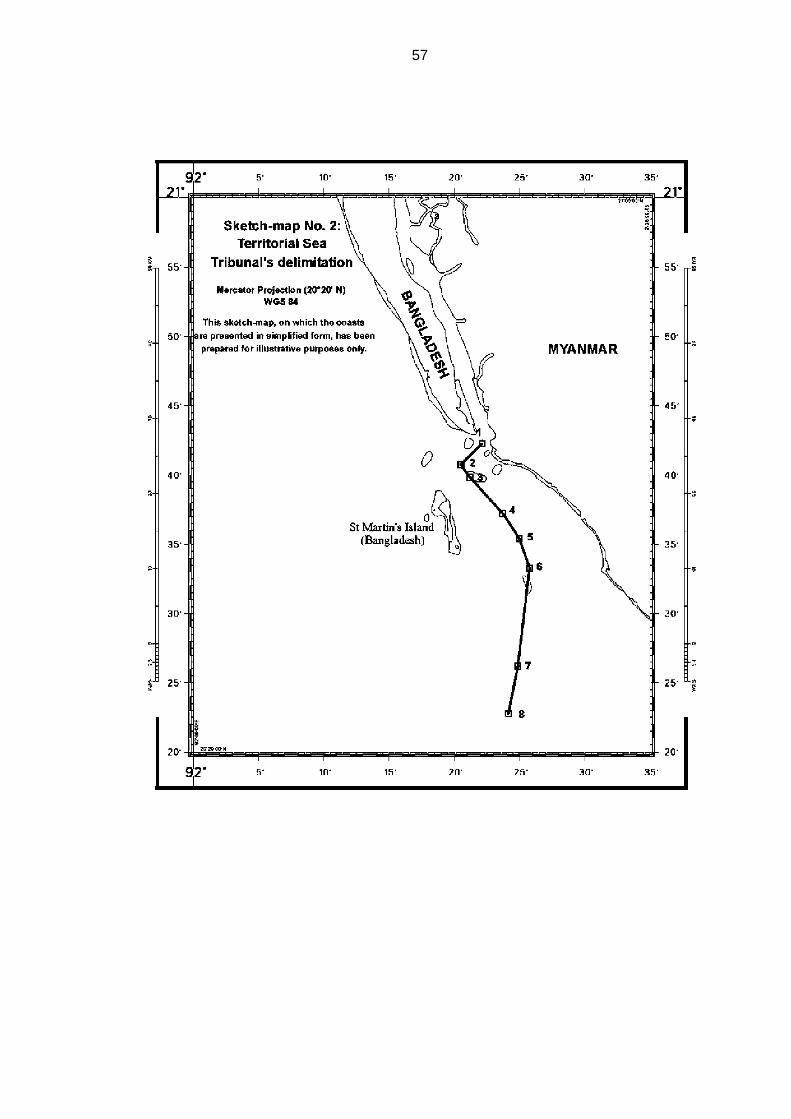
57

58
Right of passage of ships of Myanmar through the territorial sea
of Bangladesh around St. Martin’s Island
170. The question of free and unimpeded navigation by Myanmar in the
territorial sea of Bangladesh around St. Martin’s Island to and from the Naaf
River is not an issue to be considered in respect of delimitation. It is, however,
a related matter of particular concern to Myanmar.
171. In this context, the Tribunal requested the Parties to address the
following question: “Given the history of discussions between them on the
issue, would the Parties clarify their position regarding the right of passage of
ships of Myanmar through the territorial sea of Bangladesh around
St. Martin’s Island?”
172. Myanmar explained that it considered a guarantee of this right as
“crucially important” but that, in Myanmar’s view, Bangladesh had “never
given the guarantee that Myanmar sought”. Myanmar points out that there
had been no problems with access to Bangladesh’s territorial sea but mainly
because, “in the absence of any guarantee”, Myanmar had never sought to
put to test its right. Overall, Myanmar states that the “position on the right of
passage of ships of Myanmar through the territorial sea of Bangladesh around
St Martin’s Island continues to be less than satisfactory”.
173. On this issue, Bangladesh stated in its Memorial that “[a]s part of, and
in consideration for, their November 1974 agreement, Bangladesh also
agreed to accord Myanmar’s vessels the right of free and unimpeded
navigation through Bangladesh’s waters around St. Martin’s Island to and
from the Naaf River”.
174. In response to the request from the Tribunal, the Foreign Minister of
Bangladesh, its Agent in the present case, during the hearing stated the
following:

59
Since at least 1974 Bangladesh and Myanmar have engaged in extensive negotiations concerning their maritime boundary in the Bay of Bengal. Over the course of 34 years, our countries have conducted some 13 rounds of talks. We achieved some notable early successes. In particular, in 1974, at just our second round of meetings, we reached the agreement concerning the maritime boundary in the territorial sea, about which you will hear more tomorrow. That agreement was fully applied and respected by both States over more than three decades. As a result of that agreement, there have never been any problems concerning the right of passage of ships of Myanmar through our territorial sea around St Martin’s Island. In its two rounds of pleadings Myanmar had every opportunity to introduce evidence of any difficulties, if indeed there were any. It has not done so. That is because there are no difficulties. I am happy to restate that Bangladesh will continue to respect such access in full respect of its legal obligations.
175. Counsel for Bangladesh thereafter stated: “What the Foreign Minister
and Agent says in response to a direct question from an international tribunal
commits the State”.
176. The Tribunal takes note of this commitment by Bangladesh.
VIII. Exclusive economic zone and continental shelf within 200 nautical miles 177. The Tribunal will now turn to the delimitation of the exclusive economic
zone and the continental shelf within 200 nm.
Single delimitation line
178. Before proceeding with the delimitation of the exclusive economic zone
and the continental shelf, the Tribunal must clarify the nature of the
delimitation line.
179. Bangladesh states that the Tribunal should identify a single line to
delimit the seabed and subsoil and the superjacent waters. Bangladesh notes
that its position is “in accordance with the international judicial practice”.
According to Bangladesh, although the Convention contains separate
60
provisions for the delimitation of the exclusive economic zone and the
continental shelf, “international practice has largely converged around the
drawing of a ’single maritime boundary’ to delimit both zones”.
180. Myanmar, in turn, states that the Parties agree in asking the Tribunal to
draw a single maritime boundary for the superjacent waters, the seabed and
subsoil, that is, for the exclusive economic zone and the continental shelf.
181. The Tribunal accordingly will draw a single delimitation line for both the
exclusive economic zone and the continental shelf.
Applicable law
182. The Tribunal points out that the provisions of the Convention applicable
to the delimitation of the exclusive economic zone and the continental shelf
are in articles 74 and 83. The Tribunal observes that these two articles are
identical in their content, differing only in respect of the designation of the
maritime area to which they apply. These articles state as follows:
1. The delimitation of the [exclusive economic zone/continental shelf] between States with opposite or adjacent coasts shall be effected by agreement on the basis of international law, as referred to in article 38 of the Statute of the International Court of Justice, in order to achieve an equitable solution. 2. If no agreement can be reached within a reasonable period of time, the States concerned shall resort to the procedures provided for in Part XV. 3. Pending agreement as provided for in paragraph 1, the States concerned, in a spirit of understanding and cooperation, shall make every effort to enter into provisional arrangements of a practical nature and, during this transitional period, not to jeopardize or hamper the reaching of the final agreement. Such arrangements shall be without prejudice to the final delimitation. 4. Where there is an agreement in force between the States concerned, questions relating to the delimitation of the [exclusive economic zone/continental shelf] shall be determined in accordance with the provisions of that agreement.

61
183. Although article 74, paragraph 1, and article 83, paragraph 1, of the
Convention explicitly address delimitation agreements, they also apply to
judicial and arbitral delimitation decisions. These paragraphs state that
delimitation must be effected “on the basis of international law, as referred to
in article 38 of the Statute of the International Court of Justice, in order to
achieve an equitable solution”. Customary international law is one of the
sources identified in article 38. Accordingly, the law applicable under the
Convention with regard to delimitation of the exclusive economic zone and the
continental shelf includes rules of customary international law. It follows that
the application of such rules in the context of articles 74 and 83 of the
Convention requires the achievement of an equitable solution, as this is the
goal of delimitation prescribed by these articles.
184. Decisions of international courts and tribunals, referred to in article 38
of the Statute of the ICJ, are also of particular importance in determining the
content of the law applicable to maritime delimitation under articles 74 and 83
of the Convention. In this regard, the Tribunal concurs with the statement in
the Arbitral Award of 11 April 2006 that: “In a matter that has so significantly
evolved over the last 60 years, customary law also has a particular role that,
together with judicial and arbitral decisions, helps to shape the considerations
that apply to any process of delimitation” (Arbitration between Barbados and
the Republic of Trinidad and Tobago, relating to the delimitation of the
exclusive economic zone and the continental shelf between them, Decision of
11 April 2006, RIAA, Vol. XXVII, p. 147, at pp. 210-211, para. 223).
Relevant coasts
185. The Tribunal will now turn to the delimitation process. In examining this
issue, the Tribunal notes “the principle that the land dominates the sea
through the projection of the coasts or the coastal fronts” (Maritime
Delimitation in the Black Sea (Romania v. Ukraine), Judgment, I.C.J. Reports
2009, p. 61, at p. 89, para. 77). As stated by the ICJ in the North Sea cases,
“the land is the legal source of the power which a State may exercise over
62
territorial extensions to seaward” (North Sea Continental Shelf, Judgment,
I.C.J. Reports 1969, p. 3, at p. 51, paragraph 96).
186. Bangladesh is of the view that its entire coast is relevant “from the land
boundary terminus with Myanmar in the Naaf River to the land boundary
terminus with India in the Raimangal Estuary”.
187. Bangladesh measures this coast by means of two straight lines in order
to avoid the significant difficulties caused by the sinuosities of the coast.
According to Bangladesh, the combined length of these lines is
421 kilometres.
188. Myanmar describes the coast of Bangladesh as being made up of four
segments. The first segment proceeds in an easterly direction from the land
border with India to the mouth of the Meghna River. The fourth segment
proceeds in a south-southeasterly direction from the Lighthouse on Kutubdia
Island to the land border with Myanmar. Between these two segments lie the
second and third segments in the mouth of the Meghna River.
189. According to Myanmar, Bangladesh’s relevant coast is limited to the
first and fourth segments. Myanmar rejects the second and third segments as
parts of the relevant coast because those segments “face each other and
therefore cannot possibly overlap with Myanmar’s maritime projections”.
Myanmar compares these segments of Bangladesh’s coast to Ukraine’s
coasts in the Gulf of Karkinits’ka in the Black Sea case, in which the ICJ
excluded those coasts of Ukraine because they “face each other and their
submarine extension cannot overlap with the extensions of Romania’s coasts”
(Maritime Delimitation in the Black Sea (Romania v. Ukraine), Judgment,
I.C.J. Reports, 2009, p. 61, at p. 97, para. 100).
190. Measuring the coastal length by taking into account the coastline and
its sinuosity, Myanmar finds that the first and fourth segments of Bangladesh’s
coast are 203 kilometres and 161 kilometres long respectively. In Myanmar’s
view, the total length of Bangladesh’s relevant coast is 364 kilometres.

63
191. Bangladesh submits that the analogy between the mouth of the
Meghna River and the Gulf of Karkinits’ka is not accurate. In its view, while, in
the enclosed setting of the Black Sea, “the opening at the mouth of the Gulf of
Karkinits’ka faces back onto other portions of Ukraine’s coast, and not onto
the delimitation [area] […], [h]ere, in contrast, the opening at the mouth of the
Meghna faces directly onto the open sea and the delimitation [area]”.
According to Bangladesh, the opening at the mouth of the Meghna River is
much more like the opening at the mouth of the Bay of Fundy in the case
concerning Delimitation of the Maritime Boundary in the Gulf of Maine, in
which the Chamber of the ICJ deemed relevant “segments of Canada’s
parallel coasts within the Bay as well as the line drawn across the Bay inside
its mouth”.
192. According to Bangladesh, Myanmar’s relevant coast extends from the
land boundary terminus in the Naaf River to the area of Bhiff Cape.
Bangladesh regards Myanmar’s coast south of Bhiff Cape as irrelevant,
because, in its view, the projection of that coast, which is more than 200 nm
from Bangladesh, could not overlap with that of Bangladesh’s coast.
193. Bangladesh therefore maintains that Myanmar’s relevant coastal
length, measured by means of a straight line, is 370 kilometres.
194. Myanmar asserts that its own relevant coast extends from the land
boundary terminus between Myanmar and Bangladesh up to Cape Negrais. In
particular, Myanmar emphasizes that its “relevant coast does not stop near
Bhiff Cape”, but comprises the entire Rakhine (Arakan) coast, “from the Naaf
River to Cape Negrais, the last point on Myanmar’s coast generating maritime
projections overlapping with Bangladesh’s coastal projections”.
195. According to Myanmar, the arguments of Bangladesh to exclude the
coast below Bhiff Cape “are quite simply wrong. It is not the relevant area that
determines the relevant coast, it is the relevant coast that circumscribes the
area to be delimited”. Myanmar asserts further that:
64
the relevant coasts cannot depend, or be determined by reference to the delimitation line. They logically precede it, and it is the delimitation line that must be determined by reference to the relevant coasts and the projections that these generate. Bangladesh has put the cart before the horse.
196. Myanmar also points out that Bangladesh, according to its own
minutes, acknowledged during the negotiations between the Parties in
November 2008 that “the relevant coastline for Myanmar in the Bay of Bengal
is up to Cape Negrais”.
197. In Myanmar’s view, taking into account the coastline and its sinuosity,
the total length of its own relevant coast from the estuary of the Naaf River to
Cape Negrais is 740 kilometres.
* * *
198. The Tribunal notes at the outset that for a coast to be considered as
relevant in maritime delimitation it must generate projections which overlap
with those of the coast of another party.
199. The Parties are not in agreement in respect of the segments of
Bangladesh’s coastline formed by the eastern and western shores of the
Meghna River Estuary. They also disagree in respect of the segment of
Myanmar’s coast that runs from Bhiff Cape to Cape Negrais.
Bangladesh’s relevant coast
200. The Tribunal does not agree with Myanmar’s position that the eastern
and western shores of the Meghna River Estuary should not be treated as
part of the relevant coast. In the present case, the situation is different from
that of the Gulf of Karkinits’ka, where the coastal segments face each other.
The Meghna River Estuary is open to the sea and generates projections that
overlap with those of the coast of Myanmar. Accordingly, the shores of the

65
estuary must be taken into account in calculating the length of the relevant
coast of Bangladesh.
201. The Tribunal concludes that the whole of the coast of Bangladesh is
relevant for delimitation purposes, generating projections seaward that
overlap with projections from the coast of Myanmar. To avoid difficulties
caused by the complexity and sinuosity of that coast, it should be measured in
two straight lines.
202. The Tribunal draws the first line from a point on Bangladesh’s coast on
Mandabaria Island near the land boundary terminus with India, which was
used by Myanmar as a base point (ß2) for the construction of its proposed
equidistance line (see paragraph 243), to a point on Kutubdia Island (see
paragraph 188). The second line extends from the said point on Kutubdia
Island to the land boundary terminus with Myanmar in the Naaf River. As a
result, the length of Bangladesh’s relevant coast is approximately
413 kilometres.
Myanmar’s relevant coast
203. The Tribunal does not agree with Bangladesh’s position that
Myanmar’s coastline south of Bhiff Cape should not be included in the
calculation of Myanmar’s relevant coast. The Tribunal finds that the coast of
Myanmar from the terminus of its land boundary with Bangladesh to Cape
Negrais does, contrary to Bangladesh’s contention, indeed generate
projections that overlap projections from Bangladesh’s coast. The Tribunal,
therefore, determines that the coast of Myanmar from its land boundary
terminus with Bangladesh to Cape Negrais is to be regarded as Myanmar’s
relevant coast.
204. The Tribunal finds that Myanmar’s relevant coast should also be
measured by two lines so as to avoid difficulties caused by the sinuosity of the
coast and to ensure consistency in measuring the respective coasts of the
Parties. The first line is measured from the land boundary terminus in the

66
Naaf River to Bhiff Cape and the second line from this point to Cape Negrais.
Accordingly, the Tribunal concludes that the length of the relevant coast of
Myanmar, measured in two lines, is approximately 587 kilometres.
205. Having determined the relevant coasts of the Parties and their
approximate length, the Tribunal finds that the ratio between these coastal
lengths is approximately 1:1.42 in favour of Myanmar.
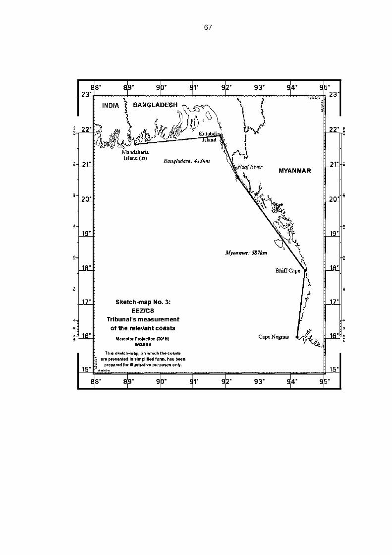
67

68
Method of delimitation
206. The Tribunal will now consider the method to be applied to the
delimitation of the exclusive economic zone and the continental shelf in the
case before it.
207. While the Parties agree that the provisions of the Convention
concerning the delimitation of the exclusive economic zone and the
continental shelf constitute the law applicable to the dispute between them,
they disagree as to the appropriate method of delimitation.
208. Bangladesh recognizes that the equidistance method is used in
appropriate circumstances as a means to achieve an equitable solution but
claims that equidistance does not produce an equitable result in the present
case.
209. Bangladesh challenges the validity of the equidistance method
advocated by Myanmar for the delimitation of the exclusive economic zone
and the continental shelf within 200 nm. It argues that the equidistance line is
inequitable in the present case, adding that Myanmar so completely embraces
the equidistance method as to go so far as to claim that “rights to maritime
areas are governed by equidistance” and to elevate equidistance, merely one
method of delimitation, into a rule of law of universal application.
210. Bangladesh observes that the use of the equidistance method “can
under certain circumstances produce results that appear on the face of them
to be extraordinary, unnatural or unreasonable” as stated in the North Sea
Continental Shelf cases (Judgment, I.C.J. Reports 1969, p. 3, at p. 23,
para. 24).
211. Bangladesh points out that concave coasts like those in the northern
Bay of Bengal are among the earliest recognized situations where
equidistance produces “irrational results” and refers in this regard to the case
concerning Continental Shelf (Libyan Arab Jamahiriya/Malta), in which the ICJ

69
stated that an equidistance line “may yield a disproportionate result where a
coast is markedly irregular or markedly concave or convex” (Judgment, I.C.J.
Reports 1985, p. 13, at p. 44, para. 56). In the same case the ICJ pointed out
that equidistance is “not the only method applicable […]” and it does “not even
have the benefit of a presumption in its favour” (ibid, p. 13, at p. 47, para. 63).
212. Bangladesh also points to the case concerning Territorial and Maritime
Dispute between Nicaragua and Honduras in the Caribbean Sea (Nicaragua
v. Honduras), in which the ICJ stated that the equidistance method “does not
automatically have priority over other methods of delimitation and, in particular
circumstances, there may be factors which make the application of the
equidistance method inappropriate” (Judgment, I.C.J. Reports 2007, p. 659, at
p. 741, para. 272).
213. Bangladesh argues that, on account of the specific configuration of its
coast in the northern part of the Bay of Bengal and of the double concavity
characterizing it, the Tribunal should apply the angle-bisector method in
delimiting the maritime boundary between Bangladesh and Myanmar in the
exclusive economic zone and on the continental shelf. In its view, this method
would eliminate the inequity associated with equidistance and lead to an
equitable result.
214. Bangladesh further states that the ICJ first made use of the angle-
bisector method in the case concerning Continental Shelf (Tunisia/Libyan
Arab Jamahiriya) in 1982 and that the 1984 decision of the Chamber of the
ICJ in the case concerning Delimitation of the Maritime Boundary in the Gulf
of Maine Area is another instance of resort to that method. Likewise, the
Arbitral Tribunal in the case concerning the Delimitation of the maritime
boundary between Guinea and Guinea-Bissau (Decision of 14 February 1985,
ILR, Vol. 77, p. 635) applied the angle-bisector method in delimiting the
maritime boundaries at issue.
215. Bangladesh also quotes the case concerning the Territorial and
Maritime Dispute between Nicaragua and Honduras in the Caribbean Sea

70
(Nicaragua v. Honduras) in support of its argument that the use of a bisector
“has proved to be a viable substitute method in certain circumstances where
equidistance is not possible or appropriate” (Judgment, I.C.J. Reports 2007,
p. 659, at p. 746, para. 287).
216. Bangladesh states that Myanmar’s claimed equidistance line is
inequitable because of the cut-off effect it produces. Bangladesh maintains
that, “[n]otwithstanding Bangladesh’s substantial 421 km coastline, the
equidistance lines claimed by its neighbours would prevent it from reaching
even its 200 [nm] limit, much less its natural prolongation in the outer
continental shelf beyond 200 [nm]”.
217. Bangladesh argues that the angle-bisector method, specifically the
215° azimuth line which it advocates for the delimitation of the maritime
boundary between Myanmar and itself on the continental shelf within 200 nm
and in the exclusive economic zone, “avoids the problems inherent in
equidistance without itself generating any inequities”.
218. In Myanmar’s view, the law of delimitation “has been considerably
completed, developed and made more specific” since the adoption of the
Convention in 1982. Myanmar contends that Bangladesh attempts to cast
doubt on the now well-established principles of delimitation of the exclusive
economic zone and the continental shelf. Myanmar further contends that
Bangladesh makes strenuous efforts to establish that the applicable law was
frozen in 1982 or, even better, in 1969, thus deliberately ignoring the
developments which have occurred over the past 40 years.
219. Myanmar states that "‘equidistance/relevant circumstances’ is not as
such a rule of delimitation properly said, but a method, usually producing an
equitable result”. Myanmar draws attention in this regard to the ICJ’s
judgment in the case concerning Territorial and Maritime Dispute between
Nicaragua and Honduras in the Caribbean Sea (Nicaragua v. Honduras)
(Judgment, I.C.J. Reports 2007, p. 659, at p. 741, para. 271).

71
220. Myanmar points out that, while Bangladesh relied on the judgment in
the case concerning Territorial and Maritime Dispute between Nicaragua and
Honduras in the Caribbean Sea (Nicaragua v. Honduras), where the ICJ held
that “the equidistance method does not automatically have priority over other
methods of delimitation”, it failed to mention that the ICJ said in the same
case: “[t]he jurisprudence of the Court sets out the reasons why the
equidistance method is widely used in the practice of maritime delimitation: it
has a certain intrinsic value because of its scientific character and the relative
ease with which it can be applied”. (Judgment, I.C.J. Reports 2007, p. 659, at
p. 741, para. 272). Myanmar adds that the ICJ in that same case applied the
bisector method only after finding it “impossible for the Court to identify base
points and construct a provisional equidistance line [...] delimiting maritime
areas off the Parties’ mainland coasts” (Ibid, p. 659, at p. 743, para. 280).
221. Myanmar further observes that in the case concerning Continental
Shelf (Libyan Arab Jamahiriya/Malta) the ICJ applied the
equidistance/relevant circumstances method even after noting that
equidistance “may yield a disproportionate result where a coast is markedly
irregular or markedly concave or convex” (Judgment, I.C.J Reports 1985,
p. 13, at p. 44, para. 56).
222. Myanmar requests the Tribunal to “apply the now well-established
method for drawing an all-purpose line for the delimitation of the maritime
boundary between the Parties". Myanmar asserts that “[i]n the present case,
no circumstance renders unfeasible the use of the equidistance method”. In
support of this request, it refers to the Black Sea case (Maritime Delimitation
in the Black Sea (Romania v. Ukraine), Judgment, I.C.J. Reports 2009, p. 61,
at p. 101, para. 116).
223. Myanmar rejects the arguments advanced by Bangladesh that the
equidistance line fails to take account of the relevant circumstances in the
case, notably the cut-off effect it produces and the concavity of Bangladesh’s
coast, and states that “[n]one of the reasons invoked by Bangladesh to set

72
aside the usual method of drawing the maritime boundary between States has
any basis in modern international law of the sea, the first step of which is to
identify the provisional equidistance line”.
224. In Myanmar’s view, the angle-bisector method advanced by
Bangladesh produces an inequitable result and Myanmar “firmly … reiterate[s]
that no reason whatsoever justifies recourse to the ‘angle-bisector method’ in
the present case".
* * *
225. The Tribunal observes that article 74, paragraph 1, and article 83,
paragraph 1, of the Convention stipulate that the delimitation of the exclusive
economic zone and the continental shelf respectively must be effected on the
basis of international law in order to achieve an equitable solution, without
specifying the method to be applied.
226. International courts and tribunals have developed a body of case law
on maritime delimitation which has reduced the elements of subjectivity and
uncertainty in the determination of maritime boundaries and in the choice of
methods employed to that end.
227. Beginning with the North Sea Continental Shelf cases, it was
emphasized in the early cases that no method of delimitation is mandatory,
and that the configuration of the coasts of the parties in relation to each other
may render an equidistance line inequitable in certain situations. This position
was first articulated with respect to the continental shelf, and was thereafter
maintained with respect to the exclusive economic zone as well.
228. Over time, the absence of a settled method of delimitation prompted
increased interest in enhancing the objectivity and predictability of the
process. The varied geographic situations addressed in the early cases
nevertheless confirmed that, even if the pendulum had swung too far away
from the objective precision of equidistance, the use of equidistance alone
73
could not ensure an equitable solution in each and every case. A method of
delimitation suitable for general use would need to combine its constraints on
subjectivity with the flexibility necessary to accommodate circumstances in a
particular case that are relevant to maritime delimitation.
229. In the case concerning Maritime Delimitation in the Area between
Greenland and Jan Mayen, the ICJ expressly articulated the approach of
dividing the delimitation process into two stages, namely “to begin with the
median line as a provisional line and then to ask whether 'special
circumstances' require any adjustment or shifting of that line” (Judgment,
I.C.J. Reports 1993, p. 38, at p. 61, para. 51). This general approach has
proven to be suitable for use in most of the subsequent judicial and arbitral
delimitations. As developed in those cases, it has come to be known as the
equidistance/relevant circumstances method.
230. In the case concerning Maritime Delimitation and Territorial Questions
between Qatar and Bahrain, the ICJ adopted the same approach (Merits,
Judgment, I.C.J. Reports 2001, p. 40, at p. 111, para. 230). In 2002, in the
case concerning the Land and Maritime Boundary between Cameroon and
Nigeria (Cameroon v. Nigeria: Equatorial Guinea intervening), the ICJ
confirmed its previous two-stage approach to the delimitation (Judgment,
I.C.J. Reports 2002, p. 303, at p. 441, para. 288).
231. The Arbitral Tribunal in the Arbitration between Barbados and the
Republic of Trinidad and Tobago, affirmed that “[t]he determination of the line
of delimitation [...] normally follows a two-step approach”, involving the
positing of a provisional line of equidistance and then examining it in the light
of the relevant circumstances. The Arbitral Tribunal further pointed out that
“while no method of delimitation can be considered of and by itself
compulsory, and no court or tribunal has so held, the need to avoid subjective
determinations requires that the method used start with a measure of certainty
that equidistance positively ensures, subject to its subsequent correction if
justified” (Decision of 11 April 2006, RIAA, Vol. XXVII, p. 147, at p.214,
para. 242, and at p. 230, para. 306).

74
232. Similarly, the Arbitral Tribunal in the case between Guyana and
Suriname noted:
The case law of the International Court of Justice and arbitral jurisprudence as well as State practice are at one in holding that the delimitation process should, in appropriate cases, begin by positing a provisional equidistance line which may be adjusted in the light of relevant circumstances in order to achieve an equitable solution (Arbitration between Guyana and Suriname, Award of 17 September 2007, ILM, Vol. 47 (2008), p. 116, at p. 213, para. 342).
233. In the Black Sea case, the ICJ built on the evolution of the
jurisprudence on maritime delimitation. In that case, the ICJ gave a
description of the three-stage methodology which it applied. At the first stage,
it established a provisional equidistance line, using methods that are
geometrically objective and also appropriate for the geography of the area to
be delimited. “So far as delimitation between adjacent coasts is concerned, an
equidistance line will be drawn unless there are compelling reasons that make
this unfeasible in the particular case” (Maritime Delimitation in the Black Sea
(Romania v. Ukraine), Judgment, I.C.J. Reports 2009, p. 61, at p. 101, para.
116). At the second stage, the ICJ ascertained whether “there are factors
calling for the adjustment or shifting of the provisional equidistance line in
order to achieve an equitable result” (ibid., at pp. 101, para. 120). At the third
stage, it verified that the delimitation line did not lead to “an inequitable result
by reason of any marked disproportion between the ratio of the respective
coastal lengths and the ratio between the relevant maritime area of each
State by reference to the delimitation line” (ibid.,at p. 103, para. 122).
234. The Tribunal notes that, as an alternative to the equidistance/relevant
circumstances method, where recourse to it has not been possible or
appropriate, international courts and tribunals have applied the angle-bisector
method, which is in effect an approximation of the equidistance method. The
angle-bisector method was applied in cases preceding the Libyan Arab
Jamahiriya/Malta judgment, namely, Continental Shelf (Tunisia/Libyan Arab
Jamahiriya) (Judgment, I.C.J. Reports 1982, p. 18, at p. 94, para. 133 (C) (3)),
75
Delimitation of the Maritime Boundary in the Gulf of Maine Area (Judgment,
I.C.J. Reports 1984, p. 246, at p. 333, para. 213), and Delimitation of the
Maritime Boundary between Guinea and Guinea-Bissau (Decision of 14
February 1985, ILR, Vol. 77, p. 635, at pp. 683-685, paras. 108-111). It was
more recently applied in the case concerning Territorial and Maritime Dispute
between Nicaragua and Honduras in the Caribbean Sea (Nicaragua v.
Honduras) (Judgment, I.C.J. Reports 2007, p. 659, at p. 741, para. 272 and at
p. 746, para. 287).
235. The Tribunal observes that the issue of which method should be
followed in drawing the maritime delimitation line should be considered in light
of the circumstances of each case. The goal of achieving an equitable result
must be the paramount consideration guiding the action of the Tribunal in this
connection. Therefore the method to be followed should be one that, under
the prevailing geographic realities and the particular circumstances of each
case, can lead to an equitable result.
236. When the angle bisector method is applied, the terminus of the land
boundary and the generalization of the direction of the respective coasts of
the Parties from that terminus determine the angle and therefore the direction
of the bisector. Different hypotheses as to the general direction of the
respective coasts of the Parties from the terminus of the land boundary will
often produce different angles and bisectors.
237. Bangladesh’s approach of constructing the angle at the terminus of the
land boundary between the Parties with reference to the ends of their
respective relevant coasts produces a markedly different bisector once it is
recognized that Myanmar’s relevant coast extends to Cape Negrais, as
decided by the Tribunal in paragraph 203. The resultant bisector fails to give
adequate effect to the southward projection of the coast of Bangladesh.
238. The Tribunal notes that jurisprudence has developed in favour of the
equidistance/relevant circumstances method. This is the method adopted by
76
international courts and tribunals in the majority of the delimitation cases that
have come before them.
239. The Tribunal finds that in the present case the appropriate method to
be applied for delimiting the exclusive economic zone and the continental
shelf between Bangladesh and Myanmar is the equidistance/relevant
circumstances method.
240. In applying this method to the drawing of the delimitation line in the
present case, the Tribunal, taking into account the jurisprudence of
international courts and tribunals on this matter, will follow the three stage-
approach, as developed in the most recent case law on the subject.
Accordingly, the Tribunal will proceed in the following stages: at the first stage
it will construct a provisional equidistance line, based on the geography of the
Parties’ coasts and mathematical calculations. Once the provisional
equidistance line has been drawn, it will proceed to the second stage of the
process, which consists of determining whether there are any relevant
circumstances requiring adjustment of the provisional equidistance line; if so,
it will make an adjustment that produces an equitable result. At the third and
final stage in this process the Tribunal will check whether the line, as
adjusted, results in any significant disproportion between the ratio of the
respective coastal lengths and the ratio of the relevant maritime areas
allocated to each Party.
Establishment of the provisional equidistance line
Selection of base points
241. The Tribunal will now proceed with the construction of its own
provisional equidistance line. The first step to be taken in this regard is to
select the base points for the construction of that line.
77
242. Bangladesh did not identify any base points, because it did not
construct a provisional equidistance line and therefore saw no need to select
base points on the Bangladesh or Myanmar coasts.
243. Myanmar identified two relevant base points on the coast of
Bangladesh “representing the most advanced part of the land (low water line)
into the sea”. These two base points are:
(β1) the closest point to the starting-point of the maritime boundary (Point A) located on the low water line of Bangladesh’s coast, base point β1 (co-ordinates 20°43’28.1”N, 92°19’40.1”E) […]; and (β2) the more stable point located on Bangladesh coast nearest to the land boundary with India, base point β2 (co-ordinates 21° 38’ 57.4” N, 89° 14’ 47.6” E).
244. Myanmar points out that base point β2 is, according to Bangladesh,
located on a coast characterized by a very active morpho-dynamism.
Myanmar notes that Bangladesh “expresses concern that ‘the location of base
point β2 this year might be very different from its location next year’”.
Myanmar adds that “it is difficult to detect any change in the location of β2 in
the sixteen years from 1973 to 1989”. Myanmar observes that satellite images
show that the β2 area is quite stable.
245. Myanmar identifies three base points on its own coast and describes
them as follows:
(μ1) at the mouth of the Naaf River, the closest point of the starting-point of the maritime boundary (Point A) located on the low water line of Myanmar’s coast, base point μ1 (co-ordinates 20° 41’ 28.2” N, 92° 22’ 47.8” E) […] (μ2) Kyaukpandu (Satoparokia) Point, located on the landward/low water line most seaward near Kyaukpandu Village, base point μ2 (co-ordinates 20° 33’ 02.5” N, 92° 31’ 17.6” E) […]. (μ3) at the mouth of the May Yu River (close to May Yu Point), base point μ3 (co-ordinates 20° 14’ 31.0” N, 92° 43’ 27.8” E) […].
246. Myanmar asserts that any base points on Bangladesh’s mainland coast
and coastal islands could be considered legally appropriate base points, but
because β1 is nearer to the provisional equidistance line, the other potential
78
base points are not relevant. Myanmar notes that on its own side the same is
true of base points on the coastal features south of base point µ3. These
potential base points on the coasts were eliminated on the basis of the
objective criterion of distance.
247. Myanmar states that several other base points were eliminated for
legal reasons. With reference to South Talpatty, Myanmar explains that it
could have been:
a potential source of relevant base points because of its relatively seaward location. Yet, as a legal matter, South Talpatty cannot be a source of base points for two reasons. First, the sovereignty of this feature is disputed between Bangladesh and India. Second, […] it is not clear whether the coastal feature - which may have existed in 1973 - still exists.
248. According to Myanmar, there is a second example of a set of coastal
features that are potential sources of relevant base points but were
nonetheless excluded from the calculation of the equidistance line. These are
“the low-tide elevations around the mouth of the Naaf River, the Cypress
Sands, and Sitaparokia Patches, off Myanmar’s coast”.
249. Myanmar points out that “[n]either Party used base points on those
low-tide elevations”, despite the fact that they are legitimate sources of base
points for measuring the breadth of the territorial sea and are nearer to the
territorial sea equidistance line than the base points on the mainland coasts.
Myanmar explains that these low-tide elevations are also nearer the
provisional equidistance line than either base point β1 or µ1.
Myanmar states
that “they cannot be used, as a legal matter,” for the purpose of constructing
the provisional equidistance line.
250. Myanmar submits that Myanmar’s May Yu Island and Bangladesh’s
St. Martin’s Island “must be eliminated as sources of base points”. Myanmar
acknowledges that both features are legitimate sources of normal baselines
for measuring the breadth of the territorial sea, and both would otherwise
have provided the nearest base points, that is, the relevant base points, for
79
the construction of the provisional equidistance line. Myanmar, however,
concludes that “the technical qualities of these features cannot overcome their
legal deficiencies”.
251. In the view of Myanmar, “the use of these anomalous features in the
construction of the provisional equidistance line would create a line that would
be […] ‘wholly inconsistent with the dominant geographic realities in the
area’”. Myanmar states that Bangladesh is correct in arguing that, if these
islands were used in the construction of the provisional equidistance line, the
entire course of that line would be determined by these two features alone.
252. Bangladesh maintains that:
Myanmar’s proposed equidistance line is also problematic because it is drawn on the basis of just four coastal base points, three on Myanmar’s coast and only one – base point β1 – on the Bangladesh coast, which Myanmar places very near the land boundary terminus between Bangladesh and Myanmar in the Naaf River.
253. According to Bangladesh, Myanmar “takes pains to make it appear as
though it actually uses two Bangladesh base points in the plotting of the
equidistance line”. Bangladesh contends that Myanmar does not “show the
effect of alleged base point β2 on its proposed delimitation line, because it
has none”. Bangladesh observes that “[b]ase point β2 never actually comes
into play in Myanmar’s proposed delimitation”.
254. Bangladesh asserts that it would be remarkable to base a delimitation
on a single coastal base point and that, after a review of the jurisprudence
and State practice, Bangladesh was unable to find even one example where a
delimitation extending so far from the coast was based on just one base point.
Bangladesh concludes by noting that, “in the Nicaragua v. Honduras case, the
ICJ drew a bisector precisely to avoid such a situation”.
255. In the view of Bangladesh, the lack of potential base points on the
Bangladesh coast is a function of the concavity of that coast and that after

80
base point β1, the coast recedes into the mouth of the Meghna estuary. It
adds that there is thus nothing to counteract the effect of Myanmar’s coast
south of the land boundary terminus and that the concavity of Bangladesh’s
coast results in there being no protuberant coastal base points.
256. Bangladesh points out that the consequence can be seen in the effect
of Myanmar’s equidistance line as it moves further and further from shore,
becoming, as a result, increasingly prejudicial to Bangladesh, and increasingly
inequitable.
257. Bangladesh contends that “[t]here is no legal basis for an a priori
assumption that St. Martin’s Island should be ignored in the drawing of
Myanmar’s equidistance line”. Bangladesh notes that St. Martin’s island “is a
significant coastal feature that indisputably generates entitlement in the
continental shelf and EEZ”. Bangladesh therefore concludes that “[t]here are
thus no grounds, other than Myanmar’s self-interest, for excluding it in the
plotting of a provisional equidistance line, where, in the first instance, all
coastal features are included”.
258. Myanmar responds that five base points were sufficient in the Black
Sea case to delimit a boundary stretching well over 100 nm from start to
finish. It states that in other delimitations, especially those between adjacent
coasts, even fewer base points have been used: three base points were used
for the 170 nm western section of the boundary in the Delimitation of the
Continental Shelf between United Kingdom of Great Britain and Northern
Ireland, and the French Republic (Decision of 30 June 1977, RIAA, Vol. XVIII,
p. 3, Annex, Technical Report to the Court, p. 126, at pp. 128-129), and just
two base points were used to construct the provisional equidistance line in the
case concerning the Land and Maritime Boundary between Cameroon and
Nigeria (Cameroon v. Nigeria: Equatorial Guinea intervening) (Merits,
Judgment, I.C.J. Reports 2002, p. 303, at p. 443, para. 292).
* * *
81
259. The Tribunal will first select the base points to be used for constructing
the provisional equidistance line.
260. As noted in paragraph 242, Bangladesh did not identify any base
points for the construction of a provisional equidistance line.
261. The Tribunal notes Bangladesh’s contentions that Myanmar does not
show the effect on its proposed delimitation line of base point β2, located on
the southern tip of Mandabaria Island, near the land boundary between
Bangladesh and India, because that point has none, and that base point β2
never actually comes into play in Myanmar’s proposed delimitation.
262. The Tribunal further notes that the observation made by Bangladesh
concerning Myanmar’s β2 base point does not amount to a disagreement with
the selection of that point; rather, it is a criticism by Bangladesh that Myanmar
does not use that base point in its construction of the equidistance line.
263. The Tribunal notes that, while Bangladesh argues that the number of
base points selected by Myanmar is insufficient for the construction of an
equidistance line, Bangladesh does not question the five base points selected
by Myanmar.
264. The Tribunal observes that, while coastal States are entitled to
determine their base points for the purpose of delimitation, the Tribunal is not
obliged, when called upon to delimit the maritime boundary between the
parties to a dispute, to accept base points indicated by either or both of them.
The Tribunal may establish its own base points, on the basis of the
geographical facts of the case. As the ICJ stated in the Black Sea case:
[i]n […] the delimitation of the maritime areas involving two or more States, the Court should not base itself solely on the choice of base points made by one of those Parties. The Court must, when delimiting the continental shelf and the exclusive economic zones, select base points by reference to the physical geography of the relevant coasts (Maritime Delimitation in the Black Sea

82
(Romania v. Ukraine), Judgment, I.C.J. Reports 2009, p. 61, at p. 108, para. 137).
265. Concerning the question whether St. Martin’s Island could serve as the
source of a base point, the Tribunal is of the view that, because it is located
immediately in front of the mainland on Myanmar’s side of the Parties’ land
boundary terminus in the Naaf River, the selection of a base point on St.
Martin’s Island would result in a line that blocks the seaward projection from
Myanmar’s coast. In the view of the Tribunal, this would result in an
unwarranted distortion of the delimitation line, and amount to “a judicial
refashioning of geography” (ibid., at p. 110, para. 149). For this reason, the
Tribunal excludes St. Martin’s Island as the source of any base point.
266. The Tribunal is satisfied that the five base points selected by Myanmar
are the appropriate base points on the coasts of the Parties for constructing
the provisional equidistance line. In addition, the Tribunal selects a new base
point μ4, which is appropriate for the last segment of the provisional
equidistance line. This base point is identified on the basis of the Admiralty
Chart 817 and is situated on the southern tip of the island of Myay Ngu Kyun,
at Boronga Point. Its coordinates are: 19° 48’ 49.8” N, 93° 01’ 33.6” E. The
Tribunal will start the construction of a provisional equidistance line by using
the following base points:
On the coast of Myanmar:
µ1: 20° 41’ 28.2” N, 92° 22’ 47.8” E;
µ2: 20° 33’ 02.5” N, 92° 31’ 17.6” E;
µ3: 20° 14’ 31.0” N, 92° 43’ 27.8” E; and
μ4: 19° 48’ 49.8” N, 93° 01’ 33.6” E.
On the coast of Bangladesh:
β1: 20° 43’ 28.1” N, 92° 19’ 40.1” E; and
β2: 21° 38’ 57.4” N, 89° 14’ 47.6” E.
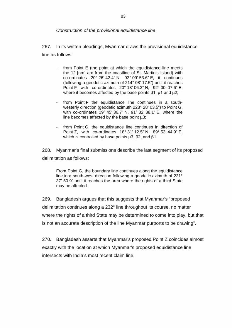
83
Construction of the provisional equidistance line
267. In its written pleadings, Myanmar draws the provisional equidistance
line as follows:
- from Point E (the point at which the equidistance line meets
the 12-[nm] arc from the coastline of St. Martin’s Island) with co-ordinates 20° 26’ 42.4” N, 92° 09’ 53.6” E, it continues (following a geodetic azimuth of 214° 08’ 17.5”) until it reaches Point F with co-ordinates 20° 13’ 06.3” N, 92° 00’ 07.6” E, where it becomes affected by the base points β1, µ1 and µ2;
- from Point F the equidistance line continues in a south-
westerly direction (geodetic azimuth 223° 28’ 03.5”) to Point G, with co-ordinates 19° 45’ 36.7” N, 91° 32’ 38.1” E, where the line becomes affected by the base point µ3;
- from Point G, the equidistance line continues in direction of
Point Z, with co-ordinates 18° 31’ 12.5” N, 89° 53’ 44.9” E, which is controlled by base points µ3, β2, and β1.
268. Myanmar’s final submissions describe the last segment of its proposed
delimitation as follows: From Point G, the boundary line continues along the equidistance line in a south-west direction following a geodetic azimuth of 231° 37’ 50.9” until it reaches the area where the rights of a third State may be affected.
269. Bangladesh argues that this suggests that Myanmar’s “proposed
delimitation continues along a 232° line throughout its course, no matter
where the rights of a third State may be determined to come into play, but that
is not an accurate description of the line Myanmar purports to be drawing”.
270. Bangladesh asserts that Myanmar’s proposed Point Z coincides almost
exactly with the location at which Myanmar’s proposed equidistance line
intersects with India’s most recent claim line.
84

85
* * *
271. The Tribunal will now construct its provisional equidistance line from
base points situated on the coasts of the Parties. For this purpose, it will
employ the base points it identified in paragraph 266.
272. The provisional equidistance line starts at a point in the Naaf River
lying midway between the closest base points on the coasts of the Parties,
namely point ß1 on the Bangladesh coast and point µ1 on the Myanmar
coast. The coordinates of the starting point are 20°
42’ 28.2” N,
92° 21’ 14.0” E.
273. The provisional equidistance line within 200 nm from the baselines
from which the territorial seas of the Parties are measured is defined by the
following turning points at which the direction of the line changes and which
are connected by geodetic lines:
- point T1 which is controlled by base points β1, µ1 and µ2 and
which has the coordinates 20° 13’ 06.3’’ N, 92° 00’ 07.6’’ E;
- point T2 which is controlled by base points β1, µ2 and µ3 and
which has the coordinates 19° 45’ 36.7’’ N, 91° 32’ 38.1’’ E; and
- point T3 which is controlled by base points β1, β2 and µ3 and which
has the coordinates 18° 31’ 12.5’’ N, 89° 53’ 44.9’’ E.
274. From turning point T3, the course of the provisional equidistance line
within 200 nm from the baselines of the Parties from which their territorial
seas are measured comes under the influence of the additional new base
point μ4, as identified by the Tribunal. From turning point T3, the provisional
equidistance line follows a geodetic line starting at an azimuth of 202° 56’ 22”
until it reaches the limit of 200 nm.
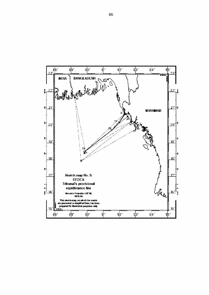
86
87
Relevant circumstances
275. Having drawn the provisional equidistance line, the Tribunal will now
consider whether there are factors in the present case that may be considered
relevant circumstances, calling for an adjustment of that line with a view to
achieving an equitable solution. The Tribunal notes in this regard that the
Parties differ on the issue of relevant circumstances.
276. Bangladesh points out three main geographical and geological features
that characterize the present case and are relevant to the delimitation in
question. The first of these is the “concave shape of Bangladesh’s coastline”,
extending from the land boundary terminus with India in the west to the land
boundary terminus with Myanmar in the east. The Bangladesh coast is further
marked by “a second concavity, that is a concavity within the overall concavity
of its coastline”. The second major geographical feature is St. Martin’s Island,
a significant coastal island lying within 5 nm of the Bangladesh mainland. The
third major distinguishing feature is the Bengal depositional system, which
comprises “both the landmass of Bangladesh and its uninterrupted geological
prolongation into and throughout the Bay of Bengal”.
277. Bangladesh maintains that “it is not possible to delimit the boundary in
a manner that achieves an equitable solution without taking each of these
three features duly into account”. In Bangladesh’s view, these features should
be taken into account “as a relevant circumstance in fashioning an equitable
delimitation within 200 miles, and should inform the delimitation of the outer
continental shelf as between Bangladesh and Myanmar beyond 200 miles”.
278. For its part, Myanmar contends that “there does not exist any relevant
circumstance that may lead to an adjustment of the provisional equidistance
line”.
88
Concavity and cut-off effect
279. Bangladesh argues that “[t]he effect of the double concavity is to push
the two equidistance lines between Bangladesh and its neighbours together”,
and that it “is not only left with a wedge of maritime space that narrows
dramatically to seaward but it is also stopped short of its 200-[nm] limit”.
280. Bangladesh observes that “Myanmar deploys two, not entirely
consistent, arguments to deny [the] relevance [of the concavity]”, namely, first
that “there is no appreciable concavity and, second, that the concavity is
legally irrelevant in any event”. Bangladesh is of the view that “[b]oth
assertions are incorrect”.
281. With respect to the first argument, Bangladesh points out that it
contradicts what Myanmar said in its own Counter-Memorial, which expressly
acknowledged the doubly concave nature of Bangladesh’s coast.
282. As to the second argument, Bangladesh observes that the only
ostensible jurisprudential basis for this claim of Myanmar is the ICJ’s decision
in Cameroon v. Nigeria. Bangladesh points out that while, in that case, the ICJ
found expressly that the portion of the coast relevant to the delimitation was
not concave, it also stated that “[t]he Court does not deny that the concavity of
the coastline may be a circumstance relevant to the delimitation” (Land and
Maritime Boundary between Cameroon and Nigeria (Cameroon v. Nigeria:
Equatorial Guinea intervening), Judgment, I.C.J. Reports 2002, p. 303, at
p. 445, para. 297).
283. Bangladesh submits that the cut-off effect is as prejudicial to it as was
the cut-off effect to Germany in the North Sea cases and that “[t]he reality is
then that equidistance threatens Bangladesh with a more severe cut-off than
Germany”.
284. Bangladesh also relies on the award in the case concerning
Delimitation of the maritime boundary between Guinea and Guinea-Bissau,
89
noting that, although in that case “[t]he equidistance lines between Guinea
and its two neighbours did not fully cut Guinea off within 200 miles”, […] “the
relief the tribunal gave Guinea is considerable, certainly far greater than
anything that Bangladesh is seeking in this case”.
285. Bangladesh draws attention to State practice in instances where a
State is “pinched” in the middle of a concavity and would have been cut off,
had the equidistance method been used, and “[t]he maritime boundaries that
were ultimately agreed discarded equidistance in order to give the middle
State access to its 200-[nm] limit”. It refers in this regard to the 1975 agreed
delimitation between Senegal and The Gambia on the coast of West Africa,
the 1987 agreed boundaries in the Atlantic Ocean between Dominica and the
French islands of Guadeloupe and Martinique, the 1984 agreement between
France and Monaco, the 2009 memorandum of understanding between
Malaysia and Brunei, and the 1990 agreement between Venezuela and
Trinidad and Tobago.
286. In response to Myanmar’s assertion that, as political compromises,
“these agreements have no direct applicability to the questions of law now
before the Tribunal”, Bangladesh argues that “[i]t is impossible not to draw the
conclusion that these agreements, collectively or individually, evidence a
broad recognition by States in Africa, in Europe, in the Americas, and in the
Caribbean that the equidistance method does not work in the case of States
trapped in the middle of a concavity”.
287. In relation to Myanmar’s reference to “the practice in the region” – the
1978 agreements among India, Indonesia and Thailand in the Andaman Sea;
the 1971 agreement among Indonesia, Malaysia and Thailand in the Northern
Part of the Strait of Malacca; and the 1993 agreement among Myanmar, India
and Thailand in the Andaman Sea – as support for the contention that cut-offs
within 200 miles are common, Bangladesh maintains that these agreements
do not support Myanmar’s proposition.

90
288. While recognizing that it is a fact that the “coastlines of Bangladesh
taken as a whole are concave”, Myanmar states that “the resulting enclaving
effect is not as dramatic as Bangladesh claims” and that “there does not exist
any relevant circumstance that may lead to an adjustment of the provisional
equidistance line”. It observes in this regard that “[u]nless we completely
refashion nature […] this concavity cannot be seen as a circumstance calling
for a shift of the equidistance line”.
289. Myanmar submits that the test of proportionality – or, more precisely,
the absence of excessive disproportionality – confirms the equitable character
of the solution resulting from the provisional equidistance line. It further
argues that this line drawn in the first stage of the equidistance/relevant
circumstances method meets the requirement of an equitable solution
imposed by articles 74 and 83 of the Convention. Therefore, it is not
necessary to modify or adjust it in the two other stages.
* * *
290. The Tribunal will now consider whether the concavity of the coast of
Bangladesh constitutes a relevant circumstance warranting an adjustment of
the provisional equidistance line.
291. The Tribunal observes that the coast of Bangladesh, seen as a whole,
is manifestly concave. In fact, Bangladesh’s coast has been portrayed as a
classic example of a concave coast. In the North Sea cases, the Federal
Republic of Germany specifically invoked the geographical situation of
Bangladesh (then East Pakistan) to illustrate the effect of a concave coast on
the equidistance line (I.C.J. Pleadings, North Sea Continental Shelf, Vol. I,
p. 42).
292. The Tribunal notes that in the delimitation of the exclusive economic
zone and the continental shelf, concavity per se is not necessarily a relevant
circumstance. However, when an equidistance line drawn between two States
produces a cut-off effect on the maritime entitlement of one of those States,

91
as a result of the concavity of the coast, then an adjustment of that line may
be necessary in order to reach an equitable result.
293. The Tribunal further notes that, on account of the concavity of the coast
in question, the provisional equidistance line it constructed in the present case
does produce a cut-off effect on the maritime projection of Bangladesh and
that the line if not adjusted would not result in achieving an equitable solution,
as required by articles 74 and 83 of the Convention.
294. This problem has been recognized since the decision in the North Sea
cases, in which the ICJ explained that “it has been seen in the case of
concave or convex coastlines that if the equidistance method is employed,
then the greater the irregularity and the further from the coastline the area to
be delimited, the more unreasonable are the results produced. So great an
exaggeration of the consequences of a natural geographical feature must be
remedied or compensated for as far as possible, being of itself creative of
inequity” (North Sea Continental Shelf, Judgment, I.C.J. Reports 1969, p. 3, at
p. 49, para. 89).
295. In this regard, the ICJ observed that “in the case of a concave or
recessing coast […], the effect of the use of the equidistance method is to pull
the line of the boundary inwards, in the direction of the concavity”, causing the
area enclosed by the equidistance lines “to take the form approximately of a
triangle with its apex to seaward and, as it was put on behalf of the Federal
Republic, ‘cutting off’ the coastal State from the further areas of the
continental shelf outside of and beyond this triangle” (ibid., at p. 17, para. 8).
296. Likewise, in the case concerning the Delimitation of the Maritime
Boundary Between Guinea and Guinea-Bissau, the Arbitral Tribunal stated
that “[w]hen in fact […] there are three adjacent States along a concave
coastline, the equidistance method has the other drawback of resulting in the
middle country being enclaved by the other two and thus prevented from
extending its maritime territory as far seaward as international law permits”.
(Decision of 14 February 1985, ILR, Vol. 77, p. 635, at p. 682, para. 104)

92
297. The Tribunal finds that the concavity of the coast of Bangladesh is a
relevant circumstance in the present case, because the provisional
equidistance line as drawn produces a cut-off effect on that coast requiring an
adjustment of that line.
St. Martin’s Island
298. Bangladesh argues that St. Martin’s Island is one of the important
geographical features in the present case and that “[a]ny line of delimitation
that would ignore [this island] is inherently and necessarily inequitable”.
299. Bangladesh maintains that “if, contrary to [its] view, equidistance is not
rejected,” then St Martin’s Island must be given full weight in any solution
based on an equidistance line and “that even this is not enough to achieve the
equitable solution that is required by the 1982 Convention”.
300. Bangladesh submits that, “whether or not an island can be
characterized as being ‘in front of’ one coast or another does not in itself
determine whether it is a special or a relevant circumstance”. It refers in this
regard to the Case concerning the Delimitation of the Continental Shelf
between United Kingdom of Great Britain and Northern Ireland, and the
French Republic, in which the Court of Arbitration observed that the pertinent
question is whether an island would produce “an inequitable distortion of the
equidistance line producing disproportionate effects on the areas of shelf
accruing to the two States” (Decision of 30 June 1977, RIAA, Vol. XVIII, p. 3,
at p. 113, para. 243).
301. Bangladesh submits that “St. Martin’s Island is as much in front of the
Bangladesh coast as it is in front of Myanmar’s coast” and states that the case
law supports this view. In this regard Bangladesh notes that Myanmar
describes the French island of Ushant as being located in front of the French
coast, when in fact Ushant lies 10 miles off France’s Brittany coast, further

93
than St. Martin’s Island is from Bangladesh, and observes moreover that the
Scilly Isles are 21 miles off the United Kingdom coast.
302. Bangladesh states that “Myanmar’s proposition that a finding of special
or relevant circumstance is more likely when an island lies closer to the
mainland is wrong” and that, “[i]n fact, it is when islands lie outside a State’s
12-[nm] territorial sea that they have been treated as relevant circumstances
and given less than full effect in the [exclusive economic zone] and
continental shelf delimitations”.
303. Bangladesh contends that what really matters is a “contextualized
assessment” of an island’s effect in the particular circumstances of a given
case and that, to the contrary of what Myanmar claims, it is the elimination of
St. Martin’s Island that disproportionately affects Myanmar’s delimitation
exercise, and renders it even more inequitable than it already is.
304. Responding to Myanmar’s contention that no island in a position
analogous to that of St. Martin's Island has ever been considered as a
relevant circumstance, Bangladesh, citing jurisprudence in support, states
that:
[t]his is the effect, or the lack of effect, that was given to the following islands:
- the Channel Islands in the case of Delimitation of the continental shelf between France and the United Kingdom in 1977; - the island of Djerba in the case of Tunisia v. Libya settled in 1982; - the island of Filfla in the case of Libya v. Malta settled in 1985; - the island of Abu Musa in the award between Dubai and Sharjah in 1981;
- the Yemeni Islands in the arbitration between Eritrea v. Yemen in 1999; - the island of Qit at Jaradah in the case of Qatar v. Bahrain in 2001;
94
- Sable Island in the arbitration of 2002 between the province of Newfoundland and Labrador; - Serpent’s Island in the case of Romania v. Ukraine in 2009; - and the cays in the case of Nicaragua v. Honduras in 2007.
305. Bangladesh notes that the ICJ and arbitral tribunals have developed a
clear and common approach to the determination of whether an island exerts
such a distorting effect on the provisional equidistance line and must be
disregarded or given less than full weight in the delimitation.
306. Bangladesh explains further that “[t]wo elements are required” for the
island to be disregarded or given less than full weight:
(1) the deflection of the equidistance line directly across another State’s coastal front; and (2) the cut-off of that State’s seaward access.
307. Bangladesh is of the view that a provisional equidistance line that
includes St. Martin’s “does cut across somebody’s coastal front, and does
cause a significant cut-off effect – but the effect is not on Myanmar”. It is for
Bangladesh, not Myanmar, that the provisional equidistance line needs to be
adjusted so as to achieve the equitable solution required by the Convention.
308. Bangladesh explains that the pertinent question is not whether a
particular feature affects the provisional equidistance line but whether it
distorts the line and concludes by stating that “St Martin’s does not distort the
line”.
309. Myanmar, in turn, emphasizes “the unique position of St Martin's
Island, which has three characteristic elements: it is close to the land
boundary and therefore to the starting point of the equidistance line; it has the
very exceptional feature of being on the wrong side of the equidistance line
and also on the wrong side of the bisector claimed by Bangladesh; and,
finally, the mainland coasts to be delimited are adjacent, not opposite”.
95
Myanmar contends that “[t]hose three elements together create a serious,
very excessive distorting effect on delimitation”.
310. Myanmar notes that “Bangladesh has never included St. Martin’s
Island in its coastal façade or in the description of its relevant coast”,
Myanmar points out that Bangladesh had stated in its Reply that “its relevant
coast extends, from west to east, from the land boundary terminus with India
to the land boundary terminus on the other side on the Naaf River” and had
not mentioned St. Martin's Island. Myanmar points out in this regard that “[t]his
makes even more curious the claim made […] that the island is ‘an integral
part of the Bangladesh coast’”.
311. Myanmar observes that the location of St. Martin’s Island and the effect
that it produces “make it a special circumstance in the case of the delimitation
of the territorial sea”, which explains the care taken by Myanmar to give it the
effect that is most appropriate to its unique location; and “the same
considerations lead to it not being accorded more effect in the framework of
the delimitation of the exclusive economic zones”.
312. On the issue of the effect that islands have on delimitation of the
exclusive economic zone and the continental shelf, Myanmar points out that if
one looks “closely at how case law has applied the methodology, [...] no
island in the position of St Martin's Island has ever been considered, in the
first stage of the process, as an island that should have effect in drawing an
equidistance line beyond the territorial sea, or in the second stage of the
process as a relevant circumstance”.
313. Myanmar asserts that “[i]n almost all the cases that have been
adjudged, the islands in question [...] have not been considered to be coastal
islands” and “were not given any effect on the construction of the equidistance
line beyond the territorial sea”.
314. Myanmar points out that St. Martin’s Island, which is 5 kilometres long,
would by itself generate at least 13,000 square kilometres of maritime area for
96
Bangladesh in the framework of the delimitation between continental masses,
a result which, according to Myanmar, is manifestly disproportionate.
315. Myanmar argues that “if […] effect were to be given to St. Martin’s
Island” in the delimitation of the exclusive economic zone and the continental
shelf between Myanmar and Bangladesh, “this would produce a
disproportionate result”, citing the Dubai/Sharjah Border Arbitration (Award of
19 October 1981, ILR, Vol. 91, p. 543, at p. 677), the case concerning the
Continental Shelf (Libyan Arab Jamahiriya/Malta) (Judgment, I.C.J. Reports
1985, p. 13, at p. 48, para. 64), the case concerning Maritime Delimitation and
Territorial Questions between Qatar and Bahrain (Merits, Judgment, I.C.J.
Reports 2001, p. 40, at pp. 104-109, para. 219) and the Black Sea case
(Maritime Delimitation in the Black Sea (Romania v. Ukraine), Judgment,
I.C.J. Reports 2009, p. 61, at p. 122-128, para. 185).
* * *
316. The Tribunal will now consider whether St. Martin’s Island, in the
circumstances of this case, should be considered a relevant circumstance
warranting an adjustment of the provisional equidistance line.
317. The Tribunal observes that the effect to be given to an island in the
delimitation of the maritime boundary in the exclusive economic zone and the
continental shelf depends on the geographic realities and the circumstances
of the specific case. There is no general rule in this respect. Each case is
unique and requires specific treatment, the ultimate goal being to reach a
solution that is equitable.
318. St. Martin’s Island is an important feature which could be considered a
relevant circumstance in the present case. However, because of its location,
giving effect to St. Martin’s Island in the delimitation of the exclusive economic
zone and the continental shelf would result in a line blocking the seaward
projection from Myanmar’s coast in a manner that would cause an
unwarranted distortion of the delimitation line. The distorting effect of an island
97
on an equidistance line may increase substantially as the line moves beyond
12 nm from the coast.
319. For the foregoing reasons, the Tribunal concludes that St. Martin’s
Island is not a relevant circumstance and, accordingly, decides not to give any
effect to it in drawing the delimitation line of the exclusive economic zone and
the continental shelf.
Bengal depositional system
320. As regards the Bengal depositional system, Bangladesh states that the
physical, geological and geomorphological connection between Bangladesh’s
land mass and the Bay of Bengal sea floor is so clear, so direct and so
pertinent, that adopting a boundary in the area within 200 nm that would cut
off Bangladesh, and deny it access to, and rights in the area beyond, would
constitute a grievous inequity.
321. Myanmar rejects Bangladesh’s contention that the Bengal depositional
system is a relevant circumstance, stating that this is a “very curious” special
circumstance. It points out that Bangladesh itself admits that within 200 nm
entitlement is, by operation of article 76, paragraph 1, of the Convention,
determined purely by reference to distance from the coast.
* * *
322. The Tribunal does not consider that the Bengal depositional system is
relevant to the delimitation of the exclusive economic zone and the continental
shelf within 200 nm. The location and direction of the single maritime
boundary applicable both to the seabed and subsoil and to the superjacent
waters within the 200 nm limit are to be determined on the basis of geography
of the coasts of the Parties in relation to each other and not on the geology or
geomorphology of the seabed of the delimitation area.

98
Adjustment of the provisional equidistance line
323. As noted by the Tribunal in paragraph 291, the coast of Bangladesh
between its land boundary terminus with Myanmar at the mouth of the Naaf
River and its land boundary terminus with India is decidedly concave. This
concavity causes the provisional equidistance line to cut across Bangladesh’s
coastal front. This produces a pronounced cut-off effect on the southward
maritime projection of Bangladesh’s coast that continues throughout much of
the delimitation area.
324. The Tribunal recalls that it has decided earlier in this Judgment (see
paragraph 297) that the concavity which results in a cut-off effect on the
maritime projection of Bangladesh is a relevant circumstance, requiring an
adjustment of the provisional equidistance line.
325. The Tribunal, therefore, takes the position that, while an adjustment
must be made to its provisional equidistance line to abate the cut-off effect of
the line on Bangladesh’s concave coast, an equitable solution requires, in
light of the coastal geography of the Parties, that this be done in a balanced
way so as to avoid drawing a line having a converse distorting effect on the
seaward projection of Myanmar’s coastal façade.
326. The Tribunal agrees that the objective is a line that allows the relevant
coasts of the Parties “to produce their effects, in terms of maritime
entitlements, in a reasonable and mutually balanced way” (Maritime
Delimitation in the Black Sea (Romania v. Ukraine), Judgment, I.C.J. Reports
2009, p. 61, at p. 127, para. 201).
327. The Tribunal notes that there are various adjustments that could be
made within the relevant legal constraints to produce an equitable result. As
the Arbitral Tribunal observed in the Arbitration between Barbados and
Trinidad and Tobago, “[t]here are no magic formulas” in this respect (Decision
of 11 April 2006, RIAA, Vol. XXVII, p. 147, at p. 243, para. 373).
99
328. In the case concerning the Continental Shelf (Libyan Arab
Jamahiriya/Malta) the position of the line but not its direction was adjusted, in
the case concerning Maritime Delimitation in the Area between Greenland
and Jan Mayen the position and direction of the line were adjusted, and in the
Arbitration between Barbados and the Republic of Trinidad and Tobago, the
line was deflected at the point suggested by the relevant circumstances, and
its direction was determined in light of those circumstances. The approach
taken in this arbitration would appear to be suited to the geographic
circumstances of the present case, which entails a lateral delimitation line
extending seaward from the coasts of the Parties.
329. The Tribunal decides that, in view of the geographic circumstances in
the present case, the provisional equidistance line is to be deflected at the
point where it begins to cut off the seaward projection of the Bangladesh
coast. The direction of the adjustment is to be determined in the light of those
circumstances.
330. The fact that this adjustment may affect most of the line in the present
case is not an impediment, so long as the adjustment is tailored to the
relevant circumstance justifying it and the line produces an equitable solution.
The Tribunal notes that in the Arbitration between Barbados and the Republic
of Trinidad and Tobago it was concluded that only part of the line required
adjustment, while the ICJ adjusted the lines in their entirety in the cases
concerning the Continental Shelf (Libyan Arab Jamahiriya/Malta) and
Maritime Delimitation in the Area between Greenland and Jan Mayen.
331. The Tribunal, therefore, determines that the adjustment of the
provisional equidistance line should commence at point X with coordinates
20° 03’ 32.0” N, 91°50’ 31.8” E, where the equidistance line begins to cut off
the southward projection of the coast of Bangladesh. The Tribunal has
selected the point on the provisional equidistance line that is due south of the
point on Kutubdia Island at which the direction of the coast of Bangladesh
shifts markedly from north-west to west, as indicated by the lines drawn by the
Tribunal to identify the relevant coasts of Bangladesh.
100
332. Having concluded that the overlapping projections from the coasts of
the Parties extend to the limits of their respective exclusive economic zones
and continental shelves outside the area in which a third party may have
rights, the Tribunal considered how to make the adjustment to the provisional
equidistance line in that light.
333. The projection southward from the coast of Bangladesh continues
throughout the delimitation area. There is thus a continuing need to avoid cut-
off effects on this projection. In the geographic circumstances of this case it is
not necessary to change the direction of the adjusted line as it moves away
from the coasts of the Parties.
334. The Tribunal accordingly believes that there is reason to consider an
adjustment of the provisional equidistance line by drawing a geodetic line
starting at a particular azimuth. In the view of the Tribunal the direction of any
plausible adjustment of the provisional equidistance line would not differ
substantially from a geodetic line starting at an azimuth of 215°. A significant
shift in the angle of that azimuth would result in cut-off effects on the
projections from the coast of one Party or the other. A shift toward the north-
west would produce a line that does not adequately remedy the cut-off effect
of the provisional equidistance line on the southward projection of the coast of
Bangladesh, while a shift in the opposite direction would produce a cut-off
effect on the seaward projection of Myanmar’s coast.
335. The Tribunal is satisfied that such an adjustment, commencing at the
starting point X identified in paragraph 331, remedies the cut-off effect on the
southward projection of the coast of Bangladesh with respect to both the
exclusive economic zone and the continental shelf, and that it does so in a
consistent manner that allows the coasts of both Parties to produce their
effects in a reasonable and balanced way.
336. The Tribunal notes that as the adjusted line moves seaward of the
broad curvature formed by the relevant coasts of the Parties, the balanced

101
effects it produces in relation to those coasts are confirmed by the fact that it
intersects the 200 nm limit of the exclusive economic zone of Myanmar at a
point that is nearly equidistant from Cape Negrais on Myanmar’s coast and
the terminus of Bangladesh’s land boundary with India.
Delimitation line
337. The delimitation line for the exclusive economic zone and the
continental shelf of the Parties within 200 nm begins at point 9 with
coordinates 20° 26’ 39.2” N, 92° 9’ 50.7” E, the point at which the envelope of
arcs of the 12 nm limit of Bangladesh’s territorial sea around St. Martin’s
Island intersects with the equidistance line referred to in paragraphs 271-274.
338. From point 9, the delimitation line follows a geodetic line until
point 10(T1) with coordinates 20° 13’ 06.3” N, 92° 00’ 07.6” E.
339. From point 10(T1), the delimitation line follows a geodetic line until
point 11(X) with coordinates 20° 03’ 32.0” N, 91° 50’ 31.8” E, at which the
adjustment of the line begins to take effect as determined by the Tribunal in
paragraph 331.
340. From point 11(X), the delimitation line continues as a geodetic line
starting at an azimuth of 215° until it reaches a point which is located 200 nm
from the baselines from which the breadth of the territorial sea of Bangladesh
is measured.

102
103
IX. Continental shelf beyond 200 nautical miles
Jurisdiction to delimit the continental shelf in its entirety
341. While the Parties are in agreement that the Tribunal is requested to
delimit the continental shelf between them in the Bay of Bengal within 200 nm,
they disagree as to whether the Tribunal has jurisdiction to delimit the
continental shelf beyond 200 nm and whether the Tribunal, if it determines
that it has jurisdiction to do so, should exercise such jurisdiction.
342. As pointed out in paragraph 45, Myanmar does not dispute that “as a
matter of principle, the delimitation of the continental shelf, including the shelf
beyond 200 [nm], could fall within the jurisdiction of the Tribunal”. However, it
raises the issue of the advisability in the present case of the exercise by the
Tribunal of its jurisdiction with respect to the delimitation of the continental
shelf beyond 200 nm.
343. Myanmar states in its Counter Memorial that the question of the
jurisdiction of the Tribunal regarding the delimitation of the continental shelf
beyond 200 nm in general should not arise in the present case because the
delimitation line, in its view, terminates well before reaching the 200 nm limit
from the baselines from which the territorial sea is measured.
344. At the same time Myanmar submits that “[e]ven if the Tribunal were to
decide that there could be a single maritime boundary beyond 200 [nm] (quod
non), the Tribunal would still not have jurisdiction to determine this line
because any judicial pronouncement on these issues might prejudice the
rights of third parties and also those relating to the international seabed area”.
345. Myanmar further submits that “[a]s long as the outer limit of the
continental shelf has not been established on the basis of the
recommendations” of the Commission on the Limits of the Continental Shelf
(hereinafter “the Commission”), “the Tribunal, as a court of law, cannot

104
determine the line of delimitation on a hypothetical basis without knowing
what the outer limits are”. It argues in this regard that:
A review of a State’s submission and the making of recommendations by the Commission on this submission is a necessary prerequisite for any determination of the outer limits of the continental shelf of a coastal State ‘on the basis of these recommendations’ under article 76 (8) of UNCLOS and the area of continental shelf beyond 200 [nm] to which a State is potentially entitled; this, in turn, is a necessary precondition to any judicial determination of the division of areas of overlapping sovereign rights to the natural resources of the continental shelf beyond 200 [nm]. […] To reverse the process [...], to adjudicate with respect to rights the extent of which is unknown, would not only put this Tribunal at odds with other treaty bodies, but with the entire structure of the Convention and the system of international ocean governance.
346. In support of its position, Myanmar refers to the Arbitral Award in the
Case concerning the Delimitation of Maritime Areas between Canada and
France of 10 June 1992, which states: “[i]t is not possible for a tribunal to
reach a decision by assuming hypothetically the eventuality that such rights
will in fact exist” (Decision of 10 June 1992, ILM, Vol. 31 (1992), p. 1145, at
p. 1172, para. 81).
347. Myanmar asserts that in the case concerning Territorial and Maritime
Dispute between Nicaragua and Honduras in the Caribbean Sea (Nicaragua
v. Honduras), the ICJ declined to delimit the continental shelf beyond 200 nm
between Nicaragua and Honduras because the Commission had not yet
made recommendations to the two countries regarding the continental shelf
beyond 200 nm.
348. During the oral proceedings Myanmar clarified its position, stating, inter
alia, that in principle it did not question the jurisdiction of the Tribunal. The
Parties accepted the Tribunal’s jurisdiction on the same terms, in accordance
with the provisions of article 287, paragraph 1, of the Convention, “for the
settlement of dispute […] relating to the delimitation of maritime boundary
between the two countries in the Bay of Bengal”. According to Myanmar, the
only problem that arose concerned the possibility that the Tribunal might in
105
this matter exercise this jurisdiction and decide on the delimitation of the
continental shelf beyond 200 nm.
349. Myanmar further observed that if the Tribunal “nevertheless were to
consider the Application admissible on this point – quod non – you could not
but defer judgment on this aspect of the matter until the Parties, in
accordance with Article 76 of the Convention, have taken a position on the
recommendations of the Commission concerning the existence of
entitlements of the two Parties to the continental shelf beyond 200 [nm] and, if
such entitlements exist, on their seaward extension – i.e., on the outer (not
lateral, outer) limits of the continental shelf of the two countries”.
350. Bangladesh is of the view that the Tribunal is expressly empowered by
the Convention to adjudicate disputes between States arising under
articles 76 and 83, in regard to the delimitation of the continental shelf. As the
Convention draws no distinction in this regard between jurisdiction over the
inner part of the continental shelf, i.e., that part within 200 nm, and the part
beyond that distance, according to Bangladesh, delimitation of the entire
continental shelf is covered by article 83, and the Tribunal plainly has
jurisdiction to carry out delimitation beyond 200 nm.
351. Responding to Myanmar’s argument that “in any event, the question of
delimiting the shelf beyond 200 [nm] does not arise because the delimitation
line terminates well before reaching the 200 [nm] limit”, Bangladesh states
that “Myanmar’s argument that Bangladesh has no continental shelf beyond
200 [nm] is based instead on the proposition that once the area within
200 [nm] is delimited, the terminus of Bangladesh’s shelf falls short of the
200 [nm] limit”. Bangladesh contends that “[t]his can only be a valid argument
if the Tribunal first accepts Myanmar’s arguments in favour of an equidistance
line within 200 [nm]. Such an outcome would require the Tribunal to disregard
entirely the relevant circumstances relied upon by Bangladesh”.
352. With reference to Myanmar’s argument regarding the rights of third
parties, Bangladesh states that a potential overlapping claim of a third State

106
cannot deprive the Tribunal of jurisdiction to delimit the maritime boundary
between two States that are subject to the jurisdiction of the Tribunal,
because third States are not bound by the Tribunal’s judgment and their rights
are unaffected by it. Bangladesh points out that so far as third States are
concerned, a delimitation judgment by the Tribunal is merely res inter alios
acta and that this assurance is provided in article 33, paragraph 2, of the
Statute.
353. Bangladesh also observes that Myanmar’s contention “with regard to
the international seabed area disregards its own submission to the CLCS,
which makes clear that the outer limits of the continental shelf vis-à-vis the
international seabed are far removed from the maritime boundary with
Bangladesh”.
354. Bangladesh observes that with respect to the potential areas of overlap
with India, Myanmar accepts that even if the Tribunal cannot fix a tripoint
between three States, it can indicate the “general direction for the final part of
the maritime boundary between Myanmar and Bangladesh”, and that doing so
would be “in accordance with the well-established practise” of international
courts and tribunals.
355. In summarizing its position on the issue of the rights of third parties and
the jurisdiction of the Tribunal, Bangladesh states that: 1. […] 2. The delimitation by the Tribunal of a maritime boundary in the continental shelf beyond 200 [nm] does not prejudice the rights of third parties. In the same way that international courts and tribunals have consistently exercised jurisdiction where the rights of third States are involved, ITLOS may exercise jurisdiction, even if the rights of the international community to the international seabed were involved, which in this case they are not. 3. With respect to the area of shelf where the claims of Bangladesh and Myanmar overlap with those of India, the Tribunal need only determine which of the two Parties in the present proceeding has the better claim, and effect a delimitation that is only binding on Bangladesh and Myanmar. Such a delimitation as

107
between the two Parties to this proceeding would not be binding on India.
356. Bangladesh observes that there is no conflict between the roles of the
Tribunal and the Commission in regard to the continental shelf and that, to the
contrary, the roles are complementary. Bangladesh also states that the
Tribunal has jurisdiction to delimit boundaries within the outer continental shelf
and that the Commission makes recommendations as to the delineation of the
outer limits of the continental shelf with the Area, as defined in article 1,
paragraph 1, of the Convention, provided there are no disputed claims
between States with opposite or adjacent coasts.
357. Bangladesh adds that the Commission may not make any
recommendations on the outer limits until any such dispute is resolved by the
Tribunal or another judicial or arbitral body or by agreement between the
parties, unless the parties give their consent that the Commission review their
submissions. According to Bangladesh, in the present case, “the Commission
is precluded from acting due to the Parties’ disputed claims in the outer
continental shelf and the refusal by at least one of them (Bangladesh) to
consent to the Commission’s actions”.
358. Bangladesh points out that if Myanmar’s argument were accepted, the
Tribunal would have to wait for the Commission to act and the Commission
would have to wait for the Tribunal to act. According to Bangladesh, the result
would be that, whenever parties are in dispute in regard to the continental
shelf beyond 200 nm, the compulsory procedures entailing binding decisions
under Part XV, Section 2, of the Convention would have no practical
application. Bangladesh adds that “[i]n effect, the very object and purpose of
the UNCLOS dispute settlement procedures would be negated. Myanmar’s
position opens a jurisdictional black hole into which all disputes concerning
maritime boundaries in the outer continental shelf would forever disappear”.
359. Summarizing its position, Bangladesh states that in portraying
recommendations by the Commission as a prerequisite to the exercise of
108
jurisdiction by the Tribunal, Myanmar sets forth a “circular argument” that
would make the exercise by the Tribunal of its jurisdiction with respect to the
continental shelf beyond 200 nm impossible, which is inconsistent with
Part XV and with article 76, paragraph 10, of the Convention.
* * *
360. The Tribunal will now consider whether it has jurisdiction to delimit the
continental shelf beyond 200 nm.
361. Article 76 of the Convention embodies the concept of a single
continental shelf. In accordance with article 77, paragraphs 1 and 2, of the
Convention, the coastal State exercises exclusive sovereign rights over the
continental shelf in its entirety without any distinction being made between the
shelf within 200 nm and the shelf beyond that limit. Article 83 of the
Convention, concerning the delimitation of the continental shelf between
States with opposite or adjacent coasts, likewise does not make any such
distinction.
362. In this regard, the Tribunal notes that in the Arbitration between
Barbados and Trinidad and Tobago, the Arbitral Tribunal decided that “the
dispute to be dealt with by the Tribunal includes the outer continental shelf,
since […] it either forms part of, or is sufficiently closely related to, the dispute
[…] and […] in any event there is in law only a single ‘continental shelf’ rather
than an inner continental shelf and a separate extended or outer continental
shelf” (Decision of 11 April 2006, RIAA, Vol. XXVII, p. 147, at pp. 208-209,
para. 213).
363. For the foregoing reasons, the Tribunal finds that it has jurisdiction to
delimit the continental shelf in its entirety. The Tribunal will now consider
whether, in the circumstances of this case, it is appropriate to exercise that
jurisdiction.
109
Exercise of jurisdiction
364. The Tribunal will first address Myanmar’s argument that Bangladesh’s
continental shelf cannot extend beyond 200 nm because the maritime area in
which Bangladesh enjoys sovereign rights with respect to natural resources of
the continental shelf does not extend up to 200 nm.
365. The Tribunal notes that this argument cannot be sustained, given its
decision, as set out in paragraph 339, that the delimitation line of the
exclusive economic zone and the continental shelf reaches the 200 nm limit.
366. The Tribunal will now turn to the question of whether the exercise of its
jurisdiction could prejudice the rights of third parties.
367. The Tribunal observes that, as provided for in article 33, paragraph 2,
of the Statute, its decision “shall have no binding force except between the
parties in respect of that particular dispute”. Accordingly, the delimitation of
the continental shelf by the Tribunal cannot prejudice the rights of third
parties. Moreover, it is established practice that the direction of the seaward
segment of a maritime boundary may be determined without indicating its
precise terminus, for example by specifying that it continues until it reaches
the area where the rights of third parties may be affected.
368. In addition, as far as the Area is concerned, the Tribunal wishes to
observe that, as is evident from the Parties’ submissions to the Commission,
the continental shelf beyond 200 nm that is the subject of delimitation in the
present case is situated far from the Area. Accordingly, the Tribunal, by
drawing a line of delimitation, will not prejudice the rights of the international
community.
369. The Tribunal will now examine the issue of whether it should refrain in
the present case from exercising its jurisdiction to delimit the continental shelf
beyond 200 nm until such time as the outer limits of the continental shelf have
been established by each Party pursuant to article 76, paragraph 8, of the

110
Convention or at least until such time as the Commission has made
recommendations to each Party on its submission and each Party has had the
opportunity to consider its reaction to the recommendations.
370. The Tribunal wishes to point out that the absence of established outer
limits of a maritime zone does not preclude delimitation of that zone. Lack of
agreement on baselines has not been considered an impediment to the
delimitation of the territorial sea or the exclusive economic zone
notwithstanding the fact that disputes regarding baselines affect the precise
seaward limits of these maritime areas. However, in such cases the question
of the entitlement to maritime areas of the parties concerned did not arise.
371. The Tribunal must therefore consider whether it is appropriate to
proceed with the delimitation of the continental shelf beyond 200 nm given the
role of the Commission as provided for in article 76, paragraph 8, of the
Convention and article 3, paragraph 1, of Annex II to the Convention.
372. Pursuant to article 31 of the Vienna Convention, the Convention is to
be interpreted in good faith in accordance with the ordinary meaning of its
terms in their context and in the light of its object and purpose. As stated in
the Advisory Opinion of the Seabed Disputes Chamber, article 31 of the
Vienna Convention is to be considered “as reflecting customary international
law” (Responsibilities and obligations of States sponsoring persons and
entities with respect to activities in the Area (Request for Advisory Opinion
submitted to the Seabed Disputes Chamber), 1 February 2011, para. 57).
373. The Convention sets up an institutional framework with a number of
bodies to implement its provisions, including the Commission, the
International Seabed Authority and this Tribunal. Activities of these bodies are
complementary to each other so as to ensure coherent and efficient
implementation of the Convention. The same is true of other bodies referred
to in the Convention.

111
374. The right of the coastal State under article 76, paragraph 8, of the
Convention to establish final and binding limits of its continental shelf is a key
element in the structure set out in that article. In order to realize this right, the
coastal State, pursuant to article 76, paragraph 8, is required to submit
information on the limits of its continental shelf beyond 200 nm to the
Commission, whose mandate is to make recommendations to the coastal
State on matters related to the establishment of the outer limits of its
continental shelf. The Convention stipulates in article 76, paragraph 8, that the
“limits of the shelf established by a coastal State on the basis of these
recommendations shall be final and binding”.
375. Thus, the Commission plays an important role under the Convention
and has a special expertise which is reflected in its composition. Article 2 of
Annex II to the Convention provides that the Commission shall be composed
of experts in the field of geology, geophysics or hydrography. Article 3 of
Annex II to the Convention stipulates that the functions of the Commission
are, inter alia, to consider the data and other material submitted by coastal
States concerning the outer limits of the continental shelf in areas where
those limits extend beyond 200 nm and to make recommendations in
accordance with article 76 of the Convention.
376. There is a clear distinction between the delimitation of the continental
shelf under article 83 and the delineation of its outer limits under article 76.
Under the latter article, the Commission is assigned the function of making
recommendations to coastal States on matters relating to the establishment of
the outer limits of the continental shelf, but it does so without prejudice to
delimitation of maritime boundaries. The function of settling disputes with
respect to delimitation of maritime boundaries is entrusted to dispute
settlement procedures under article 83 and Part XV of the Convention, which
include international courts and tribunals.
377. There is nothing in the Convention or in the Rules of Procedure of the
Commission or in its practice to indicate that delimitation of the continental
112
shelf constitutes an impediment to the performance by the Commission of its
functions.
378. Article 76, paragraph 10, of the Convention states that “[t]he provisions
of this article are without prejudice to the question of delimitation of the
continental shelf between States with opposite or adjacent coasts”. This is
further confirmed by article 9 of Annex II, to the Convention, which states that
the “actions of the Commission shall not prejudice matters relating to
delimitation of boundaries between States with opposite or adjacent coasts”.
379. Just as the functions of the Commission are without prejudice to the
question of delimitation of the continental shelf between States with opposite
or adjacent coasts, so the exercise by international courts and tribunals of
their jurisdiction regarding the delimitation of maritime boundaries, including
that of the continental shelf, is without prejudice to the exercise by the
Commission of its functions on matters related to the delineation of the outer
limits of the continental shelf.
380. Several submissions made to the Commission, beginning with the first
submission, have included areas in respect of which there was agreement
between the States concerned effecting the delimitation of their continental
shelf beyond 200 nm. However, unlike in the present case, in all those
situations delimitation has been effected by agreement between States, not
through international courts and tribunals.
381. In this respect, the Tribunal notes the positions taken in decisions by
international courts and tribunals.
382. The Arbitral Tribunal in the Arbitration between Barbados and the
Republic of Trinidad and Tobago found that its jurisdiction included the
delimitation of the maritime boundary of the continental shelf beyond 200 nm
(Decision of 11 April 2006, RIAA, Vol. XXVII, p. 147, at p. 209, para. 217).
The Arbitral Tribunal, in that case, did not exercise its jurisdiction stating that:

113
As will become apparent, however, the single maritime boundary which the Tribunal has determined is such that, as between Barbados and Trinidad and Tobago, there is no single maritime boundary beyond 200 nm. (ibid., at p. 242, para. 368)
383. In the case concerning Territorial and Maritime Dispute between
Nicaragua and Honduras in the Caribbean Sea (Nicaragua v. Honduras), the
ICJ declared that: The Court may accordingly, without specifying a precise endpoint, delimit the maritime boundary and state that it extends beyond the 82nd meridian without affecting third-States rights. It should also be noted in this regard that in no case may the line be interpreted as extending more than 200 [nm] from the baselines from which the breadth of the territorial sea is measured; any claim of continental shelf rights beyond 200 miles must be in accordance with Article 76 of UNCLOS and reviewed by the Commission on the Limits of the Continental Shelf established thereunder. (Judgment, I.C.J. Reports 2007, p. 659, at p. 759, para. 319).
384. The Tribunal observes that the determination of whether an
international court or tribunal should exercise its jurisdiction depends on the
procedural and substantive circumstances of each case.
385. Pursuant to rule 46 of the Rules of Procedure of the Commission, in
the event that there is a dispute in the delimitation of the continental shelf
between States with opposite or adjacent coasts, submissions to the
Commission shall be considered in accordance with Annex I to those Rules.
Annex I, paragraph 2, provides:
In case there is a dispute in the delimitation of the continental shelf between opposite or adjacent States, or in other cases of unresolved land or maritime disputes, related to the submission, the Commission shall be: (a) Informed of such disputes by the coastal States making the submission; and (b) Assured by the coastal States making the submission to the extent possible that the submission will not prejudice matters relating to the delimitation of boundaries between States.
386. Paragraph 5 (a) of Annex I to the same Rules further provides:

114
5. (a) In cases where a land or maritime dispute exists, the Commission shall not consider and qualify a submission made by any of the States concerned in the dispute. However, the Commission may consider one or more submissions in the areas under dispute with prior consent given by all States that are parties to such a dispute.
387. In the present case, Bangladesh informed the Commission by a note
verbale dated 23 July 2009, addressed to the Secretary-General of the United
Nations, that, for the purposes of rule 46 of the Rules of Procedure of the
Commission, and of Annex I thereto, there was a dispute between the Parties
and, recalling paragraph 5 (a) of Annex I to the Rules, observed that:
given the presence of a dispute between Bangladesh and Myanmar concerning entitlement to the parts of the continental shelf in the Bay of Bengal claimed by Myanmar in its submission, the Commission may not “consider and qualify” the submission made by Myanmar without the “prior consent given by all States that are parties to such a dispute”.
388. Taking into account Bangladesh’s position, the Commission has
deferred consideration of the submission made by Myanmar (Statement by
the Chairman of the Commission on the progress of work in the Commission,
CLCS/64 of 1 October 2009, p. 10, paragraph 40)
389. The Commission also decided to defer the consideration of the
submission of Bangladesh,
in order to take into account any further developments that might occur in the intervening period, during which the States concerned might wish to take advantage of the avenues available to them, including provisional arrangements of a practical nature as outlined in annex I to the rules of procedure. (Statement by the Chairman of the Commission on the progress of work in the Commission, CLCS/72 of 16 September 2011, p. 7, paragraph 22)
390. The consequence of these decisions of the Commission is that, if the
Tribunal declines to delimit the continental shelf beyond 200 nm under
article 83 of the Convention, the issue concerning the establishment of the
outer limits of the continental shelf of each of the Parties under article 76 of
the Convention may remain unresolved. The Tribunal notes that the record in
115
this case affords little basis for assuming that the Parties could readily agree
on other avenues available to them so long as their delimitation dispute is not
settled.
391. A decision by the Tribunal not to exercise its jurisdiction over the
dispute relating to the continental shelf beyond 200 nm would not only fail to
resolve a long-standing dispute, but also would not be conducive to the
efficient operation of the Convention.
392. In the view of the Tribunal, it would be contrary to the object and
purpose of the Convention not to resolve the existing impasse. Inaction in the
present case, by the Commission and the Tribunal, two organs created by the
Convention to ensure the effective implementation of its provisions, would
leave the Parties in a position where they may be unable to benefit fully from
their rights over the continental shelf.
393. The Tribunal observes that the exercise of its jurisdiction in the present
case cannot be seen as an encroachment on the functions of the
Commission, inasmuch as the settlement, through negotiations, of disputes
between States regarding delimitation of the continental shelf beyond 200 nm
is not seen as precluding examination by the Commission of the submissions
made to it or hindering it from issuing appropriate recommendations.
394. For the foregoing reasons, the Tribunal concludes that, in order to fulfil
its responsibilities under Part XV, Section 2, of the Convention in the present
case, it has an obligation to adjudicate the dispute and to delimit the
continental shelf between the Parties beyond 200 nm. Such delimitation is
without prejudice to the establishment of the outer limits of the continental
shelf in accordance with article 76, paragraph 8, of the Convention.
116
Entitlement
395. The delimitation of the continental shelf beyond 200 nm in this case
entails the interpretation and application of both article 76 and article 83 of the
Convention.
396. Article 83 is set forth in paragraph 182 and article 76 reads as follows:
Definition of the continental shelf
1. The continental shelf of a coastal State comprises the seabed and subsoil of the submarine areas that extend beyond its territorial sea throughout the natural prolongation of its land territory to the outer edge of the continental margin, or to a distance of 200 [nm] from the baselines from which the breadth of the territorial sea is measured where the outer edge of the continental margin does not extend up to that distance. 2. The continental shelf of a coastal State shall not extend beyond the limits provided for in paragraphs 4 to 6. 3. The continental margin comprises the submerged prolongation of the land mass of the coastal State, and consists of the seabed and subsoil of the shelf, the slope and the rise. It does not include the deep ocean floor with its oceanic ridges or the subsoil thereof. 4. (a) For the purposes of this Convention, the coastal State shall establish the outer edge of the continental margin wherever the margin extends beyond 200 [nm] from the baselines from which the breadth of the territorial sea is measured, by either: (i) a line delineated in accordance with paragraph 7 by reference to the outermost fixed points at each of which the thickness of sedimentary rocks is at least 1 per cent of the shortest distance from such point to the foot of the continental slope; or (ii) a line delineated in accordance with paragraph 7 by reference to fixed points not more than 60 [nm] from the foot of the continental slope. (b) In the absence of evidence to the contrary, the foot of the continental slope shall be determined as the point of maximum change in the gradient at its base. 5. The fixed points comprising the line of the outer limits of the continental shelf on the seabed, drawn in accordance with paragraph 4 (a)(i) and (ii), either shall not exceed 350 [nm] from the baselines from which the breadth of the territorial sea is measured or shall not exceed 100 [nm] from the 2,500 metre isobath, which is a line connecting the depth of 2,500 metres.

117
6. Notwithstanding the provisions of paragraph 5, on submarine ridges, the outer limit of the continental shelf shall not exceed 350 [nm] from the baselines from which the breadth of the territorial sea is measured. This paragraph does not apply to submarine elevations that are natural components of the continental margin, such as its plateaux, rises, caps, banks and spurs. 7. The coastal State shall delineate the outer limits of its continental shelf, where that shelf extends beyond 200 [nm] from the baselines from which the breadth of the territorial sea is measured, by straight lines not exceeding 60 [nm] in length, connecting fixed points, defined by coordinates of latitude and longitude. 8. Information on the limits of the continental shelf beyond 200 [nm] from the baselines from which the breadth of the territorial sea is measured shall be submitted by the coastal State to the Commission on the Limits of the Continental Shelf set up under Annex II on the basis of equitable geographical representation. The Commission shall make recommendations to coastal States on matters related to the establishment of the outer limits of their continental shelf. The limits of the shelf established by a coastal State on the basis of these recommendations shall be final and binding. 9. The coastal State shall deposit with the Secretary-General of the United Nations charts and relevant information, including geodetic data, permanently describing the outer limits of its continental shelf. The Secretary-General shall give due publicity thereto. 10. The provisions of this Article are without prejudice to the question of delimitation of the continental shelf between States with opposite or adjacent coasts.
Entitlement and delimitation
397. Delimitation presupposes an area of overlapping entitlements.
Therefore, the first step in any delimitation is to determine whether there are
entitlements and whether they overlap.
398. While entitlement and delimitation are two distinct concepts addressed
respectively in articles 76 and 83 of the Convention, they are interrelated. The
Parties also recognize the interrelationship between entitlement and
delimitation. Bangladesh states that “[t]he Tribunal must answer this question
before it can delimit the shelf: does either Party have an entitlement to a
continental shelf beyond 200 [nm]?” Likewise, Myanmar observes that “the
determination of the entitlements of both States to a continental shelf beyond
200 [nm] and their respective extent is a prerequisite for any delimitation”.

118
399. Thus the question the Tribunal should first address in the present case
is whether the Parties have overlapping entitlements to the continental shelf
beyond 200 nm. If not, it would be dealing with a hypothetical question.
400. In the present case, the Parties have made claims to the continental
shelf beyond 200 nm which overlap. Part of this area is also claimed by India.
Each Party denies the other’s entitlement to the continental shelf beyond
200 nm. Furthermore, Myanmar argues that the Tribunal cannot address the
issue of the entitlement of either Bangladesh or Myanmar to a continental
shelf beyond 200 nm, as this is an issue that lies solely within the competence
of the Commission, not of the Tribunal.
401. Considering the above positions of the Parties, the Tribunal will
address the main point disputed by them, namely whether or not they have
any entitlement to the continental shelf beyond 200 nm. In this regard, the
Tribunal will first address the question of whether it can and should in this
case determine the entitlements of the Parties to the continental shelf beyond
200 nm. The Tribunal will next consider the positions of the Parties regarding
entitlements. It will then analyze the meaning of natural prolongation and its
interrelation with that of continental margin. Finally, the Tribunal will determine
whether the Parties have entitlements to the continental shelf beyond 200 nm
and whether those entitlements overlap. On the basis of these determinations,
the Tribunal will take a decision on the delimitation of the continental shelf of
the Parties beyond 200 nm.
402. The Tribunal will now address the first question, namely, whether it can
and should in the present case determine the entitlements of the Parties to
the continental shelf beyond 200 nm.
403. Bangladesh argues that the Tribunal is required to decide on the
question of entitlements of the Parties to the continental shelf beyond 200 nm.
For Bangladesh, “the 1982 Convention requires that ITLOS delimit the areas
of outer continental shelf claimed by both Bangladesh and Myanmar by
119
deciding that only Bangladesh, and not Myanmar, has an entitlement to these
areas, and by fixing the maritime boundary separating the continental shelves
of the two Parties along the line that is exactly 200 [nm] from Myanmar’s
coastline”.
404. Bangladesh further contends that “[i]nsofar as its entitlement to this
area of continental shelf overlaps with the claims of Myanmar, it is for ITLOS
to determine the validity of the competing claims and delimit an equitable
boundary taking into account the applicable law, and relevant scientific and
factual circumstances. These include Bangladesh’s ‘natural prolongation’
throughout the Bay of Bengal and the absence of any natural prolongation on
Myanmar’s side”.
405. Myanmar argues that “[t]he Tribunal has no need to and cannot deal
with the issue of the entitlement of Bangladesh or of Myanmar to a continental
shelf extending beyond 200 [nm]”. In the view of Myanmar, “the determination
of the entitlements of both States to a continental shelf beyond 200 [nm] and
their respective extent is a prerequisite for any delimitation, and the
Commission on the Limits of the Continental Shelf (CLCS) plays a crucial role
in this regard”.
* * *
406. Regarding the question whether it can and should decide on the
entitlements of the Parties, the Tribunal first points out the need to make a
distinction between the notion of entitlement to the continental shelf beyond
200 nm and that of the outer limits of the continental shelf.
407. It is clear from article 76, paragraph 8, of the Convention that the limits
of the continental shelf beyond 200 nm can be established only by the coastal
State. Although this is a unilateral act, the opposability with regard to other
States of the limits thus established depends upon satisfaction of the
requirements specified in article 76, in particular compliance by the coastal
State with the obligation to submit to the Commission information on the limits
120
of the continental shelf beyond 200 nm and issuance by the Commission of
relevant recommendations in this regard. It is only after the limits are
established by the coastal State on the basis of the recommendations of the
Commission that these limits become “final and binding”.
408. The foregoing does not imply that entitlement to the continental shelf
depends on any procedural requirements. As stated in article 77, paragraph 3,
of the Convention, “[t]he rights of the coastal State over the continental shelf
do not depend on occupation, effective or notional, or on any express
proclamation”.
409. A coastal State’s entitlement to the continental shelf exists by the sole
fact that the basis of entitlement, namely, sovereignty over the land territory, is
present. It does not require the establishment of outer limits. Article 77,
paragraph 3, of the Convention, confirms that the existence of entitlement
does not depend on the establishment of the outer limits of the continental
shelf by the coastal State.
410. Therefore, the fact that the outer limits of the continental shelf beyond
200 nm have not been established does not imply that the Tribunal must
refrain from determining the existence of entitlement to the continental shelf
and delimiting the continental shelf between the parties concerned.
411. The Tribunal’s consideration of whether it is appropriate to interpret
article 76 of the Convention requires careful examination of the nature of the
questions posed in this case and the functions of the Commission established
by that article. It takes note in this regard that, as this article contains
elements of law and science, its proper interpretation and application requires
both legal and scientific expertise. While the Commission is a scientific and
technical body with recommendatory functions entrusted by the Convention to
consider scientific and technical issues arising in the implementation of
article 76 on the basis of submissions by coastal States, the Tribunal can
interpret and apply the provisions of the Convention, including article 76. This

121
may include dealing with uncontested scientific materials or require recourse
to experts.
412. In the present case, the Parties do not differ on the scientific aspects of
the seabed and subsoil of the Bay of Bengal. Rather, they differ on the
interpretation of article 76 of the Convention, in particular the meaning of
“natural prolongation” in paragraph 1 of that article and the relationship
between that paragraph and paragraph 4 concerning the establishment by the
coastal State of the outer edge of the continental margin. While the Parties
agree on the geological and geomorphologic data, they disagree about their
legal significance in the present case.
413. As the question of the Parties’ entitlement to a continental shelf beyond
200 nm raises issues that are predominantly legal in nature, the Tribunal can
and should determine entitlements of the Parties in this particular case.
414. While both Parties make claims to the continental shelf beyond
200 nm, each disputes the other’s claim. Thus, according to them, there are
no overlapping claims over the continental shelf beyond 200 nm. Each Party
argues that it alone is entitled to the entire area of the continental shelf
beyond 200 nm.
415. Bangladesh submits that pursuant to article 76 of the Convention, it
has an entitlement to the continental shelf beyond 200 nm. It further submits
that Myanmar enjoys no such entitlement because its land territory has no
natural prolongation into the Bay of Bengal beyond 200 nm. Therefore,
according to Bangladesh, there is no overlapping continental shelf beyond
200 nm between the Parties, and it alone is entitled to the continental shelf
claimed by both of them. Bangladesh thus submits that any boundary in this
area must lie no further seaward from Myanmar’s coast than the 200 nm
“juridical shelf” provided for in article 76.
416. In respect of its own entitlement to the continental shelf beyond
200 nm, Bangladesh asserts that “the outer continental shelf claimed by
122
Bangladesh is the natural prolongation of Bangladesh’s land territory by virtue
of the uninterrupted seabed geology and geomorphology, including
specifically the extensive sedimentary rock deposited by the Ganges-
Brahmaputra river system”. To prove this, Bangladesh provided the Tribunal
with scientific evidence to show that there is a geological and
geomorphological continuity between the Bangladesh land mass and the
seabed and subsoil of the Bay of Bengal. In addition, Bangladesh submits that
the extent of its entitlement to the continental shelf beyond 200 nm,
established by the so-called Gardiner formula based on sediment thickness,
extends well beyond 200 nm.
417. Bangladesh argues that Myanmar is not entitled to a continental shelf
beyond 200 nm because it cannot meet the physical test of natural
prolongation in article 76, paragraph 1, which requires evidence of a
geological character connecting the seabed and subsoil directly to the land
territory. According to Bangladesh, there is overwhelming and unchallenged
evidence of a “fundamental discontinuity” between the landmass of Myanmar
and the seabed beyond 200 nm. Bangladesh contends that the tectonic plate
boundary between the Indian and Burma Plates is manifestly “a marked
disruption or discontinuance of the seabed” that serves as “an indisputable
indication of the limits of two separate continental shelves, or two separate
natural prolongations”.
418. In its note verbale of 23 July 2009 to the Secretary-General of the
United Nations, Bangladesh observed that “the areas claimed by Myanmar in
its submission to the Commission as part of its putative continental shelf are
the natural prolongation of Bangladesh and hence Myanmar’s claim is
disputed by Bangladesh”. In its submission of 25 February 2011 to the
Commission, Bangladesh reiterated this position by stating that it “disputes
the claim by Myanmar to areas of outer continental shelf” because those
claimed areas “form part of the natural prolongation of Bangladesh”.
123
419. In summing up, Bangladesh states:
That by reason of the significant geological discontinuity which divides the Burma plate from the Indian plate, Myanmar is not entitled to a continental shelf in any of the areas beyond 200 [nm]. That Bangladesh is entitled to claim sovereign rights over all of the bilateral shelf area beyond 200 [nm] claimed by Bangladesh and Myanmar [...]. That, vis-à-vis Myanmar only, Bangladesh is entitled to claim sovereign rights over the trilateral shelf area claimed by Bangladesh, Myanmar and India [...]
420. Myanmar rejects Bangladesh’s contention that Myanmar has no
entitlement to a continental shelf beyond 200 nm. While Myanmar does not
contradict Bangladesh’s evidence from a scientific point of view, it
emphasizes that the existence of a geological discontinuity in front of the
coast of Myanmar is simply irrelevant to the case. According to Myanmar, the
entitlement of a coastal State to a continental shelf beyond 200 nm is not
dependent on any “test of natural geological prolongation”. What determines
such entitlement is the physical extent of the continental margin, that is to say
its outer edge, to be identified in accordance with article 76, paragraph 4, of
the Convention.
421. Myanmar points out that it identified the outer edge of its continental
margin by reference to the Gardiner formula, which is embodied in article 76,
paragraph 4(a)(i), of the Convention. The Gardiner line thus identified is well
beyond 200 nm, and, consequently, so is the outer edge of Myanmar’s
continental margin. Therefore Myanmar is entitled to a continental shelf
beyond 200 nm in the present case. It has accordingly submitted the
particulars of the outer limits of its continental shelf to the Commission
pursuant to article 76, paragraph 8, of the Convention.
422. In a note verbale dated 31 March 2011 to the Secretary-General of the
United Nations, Myanmar stated: “Bangladesh has no continental shelf
extending beyond 200 [nm] measured from base lines established in
accordance with the international law of the sea” and “Bangladesh’s right over

124
a continental shelf does not extend either to the limit of 200 [nm] measured
from lawfully established base lines, or, a fortiori, beyond this limit”.
423. Myanmar argues that Bangladesh has no continental shelf beyond
200 nm because “[t]he delimitation of the continental shelf between Myanmar
and Bangladesh stops well before reaching the 200-[nm] limit measured from
the baselines of both States. In these circumstances, the question of the
delimitation of the continental shelf beyond this limit is moot and does not
need to be considered further by the Tribunal”.
Meaning of natural prolongation
424. With respect to the question of the Parties’ entitlements to the
continental shelf beyond 200 nm, Bangladesh has made considerable efforts
to describe the geological evolution of the Bay of Bengal and its geophysical
characteristics known as the Bengal depositional system. Bangladesh points
out in particular that the Indian plate, on which the entire Bengal depositional
system is located, slides under the adjacent Burma plate close to and along
the coast of Myanmar, thus resulting in the Sunda Subduction Zone.
According to Bangladesh, this subduction zone, which marks the collision
between the two separate tectonic plates, represents the most fundamental
geological discontinuity in the Bay of Bengal.
425. Myanmar does not dispute Bangladesh’s description of the area in
question and the scientific evidence presented to support it. What Myanmar
does contest, however, is the relevance of these facts and evidence to the
present case. The disagreement between the Parties in this regard essentially
relates to the question of the interpretation of article 76 of the Convention, in
particular the meaning of “natural prolongation” in paragraph 1 of that article.
426. Bangladesh argues that “natural prolongation of its land territory” in
article 76, paragraph 1, refers to the need for geological as well as
geomorphological continuity between the land mass of the coastal State and
the seabed beyond 200 nm. Where, as in the case of Myanmar, such

125
continuity is absent, there cannot be entitlement beyond 200 nm. In
Bangladesh’s view, “[n]atural prolongation beyond 200 [nm] is, at root, a
physical concept [and] must be established by both geological and
geomorphological evidence”. It cannot be based on the geomorphology of the
ocean floor alone but must have an appropriate geological foundation.
Bangladesh argues that the ordinary meaning of the words “natural
prolongation” in their context clearly supports such interpretation. It maintains
that this interpretation is also supported by the jurisprudence, as well as the
Scientific and Technical Guidelines and the practice of the Commission.
427. Myanmar disputes Bangladesh’s interpretation of natural prolongation.
According to Myanmar, “[n]atural prolongation, as referred to in article 76(1) of
UNCLOS is not, and cannot be made to be, a new and independent criterion
or test of entitlement to continental shelf” beyond 200 nm. In Myanmar’s view,
natural prolongation is a legal term employed in the specific context of
defining the continental shelf and carries no scientific connotation. Under
article 76, paragraph 1, of the Convention, the controlling concept is not
natural prolongation but the “outer edge of the continental margin”, which is
precisely defined by the two formulae provided in article 76, paragraph 4.
Myanmar is of the view that “article 76 (4) of UNCLOS controls to a large
extent the application of article 76 as a whole and is the key to the provision”.
Myanmar argues that this interpretation is confirmed by the practice of the
Commission as well as the object and purpose of the provision and the
legislative history. For this reason, according to Myanmar, such scientific facts
as the origin of sediment on the seabed or in the subsoil, the nature of
sediment and the basement structure or tectonics underlying the continents
are not relevant for determining the extent of entitlement to the continental
shelf under article 76.
* * *
428. In view of the above disagreement between the Parties over the
meaning of “natural prolongation”, the Tribunal has to consider how the term,
as used in article 76, paragraph 1, of the Convention, is to be interpreted.

126
Article 76 defines the continental shelf. In particular, paragraph 1 thereof
defines the extent of the continental shelf, and subsequent paragraphs
elaborate upon that. Paragraph 1 reads as follows:
1. The continental shelf of a coastal State comprises the seabed and subsoil of the submarine areas that extend beyond its territorial sea throughout the natural prolongation of its land territory to the outer edge of the continental margin, or to a distance of 200 [nm] from the baselines from which the breadth of the territorial sea is measured where the outer edge of the continental margin does not extend up to that distance.
429. Under article 76, paragraph 1, of the Convention, the continental shelf
of a coastal State can extend either to the outer edge of the continental
margin or to a distance of 200 nm, depending on where the outer edge is
situated. While the term “natural prolongation” is mentioned in this paragraph,
it is clear from its language that the notion of “the outer edge of the continental
margin” is an essential element in determining the extent of the continental
shelf.
430. Paragraphs 3 and 4 of article 76 of the Convention, further elaborate
the notion of the outer edge of the continental margin. In particular,
paragraph 4 of that article introduces specific formulae to enable the coastal
State to establish precisely the outer edge of the continental margin. It reads
as follows:
4. (a) For the purposes of this Convention, the coastal State shall establish the outer edge of the continental margin wherever the margin extends beyond 200 [nm] from the baselines from which the breadth of the territorial sea is measured, by either: (i) a line delineated in accordance with paragraph 7 by reference to the outermost fixed points at each of which the thickness of sedimentary rocks is at least 1 per cent of the shortest distance from such point to the foot of the continental slope; or (ii) a line delineated in accordance with paragraph 7 by reference to fixed points not more than 60 [nm] from the foot of the continental slope. (b) In the absence of evidence to the contrary, the foot of the continental slope shall be determined as the point of maximum change in the gradient at its base.
127
431. By applying article 76, paragraph 4, of the Convention, which requires
scientific and technical expertise, a coastal State will be able to identify the
precise location of the outer edge of the continental margin.
432. By contrast, no elaboration of the notion of natural prolongation
referred to in article 76, paragraph 1, is to be found in the subsequent
paragraphs. In this respect, the Tribunal recalls that, while the reference to
natural prolongation was first introduced as a fundamental notion
underpinning the regime of the continental shelf in the North Sea cases, it has
never been defined.
433. The Tribunal further observes that during the Third United Nations
Conference on the Law of the Sea the notion of natural prolongation was
employed as a concept to lend support to the trend towards expanding
national jurisdiction over the continental margin.
434. Thus the notion of natural prolongation and that of continental margin
under article 76, paragraphs 1 and 4, are closely interrelated. They refer to
the same area.
435. Furthermore, one of the principal objects and purposes of article 76 of
the Convention is to define the precise outer limits of the continental shelf,
beyond which lies the Area. The Tribunal therefore finds it difficult to accept
that natural prolongation referred to in article 76, paragraph 1, constitutes a
separate and independent criterion a coastal State must satisfy in order to be
entitled to a continental shelf beyond 200 nm.
436. Under Annex II to the Convention, the Commission has been
established, inter alia, to consider the data and other material submitted by
coastal States concerning the outer limits of the continental shelf and to make
recommendations in accordance with article 76 of the Convention. The
Commission has adopted its Scientific and Technical Guidelines on the Limits
of the Continental Shelf to assist coastal States in establishing the outer limits
of their continental shelf pursuant to that article. The Tribunal takes note of the

128
“test of appurtenance” applied by the Commission on the basis of article 76,
paragraph 4, to determine the existence of entitlement beyond 200 nm. These
Guidelines provide:
2.2.6 The Commission shall use at all times: the provisions contained in paragraph 4 (a) (i) and (ii), defined as the formulae lines, and paragraph 4 (b), to determine whether a coastal State is entitled to delineate the outer limits of the continental shelf beyond 200 [nm]. The Commission shall accept that a State is entitled to use all the other provisions contained in paragraphs 4 to 10 provided that the application of either of the two formulae produces a line beyond 200 [nm]. […] 2.2.8. The formulation of the test of appurtenance can be described as follows: If either the line delineated at a distance of 60 [nm] from the foot of the continental slope, or the line delineated at a distance where the thickness of sedimentary rocks is at least 1 per cent of the shortest distance from such point to the foot of slope, or both, extend beyond 200 [nm] from the baselines from which the breadth of the territorial sea is measured, then a coastal State is entitled to delineate the outer limits of the continental shelf as prescribed by the provisions contained in article 76, paragraphs 4 to 10.
437. For these reasons, the Tribunal is of the view that the reference to
natural prolongation in article 76, paragraph 1, of the Convention, should be
understood in light of the subsequent provisions of the article defining the
continental shelf and the continental margin. Entitlement to a continental shelf
beyond 200 nm should thus be determined by reference to the outer edge of
the continental margin, to be ascertained in accordance with article 76,
paragraph 4. To interpret otherwise is warranted neither by the text of
article 76 nor by its object and purpose.
438. The Tribunal therefore cannot accept Bangladesh’s contention that, by
reason of the significant geological discontinuity dividing the Burma plate from
the Indian plate, Myanmar is not entitled to a continental shelf beyond
200 nm.

129
Determination of entitlements
439. Not every coast generates entitlements to a continental shelf extending
beyond 200 nm. The Commission in some instances has based its
recommendations on the fact that, in its view, an entire area or part of an area
included in a coastal State’s submission comprises part of the deep ocean
floor.
440. In the present case, Myanmar does not deny that the continental shelf
of Bangladesh, if not affected by the delimitation within 200 nm, would extend
beyond that distance.
441. Bangladesh does not deny that there is a continental margin off
Myanmar’s coast but argues on the basis of its interpretation of article 76 of
the Convention that this margin has no natural prolongation beyond 50 nm off
that coast.
442. The Tribunal observes that the problem lies in the Parties’
disagreement as to what constitutes the continental margin.
443. Notwithstanding the overlapping areas indicated in the submissions of
the Parties to the Commission, the Tribunal would have been hesitant to
proceed with the delimitation of the area beyond 200 nm had it concluded that
there was significant uncertainty as to the existence of a continental margin in
the area in question.
444. In this regard, the Tribunal notes that the Bay of Bengal presents a
unique situation, as acknowledged in the course of negotiations at the Third
United Nations Conference on the Law of the Sea. As confirmed in the
experts’ reports presented by Bangladesh during the proceedings, which were
not challenged by Myanmar, the sea floor of the Bay of Bengal is covered by
a thick layer of sediments some 14 to 22 kilometres deep originating in the
Himalayas and the Tibetan Plateau, having accumulated in the Bay of Bengal
over several thousands of years (see Joseph R. Curray, “The Bengal
130
Depositional System: The Bengal Basin and the Bay of Bengal”, 23 June
2010; Joseph R. Curray, “Comments on the Myanmar Counter-Memorial,
1 December 2010”, of 8 March 2011; and Hermann Kudrass, “Elements of
Geological Continuity and Discontinuity in the Bay of Bengal: From the Coast
to the Deep Sea”, of 8 March 2011).
445. The Tribunal notes that as the thick layer of sedimentary rocks covers
practically the entire floor of the Bay of Bengal, including areas appertaining to
Bangladesh and Myanmar, in their submissions to the Commission, both
Parties included data indicating that their entitlement to the continental margin
extending beyond 200 nm is based to a great extent on the thickness of
sedimentary rocks pursuant to the formula contained in article 76,
paragraph 4(a)(i), of the Convention.
446. In view of uncontested scientific evidence regarding the unique nature
of the Bay of Bengal and information submitted during the proceedings, the
Tribunal is satisfied that there is a continuous and substantial layer of
sedimentary rocks extending from Myanmar’s coast to the area beyond
200 nm.
447. The Tribunal will now turn its attention to the significance of the origin
of sedimentary rocks in the interpretation and application of article 76 of the
Convention. The Tribunal observes that the text of article 76 of the
Convention does not support the view that the geographic origin of the
sedimentary rocks of the continental margin is of relevance to the question of
entitlement to the continental shelf or constitutes a controlling criterion for
determining whether a State is entitled to a continental shelf.
448. The Tribunal is not convinced by the arguments of Bangladesh that
Myanmar has no entitlement to a continental shelf beyond 200 nm. The
scientific data and analyses presented in this case, which have not been
contested, do not establish that Myanmar’s continental shelf is limited to
200 nm under article 76 of the Convention, and instead indicate the opposite.
131
449. The Tribunal accordingly concludes that both Bangladesh and
Myanmar have entitlements to a continental shelf extending beyond 200 nm.
The submissions of Bangladesh and Myanmar to the Commission clearly
indicate that their entitlements overlap in the area in dispute in this case.
Delimitation of the continental shelf beyond 200 nautical miles
450. The Tribunal will now proceed to delimit the continental shelf beyond
200 nm. It will turn first to the question of the applicable law and delimitation
method.
451. In this context, the Tribunal requested the Parties to address the
following question: “Without prejudice to the question whether the Tribunal
has jurisdiction to delimit the continental shelf beyond 200 [nm], would the
Parties expand on their views with respect of the delimitation of the
continental shelf beyond 200 [nm]?”
452. In response, Bangladesh points out that article 83 of the Convention
does not distinguish between delimitation of the continental shelf beyond
200 nm and within 200 nm. According to Bangladesh, the objective of
delimitation in both cases is to achieve an equitable solution. The merits of
any method of delimitation in this context, in Bangladesh’s view, can only be
judged on a case-by-case basis.
453. Myanmar also argues that the rules and methodologies for delimitation
beyond 200 nm are the same as those within 200 nm. According to Myanmar,
“nothing either in UNCLOS or in customary international law hints at the
slightest difference between the rule of delimitation applicable in the […]
areas” beyond and within 200 nm.
454. The Tribunal notes that article 83 of the Convention addresses the
delimitation of the continental shelf between States with opposite or adjacent
coasts without any limitation as to area. It contains no reference to the limits
set forth in article 76, paragraph 1, of the Convention. Article 83 applies

132
equally to the delimitation of the continental shelf both within and beyond
200 nm.
455. In the view of the Tribunal, the delimitation method to be employed in
the present case for the continental shelf beyond 200 nautical miles should
not differ from that within 200 nm. Accordingly, the equidistance/relevant
circumstances method continues to apply for the delimitation of the
continental shelf beyond 200 nm. This method is rooted in the recognition that
sovereignty over the land territory is the basis for the sovereign rights and
jurisdiction of the coastal State with respect to both the exclusive economic
zone and the continental shelf. This should be distinguished from the question
of the object and extent of those rights, be it the nature of the areas to which
those rights apply or the maximum seaward limits specified in articles 57 and
76 of the Convention. The Tribunal notes in this respect that this method can,
and does in this case, permit resolution also beyond 200 nm of the problem of
the cut-off effect that can be created by an equidistance line where the coast
of one party is markedly concave (see paragraphs 290-291).
456. The Tribunal will accordingly proceed to re-examine the question of
relevant circumstances in this particular context.
457. Bangladesh contends that the relevant circumstances in the
delimitation of the continental shelf beyond 200 nm include the geology and
geomorphology of the seabed and subsoil, because entitlement beyond
200 nm depends entirely on natural prolongation while within 200 nm it is
based on distance from the coast. According to Bangladesh, its entitlement to
the continental shelf beyond 200 nm “rests firmly” on the geological and
geomorphological continuity between its land territory and the entire seabed
of the Bay of Bengal. Bangladesh states that Myanmar “at best enjoys only
geomorphological continuity between its own landmass and the outer
continental shelf”. In Bangladesh’s view, therefore, “an equitable delimitation
consistent with article 83 must necessarily take full account of the fact that
Bangladesh has the most natural prolongation into the Bay of Bengal, and
that Myanmar has little or no natural prolongation beyond 200” nm.
133
458. Another relevant circumstance indicated by Bangladesh is “the
continuing effect of Bangladesh’s concave coast and the cut-off effect
generated by Myanmar’s equidistance line, or by any other version of an
equidistance line”. According to Bangladesh, “[t]he farther an equidistance or
even a modified equidistance line extends from a concave coast, the more it
cuts across that coast, continually narrowing the wedge of sea in front of it”.
459. Given its position that Bangladesh’s continental shelf does not extend
beyond 200 nm, Myanmar did not present arguments regarding the existence
of relevant circumstances relating to the delimitation of the continental shelf
beyond 200 nm. The Tribunal observes that Myanmar stated that there are no
relevant circumstances requiring a shift of the provisional equidistance line in
the context of the delimitation of the continental shelf within 200 nm.
460. The Tribunal is of the view that “the most natural prolongation”
argument made by Bangladesh has no relevance to the present case. The
Tribunal has already determined that natural prolongation is not an
independent basis for entitlement and should be interpreted in the context of
the subsequent provisions of article 76 of the Convention, in particular
paragraph 4 thereof. The Tribunal has determined that both Parties have
entitlements to a continental shelf beyond 200 nm in accordance with
article 76 and has decided that those entitlements overlap. The Tribunal
therefore cannot accept the argument of Bangladesh that, were the Tribunal
to decide that Myanmar is entitled to a continental shelf beyond 200 nm,
Bangladesh would be entitled to a greater portion of the disputed area
because it has “the most natural prolongation”.
Delimitation line
461. Having considered the concavity of the Bangladesh coast to be a
relevant circumstance for the purpose of delimiting the exclusive economic
zone and the continental shelf within 200 nm, the Tribunal finds that this
relevant circumstance has a continuing effect beyond 200 nm.
134
462. The Tribunal therefore decides that the adjusted equidistance line
delimiting both the exclusive economic zone and the continental shelf within
200 nm between the Parties as referred to in paragraphs 337-340 continues
in the same direction beyond the 200 nm limit of Bangladesh until it reaches
the area where the rights of third States may be affected.
“Grey area”
463. The delimitation of the continental shelf beyond 200 nm gives rise to an
area of limited size located beyond 200 nm from the coast of Bangladesh but
within 200 nm from the coast of Myanmar, yet on the Bangladesh side of the
delimitation line.
464. Such an area results when a delimitation line which is not an
equidistance line reaches the outer limit of one State’s exclusive economic
zone and continues beyond it in the same direction, until it reaches the outer
limit of the other State’s exclusive economic zone. In the present case, the
area, referred to by the Parties as a “grey area”, occurs where the adjusted
equidistance line used for delimitation of the continental shelf goes beyond
200 nm off Bangladesh and continues until it reaches 200 nm off Myanmar.
465. The Parties differ on the status and treatment of the above-mentioned
“grey area”. For Bangladesh, this problem cannot be a reason for adhering to
an equidistance line, nor can it be resolved by giving priority to the exclusive
economic zone over the continental shelf or by allocating water column rights
over that area to Myanmar and continental shelf rights to Bangladesh.
466. Bangladesh argues that there is no textual basis in the Convention to
conclude that one State’s entitlement within 200 nm will inevitably trump
another State’s entitlement in the continental shelf beyond 200 nm.
Bangladesh finds it impossible to defend a proposition that even a “sliver” of
exclusive economic zone of one State beyond the outer limit of another
State’s exclusive economic zone puts an end by operation of law to the

135
entitlement that the latter State would otherwise have to its continental shelf
beyond 200 nm under article 76 of the Convention. For Bangladesh, it cannot
be the case that:
a State with a clear and undisputable potential entitlement in the continental shelf beyond 200 miles should for ever be prohibited from reaching that entitlement solely by virtue of the geographical happenstance that it is located in a concavity and there is a slight wedge of potential EEZ separating it from the outer continental shelf.
467. As for differentiating water-column rights and continental-shelf rights, in
Bangladesh’s view, there is no textual basis in the Convention and such
solution could cause great practical inconvenience. According to Bangladesh,
“[t]his is why international tribunals have sought at all cost to avoid the
problem and why differential attribution of zone and shelf has hardly ever
been adopted in State practice”.
468. Myanmar contends that “[a]ny allocation of area to Bangladesh
extending beyond 200 [nm] off Bangladesh’s coast, would trump Myanmar’s
rights to EEZ and continental shelf within 200 [nm]”. According to Myanmar,
“[t]o advance a very hypothetical claim to the continental shelf beyond
200 [nm] against the sovereign rights enjoyed by Myanmar automatically
under article 77 of the Convention with respect to its continental shelf within
this distance, and against Myanmar’s right to extend its exclusive economic
zone” up to this limit, would be contrary to both the Convention and
international practice.
469. Myanmar also points out that the Arbitral Tribunal in the Arbitration
between Barbados and Trinidad and Tobago ended a maritime boundary at
the 200 nm limit of Trinidad and Tobago, thus making clear that Trinidad and
Tobago had no access to the continental shelf beyond 200 nm. Therefore, in
Myanmar’s view, “the extension of the delimitation beyond 200 [nm] would
inevitably infringe on Myanmar’s indisputable rights”. This would then
preclude any right of Bangladesh to the continental shelf beyond 200 nm.

136
470. Myanmar concludes that while the solution submitted by Bangladesh is
untenable, the problem of a “grey area” does not arise in the present case,
because equitable delimitation does not extend beyond 200 nm.
* * * 471. The Tribunal notes that the boundary delimiting the area beyond
200 nm from Bangladesh but within 200 nm of Myanmar is a boundary
delimiting the continental shelves of the Parties, since in this area only their
continental shelves overlap. There is no question of delimiting the exclusive
economic zones of the Parties as there is no overlap of those zones.
472. The grey area arises as a consequence of delimitation. Any
delimitation may give rise to complex legal and practical problems, such as
those involving transboundary resources. It is not unusual in such cases for
States to enter into agreements or cooperative arrangements to deal with
problems resulting from the delimitation.
473. The Tribunal notes that article 56, paragraph 3, of the Convention,
provides that the rights of the coastal State with respect to the seabed and
subsoil of the exclusive economic zone shall be exercised in accordance with
Part VI of the Convention, which includes article 83. The Tribunal further
notes that article 68 provides that Part V on the exclusive economic zone
does not apply to sedentary species of the continental shelf as defined in
article 77 of the Convention.
474. Accordingly, in the area beyond Bangladesh’s exclusive economic
zone that is within the limits of Myanmar’s exclusive economic zone, the
maritime boundary delimits the Parties’ rights with respect to the seabed and
subsoil of the continental shelf but does not otherwise limit Myanmar’s rights
with respect to the exclusive economic zone, notably those with respect to the
superjacent waters.

137
475. The Tribunal recalls in this respect that the legal regime of the
continental shelf has always coexisted with another legal regime in the same
area. Initially that other regime was that of the high seas and the other States
concerned were those exercising high seas freedoms. Under the Convention,
as a result of maritime delimitation, there may also be concurrent exclusive
economic zone rights of another coastal State. In such a situation, pursuant to
the principle reflected in the provisions of articles 56, 58, 78 and 79 and in
other provisions of the Convention, each coastal State must exercise its rights
and perform its duties with due regard to the rights and duties of the other.
476. There are many ways in which the Parties may ensure the discharge of
their obligations in this respect, including the conclusion of specific
agreements or the establishment of appropriate cooperative arrangements. It
is for the Parties to determine the measures that they consider appropriate for
this purpose.
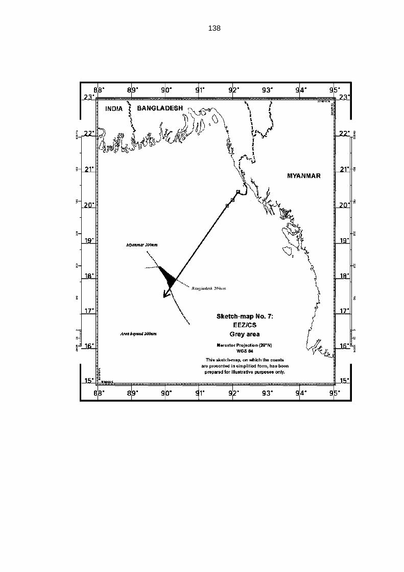
138

139
X. Disproportionality test
477. Having reached the third stage in the delimitation process as referred
to in paragraph 240, the Tribunal will, for this purpose, first determine the
relevant area, namely the area of overlapping entitlements of the Parties that
is relevant to this delimitation. The Tribunal notes in this regard that
mathematical precision is not required in the calculation of either the relevant
coasts or the relevant area.
478. Bangladesh maintains that the relevant area includes the maritime
space “situated in the coastal fronts [of the two Parties] and extending out to
the 200 [nm]”.
479. Bangladesh recalls that its model of the relevant area does not include
maritime spaces landward of the Parties’ coastal façades but notes that even
if those areas were included they would not make a material difference to the
proportionality calculation.
480. In determining the relevant area, Bangladesh excludes the areas
claimed by third States. According to Bangladesh, “[i]t cannot be right to credit
Bangladesh for maritime spaces that are subject to an active claim by a third
State”. Bangladesh cautions that “[t]o include those areas in the
proportionality calculations would have a dramatic effect on the numbers that
distorts reality”. Bangladesh therefore submits that areas on the “Indian side”
of India’s claim are not relevant in the present case.
481. Bangladesh submits that “it is not appropriate to treat as relevant the
maritime areas lying off Myanmar’s coast between Bhiff Cape and Cape
Negrais. […] It would be incongruous to consider as relevant the maritime
spaces adjacent to an irrelevant coast”.
482. According to Bangladesh, the relevant area measures
175,326.8 square kilometres. On the basis of a different calculation of the

140
length of the coasts, Bangladesh also indicated the figure of 252,500 square
kilometres.
483. Myanmar asserts that the relevant maritime area is dependent on the
relevant coasts and the projections of these coasts, insofar as they overlap. It
describes the relevant area as follows:
(i) to the north and to the east, it includes all maritime projections from Bangladesh’s relevant coasts, except the area where Bangladesh coasts face each other (the triangle between the second and the third segments); (ii) to the east and to the south, it includes all maritime projections from Myanmar’s Rakhine (Arakan) coast, as far as these projections overlap with Bangladesh’s; (iii) to the west, it extends these maritime projections up to the point they overlap.
484. Myanmar submits that Bangladesh has incorrectly portrayed the
relevant area. It asserts that in fact “the relevant area consists of the maritime
area generated by the projections of Bangladesh’s relevant coasts and
Myanmar’s relevant coast”.
485. Myanmar states that there are two issues in relation to which the
Parties are not in agreement. One of these issues concerns the exact extent
of the relevant area on the Indian side of India’s claim. The other issue
concerns the relevance of the southern part of the coast of Rakhine.
486. Myanmar disagrees with Bangladesh’s contention that the areas on the
Indian side of India’s claim are not relevant in the present case. According to
Myanmar, Bangladesh, in not including these areas, not only excluded a
maritime area of more than 11,000 square kilometres, but also made the
delimitation between Bangladesh and Myanmar dependent on the claims of a
third State, claims that are – according to Bangladesh – changing and in no
way established in law or in fact. For this reason, Myanmar is of the view that
these areas should be included in the relevant area up to the equidistance line
between the coasts of Bangladesh and India.
141
487. Concerning the southern part of the coast of Rakhine, Myanmar argues
that Bangladesh also fails to take into account the south coast of Myanmar
which extending all the way to Cape Negrais. Myanmar submits that “this part
of the coast is relevant. Its projection overlaps with the projection of the coast
of Bangladesh”.
488. Myanmar submits that the relevant area has a “total surface of
236,539 square kilometres”. During the hearing, however, Myanmar referred
to the figure of approximately 214,300 square kilometres.
* * *
489. The Tribunal notes that the relevant maritime area for the purpose of
the delimitation of the exclusive economic zone and the continental shelf
between Bangladesh and Myanmar is that resulting from the projections of the
relevant coasts of the Parties.
490. The Tribunal recalls that the Parties disagree on two points insofar as
the determination of the relevant maritime area is concerned. First, the Parties
disagree as to the inclusion of the southerly maritime area related to the
southern part of the coast of Rakhine which extends to Cape Negrais and,
second, they also disagree on the exact extent of the relevant area in the
north-west section.
491. Regarding the first issue, the Tribunal recalls that it has already found
that the segment of Myanmar’s coast that runs from Bhiff Cape to Cape
Negrais is to be included in the calculation of the relevant coast. Therefore,
the southern maritime area extending to Cape Negrais must be included in
the calculation of the relevant area for the purpose of the test of
disproportionality. The southern limit of the relevant area will be marked by
the parallel westward from Cape Negrais.
142
492. Turning to the north-west section of the maritime area which falls within
the overlapping area, the Tribunal finds that it should be included in the
relevant area for the purpose of the test of disproportionality.
493. In this regard, the Tribunal considers that, for the purpose of
determining any disproportionality in respect of areas allocated to the Parties,
the relevant area should include maritime areas subject to overlapping
entitlements of the Parties to the present case.
494. The fact that a third party may claim the same maritime area does not
prevent its inclusion in the relevant maritime area for purposes of the
disproportionality test. This in no way affects the rights of third parties.
495. For the purposes of the determination of the relevant area, the Tribunal
decides that the western limit of the relevant area is marked by a straight line
drawn from point ß2 due south.
496. Accordingly, the size of the relevant area has been calculated to be
approximately 283,471 square kilometres.
497. The Tribunal will now check whether the adjusted equidistance line has
caused a significant disproportion by reference to the ratio of the length of the
coastlines of the Parties and the ratio of the relevant maritime area allocated
to each Party.
498. The length of the relevant coast of Bangladesh, as indicated in
paragraph 202, is 413 kilometres, while that of Myanmar, as indicated in
paragraph 204, is 587 kilometres. The ratio of the length of the relevant
coasts of the Parties is 1:1.42 in favour of Myanmar.
499. The Tribunal notes that its adjusted delimitation line (see
paragraphs 337-340) allocates approximately 111,631 square kilometres of
the relevant area to Bangladesh and approximately 171,832 square
kilometres to Myanmar. The ratio of the allocated areas is approximately

143
1:1.54 in favour of Myanmar. The Tribunal finds that this ratio does not lead to
any significant disproportion in the allocation of maritime areas to the Parties
relative to the respective lengths of their coasts that would require the shifting
of the adjusted equidistance line in order to ensure an equitable solution.

144
145
XI. Description of the delimitation line
500. All coordinates and azimuths used by the Tribunal in this Judgment are
given by reference to WGS 84 as geodetic datum.
501. The delimitation line for the territorial sea between the two Parties is
defined by points 1, 2, 3, 4, 5, 6, 7 and 8 with the following coordinates and
connected by geodetic lines:
1: 20° 42’ 15.8’’ N, 92°22’ 07.2’’ E; 2: 20° 40’ 45.0’’ N, 92°20’ 29.0’’ E; 3: 20° 39’ 51.0” N, 92° 21’ 11.5” E; 4: 20° 37’ 13.5” N, 92° 23’ 42.3” E; 5: 20° 35’ 26.7” N, 92° 24’ 58.5” E; 6: 20° 33’ 17.8” N, 92° 25’ 46.0” E; 7: 20° 26’ 11.3” N, 92° 24’ 52.4” E; 8: 20° 22’ 46.1” N, 92° 24’ 09.1” E.
502. From point 8 the single maritime boundary follows in a northwesterly
direction the 12 nm envelope of arcs of the territorial sea around St Martin’s
Island until it intersects at point 9 (with coordinates 20° 26’ 39.2” N,
92° 9’ 50.7” E) with the delimitation line of the exclusive economic zone and
the continental shelf between the Parties.
503. From point 9, the single maritime boundary follows a geodetic line until
point 10 with coordinates 20° 13’ 06.3” N, 92° 00’ 07.6” E.
504. From point 10, the single maritime boundary follows a geodetic line
until point 11 with coordinates 20° 03’ 32.0” N, 91° 50’ 31.8” E.
505. From point 11, the single maritime boundary continues as a geodetic
line starting at an azimuth of 215° until it reaches the area where the rights of
third States may be affected.

146
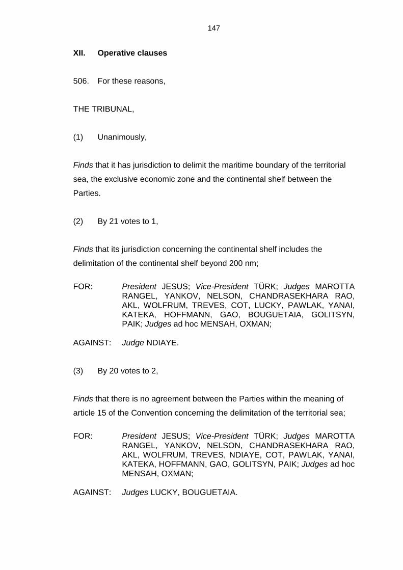
147
XII. Operative clauses
506. For these reasons,
THE TRIBUNAL,
(1) Unanimously,
Finds that it has jurisdiction to delimit the maritime boundary of the territorial
sea, the exclusive economic zone and the continental shelf between the
Parties.
(2) By 21 votes to 1,
Finds that its jurisdiction concerning the continental shelf includes the
delimitation of the continental shelf beyond 200 nm;
FOR: President JESUS; Vice-President TÜRK; Judges MAROTTA
RANGEL, YANKOV, NELSON, CHANDRASEKHARA RAO, AKL, WOLFRUM, TREVES, COT, LUCKY, PAWLAK, YANAI, KATEKA, HOFFMANN, GAO, BOUGUETAIA, GOLITSYN, PAIK; Judges ad hoc MENSAH, OXMAN;
AGAINST: Judge NDIAYE.
(3) By 20 votes to 2,
Finds that there is no agreement between the Parties within the meaning of
article 15 of the Convention concerning the delimitation of the territorial sea;
FOR: President JESUS; Vice-President TÜRK; Judges MAROTTA
RANGEL, YANKOV, NELSON, CHANDRASEKHARA RAO, AKL, WOLFRUM, TREVES, NDIAYE, COT, PAWLAK, YANAI, KATEKA, HOFFMANN, GAO, GOLITSYN, PAIK; Judges ad hoc MENSAH, OXMAN;
AGAINST: Judges LUCKY, BOUGUETAIA.
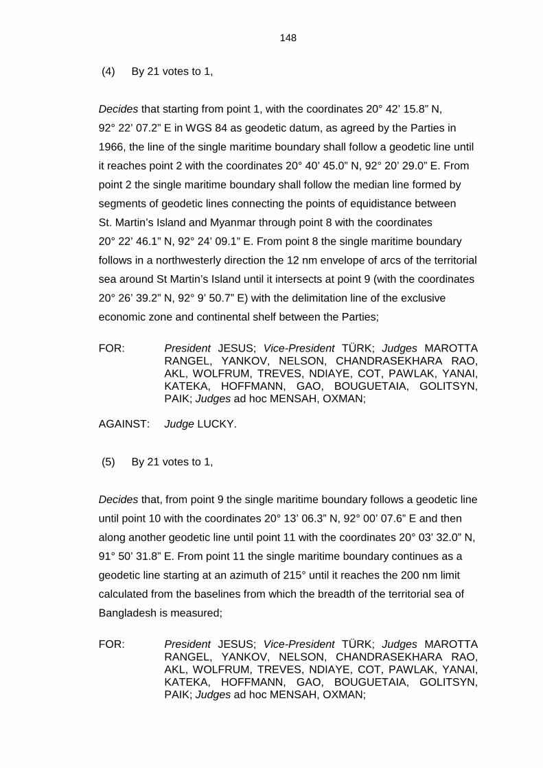
148
(4) By 21 votes to 1,
Decides that starting from point 1, with the coordinates 20° 42’ 15.8” N,
92° 22’ 07.2” E in WGS 84 as geodetic datum, as agreed by the Parties in
1966, the line of the single maritime boundary shall follow a geodetic line until
it reaches point 2 with the coordinates 20° 40’ 45.0” N, 92° 20’ 29.0” E. From
point 2 the single maritime boundary shall follow the median line formed by
segments of geodetic lines connecting the points of equidistance between
St. Martin’s Island and Myanmar through point 8 with the coordinates
20° 22’ 46.1” N, 92° 24’ 09.1” E. From point 8 the single maritime boundary
follows in a northwesterly direction the 12 nm envelope of arcs of the territorial
sea around St Martin’s Island until it intersects at point 9 (with the coordinates
20° 26’ 39.2” N, 92° 9’ 50.7” E) with the delimitation line of the exclusive
economic zone and continental shelf between the Parties;
FOR: President JESUS; Vice-President TÜRK; Judges MAROTTA
RANGEL, YANKOV, NELSON, CHANDRASEKHARA RAO, AKL, WOLFRUM, TREVES, NDIAYE, COT, PAWLAK, YANAI, KATEKA, HOFFMANN, GAO, BOUGUETAIA, GOLITSYN, PAIK; Judges ad hoc MENSAH, OXMAN;
AGAINST: Judge LUCKY.
(5) By 21 votes to 1,
Decides that, from point 9 the single maritime boundary follows a geodetic line
until point 10 with the coordinates 20° 13’ 06.3” N, 92° 00’ 07.6” E and then
along another geodetic line until point 11 with the coordinates 20° 03’ 32.0” N,
91° 50’ 31.8” E. From point 11 the single maritime boundary continues as a
geodetic line starting at an azimuth of 215° until it reaches the 200 nm limit
calculated from the baselines from which the breadth of the territorial sea of
Bangladesh is measured;
FOR: President JESUS; Vice-President TÜRK; Judges MAROTTA
RANGEL, YANKOV, NELSON, CHANDRASEKHARA RAO, AKL, WOLFRUM, TREVES, NDIAYE, COT, PAWLAK, YANAI, KATEKA, HOFFMANN, GAO, BOUGUETAIA, GOLITSYN, PAIK; Judges ad hoc MENSAH, OXMAN;

149
AGAINST: Judge LUCKY.
(6) By 19 votes to 3,
Decides that, beyond that 200 nm limit, the maritime boundary shall continue,
along the geodetic line starting from point 11 at an azimuth of 215° as
identified in operative paragraph 5, until it reaches the area where the rights of
third States may be affected.
FOR: President JESUS; Vice-President TÜRK; Judges MAROTTA RANGEL, YANKOV, NELSON, CHANDRASEKHARA RAO, AKL, WOLFRUM, TREVES, COT, PAWLAK, YANAI, KATEKA, HOFFMANN, BOUGUETAIA, GOLITSYN, PAIK; Judges ad hoc MENSAH, OXMAN;
AGAINST: Judges NDIAYE, LUCKY, GAO.
Done in English and in French, both texts being equally authoritative, in
the Free and Hanseatic City of Hamburg, this fourteenth day of March, two
thousand and twelve, in three copies, one of which will be placed in the
archives of the Tribunal and the others transmitted to the Government of the
People’s Republic of Bangladesh and the Government of the Republic of the
Union of Myanmar, respectively.
(signed)
JOSE LUIS JESUS,
President
(signed)
PHILIPPE GAUTIER,
Registrar

150
Judges NELSON, CHANDRASEKHARA RAO and COT, availing themselves of the right conferred on them by article 125, paragraph 2, of the Rules of the Tribunal, append their joint declaration to the Judgment of the Tribunal.
(initialled) L.D.M.N. (initialled) P.C.R. (initialled) J.-P.C.
Judge WOLFRUM, availing himself of the right conferred on him by article 125, paragraph 2, of the Rules of the Tribunal, appends his declaration to the Judgment of the Tribunal.
(initialled) R.W.
Judge TREVES, availing himself of the right conferred on him by article 125, paragraph 2, of the Rules of the Tribunal, appends his declaration to the Judgment of the Tribunal.
(initialled) T.T.
Judges ad hoc MENSAH and OXMAN, availing themselves of the right conferred on them by article 125, paragraph 2, of the Rules of the Tribunal, append their joint declaration to the Judgment of the Tribunal.
(initialled) T.A.M. (initialled) B.H.O.
Judge NDIAYE, availing himself of the right conferred on him by article 30, paragraph 3, of the Statute of the Tribunal, appends his separate opinion to the Judgment of the Tribunal.
(initialled) T.M.N.
Judge COT, availing himself of the right conferred on him by article 30, paragraph 3, of the Statute of the Tribunal, appends his separate opinion to the Judgment of the Tribunal.
(initialled) J.-P.C.

151
Judge GAO, availing himself of the right conferred on him by article 30, paragraph 3, of the Statute of the Tribunal, appends his separate opinion to the Judgment of the Tribunal.
(initialled) Z.G.
Judge LUCKY, availing himself of the right conferred on him by article 30, paragraph 3, of the Statute of the Tribunal, appends his dissenting opinion to the Judgment of the Tribunal.
(initialled) A.A.L.

JOINT DECLARATION OF JUDGES NELSON, CHANDRASEKHARA RAO AND COT
The law of maritime delimitation of the EEZ and continental shelf has
considerably developed over the past 25 years, thanks to the contribution of
international courts and tribunals through their jurisprudence. The provisions
of the Convention, articles 74 and 83, are imprecise to say the least. Courts
and tribunals have progressively reduced the elements of subjectivity in the
process of delimitation in order to further the reliability and predictability of
decisions in this matter.
We consider that the International Tribunal for the Law of the Sea
should welcome these developments and squarely embrace the methodology
of maritime delimitation as it stands today, thus adding its contribution to the
consolidation of the case law in this field.
It is not enough to pay lip service to these developments. The Tribunal
must firmly uphold the three step approach as it has been formulated over the
years.
The choice of a method of delimitation in a particular case must be
considered in a strictly objective perspective and based on geographical
considerations, in particular the general configuration of the coastline.
Priority is given today to the equidistance/relevant circumstances
method. Resort to equidistance as a first step leads to a delimitation that is
simple and precise. However complicated the coastline involved is, there is
always one and only one equidistance line, whose construction results from
geometry and can be produced through graphic and analytical methods. A
provisional equidistance line is to be drawn, calculated by reference to
adequate base points chosen along the continental coasts of both parties. As
the International Court of Justice stated authoritatively in the Maritime
Delimitation in the Black Sea (Romania v. Ukraine) Judgment, it is only if
there are compelling reasons that make this unfeasible on objective
2
geographical or geophysical grounds, such as the instability of the coastline,
that one should contemplate another method of delimitation, for instance the
angle bisector method.
Considerations of equity come to play only in the second phase of the
delimitation, as they necessarily carry an important element of subjectivity.
Relevant circumstances may call for an adjustment of the provisional
equidistance line so as to ensure an equitable solution. Among the relevant
circumstances considered by the case law is the concavity of the coastline
with its eventual cut-off effect, of particular importance in the present case.
Other relevant circumstances include the relative length of coasts, the
presence of islands, considerations relating to economic resources, fisheries,
security concerns and navigation.
The test of disproportionality in the third phase ensures that an
equitable solution is the result of the delimitation process.
Application of these principles calls for consistency. One should not try
to reintroduce other methods of delimitation when implementing the
equidistance/relevant circumstances rule. It would amount to reintroducing the
very elements of subjectivity progressively reduced over the years.
By reaffirming and respecting these basic principles, the Tribunal will
hopefully bring a significant and positive contribution to the development of
the law of maritime delimitation in the years to come.
(signed)
L. Dolliver M. Nelson
(signed)
P. Chandrasekhara Rao
(signed)
Jean-Pierre Cot

DECLARATION OF JUDGE WOLFRUM
Although I voted in favour of the judgment I consider it necessary to
add some comments to supplement, to interpret or to emphasize parts of its
reasoning. I shall do so in respect of the methodology used in delimiting the
continental shelf and the exclusive economic zone of the Parties and the
treatment of islands in the delimitation process. Before that, however, I will
discuss the relevance the Judgment attributes to the existing case law of
international courts and tribunals in the delimitation of maritime areas.
In respect of the relevance of case law the Tribunal notes in
paragraph 184 “[d]ecisions of international courts and tribunals referred to in
Article 38 of the Statute of the ICJ, are also of importance in determining the
content of the law applicable to maritime delimitation under article 74 and 83
of the Convention.” In the same paragraph the Tribunal concurs with a
statement of the Arbitral Award of 11 April 2006: “In a matter that has so
significantly evolved over the last 60 years, customary law also has a
particular role that, together with judicial and arbitral decisions, helps to shape
the considerations that apply to any process of delimitation.”
These statements, the statement of the Tribunal and the one of the
Arbitral Tribunal, are neither identical nor very clear in their meaning. Taken
literally they attribute a different role to case law. Whereas according to the
Tribunal case law seems to be a means of identifying the applicable law the
Arbitral Tribunal seems to consider case law to be an independent source of
international law.
According to Article 38 of the Statute of the ICJ, decisions of
international courts are means for identifying the applicable sources of
international law. It is doubtful whether this adequately describes the role that
international case law plays and is meant to play in the delimitation of the
continental shelf and the exclusive economic zone.
2
Case law of international courts and tribunals is more than a means to
identify the customary or treaty law relevant for the delimitation of continental
shelves and exclusive economic zones as stated by the Tribunal. In my view
international courts and tribunals in respect of maritime delimitation exercise a
“law-making function”, a function which is anticipated and legitimized by
articles 74 and 83 of the Convention. In this context it is appropriate to
mention that article 287 of the Convention entrusts three institutions with the
task and responsibility of interpreting and, within the framework of the
Convention, to progressively develop it. This requires them to harmonize their
jurisprudence with the view avoiding any fragmentation, in particular in
respect of delimitation of maritime areas.
Unlike for the delimitation of the territorial sea, the Third UN
Conference on the Law of the Sea could not agree on a particular method of
delimitation of the continental shelf and the exclusive economic zone. The
Conference therefore left the task of the delimitation to the coastal States
concerned and – if they could not agree – to judicial dispute settlement. That
means it is the task, and even the responsibility of international courts and
tribunals (when requested to settle disputes) to develop the methodology that
is suitable for this purpose. In doing so they are guided by a paramount
objective, namely, that the method chosen can lead to an equitable result and
that, at the end of the process, an equitable result is achieved. This is stated
in the Judgment (paragraph 235). Further objectives to be taken into
consideration by international courts and tribunals are to provide for
transparency and predictability of the whole process. The ensuing
international case law constitutes an acquis judiciare, a source of international
law to be read into articles 74 and 83 of the Convention. It is the feature of this
law not to be static but to be open for a progressive development by the
international courts and tribunals concerned. It is the responsibility of these
international courts and tribunals not only to decide delimitation cases while
remaining within the framework of such acquis judiciare but also to provide for
the progressive development of the latter. They are called upon in further
developing this acquis judiciare to take into account new scientific findings.

3
As far as the progressive development of the acquis judiciaire on
maritime delimitation is concerned, I am of the view that the Tribunal could
and should have been more forth-coming.
The Tribunal was faced amongst others with the problem of islands in
the delimitation process. It stated that the effect to be given ‘depends on the
geographic circumstances of the case’ and that there is no general rule in this
respect. Each case was unique and called for specific treatment the ultimate
goal being to reach a solution which was equitable (paragraph 317). Such a
statement does not provide any meaningful guidance. That the geographical
features have to be taken into account is self-evident and equally that the
result achieved has to equitable. But what is equitable in a situation as the
one concerning St. Martin’s Island? The Tribunal should have spelled out
which considerations it took into account and which it did not. If it had done so
it would have provided for the development of the general rule which is
missing.
The Tribunal concludes that – where the territorial waters of St. Martin’s
Islands do not overlap with the territorial waters of the mainland coast of
Myanmar – St. Martin’s Island should have a right to a territorial sea of 12 nm.
I fully share this finding, in particular the reasoning that deciding otherwise
more weight would have been given to the sovereign rights of Myanmar in its
exclusive economic zone and continental shelf than to the sovereignty of
Bangladesh over its territorial sea (paragraph 169). It is evident that this
statement of principle only refers to the case before the Tribunal. It is to be
regretted that the Tribunal does not formulate the principle as a general one
indicating whether there might exist exceptions.
In respect of the delimitation of the continental shelf and the exclusive
economic zone St. Martin’s Island was not given any relevance. The Tribunal
even ruled out that a base point on St. Martin’s Island should be established
for the delimitation of the exclusive economic zone or the continental shelf.
Although I share this decision it would have required a more detailed and in-
depth reasoning. In particular, since such decision is not easy to understand
4
after St. Martin’s Island was given its full effect in the delineation of the
territorial sea.
Regarding the exclusive economic zone and the continental shelf the
Tribunal mostly justified its decision by relying on the ICJ judgment in the
Black Sea case (Maritime Delimitation in the Black Sea (Romania v. Ukraine),
Judgment, I.C.J. Reports 2009, p. 61, at paragraph 149). In this regard the
Tribunal states that giving effect to St. Martin’s Island would result in a line
blocking the seaward projection from Myanmar’s coast that would cause an
unwarranted distortion of the delimitation line (paragraph 265). This argument,
as formulated, seems to be a subjective one. No objective grounds are
provided why the so-called distortion is unwarranted. This does not meet the
standards referred to above namely transparency and predictability. In my
view the Tribunal should have further discussed whether in a situation such as
this one the feature governing delimitation was the mainland or the island;
whether the proportion of the size of the island in comparison to the size of
the maritime area in question was of relevance; and whether and to what
extent the freedom of access to the sea should also be a determining factor.
Equally, there is no substantial reasoning as to why no base points
were identified on St. Martin’s Islands. Here again, the Tribunal followed the
reasoning ICJ in the Black Sea case (at p. 110) dealing with Serpents’ Island
which I equally find unconvincing. Moreover I note that the Tribunal’s decision
on St. Martin’s Island has not prevented it to select an additional base-point
on the southern tip of the Myanmar island Myay Ngu Kyun (paragraph 266)
without answering the question why such base-point could govern justifiably
the direction of the delimitation line, more than 180 nm off the coast of
Myanmar.
To sum up, I think the Tribunal missed the opportunity to progressively
develop the rules on islands in the delimitation process and thus to contribute
to the acquis judiciare on the rules concerning maritime delimitation. In my
view, such contribution would have been particularly called for since

5
international jurisprudence, so far, seems to lack the necessary coherence on
this issue.
As far as the delimitation of the exclusive economic zone and the
continental shelf is concerned, the Tribunal follows the three step approach as
developed by the ICJ in the Black Sea case. Considering the subsection on
the disproportionality test, one wonders whether it is really enlightening. It
would have been equally appropriate just to employ a two step procedure.
Consideration on proportionality should then be integrated into the
considerations leading to the adjustment of the provisional equidistance line.
Considerations on proportionality should cover a broader spectrum than they
do now and their separation from the reasoning leading to the adjustment of
the equidistance line seems to be artificial. Both steps, the second and the
third step, may result in an adjustment of the equidistance line and thus
should be combined.
The Tribunal has constructed its provisional equidistance line lege artis.
Equally the statement that ‘the objective is a line that allows the relevant
coasts of the Parties’ to produce their effects, in terms of maritime
entitlements, is reasonable and mutually balanced way is to be endorsed.
However, there is very little reasoning explaining why the adjusted line must
be deflected at point B1 and none at all why the line should follow an azimuth
of 215°. It is to be noted that the azimuth of 215° was the line constructed by
Bangladesh on the basis of its angle bi-sector method, a method rejected by
the Tribunal (paragraph 234-237).
I have no reason to doubt that this line constitutes an equitable result,
as required by article 74 and 83 of the Convention, but other lines may equally
have done so. However, the way in which the Tribunal reaches this
conclusion again lacks transparency. The Tribunal tries to justify its reluctance
to consider alternatives to this line by repeating a statement of the Arbitral
Tribunal in the Barbados Trinidad and Tobago case (paragraph 337) that
there is no ‘magic formula’ for the adjustment (paragraph 327). Although there
may be no formula covering all geographical circumstances there would have

6
been definitely some merit in looking into alternatives. A discussion of
alternatives already tested in the jurisprudence of international courts and
tribunals, such as changing the position of the line but not its direction or
changing both, was called for. Some of these alternatives would have had the
advantage that the adjusted line would not have started northwest of
St. Martin’s Island and thus would not have enclosed it so much. But even if
the Tribunal had come to the same conclusion, an in depth consideration of
the starting point of the adjusted delimitation line, and its direction, would have
clearly enforced the findings of the judgment and at the same time made the
required contribution to the acquis judiciare on the delimitation of the
continental shelf and the exclusive economic zone.
Finally, it is to be emphasized that the Tribunal breaks new ground on
the delimitation of the continental shelf beyond 200 nm, an issue that mostly
has been avoided by international courts and tribunals, so far. I consider that
this part of the judgment positively contributes to the international case law on
maritime delimitation although some additional reasoning might have
enhanced its being fully accepted by other international courts and tribunals.
(signed)
Rüdiger Wolfrum

DECLARATION OF JUDGE TREVES
1. I agree with the conclusions reached in the Judgment and with the
reasons given. I would like, however, to make a brief general observation and
offer some slightly more detailed considerations on jurisdiction.
2. This is the first time the Tribunal has decided a delimitation dispute on
the merits. Delimitation of maritime areas is the law of the sea subject that
most frequently has occupied international courts and tribunals. Under the
Convention delimitation disputes fall within the scope of compulsory
jurisdiction, save where States parties have made the optional declaration
under article 298, paragraph 1. The Convention is indifferent as regards which
adjudicating body exercises compulsory jurisdiction. Under article 287 such
body may the Tribunal, the International Court of Justice or an arbitration
tribunal constituted in accordance with annexes VII or VIII. Moreover, under
article 282 procedures set out in general, regional or bilateral agreements
providing that the dispute shall be submitted, at the request of a party, to a
procedure that entails a binding decision are considered applicable in lieu of
those set out in Part XV. To these various possible fora must be added the
courts and tribunals to which the parties may submit their dispute by
agreement. Consequently, a variety of international courts and tribunals may
be called upon to adjudicate delimitation disputes on the basis of the
jurisdictional and substantive provisions of the Convention. The framers of the
Convention would seem not to have been concerned about the danger of
fragmentation that decisions on the same body of law by different courts and
tribunals might entail, a danger that some, but certainly not all, scholars and
practitioners consider grave. In order to avert such danger and to prove that
the possibility of decisions by different courts and tribunals on the same law
may be a source of richness and not of contradiction, all courts and tribunals
called to decide on the interpretation and application of the Convention,
including its provisions on delimitation, should, in my view, consider
themselves as parts of a collective interpretative endeavour, in which, while
keeping in mind the need to ensure consistency and coherence, each

2
contributes its grain of wisdom and its particular outlook. The coexistence of a
jurisprudence on delimitation of the International Court of Justice with awards
of arbitration tribunals augurs well. Arbitration tribunals have participated, in
an harmonious manner, in the development of the jurisprudence emerging
from the judgments of the International Court of Justice. With the present
judgment the Tribunal becomes an active participant in this collective
interpretative endeavour. While it has adopted the methodology developed by
the International Court of Justice and recent arbitral awards, the Tribunal has
also contributed its own grain of wisdom and particular outlook. This
contribution consists, in my view, especially in the manner in which the
Tribunal has applied the notion of relevant circumstances and in its decision
to delimit the continental shelf beyond 200 miles.
3. Coming now to my more specific observations, I shall begin by noting
that the statements concerning jurisdiction set out in the judgment do not
express clearly the view of the Tribunal in respect of the basis of its
jurisdiction. Admittedly, it was not strictly necessary to be specific as there
was no doubt that such jurisdiction existed. In my view it would, nonetheless,
have been opportune to take a position in light of the persistent uncertainty of
the jurisprudence of the Tribunal when confronted with the question of
establishing its jurisdiction in cases in which an agreement of the parties was
reached after submission to adjudication had been effected under the
compulsory jurisdiction provisions of articles 286 and 287 of the Convention.
4. Submission to adjudication of the dispute concerning the delimitation of
the maritime boundaries between Bangladesh and Myanmar was initiated by
Bangladesh on 8 October 2009 when it instituted arbitral proceedings against
Myanmar in reliance on the compulsory jurisdiction provisions of the
Convention and the fact that, at that time, neither party had made a
declaration choosing a procedure for the exercise of compulsory jurisdiction
under article 287 of the Convention. On 4 November 2009 Myanmar made a
declaration “in accordance with article 287, paragraph 1,” of the Convention,
accepting the jurisdiction of the Tribunal for the settlement of the dispute with
Bangladesh relating to the delimitation of the maritime boundary between the

3
two countries. On 12 December 2009 Bangladesh made an almost identical
declaration. On 13 December 2009 Bangladesh stated in a letter from its
Minister of Foreign Affairs to the Tribunal that: “Given Bangladesh’s and
Myanmar’s mutual consent to the jurisdiction of ITLOS and in accordance with
the provisions of UNCLOS Article 287(4), Bangladesh considers that your
distinguished Tribunal is now the only forum for the resolution of the parties’
dispute”. The reference to the “mutual consent” of the Parties gives the
impression that agreement and not compulsory jurisdiction is seen as the
basis of jurisdiction, while the reference to article 287, paragraph 4, gives the
opposite impression. Myanmar in its Counter-Memorial (paragraph 1.7) opts
clearly for the view that the jurisdiction of the Tribunal is based “on a special
agreement between Myanmar and Bangladesh under article 55 of the Rules
of the Tribunal, which agreement is reflected in their respective declarations
dated 4 November 2009 and 12 December 2009”.
5. The Tribunal leaves the question open. It reports having entered the
case in the List of cases “[i]n view of the above-mentioned declarations, and
the letter of the Minister of Foreign Affairs of Bangladesh dated 13 December
2009” (paragraph 5). In deciding on its jurisdiction, it refers to the acceptance
of such jurisdiction by the declarations of the Parties under article 287,
paragraph 1, of the Convention (paragraph 47) and to the fact that that “the
Parties agree that the Tribunal has jurisdiction to adjudicate the dispute”
(paragraph 49).
6. A certain degree of uncertainty as regards the view of the Tribunal as
to the basis of its jurisdiction also emerges in earlier cases which were
initiated by unilateral submission to an arbitral tribunal.
7. The M/V “SAIGA” Case was submitted by Saint Vincent and the
Grenadines to an annex VII arbitral tribunal, and later transferred to the
Tribunal by an agreement concluded in 1998 with Guinea, the other party to

4
the case1
. The Tribunal found that “the basis of its jurisdiction is the 1998
Agreement, which transferred the dispute to the Tribunal, together with
articles 286, 287 and 288 of the Convention” (paragraph 43 of the Judgment).
Was the basis of jurisdiction to be found in the compulsory jurisdiction
articles 286, 287 and 288 to which the unilateral notification of Saint Vincent
and the Grenadines for the establishment of an arbitral tribunal referred, or in
the 1998 Agreement? In examining whether Guinea could raise objections to
admissibility, the Tribunal seems to have opted for an interpretation of the
1988 Agreement ruling out the agreement as the basis of its jurisdiction. It
stated that, in its view: “the object and purpose of the 1998 Agreement was to
transfer to the Tribunal the same dispute that would have been the subject of
the proceedings before the arbitral tribunal. Before the arbitral tribunal each
party would have retained the general right to present its contentions. The
Tribunal considers that the parties have the same rights in the present
proceedings”. Consequently, it concluded “that the 1998 Agreement does not
preclude the raising of objections of admissibility by Guinea” (paragraph 51 of
the Judgment).
8. In the Swordfish case2
1 M/V “Saiga” (No. 2) Case (Saint Vincent and the Grenadines v. Guinea), Provisional Measures, Order of 11 March 1998, ITLOS Reports 1998, p. 14, and Judgment of 1 July 1999, ITLOS Reports 1999, p. 10.
Chile initiated proceedings against the
European Community (later European Union) by instituting arbitral
proceedings under article 287, paragraph 3, of the Convention. Through an
exchange of letters dated 18 and 19 December 2000, the parties agreed that
the dispute “be not proceeded” in accordance with the arbitral procedure and
that it would be submitted to a special chamber of the Tribunal. The
agreement provided that the Chamber should decide on a list of issues “to the
extent that they are subject to compulsory procedures entailing binding
decisions under Part XV of the Convention”. The agreement is similar to a
compromis in that t submitted to the Special Chamber a list of issues to be
decided (not all of which were identical with those Chile had submitted to the
arbitral tribunal) and in that it specifies that the case “shall be deemed to have
2 Conservation and Sustainable Exploitation of Swordfish Stocks (Chile/European Community), Order of 20 December 2000, ITLOS Reports 2000, p. 148.
5
been instituted ... on the date on which the parties have notified the Tribunal
of their request to submit” their dispute to a special chamber of the Tribunal.
However, in stating that the jurisdiction of the chamber would not extend to
matters which it would not have been possible to submit to the arbitral tribunal
under article 287, it retains the fundamental characteristic of cases submitted
to adjudication on the basis of the compulsory jurisdiction provisions of the
Convention.
9. Further, a pending case, that of the M/V “Virginia G” between Panama
and Guinea Bissau, was initiated by the institution of arbitral proceedings
under article 287 and transferred by agreement to the Tribunal. The parties
agreed that the proposal of Panama to transfer the case to the Tribunal and
its acceptance by Guinea Bissau were sufficient to constitute a special
agreement to submit the case to the Tribunal under article 55 of the Rules of
the Tribunal (which deals with submission of a dispute to the Tribunal by
notification of a special agreement).
10. Seen together with the other three cases mentioned, the present case
shows that the compulsory jurisdiction provisions of the Convention are often
necessary for a dispute concerning the interpretation or application of the
Convention to be submitted to adjudication. These cases also show, however,
that after unilateral submission to adjudication, and in light of the fact that
there is no way to avoid adjudication, the common will of the parties may
intervene in various ways to replace the adjudicating body initially called to
exercise jurisdiction with another. The cases examined show that this may be
done by agreements to transfer the case from one adjudicating body to
another or to cancel the previously commenced proceedings and to institute
new proceedings. Interpretation questions may remain open as to whether the
agreements concluded for transferring jurisdiction from one adjudicating body
to another amount to a new submission by special agreement or to a simple
transfer of the case to the other adjudicating body without any change.
11. In the present case the Parties have used the declarations under
article 287, paragraph 1, as a means to reach an agreement to establish the
6
jurisdiction of the Tribunal, replacing the jurisdiction of the arbitral tribunal
established unilaterally by Bangladesh. Their declarations under article 287
accept the jurisdiction of the Tribunal not in general terms, as the drafters of
the Convention presumably intended in light of the general language they
used, but with respect to a single specific dispute3
. The interpretative question
that arises, and that the Tribunal has chosen not to address, is whether in so
doing they concluded a special agreement (as Myanmar indicates in its
Counter-Memorial quoted above) or whether the references to article 287
require that jurisdiction be considered as established unilaterally by
Bangladesh’s letter of 13 December 2009.
12. No issue has arisen in the present case that would make the
determination of the basis of jurisdiction relevant for deciding a question
submitted to the Tribunal. The remarks in the M/V “SAIGA” Judgment quoted
in paragraph 7 above indicate, however, that such a determination may be
important in certain cases, the most relevant of which seems to concern the
applicability to the dispute of the limitations and exceptions to jurisdiction set
out in articles 297 and 298 of the Convention. These limitations and
exceptions undoubtedly apply to disputes submitted to adjudication under
section 2 of Part XV of the Convention (namely, on the basis of the
compulsory jurisdiction of the courts and tribunals mentioned therein) as they
are included in section 3, entitled “Limitations and exceptions to applicability
of section 2”. They do not, however, apply to cases submitted by the
agreement of the parties on the basis of section 1. This difference alone
seems to warrant close attention by the Tribunal in future cases.
(signed)
Tullio Treves
3 It is worth noting that in the M/V “Louisa” Case the Tribunal has recently had to consider a declaration made under article 287 limited to a very narrow category of disputes. The declaration by Saint Vincent and the Grenadines considered in that case chooses the Tribunal “as the means for the settlement of disputes concerning the arrest or detention of vessels”: M/V “Louisa” (Saint Vincent and the Grenadines v. Kingdom of Spain), Provisional Measures, Order of 23 December 2010, ITLOS Reports 2008-2010, p. 58.
JOINT DECLARATION OF JUDGES AD HOC MENSAH AND OXMAN
1. We support the Judgment of the Tribunal. We wish to add some brief
observations on a number of issues addressed therein.
Navigation and right of access
2. An important objective of maritime delimitation is to promote stability in
the relations between neighbouring States regarding activities in their waters.
This objective is also furthered by accommodating specific concerns
regarding navigation and access rights. We consider that the statement of
Bangladesh in response to the Tribunal’s question is very helpful in this
regard, and we support the decision of the Tribunal to take note of the
commitment by Bangladesh. With regard to the references to the agreement
reached in 1974 in the statements set forth in paragraphs 173 and 174 of the
Judgment, we observe that although the Tribunal’s delimitation of the
territorial sea is not founded on the existence of an agreement between the
Parties as argued by Bangladesh, the maritime boundary established by the
Tribunal in the territorial sea is based on the equidistance line proposed by
Bangladesh in these proceedings, and is essentially the same as that
contemplated by the Agreed Minutes of 23 November 1974.
Entitlement to a continental shelf beyond 200 nautical miles
3. We agree with the Tribunal’s conclusion that there is no need in this
case for the Tribunal to decline to delimit the continental shelf beyond
200 miles until such time as the Commission on the Limits of the Continental
Shelf has made its recommendations and each Party has had the opportunity
to consider its reaction. In this connection, we note that the Tribunal’s
determination that each Party is entitled to a continental shelf beyond
200 miles, and that their entitlements overlap, does not entail an interpretation
or application of article 76 of the Convention that is incompatible with the
submission that either Party has made to the Commission regarding the outer

2
limits of its continental shelf, as described in the respective executive
summaries. Accordingly, the Judgment does not prejudice the right of each
Party under paragraph 8 of article 76 to establish final and binding outer limits
of its continental shelf on the basis of the recommendations of the
Commission through the process prescribed by the Convention. This process
is neither adjudicative nor adversarial.
Delimitation of the Exclusive Economic Zone and the Continental Shelf
4. The law applicable to delimitation of the exclusive economic zone and
the continental shelf, as articulated and applied by international courts and
tribunals, entails neither an unyielding insistence on mathematical certainty
nor an unbounded quest for an equitable solution. The equidistance/relevant
circumstances method of delimitation seeks to balance the need for objectivity
and predictability with the need for sufficient flexibility to respond to
circumstances relevant to a particular delimitation. Maintaining that balance
requires that equidistance be qualified by relevant circumstances and that the
scope of relevant circumstances be circumscribed.
5. Both Parties argued that a line that is equidistant from the nearest
points on their respective coasts would not be appropriate in the geographic
circumstances of this case. While Myanmar drew its proposed boundary on
the basis of equidistance, it demonstrated that, given the size and position of
St. Martin’s Island directly in front of Myanmar’s coast near the terminus of the
land frontier, measuring an equidistance line from base points on that island
would have a distorting effect that would block the seaward projection of
Myanmar’s coast. Bangladesh, in turn, demonstrated that, because of the
marked concavity of its coast, the equidistance line advocated by Myanmar,
and even an equidistance line measured from St. Martin’s Island, would have
the unwarranted effect of cutting off the seaward projection of the northern
coast of Bangladesh.

3
6. This does not mean that resort to the angle bisector method of
delimitation is necessary. There is no difficulty in drawing a provisional
equidistance line in this case. While the angle bisector method can be viewed
as a variant of equidistance, it lacks the precision of equidistance. As noted in
the Judgment, the angle can change significantly depending on how it is
constructed. In this regard the Tribunal observed that Bangladesh constructed
its 215° bisector with reference to Bhiff Cape, which Bangladesh contended
was the limit of Myanmar’s relevant coast. The Tribunal did not accept this
contention, and determined that Myanmar’s relevant coast extends to Cape
Negrais, which would produce a significantly different bisector.
7. In this case, the 215° azimuth, properly employed, can indeed provide
an equitable solution to the problem of the cut-off effect produced by an
equidistance line. But the reason lies not in the methodology used by
Bangladesh to generate the azimuth, but rather in its effect as an adjustment
to the provisional equidistance line.
8. It is the relevant circumstance, namely the cut-off effect, and the need
to give the coasts of both Parties their effects in a reasonable and balanced
way, that dictate both the location and the direction of an adjustment to the
provisional equidistance line. While no adjustment for relevant circumstances
is immune to the risks of subjectivity, the focus on addressing the precise
problem posed by the provisional equidistance line, and on the relationship of
any adjustment to the relevant coasts of both Parties as they are, helps to
discipline the process and to direct attention to the right questions.
9. Neither Party expressly addressed the issue of how an adjustment to
the equidistance line should be made that would give appropriate effect to the
seaward projection of the northern coast of Bangladesh. However,
independently of its boundary proposal of a transposed angle bisector,
Bangladesh also adverted to the 215° azimuth to illustrate inequities in
various hypothetical lines. The Parties had the opportunity, albeit in a different
context, to comment on the advantages and disadvantages of using that
4
azimuth, and each of them availed itself of that opportunity at length in its
written and oral pleadings. While we do not think that this fact in and of itself
obliges the Tribunal to consider or use this azimuth in its adjustment of the
provisional equidistance line, the Parties’ discussion of the azimuth
undoubtedly facilitated evaluation of its suitability for that purpose.
10. In this case the circumstances deemed relevant to adjustment of the
provisional equidistance line are those that arise from the configuration of the
coasts of the Parties in relation to each other. With rare exceptions, other
types of circumstances have either been rejected or treated with great
circumspection by international courts and tribunals. Thus, as evidenced by
the Tribunal’s decision in this case, even if otherwise relevant, circumstances
relating only to the seabed and subsoil might rarely if ever be regarded as
relevant to a single maritime boundary that delimits both the continental shelf
and the superjacent waters of the exclusive economic zone.
11. No question of delimitation of the superjacent waters arises with
respect to the continental shelf beyond 200 miles. With regard to that area,
Bangladesh invited the Tribunal to undertake an evaluation of the relative
strengths of the natural prolongations of the Parties, based on geological and
related factors. Acceptance of this idea would, in our view, introduce a new
element of difficulty and uncertainty into the process of maritime delimitation
in this case. We are concerned that it could have an unsettling effect on the
efforts of States to agree on delimitation of the continental shelf beyond
200 miles. Further we think that such an exercise conflates the determination
of the extent of entitlement under article 76 of the Convention with the
delimitation of overlapping entitlements under article 83. The Tribunal rightly
declined to do so.
12. The decision of the Tribunal to draw the provisional equidistance line
without reference to base points on St. Martin’s Island, and to use the
215° azimuth to adjust that line in the area south of the northern coast of
Bangladesh, allows the coasts of both Parties to produce their effects in a
5
reasonable and mutually balanced way in terms of entitlements to the
exclusive economic zone and to the continental shelf. The Tribunal thus
achieves a solution that is equitable in the circumstances of this case.
(signed)
Thomas A. Mensah
(signed)
Bernard H. Oxman
OPINION INDIVIDUELLE DE M. LE JUGE TAFSIR M. NDIAYE
1. J’ai voté en faveur de l’arrêt, parce que je partage en totalité les motifs
exposés par le Tribunal sur les principales questions du fond. En particulier, je
souscris à la conclusion énoncée aux paragraphes 329, 333 et 334 de l’arrêt
suivant laquelle :
329. Le Tribunal décide que, compte tenu des circonstances géographiques de la présente espèce, la ligne d’équidistance provisoire doit être infléchie à partir du point où elle commence à amputer la projection vers le large de la côte du Bangladesh. Sa direction sera déterminée en fonction de ces circonstances. 333. La projection, vers le sud, de la côte du Bangladesh se poursuit sur l’ensemble de la zone de la délimitation. Il en va de même, par conséquent, de la nécessité d’éviter les effets d’amputation sur cette projection. Dans les circonstances géographiques de l’espèce, il n’apparaît pas nécessaire de modifier la direction de la ligne ajustée lorsqu’elle s’éloigne des côtes des Parties. 334. En conséquence, le Tribunal se considère fondé à procéder à un ajustement de la ligne d’équidistance provisoire en traçant une ligne géodésique suivant un azimut déterminé. De l’avis du Tribunal, aucun ajustement plausible de la ligne d’équidistance provisoire ne pourrait s’écarter sensiblement d’une ligne géodésique suivant un azimut initial de 215o. Modifier plus largement l’angle de cet azimut aurait pour effet d’amputer les projections côtières de l’une ou l’autre des Parties. Un déplacement de l’azimut vers le nord-ouest engendrerait une ligne qui ne remédierait pas suffisamment à l’effet d’amputation produit par la ligne d’équidistance provisoire sur la projection, vers le sud, de la côte du Bangladesh vers le large, tandis qu’un déplacement dans le sens opposé produirait un effet d’amputation sur la projection de la côte du Myanmar vers le large.
2. J’estime toutefois que l’arrêt va au-delà de ce qui est nécessaire, à
deux égards, à savoir sur la question de la compétence (I) et dans le dispositif
(paragraphe 6 du dispositif de l’arrêt) avec le traitement de la question du
plateau continental au-delà des 200 milles marins (II).
Conformément à l’article 8, paragraphe 6, de la Résolution sur la
pratique interne du Tribunal en matière judiciaire, la présente opinion
individuelle portera essentiellement sur ces deux points de divergence avec
l’arrêt.
2
I. COMPÉTENCE
3. Le 8 octobre 2009, le Bangladesh a adressé au Myanmar une
notification écrite instituant une procédure arbitrale en vertu de l’article
premier de l’annexe VII à la Convention des Nations Unies sur le droit de la
mer de 1982. La note verbale du Ministère des affaires étrangères du
Bangladesh en date du 8 octobre 2009 indique :
En application des articles 286 et 287 de la Convention des Nations Unies sur le droit de la mer de 1982 et conformément aux dispositions de l’article premier de l’annexe VII de la Convention, le Bangladesh adresse par la présente au Myanmar notification écrite du fait que, n’ayant pu parvenir à un règlement à la suite des négociations et des échanges de vues qui se sont succédés, comme prévu dans la Partie XV de la Convention, il a décidé de soumettre le différend concernant la délimitation de sa frontière maritime avec le Myanmar dans le golfe du Bengale à la procédure arbitrale prévue à l’annexe VII de la Convention.
4. Le 27 octobre 2009, le Myanmar exprime « sa surprise devant cette
notification, qui lui a été adressée sans préavis » (Note verbale No
44012/7
(432) du 27 octobre 2009, annexe 19).
5. Le 4 novembre 2009, le Myanmar a fait une déclaration en vertu de
l’article 287 de la Convention par laquelle il accepte « la compétence du
Tribunal international du droit de la mer en vue de régler le différend entre
l’Union du Myanmar et la République populaire du Bangladesh concernant la
délimitation de la frontière maritime entre les deux pays dans le golfe du
Bengale » (Mémoire du Bangladesh, vol. III, annexe 22).
6. Le lendemain, 5 novembre 2009, le Myanmar notifie au Bangladesh sa
décision de soumettre le différend au Tribunal conformément à l’article 287 de
la Convention (Note verbale No 44012/7 (459) du 5 novembre 2009, p. 1,
annexe 21).

3
7. Le 12 décembre, le Bangladesh a accepté la décision du Myanmar de
soumettre le différend au Tribunal (Note verbale No
MOFA/UNCLOS/320/2 du
12 décembre 2009, annexe 21).
8. Le Bangladesh confirme son acceptation de la compétence du Tribunal
dans une déclaration datée du même jour (Mémoire du Bangladesh, vol. III,
annexe 23).
9. Le 13 décembre 2009, le Bangladesh a formellement saisi le Tribunal
du différend par lettre du Ministère des affaires étrangères adressée au
Président du Tribunal, où on peut lire :
5. Given Bangladesh’s and Myanmar mutual consent to the jurisdiction of ITLOS, and in accordance with the provisions of UNCLOS, article 287, para. 4, Bangladesh considers that your distinguished Tribunal is now the only forum for the resolution of the parties’ dispute. 6. In light of the developments, Bangladesh respectfully invites ITLOS to exercise jurisdiction over the maritime boundary dispute between Bangladesh and Myanmar, which is the subject of Bangladesh’s 8 October 2009 statement of claim. Bangladesh hereby notifies the Tribunal of its intention to select Professor Vaughan LOWE QC as Judge ad hoc in accordance with the Tribunal’s Statute and article 19 of the Rules.
Cette lettre constitue véritablement l’acte introductif d’instance lequel
renseigne sur le mode de saisine et porte nomination du Juge ad hoc. L’agent
du Bangladesh avait déjà été nommé avec la procédure arbitrale instituée
dans le cadre de l'annexe VII de la Convention des Nations Unies sur le droit
de la mer (ci-après la Convention).
10. Cette lettre s'analyse comme une requête déposée par une Partie à un
différend parce que les deux parties au différend acceptent la compétence du
Tribunal comme l’un des moyens pour le règlement des différends relatifs à
l'interprétation ou à l'application de la Convention, par voie de déclaration
écrite faite conformément à l'article 287 de la Convention.
4
Nous sommes ici dans le domaine de la juridiction obligatoire, c'est-à-dire des procédures obligatoires aboutissant à des décisions obligatoires.
11. Le Tribunal a, en effet, compétence obligatoire pour connaître de tous
les différends concernant l’interprétation ou l’application de la Convention si
les parties en litige ont choisi le Tribunal par une déclaration en vertu de
l’article 287 de la Convention. Le différend peut alors être soumis au Tribunal
à la demande de l’une des parties au moyen d’une requête unilatérale.
12. C’est ce que l’on peut observer avec la lettre du 13 décembre 2009
laquelle saisit formellement le Tribunal. Il n’y a donc pas compromis. S’il y
avait compromis
la tâche du Tribunal aurait été définie de façon très précise.
L’on aurait eu des questions du genre :
a) L’Accord de 1974 est-il obligatoire ?
b) Y-a-t-il eu délimitation de la mer territoriale ?
c) Quel est le tracé de la ligne divisoire entre les deux Parties ?
d) Le Tribunal est-il compétent pour délimiter la frontière maritime
entre les deux Etats au-delà des 200 milles marins ?
13. Cette saisine comporte en même temps transfert
de la procédure
arbitrale, instituée par le Bangladesh le 8 octobre 2009, au Tribunal. Il faut
rappeler que le Tribunal a connu deux transferts de procédure qui ont été
effectués par voie de compromis. C’est qu’en effet, les Parties peuvent
décider, par accord, de porter devant le Tribunal un différend soumis
auparavant à un tribunal arbitral constitué conformément à l’article 287,
paragraphe 3.
14. Ainsi, dans l’Affaire du navire « SAIGA » (No 2), Saint-Vincent-et-les
Grenadines a institué une procédure arbitrale dans le cadre de l’annexe VII

5
contre la Guinée. Les deux Parties notifieront plus tard, au Tribunal un accord
par lequel elles transféreront ladite procédure au Tribunal. (« l’accord du
1998 ») (Voir l’Affaire du navire « SAIGA », arrêt, TIDM Recueil 1999, pp. 14
à 17, paragraphe 4).
15. Dans l’Affaire de l’Espadon entre le Chili et la Communauté
européenne, les Parties sont convenues d’interrompre la procédure arbitrale
annexe VII instituée par le Chili et de soumettre le différend à une chambre
spéciale du Tribunal conformément à l’article 15, paragraphe 2 du Statut du
Tribunal (voir Affaire concernant la conservation et l’exploitation durable des
stocks d’espadon dans l’océan Pacifique Sud-Est (Chili/Communauté
européenne), Ordonnance du 20 décembre, TIDM Recueil 2000, pp. 149-152,
paragraphes 2 et 3).
16. Dans la présente espèce, le Transfert est effectué par la requête
introductive d’instance, la lettre du 13 décembre 2009 qui saisit formellement
le Tribunal.
17. Et, comme l’indique l’article 45 du Règlement du Tribunal :
Dans chaque affaire dont le Tribunal est saisi, le Président se renseigne auprès des parties au sujet des questions de procédure. […].
18. C’est ainsi que les 25 et 26 janvier 2010, des consultations ont eu lieu
entre le Président du Tribunal et les Parties. Le Procès-verbal des
consultations est signé par les deux Parties et le Président du Tribunal. Il
indique :
Les Parties conviennent que le 14 décembre 2009 doit être considéré comme la date d’introduction de l’instance devant le Tribunal.
et que
le Myanmar a donné son assentiment à la décision du Bangladesh de mettre fin à la procédure arbitrale que celui-ci avait instituée concernant le même différend … par sa
6
notification et l’exposé de ses conclusions en date du 8 octobre 2009.
(Procès-verbal des consultations en date du 26 janvier 2010 (annexe 24) du
Myanmar).
19. Ce procès-verbal apparaît comme un simple compte rendu de réunion.
Il est signé par les représentants des deux Parties et par le Président du
Tribunal. Il se borne à relater des discussions et à résumer des points
d’accord. Il ne créé pour les Parties ni droits, ni obligations de droit
international. Il ne saurait être regardé non plus comme un compromis c'est-à-
dire un accord international au sens de la Convention de Vienne sur le droit
des traités. Il suffit de rappeler les paragraphes 13 et 14 du Procès-verbal :
13. During the course of the consultations, the delegations of Myanmar informed the President of the intention of Myanmar to file preliminary objections in the case. In respect of this matter, a letter from the Agent of Myanmar dated 25 January 2010 was handed over to the Registrar. 14. Responding to a question raised by the delegation of Myanmar, the President clarified that the Tribunal will not consider the merits of the Case until the judgment of the Tribunal on the preliminary objections is rendered and subject to the outcome of such judgment.
20. Le compromis dans le cadre contentieux est un accord international par
lequel des Etats Parties s’accordent pour soumettre un différend d’ordre
juridique au Tribunal. Il fixe l’étendue des pouvoirs qui seront reconnus au
Tribunal.
21. En conséquence, il apparaît que le Tribunal a été saisi par voie de
requête du Bangladesh avec la lettre du 13 décembre 2009.
22. L’on peut relever l’existence d’un lien intime entre les notions de saisine
et de compétence lesquelles sont toutefois très différentes. En effet, tandis
que la compétence est la base sur laquelle le Tribunal doit connaître de
l’affaire et trancher le différend à lui soumis, la saisine est le droit, pour l’auteur

7
d’une prétention, d’être entendu sur le fond de celle-ci en portant l’affaire
devant le Tribunal.
23. Les notions de compétence et de saisine sont parfois confondues. Il en
est ainsi lorsque le seul fait de saisir la juridiction entraine immédiatement la
compétence de cette dernière, 4 cas de figure :
1) C’est le cas pour la saisine par voie de compromis lorsqu’il est
notifié au Tribunal par les Parties qui l’ont signé.
2) C’est aussi le cas quand le Tribunal est saisi simultanément par
deux requêtes (Affaire de la sentence arbitrale rendue par le roi
d'Espagne le 23 décembre 1906 (Arrêt du 18 novembre 1960: C.I.J.
Recueil 1960, p. 192), le Nicaragua et le Honduras ont saisi
simultanément la Cour).
3) Troisième cas de figure : lorsque, étant saisi par voie de requête,
la déclaration de juridiction obligatoire souscrite par l’Etat défendeur ne
fait pas obstacle à sa compétence.
4) Enfin, comme dans l’affaire qui nous occupe, deux déclarations
concordantes d’acceptation de la compétence du Tribunal en vertu de
l'article 287 de la Convention et qui en font le forum approprié aux
termes du paragraphe 4.
24. Je rappelle que le Myanmar a retiré sa déclaration. En effet, le
14 janvier 2010, le Gouvernement du Myanmar a informé le Secrétaire
général de l’Organisation des Nations Unies qu’il avait décidé de retirer la
déclaration faite au titre de l’article 287 de la Convention, par laquelle il avait
reconnu la compétence du Tribunal pour le règlement du différend entre le
Myanmar et le Bangladesh concernant la délimitation de la frontière maritime
entre les deux Etats dans le golfe du Bengale.
8
25. Il restait au Tribunal à déterminer l’étendue de sa compétence en la
présente affaire. Le Myanmar dit :
[…] Je tiens à préciser que, dans son principe, la compétence du Tribunal de céans ne pose pas de problème : à la suite de la notification d’arbitrage du Bangladesh, les deux Parties l’ont accepté dans les mêmes termes, conformément aux dispositions de l’article 287, paragraphe 1 de la Convention de Montego Bay, en vue du règlement du différend … concernant la délimitation maritime entre les deux pays dans le golfe du Bengale. 7. Le seul problème qui se pose concerne la possibilité actuelle pour le Tribunal de se prononcer sur la délimitation du plateau continental au-delà des 200 milles marins. J’ai bien dit la possibilité, M. le Président, pas la compétence dans l’abstrait. Le Myanmar ne conteste pas que, si le Bangladesh pouvait faire valoir des revendications sur cette partie du plateau continental du golfe du Bengale, le Tribunal aurait
compétence pour procéder à la délimitation.
Au total on peut retenir ceci :
26. La République populaire du Bangladesh a introduit la présente instance
contre l’Union du Myanmar le 8 octobre 2009 par notification d’une procédure
arbitrale en vertu de l’article 287, paragraphe 3, et de l’annexe VII de la
convention des Nations Unies sur le droit de la mer, ainsi que l’exposé de ses
conclusions et les motifs sur lesquels elles se fondent.
27. Le 4 novembre 2009, le Myanmar a, en réponse, accepté la
compétence du Tribunal international du droit de la mer en vue de régler le
différend entre le Bangladesh et le Myanmar « concernant la délimitation de la
frontière maritime entre les deux pays dans le golfe du Bengale ».
28. Le Bangladesh fera une déclaration le 12 décembre 2009 par laquelle il
« accepte la compétence du Tribunal international du droit de la mer pour le
règlement du différend opposant la République populaire du Bangladesh et
l’Union du Myanmar au sujet de la délimitation de leur frontière maritime dans
le Golfe du Bengale ».

9
29. Sur le fondement de ces déclarations, la Ministre des affaires
étrangères du Bangladesh a, le 13 décembre 2009, formellement saisi le
Tribunal du différend par lettre adressée au Président du Tribunal, où on peut
lire :
5. Compte tenu du consentement mutuel du Bangladesh et du Myanmar à la compétence du Tribunal international du droit de la mer, et conformément aux dispositions du paragraphe 4 de l’article 287 de la convention des Nations Unies sur le droit de la mer, le Bangladesh estime que votre éminent Tribunal est désormais le seul à pouvoir résoudre le différend entre les Parties.
et Le Bangladesh invite respectueusement le TIDM à exercer sa compétence dans le différend concernant la frontière maritime qui oppose le Bangladesh et le Myanmar, et qui a fait l’objet de l’exposé des conclusions du Bangladesh en date du 8 octobre 2009.
30. Vu les déclarations respectives des Parties et l’invitation à « exercer sa
compétence » adressée au Tribunal par le Bangladesh, le Tribunal
international du droit de la mer a compétence pour connaître du différend.
31. Les Parties conviennent que toutes les conditions pour que le Tribunal
ait compétence étaient réunies à la date du 13 décembre 2009, date de
soumission par le Bangladesh des déclarations respectives des Parties et que
le Tribunal est donc habilité à connaître de l’affaire. Elles sont cependant en
désaccord sur l’étendue exacte de la compétence ainsi conférée au Tribunal.
32. Le Myanmar a exprimé des doutes quant à la compétence du Tribunal
et quant au fait de savoir si, dans l’éventualité où elle existe effectivement, il
serait judicieux de l’exercer dans la délimitation du plateau continental au-delà
de 200 milles marins.
33. Le Myanmar ne conteste pas « qu'en principe, la délimitation du
plateau continental, y compris du plateau au-delà de 200 milles marins,
pourrait relever de la compétence du Tribunal » (CMM, paragraphe 1.14).

10
34. Le Myanmar déclare dans son Contre-Mémoire que la question de la
compétence du Tribunal s’agissant de la délimitation du plateau continental
au-delà de 200 milles marins en général ne devrait pas se poser en l’espèce,
parce que la ligne de délimitation est censée s’arrêter bien avant d’atteindre la
ligne des 200 milles marins des lignes de base à partir desquelles est
mesurée la largeur de la mer territoriale (CMM, paragraphe 1.15).
35. Le Myanmar ajoute que « même si le Tribunal devait statuer qu'il peut
exister une frontière maritime unique au-delà de 200 milles marins (quod
non), il ne s'en trouverait pas moins privé de la compétence de déterminer
cette ligne du fait que toute décision judiciaire sur ces questions pourrait
préjuger des droits de tierces parties ainsi que des droits relatifs à la zone
internationale des fonds marins
» (CMM, paragraphe 1.16).
36. Le Myanmar soutient que « tant que la limite extérieure du plateau
continental n'a pas été établie sur la base des recommandations de la
(Commission des limites du plateau continental (dénommée ci-après « la
Commission » ou « la CLPC »)), le Tribunal, en tant qu’instance judiciaire, ne
peut pas déterminer une ligne de délimitation sur une base hypothétique sans
savoir quelles sont ses limites extérieures
» (CMM, paragraphe 1.17). Il fait
valoir que à cet égard que :
L’examen d’une demande d’extension d’un Etat et la formulation de recommandations par la Commission relatives à cette demande sont des étapes préalables nécessaires à toute détermination, par un Etat côtier, des limites extérieures de son plateau continental « sur la base des recommandations [de la Commission] » aux termes de l’article 76, paragraphe 8 de la Convention, ainsi qu’à la détermination des zones du plateau continental au-delà des 200 milles marins sur lesquelles un Etat a potentiellement un titre. Cette détermination des limites extérieures du plateau continental est, à son tour, une condition préalable à toute décision judiciaire visant à répartir les zones dans lesquelles il existe un chevauchement des droits souverains sur les ressources naturelles du plateau continental au-delà des 200 milles marins. Inverser ce processus pour … [statuer] sur des droits dont l'étendue est inconnue, non seulement opposerait le Tribunal à d'autres organes créés par traité, mais encore irait à l'encontre de la structure même de la Convention et du système
11
de gouvernance internationale des océans. (Duplique du Myanmar, paragraphe A17)1
37. Pour étayer sa position, le Myanmar cite la sentence arbitrale en
l’Affaire de la délimitation des espaces maritimes entre le Canada et la
République française (Saint-Pierre-et-Miquelon) du 10 juin 1992, où il est
indiqué qu’« un tribunal ne peut pas parvenir à une décision en supposant,
par pure hypothèse, que de tels droits existeront en fait » (décision du 10 juin
1992, RSA, vol. XXXI, p. 293, paragraphe 81). D’après le tribunal arbitral,
toute décision concernant la délimitation du plateau continental au-delà de
200 milles marins entre la France et le Canada aurait été uniquement fondée
sur des droits hypothétiques […].
38. Le Myanmar se réfère également à l’arrêt de la Cour internationale de
Justice en l’affaire Nicaragua c. Honduras en faisant valoir qu’en l’espèce, la
Cour a refusé de délimiter le plateau continental au-delà de 200 milles marins
entre le Nicaragua et le Honduras parce que la CLPC n’avait pas encore fait
des recommandations à ces deux pays concernant leur plateau continental
au-delà de 200 milles marins. L’arrêt cité par le Myanmar à ce propos indique
ce qui suit :
A cet égard, il convient également de relever que la ligne ne saurait en aucun cas être interprétée comme se prolongeant à plus de 200 milles marins des lignes de base à partir desquelles est mesurée la largeur de la mer territoriale; toute prétention relative à des droits sur le plateau continental au-delà de 200 milles doit être conforme à l’article 76 de la CNUDM et examinée par la Commission des limites du plateau continental constituée en vertu de ce traité.
(Différend territorial et maritime entre le Nicaragua et le Honduras dans la mer des Caraïbes (Nicaragua c. Honduras), arrêt, C.I.J. Recueil 2007, p. 759, paragraphe 319)
39. Au cours de la procédure orale, le Myanmar a précisé sa position. Il a
déclaré, entre autres, qu’en principe, il ne contestait pas la compétence du
Tribunal. Les deux Parties ont bien accepté la compétence du Tribunal dans
les mêmes termes, conformément aux dispositions de l’article 287,
1 Le comité de rédaction recommande que le Tribunal examine la question des citations tirées des arguments des Parties, ainsi que de la jurisprudence, dans le texte du projet d’arrêt.
12
paragraphe 1, de la Convention, en vue du « règlement du différend… relatif
à la délimitation de la frontière maritime entre les deux pays dans le golfe du
Bengale ». D’après le Myanmar, le seul problème qui se pose concernait la
possibilité que le Tribunal exerce cette compétence et se prononce sur la
délimitation du plateau continental au-delà de 200 milles marins.
40. Le Myanmar a en outre fait valoir que si le Tribunal « estimait
néanmoins la requête recevable sur ce point – quod non –, [il] ne pourr[ait]
que surseoir à statuer en ce qui concerne cet aspect des choses, ceci jusqu’à
ce que les Parties se soient prononcées, conformément à l’article 76 de la
Convention, sur les recommandations de la Commission concernant la réalité
des titres des deux Parties sur le plateau continental au-delà de 200 milles
marins et, si ces titres exist[aient], sur leur extension » vers les limites
extérieures du plateau continental des deux pays (ITLOS/PV.11/11 p.10).
41. Le Bangladesh estime que le Tribunal est expressément habilité par la
Convention à statuer sur les différends entre Etats résultant des articles 76
et 83 en ce qui concerne la délimitation du plateau continental. La Convention
n'établissant aucune distinction entre la compétence à l'égard de la partie
intérieure du plateau continental, c’est-à dire la partie en deçà de 200 milles
marins, et de la partie au-delà de cette distance, la délimitation de l'intégralité
du plateau continental est, d’après le Bangladesh, régie par l'article 83, et le
Tribunal a manifestement compétence pour procéder à la délimitation au-delà
de 200 mille marins (MB, paragraphe 4.23).
42. Répondant à l’argument du Myanmar selon lequel « …en tout état de
cause, la question de la délimitation du plateau au-delà des 200 milles marins
ne se pose pas car la ligne de délimitation s'achève bien avant d'atteindre la
limite des 200 milles marins », le Bangladesh déclare que « …l'argument du
Myanmar selon lequel le Bangladesh n'a pas de plateau continental au-delà
des 200 milles marins est fondé plutôt sur une autre proposition, à savoir
qu'une fois que la zone jusqu'à 200 milles marins aura été délimitée, le point
d'aboutissement du plateau du Bangladesh n'atteindra pas la limite des
200 milles marins » (RB paragraphe 4.2). Le Bangladesh fait valoir que

13
[c]ela ne pourrait être un élément valable que si le Tribunal admettait tout d'abord les arguments avancés par le Myanmar pour défendre une ligne d'équidistance jusqu'à une distance de 200 milles marins. Or, un tel résultat ne serait possible que si le Tribunal méconnaissait totalement les circonstances pertinentes évoquées par le Bangladesh … (RB, paragraphe 4.40)
43. Se référant à l’argument du Myanmar concernant les droits de tierces
parties, le Bangladesh déclare que l’existence potentielle d’une revendication
concurrente d’un Etat tiers ne saurait priver le Tribunal de sa compétence de
délimiter la frontière maritime entre deux Etats qui sont soumis à sa
juridiction, étant donné que les Etats tiers ne sont pas liés par l’arrêt du
Tribunal et que l’arrêt n’affecte aucunement leurs droits. Le Bangladesh
observe que, pour les Etats tiers, une délimitation opérée par un arrêt du
Tribunal est simplement res inter alios acta et que le Statut du Tribunal fournit
cette assurance au paragraphe 2 de son article 33 (MB, paragraphe 4.35).
44. Le Bangladesh constate aussi que l'affirmation du Myanmar
« concernant la zone internationale des fonds marins est contraire à la teneur
de la demande qu'il a lui-même soumise à CLPC, dont il ressort clairement
que les limites extérieures du plateau continental, dans ses relations avec la
zone internationale des fonds marins, sont très éloignées de la délimitation de
la frontière maritime avec le Bangladesh » (RB, paragraphe 4.5).
45. Le Bangladesh note une certaine incohérence dans la position du
Myanmar à ce sujet. Le Bangladesh observe que « le Myanmar admet, en ce
qui concerne les zones potentielles de chevauchement avec l'Inde, que même
si le Tribunal ne peut pas fixer de tripoint entre les trois Etats, il peut
déterminer « l'orientation générale de la partie finale de la frontière maritime
entre le Myanmar et le Bangladesh », ce qui serait « conforme à la pratique
bien établie » des cours et tribunaux internationaux
(RB, paragraphe 4.17).
46. Les conclusions du Bangladesh, résumant sa position sur la question
des droits des tierces parties et la compétence du Tribunal, sont les
suivantes :
14
1. […] 2. La délimitation par le Tribunal d'une frontière maritime sur le plateau continental au-delà des 200 milles marins ne préjuge aucunement des droits de tierces parties. Tout comme les cours et tribunaux internationaux ont toujours exercé leur compétence lorsque les droits d'Etats tiers étaient en cause, le Tribunal peut exercer sa compétence, même si les droits de la communauté internationale sur la zone internationale des fonds marins entraient en ligne de compte, ce qui n'est en tout état de cause pas le cas. 3. En ce qui concerne la zone du plateau où les revendications du Bangladesh et du Myanmar chevauchent celles de l'Inde, il suffit au Tribunal de déterminer laquelle des prétentions des deux Parties à la présente instance est la mieux fondée et d'effectuer une délimitation qui ne lie que le Bangladesh et le Myanmar. Une telle délimitation entre les deux Parties à la présente instance ne lierait pas l'Inde. (RB, paragraphe 4.89)
47. En ce qui concerne le rôle joué par la CLPC, le Bangladesh constate
que :
…il n'y a aucun conflit entre les rôles respectifs du Tribunal et de la Commission en ce qui concerne le plateau continental. Ces rôles sont au contraire complémentaires. Le Tribunal a compétence pour délimiter les frontières sur le plateau continental élargi, tandis que la Commission formule des recommandations concernant la fixation des limites entre le plateau continental élargi et la zone internationale des fonds marins, à condition qu'il n'existe pas de différend entre Etats dont les côtes sont adjacentes ou se font face. En fait, la Commission ne formule aucune recommandation concernant les limites du plateau continental élargi jusqu'à ce qu'un tel différend soit réglé (par le Tribunal ou par un autre organe judiciaire ou arbitral, ou d'un commun accord entre les parties), à moins que les parties ne consentent à ce que la Commission examine leurs demandes.
Dans le cas d’espèce, il est interdit à la Commission d'agir étant donné le litige qui existe entre les Parties en ce qui concerne le plateau continental élargi et le refus d'au moins l'une d'elles (le Bangladesh) de consentir à l'intervention de la Commission. (MB, paragraphes 4.28 et 4.29)
48. Le Bangladesh signale que :
…Si l'argument du Myanmar était accueilli, le Tribunal devrait attendre que la CLPC agisse et celle-ci devrait elle-même attendre que le Tribunal agisse. Ainsi, l'on tournerait en rond, ce qui signifierait que, dans tous les cas où il existe entre les parties intéressées un différend concernant le plateau continental au-delà

15
des 200 milles marins, les procédures obligatoires aboutissant à des décisions obligatoires prévues par la section 2 de la Partie XV de la Convention seraient dépourvues d'application dans la pratique. L'objet et le but mêmes des procédures de règlement des différends prévues dans la Convention seraient à toutes fins utiles irréalisables. La position du Myanmar crée en matière de compétence un trou noir dans lequel disparaîtraient à jamais tous les différends concernant les délimitations maritimes sur le plateau continental étendu. (RB, paragraphe 4.7)
49. Résumant sa position, le Bangladesh conclut dans la Réplique que
« [e]n présentant les recommandations de la CLPC comme un préalable à
l’exercice, par le Tribunal, de sa compétence, le Myanmar entre dans un
raisonnement circulaire qui rendrait impossible l’exercice par le Tribunal de sa
compétence en ce qui concerne le plateau continental au-delà de
200 milles marins. Cela n’est pas conforme à la Partie XV de la Convention,
ni au paragraphe 10 de son article 76 (RB, paragraphe 4.91, alinéa 1).
50. Il faut rappeler que la compétence du Tribunal dépend toujours du
consentement préalable des Parties et qu’aucun Etat souverain ne saurait être
partie à une affaire devant une juridiction internationale s’il n’y a pas consenti.
C’est ce consentement à porter le différend devant le Tribunal qui détermine la
compétence de celui-ci à l’égard du différend.
Cependant, il ne faut pas confondre le différend et les demandes.
L’article 21 du Statut du Tribunal énonce :
Le Tribunal est compétent pour tous les différends et toutes les demandes qui lui sont soumis conformément à la Convention et toutes les fois que cela est expressément prévu dans tout autre accord conférant compétence au Tribunal.
51. La CIJ a défini la conclusion comme étant « l’énoncé précis et direct
d’une demande » (Affaire des pêcheries, Arrêt du 18 décembre 1951, C.I.J.
Recueil 1951, p. 126). Selon elle, les conclusions ne peuvent pas être
soumises sous une forme interrogative (Affaire Haya de la Torre, Arrêt du
13 juin 1951, C.I.J. Recueil 1951, p. 88). Et la Cour se reconnaît compétente
pour les interpréter, ce qui lui permet, si elle l’estime nécessaire, de ne pas y

16
répondre (Affaire de l'or monétaire pris à Rome en 1943 (question
préliminaire), Arrêt du 15 juin 1954, C.I.J. Recueil 1954, p. 28). Elle dit :
Le Gouvernement italien soutient que la Cour n’est pas compétente pour statuer sur ces conclusions du Royaume Uni. La Cour ne saurait se considérer comme incompétente pour statuer sur la validité, le retrait ou la caducité d’une requête dont elle est saisie : statuer sur de tels griefs en vue de déterminer la suite qu’elle donnera à la requête rentre dans l’exercice de sa fonction judiciaire.
52. C’est dire que le Tribunal peut choisir, dans l’exercice de sa fonction
judiciaire, les termes dans lesquels il entend répondre aux conclusions des
parties. Il peut donc parfaitement examiner et statuer séparément sur la
question de la délimitation du plateau continental au-delà des 200 milles
marins. L’exception d’incompétence soulevée par le Myanmar en ce qui
concerne la délimitation du plateau continental au-delà des 200 milles marins
se justifie par le fait que le Myanmar a accepté comme défendeur
la juridiction
du Tribunal. En effet, le paragraphe 12 du Procès-verbal des consultations du
Président du Tribunal indique bien :
During the course of the consultations, the delegation of Myanmar informed the President of the intention of Myanmar to file preliminary objections in the case. In respect of this matter, a letter from the Agent of Myanmar dated 25 January 2010 was handed over to the Registrar.
Lesdites exceptions préliminaires portent sur la délimitation du Plateau
continental au-delà des 200 milles marins entre les deux Parties.
II. LA DÉLIMITATION DU PLATEAU CONTINENTAL AU-DELÀ DES 200 MILLES MARINS ENTRE LES PARTIES
53. C’est la seule question qui divise encore les Parties. La délimitation
[…] est effectuée par voie d’accord ou par voie juridictionnelle. Ses limites
extérieures sont fixées par l’Etat côtier sur la base des recommandations de
la Commission lesquelles sont « définitives et de caractère obligatoire ». Les

17
recommandations de la Commission sont soumises par écrit à l’Etat côtier qui
a présenté la demande ainsi qu’au Secrétaire général de l’Organisation des
Nations Unies (Annexe II, article 6, paragraphe 3, de la Convention).
54. C’est pourquoi l’article 7 de l’Annexe II dispose :
Les Etats côtiers fixent la limite extérieure de leur plateau continental conformément à l’article 76, paragraphe 8, et aux procédures nationales appropriées.
55. Ces règles entendent surtout prescrire par implication qu’une
délimitation du plateau continental ou la fixation de sa limite extérieure au-
delà des 200 milles marins qu’un Etat établirait par voie unilatérale, sans se
soucier des vues de l’autre ou des autres Etats concernés par la délimitation
ou encore en dehors de l’article 76, paragraphe 8, est inopposable à ces derniers en droit international (Délimitation de la frontière maritime dans la
région du golfe du Maine, arrêt, C.I.J. Recueil 1984, p. 246, paragraphe 87).
En effet, « la délimitation des espaces maritimes a toujours un aspect
international ; elle ne saurait dépendre de la seule volonté de l’Etat riverain
telle qu’elle s’exprime dans son droit interne. S’il est vrai que l’acte de
délimitation est nécessairement un acte unilatéral, parce que l’Etat riverain a
seul qualité pour y procéder, en revanche la validité de la délimitation à
l’égard des Etats tiers relève du droit international » (Affaire des pêcheries,
Arrêt du18 décembre 1951, C.I.J. Recueil 1951, p. 132).
56. Le Tribunal peut-il dans les circonstances de l’espèce délimiter le
plateau continental au-delà des 200 milles entre le Bangladesh et le
Myanmar ? En particulier, peut-il le faire avant même que les prétentions des
parties sur le plateau continental ne soient confirmées sur la base des
recommandations de la Commission des limites du plateau continental visées
à l’article 76, paragraphe 8 ? Chacune des parties conteste le droit de l’autre
à un plateau continental au-delà des 200 milles marins.

18
Les circonstances :
a) les obligations conventionnelles
(article 76 et Annexe II de la
Convention)
57. Le paragraphe 1 de l’article 76 de la Convention définit le plateau
continental. Il retient deux critères. Le critère de distance pour les Etats dont
la marge continentale ne va pas au-delà de 200 milles des lignes de base.
Dans ce cas, la limite externe du plateau continental juridique se confond
avec celle de la zone économique exclusive. Le second critère est celui
géomorphologique pour les Etats dont la marge continentale va au-delà de
200 milles des lignes de base. Dans ce cas, l’Etat côtier doit apporter la
preuve à la Commission des limites du plateau continental que le
prolongement naturel de sa masse terrestre va au-delà des 200 milles marins.
Deux formules qui déterminent le rebord externe de la marge continentale,
d’une part et des contraintes qui limitent l’expansion des Etats, de l’autre,
s’appliquent. La combinaison, selon des règles précises, des lignes résultant
des formules et contraintes permet l’établissement de la limite extérieure du
plateau continental juridique. Les données nécessaires à l’application de ces
formules nécessitent l’acquisition de données scientifiques au large.
58. L’Etat côtier fixe la limite extérieure du plateau continental sur la base
des recommandations de la Commission des Limites du Plateau Continental
(Art. 76, paragraphe 8, de la Convention, et Annexe II de la Convention). Le
Secrétaire général des Nations Unies donne la publicité voulue à cette limite.
59. L’article 3, paragraphe 1, de l’annexe II de la Convention précise les
fonctions de la Commission dans les termes suivants :
1. Les fonctions de la Commission sont les suivantes :
a) examiner les données et autres renseignements présentés par les Etats côtiers en ce qui concerne la limite extérieure du plateau continental lorsque ce plateau s’étend au-delà de 200 milles marins et soumettre des recommandations conformément à l’article 76, et au mémorandum d’accord

19
adopté le 29 août 1980 par la troisième Conférence des Nations Unies sur le droit de la mer; b) émettre, à la demande de l’Etat côtier concerné, des avis scientifiques et techniques en vue de l’établissement des données visées à la lettre précédente.
60. C’est dire que la Commission est compétente pour examiner si les
informations qui lui ont été présentées prouvent que les conditions énoncées
à l’article 76 sont remplies par l’Etat côtier aux fins de la fixation de la limite
extérieure du plateau continental. Le pouvoir d’évaluer les données
scientifiques et techniques présentées par l’Etat côtier revient à la seule
Commission, aux termes de la Convention.
61. Le Tribunal s’est compliqué la tâche en procédant à la délimitation du
plateau continental au-delà de 200 milles marins alors que la Commission ne
s’est pas prononcée sur la limite extérieure du plateau de chacun des parties.
62. b) L’exception d’incompétence
soulevée par le défendeur (le
Myanmar) relative à « la possibilité actuelle pour le Tribunal de se prononcer
sur la délimitation du plateau continental au-delà des 200 milles marins
assortie d’une exception d’irrecevabilité de la requête ».
63. Le Myanmar déclare :« à supposer même que le Tribunal décide qu'il
pourrait y avoir une frontière maritime unique au-delà de 200 milles marins
(quod non), il ne serait pas compétent pour déterminer cette ligne, parce que
toute décision judiciaire sur ces questions risquerait de préjuger des droits de
tierces parties ainsi que des droits relatifs à la Zone internationale des fonds
marins
» (CMM, paragraphe. 1.16).
64. Le Myanmar ajoute que « tant que la limite extérieure du plateau
continental n'a pas été établie sur la base des recommandations » de la
Commission des limites du plateau continental (ci-après dénommée « la
Commission »), « le Tribunal, en tant qu’instance judiciaire, ne peut pas
déterminer une ligne de délimitation sur une base hypothétique sans savoir
quelles sont les limites extérieures » (CMM, paragraphe 1.17). Il fait valoir à cet
égard que :

20
L’examen d’une demande d’extension d’un Etat et la formulation par la Commission de recommandations relatives à cette demande sont des conditions préalables nécessaires à toute détermination des limites extérieures du plateau continental d’un Etat côtier « sur la base des recommandations [de la Commission] », aux termes de l’article 76, paragraphe 8 de la Convention, ainsi qu’à la détermination de la partie du plateau continental au-delà de 200 milles marins sur laquelle un Etat peut avoir un titre. Cette détermination des limites extérieures du plateau continental est, à son tour, une condition préalable à toute décision judiciaire visant à répartir les zones dans lesquelles il existe un chevauchement des droits souverains sur les ressources naturelles du plateau continental au-delà de 200 milles marins […] Inverser ce processus pour … [statuer] sur des droits dont l'étendue est inconnue, non seulement opposerait le Tribunal à d'autres organes créés par traité, mais encore irait à l'encontre de la structure même de la Convention et du système de gouvernance internationale des océans (DM, paragraphe A17).
65. c) La suspension par la Commission
des limites du plateau
continental de l’examen de la demande du Myanmar et celle du Bangladesh
(SPLOS/31, paragraphe 44; article 5 de l’Annexe II de la Convention). En
effet, « dans le cas où il existe un différend terrestre ou maritime, la
Commission n’examine pas la demande présentée par un Etat Partie à ce
différend et ne se prononce pas sur cette demande. Toutefois, avec l’accord
préalable de tous les Etats Parties à ce différend, la Commission peut
examiner une ou plusieurs demandes concernant des régions visées par le
différend. » (Annexe I, paragraphe 5 a) du Règlement intérieur de la
Commission). C’est ainsi que, s’agissant de la demande faite par le Myanmar
conformément à l’article 76 et présentée le 16 décembre 2008, la
Commission indique :
notant qu’il n’y avait eu aucun élément indiquant que tous les Etats concernés étaient d’accord, ce qui aurait permis d’examiner la demande en dépit de l’existence d’un différend dans la région, la Commission a décidé de repousser encore la création d’une sous-commission chargée d’examiner la demande du Myanmar. Elle a également décidé que, puisque la demande restait la prochaine à examiner compte tenu de l’ordre de réception, la Commission réexaminerait la question au moment de la création de sa prochaine sous-commission.

21
La Commission a réitéré cette décision à sa vingt-septième session (7 mars-
21 avril 2011).
66. d) La Question des titres
: La délimitation suppose la connaissance
des titres des deux parties dans la zone concernée. Ainsi, la première
question sur laquelle le Tribunal devait se pencher en la présente espèce
consiste à déterminer si les Parties ont des titres concurrents sur le plateau
continental au-delà de 200 milles marins. Si tel n’était pas le cas, le Tribunal
s’emploierait à traiter d’une question hypothétique sans véritable objet.
67. Les Parties ont émis des revendications concurrentes sur le plateau
continental au-delà de 200 milles marins. Une partie de cette zone est
également revendiquée par l’Inde. Chacune des Parties récuse le titre de
l’autre sur le plateau continental au-delà de 200 milles marins. En outre, le
Myanmar affirme que le Tribunal ne saurait connaître de la question du titre
du Bangladesh ou du Myanmar sur le plateau continental au-delà de
200 milles marins, car cette question relève de la compétence exclusive de la
Commission, et non pas du Tribunal (RM, paragraphe A.5).
68. Considérant les positions précitées des Parties, le Tribunal traitera en
premier lieu du principal point en litige, c'est-à-dire le fait de savoir si les
Parties ont ou non un titre sur le plateau continental au-delà de 200 milles
marins. A cet effet, le Tribunal examinera tout d’abord la position des Parties
à l’égard de leur titre respectif, il analysera le sens de la notion de
prolongement naturel et ses rapports avec celle de marge continentale, le
Tribunal vérifiera ensuite s’il est compétent en l’espèce pour déterminer les
titres des Parties a un plateau continental au-delà de la limite de 200 milles
marins; le Tribunal déterminera enfin s’il y a chevauchement entre les titres
éventuels des Parties sur un plateau continental au-delà de la limite de 200
milles marins. Sur la base de ces conclusions, le Tribunal se prononcera sur
la délimitation entre les plateaux continentaux des parties au-delà de la limite
de 200 milles marins (paragraphe 401 de l’arrêt).

22
69. Alors que les Parties formulent l’une comme l’autre des revendications
sur le plateau continental au-delà de 200 milles marins, chacune d’elles
conteste la revendication de la partie adverse. Ainsi, selon elles, il n’existe
pas de revendications concurrentes sur le plateau continental au-delà de
200 milles marins. Il en résulte soit que la question de la délimitation ne se
pose pas, soit que la délimitation devrait être effectuée entre les Parties d’une
manière telle qu’elle devrait laisser l’intégralité de la zone du plateau
continental au-delà de 200 milles à une seule Partie.
70. Le Bangladesh considère qu’en application de l’article 76 de la
Convention, il possède un titre sur le plateau continental au-delà de
200 milles marins. Il prétend par ailleurs que le Myanmar ne jouit d’aucun titre
de ce type parce que son territoire terrestre n’a pas de prolongement naturel
dans le golfe du Bengale au-delà de la limite de 200 milles marins. Par
conséquent, selon le Bangladesh, il n’existe pas de zone du plateau
continental au-delà de 200 milles faisant l’objet de revendications
concurrentes des deux Parties et lui seul dispose d’un titre sur le plateau
continental qui fait l’objet des prétentions et du Bangladesh et du Myanmar.
Le Bangladesh considère donc que toute délimitation dans cette zone ne
saurait étendre le plateau du Myanmar au-delà de la limite juridique de
200 milles marins visée à l’article 76 (MB, paragraphe 7.37).
71. Pour ce qui est de son propre titre sur le plateau continental au-delà de
200 milles marins, le Bangladesh affirme que « le plateau continental [étendu
qu’il revendique] est le prolongement naturel de son territoire terrestre du fait
de la géologie et de la géomorphologie ininterrompues [des fonds marins], y
compris en particulier la vaste roche sédimentaire déposée par le système
fluvial Gange-Brahmapoutre » (MB, paragraphe 7.43). Pour prouver cette
assertion, le Bangladesh a fourni au Tribunal des éléments de preuve
scientifiques démontrant qu’il existe une continuité géologique et
géomorphologique entre la masse terrestre du Bangladesh et le golfe du
Bengale. De plus, le Bangladesh fait valoir que le plateau continental étendu
auquel il a droit, dont la limite extérieure a été déterminée selon la formule de
23
Gardiner, fondée sur l’épaisseur des roches sédimentaires, s’étend bien au-
delà de 200 milles marins.
72. S’agissant du titre du Myanmar, le Bangladesh affirme que cet Etat n’a
pas droit à un plateau continental au-delà de 200 milles marins parce qu’il ne
satisfait pas aux critères physiques de prolongement naturel visés au
paragraphe 1 de l'article 76, lequel requiert la preuve d'une continuité
géologique reliant directement les fonds marins et leur sous-sol au territoire
terrestre. Selon le Bangladesh, il existe des preuves écrasantes et
incontestées de l'existence d'une « discontinuité fondamentale » entre le
territoire terrestre du Myanmar et les fonds marins au-delà de 200 milles
marins. (RB, paragraphe 4.62) Le Bangladesh soutient que la limite de la
plaque tectonique entre les plaques indienne et birmane constitue
manifestement « une rupture ou solution de continuité des fonds marins » qui
marque « indiscutablement la limite de deux plateaux continentaux ou
prolongements naturels distincts » (RB, paragraphe 4.62).
73. Dans la note verbale du 23 juillet 2009 qu’il a adressée au Secrétaire
général de l’Organisation des Nations Unies, le Bangladesh a fait observer
que les zones revendiquées par le Myanmar dans sa demande à la
Commission au motif qu’elles font partie de son plateau continental supposé,
sont en réalité le prolongement naturel du Bangladesh et qu’en conséquence,
il conteste la revendication du Myanmar (MB, Vol. III, annexe 21). Dans la
demande présentée le 25 février 2011 à la Commission, le Bangladesh a
réaffirmé sa position en déclarant qu’il « conteste la revendication du
Myanmar sur des zones du plateau continental étendu » parce que les zones
revendiquées « font partie du prolongement naturel du Bangladesh »
(Résumé, reproduit dans RB, Vol. III, Annexe R3, paragraphe 5.9).
74. En résumé, le Bangladesh déclare dans son mémoire que :
en raison de la solution de continuité géologique significative qui sépare la plaque birmane de la plaque indienne, le Myanmar ne peut pas prétendre à un plateau continental dans l'une quelconque des zones situées au-delà de 200 milles marins.
24
le Bangladesh est fondé à revendiquer les droits souverains sur l'intégralité de la zone de plateau continental au-delà de 200 milles marins revendiquée par le Bangladesh et le Myanmar, […] le Bangladesh est fondé, à l'égard du Myanmar seulement, à revendiquer les droits souverains sur le secteur trilatéral de plateau revendiqué par le Bangladesh, le Myanmar et l'Inde. (MB, paragraphe 7.43)
75. Le Myanmar rejette l’affirmation du Bangladesh selon laquelle le
Myanmar n’aurait aucun titre sur le plateau continental au-delà de 200 milles
marins. Si le Myanmar ne contredit pas les éléments de preuve présentés par
le Bangladesh d’un point de vue scientifique, il souligne que l’existence d’une
solution de continuité géologique en face de la côte du Myanmar est dénuée
de toute pertinence en l’espèce. Selon le Myanmar, le titre d’un Etat côtier sur
un plateau continental s’étendant au-delà de 200 milles marins n’est pas
conditionné par un quelconque « test de prolongement naturel géologique ».
Ce qui détermine un tel titre, est l’étendue physique de la marge continentale,
c’est-à-dire son rebord externe, qui doit être établie conformément à
l’article 76, paragraphe 4, de la Convention (ITLOS/PV.11/11, p. 33).
76. Le Myanmar avance qu’il a effectivement établi le rebord externe de sa
marge continentale en se fondant sur la formule de Gardiner, énoncée à
l’article 76, paragraphe 4, alinéa a), point i). La ligne ainsi tracée selon la
formule de Gardiner se situe bien au-delà de 200 milles, et par conséquent, il
en est de même du rebord externe de la marge continentale du Myanmar. De
ce fait, le Myanmar peut prétendre en l’espèce à un plateau continental au-
delà de la limite de 200 milles marins. C’est pourquoi le Myanmar a présenté
une demande concernant la limite extérieure de son plateau continental à la
Commission, conformément au paragraphe 8 de l'article 76 de la Convention
(CMM, paragraphe A2).
77. Par note verbale du 31 mars 2011 adressée au Secrétaire général de
l’Organisation des Nations Unies, le Myanmar a déclaré que « le Bangladesh
n'a pas de plateau continental au-delà d’une largeur de 200 milles marins
mesurée à partir des lignes de base établies conformément au droit
international de la mer » et que « le droit du Bangladesh sur un plateau

25
continental ne s'étend ni jusqu'à la limite de 200 milles marins mesurée à
partir des lignes de base établies conformément au droit, ni a fortiori, au-delà
de cette limite » (RM, annexe R6).
78. Le Myanmar affirme que le Bangladesh n’a pas de plateau continental
au-delà de 200 milles marins, parce que la délimitation du plateau continental
entre le Bangladesh et le Myanmar prend fin bien avant d’atteindre la limite de
200 milles marins mesurée à partir des lignes de base des deux Etats (CMM,
paragraphe 5.160). En pareil cas, la question de la délimitation du plateau
continental au-delà de cette limite ne se pose pas et n’a pas à être examinée
plus avant par le Tribunal (CMM, paragraphe 5.160).
79. La détermination des droits des deux Etats sur un plateau continental
au-delà de 200 milles marins et leur étendue respective est un préalable à
toute délimitation.
80. Celle-ci consiste à « tracer la ligne exacte ou les lignes exactes de
rencontre des espaces où s’exercent respectivement les pouvoirs et droits
souverains des Etats intéressés (Plateau continental de la mer Egée, arrêt,
C.I.J. Recueil, 1978, p. 35, paragraphe 85). Le lien intime entre le titre des
Etats sur un espace maritime et la délimitation d’un espace maritime entre
des Etats voisins constitue une « vérité d’évidence » (Plateau continental
(Jamahiriya arabe libyenne/Malte), arrêt, C.I.J. Recueil 1985, p. 30, para. 27).
Il apparait que « le titre commande la délimitation, la délimitation est fille du
titre » (P. Weil, « Vers une conception territorialiste de la délimitation
maritime », Mélanges Virally, Paris, Pédone 1991, p. 501 à 511, spéc.
p. 514).
81. Sur la détermination des titres des Parties, le Tribunal explique
(paragraphe 439 de l’arrêt) que toutes les côtes n’ouvrent pas droit à un
plateau continental s’étendant au-delà de 200 milles marins. Dans certains
cas, la commission a fondé ses recommandations sur le fait qu’à son avis, la
totalité ou une partie de la zone visée dans la demande d’un Etat côtier
comprend une partie des grands fonds marins. Le Myanmar ne conteste pas

26
que le plateau continental du Bangladesh, s’il n’était pas affecté par la
délimitation en-deçà de 200 milles marins, s’étendrait au-delà de cette
distance. Le Bangladesh ne conteste pas qu’il existe une marge continentale
au large de la côte du Myanmar. Mais il soutient, sur la base de son
interprétation de l’article 76 de la Convention, que cette marge n’a pas de
prolongement naturel au-delà de 50 milles marins au large de cette côte. Le
Tribunal dit que le problème réside dans la divergence des Parties quant à ce
qui constitue la marge continentale (paragraphe 442 de l’arrêt). Il relève que
le golfe du Bengale présente une situation tout à fait particulière et que ses
fonds marins sont recouverts d’une épaisse couche de sédiments de 14 à
22 kilomètres de profondeur. Et le Tribunal d’affirmer qu’étant donné ces
roches sédimentaires, les deux Parties ont inclus, dans leurs demandes
présentées à la Commission, des données indiquant que leur titre sur la
marge continentale au-delà de 200 milles marins est fondé dans une large
mesure sur l’article 76, paragraphe 4, lette a), point i) de la Convention
(paragraphe 445 de l’arrêt).
82. Le titre à établir doit nécessairement se rattacher à la définition même
du plateau continental. L’exercice de la délimitation maritime consiste à
déterminer, par le truchement des sciences de la nature, l’étendue du
prolongement naturel de chacun des deux Etats sous la mer, et à constater –
non à attribuer – jusqu’où s’étend le socle sous-marin que la nature a placé
devant chacun des deux Etats.
83. Durant les décennies écoulées, c’est le concept de prolongement
naturel du territoire terrestre de l’Etat qui a permis de déterminer jusqu’où les
droits de l’Etat sur les fonds marins s’étendaient vers le large. De nos jours,
c’est le critère de la distance qui remplit cette fonction à la fois pour le plateau
continental, la zone économique exclusive et la mer territoriale. Rappelons
que tout Etat côtier a droit à un plateau continental, prolongement naturel de
son territoire. Ce droit peut être limité de cinq façons : 1) par 200 milles
marins quand le rebord externe de la marge continentale est inférieur à cette
distance; 2) par le rebord externe de la marge continentale; 3) par une
distance de 350 milles marins lorsque le rebord externe de la marge

27
continentale est à une supérieure à cette distance; 4) par les droits et titres
des Etats tiers; 5) par les droits et titres de la communauté internationale
représentée par l’Autorité internationale des fonds marins. On aurait aimé
disposer de données précises sur le plateau continental du Bangladesh et du
Myanmar au-delà des 200 milles marins. Le critère de distance est lié au droit
relatif au titre juridique d’un Etat sur le plateau continental. Comme l’indique la
Cour internationale de Justice (Plateau continental (Jamahiriya arabe
libyenne/Malte), arrêt, C.I.J. Recueil 1985, paragraphe 61), le droit applicable
au litige, c’est-à-dire à des prétentions portant sur des plateaux continentaux
situés à moins de 200 milles des côtes des Etats en question, ne se fonde
pas sur des critères géologiques ou géomorphologiques, mais sur un critère
de distance de la côte, ou pour reprendre l’expression traditionnelle
d’adjacence, sur le principe d’adjacence mesurée par la distance. Le
problème ici réside dans le fait que ce critère n’est guère applicable au
plateau continental au-delà de 200 milles. Les conséquences de l’évolution du
droit du plateau continental s’observent au niveau de la vérification de la
validité du titre juridique et à celui de la délimitation des prétentions
concurrentes. Sur la base du droit actuellement applicable, c’est-à-dire du
critère de distance, la validité des titres du Bangladesh et du Myanmar sur les
fonds marins que ces deux Etats revendiquent est-elle prouvée ? Quel est
l’impact des considérations de distance sur l’opération de délimitation
proprement dite laquelle doit aussi bien fixer des limites des projections
maritimes des Etats vers le large que délimiter ces divers espaces entre les
deux Etats ? Cette évaluation doit avoir en vue le fait que la délimitation doit
aboutir à un résultat équitable par l’application de principes équitables aux
circonstances pertinentes. Le juge doit statuer « sur une base de droit »
(Délimitation de la frontière maritime dans la région du golfe du Maine, arrêt,
C.I.J. Recueil 1984, paragraphe 59). Pour ce faire, la Cour internationale de
Justice a fixé le statut des principes équitables. Elle explique que les
décisions judiciaires sont unanimes pour dire que la délimitation du plateau
continental doit s’effectuer par application de principes équitables en tenant
compte de toutes les circonstances pertinentes afin d’aboutir à un résultat
équitable. Cette façon de voir « n’est pas entièrement satisfaisante, puisque
l’adjectif équitable qualifie à la fois le résultat à atteindre et les moyens à
28
employer pour y parvenir » (Plateau continental (Tunisie/Jamahiriya arabe
libyenne), arrêt, C.I.J. Recueil 1982, p. 59, paragraphe 70). C’est cependant
le but – le résultat équitable – et non le moyen utilisé pour l’atteindre, qui doit
constituer l’élément principal de cette double qualification. « L’équité en tant
que notion juridique procède directement de l’idée de justice. La Cour, dont la
tâche est par définition d’administrer la justice, ne saurait manquer d’en faire
application » (Ibid., p. 60, paragraphe 71). Il faut cependant distinguer entre
l’application de principes équitables et le fait de rendre une décision ex aequo
et bono car « il ne s’agit pas d’appliquer l’équité simplement comme une
représentation de la justice abstraite, mais d’appliquer une règle de droit
prescrivant le recours à des principes équitables conformément aux idées qui
ont toujours inspiré le développement du régime juridique du plateau
continental en la matière » (Plateau continental de la mer du Nord, arrêt,
C.I.J. Recueil 1969, p. 47, paragraphe 85).
84. Ainsi, la justice, dont l’équité est une émanation, n’est pas la justice
abstraite mais la justice selon la règle de droit; autrement dit, son application
doit être marquée par la cohérence et une certaine prévisibilité, bien qu’elle
s’attache plus particulièrement aux circonstances d’une affaire donnée, elle
envisage aussi, au-delà de cette affaire, des principes d’une application plus
générale (Plateau continental (Jamahiriya arabe libyenne/Malte), arrêt, C.I.J.
Recueil 1985, p. 39, paragraphe 45). Les principes équitables recèlent donc
un caractère normatif.
85. La grande faiblesse de l’arrêt en l’espèce est qu’il ne parvient pas à
déterminer avec précision les titres respectifs du Bangladesh et du Myanmar
sur le plateau continental au-delà des 200 milles marins. Il ne parvient pas
non plus à établir leur étendue respective. S’agissant de la question de savoir
s’il est compétent pour statuer sur les titres des Parties, le Tribunal relève la
nécessité d’établir une distinction entre la notion de titre sur le plateau
continental au-delà de 200 milles marins et celle de limite extérieure du
Plateau continental. Il note « que l’article 83 de la Convention porte sur la
délimitation du plateau continental entre Etats dont les côtes sont adjacentes
ou se font face, sans restriction quant à l’espace concerné. Cet article ne
29
contient aucune référence aux limites indiquées à l’article 76, paragraphe 1,
de la Convention. L’article 83 s’applique à la délimitation du plateau
continental tant en deçà qu’au-delà de 200 milles marins ». Il explique que le
titre d’un Etat côtier sur le plateau continental existe uniquement parce qu’il
est dûment fondé; il n’est pas nécessaire que des limites extérieures soient
fixées. L’on a eu à invoquer l’article 77 de la Convention (paragraphe 361 de
l’arrêt).
86. Il y a là une différence capitale à marquer entre la délimitation terrestre
– laquelle fait droit aux survivances coloniales – et la délimitation maritime.
Contrairement à la première, la seconde ne consiste pas à rechercher le titre
le meilleur, donc le seul décisif en droit; elle consiste à résoudre les difficultés
nées de la coexistence de deux titres de même qualité juridique. « Tandis que
la délimitation terrestre a pour objectif de suum cuique tribuere, la délimitation
maritime est condamnée à amputer le titre de chacun. L’une est faite de
reconnaissance, de consécration ; l’autre de réduction, de sacrifice,
d’amputation. On s’explique ainsi le rôle différent que joue l’effectivité dans
les délimitations terrestres et les délimitations maritimes. L’occupation,
l’exercice effectif des souverainetés étatiques, les actes de souveraineté :
autant d’éléments qui contribueront à établir le titre le meilleur, donc le seul
juridiquement à retenir, dans les problèmes de délimitation terrestre, mais qui
sont sans pertinence dans la délimitation maritime. » (P. Weil, « Délimitation
maritime et délimitation terrestre », Mélanges Shabtai Rosenne, Dordrecht,
Martinus Nijhoff Publishers, 1989, pp. 1021 – 1026, spéc. p. 1024)
87. Ne parvenant pas à déterminer avec précision les titres respectifs des
Parties sur le plateau continental au-delà des 200 milles marins, ni à établir
leur étendue respective de façon à savoir si lesdits titres sont concurrents, se
chevauchent ou s’entrecroisent, le Tribunal adopte une autre démarche. Il dit :
« Les informations et rapports scientifiques communiqués dans la présente
affaire, et qui n’ont pas été contestés, démontrent que le plateau continental
du Myanmar n’est pas limité à 200 milles marins en vertu de l’article 76 de la
Convention. Ils indiquent plutôt qu’il s’étend au-delà de 200 milles marins »
(paragraphe 448 de l’arrêt) et « en conséquence, le Tribunal conclut que et le

30
Bangladesh et le Myanmar ont un titre sur un plateau continental au-delà de
200 milles marins. Les demandes soumises à la Commission par le
Bangladesh et le Myanmar respectivement attestent que leurs titres se
chevauchent dans la zone faisant l’objet du différend en l’espèce »
(paragraphes 449 de l’arrêt). Le Tribunal ajoute qu’en ce qui concerne la
Zone, il observe que les demandes des Parties soumises à la Commission
font apparaître clairement que le plateau continental au-delà de 200 milles
marins, l’objet de la délimitation dans la présente espèce, est situé loin de la
Zone (paragraphe 368 de l’arrêt). Il se trouve que les données scientifiques
contenues dans les demandes soumises à la Commission ne sont guère
confirmées ou infirmées par celle-ci puisqu’elle a interrompu leur examen à
cause du différend objet de la présente affaire (s’agissant de la décision de
reporter l’examen de la demande du Myanmar et du Bangladesh, voir la
Déclaration du Président de la Commission des limites du plateau continental
sur l’avancement des travaux de la Commission, CLCS/64, 1er
octobre 2009,
p. 12, paragraphe 40, et la Déclaration du Président de la Commission des
limites du plateau continental sur l’avancement des travaux de la
Commission, CLCS/72, 16 septembre 2011, p. 7, paragraphe 22). Les Parties
se contestent leurs prétentions sur leur plateau continental respectif. En effet,
alors qu’elles formulent l’une comme l’autre des revendications sur le plateau
continental au-delà de 200 milles marins, chacune d’elles conteste la
revendication de la partie adverse. De la sorte, il n’existe guère de
revendications concurrentes sur le plateau continental au-delà des 200 milles
marins. Elles apparaissent plutôt exclusives l’une par rapport à l’autre. De
l’avis des Parties, la question de la délimitation ne se pose pas.
Eventuellement, la délimitation devrait être effectuée d’une manière telle
qu’elle devrait laisser l’intégralité de la zone du plateau continental au-delà
des 200 milles à l’une ou l’autre Partie. Dans ces conditions, on est réduit à
des conjectures. Et en traçant la ligne tel qu’il l‘envisage, le Tribunal ne
préjuge-t-il pas des droits de la Communauté internationale ? Assurément, le
recours préalable à la Commission était la voie à suivre.
88. On doit rappeler que le juge constate des titres. Il ne doit jamais les
attribuer. Du fait de la nature de ses fonctions et de celle des titres, il lui est
31
d’autant plus nécessaire de s’appuyer sur le droit existant quelques incertains
que soient les principes ou règles tirés de l’exigence d’une solution équitable.
Le Tribunal feint de s’appuyer sur des principes de droit, mais faute de règles
substantielles suffisamment précises tirées du droit international général, il est
réduit à statuer en opportunité.
89. Cette façon de voir rejaillit sur la méthode de délimitation retenue par le
Tribunal – Equidistance/Circonstances pertinentes – dans la mesure où les
composantes de l’opération de délimitation deviennent inopérantes, en un
mot inapplicables; ce pour trois raisons :
90. D’abord, c’est la juxtaposition des titres concurrents, qui se
chevauchent ou s’entrecroisent dans toute leur étendue qui peut donner une
idée de la zone pertinente laquelle permet de vérifier l’absence de
disproportion. Ce procédé joue un rôle important dans l’opération de
délimitation en mesurant le rapport entre la longueur des côtes des Etats
concernés et l’étendue des espaces maritimes qui leur reviennent. C’est dire
qu’avec des suppositions très approximatives, il est difficile de produire le
résultat clair attendu de la délimitation laquelle doit aboutir à un résultat
équitable. De fait, on ne sait plus s’il s’agit ici d’un différend portant sur
l’attribution d’un territoire ou de différend portant sur la délimitation de deux
territoires, parce que la zone pertinente est inexistante parce qu’indéterminée.
91. De l’avis du Tribunal, la méthode de délimitation à employer, dans le
cas d’espèce portant sur le plateau continental au-delà de 200 milles marins,
ne diffère pas de celle utilisée en deçà de cette distance. En conséquence, la
méthode équidistance/circonstances pertinentes reste d’application pour
délimiter le plateau continental au-delà de 200 milles marins. Cette méthode
est née de la constatation que la souveraineté sur le territoire terrestre
constitue le fondement des droits souverains et de la juridiction de l’Etat côtier
à l’égard tant de la zone économique exclusive que du plateau continental.
C’est là une question distincte de celle de l’objet et de la portée des droits en
cause, qu’il s’agisse de la nature des espaces auxquels s’appliquent ces
droits ou des limites extérieures maximales visées aux articles 57 et 76 de la
32
Convention. Le Tribunal note à ce propos que cette méthode permet de
résoudre – et résout effectivement dans le cas d’espèce –, au-delà de
200 milles marins, le problème de l’effet d’amputation que peut produire une
ligne d’équidistance quand la côte d’une partie présente une concavité
prononcée (paragraphe 455 de l’arrêt).
92. Cette méthode procède par étapes bien déterminées au nombre de
trois. La première étape consiste à établir la ligne d’équidistance provisoire. A
ce stade, le juge ne s’intéresse pas encore aux éventuelles circonstances
pertinentes, et la ligne est tracée selon des critères strictement géométriques,
sur la base de données objectives. Le tracé de la ligne finale doit aboutir à
une solution équitable (art. 74 et 83 de la Convention). C’est pourquoi, lors de
la deuxième phase, le juge examine s’il existe des facteurs appelant un
ajustement ou un déplacement de la ligne d’équidistance provisoire afin de
parvenir à un résultat équitable. Enfin, dans une troisième étape, le juge
devra s’assurer que la ligne ne donne pas lieu à un résultat inéquitable du fait
d’une disproportion marquée entre le rapport des longueurs respectives des
côtes et le rapport des zones maritimes pertinentes attribuées à chaque Etat
par ladite ligne.
93. Ensuite, l’identification des circonstances pertinentes devient – dans
ces conditions – un exercice périlleux caractérisé par l’incertitude en ce qui
concerne le plateau continental au-delà des 200 milles marins. Le rôle de la
proportionnalité, la conduite des parties, les données socio-économiques, le
cadre géographique général, la géologie et la géomorphologie pouvaient
fournir des données de fait que le juge devait prendre en considération pour
tracer une ligne équitable. La perspective s’est quelque peu déplacée et le
juge a cherché à y mettre de l’ordre, en appréciant le poids qu’il convient
d’accorder aux circonstances pertinentes dans une délimitation donnée.
Selon la Cour internationale de Justice : « En réalité, il n’y a pas de limites
juridiques aux considérations que les Etats peuvent examiner afin de
s’assurer qu’ils vont appliquer des procédés équitables et c’est le plus
souvent la balance entre toutes ces considérations qui créera l’équitable
plutôt que l’adoption d’une seule considération en excluant toutes les autres.

33
De tels problèmes d’équilibre entre diverses considérations varient
naturellement selon les circonstances de l’espèce » (Plateau continental de la
mer du Nord, arrêt, C.I.J. Recueil 1969, p. 50, paragraphe 93). Cependant, il
en va autrement lorsqu’un organe judiciaire ou arbitral applique des
procédures équitables. En effet, bien qu’il n’y ait certes pas de liste limitative
des considérations auxquelles je juge peut faire appel, de toute évidence
seules pourront intervenir « celles qui se rapportent à l’institution du plateau
continental telle qu’elle s’est constituée en droit, et à l’application de principes
équitables à sa délimitation. S’il en allait autrement, la notion juridique de
plateau continental elle-même pourrait être bouleversée par l’introduction de
considérations étrangères à sa nature » (Plateau continental (Jamahiriya
arabe libyenne/Malte), arrêt, C.I.J. Recueil 1985, p. 40, paragraphe 48). En
l’espèce, peut-on établir un lien convaincant entre les circonstances
pertinentes invoquées par une seule Partie et les plateaux continentaux
revendiqués de façon contradictoire par le Bangladesh et le Myanmar ? En
particulier, la ligne d’équidistance réussit-elle à tenir compte des
circonstances pertinentes, à savoir l’effet d’amputation qu’elle produit, la
concavité de la côte du Bangladesh ainsi que le système détritique du
Bengale ? Ces facteurs appellent-ils un ajustement ou un déplacement de la
ligne d’équidistance au-delà des 200 milles afin de parvenir à un résultat
équitable ? Le Tribunal s’est-il assuré que la ligne de délimitation retenue ne
donnait pas lieu à un résultat inéquitable du fait d’une disproportion marquée
entre le rapport des longueurs respectives des côtes et le rapport des zones
maritimes pertinentes ? Quelles sont les zones maritimes pertinentes
attribuées au Bangladesh et au Myanmar par la ligne de délimitation au-delà
des 200 milles marins ?
94. Le Bangladesh soutient que les circonstances pertinentes dans la
délimitation du plateau continental au-delà de 200 milles marins comprennent
la géologie et la géomorphologie des fonds marins et du sous-sol, parce que
le titre au-delà de 200 milles marins dépend uniquement du prolongement
naturel, tandis qu’en deçà de 200 milles marins, il est fondé sur la distance à
partir de la côte (ITLOS/PV.11/6, p. 27). D’après le Bangladesh, son droit sur
le plateau continental au-delà de 200 milles marins « repose solidement » sur
34
la continuité géologique et géomorphologique entre le territoire terrestre du
Bangladesh et tous les fonds marins du golfe du Bengale. Le Bangladesh
déclare que le Myanmar « n’a au mieux qu’une continuité géomorphologique
entre sa propre masse terrestre et le plateau continental étendu »
(ITLOS/PV.11/6, p. 28). En conséquence, selon le Bangladesh, « une
délimitation équitable, conforme à l’article 83, doit nécessairement tenir
pleinement compte du fait que le Bangladesh a « le prolongement le plus
naturel » dans le golfe du Bengale et que le Myanmar n’a guère prolongement
naturel voire aucun prolongement naturel au-delà de 200 milles [marins]»
(ITLOS/PV.11/6, p. 29).
95. Une autre circonstance pertinente évoquée par le Bangladesh est
« l’effet de continuité de la côte concave du Bangladesh et l’effet d’amputation
entraîné par la ligne d’équidistance du Myanmar ou par toute autre version
d’une ligne d’équidistance ». D’après le Bangladesh, « plus une ligne
d’équidistance ou même une ligne d’équidistance modifiée s’éloigne d’une
côte concave », « plus elle coupe cette côte, rétrécissant continuellement le
triangle d’espace maritime qui lui fait face ». (ITLOS/PV.11/6, p. 27).
96. Compte tenu de sa position, à savoir que le plateau continental du
Bangladesh ne s’étend pas au-delà de 200 milles marins, le Myanmar n’a pas
présenté d’arguments concernant l’existence de circonstances pertinentes
relatives à la délimitation du plateau continental au-delà de 200 milles marins.
A cet égard, le Tribunal constate que le Myanmar a déclaré qu’il n’existe pas
de circonstances pertinentes nécessitant d'infléchir la ligne d’équidistance
provisoire dans le contexte de la délimitation du plateau continental en deçà
de 200 milles marins.
97. Enfin, on peut s’interroger sur la nature de la ligne divisoire du plateau
continental au-delà des 200 milles marins. Le Tribunal a décidé qu’au-delà de
la limite de 200 milles marins du Bangladesh, la frontière maritime se poursuit
le long de la ligne géodésique, visée au paragraphe 5, qui commence au
point 11 en suivant un azimut initial de 215°, jusqu’à ce qu’elle atteigne la
zone où les droits des Etats tiers peuvent être affectés (paragraphe 6 du

35
dispositif de l’arrêt). Le Tribunal a décidé que, compte tenu des circonstances
géographiques de la présente espèce (concavité et effet d’amputation; l’île
Saint Martin), la ligne de délimitation doit être infléchie à partir du point où elle
commence à amputer la projection vers le large de la côte du Bangladesh et
que sa direction sera déterminée en fonction de cette circonstance. A ce
propos, il nous faut avouer notre étonnement pour les paragraphes 235, 236
et 237 de l’arrêt, puisque le Tribunal a choisi de retenir la méthode de
l’équidistance/circonstances pertinentes. Le recours à d’autres méthodes ne
se justifie que lorsque la méthode de l’équidistance aboutit à un résultat
inéquitable et déraisonnable. Il y a donc une sorte de contradiction in se,
paradoxe logique à changer de démarche.
98. Si cette opération de délimitation peut se justifier pour le plateau
continental jusqu’à 200 milles marins et la zone économique exclusive, elle
n’a aucune pertinence pour le plateau continental au-delà des 200 milles
marins à cause de l’indéfinition des titres des parties. Ce, parce que sans
titres concurrents et égaux sur un même espace, il n’y a guère lieu à
délimitation maritime. La sagesse commandait d’arrêter la ligne de
délimitation aux 200 milles marins; pas au-delà.
99. Le Tribunal devait, dans les circonstances de l’espèce, opérer un
Renvoi préjudiciel pour régler cette partie restante du différend. Il devait
prendre une ordonnance de renvoi, à cet effet. Le Renvoi préjudiciel n’a
jamais été effectué en droit international. C’est une notion de droit de l’Union
européenne qui s’applique devant les juridictions des Etats membres de
l’Union européenne.
100. Le renvoi préjudiciel est la possibilité offerte à une juridiction nationale
d’interroger la Cour de Justice de l’Union européenne sur l’interprétation ou la
validité du droit communautaire dans le cadre d’un litige dont cette juridiction
est saisie. Son objectif est de garantir la sécurité juridique par une application
uniforme du droit communautaire dans l’ensemble de l’Union européenne. La
procédure est actuellement prévue par les articles 256 et 267 du Traité sur le
fonctionnement de l’Union européenne (TFUE).

36
101. Le Tribunal est le seul à pouvoir le faire. Il faut ici rappeler les
différentes positions exprimées par les cours et tribunaux internationaux
concernant la délimitation au-delà des 200 milles marins. Dans l’Arbitrage
entre la Barbade et la République de Trinité-et-Tobago, relatif à la délimitation
de la zone économique exclusive et du plateau continental entre ces deux
pays, le Tribunal arbitral dit :
Toutefois, comme on le verra, la frontière maritime unique que le tribunal a fixée est telle que, entre la Barbade et la Trinité-et-Tobago, il n’y a pas de frontière maritime unique au-delà de 200 milles marins. Point n’est donc besoin que le tribunal traite les problèmes posés par le Rapport, dans cet espace maritime, entre les droits relatifs au plateau continental et les droits relatifs à la zone économique exclusive. C’est pourquoi le tribunal ne se prononce pas sur le fond du problème posé par l’argument avancé par le Trinité-et-Tobago. (décision du 11 avril 2006, RSA, vol. XXVII, p. 242, paragraphe 348).
102. Dans l’Affaire du Différend territorial et maritime entre le Nicaragua et
le Honduras dans la mer des Caraïbes, la Cour internationale de Justice a
déclaré :
La Cour peut donc, sans pour autant indiquer de point terminal précis, délimiter la frontière maritime et déclarer que celle-ci s’étend au-delà du 82ème
méridien sans porter atteinte aux droits d’Etats tiers. A cet égard, il convient également de relever que la ligne ne saurait en aucun cas être interprétée comme se prolongeant à plus de 200 milles marins des lignes de base à partir desquelles est mesurée la largeur de la mer territoriale ; toute prétention relative à des droits sur le plateau continental au-delà de 200 milles doit être conforme à l’article 76 de la CNUDM et examinée par la Commission des limites du plateau continental constituée en vertu de ce traité. (arrêt, C.I.J. Recueil 2007, p. 759, paragraphe 319).
103. De même, la sentence arbitrale, rendue en Affaire de la délimitation
des espaces maritimes entre le Canada et la République française (Saint-
Pierre-et-Miquelon déclare qu’
[u]n tribunal ne peut pas parvenir à une décision en supposant, par pure hypothèse, que de tels droits existeront en fait. » (décision du 10 juin 1992, RSA, vol. XXXI, p. 293, paragraphe 81).

37
Dans ces différentes affaires, les cours et tribunaux internationaux se
sont employés à appliquer le droit positif sans chercher à créer un précédent.
104. Le Tribunal international du droit de la mer, la Commission des limites
du plateau continental, l’Autorité internationale des fonds marins et la Réunion
des Etats Parties sont des organes institués par la Convention. Des organes
qui doivent assumer un rôle déterminé, chacun en ce qui le concerne, dans le
cadre de la Convention ; celui de gardien et d’interprète authentique revenant
au Tribunal.
105. Il se trouve qu’il y a ici une limite, importante pour le Tribunal, à
l’exercice de sa compétence. En effet, c’est la Convention qui charge
spécifiquement la Commission d’
[e]xaminer les données et autres renseignements présentés par les Etats Côtiers en ce qui concerne la limite extérieure du plateau continental lorsque ce plateau s’étend au-delà de 200 milles marins et soumettre des recommandations conformément à l’article 76, et au Mémorandum d’accord adopté le 29 août 1980 par la troisième conférence des Nations Unies sur le droit de la mer.
d’une part. D’autre part, la Commission doit
émettre [fournir], à la demande de l’Etat côtier concerné, des avis scientifiques et techniques en vue de l’établissement des données visée plus haut (Art. 3 al 1 a,b, de l’Annexe II à la Convention).
106. La Commission jouit ici d’un pouvoir exclusif et discrétionnaire pour
mener à bien les tâches à elle dévolues et dont le Tribunal doit tenir compte
dans l’exercice de sa compétence en l’espèce.
107. C’est pourquoi le Tribunal devait saisir la Commission à ce stade de la
procédure et sans qu’il soit nécessaire qu’une des Parties en fasse la
demande parce que le Tribunal devait se considérer inapte à rendre justice
dans les circonstances de l’espèce. Le renvoi est subordonné à l’appréciation
du Tribunal.
38
108. Si le différend pouvait être réglé sur la seule base du droit international,
si la question était matériellement identique à une question déjà résolue par la
jurisprudence internationale ou enfin si l’application des règles et principes de
délimitation pouvait aboutir à un résultat équitable et être en conformité avec
l’article 76 de la Convention, le renvoi aurait été inutile. Or, dans les trois
affaires qui ont eu à traiter de la question : l’Affaire de la délimitation des
espaces maritimes entre le Canada et la République française (Saint-Pierre-
et-Miquelon) (décision du 10 juin 1992, RSA, vol. XXXI, paragraphes 78 et
79); l’Arbitrage entre la Barbade et la République de Trinité-et-Tobago, relatif
à la délimitation de la zone économique exclusive et du plateau continental
entre ces deux pays, (décision du 11 avril 2006, RSA, vol. XXVII,
paragraphe 213) et le Différend territorial et maritime entre le Nicaragua et le
Honduras dans la mer des Caraïbes (Nicaragua c. Honduras) (arrêt, C.I.J.
Recueil 2007, paragraphe 319), les organes judiciaires et arbitraux ont adopté
la prudence et se sont contentés de rappeler le droit en vigueur.
109. Il y avait vraiment nécessité de renvoi préjudiciel à la Commission pour
apprécier la validité des titres présumés des Parties au différend devant ce
Tribunal. Ceci nous aurait permis de rendre justice au Bangladesh et au
Myanmar et de trancher définitivement ce différend. Cela aurait ouvert
également la voie aux autres juridictions internationales (CIJ et tribunaux
arbitraux) pour traiter cette question difficile : c’était la voie de la sagesse.
110. Pour ce faire, le Tribunal devait saisir immédiatement le Président de la
Réunion des Etats Parties et le Président de la Commission pour lever la
suspension de l’examen de la demande du Myanmar, intervenue le 11 mai
2011. Il faut rappeler que le Myanmar est le premier sur la liste et l’examen de
sa demande aurait suffi au Tribunal dans l’exercice de sa compétence parce
que les données et renseignements fournis par le Bangladesh ne sont pas
contestés.
111. Le Tribunal aurait dû donner mandat au Président et aux deux juges ad
hoc pour assurer l’égalité des Parties dans la démarche. On aurait pu alors
trouver un Protocole d’accord avec la Commission et un échéancier précis.

39
L’Ordonnance de Renvoi et ledit Protocole auraient pu être annexés à l’arrêt
que le Tribunal rendra le 14 mars 2012.
112. On aurait pu demander à la Commission de faire ses
recommandations dans un délai d’un an : ce qui aurait ouvert une deuxième
phase à la présente affaire. Le Tribunal peut en effet choisir, dans l’exercice
de sa fonction judiciaire, les termes dans lesquels il entend répondre aux
conclusions des parties. Il peut donc parfaitement examiner et statuer
séparément sur la question de la délimitation du plateau continental au-delà
des 200 milles marins.
113. Ce genre de différend risque d’être prolifique dans un monde où les
préoccupations territoriales jouent un rôle prééminent. L’occasion était
opportune de créer un précédent procédural qui peut s’avérer très utile aux
juridictions internationales appelées à exercer leur compétence en ces
matières.
114. La Convention a conçu un système correspondant à l’idée que, pour
certaines matières, il faut disposer d’une procédure légère, faisant appel à
des experts plutôt qu’à des juristes, et dans laquelle la détermination des faits
joue sans doute un rôle plus important que les considérations proprement
juridiques, parce que c’est la science qui répond aux questions scientifiques
et pas le droit.
115. C’est ainsi que l’annexe II à la Convention institue la Commission des
limites du plateau continental laquelle est chargée d’adresser aux Etats
côtiers des recommandations sur les questions concernant la fixation des
limites extérieures de leur plateau continental lorsque celui-ci s’étend au-delà
des 200 milles marins des lignes de base.
116. En offrant des critères précis pour le tracé des limites du plateau
continental, l’article 76 vient corriger les incertitudes de la Convention de 1958
qui avait fondé entre autres la définition du Plateau continental sur le critère
d’exploitabilité, laissant la porte ouverte à des extensions incontrôlées.

40
117. L’application des critères scientifiques contenus à l’article 76 ne
pouvait pas être laissée à la seule discrétion de l’Etat côtier qui reste habilité
à établir le tracé de ses limites puisqu’il définit le rebord externe de la marge
continentale et fixe la limite extérieure de son plateau continental
(paragraphes 4 et 7 de l’article 76).
118. La Commission a été établie pour qu’un regard indépendant et objectif
puisse analyser les éléments constitutifs de la revendication de l’Etat sur les
limites extérieures de son plateau continental. La Commission doit contribuer
au tracé définitif des limites extérieures du plateau continental. Elle doit aussi
faire office de caution morale en empêchant les revendications excessives.
119. La délimitation maritime repose sur l’idée que les projections côtières
de deux Etats voisins, mesurée l’une et l’autre par une certaine distance de
leur côte, se chevauchent, se superposent. Sans titres concurrents et égaux
sur un même espace, il n’y a pas lieu à délimitation maritime. Le problème en
l’espèce, c’est que lesdits titres sont plus l’objet de présomption que de
preuves, d’où la nécessité de recourir à la Commission.
120. Le Tribunal est le gardien et l’interprète authentique de la Convention.
Il se doit de la protéger et de la préserver sans complaisance.
(signé)
Tafsir M. Ndiaye

OPINION INDIVIDUELLE DE M. LE JUGE COT
1. Introduction Pour l’essentiel, je suis d’accord avec l’arrêt. On se félicitera en particulier de
la partie consacrée à la délimitation du plateau continental au-delà des
200 milles marins. Le Tribunal a procédé à la mise en œuvre utile des
dispositions de la Convention des Nations Unies sur le droit de la mer, dans le
souci d’une coopération effective avec les autres organes chargés de
l’application de la Convention, au premier rang desquels la Commission sur
les limites du plateau continental.
J’ai une réserve sérieuse à formuler au sujet de la délimitation de la zone
économique exclusive et du plateau continental en deçà des 200 milles. Le
Tribunal affirme y appliquer la méthode équidistance/circonstances
pertinentes. Mais il abandonne la ligne d’équidistance au bout de quelques
dizaines de milles pour tracer une ligne d’azimut. Je considère qu’il s’agit d’un
véritable détournement de méthodologie et je ne puis suivre le Tribunal sur ce
chapitre.
J’ai toutefois voté en faveur du dispositif, car je considère que la ligne
définitivement retenue répond à l’exigence d’une solution équitable, posée par
les articles 74 et 83 de la Convention. Elle n’est pas très éloignée d’une ligne
d’équidistance provisoire correctement ajustée.
2. Méthodologie Le Tribunal a opté pour le respect de la méthodologie dégagée par les cours
et tribunaux internationaux ces dernières décennies et formulée notamment
en dernier lieu par la Cour internationale de Justice dans l’affaire de la
Délimitation maritime en mer Noire (Roumanie c. Ukraine), arrêt, C.I.J.
Recueil 2009, par. 115-122, pp. 101-103). Je l’en félicite, encore que j’eusse
préféré une affirmation plus nette de sa part à ce sujet, telle celle de la
2
déclaration jointe à cet arrêt et signée avec les juges Nelson et
Chandrasekhara Rao.
On peut résumer cette démarche en quelques mots. Le juge doit d’abord
définir une méthode de délimitation en se basant sur des considérations
strictement géographiques et géologiques. La priorité est donnée à la
méthode dite de l’équidistance, qui ne peut être écartée que si des raisons
tenant à la configuration des côtes et à l’impossibilité d’y localiser des points
de base certains en empêchent l’application.
Ce n’est que si des raisons impérieuses propres au cas d’espèce ne
permettent pas de tracer la ligne provisoire d’équidistance que les cours et
tribunaux admettent le recours à une autre méthode. Le juge peut alors se
tourner vers une méthode telle que celle de l’angle bissecteur, mise
notamment en application par la Cour internationale de Justice dans l’affaire
du Différend territorial et maritime entre le Nicaragua et le Honduras dans la
mer des Caraïbes (Nicaragua c. Honduras), arrêt, C.I.J. Recueil 2007, p. 659.
Les considérations relatives à l’équité du résultat n’entrent pas en ligne de
compte à ce stade de la démarche. La Cour l’a nettement affirmé en rejetant
les arguments du Nicaragua dans l’affaire précitée (C.I.J. Recueil 2007,
pp. 747-748)
Le Tribunal a raison de refuser l’argumentation du Bangladesh relative au
caractère inéquitable par essence de la méthode équidistance/circonstances
pertinentes dans la présente affaire. Le Bangladesh a longuement plaidé le
résultat inéquitable de la ligne d’équidistance du fait de la double concavité du
Golfe du Bengale. Mais les considérations d’équité n’ont pas à être prises en
compte lors du tracé de la ligne provisoire d’équidistance. La ligne provisoire
d’équidistance n’a pas à être équitable ou inéquitable. C’est un point de
départ dans le raisonnement du juge, un tracé abstrait que le juge ajustera
ensuite en fonction des circonstances pertinentes de l’espèce afin de parvenir
à un résultat équitable.

3
Dans la présente affaire, la méthode équidistance/circonstances pertinentes
n’a rien d’inéquitable. Non ajustée, la ligne d’équidistance provisoire peut
produire un résultat inéquitable ; ce n’est pas un problème. Ce qui importe,
c’est que la ligne d’équidistance ajustée soit équitable ; c’est le cas ici.
3. Point de départ et point d’arrivée
Je n’ai pas d’objection au point de départ choisi par le Tribunal pour tracer la
ligne provisoire d’équidistance. Je n’en ai pas davantage quant au point
d’arrivée, c’est-à-dire au point d’intersection de la ligne de délimitation de la
zone économique exclusive et du plateau continental des deux parties avec la
limite des 200 milles marins mesurée à partir des lignes de base des mers
territoriales des Parties. Ma difficulté se situe entre ces deux points.
Le point de départ du tracé de la délimitation de la zone économique
exclusive et du plateau continental a fait l’objet d’une divergence de vues
entre les Parties.
On rappellera le cadre géographique du litige. La ligne délimitant les mers
territoriales respectives du Bangladesh et du Myanmar part du fleuve Naaf,
passe entre la côte continental du Myanmar et l’île Bangladaise de Saint
Martin, jusqu’au point 8 (croquis n° 2 de l’arrêt), intersection de la limite des
12 milles de chaque Partie. A partir du point 8, la limite extérieure des eaux
territoriales du Bangladesh au large de l’île de Saint Martin suit
approximativement un arc de cercle vers le nord jusqu’à son intersection avec
la ligne d’équidistance tracée entre les deux côtes continentales à partir du
milieu du fleuve Naaf (par. 168-169 de l’arrêt).
Le débat entre les Parties rappelle celui qui opposait l’Ukraine et la Roumanie
dans l’affaire de la Délimitation maritime en mer Noire. En l’espèce, la Cour
internationale de justice a choisi comme point de départ de la ligne
d’équidistance provisoire le point situé à mi-distance des deux premiers points
de base choisis pour tracer la ligne (C.I.J. Recueil 2009, pp. 111-112,
par. 153 et 154).
4
Le Tribunal a repris cette analyse à son compte pour la présente affaire
(par. 272). Il y a une logique à la décision. Le plateau continental dans le golfe
du Bengale est le prolongement naturel de la masse terrestre continentale,
non d’une île telle que l’île de Saint Martin. La délimitation doit donc être
définie à partir de cette masse continentale et non d’un point choisi par
référence aux eaux territoriales d’une île, en l’espèce l’intersection de la mer
territoriale du Bangladesh au large de Saint Martin avec la mer territoriale du
Myanmar.
Pour le point d’arrivée de la délimitation de la zone économique exclusive et
du plateau continental en deçà des 200 milles marins, le Tribunal a choisi un
point situé à l’intersection de l’azimut 215° tel qu’il l’a tracé avec la limite des
200 mm mesurée à partir des lignes de base de la mer territoriale des Parties
(arrêt, par. 340). Ce point est pratiquement équidistant du cap Negrais au
Myanmar et de la frontière terrestre entre le Bangladesh et l’Inde.
Ce point d’arrivée est un point intermédiaire entre les points d’aboutissement
des lignes demandées respectivement par chacune des Parties dans leurs
conclusions sur la délimitation de la zone économique exclusive et du plateau
continental (arrêt, croquis n° 4). La délimitation qui y aboutit s’inscrit dans le
périmètre défini par les demandes des Parties. Elle n’est donc pas ultra petita.
Je puis accepter ce point ou un point voisin comme point terminal de la
délimitation de la zone économique et du plateau continental respectifs des
Parties, sous réserve des résultats du test de disproportionnalité, qui permet
de vérifier le caractère équitable de la délimitation arrêtée. Au demeurant, le
test de disproportionnalité ne pose pas de problème dans la présente affaire.
4. Les circonstances pertinentes
Deux circonstances pertinentes se détachent dans la présente affaire, qui
pourraient être de nature à demander un ajustement de la ligne provisoire

5
d’équidistance provisoire : la concavité du golfe du Bengale ; l’île de Saint
Martin.
Les Parties n’ont abordé le problème que de biais puisque, pour des raisons
différentes, ni l’une ni l’autre ne proposait d’ajustement de la ligne provisoire
d’équidistance. Le Bangladesh n’a pas tracé de ligne d’équidistance,
considérant que la délimitation devait suivre une ligne bissectrice suivant
l’azimut 215° à partir d’un point situé au sud de l’île de Saint Martin. Le
Myanmar a plaidé l’absence de circonstances pertinentes et donc de la
nécessité d’ajuster la ligne d’équidistance provisoire tracée à partir du milieu
du fleuve Naaf. .
Le Tribunal a considéré, pour sa part, que la concavité du golfe du Bengale
constitue une circonstance pertinente au sens des articles 74 et 83 de la
Convention. Il souligne à juste titre le caractère exceptionnel de la concavité
du golfe du Bengale, concavité évidente au premier regard et infiniment plus
prononcée que tous les exemples méticuleusement analysés par le Myanmar.
Quant à l’argument suivant lequel la concavité de la ligne de côte n’est
marquée que très au nord de la ligne de délimitation envisagée, elle repose
sur une vision micro-géographique du problème. Le Myanmar lui-même
convient qu’il faut retenir l’ensemble des côtes des deux parties dans le
raisonnement sur la qualification des côtes pertinentes. S’il exclut certains
segments de son calcul, ce n’est pas en raison de l’absence de concavité du
golfe, mais parce que ces côtes ne se projettent pas sur l’espace maritime à
délimiter. Or la pertinence des côtes retenues ne joue pas seulement pour le
calcul des longueurs de côte respectives des parties. Elle définit aussi le
cadre général du différend.
La concavité du golfe du Bengale est donc une circonstance pertinente de
nature à appeler un ajustement de la ligne provisoire d’équidistance.
S’agissant de la prise en compte de l’île de Saint Martin comme circonstance
pertinente, le Tribunal affirme qu’il « n’existe pas de règle générale sur ce
point » (par. 317). Il ajoute : « Chaque cas est unique, l’objectif final étant
6
d’aboutir à une solution équitable. » (ibid.). Sans être en désaccord, je pense
que la déclaration aurait pu être nuancée. Il n’y a pas une règle générale, soit.
Mais il ne s’agit pas de prendre la décision sur la pertinence d’une île dans le
processus de délimitation sur la base du seul critère bien flou de la « solution
équitable », refuge commode de toutes les ambiguïtés.
La jurisprudence a dégagé un certain nombre de critères d’appréciation, qui
ont été longuement analysés par les Parties dans leurs plaidoiries. Certaines
petites îles, telle Jan Mayen, se sont vu attribuer un effet très important.
D’autres, majeures telles Djerba ou Jersey et Guernesey, sont été ignorées
dans le processus de délimitation. Il convient de prendre cette jurisprudence
en compte dans la solution du problème.
Il semble que le critère principal à prendre en considération ne soit
certainement pas celui de l’importance économique et sociale de l’île. Il n’est
pas davantage celui de l’importance géographique en soi de l’île, de son
étendue ou de ses caractéristiques géomorphologiques. C’est surtout celui de
la situation de l’île.
L’île est-elle frangeante ? S’intègre-t-elle à la direction générale de la côte
continentale ? Ce n’est pas le cas ici, puisque l’île, bien que proche du
territoire terrestre du Bangladesh, se trouvée située en face de la côte du
Myanmar.
L’île produit-elle un effet disproportionné par rapport à la délimitation
envisagée ? L’île, se trouvant à proximité immédiate du point de départ de la
ligne d’équidistance provisoire, aurait pour effet de rabattre la ligne, que ce
soit vers le nord ou le sud, d’une manière considérable et de la faire sortir de
l’épure que définissent les conclusions respectives des deux Parties, ceci
quel que soit l’effet attribué à l’île (effet, demi-effet, etc.), conduisant ainsi le
Tribunal à statuer ultra petita.
Au demeurant, l’ajustement de la ligne provisoire d’équidistance à partir de la
seule prise en compte de la concavité du golfe du Bengale en tant que

7
circonstance spéciale permet de parvenir à une solution équitable. Point n’est
besoin de chercher plus loin.
5. Application singulière de la méthode équidistance/circonstances pertinentes Il ne suffit pas de proclamer son attachement à une méthode de délimitation.
Encore faut-il l’appliquer avec discernement en restant fidèle à sa lettre
comme à son esprit. C’est ici que je me sépare de la majorité du Tribunal. Je
considère que la délimitation effectuée ne l’est pas sur la base de la ligne
provisoire d’équidistance, mais sur la base de la ligne d’azimut 215° plaidée
par le Bangladesh, qui commande la délimitation sur les quatre cinquièmes
de son parcours.
Les Parties n’ont pas facilité la tâche du Tribunal. Le Bangladesh a plaidé la
ligne d’azimut de 215° tracée à partir du point terminal de la délimitation des
mers territoriales respectives des Parties. Il s’est donc dispensé de tracer une
ligne d’équidistance provisoire. Curieusement, le Myanmar n’a pas davantage
tracé de ligne d’équidistance provisoire. Après avoir identifié des points de
base, il a tracé un premier segment de ligne d’équidistance provisoire,
jusqu’au point de jonction possible avec la revendication éventuelle de l’Inde.
Mais il s’est abstenu de tracer les segments suivants au motif qu’il n’y avait
pas lieu de procéder à un ajustement quelconque de la ligne d’équidistance.
Le Tribunal n’a pas davantage pris la peine de tracer une ligne d’équidistance
provisoire complète. Il s’en est tenu au premier segment tracé par le
Myanmar, segment qu’il a interrompu après quelques dizaines de milles
marins pour lui substituer une ligne d’azimut de 215°. La coïncidence de
l’azimut choisi par le Tribunal avec la ligne bissectrice d’azimut plaidée par le
Bangladesh est troublante.
Le Tribunal essaie d’expliquer que sa ligne azimutale de 215° n’a rien à voir
avec la bissectrice plaidée par le Bangladesh. La longueur de côtes
pertinentes retenues n’est pas la même que celle du Bangladesh ; le point de

8
départ de la ligne est différent. Soit. L’explication est plus laborieuse que
convaincante.
En d’autres termes, nous sommes en pleine confusion. La réintroduction de la
méthode azimutale découlant de la théorie de l’angle bissecteur entraine un
mélange des genres et accroît les éléments de subjectivité et d’imprévisibilité
que la méthode équidistance/circonstances pertinentes cherchait à réduire.
6. Unité de la délimitation du plateau continental Une difficulté conceptuelle se présente ici. D’une part, les Parties plaident une
ligne unique de délimitation pour la zone économique exclusive et le plateau
continental. La délimitation demandée s’étend donc au-delà des 200 milles
marins mesurés à partir des côtes de chacune des Parties. Ceci est clair dans
ce qu’on appelle la zone grise, c’est-à-dire la bande de territoire située au-
delà de la zone exclusive d’une Partie du fait d’une délimitation qui ne suit pas
une ligne d’équidistance stricte, c’est-à-dire non ajustée (arrêt, par. 471-475).
Mais ceci est aussi vrai de tout le plateau continental au-delà des 200 milles
marins.
Le Tribunal considère avec raison que le plateau continental est unique. Il y a
un seul plateau continental qui s’étend en-deçà et au-delà des 200 milles
marins. Le Tribunal en tire la conséquence en considérant que la délimitation
en-deçà de la limite des deux cents milles doit être prolongée au-delà, sans
prendre en compte de nouvelles circonstances pertinentes telles que le
prolongement naturel ou l’effet du système détritique. (par. 460). Il confirme
l’analyse en procédant au calcul de la zone pertinente et du test de
proportionnalité dans le cadre du plateau continental élargi et non à l’intérieur
de la limite des 200 milles marins (par. 488 et ss.).
Dans ces conditions, on comprend encore moins pourquoi le Tribunal
s’abstient de tracer une ligne d’équidistance provisoire sur toute sa longueur,
jusqu’au point où les revendications des Parties s’arrêtent par respect des
droits des tiers.

9
En bonne logique, s’il y a un seul plateau continental, en-deçà et au-delà de
la limite des 200 milles marins, il y a une seule ligne de délimitation,
gouvernée par les mêmes règles et principes. Pour déterminer cette ligne, il
convient donc de tracer une ligne d’équidistance provisoire sur la totalité de
sa longueur, plateau continental au-delà des 200 milles marins compris. En
refusant de tracer cette ligne sur toute sa longueur, le jugement en fait l’aveu :
il s’agit bien de substituer une ligne d’azimut à la ligne d’équidistance
provisoire et non d’ajuster celle-ci. 7. La notion d’ajustement
L’arrêt du Tribunal invoque l’ajustement pour tenir compte de la circonstance
pertinente qu’est la concavité exceptionnelle du golfe du Bengale et sa
conséquence, l’effet d’amputation au détriment du Bangladesh. La
qualification de circonstance pertinente de ladite concavité s’impose. Mais la
mise en œuvre de cette circonstance pertinente fausse l’application de la
méthode invoquée sans bonne raison.
La notion d’ajustement n’est pas extensible à souhait. Les dictionnaires
usuels permettent de la cerner dans une certaine mesure. Le dictionnaire de
l’Académie française propose la définition suivante :
AJUSTER. v. tr. Accommoder une chose, en sorte qu'elle s'adapte à une autre. Ajuster un châssis à une fenêtre, un couvercle à une boîte. Ajuster une vis à un écrou, une clef à une serrure.
Le Petit Robert donne la définition suivante :
Ajuster. Mettre aux dimensions convenables, rendre conforme à un étalon. Mettre en état d’être joint à (par adaptation, par ajustage).
Le Concise Oxford Dictionary propose :
10
Adjust. Alter (something) slightly in order to achieve a correct or desired result.
Il existe sans doute d’autres définitions du verbe ajuster, plus laxistes. Mais la
jurisprudence, telle que je la comprends, s’en tient à une définition stricte.
Dans le cas d’espèce, le Tribunal se contente d’entamer la ligne
d’équidistance sur quelques dizaines de milles avant de lui substituer la ligne
azimutale sur l’essentiel de sa longueur. Qu’on en juge : 30 milles marins
environ du point E, point de départ de la délimitation des deux zones
économiques exclusives et plateaux continentaux, jusqu’au point
d’aboutissement retenu pour la ligne d’équidistance, la ligne suivant ensuite
l’azimut 215°; plus de 160 milles marins de ce dernier point en suivant
l’azimut 215° jusqu’au point d’intersection de la délimitation avec la ligne des
200 milles marins au large des côtes des Parties.
Tout est question de proportions, j’en conviens. Mais à mon avis, l’abandon
d’une ligne d’équidistance provisoire avant le cinquième de la longueur à
délimiter, pour lui substituer une ligne d’azimut, ne peut être considéré
comme un ajustement, quelle que soit la langue utilisée. La décision
d’ajustement ne vaut pas permis d’arbitraire.
8. Absence de ligne d’équidistance provisoire dans l’arrêt Au demeurant, nous l’avons noté, le Tribunal n’a pas jugé nécessaire de
construire une ligne d’équidistance provisoire complète. La première étape de
toute délimitation suivant la méthode équidistances/circonstances pertinentes
est en effet la construction de la ligne d’équidistance provisoire.
Dans l’affaire de la Délimitation maritime en mer Noire (Roumanie c. Ukraine),
la Cour a déclaré :
Lorsqu’il s’agit de procéder à une délimitation entre côtes adjacentes, une ligne d’équidistance est tracée, à moins que des raisons impérieuses propres au cas d’espèce ne le permettent pas. (C.I.J. Recueil 2009, par. 116, p. 101)
11
Or l’arrêt ne procède pas ainsi. Le Tribunal se contente de définir les deux
points de base sur la côte du Myanmar permettant de construire cette ligne.
En fait, il n’utilise que les trois premiers points de base pour construire un
embryon de ligne d’équidistance, avant de l’infléchir en suivant la ligne
azimutale 215°. L’arrêt ne donne aucune illustration de la ligne d’équidistance
provisoire complète et moins encore les coordonnées de cette ligne. Il ne
permet donc pas de comparer la ligne d’équidistance provisoire avec la
délimitation adoptée et de justifier les raisons pour lesquelles le Tribunal a
refusé la prise en considération de cette ligne. Le Tribunal n’a pas envisagé
d’autres possibilités d’ajustement de la ligne que son abandon après
quelques dizaines de milles marins pour lui substituer la ligne d’azimut 215°.
L’absence de construction d’une ligne d’équidistance provisoire fausse
singulièrement la motivation du Tribunal. Si le Tribunal avait examiné la ligne
d’équidistance provisoire dans sa totalité, il aurait pu envisager les diverses
possibilités d’ajustement qui s’offraient. Il aurait pu en comparer les résultats
au regard de l’effet d’amputation provoqué par la concavité du golfe du
Bengale et expliquer les raisons pour lesquelles il préférait abandonner la
méthode de l’équidistance après quelques dizaines de milles marins pour lui
substituer une ligne azimutale. En refusant de se prêter à un tel exercice, le
Tribunal accentue le caractère arbitraire de son choix et affaiblit la portée de
sa décision.
9. Analyse de la ligne d’équidistance provisoire La construction de la ligne d’équidistance provisoire ne pose pas de problème
particulier. Le Tribunal a décidé de s’appuyer sur les points de base proposés
par le Myanmar, soit les points µ1, µ2 et µ3 sur la côte du Myanmar, les
points β1 et β2 sur la côte du Bangladesh. Le Bangladesh s’était abstenu
proposer des points de base en raison du choix de la méthode de l’angle
bissecteur. J’approuve le Tribunal sur ce point. Je regrette d’autant plus sa
décision de s’en tenir aux deux seuls premiers points de base choisi sur la
côte du Myanmar pour tracer la ligne de délimitation. Les points µ 3 et µ 4,
12
indiqués sur le croquis n° 5, n’interviennent en effet qu’après l’abandon de la
ligne d’équidistance provisoire.
La ligne d’équidistance provisoire n’est pas une délimitation, mais un point de
passage obligé dans la construction de la ligne de délimitation proprement
dite. Elle se définit en termes purement mathématiques et topologiques. Elle
n’a donc pas à tenir compte des critères de délimitation juridique qui
commandent la délimitation finale, tels l’existence ou non du titre juridique, la
distance par rapport à la côte ou le respect des droits des Etats tiers. Ces
considérations interviennent dans un second temps, celui de l’ajustement de
la ligne provisoire.
Le Tribunal interrompt curieusement la ligne provisoire d’équidistance lorsque
celle-ci atteint la limite des 200 milles marins (par. 274). Ce faisant, il s’interdit
d’analyser la ligne d’équidistance provisoire sur toute sa longueur, d’examiner
les diverses possibilités d’ajustement de la ligne au vu des circonstances
pertinentes et de comparer ces ajustements possibles. Il se contente de noter
la diversité des ajustements auquel il pourrait être procédé, sans en
mentionner un seul (par. 327). Il serait bien en peine d’illustrer son propos
puisqu’il ne s’en est pas donné les moyens.
En l’espèce, le tracé de la ligne d’équidistance provisoire dans toute sa
longueur ne pose pas de problème particulier, dès lors que le Tribunal aurait
identifié les points de base qui s’imposent : une ligne provisoire
d’équidistance franche, construite à partir des deux premiers points de base
situés de part et d’autre du terminus de la frontière terrestre dans le fleuve
Naaf, entre les deux côtes adjacentes et s’infléchissant vers le sud à mesure
que les points de base supplémentaires décidés par le Tribunal entrent
mathématiquement en jeu. Encore fallait-il tracer la ligne complète.
10. Ajustement de la ligne d’équidistance provisoire
Nous sommes ici devant une difficulté tenant à l’absence de précédent
juridictionnel directement applicable. Dans le passé, les cours et tribunaux

13
n’ont guère eu à ajuster une ligne d’équidistance entre côtes franchement
adjacentes. Le tribunal arbitral dans l’affaire Guyana c. Surinam, pas plus que
la Cour internationale de Justice dans l’affaire de la Délimitation maritime en
mer Noire, n’ont retenu de circonstances pertinentes et n’ont donc eu à
ajuster la ligne d’équidistance provisoire. Lorsque cours et tribunaux ont
procédé à l’ajustement de la ligne d’équidistance, cela a été dans des
situations de côtes opposées ou de cas de figure mixtes, compliqués par la
présence d’îles ou de hauts-fonds découvrants. On notera cependant un
principe directeur implicite, nécessaire pour réduire la subjectivité de
l’opération : la fidélité à la projection initiale de la ligne d’équidistance
provisoire, transposée sans en modifier le cours, sauf pour une raison
particulière.
L’ajustement de la ligne médiane dans l’hypothèse de côtes opposées est
révélateur. Pour tenir compte de la circonstance appelant un ajustement, en
l’espèce la disparité des longueurs de côtes, cours et tribunaux ont opéré une
translation fidèle de la ligne issue de la projection des côtes continentales
retenues. Ainsi, dans l’affaire du Plateau continental (Jamahiriya arabe
libyenne/Malte), la Cour internationale de Justice a précisé sa pensée :
Par « translation » il faut entendre l’opération qui, à tout point de la ligne médiane, fait correspondre un point de la ligne de délimitation situé sur le même méridien, fait correspondre un point de la ligne de délimitation situé sur le même méridien à 18° plus au nord. La ligne médiane coupant le méridien 15°10’ à 34°12’N environ, la ligne de délimitation viendra couper le même méridien à 34°30’ environ; … (C.I.J. Recueil 1985, par. 74, pp. 53-54).
La Cour a opéré de même dans l’affaire de la Délimitation maritime dans la
région située entre le Groenland et Jan Mayen, mais en infléchissant la ligne
médiane ainsi ajustée dans le secteur sud afin de tenir compte de la
circonstance pertinente supplémentaire qu’était la zone de pêche.
Dans un cas comme dans l’autre, la Cour a pris le soin de décalquer
fidèlement la ligne médiane avec toutes ses circonvolutions, de reproduire la

14
ligne sans en altérer les caractéristiques, ceci afin de réduire au maximum la
part de subjectivité dans l’opération.
La translation de la ligne provisoire d’équidistance n’a évidemment aucun
sens lorsqu’on est en présence de côtes adjacentes. Mais le raisonnement
est le même. Je note au demeurant que la jurisprudence utilise les termes
anglais de « shift », de « shifting », qui désignent aussi bien la translation que
l’inflexion ou la rotation d’une ligne. Transposant le raisonnement au cas
d’une délimitation entre côtes adjacentes, il me semble que la solution la plus
fidèle à la projection initiale des côtes et se prêtant le moins à une
manipulation ultérieure consiste, à partir du point de départ de la ligne
d’équidistance provisoire, à rabattre vers le sud l’ensemble de la ligne
d’équidistance provisoire, ceci suivant un angle aigu calculé afin de parvenir à
un résultat équitable.
L’ajustement doit se faire dans la fidélité au dessein de la côte. Il s’agit en
effet de modifier le moins possible le cours dicté par la géographie côtière
pour éliminer les facteurs subjectifs dans l’opération.
11. Comparaison des lignes de délimitation possibles Une comparaison plus fine des deux lignes aurait permis au Tribunal de
justifier le cas échéant sa décision d’écarter la ligne provisoire d’équidistance
pour adopter la ligne azimutale 215°, abandonnant ainsi la méthode
consacrée de l’ajustement de la ligne d’équidistance provisoire au profit d’une
autre méthode plus adaptée au but recherché, par exemple la méthode
mélangeant équidistance et azimut.
Les deux lignes envisagées, celle du Tribunal et celle que je propose, sont
assez proches l’une de l’autre. Les deux lignes se situent en deçà des
prétentions respectives des parties, dans la zone contestée. Elles ne
sauraient donc constituer la base d’une décision ultra petita. Si l’on vise à peu
près le même point d’intersection entre la ligne des 200 milles marins au large
des côtes des parties d’une part, la ligne droite tracée entre les points
15
extrêmes des côtes pertinentes d’autre part, la différence n’est pas flagrante.
La ligne d’équidistance rabattue attribue un peu plus d’espaces maritimes au
Myanmar dans les 200 milles marins de la zone économique exclusive, un
peu plus de plateau continental au Bangladesh au-delà des 200 milles
marins.
Ajoutons que les deux lignes passent sans mal le test de disproportionnalité.
En termes d’équité, je ne vois pas d’argument convaincant en faveur d’une
ligne ou de l’autre.
Dans ces conditions, était-il bien nécessaire de tordre le bras à une
méthodologie aujourd’hui établie et, par un tracé mélangeant les diverses
méthodes, de laisser planer le doute sur le ralliement du Tribunal à la
jurisprudence des autres cours et tribunaux autrement que du bout des
lèvres ?
12. La délimitation du plateau continental au-delà des 200 milles marins Les deux lignes en présence me paraissent équitables l’une et l’autre au
regard du critère posé par les articles 74 et 83 de la Convention. Je n’ai donc
pas de problème à prolonger la délimitation décidée par le Tribunal, au titre
de l’article 83 de la Convention, pour le plateau continental au-delà des
200 milles marins et à voter en conséquence en faveur de cette dernière
délimitation.
(signé)
Jean-Pierre Cot

SEPARATE OPINION OF JUDGE GAO
1. Although I have voted, with reluctance, in favour of the Judgment to the
effect that the majority of the delimitation line effected by the Judgment
represents in principle an equitable solution in the present case, I nevertheless
consider that certain significant aspects of the Judgment call for critical
comment and further elaboration. These include: the delimitation method, the
treatment of St. Martin’s Island, and the concept of natural prolongation.
However, my main disagreement with the Judgment centres on the
delimitation method applied in the present case and the manner in which the
provisional equidistance line has been adjusted.
I. The Delimitation Method
A. Main Geographical Features of the Case
2. It is well recognized that there are three main geographical and
geological features in the maritime area for delimitation in the present case.
These are: the concavity of the Bangladesh coast, St. Martin’s Island and the
Bengal Depositional System.
3. Of these the most important feature of the geography of the Bay of
Bengal is coastal concavity. The concave shape of Bangladesh’s coastline
extends from the land boundary terminus with India in the west to the land
boundary terminus with Myanmar in the east. At the north-eastern end of the
Bay, there is a secondary concavity – a concavity within the overall concavity
of Bangladesh’s coast. Among countries bordering on the Bay of Bengal,
Bangladesh is the only one whose coast lies entirely within these concavities.
This “double concavity” covers Bangladesh’s entire coast, which recedes to
the north-east from the land boundary terminus with India and arcs all the way
to the land boundary terminus with Myanmar.1
1 Memorial of Bangladesh, paras. 1.8, 2.2, and 6.30 (hereinafter “MB”).

2
4. The second major geographical feature is the coastal island of
St. Martin’s. Lying opposite the land boundary terminus between Bangladesh
and Myanmar, and within five nautical miles (nm) of the mainland coasts of
both, Bangladesh’s St. Martin’s island is home to more than 7,000 permanent
residents and the destination of hundreds of thousands of tourists annually. It
is also a significant fishing and agricultural centre and the home base of
strategic Navy and Coast Guard stations.2
5. The third major distinguishing feature in this case is the Bengal
Depositional System. It comprises both the landmass of Bangladesh and its
uninterrupted geological prolongation into and throughout the Bay of Bengal.3
Bangladesh states that the Bengal Depositional System is not connected
geologically to Myanmar, which sits on a different tectonic plate from most of
Bangladesh and the Bay of Bengal, and whose landmass extends geologically
no farther than 50 nm into the Bay.4
6. These are the three particular features of the coastal geography and
geology that characterize and distinguish this case. And they are highly
relevant to the delimitation of the maritime boundary between Bangladesh and
Myanmar in the Bay of Bengal.
B. Choice of the Delimitation Method 7. Bangladesh and Myanmar disagree fundamentally as to the appropriate
method to be applied in the delimitation between them of the exclusive
economic zone and the continental shelf, within 200 nm and beyond, in the
Bay of Bengal.
8. While recognizing that the equidistance method may be used in
appropriate circumstances as a means to achieve an equitable solution,
Bangladesh argues that the equidistance line claimed by Myanmar is
2 MB, para. 2.18. 3 MB, para. 2.32. 4 MB, para. 2.23.

3
inequitable because of the cut-off effect it produces, and that it would prevent
Bangladesh’s continental shelf from reaching even the 200-nm limit, not to
mention its natural prolongation in the outer continental shelf beyond 200 nm.5
Instead, Bangladesh holds that the angle-bisector method, specifically the
215° azimuth line which it advocates for the delimitation of the maritime area
between Myanmar and itself, “avoids the problems inherent in equidistance
without itself generating any inequities”.6
9. Myanmar rejects all the arguments advanced by Bangladesh against
the equidistance method, and firmly reiterates “that no reason whatsoever
justifies recourse to the ‘angle-bisector method’ in the present case"7.
Myanmar requests the Tribunal to “apply the now well-established methods for
drawing an all-purpose line for the delimitation of the maritime boundary
between the Parties”.8
10. In this regard, the Tribunal observes that the method to be followed in
drawing the maritime delimitation line should be considered in light of the
circumstances of each case and should be one that, under the prevailing
geographic realities and the particular circumstances of each case, can lead to
an equitable result.9
Therefore, the Tribunal decides, in paragraph 262 of the
present Judgment:
That in the present case the appropriate method to be applied for delimiting the exclusive economic zone and the continental shelf between Bangladesh and Myanmar is the equidistance/relevant circumstances method.10
11. The Tribunal justifies this decision on the ground that “[d]ifferent
hypotheses as to the general direction of the respective coasts from the
terminus of the land boundary will often produce different angles and
5 MB, para., 6.31. 6 MB, para., 6.74. 7 Counter Memorial of Myanmar, para. 5.87 (hereinafter “CMM“) 8 CMM, para. 5.29 9 Dispute Concerning Delimitation of the Maritime Boundary between Bangladesh and Myanmar in the Bay of Bengal (Bangladesh/Myanmar), Judgment, ITLOS, 2012, para. 257 (hereinafter “Judgment“). 10 Ibid., para.262.

4
bisectors”.11 Its abandonment of the angle-bisector method is expounded in the
following terms: “Bangladesh’s approach of constructing the angle at the
terminus of the land boundary between the Parties with reference to the ends
of their respective relevant coasts produces a markedly different bisector once
it is recognized, as this was decided by the Tribunal in paragraph 221, that
Myanmar’s relevant coast extends to Cape Negrais. The resultant bisector fails to give adequate effect to the seaward projection of the northern coast of
Bangladesh. For these reasons, the Tribunal finds that the use of the
angle-bisector method in the present case is inappropriate”.12
12. For the reasons set out below, I am unable to subscribe to that decision
by the majority of the Tribunal with respect to the choice of the equidistance
method as the appropriate one to be applied for the delimitation of the
exclusive economic zone and the continental shelf between Bangladesh and
Myanmar.
C. The Validity of the Equidistance Method
13. I cannot concur with Myanmar’s assertion in both its Counter-Memorial
and the oral proceedings that “the rights to maritime area are governed by
equidistance” and the equidistance method has become a rule of law of
universal application, since such a summation runs counter to the international
jurisprudence on this subject. At the inception of judicial determination of
maritime boundaries, the International Court of Justice (the ICJ or the Court),
in the 1969 North Sea Continental Shelf cases, regarded equidistance as just
one method among others, and clearly pointed out “that the international law of
continental shelf delimitation does not involve any imperative rule and permits
resort to various principles or methods, as may be appropriate, or a
combination of them, provided that, by the application of equitable principles a
reasonable result is arrived at”.13
11 Ibid., para. 258.
The Court’s position has remained
12 Judgment, para. 259. 13 North Sea Continental Shelf, Judgment, I.C.J. Reports 1969, p. 3, at p. 49, paragraph 90.

5
unchanged ever since. A Chamber of the ICJ went on to stress, in the Gulf of
Maine case, that “this concept [equidistance], as manifested in decided cases,
has not thereby become a rule of general international law, a norm logically
flowing from a legally binding principle of customary international law, neither
has it been adopted into customary law simply as a method to be given priority
or preference”.14 The Court elaborated on the same issue in the case
concerning the Continental Shelf (Libyan Arab Jamahiriya/Malta), explaining
that equidistance was “not the only method applicable” and it did “not even
have the benefit of a presumption in its favor”.15 The Court added further
clarification to its view in 2007, in the case concerning Territorial and Maritime
Dispute between Nicaragua and Honduras in the Caribbean Sea (Nicaragua v.
Honduras), when it stated that the equidistance method “does not
automatically have priority over other methods of delimitation…”.16
14. The ICJ’s ruling on the status of the equidistance method has also been
followed in arbitral proceedings. In the Guinea-Guinea Bissau arbitration, the
Arbitral Tribunal followed this jurisprudence closely, and considered “that the
equidistance method is just one among many and that there is no obligation to
use it or give it priority, even though it is recognized as having a certain intrinsic
value because of its scientific character and the relative ease with which it can
be applied”.17
15. On the other hand, the value and convenience of the equidistance
method is equally well recognized in case law and State practice on maritime
boundary delimitation. In affirming its decision that the equidistance method
does not automatically have priority over other methods of delimitation, the ICJ
in Nicaragua v. Honduras pointed out that the reason why the equidistance
method is widely used in the practice of maritime delimitation is that “it has a
certain intrinsic value because of its scientific character and the relative ease
14 Case Concerning Delimitation of the Maritime Boundary in the Gulf of Maine Area, Judgment, I.C.J. Reports 1984, p. 240, at p. 297, paragraph 107. 15 Libya/Malta, Judgment, I.C.J. Reports 1985, p. 13, at p. 35, para. 63. 16 Nicaragua v. Honduras, Judgment, I.C.J. Reports 2007, p. 659, at p. 742, paragraph 272. 17 Guinea-Guinea Bissau Maritime Delimitation Case, ILR, Vol. 77, p. 635, at pp. 680-681, paragraph 102.
6
with which it can be applied.”18 The Arbitral Tribunal in Barbados and Trinidad
and Tobago also referred to “a measure of certainty that equidistance
positively ensures, subject to its subsequent correction if justified.”19
16. Let us now turn to State practice on maritime delimitation and the
equidistance method as employed therein. A comprehensive study of
134 instances of State practice in maritime delimitation has found that 103 of
those boundaries have been delineated by the method of equidistance, in strict
or modified form, accounting for 77 per cent of the total.20
And yet, the
equidistance method is still not a customary obligation, even some four
decades after the first ICJ ruling on it was made in the North Sea Continental
Shelf case and three decades after conclusion of the United Nations
Convention on the Law of the Sea (the Convention). The mere number of
instances of State practice upholding a method is thus not sufficient in itself to
establish a legal rule. This applies equally to a method of convenience that
frequently features in judicial and arbitral decisions. Its use results simply
fromthe particular geographical situations confronting courts and tribunals, not
from any force as a rule of customary law. The mere repeated use of a certain
method in case law and State practice on maritime delimitation is not enough
to establish the existence of a custom. This reasoning is backed up by the
conclusion of one of the general editors of the study referred to above, reached
after consideration of the global and regional papers and the individual
boundary reports published in the study:
[N]o normative principle of international law has developed that would mandate the specific location of any maritime boundary line. The state practice varies substantially. Due to the unlimited geographic and other circumstances that influence the settlements, no binding rule that would be sufficiently determinative to enable
18Nicaragua v. Honduras, I.C.J. Reports 2007, p. 659, at p. 741, paragraph 272. 19 Arbitration between Barbados and Trinidad and Tobago, relating to the delimitation of the exclusive economic zone and the continental shelf between them, Decision of 11 April 2006, RIAA, volume XXVII, p. 147, at p.214, paragraph 242, and at p. 230, paragraph 306. 20 L. Legault and B. Hankey, “Method, Oppositeness and Adjacency, and Proportionality in Maritime Boundary Delimitation”, in J. Charney and L. Alexander (eds.), International Maritime Boundaries, vol. i, Martinus Nijhoff Publishers, 1993, 203, 214.
7
one to predict the location of a maritime boundary with any degree of precision is likely to evolve in the near future.21
17. The above finding had already been confirmed by the Chamber of the
ICJ which adopted a similar position in the Gulf of Maine case, in stating that
“this concept [equidistance], as manifested in decided cases, has not thereby
become a rule of general international law, a norm logically flowing from a
legally binding principle of customary international law, neither has it been
adopted into customary law simply as a method to be given priority or
preference”.22
18. It is apparent from the above excursion into both the case law and legal
literature that the legal status of the equidistance method in international law
and jurisprudence is a well-settled issue. It cannot be considered, by itself,
either compulsory or superior to any other method. No court or tribunal has
ever so ruled. The scholarly opinion in this respect is in clear conformity with
the jurisprudence.
19. Therefore, the major reasoning – in fact, the only legal finding – in the
Judgment “that jurisprudence has developed in favour of the
equidistance/relevant circumstances method”23 is not convincing at all on the
legal ground. Such jurisprudence as relied upon by the majority to justify its
adoption of the equidistance/relevant circumstances method in the present
case24
is not decisive either, simply because the geography and relevant
circumstances in the present case as described above are so different from
those in the so-called mainstream cases.
21 Ibid., J. Charney, “Introduction”, xlii. 22 The Gulf of Maine case, Judgment, I.C.J. Reports 1984, p. 240, at p. 297, paragraph 107. 23 Judgment, para. 260. 24 Ibid., para. 262.

8
20. When deciding what type of provisional line should be drawn in a given
case, the Court and tribunals always keep an open mind, giving special
consideration to the practicality and appropriateness of the selected line in the
case. Nonetheless, I have the strong impression, from reading the Judgment,
that there has been a predetermined mindset and motivation in favour of the
equidistance method. It seems to me that the reasons behind this were that
there was a need to follow the jurisprudence or to stay in the mainstream of the
case law. I find this logic strange and difficult to accept. Since it is well
recognized that “each case is unique and therefore requires a special
treatment…”,25 and the equidistance method “does not automatically have
priority over other methods of delimitation…”,26
there should be no reason
whatsoever for any court or tribunal in one case to follow the equidistance
method as applied in previous cases, and to do so in disregard of the fact that
Nature has made the geographical circumstances of the coasts in the world
case-specific. Like Myanmar’s assertion, this line of argument is perhaps
tantamount to advocating a universal method for all maritime boundary
delimitation cases. Thus, the desire to stay in the mainstream of the case law,
thereby ignoring the geography and special features of the present case, is
legally unfounded.
D. Criteria and Appropriateness of the Method
21. After examining the legal status of the equidistance method, I now turn
to the issue of the criteria and appropriateness of the method of delimitation. In
the 1977 Anglo-French Continental Shelf arbitration, the Court of Arbitration
observed in explicit terms that:
25 Judgment, para. 317. 26 Nicaragua v. Honduras, Judgment, I.C.J. Reports 2007, p. 659, at p. 742, para. 272.

9
[I]t is the geographical circumstances which primarily determine the appropriateness of the equidistance or any other method of delimitation in any given case (emphasis added).27
The arbitral Court went on to stress that:
[T]he appropriateness of the equidistance method or any other method for the purpose of effecting an equitable delimitation is a function or reflection of the geographical and other relevant circumstances of each particular case (emphasis added)”. 28
In the same case, the United Kingdom also held a similar position, by stating
that “special circumstances can only mean an exceptional geographical
configuration in the sense of a geographical configuration which is highly
unusual”.29
22. In the Gulf of Maine case, the Chamber of the ICJ confirmed that the
geographical features of the maritime area to be delimited were at the heart of
the delimitation process and that the criteria to be applied were “essentially to
be determined in relation to what may be properly called the geographical
features of the area.”30
23. In Romania v. Ukraine, the ICJ held that its choice of the provisional
equidistance line in the case was not compelled by the existing agreements in
the region.31
27Case concerning the delimitation of the continental shelf between the United Kingdom of Great Britain and Northern Ireland and the French Republic, International Law Reports, Vol. 54, p. 66, para. 96.
Its choice was instead dictated by the geography of the area
subject to delimitation, so that the Court would use “methods that are
28 Ibid., para. 97. 29 Ibid., para.226. 30 The Gulf of Maine case, Judgment, I.C.J. Reports 1984, p. 278, para. 59. 31 Romania v. Ukraine, I.C.J. Reports 2009, p.61, para. 174.

10
geometrically objective and also appropriate for the geography of the area in
which the delimitation is to take place”.32
24. The importance of geographical features in relation to the delimitation
method and outcome has also been emphasized in the following cases: Saint
Pierre and Miquelon;33 Continental Shelf Case between Libya/Malta;34
Maritime Delimitation in the Area between Greenland and Jan Mayen;
Judgment;35 Land and Maritime Boundary between Cameroon and Nigeria.36
25. It is clear from the above examination that the case law on the issue of
criteria and appropriateness of the method of delimitation is unanimous. It can
therefore be comfortably concluded that the decisive criteria or tests for the
appropriateness of the equidistance method or any other method for the
purpose of effecting an equitable delimitation are two-fold: the geography and
other relevant circumstances of each particular case. These are the only
criteria for the adoption of a proper method. The majority trend in using the
equidistance method has never been accepted in either case law or State
practice as a criterion or legal justification for choosing the method of
delimitation.
26. As stated, the criteria or tests for the appropriateness of the
equidistance method, or any other method, lie in its suitability or
appropriateness in the light of the coastal geography and relevant
circumstances of a particular case and for the purpose of achieving an
equitable solution. Against this backdrop, I wish to point out that the fatal
mistake in the reasoning and justification in the present Judgment in support of
32 Ibid., p.44, para. 116. 33 International Law Reports, Vol. 95, p. 660, para. 24. 34 Libyan Arab Jamahiriya/Malta, Judgment, I.C.J. Reports 1985, pp. 42 et seq. 35 Greenland and Jan Mayen, I.C.J. Reports 1993, pp. 74-75. 36 Cameroon v. Nigeria: Equatorial Guinea intervening, Judgment, I.C.J. Reports 2002, p. 339, para. 49.
11
the equidistance method is that it has failed completely to address such an
important issue as appropriateness and suitability: that is to say, how well does
the chosen method fit the unique geography of the coastline in this part of the
Bay of Bengal; and, more specifically, to what degree does it take due regard
of the special feature characterizing the present case in the form of a very
pronounced concavity. On this critical issue, the Judgment has remained, to
my greatest disappointment, completely silent.
E. Application of the Equidistance Method
27. As set out in the paragraphs on the geographical context of the present
case, the Bay of Bengal in general and the coast of Bangladesh in particular
are uniquely characterized by an exceptional geographical configuration in the
form of highly unusual sinuosity and concavity. Concave coasts like those in
the northern Bay of Bengal are among the earliest recognized situations where
equidistance produces “irrational results”.37 This was expressly recognized in
the North Sea Continental Shelf cases, where Bangladesh’s (then East
Pakistan’s) situation was specifically compared to the concavity faced by
Germany.38
28. While recognizing the equidistance method’s intrinsic features and
relative convenience in usage, courts and tribunals have also repeatedly
pointed out its inherent shortcomings and the possible consequences of its
application. The ICJ rightly pointed out in the 1969 North Sea cases that the
use of the equidistance method “can under certain circumstances produce
results that appear on the face of them to be extraordinary, unnatural or
unreasonable.”39
37 MB, paragraph 6.56
The Court warned in Libyan Arab Jamahiriya/Malta that an
equidistance line “may yield a disproportionate result where a coast is
38 MB, paras. 1.9-1.10 and Figures 1.1 and 1.2. 39 North Sea Continental Shelf, Judgment, I.C.J. Reports 1969, at p. 3, p. 23, paragraph 24.
12
markedly irregular or markedly concave or convex (emphasis added)”.40 The
same Court reiterated that the application of the equidistance method “may
yield a disproportionate result where a coast is markedly irregular or markedly
concave or convex (emphasis added).”41 The ICJ stressed recently in
Nicaragua v. Honduras that “…in particular circumstances, there may be
factors which make the application of the equidistance method
inappropriate.”42
29. The distorting effects of equidistance on a concave coastline have been
widely recognized ever since the North Sea cases. As stated and summarized
in the Handbook on the Delimitation of Maritime Boundaries, published by the
United Nations Office of Legal Affairs, Division for Ocean Affairs and the Law of
the Sea, “The relevance of convexity or concavity of the relevant coastline was
highlighted by the International Court of Justice in the 1969 North Sea
Continental Shelf cases. The distorting effects of the equidistance method in
the presence of a concave or convex coastline is shown in the following
illustration”.43
30. It is therefore clear that both the case law and legal writings recognize
the existence of a general exception to the application of the equidistance
method, that is to say, in the context of a concave or convex coastline. The Bay
of Bengal has been cited as a classic example of such a situation. Both
Bangladesh and Myanmar agree on the geography and geology that pertain to
this case. Myanmar accepts that the entire coastline of Bangladesh is concave,
40 Libyan Arab Jamahiriya/Malta, Judgment, I.C.J. Reports 1985, at p. 35, paragraph 56. 41 Tunisia/Libyan Arab Jamahiriya, Judgment, I.C.J Reports 1985, p. 13, at p. 44, paragraph 56. 42 Nicaragua v. Honduras, Judgment, I.C.J. Reports 2007, p. 659, at p. 742, paragraph 272. 43 United Nations Division for Ocean Affairs and the Law of the Sea (DOALOS), Handbook on the Delimitation of Maritime Boundaries, New York: the United Nations, 2000, at p. 30, para. 143. Figure 6.2. See also MB, para. 6.32.

13
and that a secondary coastal concavity exists within the extremities of the
general concavity.44
31. Unfortunately, the majority of the Tribunal seems to have failed to take
note of both such a context and the Court’s case law on it. Because the
entirety of Bangladesh’s coast lies within a concavity sandwiched between
India and Myanmar and then recedes into an even deeper concavity, the
equidistance lines emanating from the Bangladesh/Myanmar and
Bangladesh/India land boundaries would intersect in front of Bangladesh’s
coast and inevitably produce a very noticeable cut-off effect,45
cutting it off well
short of the 200-nm limit, as measured from its normal baselines (see
Illustration Map 3).
32. This cut-off result is not unlike, indeed is more much severe than, that
faced by the Federal Republic of Germany in the North Sea Continental Shelf
cases, and it appears, on its face to be so “extraordinary, unnatural or
unreasonable”.46 The provisional equidistance line has completely missed its
aim, if the correct target is the 215o
line.
33. The complication resulting from the application of the equidistance
method in the first stage of the present exercise of delimitation, irrespective of
the specific geography of the area to be delimited and of the suitability of the
method for this particular area, is two-fold. First, owing to its intrinsic nature
and characteristics, the equidistance method is unable and has failed to take
account of the concavity as a relevant circumstance. Second, instead of
producing a correct provisional line, the application of the equidistance method
creates an inequity in the form of the cut-off effect, which did not exist at all
before. Therefore, it complicates the situation unnecessarily by creating a 44 CMM, para. 2.16. 45 CMM, paras. 5.155-5.162; RM, paras. 6.71 and A.2. 46 The North Sea Continental Shelf cases, Judgment, I.C.J. Reports 1969, p. 3, para. 24.
14
double inequity. While the first inequity, borne of the concave effect, is made by
Nature, the second, from the cut-off effect, is a judicial fabrication, one that is
entirely avoidable.
34. In this regard, it needs to be pointed out that the Tribunal’s application of
the equidistance method in the present case is clearly not in conformity with
international jurisprudence. In dealing with the issue of cut-off effect, the ICJ’s
approach has traditionally been cautious. In Romania v. Ukraine, regarding
the cut-off effect of the boundary lines proposed by the parties to the case, the
ICJ declared that its own provisional line avoided the cut-off effect of the lines
put forward by the parties. The Court observed that the delimitation lines
proposed by the parties, in particular their first segments, each significantly
curtailed the entitlement of the other party to the continental shelf and the
exclusive economic zone. By contrast, the provisional equidistance line drawn
by the Court avoided such a drawback, as it allowed the adjacent coasts of the
parties to produce their effects, in terms of maritime entitlements, in a
reasonable and mutually balanced way.47
35. For the foregoing reasons, it may be concluded that the equidistance
method as chosen and applied by the Tribunal in the present case is simply
not appropriate at all. And the provisional line following from the equidistance
method is highly problematic. At one stage, the Tribunal had an opportunity to
opt for a new, different method. Yet it did not do so.
F. Evaluation of the Adjustment
36. Notwithstanding the problem of the cut-off effect created in the first
stage of the delimitation process, the Tribunal proceeded to the second stage,
47 Romania v. Ukraine, Judgment, I.C.J. Reports 2009, p. 70, para. 201.

15
involving an adjustment of the provisional equidistance line. The Judgment
states that “…the concavity which results in a cut-off effect on the maritime
projection of Bangladesh is a relevant circumstance, requiring an adjustment
of the provisional equidistance line”48
.
37. With respect to the manner in which the adjustment is made and to the
landing position of the adjusted line, the Judgment states that “[i]n the view of
the Tribunal the direction of any plausible adjustment of the provisional
equidistance line would not differ substantially from the 215° azimuth.”49
Thus,
the provisional line was simply rotated downwards in a southern direction at
the 200 nm limit for a distance of 51 nm to the 215°azimuth position (see
Illustration Map 4).
38. Because the provisional equidistance line generated in the first stage is
inappropriate, the situation it creates is so extreme as unavoidably to require
the exercise of enormous subjective determination and excessive adjustment
to offset the cut-off effect created by the provisional line. As a result, “most of
the line in the present case” is reconstructed, as recognized the Judgment.
39. It is also evident that the treatment of the 215° azimuth in the Judgment
is exceptionally simplistic. This azimuth is used as the corrected line, but the
Judgment offers no explanation as to where it was derived or how it was
constructed. Now let us be honest about this. During the proceedings,
Bangladesh constructed its proposed bisector by depicting the coastal façades
of the two Parties. Bangladesh’s coastal front is depicted by means of a
287o line. Bangladesh explained that it “could claim that the general direction
of its coast is 270o
48 Judgment, para. 324.
. It recognizes, however, that account of the small portion of
its coast that runs south-east from the east bank of the Meghna River to the
49 Ibid., para.334.
16
land boundary terminus with Myanmar in the Naaf River”. To take account of
this change in direction, Bangladesh rotated the 270o line, resulting in a
coastal front having a bearing of 287o. With regard to Myanmar‘s coast,
Bangladesh drew “a line running from the land boundary terminus in the Naaf
River southeast pas Cheduba Island to the point where it abuts the mainland
coast near Gwa Bay”. This line follows an azimuth of 143o. In the view of
Bangladesh, “it is as simple arithmetic task to determine their bisector: (287o +
143o) ÷ 2 = 215o”. 50 Hence, it is a material as well as undeniable fact that the
215o
azimuth is a bisector line generated by the angle-bisector method (see
Illustration Map 1).
40. A preliminary evaluation of the subsequent correction carried out in the
present Judgment reveals a number of surprising facts. First, the distance
covered by the rotation from its original provisional line to its final position of
215o azimuth is approximately 51 nm, out of the total distance of 66 nm
between the two lines claimed respectively by Bangladesh and Myanmar.
Second, the area affected by the adjustment, or allocated by it to Bangladesh,
is approximately 10,296 square kilometers. Third, the effect produced by the
adjustment in terms of distance at the 200 nm limit is equal to giving 230 per
cent effect to St. Martin’s Island. Fourth, the adjustment rotation from the
provisional line to the final position of the 215o line is approximately 3.4 times
(51:15 nm) more than the transposition distance done by Bangladesh in its
preparation of the final claim line. Finally, the adjusted area accounts for
roughly 50 per cent of the entire overlapping area claimed by the two Parties
(see Illustration Map 2).51
41. Before arriving at any conclusion on whether this subsequent
adjustment is justified, a brief excursion into the case law in this regard would
50 MB, paras. 6.68-6.73. 51 All figures used are rounded up. Calculations done by this Judge.
17
be helpful. In the Gulf of Maine case, between Canada and the United States,
the third segment of the boundary line, which was a provisional line
perpendicular to the closing line of the Gulf of Maine, the ICJ Chamber
considered one relevant circumstance suggested by the parties, involving
historical fishery rights and socio-economic factors in the area subject to
delimitation.52 However, “[i]n short, the Chamber sees in the above findings
confirmation of its conviction that in the present case there are absolutely no
conditions of an exceptional kind which might justify any correction of the
delimitation line it has drawn.53
42. In its judgment of 16 March 2001, the ICJ considered four factors but
did not accept any of them as a relevant circumstance. They were: (1) the
pearling industry as a historic title; (2) a past colonial decision to divide the
seabed; (3) disparity between the coasts of the parties and, (4) the presence of
an island.54
Accordingly, the equidistance line was subject only to a minor
adjustment in that case.
43. In its judgment of 10 October 2002, the ICJ considered four factors
raised by the parties, i.e., the concavity of the Gulf area, the location of Bioko
Island, the disparity of the coastlines and the oil practice of the parties, and
found that none was a relevant circumstance.55“The Court accordingly decides
that the equidistance line represents an equitable result for the delimitation of
the area in respect of which it has jurisdiction to give a ruling.”56
52 The Gulf of Maine, I.C.J. Reports 1984, pp. 341-45, paras. 235-238.
The ICJ, after
dismissing the four factors as relevant circumstances, adjusted the provisional
equidistance line on account of one fact relevant to the delimitation area, i.e.,
the 1975 Maroua Declaration between the two parties. Consequently, an
53 Ibid., p. 344, para. 241. 54 Quatar v. Bahrain, I.C.J. Reports 2001, p.40, paras. 248. 55 Case Concerning the land and Maritime Boundary, Cameroon v. Nigeria, I.C.J. Reports 2002, pp. 445-447, paras. 297-304. 56 Ibid., para. 306.

18
adjustment was effected in respect of a small section of the provisional
equidistance line.57
44. A similar adjustment of the delimitation line in sector 2 was also made
by the ICJ in Denmark v. Norway.58
45. In its Award of 11 April 2006 in the Barbados/Trinidad and Tobago
arbitration, the Arbitral Tribunal had the opportunity to deal with relevant
circumstances in relation to the eastern part of the area subject to delimitation.
Three factors were considered by the Tribunal: the projection of the relevant
coasts and the avoidance of any cut-off effect or encroachment; proportionality
of the delimitation area; and the effect of the 1990 Trinidad-Venezuela
Agreement.59The Tribunal adjusted the provisional equidistance line drawn in
the case, in consideration of the first and third relevant circumstances.60 In so
doing, the Tribunal noted that there were limits set by the applicable law to its
discretion in effecting adjustment.61
46. In the Judgment of 8 October 2007, the ICJ considered two factors for
adjustment: (1) delimitation of the overlapping continental shelf and EEZs of
the parties; and (2) delimitation of the overlapping territorial seas of the cays of
the parties.62
The territorial sea arcs of the cays and the median line between
them were deemed as relevant circumstances calling for an adjustment of the
direction of the bisector line. The effect of this adjustment was defined by the
12-nm limit for the territorial seas and the median line between them.
57 Ibid., para. 307. 58 Jan Mayen, I.C.J. Reports 1993, p. 38, paras. 68-92. 59 Barbados/Trinidad and Tobago, UNRIAA, Vol. XXVII, 2006, pp. 233-39, paras. 321-48. 60 Ibid., paras. 371-74. 61 Ibid., paras. 373. 62 Nicaragua v. Honduras, I.C.J. Reports 2007, p. 659, paras. 287-298, 304, 320.

19
47. In its Judgment of 3 February 2009, the ICJ considered six factors for
adjustment, i.e., disproportion between coastal lengths, the enclosed nature of
the sea area, proper characterization of Serpent’s Island, State activities in the
relevant area, the cut-off effect of the boundary lines proposed by the parties,
and security concerns of the parties, and dismissed them all.63 The Court held
that “the provisional equidistance line drawn by the Court avoids such a
drawback as it allows the adjacent coasts of the Parties to produce their effects,
in terms of maritime entitlements, in a reasonable and mutually balanced way.
That being so, the Court sees no reason to adjust the provisional equidistance
line on this ground.”64
The result was that the ICJ did not adjust its provisional
line at all in this case.
48. From the preceding discussion, three important conclusions for the
purpose of this study may be drawn with respect to relevant circumstances
and adjustments in light of them. First, the selection of the type of provisional
line, and the base points for it, is absolutely critical, given the tendency of the
ICJ and arbitral tribunals to be cautious in recognizing the effect of relevant
circumstances. The importance of the selection phase of the delimitation
process is plain, in that, afterwards, no drastic change (which is to say nothing
beyond limited adjustments) has ever been made to the provisional line in the
case law or State practice. Second, among the relevant circumstances most
often identified in case law, disparity in the lengths of the relevant coasts and
the presence of islands are two that must always be taken into account in the
adjustment of the provisional line. Third, geographical factors present in the
area for delimitation are predominant not only for the selection of the
provisional line of delimitation,65
63 Case Concerning Maritime Delimitation in the Black Sea (Romania v. Ukraine), I.C.J. Reports 2009, p. 61, paras. 163-204.
but also for the determination of the relevance
64 Ibid., para. 201. 65 This is typified by the boundary line established between Thailand and Burma (as it was then) in 1980, which cut through offshore islands and islets of the two countries by use of an equidistance line: Agreement on the Delimitation of the Maritime Boundary between the

20
of other factors for the adjustment of the provisional line.66 This twin function of
relevant circumstances has long been acknowledged.67
49. Based on the facts and findings presented in the preceding paragraphs,
the following critical comments may be offered. First, the justification of using
the cut-off effect, as the Tribunal has, as a relevant circumstance, based on
which the adjustment is pursued, is questionable, because, as already pointed
out, the cut-off effect was created by the application of the equidistance
method in the first stage and the Judgment then seeks to abate it by
adjustment in the second stage.
50. Second, as the solution identified and employed in the Judgment, the
215° azimuth would appear to have come out of nowhere. The Judgment says
literally nothing about the method by which it was constructed. The truth is that
the Tribunal deliberately shies away from admitting that this azimuth was
originally the provisional line claimed by Bangladesh as a result of the
application of the angle-bisector method.
51. Third, what the adjustment does in the present case is simply and
subjectively take the provisional equidistance line to another place. Thus, the
position of the adjusted line was not determined on the basis of any
geometrical and mathematical calculation or any facts whatsoever. Therefore,
the effect of this correction cannot be justified either.
52. Fourth, Bangladesh opposes the equidistance method on two grounds:
its failure to take account of the particular geographical feature of the concave
coastline and the subjective determination of adjustment to be given in the
countries in the Andaman Sea, 25 July 1980, Limits in the Seas No. 102 (1985). 66 Delimitation of the Maritime Boundary in the Gulf of Maine Area (Canada/US),Judgment of 12 Oct. 1984, I.C.J. Reports 1984, p. 246, para. 59. 67 I.C.J. Reports 1969, p. 3, paras. 55 and 82.
21
second stage. The Judgment fails completely to address these issues. It is
incorrect for the Tribunal not to turn its attention to such an important concern
voiced by one of the parties in both its written and oral pleadings.
53. It is now time to draw some conclusions from the above considerations
on the issues of the equidistance method and adjustment of the provisional
equidistance line. First, the Tribunal’s selection and application of the
equidistance method in the present case are inconsistent with international
case law. Second, both the provisional line and the final adjustment are wrong
and unacceptable for the reasons given. Third, the whole adjustment exercise
in the Judgment can be considered manipulation based on clearly subjective
determinations. Fourth, the magnitude and degree of the adjustment made to
the provisional line are excessive and unprecedented. Last but not the least,
the complete silence, if not intentional denial, in the Judgment in respect of the
fact that the final azimuth of 215° is a bisector line rather than one of
equidistance has made the case go from bad to worse. The nature of a
boundary delimitation line lies in the methodology of its construction, not in the
name or interpretation it is given. In a professional cartographer’s eye, the
adjusted equidistance line in the present case is not an equidistance line but
bisector line. The final and overall conclusion on the delimitation method in the
present case is that the decision by the Tribunal on the equidistance method
and the results of its application in both the first and second stages cannot be
right, because it has deliberately ignored the most important and unique
features that define the geographical and geological context in which this
delimitation case is taking place. What the adjustment did in the present case
is to put feathers on a fish and call it a bird. If there is ever a case in the world
in which the equidistance methodology should not be applied because of the
special geography of a concave coastline, it must be this present case in the
Bay of Bengal.
22
54. Our analysis and evaluation of the adjustment would not be complete
without an inquiry into the concept and meaning of the term. The term
“adjustment” is not used or defined in the Convention. It is a creation of
international courts and tribunals in their case law. Both the term and the
method have been frequently used in international maritime boundary
delimitation cases over the last few decades, but its meaning and content have
not, perhaps, been well defined and elaborated on. Thus circumstanced, the
way “adjustment” is understood and practised vary from case to case. This is
not a satisfactory situation.
55. Article 31 of the Vienna Convention on the Law of Treaties provides that
a treaty must be interpreted in accordance with the ordinary meaning of its
terms in their context and in the light of its object and purpose. This provision
can also apply to the understanding and interpretation of the term “adjustment”
in the context of the international law of the sea. According to the Oxford
English Dictionary, adjustment means “a small alteration or movement made
to achieve a desired fit, appearance, or result.”68 And the Farlex Dictionary
defines the term as “an amount added or deducted on the basis of qualifying
circumstances.”69
It is apparent that there are two controlling criteria for the
term “adjustment”: first, that quality of being small in amount; and second, the
existence of qualifying circumstances as a basis for it. According to its ordinary
meaning, adjustment can by no means connote, or be construed as, an action
to start the construction of something completely different in nature. To put it
bluntly: adjustment is adjustment; adjustment is not remaking. An excessive
adjustment without a qualifying basis, such as the one made in the present
case, is unjustified and unacceptable.
68 Http://oxforddictionaries.com/definition/adjustment?q=adjustment. 69 Http://www.thefreedictionary.com/adjustment.

23
56. As observed, the application of the equidistance method and the
construction of the provisional equidistance line in the first stage are absolutely
important, since no drastic changes beyond limited adjustment to the
provisional line should be permitted afterwards, as evidenced in the case law
and State practice. The second stage, in which the adjustment takes place, is
even more critical from a procedural point of view, since correct adjustment
can serve as a gauge to ensure that the delimitation method provisionally
decided upon is appropriate for the case. Otherwise, the court or tribunal
should change to another method.
57. Before concluding our consideration of the aspects of adjustment, it is
imperative to turn our attention to a more fundamental issue. As far as
adjustment is concerned, courts and tribunals undoubtedly enjoy a certain
discretion for the purpose of ensuring that the delimitation line achieves an
equitable solution. That being the case, the discretionary power enjoyed and
exercised by courts and tribunals is neither absolute nor unlimited. There will
always be limits on how far a court or tribunal can go in the process of
adjustment, as recognized by the respected Arbitral Tribunal in Barbados and
Trinidad and Tobago when it stated that the result of equidistance is “subject to
its subsequent correction if justified (emphasis added)” (UNRIAA, 2006,
volume XXVII, p. 147, at p. 230, paragraph 306).
58. Although the issue of adjusting the provisional line in maritime boundary
delimitation is little addressed in case law, and has not been clarified in the
provisions of the Convention, some qualifications and requirements can still be
discerned from international jurisprudence and State practice on the law of the
sea and can serve as guidelines for the purpose of adjustment. These include,
but are not limited to, the following:

24
1) Adjustment must be carried out within legal limits. Article 15 of the
Convention provides for the median line every point of which is
equidistant from the nearest points of the baselines from which the
breadth of the territorial sea of each of the two States is measured.
Accordingly, the adjusted equidistance line should be a line every point
of which is approximately equidistant from the nearest points on the
baselines of the two States, as required under the Convention. In the
present case, if the provisional equidistance line is rotated
counterclockwise over an exceptionally long distance to the
215o
2) Adjustment must be carried out within geographical limits. The legal
limits of the Convention still require, even in the second stage, a degree
of approximation in equidistance to the coastlines of the two States, and
the proper base points therefore must be available and identified for the
construction of the corrected equidistance line. Otherwise, any arbitrary
adjustment irrespective of the relevant geography of a given case would
lead to a potential risk of refashioning Nature. The Court in Libya/Malta
declared that the delimitation method ought to “be faithful to the actual
geographical situation.”
position, it no longer qualifies as even an adjusted equidistance
line under the legal definition given in the Convention.
70 The Court confirmed this position in
Cameroon v. Nigeria, stating that “[t]he geographical configuration of
the maritime areas that the Court is called upon to delimit is a given. It is
not an element open to modification by the Court but a fact on the basis
of which the Court must effect the delimitation (emphasis added).”71
3) Adjustment must be carried out within scientific and mathematical limits.
The correction performed to the provisional line must be geometrically
objective and mathematically feasible. As it might be exemplified by the
70 Libya/Malta, Judgment, I.C.J. Reports 1985, p. 45, para. 57. 71 Cameroon v. Nigeria, Judgment, I.C.J. Reports 2002, pp. 443-445, para. 295.

25
present case, the provisional equidistance line may be reasonably
adjusted within the equidistance framework between the zero effect line
and the full effect line on account of St. Martin’s Island (see Illustration
Map 3). Any bolder move in an adjustment will result in a new line of a
different nature, having nothing to do with the equidistance method. The
equidistance framework for adjustment is also explained and illustrated
in Handbook on the Delimitation of Maritime Boundaries, published by
the United Nations Office of Legal Affairs, Division for Ocean Affairs and
the Law of the Sea.72
4) Adjustment must be carried out within other relevant limits, such as the
considerations of reasonableness, qualifying circumstances, effect in
measurable terms, and necessary correlation with the provisional line.
In any event, an adjustment, unlike that in the present case, should never be
arbitrary, based on subjectivity and a lack of transparency, or produce a result
that is far out of proportion.
G. The Angle-Bisector Method
59. Having considered the validity of the equidistance method and the
issues of adjustment, I would turn to the angle-bisector method. In the present
case, the angle-bisector method is rejected on two grounds in the Judgment:
first, as has been suggested, “different hypotheses as to the general direction
of the respective coasts from the terminus of the land frontier will often produce
different angles and bisectors”;73
72 Handbook on the Delimitation of Maritime Boundaries, NY: UN Publication, No.E.01.V.2, 2000, pp.52-54.
second, as a result of the Tribunal’s decision
that Myanmar’s relevant coast extends beyond Bhiff Cape to Cape Negrais,
73 Judgment, para. 235;
26
“[t]he resultant bisector fails to give adequate effect to the seaward projection
of the northern coast of Bangladesh.”74
60. Nonetheless, the above two reasons, on the basis of which the
Judgment seeks to justify the rejection of the bisector method, are not only
unconvincing but also questionable. On the first issue of different hypotheses,
subjectivity is not only a problem associated with the bisector method. The
equidistance method is not free from it either, so long as base points have to
be selected. As evidenced in the present case, out of the first seven pairs of
turning points selected by Bangladesh and Myanmar for the construction of the
median line in the territorial sea between them, only the starting points are the
same, and the other six pairs differ from one another in location. As a result,
the median lines claimed by both Parties are different, because the different
base points they have selected are bound to produce different median lines. In
another example, the Tribunal is also plagued by the imperative of subjectivity
in its process of selecting base points for the construction of the provisional
equidistance line in the exclusive economic zone and the continental shelf.
Consequently, it has adopted the five base points selected by Myanmar as the
“appropriate base points on the coast of the Parties for the constructing the
provisional equidistance line.”75
On the second issue of the resultant bisector’s
blocking effect on the seaward projection of Bangladesh’s coast, this
reasoning is also very weak and cannot be cited as a legitimate ground for
rejecting the bisector method, since the resultant bisector used by the Tribunal
also fails, as so did by the coastal façade proposed by Bangladesh, to portray
the real general direction of the coast in this area, as will be further explained
in the subsequent paragraphs.
74 Ibid., para. 236. 75 Judgment, para. 266.

27
61. Apart from that, the common allegation that more than one coastal
façade can be selected on the respective coasts and different façades will
produce different angles and bisectors does not hold much water. Subjectivity
in constructing coastal façades for use in the bisector method is oftentimes
exaggerated. It is indeed not insurmountable. Yes, there may be several
coastal façades that can be picked up from the same coastline, but there can
be only one, certainly not every one of them, that is able to represent the
genuine general direction of the relevant coast. With today’s computer-aided
maritime boundary delimitation software, a professional cartographer will be
able to produce a more rational coastal façade to depict the correct direction of
the coastline, as long as proper instructions are given to him.
62. These examples suffice to show that subjectivity is a common problem
faced in both the angle-bisector and equidistance methods, as far as selection
of base points is required in the application of both methods. It also needs to
be pointed out that for obvious reasons subjectivity in constructing a coastal
façade in the case of the angle-bisector method or selecting base points in the
case of the equidistance method is often intentional rather than unavoidable:
each of the parties in a case will attempt to search for and find an angle or a
line in its own favour.
63. In general, there is no generally accepted method for measuring, and
compensating for, the distorting effects of a concave coastline on the plotting
of an equidistance line. That is why, in the only two prior maritime delimitation
cases where the relevant coasts were expressly determined to be concave
and equidistance was determined not to be appropriate – the North Sea
cases76 and the Guinea/Guinea Bissau arbitration77
76 North Sea Continental Shelf (Federal Republic of Germany/Denmark; Federal Republic of Germany/Netherlands), Judgment, I.C.J. Reports 1969, p. 3.
– the ICJ and the arbitral
77 Delimitation of Maritime Boundary between Guinea and Guinea-Bissau, Award, 14 February 1985, reprinted in 25 ILM 252; reproduced in MB, Vol. 5.

28
tribunal rejected equidistance as an appropriate methodology. At least, the
existing case law shows that the angle-bisector method has been employed as
the appropriate method in the context of concave coastlines, albeit the number
of such cases is still limited because concave and convex coastlines are very
exceptional geographical features in the world.
64. Although concurring with Bangladesh’s position on the angle-bisector
method, I nevertheless cannot agree with Myanmar’s coastal façade as
constructed by Bangladesh from the land boundary terminus between the two
Parties to Cape Negrais. The reason for my rejection of it is that it does not
represent the general direction of the relevant coast for the purpose of
delimitation in the present case.
65. In the search by the Tribunal for a more suitable method of delimitation
in the Bay of Bengal, with a view to arriving at an equitable solution, a correct
coastal façade of Myanmar and a new angle bisector are proposed below.78
66. The correct coastal façade of Myanmar should run from the land
boundary terminus in the Naaf River down to the next marked bending point on
the coast (at approximately 17o15N, 94.30o
E, not accurate), since this
relatively longer segment of the coast represents the genuine general direction
of Myanmar’s coastline in this part of the Bay of Bengal (see Illustration
Map 5).
67. The correctness of the new coastal façade of Myanmar can be seen in
the following facts. The overwhelming majority of the relevant coast from the
Naaf River down to Cape Negrais, roughly four-fifths of the total length, is
depicted by the new façade. The remaining coastline, about one-fifth of the
78 This new coastal façade and angle-bisector line are tabled jointly by Judge Gao and Judge Lucky.
29
total length, changes sharply at the bending point from its original south-west
direction towards a north-west direction. The small tail of Cape Negrais
together with the mouths of the Irrawady River constitutes only a tiny
component part of Myanmar’s entire territory. The general direction of this
small segment of the coastline is significantly different from the general
direction of the predominant coastline in the upper Bay of Bengal. It departs
from its original 180o direction by an angle of approximately 60o
. Therefore, its
exclusion in the construction of the coastal façade is adequately justified. To
check the correctness of the coastal façade defined as such, a further look at
the macro-geography of both the entire Bay of Bengal and Myanmar’s land
territory is necessary. Such an examination reveals clearly that the whole of
the land territory of Myanmar fronting on the Bay of Bengal and the Andaman
Sea consistently faces south-westwards, the only exception being that of the
tail of Cape Negrais with a short coastline facing north-westwards. Most
importantly and if not surprisingly, the new coastal façade from the Naaf River
to the bending point, as proposed, coincides precisely with the overall coastal
façade of the entire Myanmar continental territory from the land boundary
terminus with Bangladesh in the Naaf River to the land boundary terminus
between Myanmar and Thailand on the Andaman Sea. The overall coastal
façade of Myanmar portrayed by a straight line connecting the two land
boundary termini with its two neighboring States is scientifically correct and
legally justified. Once the overall coastal façade of Myanmar is decided, the
length of the coastal façade in the relevant area becomes irrelevant. A longer
or shorter coastal façade will still produce the very same angle.
68. As such, this new coastal façade should be regarded as representing
the genuine general direction of the relevant coast of Myanmar within the area
for delimitation. In the process of determining the two base points and
constructing the new coastal façade of Myanmar, no subjectivity or
30
manipulation whatsoever is employed. It is based solely on geographical facts
of the relevant delimitation area in the present case.
69. The coastal façade so constructed has two advantages: first, it puts the
two Parties on an equal footing in terms of base points (land boundary
terminus to land boundary terminus); second, it puts the two Parties on an
equal footing in terms of coastal façade (mainland coastal front to mainland
coastal front).
70. Once the correct coastal façades are defined, bisecting them is merely
a matter of arithmetical exercise. The new angle-bisector line follows
approximately an azimuth of 218o (Illustration Map 5). It is so evident that the
angle-bisector method avoids the problems inherent in the equidistance
method without itself generating any new inequity; the provisional 218o
azimuth line is far more correct and equitable than the provisional equidistance
line and its subsequent adjustment, if any is indeed required, is very
reasonable and modest.
71. In addition to the angle bisector method, another method, as tabled by
some Judges, of combining the angle bisector method in terms of a coastal
façade on the coast of Bangladesh and the equidistance method in terms of
base points on the coast of Myanmar can produce a provisional equidistance
line that is almost the same as the 218o
azimuth line.
72. For these and other reasons, I am strongly convinced that the angle-
bisector method is the most appropriate method to be applied in the present
case for achieving an equitable solution.
31
II. Effect of St. Martin’s Island
73. As noted, St. Martin’s Island is the other major geographical feature in
the present case. This coastal island, which is 5 kilometers long and has a
surface area of some 8 square kilometers,79 would by itself generate at least
13,000 square kilometers of maritime area for Bangladesh in the framework of
the delimitation between the continental masses.80
74. Bangladesh and Myanmar are in dispute with each other as to the effect
of St Martin’s Island on the delimitation of the territorial sea, the exclusive
economic zone (EEZ) and the continental shelf (CS), specifically as to whether
it should be given full effect so that it generates areas of the EEZ and CS on its
own (Bangladesh) or partial effect in generating such areas to the extent of
12 nm from its coast (Myanmar).
75. After having concluded that St. Martin’s Island should be given full effect
in the territorial sea, the Tribunal has decided on this treatment of the island in
the Judgment: allowing it to provide base points for the territorial sea
delimitation, but giving it zero effect in the CS and EEZ delimitation.
76. Among the circumstances always deemed to be relevant in determining
the direction of a delimitation line is the effect of islands, islets, and like
features. The effect attributed to such features ranges from full, half or partial
effect to a degree of effect determined by the breadth of the water area
surrounding them that is subject to the sovereignty or jurisdiction of the
proprietary State.
77. The case law is littered with references to the effect of islands upon the
course of delimitation lines.81
79 RB, para. 2.76; ITLOS/PV 11/10, P.14, I. 23-25.
State practice also takes into account the effect
of islands and even low-tide elevations. This can be seen from the 1990
80 ITLOS/PV.11/10, p. 14, I. 23-25. 81 E.g., Nicaragua v. Honduras, I.C.J. Reports 2007, para. 320; Gulf of Maine case, I.C.J. Reports 1984, para. 222.

32
Agreement concerning the Delimitation of the Continental Shelf between
France and Belgium in their delimitation of the CS in the North Sea;82 the
2000 Treaty between the US and Mexico on the delimitation of the continental
shelf in the Western Gulf of Mexico beyond 200 nm;83 and the 2009 agreement
between Greece and Albania for the delimitation of the continental shelf and
other maritime zones in the area of the Corfu Channel.84 Full effect has been
given to islands in drawing the delimitation lines in these agreements. It seems
that full effect is far more easily conceded in respect of islands and like
features in State practice of bilateral treaties, but it is not certain that full effect
is therefore obligatory as a matter of customary law. Treatment of islands’
effect is basically so diverse that any generalization of their effect will be
hazardous.85
78. According to the Judgment, “St. Martin’s Island is an important feature
which could be considered a relevant circumstance in the present case.
However, because of its location to the south of the provisional equidistance
line and its proximity to that line, giving effect to St. Martin’s Island in the
delimitation of the exclusive economic zone and the continental shelf would
result in a line blocking the seaward projection from Myanmar’s coast in a
manner that would cause an unwarranted distortion of the delimitation line.”86
This finding in the Judgment with respect to the effect of St. Martin’s Island is
two-fold: on the legal level, it says “yes, effect should be given to the island”
because it can be considered a relevant circumstance; on the factual level, it
says “no” to any effect because the island would block the seaward projection
of Myanmar.
82 Agreement concerning the Delimitation of the Continental Shelf, 8 Oct. 1990, 19 Law of the Sea Bulletin (1991) 27. 83 44 Law of the Sea Bulletin 71 (2001). 84 T. Scovazzi, I. Papanicolopulu and G. Francalanci, Report No. 8-21, in: D. Colson and R. Smith (eds.), International Maritime Boundaries, vol. vi, Martinus Nijhoff Publishers, 2011, 4466 (Not yet in force). 85 D. Bowett, “Islands, Rocks, Reefs, and Low-Tide Elevations in Maritime Boundary Delimitations”, in: J. Charney and L. Alexander (eds.), International Maritime Boundaries, vol. i, Martinus Nijhoff Publishers, 1993, 131, 150. 86 Judgment, para. 318.
33
79. Based on such a finding, the Judgment rules that “St. Martin’s island is
not a relevant circumstance and, accordingly, not to give any effect to
St. Martin’s Island in drawing the delimitation line of the exclusive economic
zone and the continental shelf.”87
80. On the one hand, I subscribe wholeheartedly to the first part of the
finding in the Judgment for the following main reasons. First, it goes without
saying that St. Martin’s Island can be defined as a coastal island well within the
meaning of article 121, paragraphs 1 and 2 of the Convention, and that it is
entitled to maritime areas of not only a full 12-nm territorial sea but also the
EEZ and CS. Such a legal status of St. Martin’s Island is even recognized by
Myanmar. Second, St. Martin’s Island, by reason of its size, its large
permanent population, its important economic life, its strategic importance and,
most importantly, its geographical position only 4.547 nm from Bangladesh’s
mainland territory, 88
cannot be disregarded for the purpose of delimitation.
Third, as an important part of Bangladesh’s territory, the island occupies such
a commanding position in the heart of the delimitation area. According to the
customary rule of international law that “the land dominates the sea”, the island
should not be deprived of its legitimate seaward projection into the maritime
delimitation area.
81. On the other hand, I disagree strongly with the second part of the
finding because of its inconclusiveness. In my view, the Judgment turns its
attention only to one side of the coin and forgets about the other. If recognizing
St. Martin’s Island would result in blocking the seaward projection from
Myanmar’s coast, this same argument also holds very true for Bangladesh,
that is to say, refusing to recognize the effect of St. Martin’s Island would result
in depriving this important costal island of its legitimate seaward projection.
Furthermore, if it is considered that the coastline of St. Martin’s Island was not
used for the purpose of computing the relevant coasts of the two Parties, this
already constitutes a detriment to Bangladesh’s rights and interests. Should
St. Martin’s Island be further deprived of its effect on the delimitation line, it 87 Ibid., para.319. 88 ITLOS/PV.11/3, p. 16.

34
amounts to adding insult to injury. This is certainly not fair to Bangladesh
because it suffers twice. It is therefore concluded that the decision in the
Judgment not to give St. Martin’s Island any effect for the purpose of the
delimitation of the EEZ and the CS is wrong and unacceptable.
82. Of course, it is recognized at the same time that it would be excessive
to treat the coastline of St. Martin’s Island as a normal one, as a result of its
situation entirely off Myanmar’s mainland coast. I therefore deem it appropriate
to give the island half effect; so that it is not deprived completely of its
legitimate seaward projection. The half effect of St. Martin’s Island is an
equitable approach for both Parties. Bangladesh will be able to enjoy half of
the seaward projection of its island’s coast; Myanmar will benefit from the other
half of the seaward projection off its mainland coast, as blocked by St. Martin’s
Island.
III. Natural Prolongation
A. Its Interpretation and Entitlement
83. With respect to the issue of entitlement to the continental shelf beyond
200 nm, the views of the two Parties differ. Bangladesh argues that “[n]atural
prolongation beyond 200 M is, at root, a physical concept [and] must be
established by both geological and geomorphologic evidence”89. Myanmar
disputes Bangladesh’s interpretation of natural prolongation by pointing out
that the controlling concept is not that of natural prolongation, but that of “outer
edge of the continental margin”.90
84. On the same issue, “the Tribunal is of the view that the reference to
natural prolongation in article 76, paragraph 1, of the Convention, should be
understood in light of the subsequent provisions of the article defining the
continental margin and the continental shelf. Entitlement to a continental shelf
89 RB, paras. 4.37 and 4.73. 90 RM, A.43.

35
beyond 200 nautical miles should thus be determined by reference to the outer
edge of the continental margin, to be ascertained in accordance with article 76,
paragraph 4.”91
I sometimes have the impression in reading the Judgment that
it has perhaps gone a little bit far in its interpretation of the concept of natural
prolongation and its treatment of the entitlement to the continental shelf
beyond 200 nm.
85. My difficulties in following the Judgment and my disagreement with
some of the interpretation in it are exemplified in the following paragraphs. In
paragraph 432, the Judgment states that “[b]y contrast, no elaboration of the
notion of natural prolongation referred to in article 76, paragraph 1, is to be
found in the subsequent paragraphs. In this respect, the Tribunal recalls that,
while the reference to ‘natural prolongation’ was first introduced as a
fundamental notion underpinning the regime of the continental shelf by the ICJ
in the North Sea cases, it has never been defined.” By so reasoning, the
Judgment has perhaps gone beyond the reasonable. By way of analogy, the
concept of “common heritage of mankind” is enshrined in the Preamble of the
Convention, but nowhere in the Convention is a clear and precise definition of
the concept found. Yet, that does not prevent it from being one of the most
important legal principles of the entire Convention as well as the basis for
Part XI on the Area.
86. It is also found that the Judgment contradicts itself at certain places. On
the one hand, the Judgment states in paragraph 434 that: “[t]hus the notions of
natural prolongation and the continental margin under article 76, paragraphs 1
and 4, are closely interrelated. They refer to the same area”. One the other
hand, it arrives at a different conclusion in paragraph 429 by observing that
“[w]hile the term ‘natural prolongation’ is mentioned in this paragraph, it is clear
from its language that the notion of ‘the outer edge of the continental margin’ is
an essential element in determining the extent of the continental shelf.” These
two contradictory pronouncements easily lend themselves to confusion.
91 Judgment, para. 437.

36
87. Furthermore, in paragraph 435 of the Judgment, “the Tribunal finds it
difficult to accept that the ‘natural prolongation’ referred to in article 76,
paragraph 1, and constitutes a separate and independent criterion a coastal
State must satisfy in order to be entitled to a continental shelf beyond 200 NM.”
And it goes on in paragraph 437 to conclude: “Entitlement to a continental shelf
beyond 200 NM should thus be determined by reference to the outer edge of
the continental margin, to be ascertained in accordance with article 76,
paragraph 4. To interpret otherwise is warranted neither by the text of article 76
nor by its object and purpose.” Not only are these bold interpretations of the
relevant provisions of the Convention inaccurate in my view, but they are also
stated more assertively than anything other courts and tribunals have said in
previous cases.
88. To my regret, I cannot go as far as the Judgment does with regard to the
interpretation of article 76 of the Convention. In my honest view, paragraph 1 of
article 76 of the Convention, which is the controlling provision, defines the
continental shelf and provides two bases for entitlement: natural prolongation
and distance. This view is confirmed by the ICJ in Libyan/Malta, where the
Court observed that “the concept of natural prolongation and distance are
therefore not opposed but complementary: and both remain essential
elements in the juridical concept of the continental shelf.”92 Scholarly opinion
has also not failed to echo this interpretation: “Where a continental shelf
extends beyond 200 miles the concept of natural prolongation determines the
outer limit of a State’s continental shelf.”93
A former Judge of the Tribunal also
holds in explicit terms that
[i]n modern law, there are now two fundamental criteria for entitlement to a continental shelf: distance and ‘natural prolongation’… The criterion of natural prolongation is the same as that which stems from the Truman Proclamation, the Convention of 1958 and the North Sea Cases… However, this criterion now comes into play only where there exists a natural prolongation of the land territory of the coastal state into and under the sea beyond
92 Libyan/Malta, I.C.J. Reports 1985, p. 13, para. 34. 93 S. Lloyd, “Natural Prolongation: Have the Rumors of its Demise Been Exaggerated?” 3 Afr. J. Int’l & Comp. L., 1991, p. 562; see also B. Kunoy, “A Geometric Variable Scope of Delimitations: the Impact of a Geological and Geomorphological Title to the Outer Continental Shelf”, 11 Austrian Rev. of International and European Law 2006, p.68.

37
the distance of 200 nm as far as the point where the natural prolongation ends at the outer edge of the continental margin and the deep ocean floor begins.94
89. According to paragraph 447 of the Judgment, the fundamental aspect of
the definition of the continental shelf is found in paragraphs 1 and 4 of
article 76 of the Convention; however, in reality, it is found in paragraphs 1
and 3. While paragraph 1, serving as the preamble to this article, lays down
the foundation for the continental shelf regime, paragraphs 1 and 3 collectively
provide for the central aspects of this regime. And, in these together with other
provisions, the Convention provides in unequivocal terms that the continental
shelf comprises the natural prolongation of the coastal State’s land territory to
the outer edge of the continental margin where it extends beyond 200 nm, and
in all events to 200 nm, save where there are maritime boundaries between
opposite or adjacent States. In conclusion, article 76 of the Convention ought
to be construed as a whole, not piecemeal.
90. Therefore, by stating that “[e]ntitlement to a continental shelf beyond
200 nautical miles should thus be determined by reference to the outer edge of
the continental margin…”, the Judgment seems to prescribe that the outer
edge of the continental margin by itself constitutes a separate and independent
criterion of entitlement to a continental shelf beyond 200 nm. This is certainly
not a correct interpretation of article 76 of the Convention; I find it to be difficult
to accept.
91. It is my firm view that natural prolongation retains its primacy over all
other factors; and that legal title to the continental shelf is based but on
geology and geomorphology, at least as far as the continental shelf beyond
200 nm is concerned. To say the contrary makes one wonder how the
jurisdiction of a coastal State can jump so far, without geological and
geomorphologic continuity from its land mass, to the outer edge of the
continental margin up to even 350 nm.
94 D. H. Anderson, “Some Recent Developments in the Law Relating to the Continental Shelf”, 6 (2) Journal of Energy and Natural Resources Law, 1988, p. 97.

38
B. Delimitation of the Continental Shelf beyond 200 nm
92. After this consideration of the issues of natural prolongation and
entitlement, there is still one more issue worthy of our attention, that is the
delimitation in the continental shelf beyond 200 NM. The Judgment deals with
the boundary delimitation, one by one, in the territorial sea, in the EEZ and the
CS. In so doing, the Judgment announces in paragraph 263 that it “will follow
the three-step approach, as developed in the most recent case law on the
subject.” Accordingly, the Judgment goes on to pronounce that “[b]eyond the
200 nm limit of Bangladesh, the single maritime boundary continues along the
geodetic line starting from point 11 at an azimuth of 215° until it reaches the
area where the rights of third States may be affected.”95
93. Yet, there is still another problem of significance to address. The
provisional equidistance line produced by the equidistance method in the EEZ
and the CS deflects, by a sizable angle, from its original straight direction into a
south-westerly direction when the line reaches approximately the 200-nm limit.
This apparent deflection is in favour of Bangladesh and should certainly inform
the delimitation line in the CS beyond 200 nm. It is unfortunate that the
Judgment does not seem to take the slightest note of this fact. Such a lapse in
the Judgment certainly happens at the cost of Bangladesh’s sovereign right
over its continental shelf beyond 200 nm.
94. According to the three-stage delimitation approach, there should also
be a second-stage adjustment and a third-stage test of proportionality test to
be carried out with respect to the delimitation in the continental shelf beyond
200 nm. But the Judgment refrains from so doing, and fails to offer any
explanation of its omission. Consequently, nobody knows whether this
delimitation line of the continental shelf beyond 200 nm will be able to meet the
requirements of the proportionality test, or whether it constitutes an equitable
solution.
95 Judgment, para. 504.
39
95. In my view, the delimitation line in the continental shelf beyond 200 nm
also requires adjustment for the reasons stated above. By taking into account
the deflection angle of the original equidistance line, the delimitation line
should deflect at the 200 nm limit, by a degree of the said angle, into a
south-westerly direction and continue until it reaches the area where the rights
and interests of a third party may be affected.
96. As a result of such an adjustment, there will be a small widening of the
delimitation line in the continental shelf beyond 200 nm in favour of
Bangladesh. This adjustment in terms of the opening up of the delimitation line
is not only in conformity with some of the previous cases,96
but more
importantly, constitutes an equitable solution in the present case.
97. Finally, I also wish to point out that the equidistance method and
provisional equidistance line have been betrayed twice in the Judgment. The
first time is in the delimitation of the EEZ and CS when the adjustment
abandoned the provisional equidistance line in favour of the angle bisector line
of the 215o
azimuth. The second time is in the delimitation of the continental
shelf beyond 200 nm when no adjustment at all was made, let alone one taking
into account the deflection angle of the provisional equidistance line.
IV. Conclusion
98. Before arriving at the final conclusion, I wish to briefly outline the major
findings from the preceding discussion as follows:
1) The equidistance/relevant circumstance method is not appropriate in
the present case because it is unable, by its inherent nature, to take due
account of the particular feature of concavity in the Bay of Bengal and,
more importantly, it produces the new inequity of the cut-off effect.
96 Such as in the North Sea Continental Shelf cases and the subsequent agreements; see also Tunisia/Libya case, p.18, at p. 75, para. 129.
40
2) The adjustment applied to the provisional equidistance line is subjective
and excessive, and not justified in law and by the facts.
3) The treatment of St. Martin’s Island is flawed and not fully justified.
4) The interpretation of article 76 of the Convention in general and the
concept of natural prolongation in particular is neither correct nor
accurate.
5) The delimitation line of the CS beyond 200 nm does not constitute an
equitable solution.
6) Most of the delimitation line defined by the Judgment in the EEZ and CS
both within and beyond 200 nm is in fact a bisector line produced by the
angle bisector method.
7) The adjustment of the provisional line and the decision to use the
215o
8) The Judgment should be honest about, and respect, the fact of the
215
azimuth in the Judgment proves in turn that the angle bisector
method is the appropriate method for achieving an equitable solution in
the present case.
o
azimuth line as well as the method of its construction.
On the basis of these major findings, I could have easily voted against the
Judgment, had there been a separate vote on the delimitation method.
99. For these reasons, I have voted in favor of paragraphs (4) and (5) of
the Operative Clauses on the delimitation line in the territorial sea and in the
EEZ and CS, respectively; I have voted against paragraph (6) of the Operative
Clauses on the delimitation line in the continental shelf beyond 200 nm.

41
100. In the final conclusion, I wish to make it absolutely clear for the record:
what I have voted in favour of in paragraph (5) on the delimitation line in the
EEZ and CS is the 215o
angle bisector line, rather than the so-called
equidistance line generated by the equidistance/relevance circumstance
method.
Zhiguo Gao

Illustration Map 1:
Mercator Projection (20° N)WGS 84
For illustration purpose only
BANGLADESHINDIA
Myanmar's Proposal
The Delimitation Lines
Bangladesh's Proposal
215° Bisector from Point A
Proposed by the Parties
MYANMAR

A
E
D
BC
INDIA BANGLADESH
Bangladesh's ProposalHalf Effect of St. Martin's IslandFull Effect of St. Martin's IslandNo Effect of St. Martin's Island
Illustration Map 2:
WGS 84Mercator Projection (20° N)
For illustration purpose only
Effects of St. Martin's Island
MYANMAR

WGS 84
MYANMAR
INDIA BANGLADESH
Mercator Projection (20° N)
For illustration purpose only
Provisional Equidistance LineIllustration Map 3:
and Cut-off Effect

Illustration Map 4:
WGS 84
MYANMAR
Mercator Projection (20° N)
Adjusted Equidistance Line
For illustration purpose only
INDIA
Tribunal's Delimitation Line
Bangladesh's ProposalMyanmar's Proposal
BANGLADESH

For illustration purpose only
Mercator Projection (20° N)
The Bisector MethodIllustration Map 5:
MYANMAR
β2
INDIA BANGLADESH
215° Bisector from Point A
Myanmar's Proposal
WGS 84
218° Bisector from Point ABangladesh's Proposal
No Effect of St. Martin's Island
DISSENTING OPINION OF JUDGE LUCKY
Introduction
Upon careful reading of the draft Judgment of the majority of the
Tribunal, I find it difficult to concur with all of its findings. Consequently, I feel
obliged to cast negative votes on the main operative paragraphs of the
Judgment. The procedural history and factual background are set out in the
introduction to the Judgment and I shall not repeat them.
This case is properly placed in the category of the more complex and
this is evidenced, among other things, by the volume of material submitted for
our consideration.
I too have applied with robust rigour the applicable rules of law and
principles governing the weight that ought to be given to admissible evidence.
Unfortunately, my assessment of the evidence has led to a conclusion
different to that of the majority.
That this case would result in at least one or more dissenting opinions
should come as no surprise or be the cause for any degree of discomfort, for
in my view the ventilation of matters that will be the subject of the highest
international scrutiny augurs well for the development of the jurisprudence of
this specialised court.
For the reasons explained below, I disagree with the following findings
set out in the following paragraphs of the Judgment (specifically,
paragraphs 98, 115, 118, 125, 239, 490 and 475).
I do not agree with the finding that the “agreed minutes” do not
constitute a legally binding agreement; (para. 98). I differ with the finding that
the affidavits do not provide compelling evidence (para. 115). I do not find that
Bangladesh “falls short of proving the existence of a tacit agreement”
(para. 118). I differ with the majority on whether the requirements of estoppel

2
have been me (para. 125). I do not agree with the establishment of an
equidistance relevant/circumstances line and adjusting same to arrive at an
equitable solution, I adhere to the angle bisector method in this case. I do not
agree with the measurement of the coastlines, (para. 206). For purposes of
delimitation, the coast of Myanmar should end at Cape Bhiff. (I note that the
line arrived at in the Judgment is on the 215° azimuth. Nevertheless, I do not
agree with the methodology used to determine the provisional equidistance
line as adjusted to achieve an equitable solution.
My approach to the use of the scientific evidence submitted is
considerably different to that in the Judgment. I also differ with the manner of
interpretation of article 76 of the Convention and the jurisdiction of the
Commission on the Limits of the Continental Shelf, (the CLCS), in relation to
the Tribunal. I do not agree with the definition of “natural prolongation” in the
Judgment and the interpretation of article 76 in this respect. In my view, the
conclusion on the issue of the “grey area” is not entirely satisfactory. My
conclusion is different.
Background
Bangladesh and Myanmar are neighbours/adjacent States bordering
the Bay of Bengal. Both States have a deep interest in the resources in the
sea. Among the resources are natural gas and oil deposits. In the absence of
defined maritime boundaries, neither State has not been able to make full use
of their potential. The reason for this is that Bangladesh was trying to achieve
an agreement that would facilitate oil exploration and exploitation in waters
over the continental shelf in the Bay of Bengal adjacent to the Myanmar oil
fields. This included access to the Naaf River.
The two States had engaged in extensive negotiations with a view to
agreeing to a maritime boundary in the Bay of Bengal. In 1974, the States
arrived at decisions that were recorded. The decisions arrived at in that
meeting are set out in the minutes of 23 November 1974. The leaders of each
delegation signed the minutes. Bangladesh alleges that for over 34 years, the
3
Parties adhered to the terms set out in the agreed minutes; and that this
adherence demonstrates that there was a de facto agreement. Myanmar
contends that there was no agreement in Law since the decisions in the
“agreed minutes” were subject to confirmation by their government and
needed to be set out in a comprehensive treaty between the States.
Subsequent talks between the Parties were not successful and as a
result, the matter was brought to this Tribunal for final determination.
Both States are parties to the 1982 United Nations Convention on the
Law of the Sea (the Convention).
By a declaration of 4 November 2010, Myanmar accepted the
jurisdiction of the Tribunal for the settlement of the dispute relating to the
delimitation of the maritime boundary between the two States in the Bay of
Bengal. Similarly, Bangladesh by a declaration dated 12 December 2009
accepted the jurisdiction of the Tribunal in similar terms (see articles 280 and
287, paragraph 4, of the Convention).
The dispute
This dispute revolves around complex issues over which the Parties
are at variance, as shown by the divergent views and opinions emerging from
the pleadings, documentary evidence and oral submissions of learned
counsel.
The subject matter of the dispute concerns the delimitation of the
maritime boundaries between the two States in the territorial sea, the
exclusive economic zone (EEZ) and the continental shelf in the Bay of Bengal.
It also relates to the interpretation, construction and application of the
provisions of articles 15, 74, 76, 83 and 121 of the Convention.
The geographical facts with respect to the two States are not disputed.
Bangladesh’s coast is deltaic; in my opinion, geological and geomorphic

4
factors will therefore play an important part in determining this matter; for
example, the application of the Doctrine of Necessity in delimiting the
respective areas between the States.
The issues and points of agreement
The following are points of agreement and issues that I have discerned
from the Pleadings:
(a) the Convention and other rules of international law not incompatible
with it constitute the law applicable in this case; Myanmar contends that the
provisions of the Convention must be interpreted in the light of post-
Convention practice and case law, post the Convention and not those
antedating the Convention;
(b) The Tribunal has jurisdiction to delimit the maritime boundary between
the Parties up to 200 nm. Unlike Bangladesh, Myanmar questions the
Tribunal’s jurisdiction to delimit the continental shelf beyond 200 nm.
(c) The straight base lines established by the Parties are irrelevant. In
other words, it is for the Tribunal to establish the baselines.
The Parties agree on the geological facts. Nevertheless, there is a
reservation with respect to the geological conclusions to be drawn from these
facts, specifically those set out in the reports of the experts, Dr. Curray and
Dr. Kudrass. I note that in a letter of 14 August 2011 to the Registry, the
Agent of Myanmar advised that the “allegations” in the reports of Drs. Curray
and Kudrass are “irrelevant for the solution of this case”. Myanmar has not
specified what it means by “the allegations”.
Myanmar expressed the view that if the Tribunal decided to call upon
the experts, Myanmar should be informed as soon as possible. Neither Party,
nor the Tribunal, called the said experts to provide oral testimony. The experts
were present in Court throughout the oral hearings.

5
The Parties also disagree with respect to the definition of “natural
prolongation” in article 76 of the Convention.
1. Bangladesh argues that the term “continental shelf” should be given a
wide, generous and all-encompassing meaning within the confines of
geography and the relevant case law. Myanmar contends that the definition
must be construed within the meaning of article 76 as a whole, bearing in
mind the provisions of article 76, paragraph 8, which defines the role and
function of the CLCS. In fact, Myanmar strongly contends that Bangladesh
has no continental shelf beyond 200 nm and that any submissions to an
extended continental shelf ought to be made to the CLCS in accordance with
article 76, paragraph 8, of the Convention.
2. Bangladesh favours the angle bisector method of delimitation and
argues that this would result in an “equitable solution”. Myanmar contends
that the equidistance principle, which has been applied by the International
Court of Justice (the ICJ) and Arbitral tribunals since the coming into force of
the Convention, is more relevant to the circumstances of this case, and will
result in an equitable solution. Bangladesh contends that: “Equidistance
boundaries would frustrate Bangladesh’s ability to exercise sovereign rights
beyond 200 nm and would be inconsistent with the equitable solution, for
which the Convention calls”. Bangladesh claims that because of its unique
and disadvantageous coastal geography it will be “shelf locked” by
equidistance lines.
Bangladesh submits that the Tribunal can play an important role in
clarifying the meaning of an “equitable solution” (see infra).
3. The question of base points is crucial; in other words, where should
these points be located?
4. What, if any, are the effects of the concavity of the Bangladesh
coastline?
6
5. Further to the above, is Oyster Island an “island” for these purposes?
Bangladesh argues that Oyster Island unlike St. Martin’s Island, has no
permanent population and cannot sustain one; it has no fresh water and no
economic life of its own. In other words, Bangladesh contends that Oyster
Island is not an island within the meaning of article 121 of the Convention. (I
note ICJ’s decision with respect to Serpents’ Island and Ascension Island.)
6. The interpretation of article 121 of the Convention in the light of the
decisions of the ICJ in Maritime Delimitation in the Black Sea (Romania v.
Ukraine) (Judgment, I.C.J. Reports 2009, paras. 186-188), is relevant in this
case. Moreso, whether St. Martin’s Island is a “special circumstance”.
I have read the cases cited and find that the ICJ did not provide a clear
and definitive definition of article 121(3). It concluded, “uninhabited Serpents’
Island should have a 12 nm territorial sea but otherwise should have no
impact on the maritime delimitation between the two countries”. Geographical
circumstances of islands are different. St Martin’s Island is not similarly
circumstanced to Serpents’ Island. It seems to me that islands can have
maritime zones but they do not generate full zones when they are opposite or
adjacent to continental land areas (see the North Sea Continental Shelf
cases, Continental Shelf (Tunisia/Libyan Arab Jamahiriya), Continental Shelf
(Libyan Arab Jamahiriya/Malta), Delimitation of the maritime boundary
between Guinea and Guinea-Bissau, Maritime Delimitation in the Black Sea
(Romania v. Ukraine)).
7. Bangladesh has tendered several affidavits in support of its contention
that the boundaries set out in the minutes of 1974 were adhered to since then
until 2008. Myanmar contends the affidavits are of little or no value especially
when the deponent has not been tested by cross-examination.
The evidential value of affidavits in international law will be considered
in this Opinion.
7
8. The locus of St. Martin’s Island is crucial: is it a “special circumstance”?
Is it adjacent and /or opposite to the coast of Myanmar? Does the island meet
the requirements for a territorial sea of 12 nm?
9. Can scientific reports appended to the written pleadings be deemed
evidence? Moreover, if they are not challenged, what is their evidential value?
10. What is the evidential value of the Reports of Drs. Kudrass and Curray
that are attached to the Pleadings of Bangladesh? “Myanmar has not
specified the so-called “allegations” in the reports in question and takes no
position in this respect for the sole reason that it deems the issues discussed
in these reports are irrelevant for the solution of the case”. Is this a subtle
objection and/ or challenge? Bangladesh did not summon the experts to
testify but advised the Tribunal that if it wished to do so, it would make the
witnesses available at the oral hearings. Nevertheless, Drs. Kudrass and
Curray were present in court during the proceedings.
11. Do the agreed minutes constitute a binding agreement between the
Parties? (Note that Myanmar refused to sign a treaty to that effect.) In addition,
does the fact that the Parties seemed to have tacitly agreed, for over 34 years,
to the lines set out in the said minutes, and apparently observed, means that
the Parties are thereby bound? The question is: whether in these
circumstances or in general, does acquiescence create rights and obligations
in international law? Further, is estoppel applicable?
I note that case law instructs that a delimitation agreement is not lightly
to be inferred. Evidence of a tacit agreement must be cogent, convincing and
compelling. (See the decision of the ICJ in Territorial and Maritime Dispute
between Nicaragua and Honduras in the Caribbean Sea (Nicaragua v.
Honduras), I.C.J. Reports 2007, p. 735, para. 253 (see infra).
12. The Parties disagree with respect to the definition of “natural
prolongation” as set out in article 76 of the Convention. Bangladesh argues
that the term should be given a wide, generous and all-encompassing

8
meaning within the confines of geography and the relevant case law.
Myanmar contends that the definition must be construed within the meaning
of article 76 as a whole, bearing in mind the provisions of article 76,
paragraph 8. In fact Myanmar strongly contends that Bangladesh has no
continental shelf beyond 200 nm.
The issue is whether there is an extensive continental margin in the
Bay of Bengal. In addition, does the geological and geomorphologic evidence
show that it is principally the natural prolongation of Bangladesh’s land mass,
and to a lesser extent India’s? This requires proof in written and/ or oral
evidence, especially if the evidence is challenged by Myanmar. In support of
this contention, Bangladesh submits specific geological facts set out in its
written pleadings.
Issues to be considered
I think it will be convenient to indicate the issues and the manner in
which I shall deal with each, because the conclusions interrelate. I shall deal
with the following issues:
1. the Agreed Minutes of 1974 and 2008;
2. the geographical factors;
3. the construction of the delimitation line;
4. the significance of St. Martin’s Island;
5. the interpretation of article 76 of the Convention;
6. whether the Tribunal is encroaching on the jurisdiction of the CLCS;
The evidence
The Parties did not call any witnesses to give oral testimony.
Bangladesh relied upon the documentary evidence annexed to its pleadings.
This includes copies of the “agreed minutes” of 1974, the notes verbale
between the Parties during the negotiations, the affidavits of fishermen, the
9
naval logs and minutes of a meeting in 2008, the reports of Drs. Curray and
Kudrass and maps and charts provided during the oral hearings.
Myanmar relied upon the documents appended to its pleadings and the
maps and charts adduced during the oral proceedings.
During their oral presentations, counsel referred to the documents
appended to the pleadings/memorials.
Burden of proof
Before proceeding further on the topic of evidence, it will be
appropriate to consider the standard of proof required in cases before the
Tribunal. I think the standard should be considered on a case-by-case basis
because of the differences between common law and civil law requirements in
this respect.
In common law there are two main standards one that is applicable in
civil cases and the other in criminal cases.
The standard adopted in Common Law jurisdictions in criminal cases is
proof beyond a reasonable doubt; in civil cases the standard is based on the
“preponderance of evidence” or “the balance of probabilities”.
In the civil law system, the concept of the standard of proof is different.
It is not “on the balance of probabilities” but it is a matter for the personal
appreciation of the judge, or “l‘intime conviction du juge”. In other words, if the
judge considers himself to be persuaded by the evidence and submissions
based on the evidence, then the standard of proof has been met. It would
appear from its case law that the ICJ adopts the civil law method.
The burden of proof in most of the issues in this case is initially upon
Bangladesh to show, for example, that the agreed minutes amount to an
agreement in Law; the angle bi-sector method of delimitation is suitable in
10
these circumstances; St. Martin’s Island is not a “special circumstance”; the
evidence on affidavit is admissible; and the reports of the experts are relevant
and must be considered in arriving at a definition of the continental shelf of the
two States.
Admissibility of evidence
As a rule, it appears as though all evidence is admissible and the strict
rules of the Common Law are not adhered to in International Courts.
In his oral submission, Counsel for Myanmar, argued: “the Applicant, at
least during the hearing, added to its list of its counsel the name of two
geology professors, which is its right, calling them “independent experts”. The
concept of “independent experts” who are members of the legal team is very
interesting” (see the Pulp Mill Case, infra). The reports of the experts were
part of the pleadings of Bangladesh.
Counsel for Myanmar also submitted that: “We are not necessarily in
agreement with all the information presented by Bangladesh’s independent
experts, but it does not seem worthwhile to devote lengthy discussion on
irrelevant points”.
I do not accept the above submissions of irrelevance, because in my
opinion the reports are fair and balanced. They provide valuable scientific
geological, physical and geomorphological evidence, which I find very helpful
when addressing and determining certain aspects of the case.
Expert evidence
The applicable law
I think the law set out in the Rules of the Evidence Act of the Republic
of Trinidad and Tobago. (Laws of Trinidad and Tobago) These Rules are
11
helpful in considering the expert evidence in this case. They incorporate rules
of international law and jurisprudence.
Expert’s overriding duty to the court Section 33.1 provides: 33.1 (1) It is the duty of an expert witness to help the Court impartially on matters relevant to his expertise. (2) This duty overrides any obligations to the person from whom he has received instructions. Experts-way in which duty to court is to be carried out 33.2 (1) Expert evidence presented to the court must be, and should be seen to be, the independent product of the expert uninfluenced as to form or content by the exigencies of the litigation. 33.3 (2) An expert witness must provide independent assistance to the court by way of objective unbiased opinion in relation to matters within his expertise. (3) An expert witness must state the facts or assumptions upon which his opinion is based. He should not omit to consider material facts which could detract him from his concluded view. (4) An expert witness must make it clear if a particular matter or issue falls outside his expertise Contents of report 33.10 (1) An expert’s report must- (a) give details of the experts qualifications; (b) give details of any literature or other material which the expert has used in making his report; (c) say who carried out any test or experiment which the expert has used for the report; (d) give details of the qualifications of the person who carried out any such test or experiment; and (e) where there is a range of opinion on the matters dealt with in the report- (i) summarise the range of opinion; and (ii) give reasons for his opinion.
12
I am satisfied that the experts have satisfied every requirement set out
in the above sections of the Act and by extension the requirements set out in
international jurisprudence.
I am also guided by the dicta in the Case concerning Pulp Mill on the
River Uruguay (Argentina v. Uruguay), in dealing with expert evidence the
judgment reads, in part:
The Court now turns to the issue of expert evidence. Both Argentina and Uruguay have placed before the Court a vast amount of factual and scientific material in support of their respective claims. They have also submitted reports and studies prepared by the experts and consultants commissioned by each of them, as well as others commissioned by the International Finance Corporation in its quality as lender to the project. Some of these experts have also appeared before the Court as counsel for one or the other of the Parties to provide evidence. The Parties, however, disagree on the authority and reliability of the studies and reports submitted as part of the record and prepared, on the one hand, by their respective experts and consultants, and on the other, by the experts of the IFC, which contain, in many instances, conflicting claims and conclusions. In reply to a question put by a judge, Argentina stated that the weight to be given to such documents should be determined by reference not only to the “independence” of the author, who must have no personal interest in the outcome of the dispute and must not be an employee of the Government, but also by reference to the characteristics of the report itself, in particular the care with which its analysis was conducted, its completeness, the accuracy of the data used, and the clarity and coherence of the conclusions drawn from such data.” (I.C.J. Reports 2011, paras. 165-166)
In the instant case the experts in their reports show no personal
interest in the outcome of the dispute. They are not employees of the
Bangladesh Government. The analysis was apparently conducted wit care
and supported by references. The reports are complete and thorough, clear
and cohesive. The data was not challenged or contradicted. The conclusions
in the reports are specific and accurate.
In its reply to the same question, Uruguay suggested that reports prepared by retained experts for the purposes of the proceedings and submitted as part of the record should not be regarded as independent and should be treated with caution; while expert

13
statements and evaluations issued by a competent international organization, such as the IFC, or those issued by the consultants engaged by that organization should be regarded as independent and given “special weight”. 167. The Court has given most careful attention to the material submitted to it by the Parties, as will be shown in its consideration of the evidence below with respect to alleged violations of substantive obligations. Regarding those experts who appeared before it as counsel at the hearings, the Court would have found it more useful had they been presented by the Parties as expert witnesses under Articles 57 and 64 of the Rules of Court, instead of being included as counsel in their respective delegations. The Court indeed considers that those persons who provide evidence before the Court based on their scientific or technical knowledge and on their personal experience should testify before the Court as experts, witnesses or in some cases in both capacities, rather than counsel, so that they may be submitted to questioning by the other party as well as by the Court. (my emphasis) 168. As for the independence of such experts, the Court does not find it necessary in order to adjudicate the present case to enter into a general discussion on the relative merits, reliability and authority of the documents and studies prepared by the experts and consultants of the Parties. It needs only to be mindful of the fact that, despite the volume and complexity of the factual information submitted to it, it is the responsibility of the Court, after having given careful consideration to all the evidence placed before it by the Parties, to determine which facts must be considered relevant, to assess their probative value, and to draw conclusions from them as appropriate. Thus, in keeping with its practice, the Court will make its own determination of the facts, on the basis of the evidence presented to it, and then it will apply the relevant rules of international law to those facts which it has found to have existed. (my emphasis)
With respect to the reports of the experts in this case, and the contents
therein, it appears to me that authenticity and veracity are crucial.
The fact that Drs. Curray and Kudrass are the persons who prepared
the reports is not disputed, what appears to be disputed is the veracity of the
reports in evidential circumstances. In other words, are the contents of
scientific and technical findings of the author/witness cogent, convincing and
compelling evidence? The authors of the reports were not tested by cross-
examination and there is no contradictory evidence. Further, it must be noted
that Myanmar did not formally object to the admission of the reports in
evidence.

14
During his oral submission, Counsel for Myanmar posed the question:
“the experts are they really independent?”
The experts in this case are renowned scientists in their field.
Dr. Curray has studied the Bay of Bengal and its geographical and
geomorphic structure. In my opinion, the report is fair to both sides, for
example the report mentions a trough that existed some 160 million years ago,
but goes on to mention that over the years the Bay has been filled with
sediment and rocks from the rivers that amount to over 24 km. This could only
mean that there is one continental shelf in the Bay of Bengal. Counsel opined
that Bangladesh made an error by “lumping together” science and the Law.
He added that article 76 of the United Nations Convention of the Law of the
Sea (the Convention) is a Rule of Law and not a rule of science. Nevertheless,
articles 76, paragraphs 4 (a)(i) and (ii), 5 and 6, set out criteria, which in my
view necessitates and provides for geographical evidence.
The evidential value of the reports of Drs. Curray and Kudrass As I alluded to above Counsel for Myanmar said: “the Applicant, at
least during the hearing, added to its list of its counsel the name of two
geology professors, which is its right, calling them “independent experts”. The
concept of “independent experts” who are members of the legal team is very
interesting”.
Counsel also said; “We are not necessarily in agreement with all the
information presented by Bangladesh’s “independent experts”, but it does not
seem worthwhile to devote lengthy discussion on irrelevant points”.
I do not agree. The experts are two of the world’s leading authorities on
the geology and geomorphology of the Bay of Bengal.
The reports of the experts were part of the pleadings of Bangladesh.
Bangladesh requested the reports. Nevertheless, these are experts in their
15
fields and world-renowned. Counsel for Myanmar seemed to have summarily
dismissed the reports and considered that the experts were not “independent
experts”. However, in the absence of evidence to the contrary, I have
accepted the reports of the experts, because the reports stand without
contradiction. So, in my opinion while they are not so called “independent
experts” in the strict legal process because their reports form part of the
pleadings of Bangladesh, their opinions must be respected and I accept them
as part of the evidence to be considered.
These comprehensive reports show that based on geological,
geographical, geophysical, hydrographical , geomorphologic and scientific
evidence both Bangladesh and Myanmar de facto and de jure have
continental shelves in the Bay of Bengal and have rights of entitlement in the
Bay of Bengal. In legal terms, based on the interpretation of Article 76(1) of
the Convention, the term “natural prolongation” has a legal definition that must
include science and geography. (see infra)
I think it will be convenient to mention here two cases, Continental
Shelf (Tunisia/Libyan Arab Jamahiriya), Continental Shelf (Libyan Arab
Jamahiriya/Malta) (Judgment, I.C.J. Reports 1982, p. 18) and the Continental
Shelf (Libyan Arab Jamahiriya/Malta) (Judgment, I.C.J. Reports 1985, p. 13),
that I think will be helpful and to distinguish these cases from the instant case.
In the abovementioned cases, the ICJ considered extensive written
and oral evidence and arguments from both parties concerning the geological
nature of the seabed of the continental shelf of the Mediterranean Sea. In the
case of Continental Shelf (Tunisia/Libyan Arab Jamahiriya), Libya called a
Professor of geology as an expert witness. He was examined in chief and
cross-examined. In the instant case, the experts were not examined or cross-
examined. In the case with Malta, Libya called three scientific witnesses and
Malta two. They were examined in chief and cross-examined. The Court
summarised the disagreements but was unable to arrive at a decision and to
determine whether the scientific data of one party or the other should be
accepted. In the instant case the witnesses were not examined or cross
16
examined. Their evidence comprised the data in their reports, which are in
evidence. In my opinion, the tribunal had to consider the scientific evidence in
the reports and these being unchallenged had to be considered. I did so and
applied the evidence where necessary in arriving at my conclusions in respect
of the continental shelf in the Bay of Bengal and the interpretation of Article 76
of the Convention, with specific reference to “natural prolongation”. In my view,
the test to be applied in defining the term “natural prolongation” involves the
consideration of geography and geomorphology. How else could the
thickness of sedimentary rock and the foot of the slope be determined except
by reference and acceptance of an unchallenged report on the Bay of Bengal
by scientific experts in the context of Article 76 of the Convention “natural
prolongation”?
The “Agreed Minutes” of 1974 One of the main issues dividing the Parties is whether there is an
agreement in force between the Parties concerning the delimitation of the
territorial sea. In order to prove that the “Agreed Minutes” comprise an agreement
between the Parties, Bangladesh submitted that there is in force an
agreement between them. The delimitation of the territorial sea was
negotiated in 1974 and confirmed in the minutes of that meeting on
23 November 1974 which was signed by the heads of both delegations,
Ambassador Kaiser of Bangladesh and Commodore Hlaing the vice Chief of
the Myanmar Naval Staff. The heads of the delegations also signed an
appended chart No. 114, which depicts the agreed boundary line comprising
seven points. These points were confirmed with modifications to two points
and marked in another agreed chart at a meeting in 2008. It was also agreed
that the Parties would continue negotiations toward a comprehensive treaty
delimiting the boundaries of the EEZ and the continental shelf between the
Parties. Points 1-7 are shown in Admiralty chart 817.The Parties have
accepted the said Admiralty chart in evidence.

17
In its response, Myanmar contends that the Agreed Minutes were not a
final agreement and were subject to the conclusion of a comprehensive
maritime treaty. Bangladesh argues that this condition is not set out in the
minutes. Bangladesh submits for just over 34 years the parties adhered to the
terms set out in the Agreed Minutes. The evidence does not disclose that
points 1-7 in the Agreed Minutes were subject to further negotiation.
In support of their contention, Bangladesh relies upon the following:
1. copies of the signed minutes of 1974 and 2008 (” the Agreed
Minutes”).The “Agreed Minutes” are set out in the Judgment, but for purposes
of easy reference in my reasons, I have set them out hereunder.
In the course of the discussions, the head of the delegation of Burma
(today Myanmar), Commodore Chit Hlaing, and the head of the Bangladesh
delegation, Ambassador K.M. Kaiser, signed the 1974 Agreed Minutes on
23 November 1974. These read as follows:
Agreed Minutes between the Bangladesh Delegation and the Burmese Delegation regarding the Delimitation of the Maritime Boundary between the Two Countries
1. The delegations of Bangladesh and Burma held discussions on the question of delimiting the maritime boundary between the two countries in Rangoon (4 to 6 September 1974) and in Dacca (20 to 25 November 1974). The discussions took place in an atmosphere of great cordiality, friendship and mutual understanding.
2. With respect to the delimitation of the first sector of the maritime boundary between Bangladesh and Burma, i.e., the territorial waters boundary, the two delegations agreed as follows:
I. The boundary will be formed by a line extending seaward from Boundary Point No. 1 in the Naaf River to the point of intersection of arcs of 12 nautical miles from the southernmost tip of St. Martin’s Island and the nearest point on the coast of the Burmese mainland, connecting the intermediate points, which are the mid-points between the nearest points on the coast of St. Martin’s Island and the coast of the Burmese mainland. The general alignment of the boundary mentioned above is illustrated on Special Chart No. 114 annexed to these minutes.

18
II. The final coordinates of the turning points for delimiting the boundary of the territorial waters as agreed above will be fixed based on the data collected by a joint survey. 3. The Burmese delegation in the course of the discussions in Dacca stated that their Government’s agreement to delimit the territorial waters boundary in the manner set forth in para. 2 above is subject to a guarantee that Burmese ships would have the right of free and unimpeded navigation through Bangladesh waters around St. Martin’s Island to and from the Burmese sector of the Naaf River. 4. The Bangladesh delegation expressed the approval of their Government regarding the territorial waters boundary referred to in para. 2. The Bangladesh delegation had taken note of the position of the Burmese Government regarding the guarantee of free and unimpeded navigation by Burmese vessels mentioned in para. 3 above. 5. Copies of a draft treaty on the delimitation of the territorial waters boundary were given to the Burmese delegation by the Bangladesh delegation on 20 November 1974 for eliciting views from the Burmese Government. 6. With respect to the delimitation of the second sector of the Bangladesh-Burma maritime boundary, i.e., the Economic Zone and Continental Shelf boundary, the two delegations discussed and considered various principles applicable in that regard. They agreed to continue discussions in the matter with a view to arriving at a mutually acceptable boundary.
(Signed) (Signed)
(Commodore Chit Hlaing) (Ambassador K.M. Kaiser)
Leader of the Burmese Delegation Leader of the Bangladesh
Delegation
Dated, November 23, 1974. Dated, November 23, 1974
I think paragraph 3 is significant because the Bangladesh delegation
took note of the position of the “Burmese” regarding “the guarantee of free
and unimpeded navigation of Burmese vessels mentioned in paragraph 3”.
This was confirmed in the response to a question of the Tribunal on this
matter. In her response the Agent of Bangladesh said: (place response here)
This clearly shows that the guarantee, though apparently verbal, was
adhered to for 34 years. It was amended to read “innocent passage” in the
“Agreed Minutes of 2008”.

19
On 1 April 2008, the delegations of Bangladesh and Myanmar
approved another set of Agreed Minutes. This instrument, which was signed
by the head of the Myanmar delegation, Commodore Maung Oo Lwin, and the
head of the Bangladesh delegation, Mr M.A.K Mahmood, Additional Foreign
Secretary, reads as follows:
Agreed Minutes of the meeting held between the Bangladesh Delegation and the Myanmar Delegation regarding the delimitation of the Maritime Boundaries between the two countries
1. The Delegations of Bangladesh and Myanmar held discussions on the delimitation of the maritime boundary between the two countries in Dhaka from 31 March to 1st April, 2008. The discussions took place in an atmosphere of cordiality, friendship and understanding.
2. Both sides discussed the ad-hoc understanding on chart 114 of 1974 and both sides agreed ad-referendum that the word “unimpeded” in paragraph 3 of the November 23, 1974 Agreed Minutes, be replaced with “Innocent Passage through the territorial sea shall take place in conformity with the UNCLOS, 1982 and shall be based on reciprocity in each other’s waters”.
3. Instead of chart 114, as referred to in the ad-hoc understanding both sides agreed to plot the following coordinates as agreed in 1974 of the ad-hoc understanding on a more recent and internationally recognized chart, namely, Admiralty Chart No. 817, conducting joint inspection instead of previously agreed joint survey:
Serial No.
Latitude Longitude
1. 20° -42’ -12.3” N 092° -22’ -18” E 2. 20° -39’ -57” N 092° -21’ -16” E 3. 20° -38’ -50” N 092° -22’ -50” E 4. 20° -37’ -20” N 092° -24’ -08” E 5. 20° -35’ -50” N 092° -25’ -15” E 6. 20° -33’ -37” N 092° -26’ -00” E 7. 20° -22’ -53” N 092° -24’ -35” E
Other terms of the agreed minutes of 1974 will remain the same. (my emphasis)
4. As a starting point for the delimitation of the EEZ and Continental Shelf, Bangladesh side proposed the intersecting point of the two 12 nautical miles arcs (Territorial Sea limits from respective coastlines) drawn from the southernmost point of St. Martin’s Island and Oyster Island after giving due effect i.e. 3:1 ratio in favour of St. Martin’s Island to Oyster Island. Bangladesh

20
side referred to the Article 121 of the UNCLOS, 1982 and other jurisprudence regarding status of islands and rocks and Oyster Island is not entitled to EEZ and Continental Shelf. Bangladesh side also reiterated about the full effects of St. Martin’s Island as per regime of Islands as stipulated in Article 121 of the UNCLOS, 1982.
5. Myanmar side proposed that the starting point for the EEZ and Continental Shelf could be the midpoint between the line connecting the St. Martin’s Island and Oyster Island. Myanmar side referred to Article 7(4), 15, 74, 83 and cited relevant cases and the fact that proportionality of the two coastlines should be considered. Myanmar also stated that Myanmar has given full effect to St. Martin’s Island that was opposite to Myanmar mainland and that Oyster Island should enjoy full effect, since it has inhabitants and has a lighthouse, otherwise, Myanmar side would need to review the full-effect that it had accorded to St. Martin’s Island. 6. The two sides also discussed and considered various equitable principles and rules applicable in maritime delimitation and State practices. 7. They agreed to continue discussions in the matter with a view to arriving at a mutually acceptable maritime boundary in Myanmar at mutually convenient dates.
(Signed) (Signed) Commodore Maung Oo Lwin M.A.K Mahmood Leader of the Myanmar Delegation
Additional Foreign Secretary
Dated: April 1, 2008 Dhaka
Leader of the Bangladesh Delegation
The question is: do the above two documents provide conclusive
evidence of an agreement delimiting the territorial sea in 1974? The answer in
my opinion is affirmative. Firstly, the terms are clear and unambiguous. Their
ordinary meaning is that a boundary had been agreed. The text clearly
identifies a boundary located midway between St Martin’s Island and the
coast of Myanmar, from points 1-7 as shown on Chart 114. Secondly, the
object and purpose of the agreement and the context in which it was
negotiated could not be clearer to negotiate a maritime boundary. Thirdly, a
tacit agreement is in force because the evidence that the heads of both
delegations signed the said minutes; and, the terminology they used –
“Agreed Minutes”, supports this view. Fourthly, they are unconditional apart
21
from completing the technicalities required to establish the final co-ordinates
resulting from the joint survey.
Myanmar also contends that the agreed minutes were not registered
with the Secretary General of the United Nations. Bangladesh did not agree
that these minutes should have been registered with the Secretary General
and cited in support of their contention the dicta in the case of Maritime
Delimitation and Territorial Questions between Qatar and Bahrain (Jurisdiction
and admissibility, I.C.J. Reports 1994, para. 29).
I agree with the relevant dicta that read:
Non-registration or late registration on the other hand, does not have any consequence for the actual validity of the agreement, which remains no less binding on the parties.
In support of its argument that the “agreed minutes” comprise an
agreement, Bangladesh submits that:
1. The terms of the agreed minutes” are self-explanatory. They are clear
and succinct;
2. the chart 114 that is signed by the head of the delegations and
appended to the said minutes. The boundaries are depicted and marked 1-7
in the chart appended to the minutes;
3. the affidavits of eight fishermen who deposed that they knew from their
personal knowledge of the maritime boundary and observed same;
4. the naval logs of the navy which reflected arrests of Myanmar
fishermen in the Bangladesh territorial sea;
5. Admiralty chart 817 in which the territorial sea boundary is clearly
shown. This chart was accepted in evidence by both parties;

22
6. the practice of the States, specifically the adherence and observance
of the territorial sea boundary set out in the agreed minutes by both parties for
34 years;
7. In response to the request from the Tribunal, the Foreign Minister of
Bangladesh, its Agent in the present case, stated as follows during the
hearing:
Since at least 1974 Bangladesh and Myanmar have engaged in extensive negotiations concerning their maritime boundary in the Bay of Bengal. Over the course of 34 years, our countries have conducted some 13 rounds of talks. We achieved some notable early successes. In particular, in 1974, at just our second round of meetings, we reached the agreement concerning the maritime boundary in the territorial sea, about which you will hear more tomorrow. That agreement was fully applied and respected by both States over more than three decades. As a result of that agreement, there have never been any problems concerning the right of passage of ships of Myanmar through our territorial sea around St Martin’s Island. In its two rounds of pleadings Myanmar had every opportunity to introduce evidence of any difficulties, if indeed there were any. It has not done so. That is because there are no difficulties. I am happy to restate that Bangladesh will continue to respect such access in full respect of its legal obligations.
Counsel for Bangladesh thereafter stated: “What the Foreign Minister
and Agent say in response to a direct question from an international tribunal
commits the State”.
Bangladesh argues that Myanmar is therefore estopped from denying
that an agreement is in force and the court is obliged to conclude that an
agreement is in force.
The evidence on affidavits
Myanmar did not provide affidavits in response; neither did it ask to
cross-examine the deponents. Counsel argued that the Tribunal should
carefully examine the affidavits and then evaluate the evidence therein.

23
Myanmar’s counsel expressed some concerns about affidavits
“containing testimony with virtually identical language, produced wholesale
and not in the language” of the deponent.
In fairness to the Bangladesh, these affidavits were prepared for
presentation to a Tribunal where the official languages are English and
French. It would certainly create some difficulty if the affidavits were in
Burmese and someone has to attend Court to translate them to the official
languages of the Court. The presumption/maxim omnia praesumuntur rite
esse acta is applicable. Therefore, it can be presumed that the contents were
explained to the deponents and the consequences of swearing to an untruth.
In the absence of evidence to the contrary, it must be accepted that the
proper method was used in taking the affidavits. Nevertheless, consideration
of current jurisprudence suggests that in the absence of cross-examination
the contents should still be carefully examined when considering their
evidential value. It is well known that affidavits are a unique form of evidence
frequently used in Common Law jurisdictions. The evidence is taken before a
Commissioner of Affidavits or a Notary Public and recorded by him in writing
and is prepared in accordance with the provisions of the National Law of the
deponent. In other words, an affidavit is testimonial evidence in written form.
Each of the eight deponents, some of whom have over 20 years of
experience as fishermen operating in the southern coastal waters of
Bangladesh, specifically between St. Martin’s Island and the coast of
Myanmar, deposed that they are aware of the location of the maritime
boundary between Bangladesh and Myanmar in the area between St. Martin’s
island and the coast of the Myanmar mainland. They also deposed that they
understood where the boundary was located and observed the boundary.
The naval officers were more specific in their affidavits with respect to
the maritime boundary. They patrolled the area for a number of years. It is
true that the deponents were not tested by cross-examination, but there are
no affidavits in opposition. It was therefore incumbent upon me to exercise
caution and to analyse their evidence on affidavit carefully. I did so and found
24
that they are of assistance to the contention that there is in force a tacit
agreement between the parties. I note that the meaning of “agreement “is not
set out in article 15 of UNCLOS. The submission of Bangladesh and the
‘proviso’ in the article may be relevant. Article 15 provides:
Where the coasts of two States are opposite or adjacent to each other, neither of the two States is entitled, failing agreement between them to the contrary, to extend its territorial sea beyond the median line every point of which is equidistant from the nearest points on the baselines from which the breath of the territorial seas of each of the two states is measured. The above provision does not apply, however, where it is necessary by reason of historic title or other special circumstances to delimit the territorial seas of the two States in a way at variance therewith.
The question must be: what then is an “agreement “for purposes of this
article. I think the agreement can be in writing and signed by the States
through the appointed authority or an agreement set out in a written document
such as confirmed and signed minutes to which an initialled chart is appended.
Such is the case here. The minutes were signed by the respective heads of
delegations obviously representing their country. Hence, there is compliance
with section 7 of the Vienna Convention on the Law of treaties and the
accepted jurisprudence. It appears to me that the use of legal semantics in
the strict application in these special circumstances is attractive and
persuasive but not substantial.
It seems clear to me that the ICJ in the case concerning the Land and
Maritime Boundary between Cameroon and Nigeria (Judgment, I.C.J. Reports
2002) sets out certain requirements in a document to constitute a treaty. I
have noted the decision and considered same in arriving at my finding on this
issue.
The Case of Maritime Delimitation and Territorial Questions between
Qatar and Bahrain is not similar to the present case. ‘The ICJ stressed that
the commitments made by the Foreign Ministers were to have immediate
effect.

25
The ‘1974’ “Agreed Minutes” are quite different from the minutes in
Maritime Delimitation and Territorial Questions between Qatar and Bahrain in
that the agreed minutes were more than a record of proceedings or
recommendations since they comprised an agreement that delimited the
territorial sea between the States in accordance with article 15 of the
Convention.
Myanmar led no evidence but submits that there are certain questions
that should be asked when determining the admissibility of affidavits. For
example, the affidavits are identical in language and form. Counsel pointed
out that they are similar in content and difficult to tell apart.
It is not disputed that the said affidavits were prepared for submission
as evidence in the case for Bangladesh. Professor Boyle contends that the
affidavits attest to the knowledge of the Bangladeshi fishermen concerning
what they deemed to be the boundary in the territorial sea. It must be borne in
mind that there are no affidavits in opposition, so one has to exercise caution
in accessing their evidential value. On the other hand, one must consider that
if a deponent’s testimony on affidavit is similar he may in the absence of
evidence to the contrary and in the absence of cross-examination, be telling
the truth.
It is accepted the Rules of the Tribunal are similar to the Rules of the
ICJ. Therefore, it would be helpful to consider the practice of the ICJ in this
respect.
The Rules of the Tribunal do not address the issue of the admissibility
of affidavits. While affidavits have been treated as admissible evidence in
some international Courts and Tribunals, their evidentiary value in those
cases has been questioned.
Myanmar, inter alia, cited two articles, the first by Judge Wolfrum and
the other by C.F. Amerasinghe. Judge Wolfrum opines that the ICJ
“expressed scepticism with regard to affidavit evidence”. Amerasinghe is of
26
the view that international courts and tribunals have generally attached little or
no weight to such evidence, untested by cross-examination. The foregoing
are two distinguished jurists but their views are based on an assessment of
the decisions of the ICJ and tribunals. Their views are helpful but evidence in
cases differ. Evidence on affidavit has to be examined on a case-by-case
basis with reference to the jurisprudence for purposes of guidance. Testimony
of a witness must be facts directly known to the witness. This is also the view
of national courts but where evidence on affidavit is unchallenged; the weight
may be relevant bearing in mind the rule that the contents must be that of the
personal knowledge of the deponent.
I am cognisant of the fact that an opinion expressed by a witness is a
mere personal and subjective evaluation of a possibility, which has yet to be
shown to correspond to a fact. It may, in conjunction with other material,
assist the Court in determining a question of fact, but is not proof in itself. Nor
is testimony of matters not within the direct knowledge of the witness, but
known to him only from hearsay. In the case of Maritime Delimitation and
Territorial Questions between Qatar and Bahrain (Merits, Judgment, I.C.J.
Reports 2001, p. 257 at p. 273 para. 36), Bahrain produced affidavit evidence.
In his Dissenting Opinion, Judge ad hoc Torres Bernárdez said:
For example, regarding the affidavits, the Court considered them as a form of witness evidence, but one not tested by cross-examination. Its value as testimony is therefore minimal. In any case, the Court has not treated as evidence any part of a testimony which was not a statement of fact, but a mere expression of opinion as to the probability of the existence of such facts, not directly known to the witness,” as stated in the 1986 Judgment of the Court in the case concerning Military and Paramilitary Activities in and against Nicaragua (Military and Paramilitary Activities in and against Nicaragua (Nicaragua v. United States of America), Merits, Judgment, I.C.J. Reports 1986, p. 42, para. 68).
I have also considered the decisions in the following cases that will
provide some guidance in accessing the evidence on affidavits in this dispute,
especially where it specifically relates to a maritime boundary and practice.

27
In the Armed Activities on the Territory of the Congo (Democratic
Republic of the Congo v. Uganda) case, the ICJ attached little weight to an
affidavit given by the Ugandan Ambassador to the Democratic Republic of the
Congo, because it had been prepared by a government official of a party to
the case, and contained only indirect information that was unverified.
In the Territorial and Maritime Dispute between Nicaragua and
Honduras in the Caribbean Sea case Honduras produced sworn statements
by a number of fishermen attesting to their belief that the 15th parallel
represents the maritime boundary between the two States. The ICJ summed
up its case law as to the methodology of assessing affidavits in the following
terms: “The Court notes … that witness statements produced in the form of
affidavits should be treated with caution.” (Judgment, I.C.J. Reports 2007,
p. 731, para. 243)
The above is correct but in said case of Territorial and Maritime
Dispute between Nicaragua and Honduras in the Caribbean Sea case the
Court said:
...affidavits prepared even for the purposes of litigation will be scrutinised by the Court both to see whether what has been testified to be influenced by those taking the deposition and for the utility of what was said... (Judgment, I.C.J. Reports 2007, p. 59 at p. 731 para. 244)
There is no evidence in this case that those taking the deposition
influenced the deponents. Learned counsel submitted that the deponents
could have been influenced, this allegation is not supported by any evidence.
Further, I think it is mere speculation that similarity of language could mean
that the deponents were influenced. It could be that the facts are similar, and
that they had to be, because the deponents were speaking the truth.
Military and Paramilitary Activities in and against Nicaragua (Nicaragua
v. United States of America), Merits, Judgment, I.C.J. Reports 1986, p. 42,
para. 68.

28
Maritime Delimitation and Territorial Questions between Qatar and
Bahrain, Merits, dissenting opinion of Judge ad hoc Torres Bernárdez, I.C.J.
Reports 2002, pp. 272-273, para. 38.
Armed Activities on the Territory of the Congo (Democratic Republic of
the Congo v. Uganda), Judgment, I.C.J. Reports 2005, pp. 49-50, para. 129.
Territorial and Maritime Dispute between Nicaragua and Honduras in
the Caribbean Sea (Nicaragua v. Honduras), Judgment, I.C.J. Reports 2007,
p. 731, para. 244.
In assessing such affidavits the Court must take into account a number of factors. These would include whether they were made by State officials or by private persons not interested in the outcome of the proceedings and whether a particular affidavit attests to the existence of facts or represents only an opinion as regards certain events. The Court notes that in some cases evidence, which is contemporaneous with the period concerned, may be of special value. Affidavits sworn later by a State official for purposes of litigation as to earlier facts will carry less weight than affidavits sworn at the time when the relevant facts occurred. In other circumstances, where there would have been no reason for private persons to offer testimony earlier, affidavits prepared even for the purposes of litigation will be scrutinized by the Court both to see whether what has been testified to have been influenced by those taking the deposition and for the utility of what is said. Thus, the Court will not find it inappropriate as such to receive affidavits produced for the purpose of litigation if they attest to personal knowledge of facts by a particular individual. The Court will also take into account a witness’s capacity to attest to certain facts, for example, a statement of a competent governmental official with regard to boundary lines may have greater weight than sworn statements of a private person.
Having examined the fishermen’s affidavits produced in that case and
attesting to their view of where the maritime boundary lay, the ICJ rejected the
affidavits’ evidentiary value.
In short, it is suggested that a court or tribunal should treat such
affidavits with caution. Affidavits before international tribunals are subject to
abuse, more so than before domestic courts determining the value of the
affidavits, the Tribunal should take into account their credibility and the
29
interests of those providing the information concerned. In particular, a Tribunal
should be cautious in giving weight to pro forma affidavits, containing
testimony with virtually identical language, produced wholesale and not in the
native language of the individual providing the information, especially when
the other party has not had the chance to cross-examine the deponent.
Bangladesh submitted eight affidavits of fishermen and Bangladesh
Navy Patrol Logs. It must be noted that Myanmar did not seek to contest or
cross-examine any of the deponents. Counsel asked the Court to consider the
evidence in the light of the jurisprudence and the decisions of the international
Courts and tribunals. The “golden thread” in all the decisions is that a Court or
tribunal must exercise caution. I am of the view that a judge ought to be
pragmatic and must recognise that speculation has no place in reality. In my
opinion, it would be farfetched to presume or accept, in the absence of cogent,
compelling and convincing evidence that officials of Bangladesh would have
deliberately and dishonestly agreed to concoct evidence by drafting affidavits
in similar language for production in court. Collusion is a serious allegation as
it relates to fabrication of evidence. There is no evidence of collusion or
fabrication. A judge is entitled to express his opinion on the evidence and not
on theoretical aberrations. It is with this in mind I have assessed the evidence
and having made a finding arrived at my conclusion that the contents of the
affidavits are not hearsay but are from personal knowledge and are true.
Myanmar argues that the listing of similarity of language in the
affidavits and subjectivity in all of them, as well as the interest of naval officers
support the contention that they are of no evidentiary value. In my opinion,
this approach suggests speculation of what might have occurred. Counsel
apparently saw no reason for cross-examination of the deponents.
Myanmar did not tender any affidavits to refute those submitted by
Bangladesh. Counsel for Myanmar argued that bearing in mind international
jurisprudence on the weight of affidavits and the test set out therein the
affidavits should be rejected. Bangladesh submitted the affidavits in support of
their contention that the agreed minutes of 1974 amount to an agreement

30
because the boundary was respected and adhered to by both sides. However,
bearing in mind that the burden of proving that an agreement exists is high
and that evidence of a tacit agreement must be cogent, convincing and
compelling, (Territorial and Maritime Dispute between Nicaragua and
Honduras in the Caribbean Sea (Nicaragua v. Honduras), Judgment, I.C.J.
Reports 2007, p. 735, para. 253) I have carefully considered all the evidence
in this regard.
It seems to me that the Tribunal should not strictly follow an approach
that is similar to that of the ICJ in the above case, because, the facts in the
instant case are different. The fishermen seemed to adhere to what they
deemed from their personal knowledge to be the location of the maritime
boundary between the parties. Bangladesh policed its side of where it
considered the “agreed “boundary as set out in the navy logs. Myanmar
fishermen were arrested when they were caught fishing in what was deemed
Bangladeshi waters. Despite this evidence, Myanmar led no evidence to
refute the testimony set out in the affidavits. As I alluded to above Counsel
referred to the relevant case law and the standard of proof to discredit what is
set out in the affidavits.
It is trite law that the onus probandi (burden of proof) is upon
Bangladesh. The views of Counsel are helpful but are not evidence and
speculation has no place in accessing evidence. I do not think the affidavits
tendered in evidence should not be considered. The submissions were
attractive and persuasive but a Court should not arrive at a finding on this
issue based on Counsel’s submissions, which are not evidence. However, I
am aware that Counsels’ references to the relevant law in these
circumstances are crucial in arriving at a decision.
I find that the affidavits are evidence in the case and the contents can
be accepted as the truth. There is no evidence oral or on affidavit to contradict
the contents. Further, consideration must be given to the fact that the
deponents were not cross-examined. I have considered the foregoing, but it

31
seems to me that applying the standard of proof required establishing that the
agreed minutes amount to an agreement, the requirement has been satisfied.
The evidence on affidavit, per se, and the supporting evidence, set out
above, meet the required standard to establish, that based on the 1974
agreed minutes and evidence in support thereof , an agreed maritime
boundary between the parties has been established.
For purposes of completion on this issue, I have considered the
provisions of article 15 of UNCLOS Bangladesh argued that the agreed
minutes of 1974 with the subsequent conduct of the parties that followed
amounted to an agreement within the meaning of the term in article 15. The
minutes were signed by the heads of both delegations and an agreed
boundary was set out in chart No. 114. The agreed minutes were in respect of
an agreement on delimitation of the territorial sea and the boundaries were
specified therein. Bangladesh contends that the terms of the agreement are
clear; the text identifies the boundaries and the heads of the delegations
signed the minutes. Bangladesh further contends that the parties adhered to
the terms set out in the minutes until 2008 “when negotiations on a
comprehensive agreement resumed”. So it seems to me that even at this
stage the parties were considering a comprehensive agreement and decided
that the “agreed minutes of 1974 will remain the same “ subject to two minor
alterations. Bangladesh argues that the 2008 agreed minutes affirmed the
agreement reached in 1974. Myanmar did not agree to these agreed minutes
as a whole five months after the meeting in 2008.
The gist of the argument of Bangladesh is that Myanmar cannot be
allowed to change its mind and repudiate part of a boundary after it was by
conduct of the parties and practice adhered to for 37 years.
It is trite law that minutes of a meeting contain a record of the important
discussions of the meeting and the decisions or resolutions made and
accepted. The signing of the minutes confirms the accuracy of the minutes. I
have considered the decision of the ICJ in the Maritime Delimitation and

32
Territorial Questions between Qatar and Bahrain (Judgment, I.C.J. Reports
2001, p.112 at p 121, para. 23) and agree that the Court must “ascertain
whether an agreement has been concluded, the Court must have regard
above all to its actual terms and to the particular circumstances in which it
was drawn up”. However, to me a salient point initially arises, paragraph 5 of
the Minutes reads that “copies of a draft treaty were given to the Burmese
delegation so that they could illicit the views of their government with
respect to the draft treaty”. The question must be why? The answer seems to
be because the draft treaty referred to in the minutes was subject to
ratification. Secondly, bearing in mind article 7(1) (b) of the Vienna
Convention on Treaties or the ratification envisaged by article 14, it does not
seem to me that the chief delegate had the power to bind his State with
respect to the draft treaty; because, the draft treaty had to be referred to the
government for its views before the treaty could be signed. In my opinion the
circumstances in each matter were not similar. The Head of each delegation
signed the “agreed minutes” and the appended chart.
Article 15 uses the term “agreement” it does not specify the form of
agreement whether it should be in writing, oral or by conduct. Myanmar
argues that the opening paragraph of the Minutes opens with the words” the
delegations of Bangladesh and Burma held discussions not the “governments”
but they represented the governments. It was agreed that the final
coordinates of the turning points for delimiting the boundary of the territorial
waters would be fixed on the basis collected by a joint survey. The survey
never took place. The minutes were not published and registered in
accordance with the United Nations under article 102 of the Charter. The draft
treaty was handed to the Myanmar delegation in order to solicit the views of
the Burmese government. I note here the words “draft treaty” which I
understand was a comprehensive document delimiting the territorial sea, the
EEZ and the continental shelf not the territorial sea. To summarise Myanmar
contends that there was express conditionality in the 1974 Minutes, the
boundary was not settled, Commodore Hlaing was not authorised to conclude
a treaty on behalf of Myanmar the so called agreement as per the minutes
were not ratified by the Myanmar authorities and there were subsequent

33
discussions on point 7.Further the note verbale does not refer to a boundary
based on the 1974 “agreement “set out in the “Agreed Minutes”.
Article 7 of the Vienna Convention on the Law of Treaties reads:
1. A person is considered as representing a State for the purpose of adopting or authenticating the text of a treaty and or for the purpose of expressing consent of the State to be bound by a treaty if:
(a) he produces appropriate full powers; or (b) it appears from the practice of the States concerned or from other circumstances that their intention was to consider that person as representing the State for such purposes and to dispense with full powers.
The question must be whether or not Ambassador Kaiser of
Bangladesh and Commodore Hlaing, the Vice Chief of the Myanmar Naval
Staff produced full powers. There is no evidence to the contrary and I think it
is relatively safe to presume that evidence of full powers were produced or
inferred by conduct during the negotiations. I think they must have complied
because the minutes reflect fixed boundaries in the territorial sea and it seems
as though from the procedures and acceptance that follows each had the full
power to bind the respective States with respect to the boundaries in the
territorial sea between the States, To this effect the agreed minutes have the
force of an agreement in law.
For purposes of completeness, I include paragraph 2 of section 7.
2. In virtue of their functions and without having to produce full powers the following are considered as representing their State; (my emphasis) (a) Heads of State, Heads of Government and Ministers of for Foreign Affairs, for the purpose of performing all acts relating to the conclusion of a treaty; (b) heads of diplomatic missions, for the purpose of adopting the text of a treaty between the accrediting State and the State to which they are accredited; (c) representatives accredited by States to an international conference or to an international

34
organization or one of its organs, for the purpose of adopting the text of a treaty in that conference, organization or organ.
While the “Agreed Minutes” may not constitute an agreement per se
within the meaning of article 15 of the Convention, they cannot be ignored.
The minutes should be considered in conjunction with the evidence submitted
in support of the adherence to the decisions recorded therein that there was
an arrangement and tacit agreement that was observed for 34 years. I think
the evidence demonstrates an equitable right to conclude an agreement in
accordance with the terms set out in the “agreed minutes” that fructified into
an agreement by efflux ion of time.
The law with respect to an agreement in international Law is clear and
the jurisprudence based on the law is succinct. I am of the view that the
Agreed Minutes amount to a tacit agreement, a territorial sea boundary was
agreed in 1974, with seven points, marked on Chart No. 114; it was reiterated
and confirmed in 2008 with minor modifications to two points, also marked on
an agreed chart. Only since September 2008 has Myanmar contested the
course of this previously agreed boundary. In Bangladesh’s submission,
Myanmar cannot now change its mind and unilaterally repudiate part of a
boundary agreed definitively and put into effect 34 years ago, and respected
thereafter.
“Evidence of a tacit agreement must be cogent, convincing and
compelling” (Territorial and Maritime Dispute between Nicaragua and
Honduras in the Caribbean Sea (Nicaragua v. Honduras), Judgment, I.C.J.
Reports 2007, p. 659, at p. 735, para. 253). If there was an agreement, was it
signed by parties who were authorised to sign the agreement on behalf of
their State? In this case, I think the heads of the respective delegations were
authorised because there is no evidence that the chief negotiator of Myanmar
was not an authorised signatory. He signed the minutes as head of a
delegation representing Myanmar. This in my view can only mean that he had
authority to bind the State.

35
In the light of the application of the provisions of paragraph 1 and my
finding, I do not think paragraph 2 is relevant.
Having considered the evidence and the submissions, I find that the
evidential value of the affidavits is substantial.
Bangladesh also argues that based on the adherence to the boundary
in the Minutes of 1974; for approximately 34 years, the evidence in the
affidavits of the fishermen, the naval logs; the absence of any incidents prior
to 2008 and by acquiescence of Myanmar, it can be found (i) that there was
an agreement with respect to the boundary set out in the signed minutes (ii)
there was a legitimate expectation on the part of Bangladesh that the said
boundary would be an integral part of an agreement in the future, (iii)
Myanmar can be estopped from disputing/ignoring the said boundary and (iv)
the boundary can be the starting point for the Court to delimit the territorial
sea, the EEZ and the continental shelf between the parties.
It is accepted that the positions taken by the Parties during diplomatic
negotiations do not bind them when an International Court or tribunal is called
to settle their dispute. In the negotiations, the Parties try to find a global quid
pro quo acceptable solution as a package. This concept is explained in the
often-quoted passage from the PCIJ judgment in the Case concerning the
Factory at Chorzow:
The Court cannot take into account declarations, admissions or proposals which the parties have made in the course of direct negotiations which have taken place between themselves, when the negotiations have not led to a complete agreement. (Jurisdiction, Series A., No. 8, July 26th
1927, p. 19)
However, this case is not similar because the parties had arrived at an
agreement that was recorded in writing and signed as correct.
For the reasons set out above, (the terms of the Agreed Minutes of
1974 and 2008, the evidence on affidavit, the practice of the States for over
34 years and the applicable law), I am of the view and find that rights have

36
been created; consequently, there is a tacit agreement in the terms set out in
the minutes with the initialled map/chart appended.
The coordinates will be used in this judgment in fixing the respective
maritime boundaries.
Acquiescence
In matters of acquiescence that, a party must claim the area as its own
against all other parties and must do so overtly. Bangladesh did exactly that
for 34 years and Myanmar did not object. Myanmar continued negotiations
toward concluding a comprehensive treaty delimiting the EEZ and the
Continental shelf between the States. It is noticeable that the delimitation of
the territorial sea was not included. Further, in 2008 Myanmar sought a
change to the final point, point 7 to point 8A.
Estoppel
The scope of estoppel in international law is not clear. In order to prove
or establish estoppel in domestic courts, a party would have to show that on
the official record of the minutes that there was reference to an agreement or
promise to draft an agreement on the terms set out in the minutes. In the
instant case, there is no promise to draft a treaty to delimit the territorial sea
but a promise to conclude a comprehensive treaty delimiting the EEZ and the
Continental shelf. It seems to me that there was agreement on the limits of the
territorial sea that would be part of the proposed treaty. The treaty would have
included delimitation of the EEZ and the Continental shelf between the parties.
I have to add here that by confirming and readopting the agreed minutes of
1974 in 2008 and implementing them in practice (see the evidence on affidavit
of the fishermen and naval officers), Myanmar has waived its right to deny the
existence of an agreement and is estopped from changing its position.
Bangladesh acted and observed the provisions of the “agreed minutes” for
over 34 years. Myanmar fishermen were arrested and the Bangladesh Navy
patrolled the area. It will be detrimental if Bangladesh ceased to observe the

37
provisions of the agreement, because, subject to any relevant law of limitation
of actions the arrested fishermen will have rights of action of false arrest, false
imprisonment or unlawful detention.
Delimitation of the EEZ and the continental shelves of the Parties where those claims overlap
Geographical features of the Bay of Bengal
The Bay of Bengal is the largest bay in the world. It is a very large body
of water, measuring 1,800 kilometres across, from west to east at its widest
point, and extending to the south for 1,500 kilometres beginning at its
northernmost extremity along the Bangladesh coast. It covers more than two
million square kilometres. According to the International Hydrographic
Organization, (Limits of Oceans and Seas, 3rd edition, 1953 at pp 21-22), the
Bay is bounded in the north by the Bangladesh and Indian coasts, in the west
by the coasts of peninsular India and Sri Lanka, in the east by the Myanmar
coast extending down to Cape Negrais, and from there along the Andaman
and Nicobar Islands of India. In the south, the Bay begins its transition into the
Indian Ocean at approximately 6° north latitude. It is bound on the west by the
east coast of India and Sri Lanka, on the north by India and Bangladesh and
on the north east and east by Myanmar. (see Reports of Drs. Curray and
Kudrass). The Bay is the largest depository system in the world. The
Bangladesh coast is deltaic and comprises the largest delta in the world. The
Bay encompasses the Bengal Fan, a name given by Dr. Curray. It is the
largest submarine fan in the world (see-attached map) its area is
approximately 879, square miles and has a depth of 2,586 meters at its
deepest part. The continental slope in the Bay terminates at 2,500 meters
(See Reports of Drs. Curray and Kudrass. Two of the world’s leading
authorities on the geology and geomorphology of the Bay of Bengal).
The parties agree on the geographical facts.

38
I am of the view that the geographical features in the Bay of Bengal
and the configuration of the coasts of the States are important because it
includes the length of the respective coasts, the deltaic coast of Bangladesh,
the depository system and the relevance of St. Martin’s island.
The interpretation and definition of article 76 of the Convention
The interpretation of article 76 and the role of the CLCS will now be
considered as well as the application of the provisions of articles 74 and 83 of
the Convention.
Article 76 provides:
1. The continental shelf of a coastal State comprises the seabed and subsoil of the submarine areas that extend beyond its territorial sea throughout the natural prolongation of its land territory to the outer edge of the continental margin, or to a distance of 200 nautical miles from the baselines from which the breadth of the territorial sea is measured where the outer edge of the continental margin does not extend up to that distance. 2. The continental shelf of a coastal State shall not extend beyond the limits provided for in paragraphs 4 to 6. 3. The continental margin comprises the submerged prolongation of the land mass of the coastal State, and consists of the seabed and subsoil of the shelf, the slope and the rise. It does not include the deep ocean floor with its oceanic ridges or the subsoil thereof. 4. (a) For the purposes of this Convention, the coastal State shall establish the outer edge of the continental margin wherever the margin extends beyond 200 nautical miles from the baselines from which the breadth of the territorial sea is measured, by either: (i) a line delineated in accordance with paragraph 7 by reference to the outermost fixed points at each of which the thickness of sedimentary rocks is at least 1 per cent of the shortest distance from such point to the foot of the continental slope; or (ii) a line delineated in accordance with paragraph 7 by reference to fixed points not more than 60 nautical miles from the foot of the continental slope.
39
(b) In the absence of evidence to the contrary, the foot of the continental slope shall be determined as the point of maximum change in the gradient at its base. 5. The fixed points comprising the line of the outer limits of the continental shelf on the seabed, drawn in accordance with paragraph 4(a) (i) and (ii), either shall not exceed 350 nautical miles from the baselines from which the breadth of the territorial sea is measured or shall not exceed 100 nautical miles from the 2,500 meter isobaths, which is a line connecting the depth of 2,500 meters. 6. Notwithstanding the provisions of paragraph 5, on submarine ridges, the outer limit of the continental shelf shall not exceed 350 nautical miles from the baselines from which the breadth of the territorial sea is measured. This paragraph does not apply to submarine elevations that are natural components of the continental margin, such as its plateau, rises, caps, banks and spurs. 7. The coastal State shall delineate the outer limits of its continental shelf, where that shelf extends beyond 200 nautical miles from the baselines from which the breadth of the territorial sea is measured, by straight lines not exceeding 60 nautical miles in length, connecting fixed points, defined by coordinates of latitude and longitude. 8. Information on the limits of the continental shelf beyond 200 nautical miles from the baselines from which the breadth of the territorial sea is measured shall be submitted by the coastal State to the Commission on the Limits of the Continental Shelf set up under Annex II on the basis of equitable geographical representation. The Commission shall make recommendations to coastal States on matters related to the establishment of the outer limits of their continental shelf. The limits of the shelf established by a coastal State based on these recommendations shall be final and binding. 9. The coastal State shall deposit with the Secretary-General of the United Nations charts and relevant information, including geodetic data, permanently describing the outer limits of its continental shelf. The Secretary-General shall give due publicity thereto. 10. The provisions of this article are without prejudice to the question of delimitation of the continental shelf between States with opposite or adjacent coasts.
Article 77 Rights of the coastal State over the continental shelf
40
1. The coastal State exercises over the continental shelf sovereign rights
for the purpose of exploring it and exploiting its natural resources.
2. The rights referred to in paragraph 1 are exclusive in the sense that if
the coastal State does not explore the continental shelf or exploit its natural
resources, no one may undertake these activities without the express consent
of the coastal State.
3. The rights of the coastal State over the continental shelf do not depend
on occupation, effective or notional, or on any express proclamation.
4. The natural resources referred to in this Part consist of the mineral and
other non-living resources of the seabed and subsoil together with living
organisms belonging to sedentary species, that is to say, organisms which, at
the harvestable stage, either are immobile on or under the seabed or are
unable to move except in constant physical contact with the seabed or the
subsoil.
Interpretation of article 76
The interpretation of article 76 is crucial to this case because of the
views of the parties.
An historical perspective will be of some assistance.
Article 1 of the 1958 Convention provides:
For the purpose of these articles, the term “continental shelf” is used as referring (a) to the seabed and subsoil of the submarine areas adjacent to the coast but outside the area of the territorial sea, to a depth of 200 metres or, beyond that limit, to where the depth of the superjacent waters admits of the exploitation of the natural resources of the said areas; (b) to the seabed and subsoil of similar submarine areas adjacent to the coasts of islands.

41
Article 76 of the 1982 Convention replaced article 1 of the 1958
Convention with a more comprehensive definition and abolished the
exploitability standard.
The article does not define the term “natural prolongation” which is not
in my view a strict legal term but a geographical term as well. The article
presupposes that a geographical definition will be relevant. Consequently,
article 76, paragraph 4, provides for geological evidence. This is confirmed by
considering article 76, paragraphs 5 and 6, the article presupposes that a
geographical definition will be relevant. Article 76 must be construed as a
whole and not in part. It does not specify that there is an “inner” and “outer”
continental shelf but the continental shelf to which a coastal state is entitled
and subject to its natural prolongation of the land mass continues to the outer
limits of the continental shelf as specified in article 76, paragraphs 4, 5 and 6.
As a result, Bangladesh and Myanmar will have entitlements in the continental
shelf beyond 200 nm.
The issue of delimitation of a common shelf is a matter for this Tribunal
to determine on the evidence, the facts found and the law.
A precise definition of the continental shelf is extremely important in
this case. Article 76 of the Convention does not provide a definition of the
term” natural prolongation”. Article 76 is a rule of law but it includes references
to science. “Natural prolongation” is a scientific term. The scientific evidence
is set out in the reports of Drs. Kudrass and Curray. The evidence therein
clearly shows that there is a geological and geomorphological continuity of the
land territory of Bangladesh into the Bay of Bengal. In other words, there is
continuity between the Bangladesh landmass and the submarine areas in the
Bay of Bengal. (See article 76 of the Convention, paras. 1-6 and the reports of
Dr. Kudrass and Dr. Curray )
In order to arrive at a meaning it is necessary to be guided by science
and geography. Article 4 a (i) and (ii) in my opinion provides for the use of
science and technology. Firstly, it speaks of the natural prolongation of the

42
land territory to the outer edge of the continental margin or to a distance of
200 nm from the baselines from which the base of the territorial sea is
measured when the continental margin does not extend up to that distance.
Secondly, the relevant terms are the contextual and legal interpretation of the
terms: “natural prolongation”, the “outer edge” “200 nm” and “continental
margin”.
In my opinion, the definition of the continental shelf of a coastal State is
dependent on the geographical circumstances applicable to the coastal state.
The definition may encompass one or all of the provisions provided. In my
opinion the article seems to provide for States, which may not be similarly
circumstanced to others. Therefore, article 76 must be considered as a whole
and the relevant provisions applied on a case-by-case basis. In the instant
case, I am of the view that the whole of the article must be applied.
In construing article 76 it is necessary to ask the following questions
and having answered then arrive at a definition;
What is the scientific definition of the continental shelf?
What is the legal definition of the continental shelf? Therefore, what is
the basis for the definition in the said article considered as a whole?
The answers to the above provide that the continental shelf is the
natural prolongation of the landmass to the outer edge of the continental
margin or to a distance of 200 nm. The outer limits shall not exceed
350 nautical miles or shall not exceed 100 nautical miles from the 2,500 metre
isobath, which is a line connecting the depth of 2,500 metres. Therefore, in
this case the 350 nm and the 2,500 isobaths are applicable for both States.
The meaning of “natural prolongation” cannot be construed in isolation.
The article has to be construed as a whole and in my opinion in the
geographical context. The words that follow “natural prolongation” are “of its
land territory to the outer edge of the continental margin...” it is therefore
43
crucial to establish whether the landmass continues to the outer edge of the
continental margin. This can only be determined if a legal and scientific
method is adopted.
Article 76, paragraph 2, specifies that the continental shelf shall not
extend beyond the limits provided for in paragraphs 4 to 6. This is applicable
in this case.
Article 76, paragraph 3, defines the “continental margin “as “the
submerged prolongation of the land mass of the coastal State and includes
the slope and rise”.
In addition, article 76, paragraph 5, is self-explanatory.
Applying the law to the geological facts set out in the reports of the
experts, I am of the view that both States are entitled to the continental shelf
in the Bay of Bengal.
St. Martin’s Island
Article 121 of the Convention provides:
1. An island is a naturally formed area of land, surrounded by water, which is above water at high tide. 2. Except as provided for in paragraph 3, the territorial sea, the contiguous zone, the exclusive economic zone and the continental shelf of an island are determined in accordance with the provisions of this convention applicable to other land territory. 3. Rocks, which cannot sustain human habitation or economic life of their own, shall have no exclusive economic zone or continental shelf.
St. Martin’s Island is inhabited. It sustains extensive economic activity,
including a vibrant and international tourist industry. It is an important base for
the Bangladesh navy and coast guard. Therefore, in accordance with the
definition in article 121 of the Convention, St. Martin’s is an island, and as

44
such, it must have full effect in the delimitation with a territorial sea of 12 nm.
The law, article 121, and the relevant jurisprudence support Bangladesh’s
claim that St. Martin’s has full entitlement to its maritime zones.
The decision of the ICJ in Maritime Delimitation in the Black Sea
(Romania v. Ukraine) (Judgment, I.C.J. Reports 2009, p. 1, para. 219) (re
Serpents’ Island) is relevant. In this case, the question is whether St. Martin’s
Island is a “special circumstance” in the delimitation process.
Geographical circumstances of islands differ and St. Martin’s Island is
not similar to Serpent’s island. In the light of the Law and jurisprudence, the
island is not a “special circumstance” and in this judgment, the island will be
the starting point of the bi-sector line of delimitation (see infra).
I have read the above mentioned case conclude that the ICJ did not
specify a precise definition of an island. The Court concluded that uninhabited
Serpents’ Island should have a 12 nautical mile territorial sea, but otherwise
should have no impact on the maritime delimitation between the two countries.
Geographical circumstances of islands differ, St. Martin’s Island and
Serpents’ Island are not similarly circumstanced.
It seems to me that islands can have maritime zones but they do not
generate full zones when they are opposite or adjacent to continental land
areas. (See the North Sea Continental Shelf Cases, (Tunisia/Libyan Arab
Jamahiriya, Libyan Arab Jamahiriya/Malta, Guinea/Guinea Bissau, Romania v.
Ukraine.)
Consequently, St. Martin’s Island is entitled to a territorial sea
Continental Shelf and EEZ and as part of Bangladesh.
Delimitation of the disputed area by a single maritime boundary. The law
45
The relevant Rules are set out in articles 74 and 83 of the 1982
Convention of the Law of the Sea.
Articles 74, paragraph 1, and 83, paragraph 1, are drafted in similar
terms.
Article 74, paragraph 1, reads:
Delimitation of the continental shelf between States with opposite or adjacent coasts 1. The delimitation of the continental shelf between States with opposite or adjacent coasts shall be effected by agreement on the basis of international law, as referred to in Article 38 of the Statute of the International Court of Justice, in order to achieve an equitable solution. 2. If no agreement can be reached within a reasonable period of time, the States concerned shall resort to the procedures provided for in Part XV. 3. Pending agreement as provided for in paragraph 1, the States concerned, in a spirit of understanding and cooperation, shall make every effort to enter into provisional arrangements of a practical nature and, during this transitional period, not to jeopardize or hamper the reaching of the final agreement. Such arrangements shall be without prejudice to the final delimitation. 4. Where there is an agreement in force between the States concerned, questions relating to the delimitation of the continental shelf shall be determined in accordance with the provisions of that agreement.
Before considering the aforementioned articles, I think it is necessary
to examine the relevant provisions in the 1958 Convention of the Law of the
Sea in respect of delimitation. Article 6, paragraph 2, of the Convention on the
Continental Shelf provides:
Where the same continental shelf is adjacent to the territories of two adjacent States, the boundary of the continental shelf shall be determined by agreement between them. In the absence of agreement, and unless another boundary line is justified by special circumstances, the boundary shall be determined by application of the principle of equidistance from the nearest

46
points of the baselines from which the breath of the territorial sea of each State is measured. (my emphasis)
It appears as though application of the principle of equidistance has not
been strictly followed by International Courts and Tribunals. The drafters of
the 1982 Convention of the Law of the Sea (the Convention) did not follow the
provisions set forth in article 6, paragraph 2, of the 1958 Convention. The
applicable law is now found in articles 74 and 83 of the 1982 Convention.
With respect to the EEZ, article 74, paragraph 1, provides:
The delimitation of the exclusive economic zone between States with opposite or adjacent coasts shall be effected by agreement on the basis of international law, as referred to in Article 38 of the Statute of the International Court of justice in order to achieve an equitable solution. (my emphasis)
For the purpose of delimitation of the continental shelf article 83,
paragraph 1, provides that:
The delimitation of the continental shelf between States with opposite or adjacent shall be effected by agreement on the basis of international law, as referred to in Article 38 of the Statute of the International Court of Justice, in order to achieve an equitable solution. (my emphasis)
The following paragraph in the above articles is worthy of note, it provides that:
If no agreement can be reached within a reasonable period of time, the States concerned shall resort to the procedure provided in Part XV.
I think it is necessary and convenient to consider the meaning of
“equitable solution” in the context in which is placed in the articles. The word
“equitable” as defined in the Concise Oxford dictionary connotes
an impartial and fair act or decision. In Law, it is a system of jurisprudence founded on principles of natural justice and fair conduct. It supplements the strictures of the Common Law by providing a remedy where none exists at Law. It provides for an equitable right or claim.
47
In this case, the Law is the relevant articles referred to above which
implies that a Court may apply principles of equity in arriving at an equitable
solution.
I find guidance on this matter in the Frontier Dispute Judgment of the
ICJ (Mali v. Burkina Faso).The Chamber said:
...it must also dismiss any possibility of resorting to equity contra legem. Nor will the Chamber apply equity praetor legem, that is, that form of equity which constitutes a method of interpretation of the law in force, and some of its attributes, as the Court has observed: It is not a matter of finding simply an equitable solution, but an equitable solution derived from the applicable law (Fisheries Jurisdiction, I.C.J. Reports 1974, p. 33 para. 78, p. 202, para. 69).
Principles and Rules seem to be the predominant factor. However, I
must repeat that the definition of the word “equity” is relevant in these
circumstances. The Chamber went on to state at para. 149 that:
As it has explained the Chamber can resort to that equity infra legem, which both Parties have recognised as being applicable in this case (see paragraph 27 above). In this respect, the guiding concept is simply that “Equity as a legal concept is a direct emanation of the idea of justice” (Continental Shelf (Tunisia/Libya Arab Jamahiriya) I.C.J. Reports 1982, p. 60, para. 71). The Chamber would however stress more generally that to resort to the concept of equity in order to modify an established frontier would be quite unjustified.
I think the following lines from the judgment are helpful in this case:
Although “Equity does not necessarily imply equality” (North Sea Continental Shelf, I.C.J. Reports 1969, p. 49, para. 91), where there are no special circumstances the latter is the best expression of the former.
The North Sea Continental Shelf cases
Myanmar through learned counsel argues that custom and case law
have added considerably to the North Sea Continental Shelf cases. Case law
of the ICJ post the North Sea cases and the jurisprudence that followed

48
makes the North Sea cases “obsolete”. Counsel for Bangladesh does not
agree and contends that the dicta in the cases is still good law and has been
followed in several cases. Counsel contends that articles 74 and 83 of the
Convention provide for the development of customary international law. In the
Arbitration between Guyana and Suriname case (Award of 17 September
2007, ILM, Vol. 47 (2008), p. 116) the Tribunal concluded that delimitation of
the continental shelf and the EEZ have embraced a clear role for an
equidistance line which leads to an equitable solution in this case.
Bangladesh contends that an equidistance line would result in cutting off
Bangladesh from its entitlement in the continental shelf beyond 200 nm. It
must be borne in mind that Myanmar contends that Bangladesh is not entitled
to the continental shelf beyond 200 nm. Consequently Counsel cautioned that
the Tribunal must ensure that it does not encroach on the powers of the CLCS.
Counsel contends that the definition of the continental shelf in article 76 must
be construed in the strictest sense.
I agree with the view Professor Crawford expressed during his oral
submission that:
The North Sea Continental Shelf decision remains good law. It remains the progenitor of the modern law of maritime delimitation and requires, in essence, two things: First the use of equitable principles in the delimitation of maritime boundaries to achieve an equitable result; and, secondly, that no one method of maritime delimitation is considered automatically as obligatory. The sole area in which the decision is out of step with the current law is in its reliance on natural prolongation as defining the continental shelf within 200 nautical miles, and it is for this reason that Libya/Malta is considered the modern benchmark; not as a replacement for the North Sea cases but as an elaboration which emerged to take account of the post-UNCLOS landscape.
Finding an equitable solution is in these terms a matter of procedure,
practice and principles, which means that various geographical factors have
to be considered, such as the deltaic coastline, the concavity and double
concavity in the delta, St. Martin’s Island and the specific and unique
characteristics of the coastlines of both States. It clearly appears to me that
the tribunal should consider the foregoing in arriving at a decision.

49
It is noticeable that article 74, paragraph 1), in respect of the EEZ is in
the same terms as article 83, paragraph 1. Further it is significant that unlike
Article 6, paragraph 2, of the 1958 Convention, article 83, paragraph 1, does
not include” equidistance”. What it specifies is an equitable solution. This
quote from the judgment of the ICJ is relevant: It shows a departure from the
provision in article 6, paragraph 2, of the 1958 Convention on the Continental
Shelf.
In the new text, any indication of a specific criterion which could give guidance to the interested States in their effort to achieve an equitable solution has been excluded. Emphasis is placed on the equitable solution, which has to be achieved. The principles and rules applicable to the delimitation of the continental shelf areas are those which are appropriate to bring about an equitable result, Tunisia/Libyan Arab Jamahiriya, I.C.J. Reports 1982, p.18 at para. 50.
The angle-bisector method
The geographical factors in this case are unique. These include the
twin concavities, the coastal facade and the potential entitlement in the outer
continental shelf and St. Martin’s Island.
I think that the most suitable method of delimitation, bearing in mind
that the Parties differ on the method, is the angle-bisector method. The parties
agree that the correct approach is firstly to delimit the territorial sea up to a
limit of 12 nautical miles. That having been done the tribunal should consider
its obligation to delimit the relevant area in accordance with the principles set
out in articles 74 and 83 of the Convention bearing in mind the achievement of
an equitable solution. It is in this regard that I do not agree with the application
of the equidistance, “provisional relevant circumstances” method of
delimitation in the principal judgment. In effect, the angle-bisector method is a
modified version of the equidistance method. I agree that the unique coastline
of Bangladesh is a relevant circumstance. The coastline is the largest deltaic
coast in the world and for purposes of delimitation, its concavity must be
considered.

50
As I alluded to above, articles 74 and 83 provide that the ultimate result
of delimitation is the achievement of an equitable solution. Unlike the relevant
provision in the 1958 Convention, the said articles do not prescribe any
method of delimitation. The principle of equidistance was not included in the
said articles.
It appears to me that flexibility and discretion are left to the Judges in
the respective Courts and Tribunals.
Counsel for Myanmar contend that international jurisprudence reflected
in the decisions of the ICJ, Arbitral Tribunals have used the equidistance
method in arriving at an equitable solution, and that the said principle is a part
of customary international law. I do not agree with this view. The decisions
were on a case by case basis. While it may have been the most suitable
method in some cases, it was not in others, (Nicaragua v. Honduras case,
I.C.J. Reports 1982, p. 10 at p. 79 para. 109) .In fact in the Tunisia /Libya
case, cited above, the Court recognised that “equidistance may be applied if it
leads to an equitable solution; but if not, other methods should be employed” I
think the foregoing statement is applicable in this matter. In its judgment in the
Territorial and Maritime dispute between Nicaragua and Honduras in the
Caribbean Sea, the Court said:
The equidistance method does not automatically have priority over other methods of delimitation and, in particular circumstances; there may be factors that make the application of the equidistance method inappropriate. See the judgment of the ICJ in Qatar v Bahrain, I.C.J. Reports 2001, p. 40 para. 233 and Libya/ Malta, I.C.J. Reports 1969, p.13, para. 24.See also Maritime delimitation in the Black Sea (Romania v Ukraine), I.C.J. Reports 2009, p 61 paras. 99 and 100 at pp.96-97).”Concavity gives rise to difficulty in respect of the position and direction of the line in relation to the parties (Judgment, I.C.J. Reports 2007, p. 659, para. 272)
The angle-bisector method was the method used to delimit the
respective areas in the following judgments: Nicaragua v Honduras (cited
above) and the Arbitral Award in Guinea/Guinea Bissau.

51
The geographical circumstances in the above case were extremely
important in delimiting the maritime boundary. The maps and charts produced
by both sides reflect these factors. Further, the reports of the experts confirm
this circumstance. It seems to me that equidistance will not be appropriate for
the following geographical reasons:
1. the pronounced concavity of the entire coastline of Bangladesh;
2. the extensive Bengal deposition system;
3. the geomorphological prolongation of the Bangladesh coastline, this is
clearly set out in the reports of the experts;
4. the location of St. Martin’s Island ,which is approximately 4.5 miles
from the Bangladesh coastline and approximately 5 miles from the Myanmar
coastline. St. Martin’s Island must be given full effect in the delimitation;
5. the concavity of the Bangladesh coastline is significant because if the
equidistance principle is applied the seaward projection of Bangladesh will be
cut off. In other words, its projection into the continental shelf in the Bay of
Bengal will be significantly restricted to a point where access to its entitlement
to the continental shelf in the Bay of Bengalis cut-off. Myanmar contends that
the relevant sector of the Bangladesh coast does not show any concavity and
in any event, concavity is not relevant.
Myanmar’s counsel contends that the judgment in the North Sea
Continental Shelf Cases (Judgement, I.C.J. Reports 1969, p. 3), is not as
authoritative as Bangladesh submits. The Court said that it is “necessary to
examine closely the geographical configuration of the coastline of the
countries whose continental shelves are to be delimited” (para. 96 of the
Judgment). It is my view that although the judgment is prior to the coming into
force of the 1982 Convention on the Law of the Sea, the dictum concerning
delimitation is persuasive. The Court of Arbitration in the Anglo-French

52
Continental Shelf Case (RIAA, Vol. VIII, pp. 3-413, at p.87, para. 97), found
that “an equitable delimitation is a function or reflection of the geographical
and other relevant circumstances of each particular case”. This is why I am of
the view that the significance of coastal geography is important in this case
and I repeat that the geographical evidence in the accepted maps and charts
and the evidence in the reports of the experts are crucial in the determination
of the maritime boundaries in this case.
In the land boundary Case between Land and Maritime Boundary
between Cameroon and Nigeria the Court said:
The Court does not deny that the concavity of the coastline may be a circumstance relevant to the delimitation, as was held to be by the Court in the North Sea Continental Shelf cases and was also held by the Arbitral Tribunal in the case concerning the Delimitation of the Maritime Boundary between Guinea and Guinea Bissau. (Merits, Judgment, I.C.J. Reports 2002, p. 303, para. 297)
In the above mentioned case (Guinea/Guinea Bissau) the arbitral
tribunal, for reasons given, did not apply the equidistance method and instead
found favour with the angle bisector method that in the opinion of the tribunal
led to an equitable solution.
I alluded to the “cut-off” effect earlier. If the equidistance method is
applied Bangladesh will be denied its entitlement to the continental shelf in the
Bay of Bengal (see map). It will also be denied access into the Bay of Bengal.
This in my view is not just and equitable.
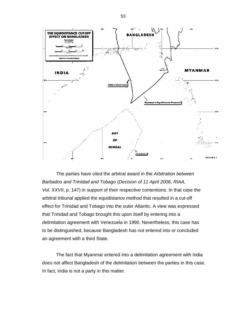
53
The parties have cited the arbitral award in the Arbitration between
Barbados and Trinidad and Tobago (Decision of 11 April 2006, RIAA,
Vol. XXVII, p. 147) in support of their respective contentions. In that case the
arbitral tribunal applied the equidistance method that resulted in a cut-off
effect for Trinidad and Tobago into the outer Atlantic. A view was expressed
that Trinidad and Tobago brought this upon itself by entering into a
delimitation agreement with Venezuela in 1990. Nevertheless, this case has
to be distinguished, because Bangladesh has not entered into or concluded
an agreement with a third State.
The fact that Myanmar entered into a delimitation agreement with India
does not affect Bangladesh of the delimitation between the parties in this case.
In fact, India is not a party in this matter.

54
The geographical factors in this case are unique. These include the
twin concavities, the coastal facade and the potential entitlement up to the
outer limits of the continental shelf.
I do not find that the equidistance principle suitable, because they
prevent Bangladesh from its entitlement to its continental shelf up to the “outer
limits “of the shelf. Consequently, any delimitation that denies/prevents
Bangladesh from exercising its entitlement to the continental shelf will not be
an equitable solution and in conformity with article 74 of the Convention.
The equidistance relevant circumstances method, in my opinion,
seems to be an adjustment of a provisional equidistance line to accommodate
a division that is equitable. However, this method set out in the principal
judgment, appears to be arbitrary. The line is fixed and then adjusted to meet
the requirement of achieving an equitable solution. The angle bisector method
takes into consideration macro geographical factors, the configuration of the
relevant coasts measured base lines and mathematical precision. The final
measurement ends at Cape Bhiff and not Point Negrais, which is more than
200 nm from the relevant base point. Therefore, I cannot agree with the view
that the decision to use the 215° azimuth line to determine the direction of the
adjustment to the provisional equidistance line is not based on the angle
bisector methodology either in principle or in the adoption of the particular
azimuth calculated by Bangladesh. I have used the angle bisector which in my
view is a clear mathematical calculation based on specific measurements of
the relevant coastlines and set base points.
I have found that the angle-bisector method of delimitation is the most
suitable in this matter for the reasons set out above.
Most importantly, the requirement in the law set out in articles 74 and
83 of the Convention:” to achieve an equitable solution” is paramount in
these circumstances. By using the angle-bisector method, I have been able to
achieve a just and equitable solution.

55
The “grey area” “a grey area” is an area lying within 200 nm from the coast of one State
but beyond a maritime with another state.” [See chart no.7 in the Judgment]
The following issue was raised with respect to delimitation of the EEZ
and Continental shelf in the so-called “grey area” [depicted in chart no. In the
Judement.] In this case the “grey area” stems from the fact that it falls within
the continental shelf of Bangladesh and also within the 200 nm EEZ of
Myanmar.
The Convention recognises two separate regimes with regard to the
EEZ and the Continental Shelf. The Specific legal regime of the exclusive
economic zone, the EEZ, is set out in Part V of the 1982 Convention. That of
the Continental Shelf is provided for in Part VI of the Convention.
The relevant articles in this issue are articles are article 56 of Part V
and article 76 of Part VI of the Convention.
The question is: How to address this issue?
Several views have been expressed. Firstly, in the oral submissions
Bangladesh, through Professor Crawford, submitted that this issue arises
whenerver there is a departure from the equidistance principle as has
occured in this case, where the equidistance, relevant circumstances, method
has been adopted and the angle-bisector method is proposed. In both
instances a “grey area” has been created.
Secondly, Myanmar argues that this matter is a non sequitor.
Professor Pellet submits that “Equitable delimitation which the Tribunal is
called upon to adjudicate, does not extend beyond 200 nm”: consequently,
there is no need to wonder what would happen in the “grey area”. He argued
“that the solution proposed by Bangladesh is untenable”.

56
In my opinion I think that Counsel for Myanmar did not fully address the
problem of resolving the issue. He contends that the Tribunal does not have
the jurisdiction to delimit any area beyond 200 nm.
Counsel for Bangladesh submitted that there is no jurisprudence to
guide the Tribunal on this issue. It was not fully addressed in the case
concerning the Delimitation of the Maritime Boundary in the Gulf of Maine
Area (Judgment, I.C.J. Reports 1984, p. 246) where the area is still not
resolved as well as by Tribunals in several cases including the Trinidad and
Tobago/Barbados Arbitral Award. The issue in this matter is “made even more
interesting by the fact that Bangladesh has an entitlement in the outer
continental shelf that overlaps with Myanmar’s 200 nm EEZ entitlement”.
The gist of Bangladesh’s argument is that the matter cannot be
resolved by giving priority to the EEZ over the continental shelf, but by giving
priority to the continental shelf over the EEZ.
It seems to me that the result of a strict interpretation of the law set out
in Parts V and VI of the Convention prohibits any allocation of one area to the
other. Specifically, the waters superjacent to the seabed and its subsoil of one
State may not be allocated to another State that is entitled to the seabed and
subsoil of the submarine areas (the continental shelf) of that State.This
interpretation may create difficulties in respect of fishing and exploration and
exploitation of the sea bed and subsoil.
It is not disputed that there are two separate and distinct regimes. It is
also not disputed that Bangladesh is entitled to the continental shelf in the
area while Myanmar’s 200 nm crosses bangladesh’s entitlement to its
continental shelf.
There are suggestions that the issues involving “grey areas” should be
left as an unresolved matters; or to indicate that there is such an area without
any comment, and/or suggest that the parties to negotiate and cooperate in
resolving the matter, either by an exchange of rights, or by agreeing to use
57
each others specified area with approved licences for fishing and exploration
and exploitation of resources in the seabed and subsoil. I think all of the
foregoing may lead to further problems and issues and may be regarded as a
failure on the part of the Tribunal to determine the issue. It must be recalled
that the parties have asked the Tribunal to delimit the overlapping territorial
sea, the EEZ and the continental Shelves of the Parties by a single line.
While prima facie, the relevant regimes of the exclusive economic zone
and the continental shelf do not supersede each other and, on the contrary,
are equal in all respects, in cases of delimitation where the respective regimes
apply, a judge has to consider, examine and interpret the provisions carefully
and determine whether there is a specific reference in the provisions of one
regime that could govern the other.
The Tribunal should deal with the issue and take a robust approach in
the interpretation and determine the true purport of the Law. Prima facie there
are no provisions in the Convention for allocation of entitlements over the EEZ
and the Continental from one State to another. However, I think a wide and
generous interpretation of article 56, paragraph 3, of the Convention could
resolve the problem.
Article 56, paragraph 3, specifies that: “The rights set out in this Article
with respect to the seabed and subsoil shall be exercised in accordance with Part VI.” (my emphasis)
Article 74 provides for delimitation of the EEZ between States with
opposite or adjacent coasts.
Article 83 provides for delimitation of the continental shelf between
adjacent States.
Both articles provide for the same solution, in that it must be an
equitable one. I think the distinctive facts in the case have to be considered. In
such circumstances. The judge has to take a pragmatic approach that
58
involves: the location of the said area; that there is de facto overlapping in the
area; that the parties have been negotiating for over 34 years on other issues
without a specific agreement; and, consider the “doctrine of necessity”, having
regard to the unique geographical circumstances of the Bay of Bengal.Further,
the regime of the continental shelf preceeds that of the EEZ and specifies
rights of entitlement. Such rights are inherent to the coastal state and cannot
be taken away.
If the “grey area” is allocated to Myanmar then Bangladesh will be
denied access to the outer continental shelf. If the said area is allocated to
Bangladesh then its entitlement to the outer continental shelf in the Bay of
Bengal will not be infringed.It is obvious that if the former is adopted,
Bangladesh will suffer the greater loss. Hence in my view here will not be the
equitable solution envisaged and prescribed by the relevant articles of the
Convention.
The Parties seek a solution to the dispute. Therefore, it seems to me
that if rights are to be governed by Part VI, and such rights are in an area that
is to be delimited, then article 83 will prevail. It seems to me that continental
shelf rights in the special circumstances of this case have priority over EEZ
rights. As a result I would allocate the “grey area” to Bangladesh. This is
depicted in the appended map.
The regime of the continental shelf began as far back as 1942 in the
Gulf of Paria Treaty 1942 between Great Britain and Venezuela , in that
Treaty the submarine areas of the Gulf of Paria were divided between the two
countries. By Annexation Orders each country annexed the submarine areas
as part of their territory.The superadjacent waters were not divided then in
1942. However, the real impetus began with the Truman Proclamation of
1945 in which the continental shelf was defined as follows:
POLICY OF THE UNITED STATES WITH RESPECT TO THE NATURAL RESOURCES OF THE SUBSOIL AND SEABED OF THE CONTINENTAL SHELF.
59
WHEREAS it is the view of the Government of the United States that the exercise of jurisdiction over the natural resources of the subsoil and sea bed of the continental shelf by the contiguous nation is reasonable and just, since the effectiveness of measures to utilize or conserve these resources would be contingent upon cooperation and protection from the shore, since the continental shelf may be regarded as an extension of the land-mass of the coastal nation and thus naturally appurtenant to it, since these resources frequently form a seaward extension of a pool or deposit lying within the territory, and since self-protection compels the coastal nation to keep close watch over activities off its shores which are of the nature necessary for utilization of these resources; 10 Fed. Reg. 12,305 (1945).
A definition was set out in the 1958 Convention on the Continental Shelf
(done at Geneva on 29 April 1958):
Article 1 For the purpose of these articles, the term “continental shelf” is used as referring (a) to the seabed and subsoil of the submarine areas adjacent to the coast but outside the area of the territorial sea, to a depth of 200 metres or, beyond that limit, to where the depth of the superjacent waters admits of the exploitation of the natural resources of the said areas; (b) to the seabed and subsoil of similar submarine areas adjacent to the coasts of islands.
The EEZ was established thereafter and and set out in Part V of the
Convention. the definition is specified article 55 of the Convention. I think the
regime of the Continental shelf must take precedence, moreso in cases of
delimitation as in the instant case. Article 53, paragraph 3, provides the
remedy.
Courts and Tribunals should take a robust approach and resolve the
matters referred to them. The Bay of Bengal is unique as I alluded to earlier
when dealing with the geographical features of the Bay. The sinuosity of the
coastline, the deltaic configuration and the double concavities all contribute to
the uniqueness of this area.
In respect of “grey areas”, courts and tribunals have been reluctant to
make definite pronouncements and have not addresses the matter. The
tribunal has focussed on the crucial issues and left this matter for further
60
adjudication. In other words, the matter is left in abeyance without comment,
with a suggestion that the Parties in the case should conduct further
negotiations and cooperate towards arriving at a solution.
The law as set out in the Convention is not precise. The Convention
provides for two regimes and sets out the manner in which disputed areas in
each should be delimited. However, there are no provisions to govern the
situation where the very regimes overlap, creating “grey areas”.
Where the law is not clear or there are no specific provisions, a judge
must be innovative. Where there is ambiguity or confusion with respect to
interpretation, the Judge should find a solution to resolve the problem. If the
law does not specify a solution, then the judge must, by applying the law find
one.
A State is entitled to its continental shelf as defined in the Convention.
The regime of the continental shelf existed before the regime of the exclusive
economic zone and in my view must take precedence. The continental shelf
includes the seabed and subsoil therefore, it supersedes the EEZ. A judge
must be innovative and creative in these circumstances and fill the void if
there is one and here there is. A doctrine similar to the doctrine of necessity is
relevant. I therefore allocate the grey area to Bangladesh.
The Commission on the Limits of the Continental Shelf (CLCS) The Tribunal has a duty to adjudicate. Its role is not constrained by the
CLCS (Article 76, paragraph 8, of UNCLOS). The CLCS is not a Court. It has
an advisory role and makes recommendations. This article clearly prescribes
that the Commission can only issue recommendations and that these are only
“final and binding if the State consents. The said article further stipulates that
“in the case of disagreement by the coastal State with the recommendations
of the Commission, the coastal State shall within a reasonable time make a
new submission to the Commission.” Therefore, a State may challenge the

61
recommendation of the CLCS. A judgment of this Tribunal cannot be
challenged in another Court.
I have noted that article 2, paragraph 1, of the Annex of the Convention
provides that the Commission members are selected as experts in the field of
geology, geophysics or hydrography. The members are not called upon to
have any legal expertise. The tribunal comprises inter alia “persons of
recognised competence in the field of the law of the seas”. Judges are
qualified to accept and analyse evidence. The scientific evidence before this
Court was not challenged, in other words, the scientific evidence is irrefutable.
I also think that it is important to note that disputes under article 76 fall
within the purview of Part XV of the Convention. There is even the possibility if
a recommendation is challenged by a State, this Tribunal may have to declare
whether the recommendation is invalid.
I see no reason why the Court may not use the evidence to arrive at a
conclusion.
Article 9 of Annex II of the Convention provides:
The actions of the Commission shall not prejudice matters relating to the delimitation of boundaries between States with opposite or adjacent coasts.
Therefore, there is no reason for this Tribunal to await any
recommendation of the CLCS.
The Tribunal is an independent court. Its decisions are final and
binding on the parties in the case. It is not subject to any other court or
Tribunal. Its primary object is to consider and determine a case, based of
course, on the applicable Law, the Convention and the relevant persuasive
jurisprudence. Consideration of evidence is crucial in a Court.

62
I do not and will not agree to any “rider” or proviso to the decision, e.g.
as suggested:
subject to consideration of the delineation of the outer continental shelf by the CLCS” or “without prejudice to the final decision of the CLCS with respect to the respective applications.
As I alluded to earlier, there is sufficient scientific evidence before the
Tribunal to determine the extent of the continental shelf in respect of each
party. (See article 76 of the Convention and the Expert Reports of Drs. Curray
and Kudrass.) Therefore, the Tribunal can determine entitlement up to the
“outer limits” of the continental shelf.
I find no substance in the argument that this Tribunal does not have the
jurisdiction to delimit the continental shelf in the Bay of Bengal beyond 200 nm.
The Parties have agreed to the jurisdiction and the scientific and technical
evidence is provided in the reports of the experts.
Therefore, I am of the opinion that Bangladesh is entitled to a
continental shelf (a continuation of its land mass up to the outer limit of the
continental shelf.) Once more I repeat the evidence of the experts,
Drs. Kudrass and Curray are crucial. In fact the Reports and appended
documents are sufficient evidence for this Tribunal to determine the extent of
the continental shelf up to Bangladesh’s outer continental shelf (2,500 meter
isobath) (see article 76, paragraph 5, of the Convention).
Maps and charts are set out in the Judgment, with the exception of the
chart on the appendix depicting the delimitation line based on the angle-
bisector method) There is no need to set them out in this Separate Opinion.
Conclusion In conclusion, I find it necessary to set out my findings for the reasons
set out above.
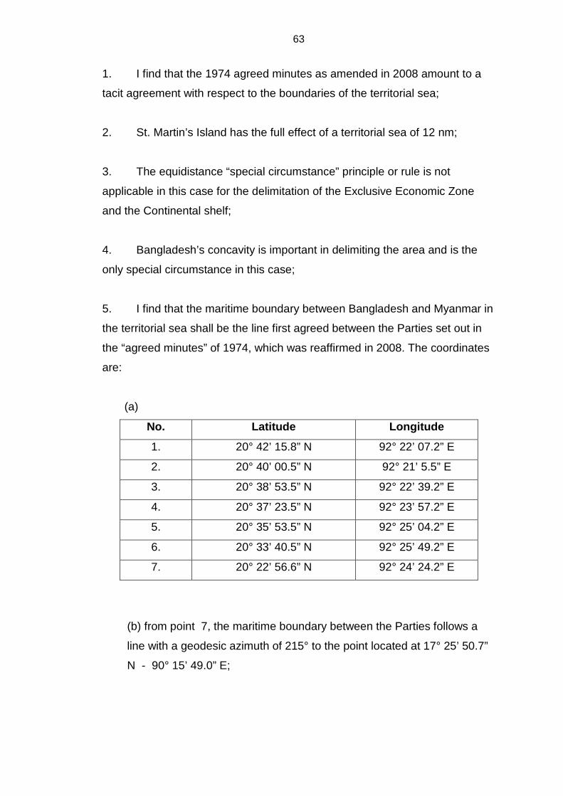
63
1. I find that the 1974 agreed minutes as amended in 2008 amount to a
tacit agreement with respect to the boundaries of the territorial sea;
2. St. Martin’s Island has the full effect of a territorial sea of 12 nm;
3. The equidistance “special circumstance” principle or rule is not
applicable in this case for the delimitation of the Exclusive Economic Zone
and the Continental shelf;
4. Bangladesh’s concavity is important in delimiting the area and is the
only special circumstance in this case;
5. I find that the maritime boundary between Bangladesh and Myanmar in
the territorial sea shall be the line first agreed between the Parties set out in
the “agreed minutes” of 1974, which was reaffirmed in 2008. The coordinates
are:
(a)
No. Latitude Longitude
1. 20° 42’ 15.8” N 92° 22’ 07.2” E
2. 20° 40’ 00.5” N 92° 21’ 5.5” E
3. 20° 38’ 53.5” N 92° 22’ 39.2” E
4. 20° 37’ 23.5” N 92° 23’ 57.2” E
5. 20° 35’ 53.5” N 92° 25’ 04.2” E
6. 20° 33’ 40.5” N 92° 25’ 49.2” E
7. 20° 22’ 56.6” N 92° 24’ 24.2” E
(b) from point 7, the maritime boundary between the Parties follows a
line with a geodesic azimuth of 215° to the point located at 17° 25’ 50.7”
N - 90° 15’ 49.0” E;
64
6. The Reports of the experts are evidence in the case. The reports
specify that the continental shelf of both states extend into the Bay of Bengal.
I find that based on the reports of the experts Myanmar is entitled to its
continental shelf beyond 200 nm and shares it with Bangladesh.
Consequently, I have divided the said area between the Sates in accordance
with the angle-bisector method. That is from the point 7 in the chart. The
maritime boundary follows a line with the geodesic azimuth of 215°;
7. Scientific evidence is permissible and is crucial in arriving at the
meaning of “natural prolongation” in article 76 of the Convention;
8. The continental shelf of Bangladesh is the natural prolongation of the
landmass into the Bay of Bengal;
9. The angle-bisector method depicts the line delimiting the maritime
boundary between Bangladesh and Myanmar in the Bay of Bengal;
10. Applying the above method the test of disproportionality is met;
11. The “grey area” must be divided and for the reasons set out in this
opinion. I allocate the “grey area” to Bangladesh;
12. The delimitation line beyond 200 nm is the continuation of the line
dividing the EEZ and the continental shelf of the States until it reaches the
point where the rights of a third State may be affected.
(signed)
Anthony Amos Lucky