introduction - nagpur metrometrorailnagpur.com/dpr-pdf/chapter1.pdftherefore named "nag",...
TRANSCRIPT
CHAPTER 1
1.1 BACKGROUND 1.1.1 FACTS ABOUT NAGPUR 1.1.2 DEMOGRAPHICS 1.1.3 VEHICLE POPULATION IN NAGPUR CITY 1.1.4 RAIL AND AIR TRANSPORT IN NAGPUR CITY 1.1.5 POINTS FROM OTHER FEASIBILITY SURVEY DONE FOR NAGPUR 1.1.6 ALIGNMENTS PROPOSED BY DMRC 1.2 STRUCTURE OF THE PROJECT REPORT TABLES TABLE 1.1 A CENSUS INDIA, POPULATION OF NAGPUR CITY IN 2011 TABLE 1.1 B CENSUS INDIA, POPULATION OF NAGPUR METROPOLITAN IN 2011 TABLE 1.1 C POPULATION GROWTH RATE OF NAGPUR CITY FOR LAST FIVE DECADES TABLE 1.2 MOTOR VEHICLES POPULATION ON ROAD IN NAGPUR CITY TABLE 1.3 RIDERSHIP ESTIMATION FOR VARIOUS ALIGNMENTS
(BASED ON THE STUDY DONE BY L&T-RAMBOLL CONSULTING ENGINEERS LIMITED) TABLE 1.4 ALIGNMENT PROPOSED BY DMRC TABLE 1.5 FINAL ALIGNMENT FIGURES FIG. 1.1 INDEX PLAN OF THE PROPOSED NAGPUR METRO RAIL FIG. 1.2 ALIGNMENT-1 OF MRTS CORRIDORS PROPOSED BY L&T-RAMBOLL CONSULTING
ENGINEERS LIMITED FIG. 1.3 ALIGNMENT-2 OF MRTS CORRIDORS PROPOSED BY L&T-RAMBOLL CONSULTING
ENGINEERS LIMITED FIG. 1.4 ALIGNMENT-3 OF MRTS CORRIDORS PROPOSED BY L&T-RAMBOLL CONSULTING
ENGINEERS LIMITED FIG. 1.5 ALIGNMENT-4 OF MRTS CORRIDORS PROPOSED BY L&T-RAMBOLL CONSULTING
ENGINEERS LIMITED
INTRODUCTION
DETAILED PROJECT REPORT FOR NAGPUR METRO RAIL PROJECT NOV 2013
1/16
CHAPTER-1 INTRODUCTION
1.1 BACKGROUND
1.1.1 FACTS ABOUT NAGPUR
Nagpur is the third largest city of Maharashtra and also the winter capital of the state. With a population of approximately 25 lakhs, Nagpur Metropolitan Area is the 13th largest urban conglomeration in India. It has also recently been ranked as the cleanest city and the second greenest city of India. In addition to being the seat of annual winter session of Maharashtra state assembly "Vidhan Sabha", Nagpur is also a major commercial and political center of the Vidarbha region, It is also known as "Orange City" for being a major trade center of oranges that are cultivated in the region.
Nagpur lies precisely at the center of the country with the Zero Mile Marker indicating the geographical center of India. The city was founded by the Gonds but later became part of the Maratha Empire under the Bhonsles. The British East India Company took over Nagpur in the 19th century and made it the capital of the Central Provinces and Berar. After the first reorganisation of states, the city lost its capital status but according to the informal "Nagpur Pact" between political leaders, it was made the second capital of Maharashtra. Nagpur is also declared, "Tiger Capital of India " as it connects many Tiger Reserves in India to the world.
Etymology The Nag River, a tributary of the Kanhan River, flows in a serpentine path and is therefore named "Nag", the Marathi word for snake. And hence, the river and city is named as Nagpur. During British times the city used to be referred to as Nagpore. While others says that the river flows through the old city of Nagpur and hence the city is named after this river. "Pur" is a common suffix given to cities, villages and towns across India, and is often simply translated "city". The seal of Nagpur Municipal Corporation depicts a cobra in the water of a river
Chapter 1: Introduction
DETAILED PROJECT REPORT FOR NAGPUR METRO RAIL PROJECT NOV 2013
2/16
Geography and Climate
Geography
Nagpur lies on the Deccan plateau of the Indian Peninsula and has a mean altitude of 310.5 meters above sea level.The underlying rock strata are covered with alluvial deposits resulting from the flood plain of the Kanhan River. In some places these give rise to granular sandy soil. In low lying areas which are poorly drained, the soil is alluvial clay with poor permeability characteristics. In the eastern part of city crystalline metamorphic rocks such as gneiss, schist and granites are found, while in the northern part yellowish sand stones and clays of the lower Gondwana formations are found.
Nagpur city is dotted with natural and man-made lakes with Ambazari lake being the largest. Other natural lakes include Gorewada Lake and Telangkhedi lake. Sonegaon lake and Gandhisagar lake are man-made lakes created by the city's historical rulers. Nag river, Pilli nadi along with nallas form the natural drainage pattern for the city. Nagpur is known for its greenery, and was judged as the cleanest and second greenest in India after Chandigarh.. Recently, Government of India selected Nagpur as a Model City for National Clean Air Mission by allocating 25 crores for the plan. This project will be handled by Nagpur's own NEERI (National Environmental Engineering Research Institute).
Climate As it is located at centre of Indian peninsula far from the Bay of Bengal and the Arabian Sea, Nagpur has a tropical wet and dry climate with dry conditions prevailing for most of the year. It receives an annual rainfall of 1,205 mm (47.44 in) from monsoon rains during June to September. The highest recorded rainfall was 304 mm on 14 July 1994. Summers are extremely hot lasting from March to June, with maximum temperatures occurring in May. Winter lasts from November to January, during which temperatures can drop below 10 °C (50 °F). The highest ever recorded temperature in the city is 49°C, while the lowest is 3°C.
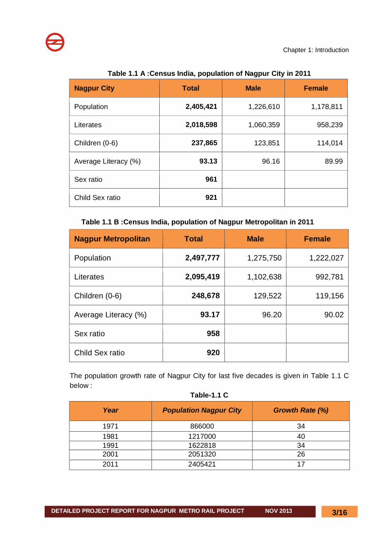
1.1.2 DEMOGRAPHICS As per provisional reports of Census India, population of Nagpur in 2011 is 2,405,421; of which male and female are 1,226,610 and 1,178,811 respectively. Although Nagpur city has population of 2,405,421; its urban UA / metropolitan population is 2,497,777 of which 1,275,750 are males and 1,222,027 are females1. Details of population of Nagpur city and Nagpur Metropolitan Area are given in Table 1.1 A, 1.1B
1 http://www.census2011.co.in/census/city/353-nagpur.html
Chapter 1: Introduction
DETAILED PROJECT REPORT FOR NAGPUR METRO RAIL PROJECT NOV 2013
3/16
Table 1.1 A :Census India, population of Nagpur City in 2011
Nagpur City Total Male Female
Population 2,405,421 1,226,610 1,178,811
Literates 2,018,598 1,060,359 958,239
Children (0-6) 237,865 123,851 114,014
Average Literacy (%) 93.13 96.16 89.99
Sex ratio 961
Child Sex ratio 921
Table 1.1 B :Census India, population of Nagpur Metropolitan in 2011
Nagpur Metropolitan Total Male Female
Population 2,497,777 1,275,750 1,222,027
Literates 2,095,419 1,102,638 992,781
Children (0-6) 248,678 129,522 119,156
Average Literacy (%) 93.17 96.20 90.02
Sex ratio 958
Child Sex ratio 920 The population growth rate of Nagpur City for last five decades is given in Table 1.1 C below :
Table-1.1 C
Year Population Nagpur City Growth Rate (%)
1971 866000 34 1981 1217000 40 1991 1622818 34 2001 2051320 26 2011 2405421 17
Chapter 1: Introduction
DETAILED PROJECT REPORT FOR NAGPUR METRO RAIL PROJECT NOV 2013
4/16
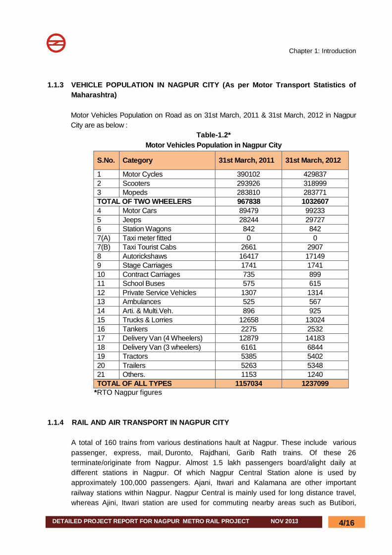
1.1.3 VEHICLE POPULATION IN NAGPUR CITY (As per Motor Transport Statistics of
Maharashtra)
Motor Vehicles Population on Road as on 31st March, 2011 & 31st March, 2012 in Nagpur City are as below :
Table-1.2* Motor Vehicles Population in Nagpur City
S.No. Category 31st March, 2011 31st March, 2012
1 Motor Cycles 390102 429837 2 Scooters 293926 318999 3 Mopeds 283810 283771 TOTAL OF TWO WHEELERS 967838 1032607 4 Motor Cars 89479 99233 5 Jeeps 28244 29727 6 Station Wagons 842 842 7(A) Taxi meter fitted 0 0 7(B) Taxi Tourist Cabs 2661 2907 8 Autorickshaws 16417 17149 9 Stage Carriages 1741 1741 10 Contract Carriages 735 899 11 School Buses 575 615 12 Private Service Vehicles 1307 1314 13 Ambulances 525 567 14 Arti. & Multi.Veh. 896 925 15 Trucks & Lorries 12658 13024 16 Tankers 2275 2532 17 Delivery Van (4 Wheelers) 12879 14183 18 Delivery Van (3 wheelers) 6161 6844 19 Tractors 5385 5402 20 Trailers 5263 5348 21 Others. 1153 1240 TOTAL OF ALL TYPES 1157034 1237099
*RTO Nagpur figures
1.1.4 RAIL AND AIR TRANSPORT IN NAGPUR CITY A total of 160 trains from various destinations hault at Nagpur. These include various passenger, express, mail, Duronto, Rajdhani, Garib Rath trains. Of these 26 terminate/originate from Nagpur. Almost 1.5 lakh passengers board/alight daily at different stations in Nagpur. Of which Nagpur Central Station alone is used by approximately 100,000 passengers. Ajani, Itwari and Kalamana are other important railway stations within Nagpur. Nagpur Central is mainly used for long distance travel, whereas Ajini, Itwari station are used for commuting nearby areas such as Butibori,
Chapter 1: Introduction
DETAILED PROJECT REPORT FOR NAGPUR METRO RAIL PROJECT NOV 2013
5/16
Ramtek etc. The city is the Divisional Head Quarters for the Central Railway and South East Central Railway Zone of Indian Railways. The Airport handles around 4,000 passengers per day and caters to 6 Domestic Airlines connecting Nagpur to 12 domestic destinations including Mumbai, Delhi, Pune, Kolkata, Hyderabad, Raipur etc and a few (connecting flights) International Airline to Singapore etc.
1.1.5 POINTS FROM OTHER FEASIBILITY SURVEY DONE FOR NAGPUR 1.1.5.1 The Nagpur Municipal Corporation (NMC) had awarded the project titled “Preparation
of Master Plan/Perspective Plan for Transportation System of Nagpur City 2031” to L&T-Ramboll Consulting Engineers Limited in June 2007. The study aims to update the long-term transportation strategy for NMC and identify a practicable and effective investment programme up to 2031. Consultants commenced the study in the month of June,2007 and completed in June,2008. L&T Ramboll Consulting Engineers Limited had carried out the Comprehensive Traffic and Transportation Study and prepared Transportation Master Plan for Nagpur city commissioned by NMC. As a part of study consultants had 1. Reviewed all the relevant secondary data related to landuse, travel pattern
and demographics, supply of transport infrastructure and road safety etc.Major traffic generators such as MIHAN (Multi-modal International Cargo Hub and Airport at Nagpur), Industrial Areas such as Butibori and Higna etc were taken into account to forecast future population and employment.
2. Conducted primary traffic surveys including household surveys (2% of sample households)
3. Developed Travel demand models using the TRIPS/CUBE Software and validated for the base year and using the validated software forecasted travel demand for 2011,2021 and 2031 for two scenarios (do nothing) and do something (improved public transportation scenario)
4. Based on the outputs of travel demand models and studying the availability of present transportation infrastructure consultants have recommended short term,medium term and long term improvement proposals to be implemented from 2009-2031.
1.1.5.2 Salient Features of Nagpur Current Traffic and Transportation Scenario
(L&T-Ramboll study) : Nagpur is the second capital of Maharashtra and is located in the geo-graphical
centre of India with good road and rail network. Nagpur acts as transhipment place for areas like Chattisgarh and Eastern
Maharashtra 2008 population of NMC as 24.47 lakhs and average density as 112 pph. (as per
report)
Chapter 1: Introduction
DETAILED PROJECT REPORT FOR NAGPUR METRO RAIL PROJECT NOV 2013
6/16
Main public transport providers are MSRTC,BOT bus operator (Star Bus). Poor public transportation system (less than 5% of the total trips). Non-motorised modes walk and bicycle constitutes 58% of total trips. Motorised transport is dominated by two wheelers (28%). Predominant on-street parking and absence of off-street parking facilities. Current Vehicle Ownership is 11.57 lakh in which 9.67 lakhs are two wheelers. Poor mobility in some of the areas such as Itwari. Absence of truck terminals as Nagpur is proposed as future Road Cargo hub. Development of Multi-Modal Hub Airport in Nagpur (MIHAN) in 4354 hectares is
underway.
1.1.5.3 Some of the important findings of the L&T-Ramboll study are as follows : Forecasted population of NMC by for 2021 and 2031 is 35.4 lakhs and 46.7 lakhs
respectively. Forecasted Employment of NMC by for 2021 and 2031 is 12.4 lakhs and 16.8
lakhs respectively. MIHAN is going to generate around 2.6 lakhs employment by 2015 (fully
operational) and 4.3 lakhs by 2031. Total trips made by the residents of Nagpur in 2007 is 25.57 lakhs (without
intra-zonal) and expected to increase to 55 lakhs by 2031.
1.1.5.4 Transportation Improvement proposals (L&T-Ramboll study) are broadly classified into three categories based on the time horizon: Short Term Improvement Proposals (2008-2009) Medium Term Improvement Proposals (2009-2021) Phase-I (2009-2011) Phase-II (2012-2016) Phase-II (2017-2021) Long Term Improvement Proposals (2022-2031
1.1.5.5 Some of the important proposals recommended by L&T-Ramboll
Consulting Engineers Limited are: Improved bus system with a fleet comprising of Standard buses and Mini-buses.
Standard buses will serve the major corridors whereas mini-bus services act as a feeder services and low demand corridors. In Short term (with in a year) fleet size of 275 buses (225 Standard buses and 50 mini buses) needs to be deployed to serve 2.5 lakhs passengers per day. In medium term (with 2 to 3 years) 500 buses needs to be deployed to serve 5 lakh passengers/day.In long term say by 2016, 750 buses needs to be deployed to serve 7.5 lakhs passengers/day.Coverage Area of Buses should be improved to 90% ( At present it is less than 40%).
Improved pedestrian facilities with min 2.5 m footpaths and FOBs/Subways. Bicycle lanes on pilot basis on several wide roads.
Chapter 1: Introduction
DETAILED PROJECT REPORT FOR NAGPUR METRO RAIL PROJECT NOV 2013
7/16
Off-street parking facilities near important areas such as commercial areas, office areas, special generators such as religious places etc on PPP model especially in Sitabuldi, Sadar areas, transport terminals and at Ganeshpeth bus terminal.
Construction of ROBs/RUBs/Bridges across rivers/flyovers. Development of Inner-Circle ring road and Alternative-north-South corridor to take
predominately north-south demand. Improvement of Radial Roads such as Wardha Road to 6-lane configuration from
existing 4-lane configuration by 2016. Inner Ring Road to be improved to 6-lane configuration with service road by 2016. Outer ring road to be planned after 2016.It will be funded by State and Central
Governments. Construction of MRTS in phases 2012-16 and 2017-2021. It is envisaged 65 km
of MRTS and 20 km commuter rail by 2031. Development of truck terminals at four places on PPP basis at Inner /Outer Ring
Road. Creation of public transport infrastructure bus terminals/depots/bus procurement
etc. Environment friendly policies such as use of CNG, favourable policies for public
transport, more conducive environment for walking and bicycles. Development of Bus Terminals/Transport Terminals at Outer ring road. Additional BRTS/ MRTS Corridors in long term. Road Corridor parallel to Railway line to serve north-south traffic (feasibility to be
ascertained). Development of Commuter rail system from Nagpur city to Butibori on the similar
lines of Multi Modal Transport System (MMTS) in Hyderabad. Itwari Area redevelopment.
1.1.5.6 MRTS Corridors Proposed by L&T-Ramboll Consulting Engineers Limited
Several corridors of MRTS were studied and presented by L&T-Ramboll Consulting Engineers Limited. in their report.
Four different MRTS options were considered. The description of each alignment was presented in Chapter 4 of their report. Four different MRTS alignment options considered are :
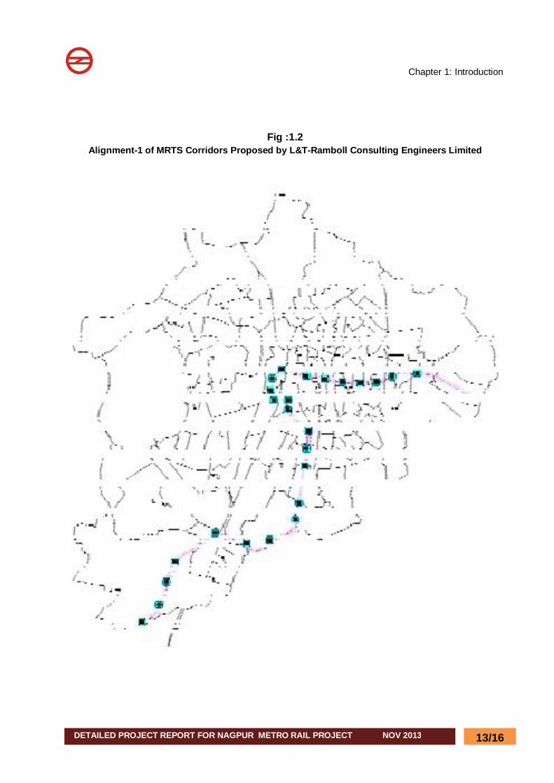
Alignment-1 : Pardi Naka to Dahegoan ( 24.54 km with 25 Stations). The alignment option -1 starts at Pardi Naka and ends at Dahegaon. It passes through Central Avenue road, Central railway station, Ganeshpet Bus stand, Medical Chowk, Manewada Jn etc. (Fig :1.2)
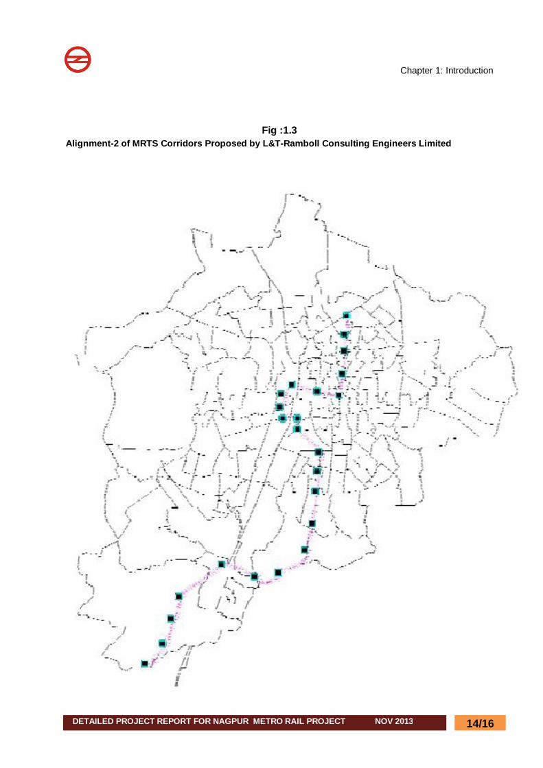
Alignment-2 : Automotive Square to Dahegoan ( 23.94 km with 24 Stations) The alignment option -2 is starts at Automotive Square and ends at Dahegaon. It
Chapter 1: Introduction
DETAILED PROJECT REPORT FOR NAGPUR METRO RAIL PROJECT NOV 2013
8/16
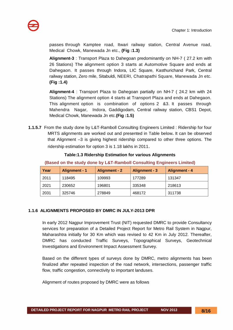
passes through Kamptee road, Itwari railway station, Central Avenue road, Medical Chowk, Manewada Jn etc., (Fig :1.3)
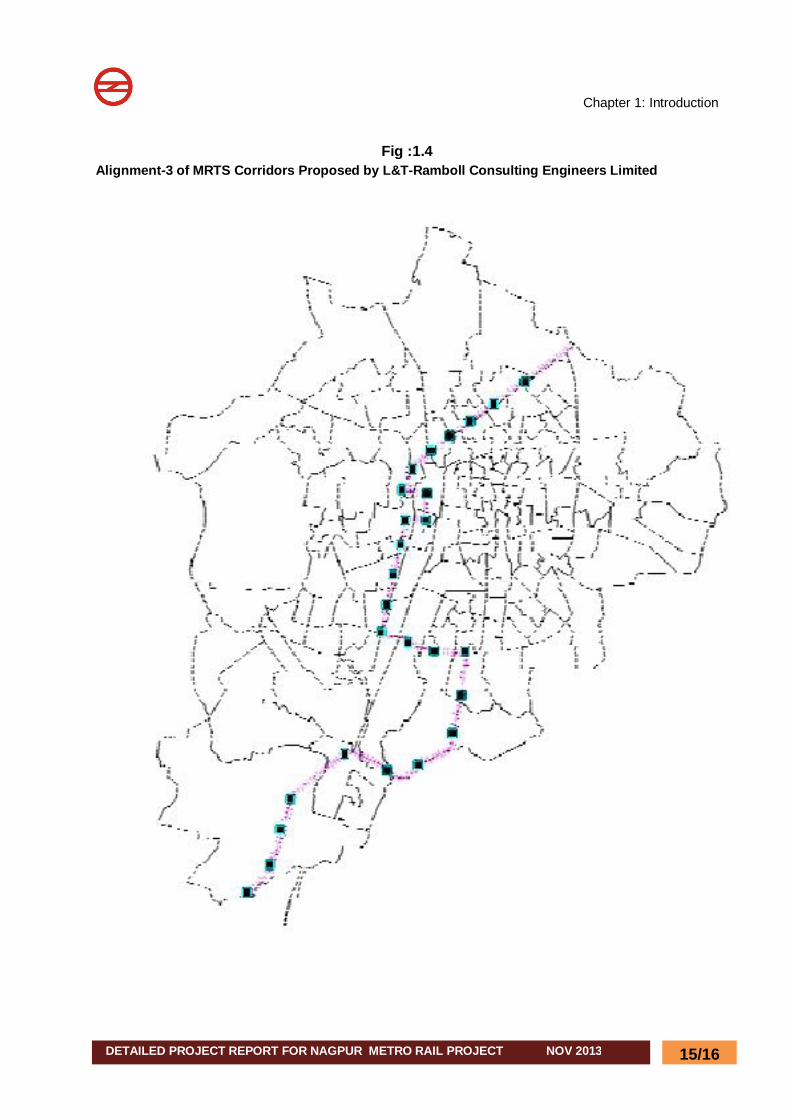
Alignment-3 : Transport Plaza to Dahegoan predominantly on NH-7 ( 27.2 km with 26 Stations) The alignment option 3 starts at Automotive Square and ends at Dahegaon. It passes through Indora, LIC Square, Kasthurichand Park, Central railway station, Zero mile, Sitabuldi, NEERI, Chatrapathi Square, Manewada Jn etc. (Fig :1.4)
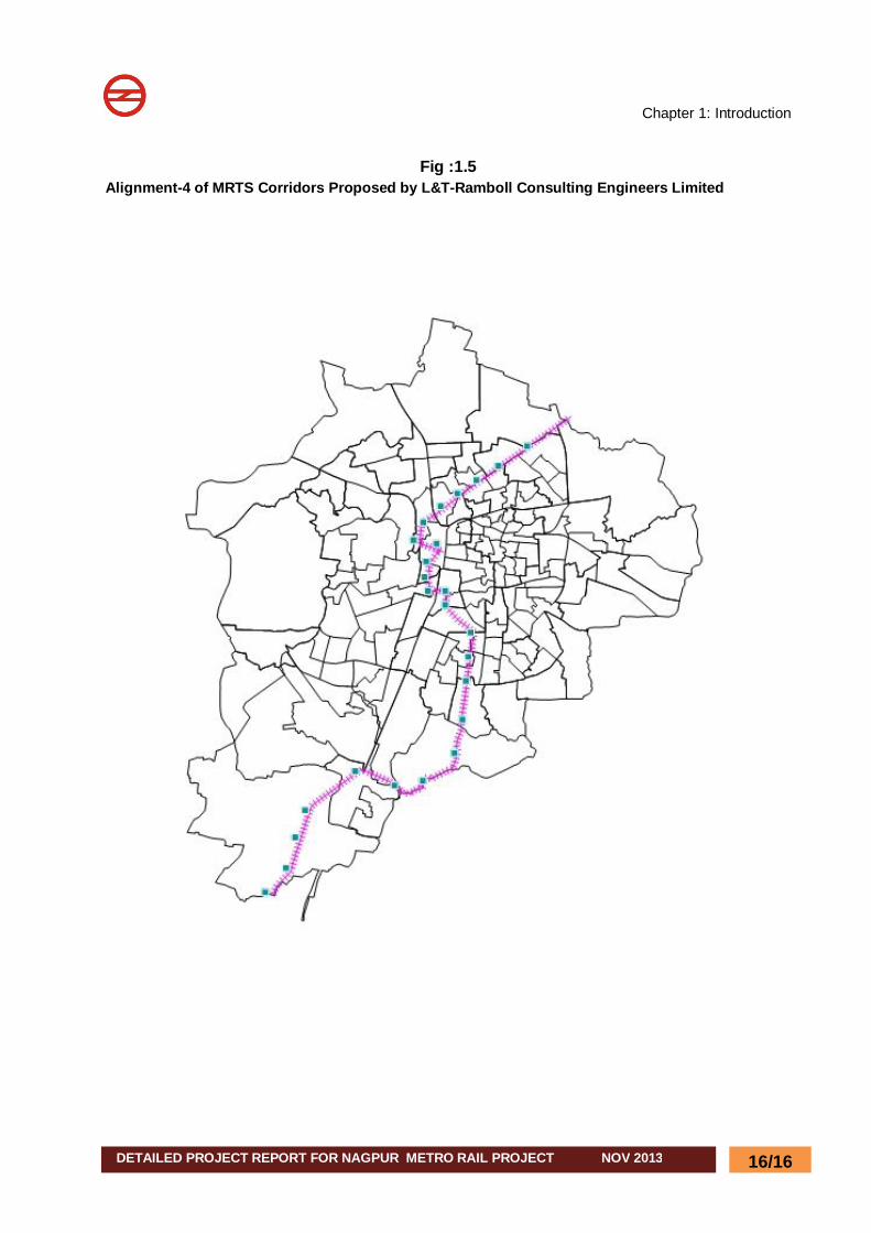
Alignment-4 : Transport Plaza to Dahegoan partially on NH-7 ( 24.2 km with 24 Stations) The alignment option 4 starts at Transport Plaza and ends at Dahegaon. This alignment option is combination of options 2 &3. It passes through Mahendra Nagar, Indora, Gaddigodam, Central railway station, CBS1 Depot, Medical Chowk, Manewada Jn etc.(Fig :1.5)
1.1.5.7 From the study done by L&T-Ramboll Consulting Engineers Limited : Ridership for four
MRTS alignments are worked out and presented in Table below. It can be observed that Alignment –3 is giving highest ridership compared to other three options. The ridership estimation for option 3 is 1.18 lakhs in 2011.
Table:1.3 Ridership Estimation for various Alignments
(Based on the study done by L&T-Ramboll Consulting Engineers Limited)
Year Alignment - 1 Alignment - 2 Alignment - 3 Alignment - 4
2011 118495 109993 177289 131347
2021 230652 196801 335348 218613
2031 325746 278849 468172 311738 1.1.6 ALIGNMENTS PROPOSED BY DMRC IN JULY-2013 DPR
In early 2012 Nagpur Improvement Trust (NIT) requested DMRC to provide Consultancy services for preparation of a Detailed Project Report for Metro Rail System in Nagpur, Maharashtra initially for 30 Km which was revised to 42 Km in July 2012. Thereafter, DMRC has conducted Traffic Surveys, Topographical Surveys, Geotechnical Investigations and Environment Impact Assessment Survey. Based on the different types of surveys done by DMRC, metro alignments has been finalized after repeated inspection of the road network, intersections, passenger traffic flow, traffic congestion, connectivity to important landuses. Alignment of routes proposed by DMRC were as follows
Chapter 1: Introduction
DETAILED PROJECT REPORT FOR NAGPUR METRO RAIL PROJECT NOV 2013
9/16
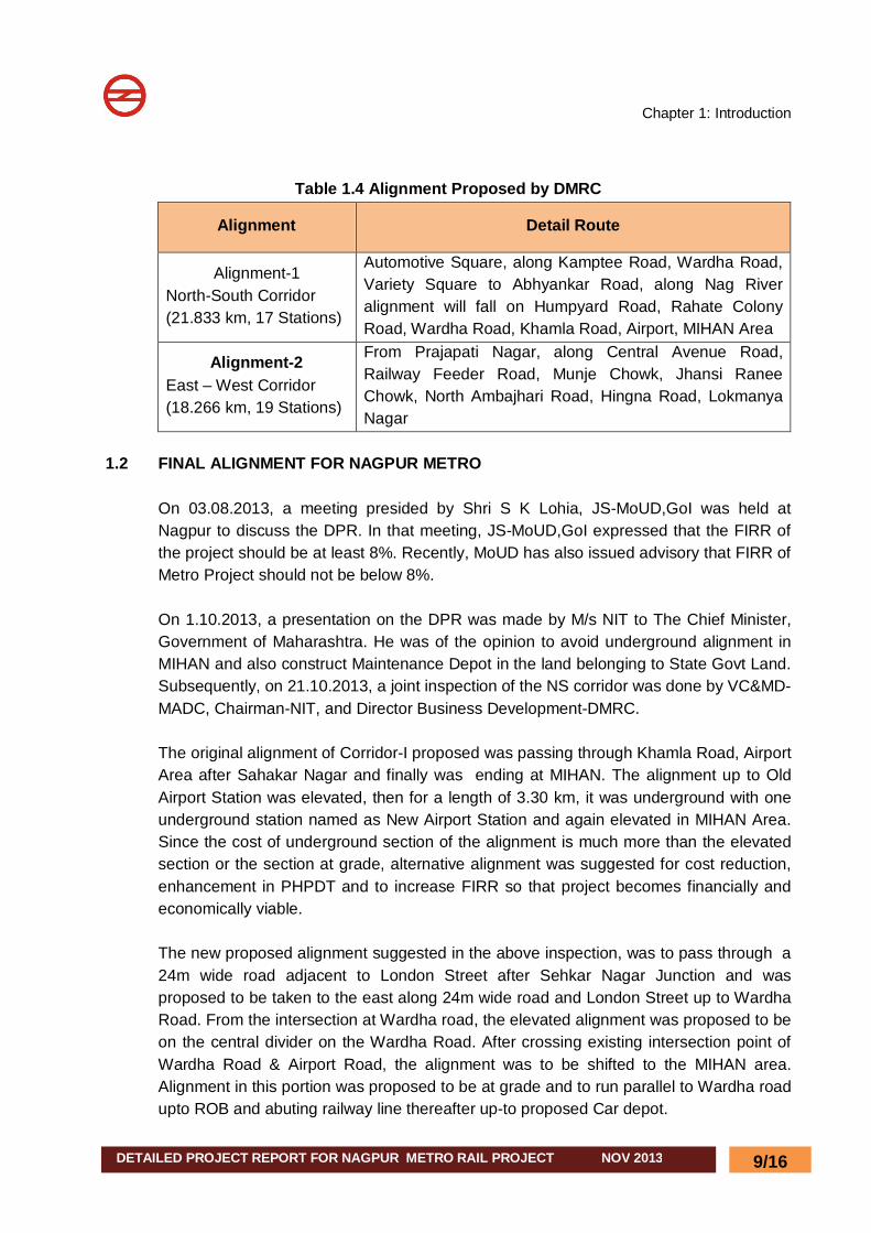
Table 1.4 Alignment Proposed by DMRC
Alignment Detail Route
Alignment-1 North-South Corridor (21.833 km, 17 Stations)
Automotive Square, along Kamptee Road, Wardha Road, Variety Square to Abhyankar Road, along Nag River alignment will fall on Humpyard Road, Rahate Colony Road, Wardha Road, Khamla Road, Airport, MIHAN Area
Alignment-2 East – West Corridor (18.266 km, 19 Stations)
From Prajapati Nagar, along Central Avenue Road, Railway Feeder Road, Munje Chowk, Jhansi Ranee Chowk, North Ambajhari Road, Hingna Road, Lokmanya Nagar
1.2 FINAL ALIGNMENT FOR NAGPUR METRO
On 03.08.2013, a meeting presided by Shri S K Lohia, JS-MoUD,GoI was held at Nagpur to discuss the DPR. In that meeting, JS-MoUD,GoI expressed that the FIRR of the project should be at least 8%. Recently, MoUD has also issued advisory that FIRR of Metro Project should not be below 8%. On 1.10.2013, a presentation on the DPR was made by M/s NIT to The Chief Minister, Government of Maharashtra. He was of the opinion to avoid underground alignment in MIHAN and also construct Maintenance Depot in the land belonging to State Govt Land. Subsequently, on 21.10.2013, a joint inspection of the NS corridor was done by VC&MD-MADC, Chairman-NIT, and Director Business Development-DMRC. The original alignment of Corridor-I proposed was passing through Khamla Road, Airport Area after Sahakar Nagar and finally was ending at MIHAN. The alignment up to Old Airport Station was elevated, then for a length of 3.30 km, it was underground with one underground station named as New Airport Station and again elevated in MIHAN Area. Since the cost of underground section of the alignment is much more than the elevated section or the section at grade, alternative alignment was suggested for cost reduction, enhancement in PHPDT and to increase FIRR so that project becomes financially and economically viable. The new proposed alignment suggested in the above inspection, was to pass through a 24m wide road adjacent to London Street after Sehkar Nagar Junction and was proposed to be taken to the east along 24m wide road and London Street up to Wardha Road. From the intersection at Wardha road, the elevated alignment was proposed to be on the central divider on the Wardha Road. After crossing existing intersection point of Wardha Road & Airport Road, the alignment was to be shifted to the MIHAN area. Alignment in this portion was proposed to be at grade and to run parallel to Wardha road upto ROB and abuting railway line thereafter up-to proposed Car depot.
Chapter 1: Introduction
DETAILED PROJECT REPORT FOR NAGPUR METRO RAIL PROJECT NOV 2013
10/16
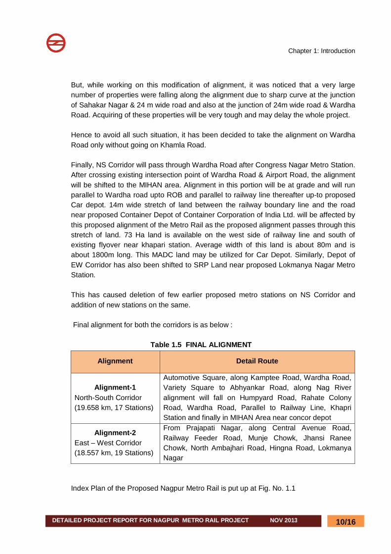
But, while working on this modification of alignment, it was noticed that a very large number of properties were falling along the alignment due to sharp curve at the junction of Sahakar Nagar & 24 m wide road and also at the junction of 24m wide road & Wardha Road. Acquiring of these properties will be very tough and may delay the whole project. Hence to avoid all such situation, it has been decided to take the alignment on Wardha Road only without going on Khamla Road. Finally, NS Corridor will pass through Wardha Road after Congress Nagar Metro Station. After crossing existing intersection point of Wardha Road & Airport Road, the alignment will be shifted to the MIHAN area. Alignment in this portion will be at grade and will run parallel to Wardha road upto ROB and parallel to railway line thereafter up-to proposed Car depot. 14m wide stretch of land between the railway boundary line and the road near proposed Container Depot of Container Corporation of India Ltd. will be affected by this proposed alignment of the Metro Rail as the proposed alignment passes through this stretch of land. 73 Ha land is available on the west side of railway line and south of existing flyover near khapari station. Average width of this land is about 80m and is about 1800m long. This MADC land may be utilized for Car Depot. Similarly, Depot of EW Corridor has also been shifted to SRP Land near proposed Lokmanya Nagar Metro Station. This has caused deletion of few earlier proposed metro stations on NS Corridor and addition of new stations on the same. Final alignment for both the corridors is as below :
Table 1.5 FINAL ALIGNMENT
Alignment Detail Route
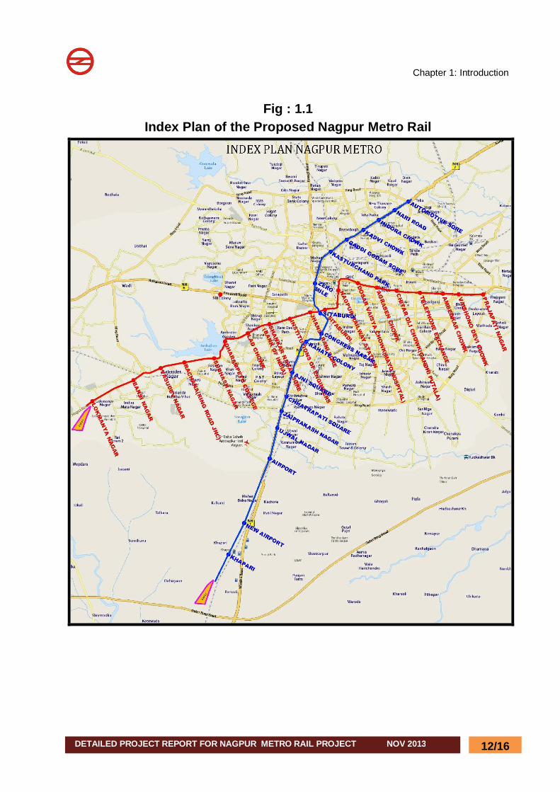
Alignment-1 North-South Corridor (19.658 km, 17 Stations)
Automotive Square, along Kamptee Road, Wardha Road, Variety Square to Abhyankar Road, along Nag River alignment will fall on Humpyard Road, Rahate Colony Road, Wardha Road, Parallel to Railway Line, Khapri Station and finally in MIHAN Area near concor depot
Alignment-2 East – West Corridor (18.557 km, 19 Stations)
From Prajapati Nagar, along Central Avenue Road, Railway Feeder Road, Munje Chowk, Jhansi Ranee Chowk, North Ambajhari Road, Hingna Road, Lokmanya Nagar
Index Plan of the Proposed Nagpur Metro Rail is put up at Fig. No. 1.1
Chapter 1: Introduction
DETAILED PROJECT REPORT FOR NAGPUR METRO RAIL PROJECT NOV 2013
11/16
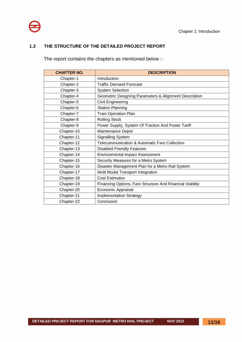
1.3 THE STRUCTURE OF THE DETAILED PROJECT REPORT
The report contains the chapters as mentioned below :-
CHAPTER NO. DESCRIPTION Chapter-1 Introduction Chapter-2 Traffic Demand Forecast Chapter-3 System Selection Chapter-4 Geometric Designing Parameters & Alignment Description Chapter-5 Civil Engineering Chapter-6 Station Planning Chapter-7 Train Operation Plan Chapter-8 Rolling Stock Chapter-9 Power Supply, System Of Traction And Power Tariff Chapter-10 Maintenance Depot Chapter-11 Signalling System Chapter-12 Telecommunication & Automatic Fare Collection Chapter-13 Disabled Friendly Features Chapter-14 Environmental Impact Assessment Chapter-15 Security Measures for a Metro System Chapter-16 Disaster Management Plan for a Metro Rail System Chapter-17 Multi Modal Transport Integration Chapter-18 Cost Estimates Chapter-19 Financing Options, Fare Structure And Financial Viability Chapter-20 Economic Appraisal Chapter-21 Implementation Strategy Chapter-22 Conclusion
Chapter 1: Introduction
DETAILED PROJECT REPORT FOR NAGPUR METRO RAIL PROJECT NOV 2013
12/16
Fig : 1.1 Index Plan of the Proposed Nagpur Metro Rail
Chapter 1: Introduction
DETAILED PROJECT REPORT FOR NAGPUR METRO RAIL PROJECT NOV 2013
13/16
Fig :1.2 Alignment-1 of MRTS Corridors Proposed by L&T-Ramboll Consulting Engineers Limited
Chapter 1: Introduction
DETAILED PROJECT REPORT FOR NAGPUR METRO RAIL PROJECT NOV 2013
14/16
Fig :1.3 Alignment-2 of MRTS Corridors Proposed by L&T-Ramboll Consulting Engineers Limited
Chapter 1: Introduction
DETAILED PROJECT REPORT FOR NAGPUR METRO RAIL PROJECT NOV 2013
15/16
Fig :1.4 Alignment-3 of MRTS Corridors Proposed by L&T-Ramboll Consulting Engineers Limited
Chapter 1: Introduction
DETAILED PROJECT REPORT FOR NAGPUR METRO RAIL PROJECT NOV 2013
16/16
Fig :1.5 Alignment-4 of MRTS Corridors Proposed by L&T-Ramboll Consulting Engineers Limited