introduction of the quasi-zenith satellite system (qzss) · 2010-02-15 · 1 satoshi kogure japan...
TRANSCRIPT
1
Satoshi KOGUREJapan Aerospace Exploration Agency
UN COPUOS STSCFebruary 15, 2010@Vienna
Introduction of the Introduction of the QuasiQuasi--Zenith Satellite Zenith Satellite
System (QZSS)System (QZSS)

2
Topics
Overviews of the QZSSDevelopment StatusMulti-GNSS Demonstration CampaignAsia Oceania Regional Workshop on GNSS

3
Quasi‐Zenith Satellite SystemThe QZSSThe QZSS
is a regional space-based PNT (Positioning, Navigation and Timing) systemcovers East Asia and Oceania region and transmits six civil PNT signals;
L1C/A, L1C on 1575.42 MHz, L2C on 1227.60 MHz and L5 on 1176.45 MHz L1-SAIF on 1575.42 MHz LEX on 1278.75MHz
can provide seamless PNT services by combining usage with GPS.
Increasing coverage and availability of PNT services even in downtown and mountainous areas.
can enhance GPS performance by transmitting error correction and integrity information.can accelerate the Modernization of GPS in Asia Oceania region.can be a suitable platform for Multi-GNSS augmentation.
First satellite will be launched in 2010. The 2nd and 3rd satellite will be approved after assessment of the technical demonstration result.

4
0 30 60 90 120 150 180 210 240 270 300 330 360-90
-60
-30
0
30
60
90
Longitude (deg)
Latitu
de (
deg
)
Minimum Elevation Angle and Ground Track
10
10
1010
10
102020
20
2020
20
30
30
30
30
30
40
40
40
40
50
50
50
50
50
60
60
60
60
70
GPS Elevation Angle Profile@Sydney
0
10
20
30
40
50
60
70
80
90
0 3 6 9 12 15 18 21 24
Simulation Time (hrs)
Ele
vation A
ngl
e (deg)
QZS-1
QZS-2
QZS-3
GPS
60
30
10
EW
N
S
G PS Elevation Angle Profile@ Tokyo
0
10
20
30
40
50
60
70
80
90
0 3 6 9 12 15 18 21 24
Sim ulation Tim e (hrs)
Elevation Angle (deg)
Q ZS-1Q ZS-2
Q ZS-3G PS
60
30
10
EW
N
S
@Sydney
@Tokyo
Azimuth Elevation plot & Elevation Angle Variation
Ground Track of a QZSS Satellite
At least one QZSS satellite can be observed more than specified elevation angle any time. For instance, users in orange colored area can receive at least one QZSS satellite with 70 degrees or more.
QZSS coverage and Visibility in Asia & Oceania
Quasi‐Zenith Satellite System
@Manila
60
30
10
EW
N
S
GPS Elevation Angle Profile@Manila
0
10
20
30
40
50
60
70
80
90
0 3 6 9 12 15 18 21 24
Simulation Time (hrs)
Ele
vation A
ngl
e (
deg)
QZS-1QZS-2QZS-3GPS

5
Quasi‐Zenith Satellite SystemCoverage
0 1 2 3
Average visible satellite number for QZSS (3 SV constellation)
Southeast Asia can observe 3 QZSS satellites almost of time.
Most East Asia and Oceania countries can observe more than 2 QZSS satellites every time

6
How QZSS works (1/3) GNSS application needs more than four ranging measurements between Satellites and User receiver
Computation X, Y, Z and TimeSometime, not easy to get four measurements
In urban canyon, deep forest, mountainous terrain and etc.
QZSS improves availability and coverage of GNSS.Current: Less than four measurements After QZSS: more than four
GPS
QZSS

7
How QZSS works (2/3) GNSS accuracy is modeled User Positioning Error= DOP (Dilution of Precision)DOP (Dilution of Precision) X URE (User Range Error)DOP is geometry among satellites and user.
DOP
Pos
ition
ing
Err
or
Bad Vertical DOP Bad Horizontal DOP
Large error

8
How QZSS works (2/3) GNSS accuracy is modeled User Positioning Error= DOP (Dilution of Precision)DOP (Dilution of Precision) X URE (User Range Error)DOP is geometry among satellites and user.
DOP
Pos
ition
ing
Err
or
Better Vertical DOP Better Horizontal DOP
Improve Improve useruser positioning errorpositioning error

9
How QZSS works (3/3) User Positioning Error
= DOP (Dilution of Precision) X URE (User Range Error)URE (User Range Error)There are several error correction methods to improve URE.QZSS will transmit
L1-SAIF SBAS type WDGPS correction*Experimental Signal (LEX)
NW-RTK for single frequency static survey use** Fresh and precise orbit and clock for PPP experiment
Orbit CorrectionOrbit Correction
TroposphereTroposphere
IonosphereIonosphere IonosphericIonospheric CorrectionCorrection
TroposphericTropospheric CorrectionCorrection
Clock CorrectionClock Correction
•• Same contribution to any user Same contribution to any user location;location;
•• Not a function of location;Not a function of location;•• Needs fast correction. Needs fast correction.
•• Different contribution to different user location;Different contribution to different user location;•• Not a function of user location; but a function of Not a function of user location; but a function of
lineline--ofof--sight direction;sight direction;•• LongLong--term correction.term correction.
•• Function of user location;Function of user location;•• Up to 100 meters;Up to 100 meters;•• Vertical structure may be Vertical structure may be
described as a thin shell.described as a thin shell.
•• Function of user location, especially height of user;Function of user location, especially height of user;•• Up to 20 meters;Up to 20 meters;•• Can be corrected enough by a fixed model.Can be corrected enough by a fixed model.
* developed by Electronic Navigation Research Institute (ENRI). ** developed by Geographical Survey Institute (GSI)
Courtesy of Dr. Sakai, ENRI

10
Enhancement GPS Capability
-90
-60
-30
0
30
60
90
0 30 60 90 120 150 180 210 240 270 300 330 360
-90
-60
-30
0
30
60
90
0 30 60 90 120 150 180 210 240 270 300 330 360
-90
-60
-30
0
30
60
90
0 30 60 90 120 150 180 210 240 270 300 330 360
-90
-60
-30
0
30
60
90
0 30 60 90 120 150 180 210 240 270 300 330 360
GPS only GPS+QZSS
3D Simulation Result at Tokyo Downtown Area: Positioning Availability (Time percentage of more than four satellites are visible)
Legend. ■0-20, ■20-40, ■40-60, ■60-80,■80-90■90-100 %
+QZSS+QZSS
Improvement of GPS Coverage and Performance
Legend. ■0-20, ■20-40, ■40-60, ■60-80,■80-90■90-100 %
+QZSS+QZSS
Global Distribution of PDOP Availability (Time percentage that PDOP is less than six with mask angle 30 degrees)

11
The Signal-in-Space (SIS) User Range Erroris less than 1.6 m (95%) Including time and coordination offset error.
User positioning Accuracydefine as positioning accuracy combined GPS L1_C/A and QZSS L1_C/A for single frequency user, L1-L2 for dual frequency user.
L1-SAIF signal can provide WDGPS correction data, its positioning accuracy is 1m (1 sigma rms) except in cases of large multipath error and large ionospheric disturbance.
Specification Simulation result
SIS-URE 1.6m (95%) 1.5m (95%)
Single frequency user 21.9m(95%) 7.02m(95%)
Dual frequency user 7.5m (95%) 6.11m(95%)
Expected Performance Expected Performance ‐‐ Accuracy Accuracy ‐‐

12
Standalone GPSStandalone GPSL1L1--SAIF AugmentationSAIF Augmentation
HorizontalHorizontalErrorError
VerticalVerticalErrorError
1.45 m1.45 m 2.92 m2.92 m
6.02 m6.02 m 8.45 m8.45 m
SystemSystem
StandaloneStandaloneGPSGPS
0.29 m0.29 m 0.39 m0.39 m
1.56 m1.56 m 2.57 m2.57 mL1L1--SAIFSAIF
RMSRMS
MaxMax
RMSRMS
MaxMax
L1-SAIF AugmentationExample of user positioning error at Example of user positioning error at TakayamaTakayama was simulated by ENRI.was simulated by ENRI.
MSASMSAS--like 6 monitor stations;like 6 monitor stations;Period: 19Period: 19--23 Jan. 2008 (5 days).23 Jan. 2008 (5 days).
Experimental Area for L1-SAIF
Enhancement GPS Capability
Courtesy of Dr. Sakai, ENRI

13
Carrier Phase PositioningBy using Carrier Phase Positioning, we can obtain
mmmm accuracy for science applications by offline analysiscm cm -- dmdm accuracy for real time applications
Technical trend of real time carrier phase positioningRTK
Relative positioning, need reference point Less than 10 km away from ref. point.Two receivers and communications radio link
NW-RTKRelative positioning, need local reference point networkLess than 100 km in the ref. point networkOne receiver and communications radio link
PPP (Precise Point Positioning) or SPP (Single Point Positioning)Absolute positioning, need global monitoring networkIndependent with ref. pointPrecise and fresh satellite orbit and clock is requested.Multi-GNSS use can facilitate to apply PPP techniqueOne receiver
The experiment using QZSS LEX signal is to be carried out

14 14
TVT (10/1/2009-10/30/2009)
ProtoProto--flight Tests are on goingflight Tests are on going
Preparation for TVT
@@MELCOMELCO
Development Status Development Status -- Space Segment Space Segment --
IPT(8/20/2009-9/3/2009) Initial Alignment Test(9/5/2009-9/10/2009)
Electrical Performance Test (11/21/2009-11/22/2009) Alignment Test after TVT
(11/23/2009-11/25/2009)
Sine Vibration Test(7/12/2009-6/1/2010)

15
QZS-1Muster Control Station(MCS)@Tsukuba Space Center (TKSC),
Completed installation of computer system at the site. Preparing Integration Test for whole systems.
Monitor Station (MS)Koganei, Okinawa, Sarobetsu, and Guam:
Installation of equipment at the site and Network connection were completed
Ogasawara, Hawaii, Bangkok, Bangalore, CanberraPreparing for installation
Tracking & Control SystemNew C-band Antennas has been constructed at Okinawa Space
Communications Station.Integration test between remote control system located in TKSC
are being conducted.
Development Status Development Status ‐‐ Ground Segment Ground Segment ‐‐
MS equipment(Guam)
Operation room in MCS(TKSC)
MCS/TTC equipment(TkSC)
TTC & NAV message Uplink Station (Okinawa)

16
Asia Oceania is the Showcase of Asia Oceania is the Showcase of New GNSS Era New GNSS Era
Multi-GNSSMore Stars, Signals
Multi-Frequency
10 15 20 25 30 35
GPSGLONASSGalileoCOMPASSIRNSSQZSSAnd more….
Higher accuracyMore reliable, robustIncrease coverage, availability
New Applications
Visible Satellite Number (mask angle 30 deg)
GPS+GLONASS+Galileo+COMPASS+IRNSS+QZSS

17
Asia Oceania MultiAsia Oceania Multi‐‐GNSS GNSS Demonstration Campaign Demonstration Campaign
Aiming toPromote new multi-GNSS utilization and applications in the region and feedback needs and requirements related to interoperability from user communities to GNSS providersEncourage GNSS provider and users in Asia Oceania region to develop new applications and carry out experiment or demonstration jointly.
To be Implemented a series of activities for five years from 2010, including;
1. Establishment of Multi-GNSS Monitoring Network• International collaboration with IGS and related organizations
2. Development of multi GNSS applications and demonstrations3. Annual Regional Work Shop

18
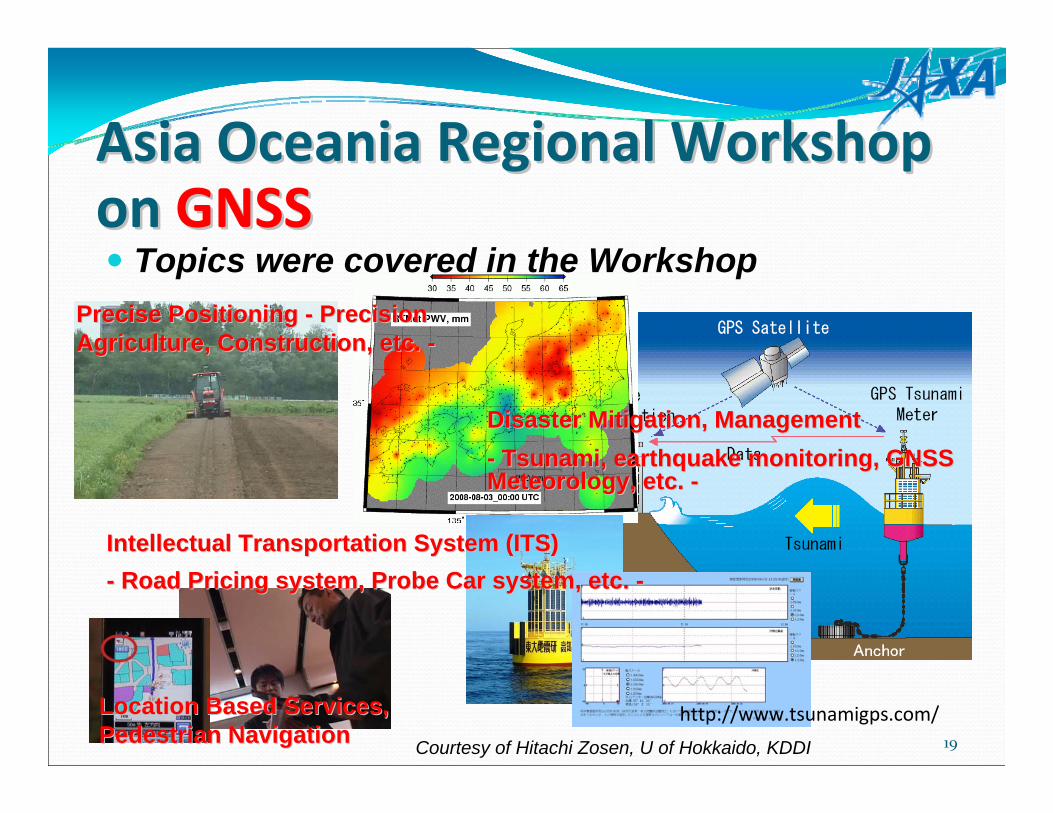
Asia Oceania Regional Asia Oceania Regional Workshop on Workshop on GNSSGNSS
held in Bangkok, Thailand on January 25-26, 2010 followed by APRSAF16 to discuss future joint development and experiment for multi GNSS use in Asia Oceania regionHosted by SPAC*, JAXA, and GISTDA** of Thailand and supported byUN International Committee on GNSS (ICG)195 participants from 18 countriesThe detail information is to be available on;http://http://www.multignss.asiawww.multignss.asia//
*SPAC: Satellite Positioning Applications Center ** GISTDA: Geo-Informatics and Space Technology Agency
19
Asia Oceania Regional Workshop Asia Oceania Regional Workshop on on GNSSGNSS
http://www.tsunamigps.com/
Courtesy of Hitachi Zosen, U of Hokkaido, KDDI
Topics were covered in the WorkshopPrecise Positioning Precise Positioning -- Precision Precision Agriculture, Construction, etc. Agriculture, Construction, etc. --
Location Based Services, Location Based Services, Pedestrian NavigationPedestrian Navigation
Disaster Mitigation, ManagementDisaster Mitigation, Management-- Tsunami, earthquake monitoring, GNSS Tsunami, earthquake monitoring, GNSS Meteorology, etc. Meteorology, etc. --
IntellectualIntellectual Transportation System (ITS)Transportation System (ITS)-- Road Pricing system, Probe Car system, etc. Road Pricing system, Probe Car system, etc. --

20
SummaryThe QZSSThe QZSS
is a regional space-based PNT (Positioning, Navigation and Timing) system being developed step-by-step approach. The first satellite will be launched in 2010.covers East Asia and Oceania region. can provide seamless PNT services by combining usage with GPS.
Increasing coverage and availability of PNT services even in downtown and mountainous areas.
can enhance GPS performance by transmitting error correction andintegrity information.can accelerate the Modernization of GPS in Asia Oceania region.can be a suitable platform for Multi-GNSS augmentation.
The 1st Asia Oceania Regional Workshop on GNSSwas held in Bangkok on 25-26 January, 2010 to discuss future joint development and experiment for multi GNSS usage in Asia Oceania region as an activity of Asia Oceania Multi-GNSS Demonstration Campaign

21
Thanks a lot for your attention!
Contact;Satoshi Satoshi KogureKogure
Associate Senior EngineerJapan Aerospace Exploration Agency (JAXA)QZSS project team/Space Applications and Promotion Center2-1-1 Sengen, Tsukuba, Ibaraki, 305-8505, JapanTel: +81-50-3362-2456Fax: +81-29-868-5987E-mail: [email protected]