introduction - pvpc | pioneer valley … · web viewrja realty holdings, inc. low hazard 10/20/2005...
TRANSCRIPT
DRAFT Winter 2016
THE TOWN OF MONSON
LOCAL NATURAL HAZARDS MITIGATION PLAN UPDATE
Adopted by the Monson Board of Selectmen on __________
Prepared by:
The Monson Natural Hazards Mitigation Planning Committee
With technical assistance provided by the Pioneer Valley Panning Commission with funding received from the Federal Emergency Management Agency (FEMA) via the Massachusetts Emergency Management
Agency (MEMA)

ACKNOWLEDGEMENTS
The Monson Board of Selectmen extends special thanks to the Monson Natural Hazards Mitigation Planning Committee:
Evan Brassard, Town AdministratorDan Laroche, Town PlannerJohn Morrell, Highway Surveyor/Tree WardenSteve Kozloski, Chief of PoliceLarent R. McDonald, Fire Chief
The Monson Board of Selectmen also thanks the Massachusetts Emergency Management Agency (MEMA) for developing the Commonwealth of Massachusetts Natural Hazards Mitigation Plan (http://www.state.ma.us/dem/programs/mitigate/index.htm) which served as a model for this plan update.

Table of Contents
1: PLANNING PROCESS............................................................................................................1Introduction.......................................................................................................................1Hazard Mitigation Workgroup...........................................................................................1Participation by Public and Neighboring Communities......................................................3Select Board Meeting.........................................................................................................3
2: LOCAL PROFILE....................................................................................................................4Community Setting.............................................................................................................4Infrastructure.....................................................................................................................4Natural Resources..............................................................................................................7Development....................................................................................................................11
3: HAZARD IDENTIFICATION & Risk Assessment......................................................................1Natural Hazard Analysis Methodology...............................................................................1Floods.................................................................................................................................5Severe Snowstorms and Ice Storms.................................................................................11Hurricanes........................................................................................................................15Severe Thunderstorms / Wind / Tornadoes.....................................................................19Wildfire / Brushfire.......................................................................................................... 23Earthquakes..................................................................................................................... 27Dam Failures.................................................................................................................... 31Drought............................................................................................................................38Extreme Temperatures....................................................................................................41Other Hazards..................................................................................................................44
4: CRITICAL FACILITIES............................................................................................................45Facility Classification........................................................................................................45Category 1 – Emergency Response Services....................................................................46Category 2 – Non Emergency Response Facilities............................................................47Category 3 – Facilities/Populations to Protect.................................................................48Category 4 – Potential Resources.....................................................................................50
5: Current MITIGATION STRATEGIES......................................................................................52Overview of Mitigation Capabilities by Hazard................................................................53Existing Mitigation Capabilities and Strategies.................................................................59Deleted or Completed Mitigation Strategies....................................................................62Previously Identified and New Strategies.........................................................................64Prioritized Implementation Plan......................................................................................64Prioritization Methodology..............................................................................................64Cost Estimates..................................................................................................................65Project Timeframe........................................................................................................... 66
6: PLAN ADOPTION & IMPLEMENTATION..............................................................................70

7: APPENDICES.......................................................................................................................73Appendix A – Technical Resources...................................................................................73Appendix B – Documentation of the Planning Process....................................................77Appendix C – List of Acronyms.........................................................................................79Appendix D – Past & Potential Hazards/Critical Facilities Map........................................80Appendix E – Development Regulations and Policies for Mitigating Hazards in Monson 81Flooding........................................................................................................................... 81Severe Snowstorms/Ice Storms.......................................................................................95Hurricanes & Tropical Storms...........................................................................................96Tornadoes........................................................................................................................ 98Wildfires/Brushfires.......................................................................................................100Earthquakes................................................................................................................... 100Dam Failures.................................................................................................................. 102
1: PLANNING PROCESS
Introduction
The Federal Emergency Management Agency (FEMA) and the Massachusetts Emergency Management Agency (MEMA) define natural hazard mitigation as any sustained action taken to reduce or eliminate long-term risk to people and property from natural hazards such as flooding, storms, high winds, hurricanes, wildfires, earthquakes, and similar occurrences. Mitigation efforts undertaken by communities help minimize damages to public buildings and infrastructure, such as water supplies, sewers and utility transmission lines, as well as private property and natural, cultural and historic resources.
Pre-disaster mitigation planning, including this effort by the Town of Monson and the Pioneer Valley Planning Commission, is a proactive process. Pre-disaster planning emphasizes actions that can be taken before a natural disaster occurs. Future property damage and loss of life can be reduced or prevented by a mitigation program that adequately addresses the unique geography, demography, economy, and land use of a community within the context of each of the specific potential natural hazards that may threaten a community.
Preparing a local natural hazards mitigation plan before a disaster happens can save the community money and will facilitate post-disaster funding. Costly repairs or replacement of buildings and infrastructure, as well as the high cost of providing emergency services and rescue/recovery operations, can be avoided or significantly lessened if a community implements the mitigation measures detailed in the Plan. FEMA requires that a community adopt a pre-disaster mitigation plan as a condition for mitigation funding. For example, the Hazard Mitigation Grant Program (HMGP), the Flood Mitigation Assistance Program (FMA), and the Pre-Disaster Mitigation Program are programs with this requirement.
Hazard Mitigation Workgroup
In 2015, the Town of Monson completed an update of their 2007 Hazard Mitigation Plan, in collaboration with the Pioneer Valley Planning Commission. All portions of the plan were reviewed and updated as necessary. Planning for hazard mitigation in Monson involved a five-member workgroup:
Evan Brassard, Town Administrator
Dan Laroche, Town Planner
John Morrell, Highway Surveyor/Tree Warden
Steve Kozloski, Chief of Police
Larent R. McDonald, Fire Chief
The hazard mitigation planning process for the Town included the following tasks:
Town of Monson– Local Natural Hazards Mitigation Plan Update 1
Reviewing and incorporating existing plans and other information.
Identifying the natural hazards that may impact the community.
Conducting a Vulnerability/Risk Assessment to identify the infrastructure at the highest risk for being damaged by the identified natural hazards, particularly flooding.
Identifying and assessing the policies, programs, and regulations the community is currently implementing to protect against future disaster damages.
Identifying deficiencies in the current strategies and establishing goals for updating, revising or adopting new strategies.
Adopting and implementing the final Hazard Mitigation Plan.
The key product of this process is the development of an Action Plan with a Prioritized Implementation Schedule.
Workgroup Meetings
Meetings of the Hazard Mitigation Planning Committee, all of which took place at Town Hall, were held on the dates listed below. Agendas for each meeting are included in Appendix B.
September 16, 2016Review of Hazard Mitigation Planning process, Planning Process chapter, Local Profile chapter, hazard identification analysis.
September 30, 2015Review of critical facilities and infrastructure map, current mitigation strategies and the status of each strategy, evaluated effectiveness of current strategies, and determined potential changes to current mitigation strategies.
October 15, 2015Discussion of new proposed mitigation strategies for addressing hazards, including estimating the cost of each strategy, the responsible entity, a timeline for completion, and the priority of each strategy.
December 9, 2015Continued discussion of new mitigation strategies, and discussion of process for adoption and maintenance of the plan, procedures for routine updates, and a review of the overall plan and all sections.
Agendas and sign-in sheets for each meeting can be found in Appendix B. While not all members of the Hazard Mitigation Committee were able to attend each meeting, all members collaborated on the plan and were updated on progress by fellow Committee members after meetings occurred as necessary.
Town of Monson– Local Natural Hazards Mitigation Plan Update 2

Participation by Public and Neighboring Communities
Two public planning sessions were held as part of the development of the plan – on October 22, 2015, and December 9, 2015. Both meetings occurred after the Hazard Mitigation Workgroup had provided input on hazards and mitigation strategies relevant to the community. Notice of both public meetings was posted at Town Hall in compliance with the Commonwealth of Massachusetts’ open meeting law. Public meeting agendas and notices can be found in Appendix B.
On _________, the Town issued a press release to all area media outlets to inform the public that a draft of the Monson Hazard Mitigation Plan had had been placed on the Town website. The release also indicated that hard copies were available at Town Hall and that all residents, businesses and other concerned parties of Monson and adjacent communities were encouraged to comment on the plan.
Citizens from adjacent municipalities were encouraged to comment on Monson’s plan.
The press release and a screen shot of Monson’s website showing the link to the press release can be found in Appendix B.
Public participation will be a critical component of the Hazard Mitigation Plan maintenance process. The Hazard Mitigation Committee will hold all meetings in accordance with Massachusetts open meeting laws.
Select Board Meeting
In 2013, the Select Board agreed to begin the process of updating the Town’s Hazard Mitigation Plan. Once the plan was provisionally approved by FEMA, the Select Board held a public hearing on the plan and adopted it on ______.
Town of Monson– Local Natural Hazards Mitigation Plan Update 3

2: LOCAL PROFILE
Community Setting
Monson is a rapidly-growing semi-rural community located in Hampden County in south-central Massachusetts. Monson’s historic downtown—a local center for business, government, and civic life—is nestled in the valley of Chicopee Brook and surrounded by steep and rugged hills covered by forest and farms. The Town’s total land area is approximately 28,800 acres, or 45 square miles, making it one of the larger towns in Massachusetts.
Monson was originally a part of Brimfield until 1775, when it was incorporated as a separate town. The Town began as a farming and lumbering community, but evolved into an industrial town early in the 18 th
century, when water power from Chicopee Brook and a transportation system based on the railroad, fueled a thriving textile industry. In the past few decades, the Town’s industrial base has declined, and farming and lumbering have become more limited. At the same time, Monson has become a desirable location for new residences, especially for commuters, and portions of the Town have become more suburban in character as new development has spread out along existing public roads.
Monson is bordered by Palmer to the north, Brimfield and Wales to the east, Wilbraham and Hampden to the west and Stafford, Connecticut, to the south. Monson is 17 miles east of Springfield, 40 miles west of Worcester, 77 miles southwest of Boston and about 157 miles from New York City. The Town is within close proximity to the Massachusetts Turnpike and I-84, which offer quick and convenient access to Springfield, Hartford, and eastern Massachusetts. The New England Central Railroad runs in a north-south direction through the Town, connecting New Haven, Connecticut to Burlington, Vermont. Amtrak service is provided on this rail line, but there is no passenger service to Monson.
Since 1980, Monson’s population has grown at an average rate of about 7% per decade, which translates on average to about 60 new persons per year. Over the past several years, which included the Great Recession starting in 2008, an average of about 10 new single-family houses have been constructed each year.
Infrastructure
Monson’s geography has been a major factor in the development of its infrastructure. Rounded hill tops surrounded by large wetland systems have helped to shape and guide local land use patterns as well as limit the value that existing and potential infrastructure might offer towards the expansion of development beyond those lots with frontage on the main roadways in town.
Roads and Highways
Monson has approximately 106 miles of Town maintained ways including 97 miles of paved roads and 9 miles of gravel roads. In addition, approximately four miles of private ways exist in the Town. Most of the private ways were constructed prior to the adoption of Monson’s Subdivision Regulations. Overlook Drive is the only private way constructed under subdivision control. All of Route 20 and portions of
Town of Monson– Local Natural Hazards Mitigation Plan Update 4

Route 32 are maintained by the state through the Massachusetts Highway Department. A 1.6 mile portion of Main Street (Route 32) located in the town center is town-owned and town-maintained. The majority of maintenance work conducted on public ways is funded through federal and state programs. The Massachusetts Legislature appropriates funds known as Chapter 90 funds to communities on a yearly basis for the repair and maintenance of public ways. The level of funding is derived from a formula based on the number of miles of public ways, employment figures, and town population. The level of funding through this program has decreased steadily over the past few years. In Monson, these funds are the primary source of funding for road maintenance and repair work. The Town has also utilized Community Development Block Grant funds for road and sidewalk improvements in the town center.
Approximately 13 miles of sidewalks exist in Monson (mainly in the town center). Few sidewalks exist in the rural residential areas of Town. These sidewalks are in fair to poor condition. The Town allocates $2,000 per year for sidewalk improvements. In addition, if the Town reconstructs a road or conducts major road repairs, the sidewalks are repaired at the same time.
Rail
The New England Central Railroad runs through Monson, and the CSX track threads Monson’s Northern border.
Public Transportation
Monson is not a member of a Regional Transit Authority and, therefore, does not have any public transportation options available to its citizens.
Public Drinking Water Supply
Approximately 56 percent of the Town’s residents obtain their drinking water from individual private wells. The remaining 44 percent receive water through the Town’s municipal water system, which relies on three groundwater wells: the Bunyan Road, the Palmer Road, and the Bethany Road wells. These three sources are located along Chicopee Brook. The water system has one water storage tank with a capacity of 1,000,000 gallons and the distribution system consists of about 36 miles of pipe. The majority of the distribution system consists of unlined cast iron pipe that is 100 years old in some places. According to the Water Supply, Distribution and Storage Study prepared in 1998 by the Board of Water Commissioners with Tighe & Bond, the Town provides water to about 44% of the population. The remaining residents obtain their water from individual on-site wells.
The Bunyan Road well is the primary water supply source for the Town. The well has a safe yield of 800 gallons per minute (gpm). The pump in this well originally had a capacity of 900 gpm, but there has been a considerable decrease in the production of the well over the years due to the accumulation of mineral solids. In 1998, the well was producing about 510 gpm. Due to the natural acidic nature of the groundwater, a corrosion control system has been installed at the Bunyan Road well. The Palmer Road well and the Bethany Road well are used on a limited basis due to the absence of a corrosion control system and to minimize utility demand and power costs.
Between 1992 and 2001, the Bunyan Road well has supplied, on average, 97% of the total water supplied to the system, the Palmer Road well has accounted for an average of 2.75% and the Bethany
Town of Monson– Local Natural Hazards Mitigation Plan Update 5

Road well has made up the remaining 0.25%. From 2002 to the present, the Bunyan Road well is supplying 0%, Palmer Road 98%, and Bethany 2%.
The maximum daily water demand in 2000 was estimated to be approximately 1.15 million gallons per day (mgd). The projected maximum daily demand is expected to increase to 1.37 mgd by the year 2020; however, it should be noted that future projections are difficult to make because a single large industrial water user could account for at least as much new demand as all new residential development over the next 20 years. Residential water usage from Monson’s public water supply has actually dropped in recent years, most likely the result of a decrease in water usage at the Monson Developmental Center. The current available municipal supply sources have sufficient safe yield to meet the current and projected maximum day demands, assuming that all well sources are functional. Typical water works practice for supply planning is to analyze the system with one major supply off-line. If the Bunyan Road well is off-line for maintenance purposes, the Town must use the Palmer Road well and the Bethany Road well. The combined yields from these two wells can comfortably meet the 2020 maximum day demand of 1.27 mgd. However, because neither of these sources is equipped with treatment systems for corrosion control, the Town could potentially be in violation of the Lead and Copper Rule of the Safe Drinking Water Act if the Bunyan Road well is off-line for extended periods.
Water storage facilities provide additional water supply to meet peak demands during well shutdowns, drought conditions, or fire emergencies. There is no infrastructure in place to turn to surface water supplies. The Town has a single one million gallon storage tank located on Ely Road. According to the 1998 Tighe & Bond report, the existing storage tank does not have sufficient water storage capacity to meet the Town’s current needs. An additional 1.1 million gallons of storage capacity will be needed to meet the Town’s projected 2020 water storage needs. Specifically, consideration should be give to the installation of a 1.1 million-gallon storage tank on Brimfield Road and the installation of a 0.5 million-gallon storage tank on Bald Peak Road, which would provide system flexibility by facilitating a future connection to the Palmer water system.
Sewer Service
The Town’s sewer system is approximately 20 years old. The sewer system generally follows the location of the municipal water system with the exception of the Paradise Lake area, which has public sewerage but not public water. The system includes one pump station located on Hospital Road. The Town’s wastewater is not treated in Monson but is transferred to the Palmer wastewater system for treatment and disposal. The Town is currently not considering any significant sewer system expansions.
Stormwater
There are areas within the downtown with undersized stormwater drainage lines. As development continues and the amount of impervious (paved and building) surface increases, improvements to these systems will be needed. In addition, there are 1,100 catch basins located throughout the Town. The Department of Public Work uses an outside contractor to clean approximately 200 basins a year. Due to location and siltation rates, many of the same basins are cleaned each year but some catch basins are not cleaned for years. Lack of maintenance can lead to flooding, environmental problems, and the need for expensive repairs.
Town of Monson– Local Natural Hazards Mitigation Plan Update 6
Dams
There are 26 dams in Monson, 9 of which are rated by the Office of Dam Safety as High or Significant Hazards. A High Hazard rating means the dam is “located where failure will likely cause loss of life and serious damage to home(s), industrial, commercial facilities, important public utilities, main highway(s) or Railroad(s).” A Significant Hazard rating means the dam is “Located where failure may cause loss of life and damage home(s), industrial or commercial facilities, secondary highway(s) or railroad(s) or cause interruption of use or service of relatively important facilities.”
Schools
Public schools serving Monson include the Monson High School, Granite Valley Middle School, and Quarry Hill Community School.
Economic Districts / Industrial Areas
Most of the economic and industrial activity in Monson is located along Route 32 and Chicopee Brook. Some of this economic and industrial activity is located in flood plains. Industry in this area is reliant on natural gas service.
Natural Resources
Monson’s existing natural and historic resources play a major role in defining the community’s identity. The Town’s forests, streams, valleys, and wildlife define its rural, natural setting, while historic buildings in the downtown and elsewhere impart a timeless charm on the community. This section describes Monson’s natural and historic resources and evaluates the status of their protection based on information from previous studies, MassGIS, the Massachusetts Natural Heritage and Endangered Species Program, and the Massachusetts Historical Commission.
Geology
Monson consists of a north/south oriented Y-shaped valley nestled between two prominent ridge lines. The western ridge and hills are granite intrusions that were formed several hundred million years ago by a bubble of molten rock that pushed its way to the surface but did not break through. As these igneous intrusions cooled, they formed the granite hills that separate Monson from Wilbraham. Monson’s highest peaks, such as Peaked Mountain (1,278 feet), West Hill (900 feet), and Chicopee Mountain (800 feet) are found along the western ridgeline. At the base of these formations, Monson Granite was quarried for use in many of the Town’s now historic buildings. The east ridgeline, in contrast, was formed from glacial deposits composed of granite, sandstone, feldspar, and quartz. These formations were created when the glaciers retreated several thousand years ago and dropped debris gathered from distant landscapes.
Monson’s historical development pattern has been affected by its geological and soil characteristics. The eastern ridge was settled first in part because of its loose stone glacial deposits. This loose subsurface
Town of Monson– Local Natural Hazards Mitigation Plan Update 7

made it easier to develop, drill wells, and to till the land. Vegetation was also much more abundant on this eastern ridge because of the loose composition of the soil. Small, family-owned farms still exist on the ridge along East Hill Road to the north, and on Moulton Hill Road to the south. In contrast, the western ridge was more suitable for lumbering and less suitable for farming, due to steep slopes. Development of this ridge is much more recent, and has in some instances occurred along unpaved lumber roads.
Water Resources
Monson’s plentiful water resources include numerous rivers and streams, extensive wetlands, and ponds. Currently the town does not rely on surface water for it drinking water supply.
Rivers and Streams
Monson lies within portions of three watersheds. The largest of these watershed areas is the Chicopee River watershed, which occupies approximately 77% (21,940 acres) of the Town. The Chicopee River watershed includes most of the Town’s significant ponds, wetlands, and aquifers. The other watershed areas within Monson include the Connecticut River watershed (3,980 acres in Monson), and Quinnabog watershed (2,715 acres in Monson). These two watershed areas are located mainly in the southern part of the Town near the Connecticut state line.
Chicopee Brook is Monson’s largest stream, and flows north to the Quaboag River. In the past, Chicopee Brook powered many of Monson’s mills. The Quaboag River forms the northern boundary between Monson and Palmer. The quality of the Quaboag River has improved since the 1960s and 1970s, largely because of the abandonment of the industries and factories along the river. Compared to present standards, however, the water quality of the Quaboag is still a concern, and industry is still located upstream. Monson has approximately 133 acres of surface water.
The Town’s surface water includes many small ponds and lakes such as Pulpit Rock Lake and Paradise Lake, in addition to an intricate network of small streams that meander through the forests to the valley.
Wetlands
There are approximately 960 acres of forested and unforested wetlands in the Town.1 Wetlands are located throughout Monson’s landscape in areas of poorly-drained glacial till soils that are a heterogeneous mixture of clay, silt, sand and gravel deposited by glacial ice. This unsorted layer of glacial deposits has low water permeability and therefore retains moisture. The number of streams and brooks that flow into these poorly-drained areas is also a factor in the formation of wetlands. The Cedar Swamp in Monson’s southeast corner represents a unique wetland landscape feature. Cedar Swamp is owned by the Monson Conservation Commission.
The 166 acres of wetlands identified in includes only unforested wetlands bordering streams and ponds and occupying isolated pockets of land throughout the Town. An additional 800 or so acres of forested wetlands are included in the “forest” category.
Beaver Dams
Town of Monson– Local Natural Hazards Mitigation Plan Update 8

Beaver activity has been increasing over the past decade. Beaver dam activity is concentrated along Chicopee Brook, particularly Bunyan, Nieske, Hospital, and Reimers Roads, and Silver and Thayer Streets. These are also right-of-ways that experience flooding.
Several wetland areas have been flooded by beaver dam construction. As a result, their vegetation has changed from forested wetland to marshy habitat. Sometimes beaver activity is detrimental to property, causing problems for local land owners (e.g., flooding of wells, septic systems, lawns, out-buildings, and roadways). Affected individuals must contact the Board of Health and Conservation Commission for advice and permission to alleviate the beaver problem.
Cedar Swamp A 50-acre white cedar swamp is located off Cedar Swamp Road. The vegetation in the swamp includes maple, birch, azaleas, mountain laurel, fern, fringed gentian, and skunk cabbage. The area is suitable for nature study, and is open to the general public under the auspices of the Monson Conservation Commission. The western section of the swamp is suitable for wildlife habitat preservation and management for deer and hare. The wooded roads along the northwest side of the swamp are suitable for hiking and provide access to the woods for hunting and woodland management.
Aquifers Groundwater can exist in aquifers as well as the pores within rock formations. An aquifer is a geologic formation capable of yielding significant quantities of water. Aquifers are generally found in sand and gravel deposits where pores in the soil allow water to collect. Groundwater enters the aquifer through sand and gravel soils, wetlands, and surface water bodies, and slowly percolates through the ground in a down-gradient direction. Monson’s aquifers are located primarily along Chicopee Brook.
FloodwaysWater levels in Monson’ rivers, streams, and wetlands rise and fall seasonally and during high rainfall events. High water levels are typical in spring, due to snowmelt and ground thaw. This is the period when flood hazards are normally expected. Low water levels occur in summer due to high evaporation and plant uptake (transpiration). At any time, heavy rainfall may create conditions that raise water levels in rivers and streams above bank full stage, which then overflow adjacent lands.
Floodways include the watercourses (rivers and streams) and adjacent relatively low-lying areas subject to periodic flooding (the 100-year flood zone and 500-year flood zone). These adjoining lands are flood hazard zones and they vary in their predicted flood frequency. The 100-year flood zone has a one in 100 statistical probability (or one percent chance) of being flooded in a single year or is predicted to be flooded one year out of a 100-year period; while the 500-year flood zone is based on a 500-year period. Most of the floodways in Monson are narrow, fewer than 400 feet wide, because the town’s hilly topography and rocky terrain do not permit the formation of broad floodplains. Monson’s floodways are corridors that pass flowing water downstream, eventually into the Connecticut River.
The National Flood Insurance Program has produced maps that identify floodways across America. The following areas have been designated as floodways in Monson:
(1) Connant Brook(2) Chicopee Brook-through the center of town and north to the Quaboag River(3) Vinica Brook(4) Twelve Mile Brook and surrounding residential properties
Town of Monson– Local Natural Hazards Mitigation Plan Update 9

Forests
The vast majority of Monson is forested, which provides an abundance of timber, opportunities for recreation, wildlife habitat, the benefits of climate moderation, and the protection of water quality. The forest and intermixed agricultural land also provide a visually pleasant landscape for residents and visitors too. The town's forests are mainly closed-canopied and middle-aged, having a great diversity of species, but no diversity of horizontal or vertical structural. Interestingly, the town is eighty-five percent forested.
Large blocks of contiguous forestland such as those in Monson are important resources for several reasons. First they represent an area with a low degree of fragmentation. Wildlife species that require a certain amount of deep forest cover separate from people’s daily activities tend to migrate out of fragmenting landscapes. New frontage lots and subdivisions can often result in a widening of human activity, an increase in the populations of plants and animals that thrive alongside humans (i.e. raccoons and squirrels) and a reduction in the species that have larger home ranges and unique habitat needs. Large blocks of forest provide clean water, air, and healthy wildlife populations.
Forest covers almost 76% of the Town’s land area. As of 2014, approximately 58 privately owned parcels totaling approximately 1,500 acres are enrolled in the Chapter 61 tax abatement program, which means that they are actively managed for forestry.
Town of Monson– Local Natural Hazards Mitigation Plan Update 10

Development
Several factors have and continue to influence the development patterns of Monson. These include: existing development and the availability of land for new development; the existing road network; physical and topographic features, such as steep slopes, soil conditions, lakes, tributaries and floodplains; protection of land for conservation or agricultural use through conservation restrictions, the Massachusetts Agricultural Preservation Restriction (APR) program, deed restrictions and other measures; and the availability of utility services, especially public water and sanitary sewers.
Monson’s master plan, as well as its Zoning Bylaw and related land use regulations, constitute a “blueprint” for the town’s future. Land use patterns will continue to evolve, influenced and limited by local planning goals and regulations, as well as nature features and economic conditions. Eventually, Monson will be “built out”— there will be no more undeveloped (or unprotected) land left to build on. Therefore, it is critical to the natural hazard mitigation planning process focus not on current land uses and build-outs, but on the likely and potential future uses and build-outs that are allowed by regulations.
Current Development Trends
Monson’s population in 2014 was 8,660 residents, as estimated by the 2009-2014 American Community Survey. In 2000, there were 8,359 residents, indicating only modest growth (3.6%) over the past 15 years.
The majority of Monson’s 28,815 acres is undeveloped forest and water, totaling nearly 22,000 acres. Agricultural land totaling 2,493 acres, and residential land totaling 2,798 acres account for the majority of the remaining town area. Commercial and industrially used land consists of approximately 138 acres, with public/urban open land contributing an additional 889 acres.1
Currently, development in Monson is moderately encouraged by existing zoning regulations to locate in areas where the infrastructure and environmental conditions can best support growth. The town’s Zoning Bylaw limits development, primarily subdivisions, in areas that are preserved for agriculture and conservation, or in areas that are designated flood hazard zones. The closing of the Monson Development Center on Upper Palmer and Hospital Roads in 2012 means that approximately 600 acres are available for potential development in that area, which is partially located in a floodplain near the river.
1 Information gathered from the Monson Master Plan, based on 1999 aerial photographs for a “buildout analysis” conducted by the Pioneer Valley Planning Commission.
Town of Monson– Local Natural Hazards Mitigation Plan Update 11
Most of the new residential development is so-called “Approval-Not-Required” (M.G.L. Ch. 41 §81P) development of single houses along existing roadsides, which the Town has very limited authority to regulate. Population growth and dispersed development patterns over the decades have increased demand for public services and facilities such as schools and road maintenance. Most of the newly developed housing consists of relatively expensive single-family homes. Consistent with the Town’s 60,000 square foot minimum lot size for single-family homes in the Rural Residential District, almost all new residential development in Monson is low density. In 1985, each Monson resident occupied an average of 0.31 acres of land. However, since 1985, each new resident has occupied an average of 0.44 acres of land. There are very few residential subdivisions in the Town.
National Flood Insurance Program
The Town of Monson participates in the National Flood Insurance Program. As of 2015, there were 25 flood policies in effect in Monson for a total of $4,526,100 worth of insurance. The 2014 update of FEMA’s Flood Hazard Maps changed the 100 year floodplain of Chicopee Brook to impact an additional X properties ($X value). The town is not a member of the Community Rating System, which entitles policyholders to a discount on flood insurance premiums.
The Community Rating System reduces flood insurance premiums to reflect what a community does above and beyond the National Flood Insurance Program’s (NFIP) minimum standards for floodplain regulation. The objective of the CRS is to reward communities for what they are doing, as well as to provide an incentive for new flood protection activities. To participate in the CRS, a community must fill out an application and submit documentation that shows what it is doing and that its activities deserve at least 500 points. More information including instructions and applications is available at http://training.fema.gov/EMIWeb/CRS/m3s1main.htm.
Town of Monson– Local Natural Hazards Mitigation Plan Update 12

3: HAZARD IDENTIFICATION & RISK ASSESSMENT
The following section includes a summary of disasters that have affected or could affect Monson. Historical research, conversations with local officials and emergency management personnel, available hazard mapping and other weather-related databases were used to develop this list. Identified hazards are the following:
Floods Severe snowstorms / ice storms Hurricanes Severe thunderstorms / wind / tornadoes Wildfires / brushfires Earthquakes Dam failure Drought Extreme Temperatures
Natural Hazard Analysis Methodology
This chapter examines all hazards identified by the Massachusetts State Hazard Mitigation Plan. The analysis is organized into the following sections: Hazard Description, Location, Extent, Previous Occurrences, Probability of Future Events, Impact, and Vulnerability. A description of each of these analysis categories is provided below.
Hazard Description
The natural hazards identified for Monson are: floods, severe snowstorms/ice storms, hurricanes, severe thunderstorms / wind / tornadoes, wildfire/brushfire, earthquakes, dam failure, drought, and extreme temperatures. Many of these hazards result in similar impacts to a community. For example, hurricanes, tornadoes and severe snowstorms may cause wind-related damage.
Location
Location refers to the geographic areas within the planning area that are affected by the hazard. Some hazards affect the entire planning area universally, while others apply to a specific portion, such as a floodplain or area that is susceptible to wild fires. Classifications are based on the area that would potentially be affected by the hazard, on the following scale:
Town of Monson– Local Natural Hazards Mitigation Plan Update 1

Location of Occurrence, Percentage of Town Impacted by Given Natural Hazard
Location of Occurrence Percentage of Town Impacted
Large More than 50% of the town affected
Medium 10 to 50% of the town affected
Small Less than 10% of the town affected
Extent
Extent describes the strength or magnitude of a hazard. Where appropriate, extent is described using an established scientific scale or measurement system. Other descriptions of extent include water depth, wind speed, and duration.
Previous Occurrences
Previous hazard events that have occurred are described. Depending on the nature of the hazard, events listed may have occurred on a local, state-wide, or regional level.
Probability of Future Events
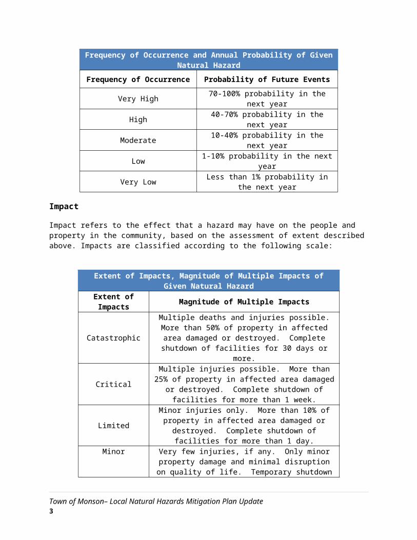
The likelihood of a future event for each natural hazard was classified according to the following scale:
Frequency of Occurrence and Annual Probability of Given Natural Hazard
Frequency of Occurrence Probability of Future Events
Very High 70-100% probability in the next year
High 40-70% probability in the next year
Moderate 10-40% probability in the next year
Low 1-10% probability in the next year
Very Low Less than 1% probability in the next year
Impact
Impact refers to the effect that a hazard may have on the people and property in the community, based on the assessment of extent described above. Impacts are classified according to the following scale:
Extent of Impacts, Magnitude of Multiple Impacts of Given Natural Hazard
Town of Monson– Local Natural Hazards Mitigation Plan Update 2

Extent of Impacts Magnitude of Multiple Impacts
CatastrophicMultiple deaths and injuries possible. More than 50% of
property in affected area damaged or destroyed. Complete shutdown of facilities for 30 days or more.
CriticalMultiple injuries possible. More than 25% of property in
affected area damaged or destroyed. Complete shutdown of facilities for more than 1 week.
LimitedMinor injuries only. More than 10% of property in affected
area damaged or destroyed. Complete shutdown of facilities for more than 1 day.
MinorVery few injuries, if any. Only minor property damage and minimal disruption on quality of life. Temporary shutdown
of facilities.
Vulnerability
Based on the above metrics, a hazard index rating was determined for each hazard. The hazard index ratings are based on a scale of 1 (highest risk) through 5 (lowest risk). The ranking is qualitative and is based, in part, on local knowledge of past experiences with each type of hazard. The size and impacts of a natural hazard can be unpredictable. However; many of the mitigation strategies currently in place and many of those proposed for implementation can be applied to the expected natural hazards, regardless of their unpredictability.
Town of Monson– Local Natural Hazards Mitigation Plan Update 3

Hazard Identification and Analysis Worksheet for Monson
Type of Hazard Location of Occurrence
Probability of Future Events Impact Vulnerability
Floods Large High Critical 2 - High
Severe snowstorms/ice storms Large Moderate Critical 3 - Medium
Hurricanes Large Moderate Critical 3 - Medium
Severe thunderstorms / wind/ tornadoes Medium High Limited 3 - Medium
Wildfires / brushfires Medium High Limited 2 - High
Earthquakes Large Very Low Catastrophic 1 - High
Dam Failures Medium Low Limited 3 - Medium
Drought Large Moderate Minor 4 – Low
Extreme Heat Large Moderate Limited 4 – Low
Source: Information adapted from Town of Holden Beach North Carolina Community-Based Hazard Mitigation Plan, July 15, 2003 and the Massachusetts Emergency Management Agency (MEMA).
Town of Monson– Local Natural Hazards Mitigation Plan Update 4

Floods
Hazard Description
There are three major types of storms that can generate flooding in Monson:
Continental storms are typically low-pressure systems that can be either slow or fast moving. These storms originate from the west and occur throughout the year.
Coastal storms, also known as nor’easters, usually occur in late summer or early fall and originate from the south. The most severe coastal storms, hurricanes, occasionally reach Massachusetts and generate very large amounts of rainfall.
Thunderstorms form on warm, humid summer days and cause locally significant rainfall, usually over the course of several hours. These storms can form quickly and are more difficult to predict than continental and coastal storms.
A floodplain is the relatively flat, lowland area adjacent to a river, lake or stream. Floodplains serve an important function, acting like large “sponges” to absorb and slowly release floodwaters back to surface waters and groundwater. Over time, sediments that are deposited in floodplains develop into fertile, productive farmland like that found in the Connecticut River valley. In the past, floodplain areas were also often seen as prime locations for development. Industries were located on the banks of rivers for access to hydropower. Residential and commercial development occurred in floodplains because of their scenic qualities and proximity to the water. Although periodic flooding of a floodplain area is a natural occurrence, past and current development and alteration of these areas will result in flooding that is a costly and frequent hazard.
Location
The major floods recorded in Western Massachusetts during the 20th Century have been the result of rainfall alone or rainfall combined with snowmelt. There is potential for annual flood incidents in Monson due to the community’s location next to the Chicopee River as well as its topography. Most of the flood hazard areas listed here were identified due to known past occurrence in the respective area. There are many areas with no record of previous flood incidents that could be affected in the future by heavy rain and runoff from surrounding slopes.
Town of Monson– Local Natural Hazards Mitigation Plan Update 5

Monson Flood Zones
Source: MassGIS Oliver
Floods can be classified as one of two types: flash floods and general floods.
Flash floods are the product of heavy, localized precipitation in a short time period over a given location. Flash flooding events typically occur within minutes or hours after a period of heavy precipitation, after a dam or levee failure, or from a sudden release of water from an ice jam. Most often, flash flooding is the result of a slow-moving thunderstorm or the heavy rains from a hurricane. In rural areas, flash flooding often occurs when small streams spill over their banks. However, in urbanized areas, flash flooding is often the result of clogged storm drains (leaves and other debris) and the higher amount of impervious surface area (roadways, parking lots, roof tops).
General floods may last for several days or weeks and are caused by precipitation over a longer time period in a particular river basin. Excessive precipitation within a watershed of a stream or river can result in flooding particularly when development in the floodplain has obstructed the
Town of Monson– Local Natural Hazards Mitigation Plan Update 6

natural flow of the water and/or decreased the natural ability of the groundcover to absorb and retain surface water runoff (e.g., the loss of wetlands and the higher amounts of impervious surface area in urban areas).
Areas prone to flooding during general flood events include the following:
Bunyan Road Bridge area at Hospital Road Bebe Road (washes out) Washington Street (located in floodplain) Academy Hill (under trestle on Main Street) Chestnut Street at Bethany Road
Due to their proximity to waterways, the above areas are also prone to flooding during flash-flood events. Nieske Road is also subject to flash-flooding. In addition, many gravel roads located on sloping hills wash out during large rain events.
In addition to road damage, flooding along Chicopee Brook causes concern due to prior hazardous waste spills and debris deposited in the river during the 2011 tornado. Industrial sites, including Superfund sites, line Chicopee Brook, exacerbating flood conditions with the potential for hazardous substance contamination.
Extent
The average annual precipitation for Monson and surrounding areas in western Massachusetts is 46 inches.
Water levels in Monson’s rivers, streams, and wetlands rise and fall seasonally and during high rainfall events. High water levels are typical in spring, due to snowmelt and ground thaw. This is the period when flood hazards are normally expected. Low water levels occur in summer due to high evaporation and plant uptake (transpiration). At any time, heavy rainfall may create conditions that raise water levels in rivers and streams above bank full stage, which then overflow adjacent lands.
Previous Occurrences
The Hazard Mitigation Workgroup identified the locations listed under the “location” section as where previous occurrences of localized flash flooding have occurred. Monson has experienced many small flooding events over the last decade.
The most severe flooding to impact Monson in recent years was in October 2005, when general flooding occurred along Chicopee Brook. The most severe flooding occurred along Bunyan Drive, Fenton Road, and Pulpit Rock Pond. These areas had submerged bridges during the storm event, which resulted in the isolation of critical facilities.
Since the last Hazard Mitigation Plan was adopted in 2010, there have been several notable instances of flooding: 2
2 Information obtained from local knowledge during planning sessions.
Town of Monson– Local Natural Hazards Mitigation Plan Update 7
August 2012 – ThunderstormRainfall from a thunderstorm caused the washout of Bebe Road and flooding on Chestnut Street.
July 30, 2015 - ThunderstormThunderstorms caused flooding of undersized culverts and ponding on Main Street.
Superstorm SandyThe worst of the October 2012 storm generally missed interior New England, though tree and wind damage and localized flooding were experienced in Monson.
Probability of Future Events
The area within the 100-year flood plain still has a 1 percent chance of a severe flood in any given year. Since 1948, incidents of extreme rainfall events (large amounts of rain in a short period of time) in the U.S. have increased 30 percent. But New England states have experienced a far greater increase than the national average. In Massachusetts, the increase is 81 percent; upstream on the Connecticut River, New Hampshire is up 115 percent and Vermont is up 84 percent. (Source: Environment America Research & Policy Center, 2012). Extreme rainfall is a cause of flooding, which is a major concern of this plan.
Flooding frequencies for the various floodplains in Monson are defined by FEMA as the following:
10-year floodplain – 10 percent chance of flooding in any given year 25-year floodplain – 2.5 percent chance of flooding in any given year 100-year floodplain – 1 percent chance of flooding in any given year 500-year floodplain – 0.2 percent chance of flooding in any given year
In actuality, flooding occurs more frequently than this because the current FEMA-defined flood zones are based on historical patterns of rainfall intensity and frequency, and do not take into account the impacts that climate change will have on Monson. In future years, it is likely that the currently designated 10-year, 25-year, 100-year and 500-year floodplains will flood more frequently due to climate change.
The chances of localized flooding are over 50 percent, and thus classified as high.
Impact
The value of all residential structures in the Town of Monson is $811,224,600 as of 20143. The median value of a home in Monson in 2014 is approximately $247,400 and the average household size is 2.57 people. The data below was calculated using FEMA’s Understanding Your Risks: Identifying Hazards and Estimating Losses, August 2001. In addition, the Committee completed the Vulnerability Assessment Worksheets which provided more data to estimate the potential losses.
There are approximately 791 acres of land within the FEMA mapped 100-year floodplain and 291 acres of land within the 500-year floodplain within the Town of Monson.
3 Figure calculated using U.S. Census Bureau 2010 Decennial Census Data, 2008-2012 ACS Data by multiplying the total number of residential units in town, 3,279, by the median home value.
Town of Monson– Local Natural Hazards Mitigation Plan Update 8

The NWS has various flooding classifications based on water level. These classifications and their definitions are:
Action Stage - the stage which, when reached by a rising stream, represents the level where the NWS or a partner/user needs to take some type of mitigation action in preparation for possible significant hydrologic activity. The type of action taken varies for each gage location. Gage data should be closely monitored by any affected people if the stage is above action stage.
Minor Flooding is defined to have minimal or no property damage, but possibly some public threat. A Flood Advisory product is issued to advise the public of flood events that are expected not to exceed the minor flood category. Examples of conditions that would be considered minor flooding include:
water over banks and in yards no building flooded, but some water may be under buildings built on stilts (elevated) personal property in low lying areas needs to be moved or it will get wet water overtopping roads, but not very deep or fast flowing water in campgrounds or on bike paths inconvenience or nuisance flooding small part of the airstrip flooded, and aircraft can still land one or two homes in the lowest parts of town may be cut off or get a little water in the crawl
spaces or homes themselves if they are not elevated
Moderate Flooding is defined to have some inundation of structures and roads near the stream. Some evacuations of people and/or transfer of property to higher elevations may be necessary. A Flood Warning is issued if moderate flooding is expected during the event. Examples of conditions that would be considered moderate flooding include:
several buildings flooded with minor or moderate damage various types of infrastructure rendered temporarily useless (i.e. fuel tanks cannot be reached
due to high water, roads flooded that have no alternates, generator station flooded) elders and those living in the lowest parts of the village are evacuated to higher ground access to the airstrip is cut off or requires a boat water over the road is deep enough to make driving unsafe gravel roads likely eroded due to current moving over them widespread flooding, but not deep enough to float ice chunks through town water deep enough to make life difficult, normal life is disrupted and some hardship is endured airstrip closed travel is most likely restricted to boats
Major Flooding is defined to have extensive inundation of structures and roads. Significant evacuations of people and/or transfer of property to higher elevations are necessary. A Flood Warning is issued if major flooding is expected during the event. Examples of conditions that would be considered major flooding include:
many buildings flooded, some with substantial damage or destruction infrastructure destroyed or rendered useless for an extended period of time multiple homes are flooded or moved off foundations everyone in threatened area is asked to evacuate
Town of Monson– Local Natural Hazards Mitigation Plan Update 9

National Guard units assist in evacuation efforts erosion problems are extreme the airstrip, fuel tanks, and the generator station are likely flooded loss of transportation access, communication, power and/or fuel spills are likely fuel tanks may float and spill and possibly float downstream ice chunks floating though town that could cause structural damage high damage estimates and high degree of danger to residents
Vulnerability
Based on the above analysis, Monson faces between a “2-high” hazard index risk of flooding.
Town of Monson– Local Natural Hazards Mitigation Plan Update 10

Severe Snowstorms and Ice Storms
Hazard Description
Severe winter storms can pose a significant risk to property and human life. The rain, freezing rain, ice, snow, cold temperatures and wind associated with these storms can cause the following hazards:
Disrupted power and phone service Unsafe roadways and increased traffic accidents Infrastructure and other property are also at risk from severe winter storms and the associated
flooding that can occur following heavy snow melt. Tree damage and fallen branches that cause utility line damage and roadway blockages Damage to telecommunications structures Reduced ability of emergency officials to respond promptly to medical emergencies or fires.
Location
The entire Town of Monson is susceptible to severe snowstorms. Because these storms occur regionally, they would impact the entire town.
Extent
The Northeast Snowfall Impact Scale (NESIS) developed by Paul Kocin of The Weather Channel and Louis Uccellini of the National Weather Service (Kocin and Uccellini, 2004) characterizes and ranks high-impact Northeast snowstorms. These storms have large areas of 10-inch snowfall accumulations and greater. NESIS has five categories: Extreme, Crippling, Major, Significant, and Notable. The index differs from other meteorological indices in that it uses population information in addition to meteorological measurements. Thus NESIS gives an indication of a storm's societal impacts.
NESIS scores are a function of the area affected by the snowstorm, the amount of snow, and the number of people living in the path of the storm. The aerial distribution of snowfall and population information are combined in an equation that calculates a NESIS score which varies from around one for smaller storms to over ten for extreme storms. The raw score is then converted into one of the five NESIS categories. The largest NESIS values result from storms producing heavy snowfall over large areas that include major metropolitan centers.
Northeast Snowfall Impact Scale Categories
Category NESIS Value Description
1 1—2.499 Notable
2 2.5—3.99 Significant
3 4—5.99 Major
Town of Monson– Local Natural Hazards Mitigation Plan Update 11

4 6—9.99 Crippling
5 10.0+ Extreme
Source: http://www.ncdc.noaa.gov/snow-and-ice/rsi/nesis
Previous Occurrences
New England generally experiences at least one or two severe winter storms each year with varying degrees of severity. Severe winter storms typically occur during January and February; however, they can occur from late September through late April.
The October 2011 snowstorm was a notable winter storm event in the region that resulted in electrical damage, tree work, and blocked roads in Monson. Though the snowfall totals were under 10 inches, the weight of the snow on fully leaved trees cause numerous problems. There was significant residential damage to roofs and trailers , and the town shelter was open. This storm also occurred in the wake of the June 2011 tornado that ravaged downtown Monson, adding to the impact on unstable structures.
Based on data available from the National Oceanic and Atmospheric Administration, there are 47 winter storms since 1958 that have registered on the NESIS scale. Of these, approximately 26 storms resulted in snow falls in the Pioneer Valley of at least 10 inches. This is the best available data for the Town of Monson. These storms are listed in the table on the next page.
Town of Monson– Local Natural Hazards Mitigation Plan Update 12
Winter Storms Producing Over 10 inches of Snowin the Pioneer Valley, 1958-2015
Date NESIS Value
NASIS Category
NESIS Classification
1958-02-14 6.25 4 Crippling1958-03-18 3.51 2 Significant1960-03-02 8.77 4 Crippling1960-12-11 4.53 3 Major1961-01-18 4.04 3 Major1961-02-02 7.06 4 Crippling1964-01-11 6.91 4 Crippling1966-01-29 5.93 3 Major1966-12-23 3.81 2 Significant1967-02-05 3.50 2 Significant1969-02-08 3.51 2 Significant1969-02-22 4.29 3 Major1969-12-25 6.29 4 Crippling1972-02-18 4.77 3 Major1978-01-19 6.53 4 Crippling1978-02-05 5.78 3 Major1982-04-06 3.35 2 Significant1983-02-10 6.25 4 Crippling1987-01-21 5.40 3 Major1993-03-12 13.20 5 Extreme1994-02-08 5.39 3 Major1995-02-02 1.43 1 Notable1996-01-06 11.78 5 Extreme1997-03-31 2.29 1 Notable2000-01-24 2.52 2 Significant2000-12-30 2.37 1 Notable2003-02-15 7.50 4 Crippling2005-01-21 6.80 4 Crippling2006-02-12 4.10 3 Major2007-02-12 5.63 3 Major2007-03-15 2.54 2 Significant2009-03-01 1.59 1 Notable2010-02-23 5.46 3 Major2010-12-24 4.92 3 Major2011-01-09 5.31 3 Major2011-01-26 2.17 1 Notable2011-02-01 5.30 3 Major2011-10-29 1.75 1 Notable2013-02-07 4.35 3 Major2013-03-04 3.05 2 Significant2013-12-13 2.95 2 Significant2013-12-30 3.31 2 Significant2014-02-11 5.28 3 Major2014-11-26 1.56 1 Notable2014-12-09 1.49 1 Notable2015-01-25 2.62 2 Significant2015-01-29 5.42 3 Major2015-02-08 1.32 1 Notable
Source: http://www.ncdc.noaa.gov/snow-and-ice/rsi/nesis
Town of Monson– Local Natural Hazards Mitigation Plan Update 13

Probability of Future Events
Based upon the availability of records for Hampden County, the likelihood that a severe snow storm will hit Monson in any given year is greater than 50 percent.
Research on climate change indicates that there is great potential for stronger, more frequent storms as the global temperature increases. More information about the effect of Climate Change can be found in the Pioneer Valley Planning Commission’s Climate Action Plan, available at www.sustainableknowledgecorridor.org.
The Massachusetts State Climate Change Adaptation Report has additional information about the impact of climate change and can be accessed at www.mass.gov/eea/air-water-climate-change/climate-change/climate-change-adaptation-report.html.
Impact
To approximate the potential impact to property and people that could be affected by this hazard, the total value of all property in town, $811,224,600 is used. An estimated 20 percent of damage would occur to 10 percent of structures, resulting in a total of $16,224,492 worth of damage and 843 people affected. The cost of repairing or replacing the roads, bridges, utilities, and contents of structures is not included in this estimate.
Vulnerability
Based on the above assessment, Monson faces a “3 - medium” hazard index risk from severe snowstorms and ice storms.
Town of Monson– Local Natural Hazards Mitigation Plan Update 14

Hurricanes
Hazard Description
Hurricanes are classified as cyclones and defined as any closed circulation developing around a low-pressure center in which the winds rotate counter-clockwise in the Northern Hemisphere (or clockwise in the Southern Hemisphere) and whose diameter averages 10 to 30 miles across. The primary damaging forces associated with these storms are high-level sustained winds and heavy precipitation. Hurricanes are violent rainstorms with strong winds that can reach speeds of up to 200 miles per hour and which generate large amounts of precipitation. Hurricanes generally occur between June and November and can result in flooding and wind damage to structures and above-ground utilities.
Location
Because of the hazard’s regional nature, all of Monson is at risk from hurricanes.
Extent
As an incipient hurricane develops, barometric pressure (measured in millibars or inches) at its center falls and winds increase. If the atmospheric and oceanic conditions are favorable, it can intensify into a tropical depression. When maximum sustained winds reach or exceed 39 miles per hour, the system is designated a tropical storm, given a name, and is closely monitored by the National Hurricane Center in Miami, Florida. When sustained winds reach or exceed 74 miles per hour the storm is deemed a hurricane. Hurricane intensity is further classified by the Saffir-Simpson Hurricane Wind Scale, which rates hurricane wind intensity on a scale of 1 to 5, with 5 being the most intense.
Saffir-Simpson Scale
Category Maximum Sustained Wind Speed (MPH)
1 74–952 96–1103 111–1294 130–1565 157 +
Source: National Hurricane Center, 2012
Previous Occurrences
Hurricanes that have affected the Pioneer Valley are show in the following table. No hurricanes have been known to directly track over Monson.
Town of Monson– Local Natural Hazards Mitigation Plan Update 15
Major Hurricanes in the Pioneer Valley
Hurricane/Storm Name Year Saffir/Simpson Category (when reached MA)
Great Hurricane of 1938 1938 3
Great Atlantic Hurricane 1944 1
Carol 1954 3
Edna 1954 1
Diane 1955 Tropical Storm
Donna 1960 Unclear, 1 or 2
Groundhog Day Gale 1976 Not Applicable
Gloria 1985 1
Bob 1991 2
Floyd 1999 Tropical Storm
Irene 2011 Tropical Storm
Sandy 2012 Super Storm
The 1938 and 1985 hurricanes were major events and caused wind damage and flooding statewide. There is potential for disruption of power and phone line services, structural damage to buildings, and flooding of evacuation routes.
Probability of Future Events
Monson’s location in Western Massachusetts reduces the risk of extremely high winds that are associated with hurricanes, although it can experience some high wind events. Based upon past occurrences, it is reasonable to say that there is a low probability of hurricanes in Monson in any given year.
Impact
Monson has experienced small blocks of downed timber and uprooting of trees onto structures.
Using a total a value of all structures in town of $811,224,600 and an estimated wind damage of 5 percent to all structures with 10 percent damage to each structure, an estimated $4,056,122 of damage would occur and 421 people affected. Estimated flood damage to 10 percent of the structures with 20 percent damage to each structure would result in $16,224,492 of damage and 843 people affected. The cost of repairing or replacing the roads, bridges, utilities, and contents of structures is not included in this estimate.
Town of Monson– Local Natural Hazards Mitigation Plan Update 16

A description of the damages that could occur due to a hurricane is described by the Saffir-Simpson scale, as shown below.
Hurricane Damage Classifications
StormCategory
Damage Level Description of Damages Wind Speed
(MPH)
1
MINIMAL No real damage to building structures. Damage primarily to unanchored mobile homes, shrubbery, and trees. Also, some
coastal flooding and minor pier damage. An example of a Category 1 hurricane is Hurricane
Dolly (2008).
74-95Very dangerous winds will produce some damage
2
MODERATE Some roofing material, door, and window damage. Considerable damage to vegetation, mobile homes, etc. Flooding damages piers
and small craft in unprotected moorings may break their moorings. An example of a
Category 2 hurricane is Hurricane Francis in 2004.
96-110Extremely dangerous winds will cause extensive
damage
3
EXTENSIVE Some structural damage to small residences and utility buildings, with a minor amount of
curtain wall failures. Mobile homes are destroyed. Flooding near the coast destroys
smaller structures, with larger structures damaged by floating debris. Terrain may be
flooded well inland. An example of a Category 3 hurricane is Hurricane Ivan (2004).
111-129Devastating damage will occur
4
EXTREME More extensive curtain wall failures with some complete roof structure failure on small
residences. Major erosion of beach areas. Terrain may be flooded well inland. An
example of a Category 4 hurricane is Hurricane Charley (2004).
130-156Catastrophic damage will occur
5CATASTROPHIC
Complete roof failure on many residences and industrial buildings. Some complete building failures with small utility buildings blown over
or away. Flooding causes major damage to lower floors of all structures near the shoreline. Massive evacuation of residential areas may be required. An example of a Category 5 hurricane
is Hurricane Andrew (1992).
157+
Catastrophic damage will occur
Vulnerability
Based on the above analysis, Monson faces a “3 - medium” hazard index risk from hurricanes.
Town of Monson– Local Natural Hazards Mitigation Plan Update 17

Severe Thunderstorms / Wind / Tornadoes
Hazard Description
A thunderstorm is a storm with lightning and thunder produced by a cumulonimbus cloud, usually producing gusty winds, heavy rain, and sometimes hail. Effective January 5, 2010, the NWS modified the hail size criterion to classify a thunderstorm as ‘severe’ when it produces damaging wind gusts in excess of 58 mph (50 knots), hail that is 1 inch in diameter or larger (quarter size), or a tornado (NWS, 2013).
Wind is air in motion relative to surface of the earth. For non-tropical events over land, the NWS issues a Wind Advisory (sustained winds of 31 to 39 mph for at least 1 hour or any gusts 46 to 57 mph) or a High Wind Warning (sustained winds 40+ mph or any gusts 58+ mph). For non-tropical events over water, the NWS issues a small craft advisory (sustained winds 25-33 knots), a gale warning (sustained winds 34-47 knots), a storm warning (sustained winds 48 to 63 knots), or a hurricane force wind warning (sustained winds 64+ knots). For tropical systems, the NWS issues a tropical storm warning for any areas (inland or coastal) that are expecting sustained winds from 39 to 73 mph. A hurricane warning is issued for any areas (inland or coastal) that are expecting sustained winds of 74 mph. Effects from high winds can include downed trees and/or power lines and damage to roofs, windows, etc. High winds can cause scattered power outages. High winds are also a hazard for the boating, shipping, and aviation industry sectors.
According to the National Weather Service, microbursts are downdrafts in thunderstorms (http://www.srh.noaa.gov/ama/?n=microbursts, accessed Feb. 18, 2016). Wind speeds up to 150 miles per hour are possible in microbursts, though there impact area may be less than 2.5 miles in diameter.
Tornadoes are swirling columns of air that typically form in the spring and summer during severe thunderstorm events. In a relatively short period of time and with little or no advance warning, a tornado can attain rotational wind speeds in excess of 250 miles per hour and can cause severe devastation along a path that ranges from a few dozen yards to over a mile in width. The path of a tornado may be hard to predict because they can stall or change direction abruptly. Within Massachusetts, tornadoes have occurred most frequently in Worcester County and in communities west of Worcester, including towns in eastern Hampshire County. A very destructive tornado also caused significant damage in downtown Monson in 2011. High wind speeds, hail, and debris generated by tornadoes can result in loss of life, downed trees and power lines, and damage to structures and other personal property (cars, etc.).
Location
As per the Massachusetts Hazard Mitigation Plan, the entire town is at risk of high winds, severe thunderstorms, and tornadoes.
Extent
An average thunderstorm is 15 miles across and lasts 30 minutes; severe thunderstorms can be much larger and longer. Southern New England typically experiences 10 to 15 days per year with severe thunderstorms. Thunderstorms can cause hail, wind, and flooding. Damage from hail increases based on hail size; the range of potential hail size is shown below:
Town of Monson– Local Natural Hazards Mitigation Plan Update 18

Hail ExtentHail Size Object Analog
.50 Marble, moth ball
.75 Penny
.88 Nickel1.00 Quarter1.25 Half dollar1.50 Walnut, ping pong1.75 Golf ball2.00 Hen egg2.50 Tennis ball2.75 Baseball3.00 Tea cup4.00 Grapefruit4.50 Softball
Source: http://www.spc.noaa.gov/misc/tables/hailsize.htm
Tornadoes are measured using the enhanced F-Scale, shown with the following categories and corresponding descriptions of damage:
Enhanced Fujita Scale Levels and Descriptions of Damage
EF-Scale Number
Intensity Phrase
3-Second Gust (MPH) Type of Damage Done
EF0 Gale 65–85Some damage to chimneys; breaks branches off trees; pushes over shallow-rooted trees; damages to sign boards.
EF1 Moderate 86–110
The lower limit is the beginning of hurricane wind speed; peels surface off roofs; mobile homes pushed off foundations or overturned; moving autos pushed off the roads; attached garages may be destroyed.
EF2 Significant 111–135
Considerable damage. Roofs torn off frame houses; mobile homes demolished; boxcars pushed over; large trees snapped or uprooted; light object missiles generated.
EF3 Severe 136–165 Roof and some walls torn off well-constructed houses; trains overturned; most trees in forest uprooted.
EF4 Devastating 166–200Well-constructed houses leveled; structures with weak foundations blown off some distance; cars thrown and large missiles generated.
Town of Monson– Local Natural Hazards Mitigation Plan Update 19
Previous Occurrences
In western Massachusetts, the majority of sighted tornadoes have occurred in a swath east of Monson, known as “tornado alley.” Sixteen incidents of tornado activity occurred in Hampden County between 1959 and 2011. Most recently, on June 1, 2011 an F3 tornado struck eight municipalities in western and central Massachusetts, including Monson. In Monson the F3 tornado destroyed 77 buildings in the town (causing $X in property damage) and killed two people. The town hall, Memorial Hall, the DPW salt shed, and part of the library roof were destroyed, with power lost throughout town.
On October 9, 2015, a microburst hit portions of Silver Street and Thayer Road, resulting in the downing of multiple trees and the loss of power and power lines. The roads had to be closed for debris cleanup. The Town was assisted by private contractors for debris cleanup.
Probability of Future Events
One measure of tornado activity is the tornado index value. It is calculated based on historical tornado events data using USA.com algorithms. It is an indicator of the tornado level in a region. A higher tornado index value means a higher chance of tornado events. Data was used for Hampden County to determine the Tornado Index Value as shown in the table below.
Tornado Index for Hampden County
Hampden County 138.23
Massachusetts 87.60
United States 136.45
Source: USA.com http://www.usa.com/hampden-county-ma-natural-disasters-extremes.htm
Based upon the available historical record, as well as Monson’s location in a high-density cluster of state-wide tornado activity, it is still reasonable to estimate that there is a low frequency of tornado occurrence in Monson in any given year.
As per the Massachusetts Hazard Mitigation Plan, there are approximately 10 to 30 days of thunderstorm activity in the state each year.
Impact
The potential for locally catastrophic damage is a factor in any tornado, severe thunderstorm, or wind event. In Monson, a tornado that hit the residential areas, like the June 1, 2011 tornado did, would leave much more damage than a tornado with a travel path that ran along the town’s forested uplands, where little settlement has occurred. Most buildings in the Town of Monson have not been built to Zone 1, Design Wind Speed Codes. The first edition of the Massachusetts State Building Code went into effect on January 1, 1975, with most of the Town’s housing build before this date.
Town of Monson– Local Natural Hazards Mitigation Plan Update 20
Using a total value of $811,224,492 of all structures in Monson, and an estimated 10 percent of structures damaged each by 20 percent, yields a total damage of $16,224,492, and 842 people affected. This estimate does not include building contents, land values or damages to utilities.
Vulnerability
Based on the above assessment, Monson has a “3-medium” hazard index risk to severe thunderstorms, wind, and tornadoes.
Town of Monson– Local Natural Hazards Mitigation Plan Update 21

Wildfire / Brushfire
Hazard Description
Wildland fires are typically larger fires, involving full-sized trees as well as meadows and scrublands. Brushfires are uncontrolled fires that occur in meadows and scrublands, but do not involve full-sized trees. Both wildland fires and brushfires can consume homes, other buildings and/or agricultural resources. Typical causes of brushfires and wildfires are lightning strikes, human carelessness, and arson.
FEMA has classifications for 3 different classes of wildland fires:
Surface fires are the most common type of wildland fire, burning slowly along the floor of a forest, killing or damaging trees.
Ground fires burn on or below the forest floor and are usually started by lightening.
Crown fires move quickly by jumping along the tops of trees. A crown fire may spread rapidly, especially under windy conditions.
Location
Hampden County has approximately 273,000 acres of forested land, which accounts for 67 percent of total land area. Forested areas in Monson cover all of Monson’s outlying areas, which can be remote and difficult for emergency crews to access.
Forested areas with high fuel content have more potential to burn. The risk of fire increases for wooded areas with higher elevation. There is limited access for reaching a wildfire in these areas as well.
Extent
Wildfires can cause widespread damage to the areas that they affect. They can spread very rapidly, depending on local wind speeds and be very difficult to get under control. Fires can last for several hours up to several days. . In Monson approximately 74 percent of the City’s total land area is in forest, or about 21,331 acres, and is therefore at risk of fire. A large wildfire could damage a quarter of the town’s land mass in a short period of time
Previous Occurrences
During the past 100 years, there have not been many wildfires occurring in the Pioneer Valley. However, several have occurred during the past 20 years, as shown in the list below:
1995 – Russell, 500 acres burned on Mt. Tekoa 2000 – South Hadley, 310 acres burned over 14 days in the Litihia Springs Watershed 2001 – Ware, 400 acres burned
Town of Monson– Local Natural Hazards Mitigation Plan Update 22

2010 – Russell, 320 acres burned on Mt. Tekoa 2012 – Eastern Hampden County, dry conditions and wind gusts created a brush fire in
Brimfield, and burned 50 acres
In Monson, brush fires often occur due to controlled burns becoming out-of-hand. With the increased fuel in the forests due to the 2011 tornado, and the state currently not harvesting lumber from state forests within and surrounding Monson (such as the Brimfield State Forest), the potential for brush and wildfires is heightened. In recent years there have been the following brush/wildfires in Monson:
9-acre brush fire on Healey Road/Paradise Lake 15-acre brush fire on Peck Brothers Road 3-acre brush fire on Wade Road
While no property damage was associated with these incidents, they occurred in areas with steep slopes, which made fighting the fires more difficult.
The following table lists how many total fire incidents have been reported annually from 2008 to 2012, the most recent records on file.
Total Fire Incidents in Monson
2008 31
2009 37
2010 49
2011 63
2012 76
2013 51
Source: Massachusetts Fire Incidence Reporting System, County Profiles, 2012 Fire Data Analysis
Town of Monson– Local Natural Hazards Mitigation Plan Update 23

Wildland Fires in Massachusetts, 2001-2009
Source: Massachusetts Hazard Mitigation Plan
Probability of Future Events
While wildfires have not been a significant problem in Monson to date, there is the potential that changing land use patterns and weather conditions will increase the town’s vulnerability to these fires. Even though increased heavy rains and flooding are anticipated in the future, so are longer periods of drought. Severe storms also topple trees and other vegetation that dry out and provide fuel for fires if not removed. Both of these circumstances increase the possibilities for wildfires. Furthermore, a fire that starts under these conditions usually burns hotter and is harder to extinguish. Also, soils and root systems that are starved for moisture can ignite.
As mentioned earlier, the 2011 tornado left much forest debris that could serve as additional fuel for a wildfire. In addition, trees left standing by the tornado amid surrounding rubble also act as “lightening rods” in the forest, increasing the risk for lightening-ignited wildfire.
Residential structures in rural, forested parts of town increase the total area that is vulnerable to fire. Homes in rural areas also place families and neighborhoods closer to the areas where wildfires are more likely to occur, increasing the need for emergency responders. Based on past occurrences, the likelihood of a future wildfire is approximately 5 percent, or low.
Impact
To approximate the potential impact to property and people that could be affected by this hazard, the total value of all property in town, $811,224,600 is used.
Town of Monson– Local Natural Hazards Mitigation Plan Update 24

An estimated 100 percent of damage would occur to 1 percent of structures, resulting in a total of $8,112,246 worth of damage and 84 people affected. The cost of repairing or replacing the roads, bridges, utilities, and contents of structures is not included in this estimate.
Vulnerability
Based on the above assessment, Monson faces a “4 – low” hazard index risk from wildfires.
Town of Monson– Local Natural Hazards Mitigation Plan Update 25

Earthquakes
Hazard Description
An earthquake is a sudden, rapid shaking of the ground that is caused by the breaking and shifting of rock beneath the Earth’s surface. Earthquakes can occur suddenly, without warning, at any time of the year. New England experiences an average of 30 to 40 earthquakes each year although most are not noticed by people.4 Ground shaking from earthquakes can rupture gas mains and disrupt other utility service, damage buildings, bridges and roads, and trigger other hazardous events such as avalanches, flash floods (dam failure) and fires. Un-reinforced masonry buildings, buildings with foundations that rest on filled land or unconsolidated, unstable soil, and mobile homes not tied to their foundations are at risk during an earthquake.5
Location
Because of the regional nature of the hazard, the entire town is susceptible to earthquakes.
Extent
The magnitude of an earthquake is measured using the Richter Scale, which measures the energy of an earthquake by determining the size of the greatest vibrations recorded on the seismogram. On this scale, one step up in magnitude (from 5.0 to 6.0, for example) increases the energy more than 30 times. The intensity of an earthquake is measured using the Modified Mercalli Scale. This scale quantifies the effects of an earthquake on the Earth’s surface, humans, objects of nature, and man-made structures on a scale of I through XII, with I denoting a weak earthquake and XII denoting a earthquake that causes almost complete destruction.
4 Northeast States Emergency Consortium Web site: www.nesec.org/hazards/earthquakes.cfm.5 Federal Emergency Management Agency Web site: www.fema.gov/hazards/earthquakes/quake.shtm.
Town of Monson– Local Natural Hazards Mitigation Plan Update 26

Richter Scale Magnitudes and Effects
Magnitude Effects< 3.5 Generally not felt, but recorded.
3.5 - 5.4 Often felt, but rarely causes damage.
5.4 - 6.0 At most slight damage to well-designed buildings. Can cause major damage to poorly constructed buildings over small regions.
6.1 - 6.9 Can be destructive in areas up to about 100 kilometers across where people live.
7.0 - 7.9 Major earthquake. Can cause serious damage over larger areas.
8 or > Great earthquake. Can cause serious damage in areas several hundred kilometers across.
Modified Mercalli Intensity Scale for and Effects
Scale Intensity Description Of EffectsCorrespondingRichter Scale Magnitude
I Instrumental Detected only on seismographs.
II Feeble Some people feel it. < 4.2
III Slight Felt by people resting; like a truck rumbling by.
IV Moderate Felt by people walking.
V Slightly Strong Sleepers awake; church bells ring. < 4.8
VI Strong Trees sway; suspended objects swing, objects fall off shelves. < 5.4
VII Very Strong Mild alarm; walls crack; plaster falls. < 6.1
VIII DestructiveMoving cars uncontrollable; masonry
fractures, poorly constructed buildings damaged.
IX Ruinous Some houses collapse; ground cracks; pipes break open. < 6.9
X DisastrousGround cracks profusely; many buildings
destroyed; liquefaction and landslides widespread.
< 7.3
XI Very DisastrousMost buildings and bridges collapse; roads,
railways, pipes and cables destroyed; general triggering of other hazards.
< 8.1
XII Catastrophic Total destruction; trees fall; ground rises and falls in waves. > 8.1
Source: US Federal Emergency Management Agency
Town of Monson– Local Natural Hazards Mitigation Plan Update 27

Previous Occurrences
The most recent earthquakes to affect New England are shown in the table below. Though they may have been felt, none of these earthquakes had an impact on Monson.
Earthquakes Affecting Monson, MA, 1924 – 2012
Location Date MagnitudeOssipee, NH December 20, 1940 5.5Ossipee, NH December 24, 1940 5.5
Dover-Foxcroft, ME December 28, 1947 4.5Kingston, RI June 10, 1951 4.6
Portland, ME April 26, 1957 4.7Middlebury, VT April 10, 1962 4.2
Near NH Quebec Border, NH June 15, 1973 4.8West of Laconia, NH Jan. 19, 1982 4.5
Plattsburg, NY April 20, 2002 5.1Bar Harbor, NH October 3, 2006 4.2
Hollis Center, ME October 16, 2012 4.6
Source: Northeast States Emergency Consortium website, www.nesec.org/hazards/earthquakes.cfm
Town of Monson– Local Natural Hazards Mitigation Plan Update 28
New England States Record of Historic Earthquakes
State Years of Record Number Of Earthquakes
Connecticut 1668 - 2007 137Maine 1766 - 2007 544
Massachusetts 1668 - 2007 355New Hampshire 1638 - 2007 360
Rhode Island 1776 - 2007 38Vermont 1843 - 2007 73New York 1840 - 2007 755
Total Number of Earthquakes within the New England states between 1638 and 1989 is 2262.

Source: Northeast States Emergency Consortium website, www.nesec.org/hazards/earthquakes.cfm
Probability of Future Events
One measure of earthquake activity is the Earthquake index value. It is calculated based on historical earthquake events data using USA.com algorithms. It is an indicator of the earthquake activity level in a region. A higher earthquake index value means a higher chance of earthquake events. Data was used for Hampden County to determine the Earthquake Index Value as shown in the table below.
Earthquake Index for Hampden County
Hampden County 0.24
Massachusetts 0.70
United States 1.81
Based upon existing records, there is a low frequency of earthquakes in Monson with between a 1 and 2 percent chance of an earthquake occurring in any given year.
Impact
Massachusetts introduced earthquake design requirements into their building code in 1975 and improved building code for seismic reasons in the 1980s. However, these specifications apply only to new buildings or to extensively-modified existing buildings. Buildings, bridges, water supply lines, electrical power lines and facilities built before the 1980s may not have been designed to withstand the forces of an earthquake. The seismic standards have also been upgraded with the 1997 revision of the State Building Code.
Structures are mostly of wood frame construction in Monson. Assuming a total value of all structures in town of $811,224,600 an estimated loss of 20 percent of structures in town, and a 100 percent loss of those structures, an earthquake would result in $162,244,920 worth of damage and 1,685 people affected. The costs of repairing or replacing roads, bridges, power lines, telephone lines, or the contents of the structures are not included in this estimate.
Vulnerability
Based on the above analysis, Monson faces a “1 – very high” hazard index risk from earthquakes.
Town of Monson– Local Natural Hazards Mitigation Plan Update 29

Town of Monson– Local Natural Hazards Mitigation Plan Update 30

Dam Failures
Hazard Description
Dams and their associated impoundments provide many benefits to a community, such as water supply, recreation, hydroelectric power generation, and flood control. However, they also pose a potential risk to lives and property. Dam failure is not a common occurrence, but dams do represent a potentially disastrous hazard. When a dam fails, the potential energy of the stored water behind the dam is released rapidly. Most dam failures occur when floodwaters above overtop and erode the material components of the dam. Often dam breaches lead to catastrophic consequences as the water rushes in a torrent downstream flooding an area engineers refer to as an “inundation area.” The number of casualties and the amount of property damage will depend upon the timing of the warning provided to downstream residents, the number of people living or working in the inundation area, and the number of structures in the inundation area.
Many dams in Massachusetts were built during the 19th Century without the benefit of modern engineering design and construction oversight. Dams of this age can fail because of structural problems due to age and/or lack of proper maintenance, as well as from structural damage caused by an earthquake or flooding.
The Massachusetts Department of Conservation and Recreation Office of Dam Safety is the agency responsible for regulating dams in the state (M.G.L. Chapter 253, Section 44 and the implementing regulations 302 CMR 10.00). To be regulated, these dams are in excess of 6 feet in height (regardless of storage capacity) and have more than 15 acre feet of storage capacity (regardless of height). Dam safety regulations enacted in 2005 transferred significant responsibilities for dams from the State of Massachusetts to dam owners, including the responsibility to conduct dam inspections.
Location
The Massachusetts Emergency Management Agency (MEMA) identifies twenty-six (26) dams in Monson. Of the twenty-six dams in Monson eighteen are classified as Low Hazard: Dams located where failure or improper operation may cause minimal property damage to others. Loss of life is not expected. Six dams are categorized as Significant Hazard: Dams located where failure or improper operation may cause loss of life and damage to homes, industrial or commercial facilities, secondary highways or railroads or cause interruption of use or service of relatively important facilities. The Zero Manufacturing Company Dam and the Conant Brook Dam are High Hazard: Dams located where failure or improper operation will likely cause loss of life and serious damage to homes, industrial or commercial facilities, important public utilities, main highways, or railroads.
The Zero Manufacturing Dam would impact the area around Main Street (Rte 32), specifically the South Monson area. The failure of the Army Corps Conant Brook Dam would release millions of gallons of water down the Conant Brook and result in devastation all along the Chicopee River.
The Massachusetts Department of Conservation and Recreation Office of Dam Safety is the agency responsible for regulating dams in the state (M.G.L. Chapter 253, Section 44 and the implementing
Town of Monson– Local Natural Hazards Mitigation Plan Update 31

regulations 302 CMR 10.00). To be regulated, these dams are in excess of 6 feet in height (regardless of storage capacity) and have more than 15 acre feet of storage capacity (regardless of height). Dams not meeting those criteria are considered “non jurisdictional.” Dam safety regulations enacted in 2005 transferred significant responsibilities for dams from the State of Massachusetts to dam owners, including the responsibility to conduct dam inspections. Below is a list of all dams located in Monson as tracked by the Office of Dam Safety.
Dams in Monson
National Id
NumberDam Name Primary
OwnerHazard
Potential
Date of Most
Recent Formal Phase I
Inspection
Condition Dam Purpose Regulatory Authority
MA01920
Aldrich Pond Dam
No Record for Privately Owned Non-Jurisdictional Dam
N/A
Non-Jurisdictional
MA01923
Anderson Pond Dam
No Record for Privately Owned Non-Jurisdictional Dam
N/A
Non-Jurisdictional
MA01921
B.C.P. Bradway Pond Dam
No Record for Privately Owned Non-Jurisdictional Dam
N/A
Non-Jurisdictional
MA00725
Baldwin Pond Dam
Jean E. Shepard III & Charles B. Shepard & Anne S. King
Low Hazard
Recreation Office of Dam Safety
MA00727
Boulder Hill Pond Dam
Boulder Hill Development LLC
Significant Hazard
11/18/2011 Fair Recreation Office of Dam Safety
MA00556
Bradway Pond Dam
No Record for Privately Owned Non-Jurisdictional Dam
N/A
Non-Jurisdictional
MA02720
C.P. Bradway Lower Pond Dam
No Record for Privately Owned Non-Jurisdictional Dam
N/A
Non-Jurisdictional
MA01003
Calkins Pond Dam
Old Stagecoach Lake Association, Inc.
Significant Hazard
1/28/2014 Satisfactory Recreation Office of Dam Safety
Town of Monson– Local Natural Hazards Mitigation Plan Update 32

MA01332
Calkins Pond Upper Dam
Ownership disputed
Significant Hazard
Unknown Office of Dam Safety
MA00614
Church Manufacturing Co.
RJA Realty Holdings, Inc.
Low Hazard
10/20/2005 Fair Recreation Office of Dam Safety
MA00965
Conant Brook Dam
US Army Corps of Engineers, Contact USACOE for up to date record information
High Hazard
Army Corps of Engineers
MA01924
Dr. Schimmel Pond Dam
No Record for Privately Owned Non-Jurisdictional Dam
N/A
Non-Jurisdictional
MA00555
Lunden Dam The Trustees of Reservation, Inc.
Significant Hazard
7/13/2010 Fair Recreation Office of Dam Safety
MA01925
Monson Association Pond Dam
No Record for Privately Owned Non-Jurisdictional Dam
N/A
Non-Jurisdictional
MA02718
Monson Water Works Dam
Town of Monson, Water and Sewer Department
Low Hazard 5/28/2009 Satisfactory Recreation Office of
Dam Safety
MA00728
Moulton Pond Dam #1
No Record for Privately Owned Non-Jurisdictional Dam
N/A
Non-Jurisdictional
MA00711
Paradise Lake Dam
No Record for Privately Owned Non-Jurisdictional Dam
N/A
Non-Jurisdictional
MA00552
Pulpit Rock Pond Main Dam
Pulpit Rock Pond Preservation Trust, Inc.
Significant Hazard
6/19/2013 Poor Recreation Office of Dam Safety
MA00554
Pulpit Rock Pond Small Dam
No Record for Privately Owned Non-Jurisdictional Dam
N/A
Non-Jurisdictional
Town of Monson– Local Natural Hazards Mitigation Plan Update 33

MA00553
Pulpit Rock Pond West Dam
Pulpit Rock Pond Preservation Trust, Inc.
Significant Hazard
6/20/2012 Poor Recreation Office of Dam Safety
MA02719
R.S. Sutcliffe Dam & Dike
US Army Corps of Engineers, Contact USACOE for up to date record information
N/A
Army Corps of Engineers
MA01926
Shepard Lower Pond Dam
No Record for Privately Owned Non-Jurisdictional Dam
N/A
Non-Jurisdictional
MA01928
Shepard Upper Pond Dam
Jean E. Shepard III & Charles B. Shepard & Anne S. King
Low Hazard 8/24/2009 Poor Recreation Office of
Dam Safety
MA01927
Smith Pond Dam & Dike
No Record for Privately Owned Non-Jurisdictional Dam
N/A
Non-Jurisdictional
MA01922
Springfield Sportsman's Club
Springfield Sportman's Club, Inc.
Significant Hazard
8/29/2014 Unsafe Recreation/Aesthe Office of Dam Safety
MA00551
Zero Manufacturing Company
Mount Holyoke Management Co
Significant Hazard
6/12/2013 Fair Recreational Office of Dam Safety
Source: MA Office of Dam Safety, October 2015
Town of Monson– Local Natural Hazards Mitigation Plan Update 34

Dam Locations In Monson
Source: MassGIS Oliver
Extent
Often dam breaches lead to catastrophic consequences as the water ultimately rushes in a torrent downstream flooding an area engineers refer to as an “inundation area.” The number of casualties and the amount of property damage will depend upon the timing of the warning provided to downstream residents, the number of people living or working in the inundation area, and the number of structures in the inundation area.
Dams in Massachusetts are assessed according to their risk to life and property. The state has three hazard classifications for dams:
Town of Monson– Local Natural Hazards Mitigation Plan Update 35

High Hazard: Dams located where failure or improper operation will likely cause loss of life and serious damage to homes, industrial or commercial facilities, important public utilities, main highways, or railroads.
Significant Hazard: Dams located where failure or improper operation may cause loss of life and damage to homes, industrial or commercial facilities, secondary highways or railroads or cause interruption of use or service of relatively important facilities.
Low Hazard: Dams located where failure or improper operation may cause minimal property damage to others. Loss of life is not expected.
Previous Occurrences
To date, there have been no dam failures in Monson.
Probability of Future Events
As Monson’s high hazard dams age, and if maintenance is deferred, the likelihood of a dam failure will increase, but, currently the frequency of dam failures is very low with a less than one percent chance of a dam failing in any given year.
As described in the Massachusetts Hazard Mitigation Plan, dams are designed partly based on assumptions about a river’s flow behavior, expressed as hydrographs. Changes in weather patterns can have significant effects on the hydrograph used for the design of a dam. If the hygrograph changes, it is conceivable that the dam can lose some or all of its designed margin of safety, also known as freeboard. If freeboard is reduced, dam operators may be forced to release increased volumes earlier in a storm cycle in order to maintain the required margins of safety. Such early releases of increased volumes can increase flood potential downstream. Throughout the west, communities downstream of dams are already increases in stream flows from earlier releases from dams. Dams are constructed with safety features known as “spillways.” Spillways are put in place on dams as a safety measure in the event of the reservoir filling too quickly. Spillway overflow events, often referred to as “design failures,” result in increased discharges downstream and increased flooding potential. Although climate change will not increase the probability of catastrophic dam failure, it may increase the probability of design failures.
Impact
A failure of a high hazard level dam could result in an estimated 100 percent of damage to 20 percent of structures, resulting in a total of $162,244,920 worth of damage and 1,685 people affected. The cost of repairing or replacing the roads, bridges, utilities, and contents of structures is not included in this estimate.
Vulnerability
Based on this analysis, Monson faces a “3 – medium” hazard index risk from dam failure.
Town of Monson– Local Natural Hazards Mitigation Plan Update 36

Drought
Hazard Description
Drought is a normal, recurrent feature of climate. It occurs almost everywhere, although its features vary from region to region. In the most general sense, drought originates from a deficiency of precipitation over an extended period of time, resulting in a water shortage for some activity, group, or environmental sector. Reduced crop, rangeland, and forest productivity; increased fire hazard; reduced water levels; increased livestock and wildlife mortality rates; and damage to wildlife and fish habitat are a few examples of the direct impacts of drought. Of course, these impacts can have far-reaching effects throughout the region and even the country.
Location
Because of this hazard’s regional nature, a drought would impact the entire town.
Extent
The severity of a drought would determine the scale of the event and would vary among town residents depending on whether the residents’ water supply is derived from a private well or the public water system. The U.S. Drought Monitor also records information on historical drought occurrence. Unfortunately, data could only be found at the state level. The U.S. Drought Monitor categorizes drought on a D0-D4 scale as shown below.
U.S. Drought Monitor Categories6
D0 Abnormally DryGoing into drought: short-term dryness slowing planting, growth of crops or pastures. Coming out of drought: some lingering water deficits; pastures or crops not fully recovered
D1 Moderate Drought Some damage to crops, pastures; streams, reservoirs, or wells low, some water shortages developing or imminent; voluntary water-use restrictions requested
D2 Severe Drought Crop or pasture losses likely; water shortages common; water restrictions imposed
D3 Extreme Drought Major crop/pasture losses; widespread water shortages or restrictions
D4 Exceptional Drought Exceptional and widespread crop/pasture losses; shortages of water in reservoirs, streams, and wells creating water emergencies
6 US Drought Monitor, http://droughtmonitor.unl.edu/classify.htm
Town of Monson– Local Natural Hazards Mitigation Plan Update 37

Previous Occurrences
In Massachusetts, six major droughts have occurred statewide since 1930.7 They range in severity and length, from three to eight years. In many of these droughts, water-supply systems were found to be inadequate. Water was piped in to urban areas, and water-supply systems were modified to permit withdrawals at lower water levels. The following table indicates previous occurrences of drought since 2000, based on the US Drought Monitor:
Annual Drought Status
Year Maximum Severity
2000 No drought2001 D2 conditions in 21% of the state2002 D2 conditions in 99% of the state2003 No drought2004 D0 conditions in 44% of the state2005 D1 conditions in 7% of the state2006 D0 conditions in 98% of the state2007 D1 conditions in 71% of the state2008 D0 conditions in 57% of the state2009 D0 conditions in 44% of the state2010 D1 conditions in 27% of the state2011 D0 conditions in 0.01% of the state2012 D2 conditions in 51% of the state
Source: US Drought Monitor
Monson has not been impacted by any previous droughts.
Probability of Future Events
In Monson, as in the rest of the state, drought occurs at a rate of between 1 percent and 10 percent in a single given year.
Based on past events and current criteria outlined in the Massachusetts Drought Management Plan, it appears that western Massachusetts may be more vulnerable than eastern Massachusetts to severe drought conditions. However, many factors, such as water supply sources, population, economic factors (i.e., agriculture based economy), and infrastructure, may affect the severity and length of a drought event.
7 US Geological Survey Water-Supply Paper 2375. “National Water Summary 1989 – Floods and Droughts: Massachusetts.” Prepared by S. William Wandle, Jr., US Geological Survey.
Town of Monson– Local Natural Hazards Mitigation Plan Update 38
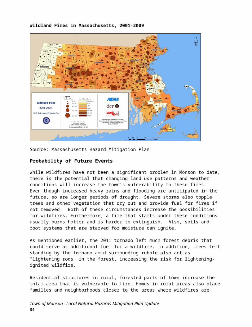
When evaluating the region’s risk for drought on a national level, utilizing a measure called the Palmer Drought Severity Index, Massachusetts is historically in the lowest percentile for severity and risk of drought.8 However, global warming and climate change may have an effect on drought risk in the region. With the projected temperature increases, some scientists think that the global hydrological cycle will also intensify. This would cause, among other effects, the potential for more severe, longer-lasting droughts. Monson therefore considers the probability of future drought events to be “moderate.”
Impact
Due to the water richness of Western Massachusetts, Monson is unlikely to be adversely affected by anything other than a major, extended drought. While such a drought would require water saving measures to be implemented, there would be no foreseeable damage to structures or loss of life resulting from the hazard.
Vulnerability
Based on the above assessment, Monson faces a “4 – low” hazard index risk of drought.
8 National Drought Mitigation Center – http://drought.unl.edu
Town of Monson– Local Natural Hazards Mitigation Plan Update 39
Extreme Temperatures
Hazard Description
As per the Massachusetts Hazard Mitigation Plan, extreme cold is a dangerous situation that can result in health emergencies for susceptible people, such as those without shelter or who are stranded or who live in homes that are poorly insulated or without heat. There is no universal definition for extreme temperatures, with the term relative to local weather conditions. For Massachusetts, extreme temperatures can be defined as those that are far outside the normal ranges. The average temperatures for Massachusetts are:
Winter (Dec-Feb) Average = 27.51ºF Summer (Jun-Aug) Average = 68.15ºF
Criteria for issuing alerts for Massachusetts are provided on National Weather Service web pages:http://www.erh.noaa.gov/box/warningcriteria.shtml.
Location
Any instances of extreme temperatures that have occurred in the past occurred throughout Monson. Extreme cold or heat usually requires the opening of shelters on a few occasions per year.
Extent
As per the Massachusetts Hazard Mitigation Plan, the extent (severity or magnitude) of extreme cold temperatures are generally measured through the Wind Chill Temperature Index. Wind Chill Temperature is the temperature that people and animals feel when outside and it is based on the rate of heat loss from exposed skin by the effects of wind and cold. The chart shows three shaded areas of frostbite danger. Each shaded area shows how long a person can be exposed before frostbite develops. In Massachusetts, a wind chill warning is issued by the NWS Taunton Forecast Office when the Wind Chill Temperature Index, based on sustained wind, is –25ºF or lower for at least three hours.
Extreme temperatures would affect the whole community.
Town of Monson– Local Natural Hazards Mitigation Plan Update 40

Wind Chills
For extremely hot temperatures, the heat index scale is used, which combines relative humidity with actual air temperature to determine the risk to humans. The NWS issues a Heat Advisory when the Heat Index is forecast to reach 100-104 degrees F for 2 or more hours. The NWS issues an Excessive Heat Warning if the Heat Index is forecast to reach 105+ degrees F for 2 or more hours. The following chart indicates the relationship between heat index and relative humidity:
Town of Monson– Local Natural Hazards Mitigation Plan Update 41

Heat Index
Previous Occurrences
The following are some of the lowest temperatures recorded in parts of Massachusetts for the period from 1895 to present (Source: NOAA, www.ncdc.noaa.gov.), and serve as the best indicators of the temperature extremes that Monson can experience:
Blue Hills, MA- –21°F Boston, MA- –12°F Worcester, MA- –19°F
The following are some of the highest temperatures recorded for the period from 1895 to present (Source: NOAA, www.ncdc.noaa.gov.), and serve as the best indicators of the temperature extremes that Monson can experience:
• Blue Hills, MA - 101°F• Boston, MA - 102°F• Worcester, MA - 96°F
Extreme heat usually requires the opening of shelters on a few occasions per year. In the winters of 2014 and 2015, warming centers were opened for extremely cold temperatures due to the “polar vortex.”
Probability of Future Events
Town of Monson– Local Natural Hazards Mitigation Plan Update 42

The probability of future extreme temperatures is considered to be "low," or between 1 and 10 percent in any given year.
Impact
The impact of extreme heat or cold in Monson is considered to be "minor," with no property damage and very limited affect on humans.
Vulnerability
Monson’s vulnerability from extreme heat and cold is considered to be, "5 - Lowest Risk."
Other Hazards
In addition to the hazards identified above, the Hazard Mitigation Team reviewed the full list of hazards listed in the Massachusetts Hazard Mitigation Plan. Due to the location and context of the City, coastal erosion, landslides, and tsunamis, were determined to not be a threat.
Town of Monson– Local Natural Hazards Mitigation Plan Update 43

4: CRITICAL FACILITIES
Facility Classification
A Critical Facility is defined as a building, structure, or location which:
Is vital to the hazard response effort Maintains an existing level of protection from hazards for community residents and property Would create a secondary disaster if a hazard were to impact it
The Critical Facilities List for the Town of Monson has been identified utilizing a Critical Facilities List provided by the State Hazard Mitigation Officer. Monson Hazard Mitigation Workgroup has broken up this list of facilities into four categories:
Facilities needed for emergency response in the event of a hazard event.
Facilities identified as non-essential and not required in an emergency response event, but which are considered essential for the everyday operation of the Town.
Facilities or institutions that include special populations which would need additional attention in the event of a hazard event.
Potential facilities that could be used as resources to assist in mitigating a hazard
The critical facilities and evacuation routes potentially affected by hazard areas are identified following this list. The Past and Potential Hazards/Critical Facilities Map (Appendix D) also identifies these facilities.
Town of Monson– Local Natural Hazards Mitigation Plan Update 44

Category 1 – Emergency Response Services
The Town has identified the Emergency Response Facilities and Services as the highest priority in regards to protection from natural and man-made hazards.
1. Emergency Operations Center Municipal Office Building/Fire/Police Station — 200 Main Street
2. Fire Station Monson Fire Station – 200 Main Street
3. Police Station Monson Police Station – 200 Main Street
4. Highway Garage Monson Highway Department – Main Street
5. Water and Sewer Department Monson Water and Sewer Department – Main Street
6. Emergency Fuel Stations DPW Garage
7. Emergency Electrical Power Facility Emergency Generator, Monson Highway Department Two Emergency Generators, Monson Fire and Police DepartmentsPortable Generator, Monson Water Department
8. Emergency Shelters Quarry Hill Street –Margaret StreetMonson Fire Station—Main StreetMonson Senior Center – Main Street (includes kitchen facilities)Granite Valley Middle School – ThompsonPalmer Senior High School – Main Street (main regional shelter)Monson Sr. High School—Margaret Street
9. Dry Hydrants - Fire Ponds - Water Sources Numerous locations in Monson, so please refer to the Critical Facilities Map at the end of this document.
10. Utilities Columbia Gas Pipeline (distribution)Buckeye Partners / Exxon Mobil Pipeline – North end of town along Route 20, services distribution plantsTennessee Gas Pipeline (transmission)
Town of Monson– Local Natural Hazards Mitigation Plan Update 45

Verizon Switching Station – Main StreetSubstation – Fenton RoadSolar Farm – Nearest is located in Palmer; not critical to power grid
11. Helicopter Landing Sites
Veteran’s Field – Rear of Municipal BuildingQuarry Hill Community SchoolMonson Developmental CenterField along Route 32Corner of Easthill Road and Brimfield RoadConant Brook Dam – Wales RoadWilbraham Road and Wade Road – FieldHillcrest Cemetery
12. Communications Verizon Switching StationHovey Road Communications Station – Three cell phone towers, Comcast Cable, law enforcement and regular public safety communicationsFire Station tower – Roof of Fire Station, 200 Main StreetEast Hill Communication Tower – East Hill Road (critical to fire and highway department communications)Dispatch Tower – Municipal Building (200 Main Street)Cedar Swamp Road – cellular tower and law enforcement tower
13. Primary Evacuation Routes Route 32 - north and southRoute 20 (Brimfield Road) – east and westWilbraham Road – east and westWales Road – east and westLower Hampden Road
Upper Hampden Road Upper Palmer Road
14. Bridges Located on Evacuation Routes All routes, with the exception of Wales Road, have bridges located on them. In the worst case scenario, all routes could be limited because of flood waters, though Brimfield Road would be the least impacted. In particular, Route 32 at the Palmer town line floods easily.
Category 2 – Non Emergency Response Facilities
The town has identified these facilities as non-emergency facilities; however, they are considered essential for the everyday operation of Monson.
1. Water SupplyGP Well #1 – Bethany RoadGP Well #2 – Palmer Road
Town of Monson– Local Natural Hazards Mitigation Plan Update 46

GP Well #3 – Bunyan Road
Water tank at MDC (currently empty)
2. Sewer Infrastructure (Pump Stations) Hospital Road pumping station
Category 3 – Facilities/Populations to Protect
The third category contains people and facilities that need to be protected in event of a disaster.
1. Special Needs Population Kristy Jo’s Daycare – Bethany RoadColonial Village Senior Housing – State StreetLittle Lamb Daycare – Park AvenueMoon Mountain Daycare – Woodhill RoadMrs. B’s Daycare – Stewart AveNancy’s Family Daycare – Palmer RoadScantic Valley YMCA before/after school program – Granite Valley School, Thompson StreetSmall Steps Daycare – Town Farm RoadStimulations Preschool – Thompson StreetSunny Brook Home Learning Childcare – sunny Brook Drive
2. Elderly Housing/Assisted Living Colonial Village Senior Housing (Housing Authority) – State Street
Group Home – State Avenue Group Home – Pine Ridge
Pine Street Group Home – 3 McCray CircleState group home facilities – Waid Road, Main STreet
3. Recreation Areas Pulpit Rock Lake – Dickerson / Maxwell RoadFlynt Park – Park RoadBrimfield State Forest / Dean Pond – Monson, Brimfield and Wales town linesParadise Lake – Lakeside DriveSpringfield Sportsman Club – Wood Hill RoadConant Brook Dam - Wales Road/Blanchard RoadCedar Swamp – Moulton Hill RoadCushman Field – Washington StreetHillside School – Thompson LaneMonsoon-Brimfield-Wales (MBW) Trail - 14.5 miles in totalKeep Homestead Museum – Ely RoadQuarry Hill Community School – Thompson StreetVeterans Fields and Tennis Courts – Man and State Streets
Town of Monson– Local Natural Hazards Mitigation Plan Update 47

Quaboag Country Club – Palmer RoadNorcross Wildlife Sanctuary – Wales-Monson RoadO’Connors Fields – Bethany RoadPeaked Mountain – Butler RoadQuaboag Riders Club – Cat RockSunset View Campground – Town Farm Road
4. Schools Granite Valley Middle School – Thompson Street Monson Senior High School – Margaret StreetQuarry Hill Community Elementary School – Margaret Street
5. Churches First CongregationalFirst MethodistSt Patrick’s Catholic ChurchSilver Street Chapel
Unitarian/Universalist Church
6. Historic Buildings/Sites Monson Center Historic District – Junction of Main and CushmanMonson Development Center – State AvenueMemorial Hall – Main Street
7. Apartment Complexes Colonial VillageCushman HallState Street School70 Main StreetQuaboag HeightsWoodridge CondominiumsBliss & Main Apartments
8. Employment CentersMonson Savings BankDiversified MetalsIndustrial TransferLamcotek
9. CampsSunset View – Town FarmPartridge Hollow – Sunset Road
10. Mobile Home Parks Hospital Road – 55 units **** IN FLOOD PLAIN
Town of Monson– Local Natural Hazards Mitigation Plan Update 48

Category 4 – Potential Resources
Contains facilities that provide potential resources for services or supplies.
1. Heavy & Small Equipment Suppliers - Existing contracts with outside vendors
2. Gravel Pits - Cedar Swamp Road (inactive)
Town of Monson– Local Natural Hazards Mitigation Plan Update 49
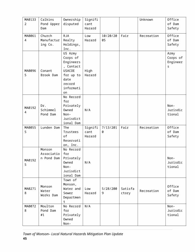
Critical Facilities and Evacuation Routes Potentially Affected by Hazard Areas
Hazard Type Hazard Area Critical Facilities Affected Evacuation Routes Affected
Flooding Downtown Monson Town Hall (including town data storage and servers), Highway Garage, Police Station, Historic Structures, Fire Department, Heavy Freight
Route 32
Severe Snowstorms/Ice Storms
Entire Town None None
Severe Thunderstorms (microbursts) which cause wind damage
Telephone, Power Lines Energy and Communication None
Hurricanes Downtown Monson Town Hall, Highway Garage, Police Station, Historic Structures, Fire Department
Route 32
Tornadoes Entire Town None None
Wildfire/Brushfire None None None
Earthquakes Entire Town Highway Garage, Memorial Hall, Older Churches Route 32
Dam Failures Downtown Monson Town Hall, Highway Garage, Police Station, Historic Structures, Fire Department
Route 32
Drought Entire Town Water Supply None
Past and Potential Hazards/Critical Facilities Map (Appendix D)
Town of Monson– Local Natural Hazards Mitigation Plan Update 50
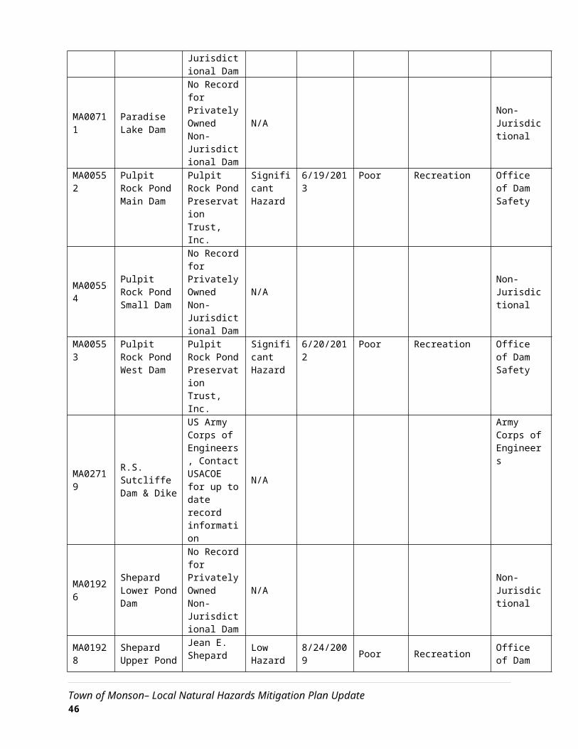
5: CURRENT MITIGATION STRATEGIES
One of the steps of this Hazard Mitigation Plan is to evaluate all of the Town’s existing policies and practices related to natural hazards and identify potential gaps in protection. After reviewing these policies and the hazard identification and assessment, the Town Hazard Mitigation Workgroup developed a set of hazard mitigation strategies it would like to implement.
The Town of Monson has developed the following goal to serve as a framework for mitigation of the hazards identified in this plan.
For the extent of this analysis, the Workgroup reviewed the following Town documents:
Zoning Bylaws
Subdivision Rules and Regulations
Comprehensive Emergency Management Plan
Town Open Space and Recreation Plan
Master Plan
Town of Monson– Local Natural Hazards Mitigation Plan Update 51
Goal Statement
To minimize the loss of life, damage to property, and the disruption of governmental services and general business activities due to the following hazards: flooding, severe snowstorms/ice storms, severe thunderstorms, hurricanes, tornadoes, wildfires/brushfires, earthquakes, dam failures, drought, and extreme temperatures.

Overview of Mitigation Capabilities by Hazard
An overview of the general capabilities underlying Monson’s mitigation strategies for each of the hazards identified in this plan is as follows:
Flooding
The key factors in flooding are the water capacity of water bodies and waterways, the regulation of waterways by flood control structures, and the preservation of flood storage areas and wetlands. As more land is developed, more flood storage is demanded of the town’s water bodies and waterways. The Town currently addresses this problem with a variety of mitigation tools and strategies. Infrastructure like dams and culverts are in place to manage the flow of water. In addition, Monson has a “Replanting Monson” tree committee, which is focusing on both replacing trees lost to the 2011 tornado and tree plantings town-wide. Strategically located trees can help reduce flash flooding events by absorbing stormwater flow, and reduce erosion by holding soils in place. The Replanting Monson Committee could improve and expand upon their current work through addressing tree plantings for stormwater mitigation and flood control.
Monson also has a commendable record of land protection in town, and active community preservation and conservation commissions that continually pursue land protection opportunities and grants.
The Town substantially updated its zoning bylaw in 2014 to incorporate strategies to concentrate development in existing developed areas, encourage low impact development, provide more flexibility in parking requirements (and thus reduce impervious surfaces), and encourage more landscaping and tree preservation in commercial developments to control stormwater.
Flood-related regulations and strategies are included in the Town’s general bylaws, zoning by-law, and subdivision regulations, as outlined below.
Monson Zoning DistrictsMonson has eight base zoning districts and three overlay districts. These land use regulations serve to limit or regulate development in floodplains, manage stormwater runoff, and protect groundwater and wetland resources, the latter of which often provide important flood storage capacity.
The base districts define the allowed uses and dimensional requirements, while the overlay districts establish additional restrictions in certain areas for the protection of specific public interests. The zoning ordinance has several provisions that mitigate the potential for flooding, including:
Floodplain DistrictThe Floodplain District is defined as all lands designated as Zone A or Zone A1-30 on the Town of Monson Flood Insurance Rate Maps and the floodway boundaries delineated on the Monson Flood Boundary and Floodway Map. The district is intended to maintain the water table, protect water recharge areas, and protect against flooding by limiting uses in flood-prone areas to conservation; outdoor recreation; wildlife management areas; foot, bicycle, and horse paths; grazing and farming;
Town of Monson– Local Natural Hazards Mitigation Plan Update 52

forestry; nurseries; lawful pre-existing dwellings; and temporary non-residential structures. Certain uses are permitted in this district by Special Permit if appropriate flood proofing measures are taken.
Water Supply Protection DistrictThe Water Supply Protection District is intended to protect lands within the primary recharge area of groundwater aquifers and the watershed areas of reservoirs which now or may in the future provide public water supply. To protect surface and groundwater resources, the overlay district prohibits many noxious uses such as solid waste disposal facilities, disposal of liquid or leachable wastes, and storage of petroleum products. Commercial or industrial uses that are allowed in the underlying district may be allowed by Special Permit.
Other Provisions
Stormwater BylawA stormwater bylaw in Monson’s zoning code sets minimum standards for stormwater management on new or redeveloped sites. The bylaw identifies flooding as one of the reasons for the bylaw, and encourages infiltration when possible to assist in groundwater recharge.
Site Plan ApprovalSite plan approval is intended to ensure that new development is consistent with the Town’s visual and environmental character, protects property values, and provides adequate drainage and access. The review process is required for construction or exterior alteration of commercial or industrial structures, residential developments requiring approval under the Subdivision Control Law (M.G.L. Chapter 41), and the development of certain other uses noted in the Use Regulations Table of the Zoning Bylaw. Criteria for site plan approval include conformance with the Zoning Bylaw; compatible design and architectural style; adequate water supply and wastewater disposal systems; convenient and safe vehicular and pedestrian access; protection of natural and cultural resources; appropriate screening from the public view; and minimization of burden to the Town’s services and infrastructure.
Wireless Communications Facilities RegulationsWireless Communications Facilities Regulations were added to the Zoning Bylaw in May 2000. The bylaw establishes siting criteria and standards for wireless communication facilities. The purpose of the bylaw is to minimize the adverse impact of such facilities on adjacent properties, scenic views and the Town’s character, and limit the number of such facilities by promoting shared use of existing facilities.
Open Space Communities BylawOpen space residential development is a development technique whereby homes are grouped on one or more portions of a lot that are most suitable for development, in order to protect the rest of the site as common open space. Monson’s Open Space Communities (OSC) Bylaw allows the development of an open space community in the Rural Residential District by Special Permit from the Planning Board. In an Open Space Community, individual house lots are smaller than the ordinary minimum zoning requirement, but no more lots are allowed than would be allowed in a conventional subdivision. The land that is preserved by the use of smaller lot sizes is dedicated as common open space to be protected from development in perpetuity.
OSC design can only be applied to residential subdivisions where several homes are being developed at once. As noted above, most of Monson’s residential development is in the form of single-lot, Approval-
Town of Monson– Local Natural Hazards Mitigation Plan Update 53

Not-Required development, which is not conducive to OSC design. Mainly for this reason, Monson’s OSC Bylaw has never been used. Typically, as a community develops, substantial amounts of subdivision development will not occur until most of the ANR development opportunities have already been exhausted. Therefore, while the OSC bylaw is a good tool for Monson to keep for future growth management, it is unlikely to be utilized in the immediate future.
Severe Snowstorms / Ice Storms
Winter storms can be especially challenging for emergency management personnel. The Massachusetts Emergency Management Agency (MEMA) serves as the primary coordinating entity in the statewide management of all types of winter storms and monitors the National Weather Service (NWS) alerting systems during periods when winter storms are expected. Even though the storm has usually been forecast, there is no certain way for predicting its length, size or severity. Therefore, mitigation strategies must focus on preparedness prior to a severe snow/ice storm.
The Town’s current mitigation tools and strategies focus on preparedness, with many regulations and standards established based on safety during storm events. To the extent that some of the damages from a winter storm can be caused by flooding, flood protection mitigation measures also assist with severe snowstorms and ice storms. Tree trimming is also regularly carried out by the Town for municipally-owned trees and by Eversource for trees in the electric right-of-way. In addition, the Town enforces building codes through a building inspector and assistant building inspector, ensuring that structures are built to codes that support snow weight. Information about avoiding carbon monoxide poisoning during winter storms is posted on the town fire department’s website.
Hurricanes
Hurricanes provide the most lead warning time of all identified hazards, because of the relative ease in predicting the storm’s track and potential landfall. MEMA assumes “standby status” when a hurricane’s location is 35 degrees North Latitude (Cape Hatteras) and “alert status” when the storm reaches 40 degrees North Latitude (Long Island). Even with significant warning, hurricanes can do significant damage – both due to flooding and severe wind.
The flooding associated with hurricanes can be a major source of damage to buildings, infrastructure and a potential threat to human lives. Flood protection measures can thus also be considered hurricane mitigation measures. The high winds that often accompany hurricanes can also damage buildings and infrastructure, similar to tornadoes and other strong wind events.
Severe Thunderstorms / Winds / Tornadoes
Most damage from tornadoes and severe thunderstorms come from high winds that can fell trees and electrical wires, generate hurtling debris and, possibly, hail. According to the Institute for Business and Home Safety, the wind speeds in most tornadoes are at or below design speeds that are used in current building codes, making strict adherence to building codes a primary mitigation strategy. Many of the Town of Monson’s In addition, current land development regulations, such as restrictions on the height of telecommunications towers, can also help prevent wind damages.
Town of Monson– Local Natural Hazards Mitigation Plan Update 54

The Town offers a CodeRed Weather Warning services, which automatically calls citizens in Monson who are in the path of severe weather, just moments after a warning has been issued by the National Weather Service.
Wildfires / Brushfires
Wildfire and brushfire mitigation strategies involve educating people about how to prevent fires from starting, as well as controlling burns within the town. The Town already carries out fire prevention awareness programs in the schools and among seniors.
Earthquakes
Although there are five mapped seismological faults in Massachusetts, there is no discernible pattern of previous earthquakes along these faults nor is there a reliable way to predict future earthquakes along these faults or in any other areas of the state. Consequently, earthquakes are arguably the most difficult natural hazard for which to plan.
Most buildings and structures in the state and the town of Monson were constructed without specific earthquake resistant design features. In addition, earthquakes precipitate several potential devastating secondary effects such as building collapse, utility pipeline rupture, water contamination, and extended power outages. Therefore, many of the mitigation efforts for other natural hazards identified in this plan may be applicable during the Town’s recovery from an earthquake.
Dam Failure
Dam failure is a highly infrequent occurrence, but a severe incident could prove catastrophic. In addition, dam failure most often coincides with flooding, so its impacts can be multiplied, as the additional water has nowhere to flow. The only mitigation measures currently in place are the state regulations governing the construction, inspection, and maintenance of dams. This is managed through the Office of Dam Safety at the Department of Conservation and Recreation. The Town could choose to build upon state regulation efforts by prioritizing dams to remove, particularly smaller ones that may not be actively maintained but pose a threat to those downstream.
Drought
Although Massachusetts does not face extreme droughts like many other places in the country, it is susceptible to dry spells and drought. Drought can most likely be effectively mitigated in regions like the Pioneer Valley if measures are put into place, such as ensuring that groundwater is recharged. The Town’s stormwater management bylaw requires the use of infiltration as much as practicable for new development or redevelopment sites in order to allow for the recharge of groundwater. In addition, amendments to the zoning bylaw in 2014 have added more considerations for the integration of trees and use of plants with little to no irrigation requirements in commercial development.
Extreme Temperatures
Extreme temperatures are likely to become more common due to climate change. The impacts of extreme temperatures are often emergency response-related, such as the provision of heating or
Town of Monson– Local Natural Hazards Mitigation Plan Update 55
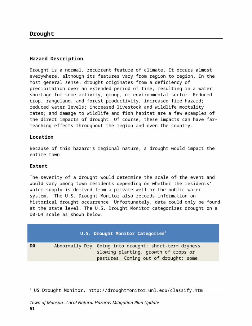
cooling centers during extreme temperature events. The Town of Monson occasionally opens heating and cooling shelters for these events. Other mitigation measures include increasing awareness of extreme temperature risk to health and properties and assisting vulnerable populations in extreme temperature events. The 2014 amendments to the zoning bylaw also add commercial landscaping requirements with a specific purpose to reduce heat-island effects, among others.
General
The Town has several financial and administrative capabilities to support its natural hazard mitigation strategies. This includes a Finance Committee that reviews and recommends all expenditures for the town, and has the ability to levy taxes for specific services, and to incur debt through general obligation bonds. The Town does not collect impact fees for new development. Due to the town’s limited financial resources, the Town works proactively and cooperatively to seek grant funds and other cooperative assistance in place of raising taxes or issuing debt whenever possible. Various town staff perform grant writing activities as warranted.
The Town Administrator serves as the Emergency Management Director. The Town of Monson has a designated floodplain administrator. Its master plan was last updated in 2004
Town of Monson– Local Natural Hazards Mitigation Plan Update 56
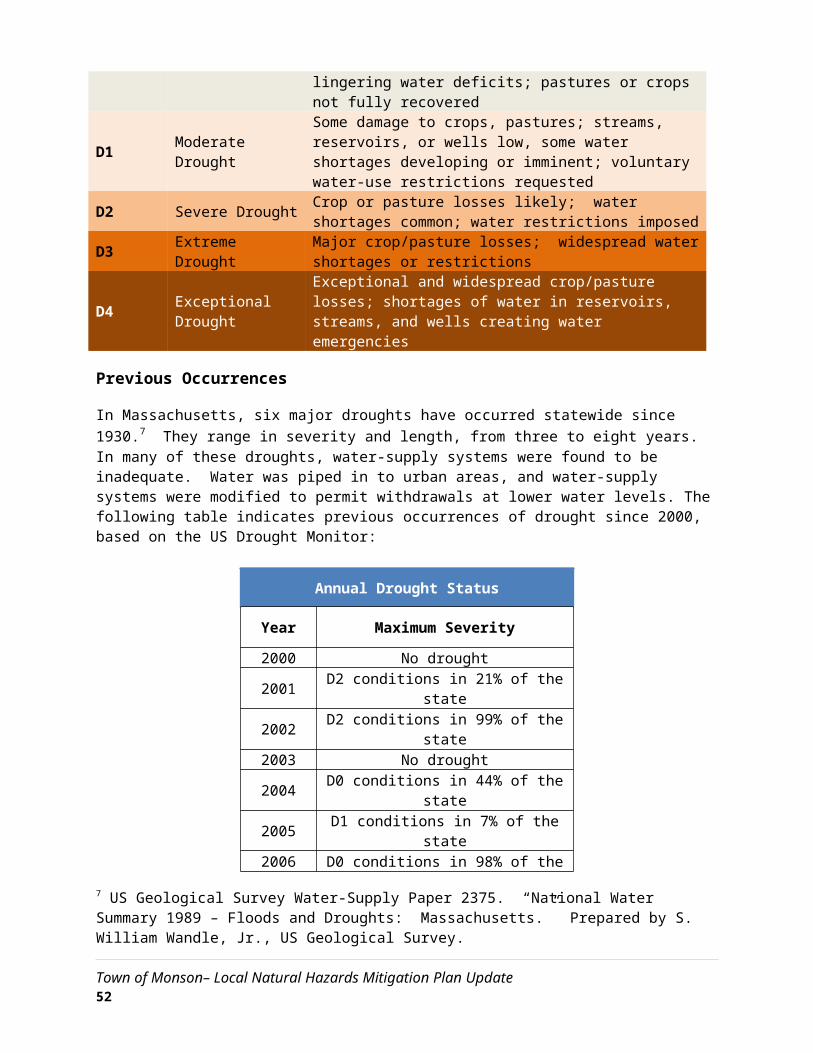
Town of Monson– Local Natural Hazards Mitigation Plan Update 57

Existing Mitigation Capabilities and Strategies
Strategies that were previously completed prior to 2007, or completed between 2007 and 2014, are listed below and noted under the “effectiveness” column. Strategies that were completed since the last version of the plan are listed as well.
As part of the development of this plan update in 2015 and 2016, the Hazard Mitigation Workgroup evaluated each mitigation strategy to determine its effectiveness and whether any improvements could be made.
Capability or Strategy Description Hazards Mitigated
Area Covered Effectiveness Potential Changes
Examine current notification system including feasibility of Reverse 911. Develop a preliminary project proposal
and cost estimate.General/All Entire Town Effective
Increase use of specific mapping features of the
Reverse 911 system, such as identifying flood areas.
Using construction dates of existing shelters, identify those shelters that were built to Massachusetts’ current
seismic code.General / All Entire Town
Not effective. Shelters were
constructed prior to existing seismic
codes and not cost effective to
retrofit.
Check against new seismic codes.
Update Monson’s Natural Hazard Mitigation Plan every Five (5) Years. General / All Entire Town Effective
None.
Actively pursue conservation and permanent protection of lands subject to flooding to prevent damage to life
and property from flooding.Flooding Flood zones
Not effective, as there is little land to acquire in flood
zones.
None.
The town should evaluate whether to become a part of FEMA’s Community Rating System. Flooding Flood zones
Expected to be effective, but no progress to date.
Review in context of new maps to see how many more households are impacted by
updated flood zones.
Town of Monson– Local Natural Hazards Mitigation Plan Update 58

Capability or Strategy Description Hazards Mitigated
Area Covered Effectiveness Potential Changes
Establish a plan to prioritize and acquire undeveloped properties within flood zones throughout Town. Flooding Flood zones Effective
Undeveloped properties need to be re-identified.
Prepare a priority list and seek funding through the Hazard Mitigation Grant Program (HMGP) for the
replacement of undersized culverts throughout town, both those currently identified and culverts that have –
yet-to-be identified.
Flooding Entire Town Effective
Identify all undersized culverts.
Drainage repairs on roads that consistently ice over to lessen the potential for future damage to Monson’s
residents.
Severe Snow/Ice Storms Select Roads Effective
Prioritize repairs.
Reverse 911 for mass notification in the event of a large catastrophic complication from a Hurricane, such as a
dam breach.Hurricanes Entire Town Effective
Incorporate with previous Reverse 911 strategy.
Clear high-risk trees away from critical infrastructure and facilities to ensure that these will be most fully
operational in all events, especially wind related events.Tornadoes Select Areas Effective
None. Complete.
Tornado education pamphlet to help residents identify tornado conditions as they might appear in Monson. Tornadoes Entire Town Not effective; no
action ever taken.
Create education pamphlet that is not specific to
tornadoes.
Continue to develop and distribute an educational pamphlet on fire safety and prevention. Wildfires/Brushfires Entire Town
Effective. Wildfire hazard
information is on town website.
None. Wood in forests knocked down by tornado is decaying and less of a threat.
Install sufficient back-up generator in all shelters and critical facilities to ensure operations in the event of a
primary power failure.Earthquakes Entire Town Effective
None. Back-up generator is effective.
Map inundation zones to determine how heavily impacted critical facilities in the center of town would be
in the event of a major dam breach.Dam Failure Select Areas Effective
None. Complete.
Town of Monson– Local Natural Hazards Mitigation Plan Update 59

Capability or Strategy Description Hazards Mitigated
Area Covered Effectiveness Potential Changes
Construct flood walls at critical facilities to lessen the impact of a major Dam Breach. Dam Failure Select Areas Not effective.
None. Not cost effective.
Establish action plan that addresses hazardous chemical spills and releases at EPA Tier II locations and on
transportation routes.Man-Made Disasters Entire Town
Effective. Action plan is part of
CEMP.
None. Complete.
Town of Monson– Local Natural Hazards Mitigation Plan Update 60

Deleted or Completed Mitigation Strategies
Several mitigation strategies listed in the 2007 version of the Monson Hazard Mitigation Plan have been removed in this 5-year update. Strategies were deleted for one of two reasons: 1) They are determined as no longer effective to mitigate a hazard, 2) They are in need of replacement by a more specific mitigation strategy.
Action Hazards Mitigated
Responsible Agency Reason for Deletion
Examine current notification system including feasibility of
Reverse 911. Develop a preliminary project proposal
and cost estimate.
All EMD
Reverse 911 has been adopted and is a capability. This strategy needs to be further
defined to make the tool more hazard-specific.
Update Monson’s Natural Hazard Mitigation Plan every
Five (5) Years.All EMD
Strategy is too general and Monson updates its plan as a matter of course (existing
capability).Actively pursue conservation and permanent protection of lands subject to flooding to prevent damage to life and
property from flooding.
Flooding Conservation Commission
Not much land available for acquisition in flood zones or areas.
Reverse 911 for mass notification in the event of a
large catastrophic complication from a
hurricane, such as a dam breach.
All EMDReverse 911 is now a capability. Strategy can be updated to make Reverse 911 tool more
hazard-specific.
Town of Monson– Local Natural Hazards Mitigation Plan Update 61

Clear high-risk trees away from critical infrastructure and facilities to ensure that these will be most fully operational in all events, especially wind
related events.
Severe windThunderstorms
Eversource
Tree Warden
Strategy is complete and is now an existing capability.
Tornado education pamphlet to help residents identify
tornado conditions as they might appear in Monson.
Tornadoes EMD Emergency preparedness is a more effective message than tornado preparedness.
Install sufficient back-up generator in all shelters and
critical facilities to ensure operations in the event of a
primary power failure.
AllTown
Administrator / EMD
Complete
Map inundation zones to determine how heavily
impacted critical facilities in the center of town would be in the event of a major dam
breach.
Dam FailureEMD / U.S.
Army Corps of Engineers
Complete. Secured from USACE in 2012.
Construct flood walls at critical facilities to lessen the impact
of a major Dam Breach.Dam Failure Town
Administrator Not cost effective.
Establish action plan that addresses hazardous chemical spills and releases at EPA Tier
II location and on transportation routes.
FloodsHurricanesWildfires
Fire Department Complete. Part of CEMP.
Town of Monson– Local Natural Hazards Mitigation Plan Update 62

Previously Identified and New Strategies
Several of the action items that were identified in the 2007 Hazard Mitigation Plan have been deferred. Strategies were deferred either because of insufficient staff resources or funding, or the strategy was determined not to be worth implementing based on the benefit that it would provide.
Other action items previously identified in the 2007 Hazard Mitigation Plan are currently continuing, either because they require more time to secure funding or their construction process is ongoing. There are no additional mitigation strategies that have been completed or implemented since the previous plan was published.
In addition to deferred and continuing mitigation strategies, the Hazard Mitigation Committee identified several new strategies that are also being pursued. These new strategies are based on experience from previous strategies and new hazards that have been identified since the last Hazard Mitigation Plan was developed.
Prioritized Implementation Plan
Several of the action items previously identified in the 2007 Hazard Mitigation Plan are currently continuing, either because they require more time to secure funding or their construction process is ongoing. In addition, the Hazard Mitigation Committee identified several new strategies that are also being pursued. These new strategies are based on experience with currently implemented strategies, as well as the hazard identification and risk assessment in this plan. Overall mitigation strategy priorities have not changed since the last version of this plan, with specific mitigation strategies addressing all identified hazards through a combination of planning, public outreach, and infrastructure improvements.
Prioritization Methodology
The Monson Hazard Mitigation Planning Committee reviewed and prioritized a list of previously identified and new mitigation strategies using the following criteria:
Application to multiple hazards – Strategies are given a higher priority if they assist in the mitigation of several natural hazards.
Time required for completion – Projects that are faster to implement, either due to the nature of the permitting process or other regulatory procedures, or because of the time it takes to secure funding, are given higher priority.
Estimated benefit – Strategies which would provide the highest degree of reduction in loss of property and life are given a higher priority. This estimate is based on the Hazard Identification and Analysis Chapter, particularly with regard to how much of each hazard’s impact would be mitigated.
Town of Monson– Local Natural Hazards Mitigation Plan Update 63

Cost effectiveness – in order to maximize the effect of mitigation efforts using limited funds, priority is given to low-cost strategies. For example, regular tree maintenance is a relatively low-cost operational strategy that can significantly reduce the length of time of power outages during a winter storm. Strategies that have identified potential funding streams, such as the Hazard Mitigation Grant Program, are also given higher priority.
Eligibility Under Hazard Mitigation Grant Program – The Hazard Mitigation Grant Program (HMGP) provides grants to states and local governments to implement long-term hazard mitigation measures after a major disaster declaration. The purpose of the HMGP is to reduce the loss of life and property due to natural disasters and to enable mitigation measures to be implemented during the immediate recovery from a disaster. Funding is made available through FEMA by the Massachusetts Emergency Management Agency. Municipalities apply for grants to fund specific mitigation projects under MEMA requirements
The following categories are used to define the priority of each mitigation strategy:
Low – Strategies that would not have a significant benefit to property or people, address only one or two hazards, or would require funding and time resources that are impractical
Medium – Strategies that would have some benefit to people and property and are somewhat cost effective at reducing damage to property and people
High – Strategies that provide mitigation of several hazards and have a large benefit that warrants their cost and time to complete
Several hazard mitigation strategies identified in the previous Hazard Mitigation Plan have not yet been completed, but were changed in priority during the update of this plan by the Hazard Mitigation Committee. The Committee changed priorities by evaluating the entire list of mitigation strategies in a comprehensive manner according to the factors listed above. For strategies that have changed in priority, the previous priority is provided in parenthesis in the “Priority” column.
Cost Estimates
Each of the following implementation strategies is provided with a cost estimate. Projects that already have secured funding are noted as such. Where precise financial estimates are not currently available, categories were used with the following assigned dollar ranges:
Low – cost less than $50,000
Medium – cost between $50,000 – $100,000
High – cost over $100,000
Cost estimates take into account the following resources:
Town of Monson– Local Natural Hazards Mitigation Plan Update 64

City staff time for grant application and administration (at a rate of $25 per hour)
Consultant design and construction cost (based on estimates for projects obtained from city and general knowledge of previous work in city)
City staff time for construction, maintenance, and operation activities (at a rate of $25 per hour)
Project Timeframe
Each strategy is provided with an estimated length of time it will take for implementation. Where funding has been secured for the project, a specific timeframe is provided for when completion will occur. However, some projects do not currently have funding and thus it is difficult to know exactly when they will be completed. For these projects, an estimate is provided for the amount of time it will take to complete the project once funding becomes available.
Town of Monson– Local Natural Hazards Mitigation Plan Update 65

Mitigation Capabilities and Strategies to be Implemented
Mitigation Action Status Action Type Hazards Mitigated
Responsible Party Timeframe Potential
Funding Est. Cost Priority
Using construction dates of existing shelters,
identify those shelters that were built to
Massachusetts’ current seismic code.
Dates have been obtained. Capability Earthquakes Building
Department 6 months Local funds Low Low
Evaluate whether to become a part of FEMA’s
Community Rating System based on new FEMA flood
zones.
No action taken to date. Strategy Floods Town Planner
EMD 1 year DLTA, LTALocal funds Low Low
Prepare a prioritized list for the replacement of
undersized culverts throughout town.
No action taken to date. Strategy Floods
HurricanesHighway
Department 6 mo. HMGPLocal funds High High
Conduct drainage repairs on roads that consistently
ice over to lessen the potential for future risk to
motorists.
No action taken to date. Strategy Snowstorms/ice Highway
Department2 years HMGP
Chp. 90 High Medium
Develop point-to-point redundant datawave
system for data storage, data retrieval, and
communications in event that central servers are
incapacitated by flood or other natural hazard at
town hall.
No action to date. Strategy
HurricanesFloodingTornado
Police Dept.Fire Dept.
Town OfficesSchools
2 years
EMPGTown
MeetingJustice
Assistance Grants
High High
Town of Monson– Local Natural Hazards Mitigation Plan Update 66

Mitigation Capabilities and Strategies to be Implemented
Mitigation Action Status Action Type Hazards Mitigated
Responsible Party Timeframe Potential
Funding Est. Cost Priority
Install flood monitoring alarm equipment on the
Chicopee River and Conant Brook.
No action to date. Strategy Flooding EMD 2 years
HMPGEMPG Medium Medium
Conduct educational outreach about insurance
and safety related to flooding.
New FEMA maps issued in 2014; affected homeowners notified about
new status
Capability
Flooding
Hurricanes
Town PlannerTown
Administrator6 months
HMGEMPG
Local fundsLow Medium
Inventory window exposure to natural
hazards on critical facilities (such as EOC).
No action to date. Capability
Wind
Tornadoes
Earthquakes
Town AdministratorPolice Dept.
2 years Local funds Low Medium
Inventory town-owned critical facilities for
earthquake vulnerability.
No action to date. Capability Earthquakes Building
Department 6 mo. Local funds Low Low
Add typical/historic inundation and flood areas to Reverse 911 system so that the targeted area can
be notified in a flood event.
Reverse 911 software is in
operation, inundation areas have
been mapped separately.
Strategy
Flooding
Dam Failure
Town AdministratorPolice Dept. Fire Dept.
1 year Local funds Low Medium
Town of Monson– Local Natural Hazards Mitigation Plan Update 67

Mitigation Capabilities and Strategies to be Implemented
Mitigation Action Status Action Type Hazards Mitigated
Responsible Party Timeframe Potential
Funding Est. Cost Priority
Research installation needs for install air
conditioning into Quarry Hill shelter for extreme
heat events.
No action to date. Strategy
Extreme Temperatures EMD
School Dept. 2 yearsHMPG
Local fundsEMPG
High Medium
Town of Monson– Local Natural Hazards Mitigation Plan Update 68

6: PLAN ADOPTION & IMPLEMENTATION
Plan Adoption
Upon completion, copies of the Draft Local Hazards Mitigation Plan for the Town of Monson were distributed to the town boards for their review and comment. A public meeting was held by the Monson Hazard Mitigation Committee to present the draft copy of the Monson Local Natural Hazards Mitigation Plan to town officials and residents and to request comments from this committee and the general public. The Natural Hazards Mitigation Plan was formally approved by the Select Board and forwarded to the Massachusetts Emergency Management Agency (MEMA) and the Federal Emergency Management Agency (FEMA) for their approval.
Plan Implementation
The implementation of the Monson Local Natural Hazards Mitigation Plan will begin following its formal adoption by the Monson Select Board and approval by MEMA and FEMA. Those town departments and boards responsible for ensuring the development of policies, bylaw revisions, and programs as described in Section 5 and 6 of this plan will be notified of their responsibilities immediately following approval. The Monson Natural Hazards Planning Committee will oversee the implementation of the plan.
Incorporation with Other Planning Documents
Existing plans, studies, reports and technical information were reviewed and incorporated throughout the planning process. This included significant information from the following key documents:
Monson Comprehensive Emergency Management Plan (particularly the Critical Infrastructure Section) – the Critical Infrastructure section was used to identify those infrastructure components in Monson that have been identified as crucial to the function of the Town; also, this resource was used to identify special needs populations as well as potential emergency shortcomings.
Monson Open Space and Recreation Plan – this Plan was used to identify the natural context within which the Monson mitigation planning would take place. This proved useful insofar as it identified water bodies, rivers, streams, infrastructure components (i.e. water and sewer, or the lack thereof), as well as population trends. This was incorporated to ensure that the town’s mitigation efforts would be sensitive to the surrounding environment. During the OSRP update, Monson can use the work of the PDM Plan to incorporate identified hazard areas into open space and recreation planning. This could either take the form of acquiring parcels of land that are currently un-developed, but situated within an identified hazard area, as permanent open space, thereby minimizing the likelihood that critical infrastructure components will be constructed in an area prone to damage from natural hazards.
Monson Community Development Plan—this Plan was used to identify any action items that might prove successful, based on previous planning efforts.
Town of Monson– Local Natural Hazards Mitigation Plan Update 69

Monson Zoning Bylaw/Ordinance - The Town’s Zoning Bylaw was used to gather and identify those actions that the Town is already taking that are reducing the potential impacts of a natural hazard (i.e. floodplain regulations) to avoid duplicating existing successful efforts.
Draft Massachusetts Multi-Hazard Mitigation Plan - This plan was used to ensure that the Town’s Hazard Mitigation Plan is consistent with the State’s Plan.
Mass Highway culvert and bridge surveys supplemented by local knowledge.
Plan Monitoring and Evaluation
The measure of success of the Monson Local Natural Hazards Mitigation Plan will be the number of identified mitigation strategies implemented. In order for the town to become more disaster resilient and better equipped to respond to natural disasters, there must be a coordinated effort between elected officials, appointed bodies, town employees, regional and state agencies involved in disaster mitigation, and the general public.
The Monson Natural Hazards Planning Committee will meet on an annual basis in September of each of the following years: 2016, 2017, 2018, 2019, 2020, and as needed (i.e., following a natural disaster). The public will be notified of these meetings in advance through a posting of the agenda in Town Hall. In addition, responsible parties identified for specific mitigation actions on the schedule below will be asked to submit their reports in advance of the meetings. The meetings of the committee will be organized and facilitated by the Emergency Management Director or the Monson Select Board.Meetings will entail the following actions:
Review events of the year to discuss and evaluate major issues, effectiveness of current mitigation, and possible mitigation for future events.
Review and evaluate progress toward implementation of the current mitigation plan based on reports from responsible parties.
Amend current plan to improve mitigation practices.
Following these discussions, it is anticipated that the committee may decide to reassign the roles and responsibilities for implementing mitigation strategies to different town departments and/or revise the goals and objectives contained in the plan. The committee will review and update the Monson Local Natural Hazards Mitigation Plan every five years. The first updated plan will be submitted to MEMA and FEMA in the fall of 2015.
Town of Monson– Local Natural Hazards Mitigation Plan Update 70
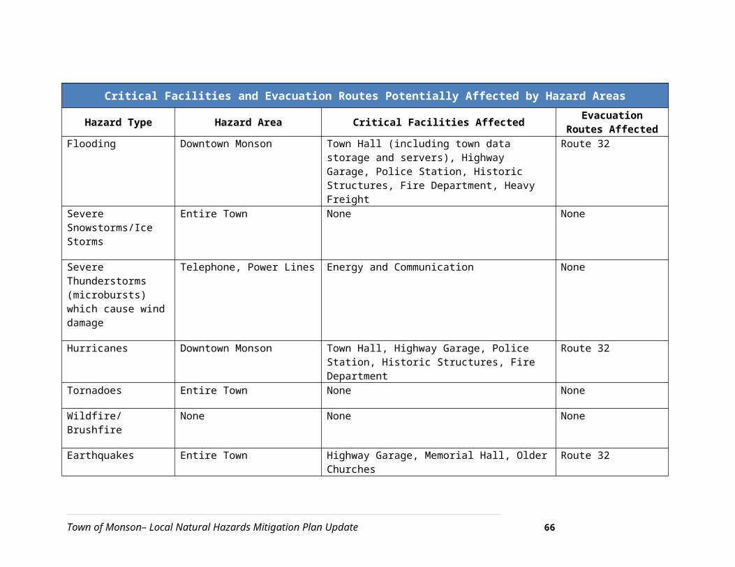
CERTIFICATE OF ADOPTION
TOWN OF MONSON, MASSACHUSETTS
BOARD OF SELECTMEN
A RESOLUTION ADOPTING THE MONSON
HAZARD MITIGATION PLAN UPDATE
WHEREAS, the Town of Monson established a Committee to prepare the Monson Natural Hazards Mitigation Plan Update; and
WHEREAS, several public planning meetings were held between ____ and ____ 2016 regarding the development and review of the Monson Natural Hazards Mitigation Plan Update; and
WHEREAS, the Monson Natural Hazards Mitigation Plan Update contains several potential future projects to mitigate hazard damage in the Town of Monson, and
WHEREAS, a duly-noticed public hearing was held by the Monson Board of Selectmen on __________, 2016 to formally approve and adopt the Monson Natural Hazards Mitigation Plan Update.
NOW, THEREFORE BE IT RESOLVED that the Monson Board of Selectmen adopts the Monson Natural Hazards Mitigation Plan Update.
ADOPTED AND SIGNED this _________, 2016.
___________________________________________________Edward S. Harrison, Chair, Monson Board of Selectmen
___________________________________________________Kathleen C. Norbut, Monson Board of Selectmen
___________________________________________________Richard E. Guertin, Monson Board of Selectmen
ATTEST
Town of Monson– Local Natural Hazards Mitigation Plan Update 71

7: APPENDICES
Appendix A – Technical Resources
1) Agencies
Massachusetts Emergency Management Agency (MEMA)……………………………….………………...508/820-2000Hazard Mitigation Section .......................................................................................................617/626-1356 Federal Emergency Management Agency (FEMA) ..................................................................617/223-4175 MA Regional Planning Commissions:Berkshire Regional Planning Commission (BRPC)…………………………………………………..…………...413/442-1521Cape Cod Commission (CCC)…………………………………...……………………………………………..……….....508/362-3828Central Massachusetts Regional Planning Commission (CMRPC)….…………………………..….….. 508/693-3453Franklin Regional Council of Governments (FRCOG)………………………………………………..…….…...413/774-3167Martha’s Vineyard Commission (MVC)……………………………………………………………………………..…508/693-3453Merrimack Valley Planning Commission (MVPC)…………………………………………..…….……………...978/374-0519Metropolitan Area Planning Council (MAPC)………………..……………………………………………….…...617/451-2770Montachusett Regional Planning Commission (MRPC)…………………………………………………….…978/345-7376Nantucket Planning and Economic Development Commission (NP&EDC)………………………....508/228-7236Northern Middlesex Council of Governments (NMCOG)…………………………………..………………..978/454-8021Old Colony Planning Council (OCPC)……………………………………………………………….………....……...508/583-1833Pioneer Valley Planning Commission (PVPC)……………………………………………………………………...413/781-6045Southeastern Regional Planning and Economic Development District (SRPED.…………………..508/823-1803MA Board of Building Regulations & Standards (BBRS)……………………………………..…………….….617/227-1754MA Coastal Zone Management (CZM)……………………………………………………………………...………..617/626-1200DCR Water Supply Protection….………………………………………………………………….………………..……617/626-1379DCR Waterways………………………..………………………………….….………………………………………………….617/626-1371DCR Office of Dam Safety…………………………………….……………………………………………………….…....508/792-7716DFW Riverways…………………..…………………….………………………………………………………………....…….617/626-1540MA Dept. of Housing & Community Development…………………………………………….…..…………..617/573-1100Woods Hole Oceanographic Institute…………………………………………………………………..………...….508/457-2180UMass-Amherst Cooperative Extension……………………………………………………………………………..413/545-4800National Fire Protection Association (NFPA)…………………………………………………..…………………..617/770-3000New England Disaster Recovery Information X-Change (NEDRIX – an association of private companies & industries involved in disaster recovery planning)…………………………………………………………….781/485-0279MA Board of Library Commissioners………………………………………………………………………………....617/725-1860MA Highway Dept, District 2………………………………………………………………………….…………………..413/582-0599MA Division of Marine Fisheries………………………………………………………………………………..………617/626-1520MA Division of Capital & Asset Management (DCAM)…………………………………….………….………617/727-4050University of Massachusetts/Amherst………………………………….....…………………………………….....413/545-0111Natural Resources Conservation Services (NRCS)…………………………………………………….………...413/253-4350MA Historical Commission……………………………………………………………………………………….………...617/727-8470U.S. Army Corps of Engineers…………………………………………………………………………….……………….978/318-8502Northeast States Emergency Consortium, Inc. (NESEC)...........................................................781/224-9876National Oceanic and Atmospheric Administration: National Weather Service………………….508/824-5116US Department of the Interior: US Fish and Wildlife Service ..................................................413/253-8200
Town of Monson– Local Natural Hazards Mitigation Plan Update 72

US Geological Survey...............................................................................................................508/490-5000
2) Mitigation Funding Resources
404 Hazard Mitigation Grant Program (HMGP) ………………..……….…...MA Emergency Management Agency406 Public Assistance and Hazard Mitigation .....................................MA Emergency Management AgencyCommunity Development Block Grant (CDBG)……...................................................DHCD, also refer to RPCDam Safety Program................................................................MA Division of Conservation and RecreationDisaster Preparedness Improvement Grant (DPIG) …………………..…….MA Emergency Management AgencyEmergency Generators Program by NESEC‡ ......................................MA Emergency Management AgencyEmergency Watershed Protection (EWP) Program..........................USDA, Natural Resources ConservationService Flood Mitigation Assistance Program (FMAP)……………………..MA Emergency Management AgencyFlood Plain Management Services (FPMS).........................................................US Army Corps of EngineersMitigation Assistance Planning (MAP)................................................MA Emergency Management AgencyMutual Aid for Public Works..........Western Massachusetts Regional Homeland Security Advisory CouncilNational Flood Insurance Program (NFIP) † …….……………………………..MA Emergency Management AgencyPower of Prevention Grant by NESEC‡ ..............................................MA Emergency Management AgencyRoadway Repair & Maintenance Program(s)......................................Massachusetts Highway DepartmentSection 14 Emergency Stream Bank Erosion & Shoreline Protection ...............US Army Corps of EngineersSection 103 Beach Erosion…………………………………….…………………….………….......US Army Corps of EngineersSection 205 Flood Damage Reduction…………………………………..…..………………....US Army Corps of EngineersSection 208 Snagging and Clearing ………………………………….…....…………............US Army Corps of EngineersShoreline Protection Program………………………………………MA Department of Conservation and RecreationVarious Forest and Lands Program(s)....................................MA Department of Environmental ProtectionWetlands Programs ...............................................................MA Department of Environmental Protection
‡NESEC – Northeast States Emergency Consortium, Inc. is a 501(c)(3), not-for-profit natural disaster, multi-hazard mitigation and emergency management organization located in Wakefield, Massachusetts. Please, contact NESEC for more information.
† Note regarding National Flood Insurance Program (NFIP) and Community Rating System (CRS): The National Flood Insurance Program has developed suggested floodplain management activities for those communities who wish to more thoroughly manage or reduce the impact of flooding in their jurisdiction. Through use of a rating system (CRS rating), a community’s floodplain management efforts can be evaluated for effectiveness. The rating, which indicates an above average floodplain management effort, is then factored into the premium cost for flood insurance policies sold in the community. The higher the rating achieved in that community, the greater the reduction in flood insurance premium costs for local property owners. MEMA can provide additional information regarding participation in the NFIP-CRS Program.
Town of Monson– Local Natural Hazards Mitigation Plan Update 73

3) Internet Resources
Sponsor Internet Address Summary of Contents
Natural Hazards
Research Center, U.
of Colorado
http://www.colorado.edu/litbase/hazards/
Searchable database of
references and links to many
disaster-related websites.
Atlantic Hurricane
Tracking Data by Year
http://wxp.eas.purdue.edu/hurricane
Hurricane track maps for
each year, 1886 – 1996
National Emergency
Management
Association
http://nemaweb.org
Association of state
emergency management
directors; list of mitigation
projects.
NASA – Goddard
Space Flight Center
“Disaster Finder:
http://www.gsfc.nasa.gov/ndrd/dis aster/
Searchable database of sites
that encompass a wide range
of natural disasters.
NASA Natural
Disaster Reference
Database
http://ltpwww.gsfc.nasa.gov/ndrd/main/html Searchable database of
worldwide natural disasters.
U.S. State & Local
Gateway
http://www.statelocal.gov/ General information through
the federal-state partnership.
National Weather
Service
http://nws.noaa.gov/Central page for National
Weather Warnings, updated
every 60 seconds.
USGS Real Time
Hydrologic Data
http://h20.usgs.gov/public/realtime.htmlProvisional hydrological data
Dartmouth Flood
Observatory
http://www.dartmouth.edu/artsci/g
eog/floods/
Observations of flooding
situations.
FEMA, National Flood
Insurance Program,
Community Status
Book
http://www.fema.gov/fema/csb.html Searchable site for access of
Community Status Books
Florida State
University Atlantic
Hurricane Site
http://www.met.fsu.edu/explores/tropical.html
Tracking and NWS warnings
for Atlantic Hurricanes and
other links
The Tornado Project http://www.tornadoroject.com/ Information on tornadoes,
Town of Monson– Local Natural Hazards Mitigation Plan Update 74

Sponsor Internet Address Summary of Contents
Online including details of recent
impacts.
National Severe
Storms Laboratory
http://www.nssl.uoknor.edu/ Information about and
tracking of severe storms.
Independent
Insurance Agents of
America IIAA Natural
Disaster Risk Map
http://www.iiaa.iix.com/ndcmap.htmlA multi-disaster risk map.
Earth Satellite
Corporation
http://www.earthsat.com/ Flood risk maps searchable
by state.
USDA Forest Service
Web
http://www.fs.fed.us/land Information on forest fires
and land management.
Town of Monson– Local Natural Hazards Mitigation Plan Update 75

Appendix B – Documentation of the Planning Process
Media Organizations Sent Press Releases
Media Organization Address Town StateZip Code
African American Point of View 688 Boston Road Springfield MA 01119Agawam Advertiser News 23 Southwick Street Feeding Hills MA 01030Amherst Bulletin 115 Conz Street Northampton MA 01060Belchertown Sentinel 1 Main Street Belchertown MA 01007Berkshire Eagle 75 South Church Street Pittsfield MA 01202Brattleboro Reformer 62 Black Mountain Rd. Brattleboro VT 05301CBS 3 Springfield One Monarch Place Springfield MA 01144Chicopee Register 380 Union Street West Springfield MA 01089CommonWealth Magazine 18 Tremont Street Boston MA 02108Country Journal 5 Main Street Huntington MA 01050Daily Hampshire Gazette 115 Conz Street Northampton MA 01060El Sol Latino P.O. Box 572 Amherst MA 01004Going Green PO Box 1367 Greenfield MA 01302Hilltown Families P.O. Box 98 West Chesterfield MA 01084Holyoke Sun 138 College Street South Hadley MA 01075Journal Register 24 Water Street Palmer MA 01069La Voz Hispana 133 Maple Street #201 Springfield MA 01105Ludlow Register 24 Water Street Palmer MA 01069Massachusetts Municipal Association One Winthrop Street Boston MA 02110Quaboag Current 80 Main Street Ware MA 01082Recorder 14 Hope Street Greenfield MA 01302Reminder 280 N. Main Street East Longmeadow MA 01028Southwick Suffield News 23 Southwick Street Feeding Hills MA 01030State House News Service State House Boston MA 02133Tantasqua Town Common 80 Main Street Ware MA 01082The Longmeadow News 62 School Street Westfield MA 01085The Republican 1860 Main Street Springfield MA 01102
Town of Monson– Local Natural Hazards Mitigation Plan Update 76

The Westfield News 62 School Street Westfield MA 01085Town Reminder 138 College Street South Hadley MA 01075Urban Compass 83 Girard Avenue Hartford CT 06105Valley Advocate 115 Conz Street Northampton MA 01061Vocero Hispano 335 Chandler Street Worcester MA 01602WAMC Northeast Public Radio 1215 Wilbraham Road Springfield MA 01119Ware River News 80 Main Street Ware MA 01082West Springfield Record P.O. Box 357 West Springfield MA 01098WFCR-Public Radio 131 County Circle Amherst MA 01003WGBY-Public TV 44 Hampden Street Springfield MA 01103WGGB ABC40/FOX 6 News 1300 Liberty Street Springfield MA 01104WHMP-FM 15 Hampton Avenue Northampton MA 01060Wilbraham-Hampden Times 2341 Boston Road Wilbraham MA 01095Worcester Telegram & Gazette 20 Franklin Street Worcester MA 01615WRNX/WHYN/WPKR Radio 1331 Main Street Springfield MA 01103WWLP-TV 22 PO Box 2210 Springfield MA 01102
Town of Monson– Local Natural Hazards Mitigation Plan Update 77

Appendix C – List of Acronyms
FEMA Federal Emergency Management AgencyMEMA Massachusetts Emergency Management AgencyPVPC Pioneer Valley Planning CommissionEPA Environmental Protection AgencyDEP Massachusetts’ Department of Environmental ProtectionNWS National Weather ServiceHMGP Hazard Mitigation Grant ProgramFMA Flood Mitigation Assistance ProgramSFHA Special Flood Hazard AreaCIS Community Information SystemDCR Massachusetts Department of Conservation and RecreationFERC Federal Energy Regulatory CommissionTRI Toxics Release InventoryFIRM Flood Insurance Rate MapNFIP National Flood Insurance ProgramCRS Community Rating SystemBOS Board of SelectmenDPW Department of Public WorksLEPC Local Emergency Planning CommitteeEMD Emergency Management DirectorCon Com Conservation CommissionAg Com Agricultural CommissionEOC Emergency Operations CenterCEM Plan Comprehensive Emergency Management PlanEMA Emergency Management AgencyRACES Radio Amateur Civil Emergency ServiceWMECO Western Massachusetts Electric CompanyHAZMAT Hazardous Materials
Town of Monson– Local Natural Hazards Mitigation Plan Update 78

Appendix D – Past & Potential Hazards/Critical Facilities Map
Town of Monson– Local Natural Hazards Mitigation Plan Update 79
Appendix E – Development Regulations and Policies for Mitigating Hazards in Monson
Flooding
Management Plans
The Comprehensive Emergency Management (CEM) Plan for Monson lists the following generic mitigation measures for flood planning:
1. Identify areas in the community that are flood prone and define methods to minimize the risk. Review National Flood Insurance Maps.
2. Disseminate emergency public information and instructions concerning flood preparedness and safety.
3. Community leaders should ensure that their community is enrolled in the National Flood Insurance Program.
4. Strict adherence should be paid to land use and building codes (e.g. Wetlands Protection Act) and new construction should not be built in flood-prone areas.
5. Ensure that flood control works are in good operating condition at all times.6. Natural water storage areas should be preserved.7. Maintain plans for managing all flood emergency response activities including
addressing potentially hazardous dams.
The Comprehensive Emergency Management (CEM) Plan for Monson lists the following generic preparedness and response measures for floods:
Place EOC personnel on standby during stage of flood ‘watch’ and monitor NWS/New England River Forecast Center reports.
Ensure that public warning systems are working properly and broadcast any information that is needed at this time.
Review mutual aid agreements. Monitor levels of local bodies of water. Arrange for all evacuation and sheltering procedures to be ready for activation when
needed. Carry out, or assist in carrying out, needed flood-proofing measures such as sand bag
placement, etc. Regulate operation of flood control works such as flood gates. Notify all Emergency Management related groups that will assist with flood response
activities to be ready in case of flood ‘warning’.
Evacuation Options
Town of Monson– Local Natural Hazards Mitigation Plan Update 80

The 100-year flood zone covers mostly narrow bands of level floodplain land along the Quaboag River (which runs along the town Monson/Palmer Town Line), the Chicopee Brook (which runs north-south along Palmer Road), Twelvemile Brook and Maxwell Brook (located in the western portion of Monson) and the Conant Brook Reservoir and the Vinica Brook (both located in south eastern Monson). According to the Monson CEM Plan, local officials have stated that there are local shelters available for flooding victims, including people with Special, non-institutional needs. These are Quarry Hill Street, the Monson Senior Center, the Granite Valley Middle School, various school department buildings, the Monson Developmental Center, the Palmer Senior High School (located in the neighboring town of Palmer), the Monson Fire Station and the Monson Senior High School. Approximately six properties would be impacted by a 100-yr.flood. Emergency management personnel should assess existing floodplain and dam failure data to determine an appropriate evacuation plan.
In addition, Monson has 22 bridges situated either in or near the 100-year floodplain, which could make evacuation efforts as a result of dam failure more difficult. Some of the roads that residents would most likely take to reach safety travel through flood-affected areas.
Flood Control Structures
Conant Brook Dam: This approximately 300-acre parcel of land is owned by the U.S. Army Corps of Engineers for flood control purposes. The area includes a rare kettle pond. The floodplain is currently dry with only a small shallow silt pool. The area overall is suitable for hiking and horseback riding.
Land Use Regulations that Mitigate Impacts from Flooding9
The Town of Monson has adopted several land use regulations that serve to limit or regulate development in floodplains, to manage stormwater runoff, and to protect groundwater and wetland resources, the latter of which often provide important flood storage capacity. These regulations are summarized below and their effectiveness evaluated in Table 4-1.
Subdivision Rules and Regulations
Monson’s most recent draft of its Subdivision Rules and Regulations (1983) which govern the subdivision of land were adopted for the purpose of “protecting the safety, convenience and welfare of the inhabitants of the cities and towns in which it is, or may hereafter be, put in effect by regulating the laying out and construction of ways in subdivisions providing access to the several lots therein, but which have not become public ways, and ensuring sanitary conditions in subdivisions and in proper cases parks and open areas. The powers of the
9 All bulleted items and direct quotes in the Monson Local Natural Hazards Mitigation Plan are taken from the Town of Monson’s zoning bylaw and subdivision regulations. Other references to those documents contained herein are paraphrases of the same.
Town of Monson– Local Natural Hazards Mitigation Plan Update 81

planning board and of a board of appeals under the subdivision control law shall be exercised with due regard for the provision of adequate access to all of the lots in a subdivision by ways that will be safe and convenient for travel; for lessening congestion in such ways and in the adjacent public ways; for reducing danger to life and limb In the operation of motor vehicles; for securing safety in the case of fire, flood, panic and other emergencies; for insuring compliance with the applicable zoning ordinances or by-laws; for securing adequate provision for water, sewerage, drainage and other requirements where necessary in a subdivision; and for coordinating the ways in a subdivision with each other and with the public ways in the city or town in which it is located and with the ways in neighboring subdivisions. It is the intent of the subdivision control law that any subdivision plan filed with the planning board shall receive the approval of such board if said plan conforms to the recommendation of the board of health and to the reasonable rules and regulations of the planning board pertaining to subdivisions of land; provided, however, that such board may, when appropriate, waive, as provided for in section eighty-one R, such portions of the rules and regulations as is deemed advisable.” The Subdivision Rules and Regulations contain several provisions that mitigate the potential for, and impact of, flooding, including:
Section 5.3. [Definitive plan] Contents. Requires the proponent, in part, to identify:
o 5.3.4. Major site features, such as…swamps, flood plains, historic features, and wooded areas; the plan shall identify which of the above shall remain undisturbed
o 5.3.5. Location of natural waterways and waterbodies within and adjacent to the subdivision;
o 5.3.15.b. Drainage details for catch basins, man-holes, inwalls and all other components or features, with specific references to the appropriate sections of the State Construction Standards;
o 5.3.15.c. Drainage trench or waterway relocation section;
o 5.3.16.b. Storm Drainage System including manholes, pipes, culverts, catch basins and appurtenant structures;
Section 8.5. Environmental Impact. This section shall deal separately with both short-term and long-term impacts. A narrative statement shall be submitted, documenting all mitigative measures taken to:…:
Section 8.50 Prevent Surface Water Contamination, changes in surface water level, or both.
Section 8.51 Prevent Groundwater Contamination, changes in groundwater level, or both.
Section 8.52 Maintain Slope Stability.
Town of Monson– Local Natural Hazards Mitigation Plan Update 82

Section 8.53 Prevent erosion, sedimentation, or other instability in soils or vegetative cover.
Section 8.57 Protect wetlands and floodplains, and ensure compliance with the Wetlands Protection Act (Sections 40 and 40A of Chapter 131 of the General Laws).
o Section 7.32 Drainage and Drainage Structures
a. Culverts to be installed to carry runoff from existing streams shall be designed to satisfy requirements of a hundred-year storm.
b. Proposed culverts and ditches to be installed for street drainage shall be designed to satisfy requirements of a twenty five-year storm.
o Section 7.33 Catch Basins and Manholes
Adequate disposal of surface water shall be provided for in a manner satisfactory to the Planning Board, and shall address runoff from the proposed subdivision. Such system may include a system of storm drains, culverts, ditches, underdrains, detention basins, drywells, and related installations, including catch basins, gutters and manholes, and shall be designed and installed to provide adequate disposal of surface water, including control of erosion, flooding, storm water management and standing water from or in the subdivision and adjacent lands. A catch basin to manhole system of drainage is required.
When development of an area will increase runoff to downstream properties, a detention area shall be constructed. Such detention area will be designed to handle the 100-year storm without increasing downstream runoff above pre-construction conditions, and such size shall be determined by using the flood routing procedure as described in the U.S.D.A. Soil Conservation Service Technical Release No. 55. Storm Water calculations shall be prepared by a Registered Professional Engineer using two methods of calculations. One method shall be as described in U.S.D.A. Soil Conservation Service Technical Release No. 55.
o Section 7.33.2 Piped Systems
e. No open water body or pond shall be filled in, and no wet or swampy area shall be filled in unless approval has been obtained in accordance with Chapter 131 of the Massachusetts General Laws.
f. Where open stream channels exist within a subdivision, adequate provision shall be made for properly maintaining them or for properly enclosing them, if absolutely necessary. It is the Town's Intent to preserve and maintain the natural features of such streams and any development should be planned accordingly.
o Section 7.34
Town of Monson– Local Natural Hazards Mitigation Plan Update 83

a. In order to replicate the flood control value of undisturbed lands, provide compensatory storage of storm water runoff, and comply with the Town of Monson's Zoning Bylaws, the Town of Monson may allow the construction of storm water detention basins provided that:
5. their location is not in an area such that the sudden release of water, due to failure, would result in loss of life, injury to persons, damage to residences or buildings or cause interruptions of use or service of public utilities;
o Section 7.34.2 Contents
The following information shall be required to be submitted as part of the Definitive Plan:
b. Water courses, ponds, marshes, flood plains, rock outcrop, and other significant natural features within 100 feet of the proposed high water mark (as determined by the 100-year storm frequency);
c. A drainage area map outlining the watershed area; the map shall show the watershed boundary; the drainage pattern; location of bridges, culverts and other structures that affect the flow of water; location of roads, buildings, property lines and fences or walls; and a north arrow.
e. Drainage calculations for proposed and existing conditions, done for a minimum 25 year and 100-year storms. Critical volume calculations should be checked by an independent alternate method using both short duration/high intensity and long duration storms.
j. All drainage design Information, drawings and runoff calculations must be prepared, signed, dated, and stamped by a Massachusetts Registered Professional Engineer using standard acceptable engineering methods. The runoff calculations should be based on soil cover conditions expected to prevail during the anticipated effective life of the structure.
A 100-year design frequency storm is required for all storm water detention basins.
Section 5.1.5. Stormwater Runoff
In those areas not served by storm drains, the rate of surface water run-off from a site shall not increase after construction. If needed to meet this requirement and to maximize groundwater recharge, increased runoff from impervious surfaces shall be recharged on site by being diverted to vegetated surfaces for infiltration or through the use of detention ponds. Dry wells shall be used only where other methods are and shall require oil, grease and sediment traps to facilitate removal of contaminants.
o 5.51 Water Supply Protection District,
Town of Monson– Local Natural Hazards Mitigation Plan Update 84

Any portion of a proposed subdivision which lies within the limits of the Water Supply Protection District shall conform to the requirements of said district as stated in the appropriate section of the Monson Zoning Bylaw
7.50 General Standards
1. All public and private sewers, surface water drains, water and gas pipes, electric, telephone and Cable TV lines, together with their appropriate underground structures, within the street right-of-way, shall be placed underground at the discretion of the Board.
Driveway Standards, From the “Definitions” Section
That portion of a parcel of land on private property designed by the property owner as the vehicle access from a street to parking or garage areas on private property. A driveway shall have a maximum grades of 12% for a distance of twenty-five (25) feet from the street line and shall be no closer than ten (10) feet from any abutting side property line. The driveway access shall occur across the minimum frontage required in the Zoning District in which the frontage is located. Section 4600.
Easements.
Section 4620. Where a subdivision is traversed by a water course, drainage way, stream, or channel, the Board may require that a storm water easement or drainage right-of-way be provided of adequate width to provide for free flow of water in its natural course, for construction, or for other necessary purposes.
o Section 5.52 Wetlands Protection In accordance with Chapter 131, Section 40 of the General Laws, no person shall remove, fill, dredge or alter any bank, beach, dune, flat, marsh, meadow or swamp bordering on any existing creek, river, stream, pond, lake or any land under said waters or subject to flooding without filing written notice of intention to perform said work with the local Conservation Commission and/or Department of Environmental Quality Engineering.
Section 5.61 [Role of Conservation Commission] At the time of the filing of the Definitive Plan with the Planning Board, one (1) copy shall be filed by the applicant with the Conservation Commission for review. The making of a report by the Conservation Commission to the Planning Board concerning a proposed Definitive Plan shall not be treated so, nor deemed to be approval of, an Order of Conditions or any other approval provided by the Wetlands Protection Act or regulations issued thereunder, or by any local wetlands bylaw; and, a request by the Planning Board for such a report shall not be treated as, nor deemed to be, a Notice of Intent or any other application provided by the Wetlands Protection Act or regulations issued thereunder, or by any local wetlands bylaw.
Town of Monson– Local Natural Hazards Mitigation Plan Update 85

Monson Zoning By-Laws
The Town of Monson has established a set of bylaws designed in part to “to promote the general welfare of the Town of Monson, to protect the health and safety of its inhabitants, to encourage the most appropriate use of land throughout the town, and to increase the amenities of the town, all as authorized by, but not limited to, the provisions of the Zoning Act, G.L. c. 40A, as amended, and Section 2A of 1975 Mass. Acts 808.” The Zoning By-Laws include several provisions that mitigate the potential for flooding, including:
Environmental Controls
Section 5.1.6. Erosion Control The landscape shall be preserved in its natural state, insofar as practical, by minimizing tree removal and any grade changes shall be in keeping with the general appearance of neighboring developed areas. These regulations are intended to supplement the Wetlands Protection Act. Erosion of soil and sedimentation of streams and water bodies shall be minimized by using the following erosion control practices:
1. The duration of exposure of disturbed areas due to stripping of vegetation, soil removal, and regarding shall be kept to a minimum.
2. During construction, temporary vegetation and/or mulching shall be used to protect exposed areas from erosion. Until a disturbed area is permanently stabilized, sediment in runoff water shall be trapped by using staked hay bales or sedimentation traps.
3. Permanent erosion control and vegetative measures shall be in accordance with the erosion/sedimentation/vegetative practices recommended by the Soil Conservation Service.
4. All slopes exceeding 15% resulting from site grading shall be either covered with 4 inches of topsoil and planted with a vegetative cover sufficient to prevent erosion or be stabilized by a retaining wall. 5. Dust control shall be used during grading operations if the grading is to occur within 200 feet of an occupied residence of place of business.. Dust control methods may consist of grading fine soils on calm days only or dampening the ground with water.
6.13 Protection of Natural Features
All natural features, such as large trees, watercourses, wetlands, scenic points, historic spots, and similar community assets which will add attractiveness and value to the property shall be preserved. (Six (6) inches of top soil shall be replaced on all disturbed earth within the subdivision.)
6.6 Earth Removal and Filling of Land Bylaw
Town of Monson– Local Natural Hazards Mitigation Plan Update 86

6.6 [Applicability] In any zoning district, removal or addition of soil, loam, sand, gravel, clay, sod, quarried stone, or other mineral deposit shall not be permitted except by special permit from the Zoning Board of Appeals.
Scope of Authority
Section 6.6.7.4. Filling of land in conjunction with the installation of an approved Title V septic system provided the fill is not placed closer than (10) ten feet to the side and rear property lines and does not increase the stormwater run off from the property. Provide a plan, prepared by a registered engineer, showing compliance with these provisions.
Section 6.6.7.5. Filling of land in conjunction with the construction and landscaping of a single family home, provided the grade is not raised by more than (4) four feet and the fill is not placed closed than (10) ten feet to the side and rear property lines and does not increase the stormwater run off from the property. Provide a plan, prepared by a registered engineer, showing compliance with these provisions.
Section 7.4 Site Plan Review
7.4.2. Purpose. The purpose of site plan approval is to further the purposes of this Bylaw and to ensure that new development is designed in a manner which reasonably protects visual and environmental qualities and property values of the Town, and to assure adequate drainage of surface water and safe vehicular access.
7.4.4 Required Site Plan Contents. All site plans shall show:
2. Existing and proposed topography including contours, the location of wetlands, streams, waterbodies, drainage swales, areas subject to flooding, and unique natural land features;
7.4.6 Site Plan Review Criteria. The following will be taken into consideration:
2. The development shall be integrated into the existing terrain and surrounding landscape, and shall be designed to protect abutting properties and community amenities. Building sites shall, to the extent feasible: (a) minimize use of wetlands, steep slopes, floodplains, hilltops: (b) minimize obstruction of scenic views from publicly accessible locations; (c) preserve unique natural or historical features; (d) minimize tree, vegetation and soil removal and grade changes; and (e) maximize open space retention; and (f) screen objectionable features from neighboring properties and roadways.
Town of Monson– Local Natural Hazards Mitigation Plan Update 87
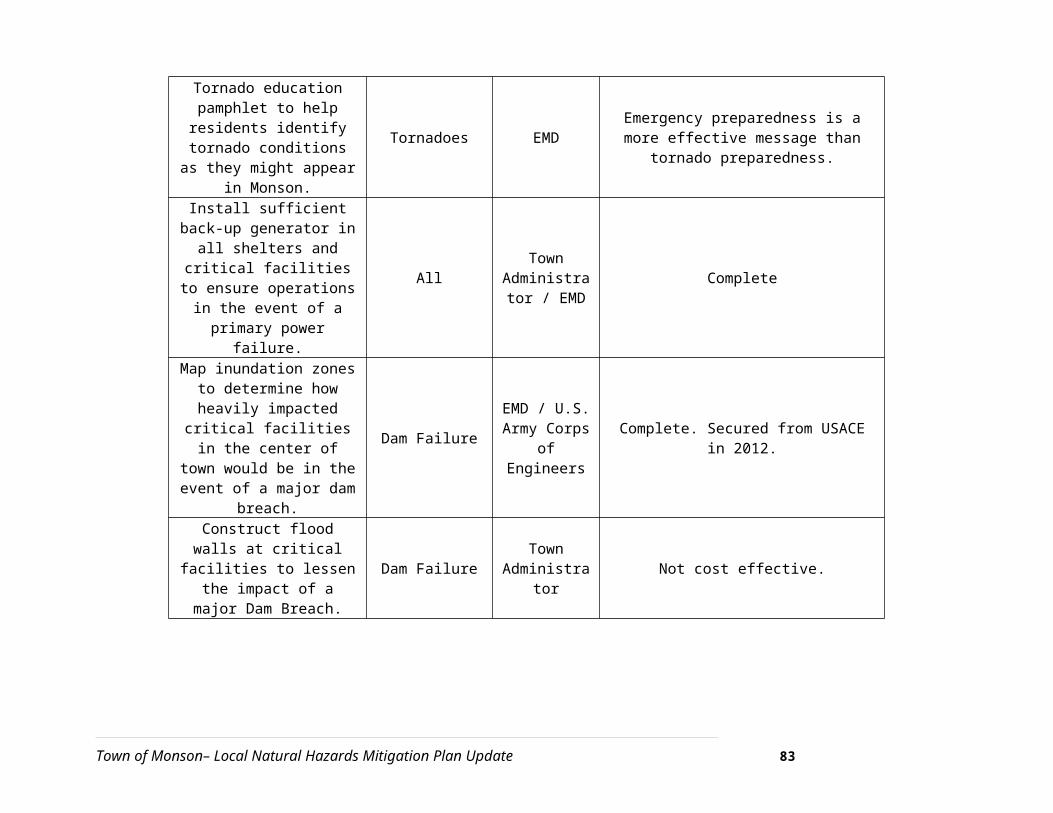
Section 4.1. Floodplain District Regulations
Section 4.1.1 Purpose. 1. To provide that lands in the Town of Monson subject to seasonal or periodic flooding described hereinafter shall not be used for residence or other purposes in such manner as to endanger the health or safety of the occupant thereof.
2. To protect, preserve and maintain the water table and water recharge, areas within the Town so as to preserve present and potential water supplies for the public health and safety of the Town of Monson.
3. To assure the continuation of the natural flow pattern of the water course(s) within the Town of Monson in order to provide adequate and safe floodwater storage capacity to protect persons and property against the hazards of flood inundation.
4.1.2 [Scope of Authority]. The Floodplain District is an overlay district and shall be superimposed on the other districts established by this Bylaw. All regulations of the Monson Zoning Bylaw applicable to such underlying districts shall remain in effect, except that where the Floodplain District imposes additional regulations, such regulations shall prevail.
1. The Floodplain District is defined as all lands designated as Zone A or Zone A 1-30 on the Town of Monson Flood Insurance Rate Maps (FIRM) panels 250145-0008-9, 0015-0019, 0035 and 0040, of plans on file with the Town Clerk or as determined by a registered professional engineer and approved by the Floodplain Administrator.
2. The floodway boundaries are delineated on the Monson Flood Boundary and Floodway Map (FBFM) panel 250145-0001-0045 dated June 1981 and modified by subsequent changes or as determined by a registered professional engineer and approved by the Floodplain Administrator.
4.1.4 [Restrictions]
In the Floodplain District no new building shall be erected or constructed, and no existing structure shall be altered, enlarged or moved; no dumping, filling or earth transfer or relocation shall be permitted; nor shall any land, building or structure be used for any purposes
4.1.7 Prohibited Uses. The following uses are specifically prohibited and may not be allowed by special permit:
1. Solid waste landfills, junkyards and dumps.
Town of Monson– Local Natural Hazards Mitigation Plan Update 88

2. Business and industrial uses, not agricultural, which manufacture, use process, store or dispose of hazardous materials or wastes as a principal activity, including but not limited to metal plating, chemical manufacturing, wood preserving, furniture stripping, dry cleaning and auto body repair.
3. The outdoor storage of salt, other de-icing chemicals, pesticides or herbicides shall be prohibited without suitable overhead protection from weather. All storage shall be within an impervious containment area.
4. Draining, dredging, excavation or disposal of soil or mineral substances, except as necessary for permitted uses or uses allowed by special permit, as specified in the Earth Removal Bylaw, Section 6.6.
Section 2.3 Reserved Land District
Section 2.3.1 Purpose. 2.3.1 Purpose. The purpose of the R.L. Zone District is to conserve lands in generally public or semi-public ownership, and to limit the location and use of land and buildings under private ownership for trade, industry, agriculture, and residential purposes, but this section shall in no way limit nor prohibit the use of land or buildings for any church or other religious purpose, or for any educational purpose, as provided in Section 2 of Chapter 40A of the General Laws of Massachusetts.Section 2.4.2-3. [Restrictions]
2.3.2 Permitted Uses. Any use which is permitted in the charter of the owner, provided that any industrial, business, and/or residential uses shall be limited to, and used exclusively by and for the requirements of the owner.
2.3.3 Prohibited Uses. Any industrial, business and/or residential use under private ownership that does not furnish a public service or utility…
Section 4.2 Water Supply Protection District
Section 4.2.1. Purpose. a. promote the health, safety and general welfare of the community by ensuring an adequate quality and quantity of drinking water for the residents, institutions and businesses of the Town of Monson. b. preserve and protect existing and potential sources of drinking water supplies; c. conserve the natural resources of the town and; d. prevent temporary and permanent contamination of the environment.
Section 4.2.2. Scope of Authority:
The Water Supply Protection District is an overlay district superimposed on the zoning districts. This overlay district shall be apply to all new construction, reconstruction, or expansion of existing buildings and new or expanded uses. Applicable activities/uses in a portion of one of
Town of Monson– Local Natural Hazards Mitigation Plan Update 89

the\ underlying zoning districts which fall within the Water Supply Protection District must additionally comply with the requirements of this district. Uses prohibited in the underlying zoning districts shall not be permitted in the Water Supply Protection District. Land lying within a horizontal distance of fifty (50) feet on each side of the bank and/or edge of each and every “Minor Stream” in the Town of Monson…
Section 4.2.4. Establishment and Delineation of Groundwater Protection District
For the purposes of this district, there are hereby established within the town certain groundwater protection areas, consisting of aquifers or recharge areas which are delineated on a map. This map is at a scale of 1 inch to 12,000 feet and is entitled "Zone II Map, Bethany, Palmer & Bunyan Road Wells, Town of Monson" dated October 2001. This map is hereby made a part of the town zoning bylaw and is on file in the Office of the Town Clerk.
Section 4.2.6. A. Permittedvi. residential development, subject to [4.2] Section B (prohibited uses) and [4.2] Section C (special permitted uses)10;
Section 4.2.6.B Prohibited Usesii. Automobile graveyards and junkyards, as defined in MGL c. 140B, sec. 1;
Section 4.2.6.C Uses and Activities Requiring a Special Permit
iii. any use that will render impervious more than 15% or 2500 square feet of any lot, whichever is greater. A system for groundwater recharge must be provided, which does not degrade groundwater quality. For non-residential uses, recharge shall be by storm water infiltration basins or similar system covered with natural vegetation and dry wells shall be used only where other methods are infeasible. For all non-residential uses, all such basins and wells shall be preceded by oil, grease and sediment traps to facilitate removal of contamination. Any and all recharge areas shall be permanently maintained in full working order by the owner.
Section 4.3 Scenic District
4.3.1 Purpose
1. Create, preserve and enhance areas considered to be of natural scenic beauty including wooded canyons, ridges and fine vistas or viewsheds. 2. Regulate removal, filling, excavation or alteration of land within a scenic area, which is likely to have a significant adverse effect on watershed resources or natural scenic qualities.
4.3.2 Scope of Authority. The Scenic District is an overlay district and shall be superimposed on the other districts established by this Bylaw. All regulations of the Monson Zoning Bylaw
10 Section A and B of this Section 4.2 mostly deal with restrictions on toxic substances, petroleum, municipal waste treatment facilities and road salt storage.
Town of Monson– Local Natural Hazards Mitigation Plan Update 90

applicable to such underlying districts shall remain in effect, except that where the Scenic District imposes additional regulations, such regulations shall prevail.
4.3.3 Designated Area. The Scenic District Bylaw shall be applied to areas of scenic value as designated on the overlay map entitled "Scenic District, Town of Monson" on file with the Town Clerk.
4.3.6 Uses Not Permitted. The following uses are not permitted in the Scenic District:
1. Surface mining; 2. Pipelines located above ground; 3. Power plants; 4. Refineries or oil or gas tanks storing over 5,000 gallons above ground; 5. Auto sales, storage, or salvage yards; 6. Solid waste disposal sites;
7. Wrecking yards.
4.3.10.1 Scenic District Review Criteria
1. Scenic District review should ensure that when man-made structures are built in scenic areas, they are sensitively related to the natural setting and that special consideration has been given to their siting and design.
6.4 Open Space Communities
Section 6.4.3.1. Purpose. 1. allow for greater flexibility and creativity in the design of residential subdivisions, provided that the overall density of the development is no greater than what is normally allowed in the district;
2. encourage the permanent preservation of open space, agricultural lands and other natural resources;
3. maintain the traditional New England rural character and land use pattern in which small villages contrast with open space and farmlands;
4. facilitate the construction and maintenance of streets, utilities and public services in a more economical and efficient manner;
5. encourage a less sprawling form of development that consumes less open land.
Section 6.4.4. [Applicability]. 1. The development shall include single-family dwellings only.
Town of Monson– Local Natural Hazards Mitigation Plan Update 91

2. The minimum land required for a cluster development shall be ten (10) acres and the parcel shall be held in single ownership or control at the time of application.
3. Each lot shall have adequate access on a public or private way.
4. Each lot shall be of a size and shape to provide a building site, which shall be in harmony with the natural terrain and other features of the land.
5. There shall be an adequate, safe, and convenient arrangement of pedestrian circulation, facilities, roadways, driveways, and parking.
6. The site plan shall identify the location and extent of all wetlands on the site as determined by the Conservation Commission under the Massachusetts Wetlands Protection Act, M.G.L. Chapter 131, Section 40.
Section 6.4.6 and 6.4.7 Applicable Scope of Authority
Section 6.4.6.1 A one-family detached dwelling, or lawful accessory building, may be constructed on a lot with an Open Space Community development although such lot has less area and frontage than normally required, as herein specified.
Section 6.4.6.2.The maximum number of dwelling units permitted in an open space community shall be calculated based upon 1.5 units per acre for the net developable acreage remaining once the area of all wetlands, all areas unsuitable for on-site sewage disposal and lands with slopes greater than twenty-five (25) percent have been subtracted from the total acreage of the property.
Section 6.4.6.3. Under the supervision of the Conservation Commission and in accordance with the provisions of the Wetlands Protection Act, M.G.L. Chapter 131, Section 40, all wetlands shall be identified, and their area subtracted from the net developable acreage of the total parcel.
6.4.6.5. Lot sizes shall not be less than one-half (50%) of the minimum lot size normally required in the district, or thirty thousand (30,000) square feet per lot.
6.4.7.3. The following lands shall not be used to meet the common open space requirements:
(a) Lands within the floodplain district;
(b) Lands identified as wetlands in accordance with the Massachusetts Wetlands Protection Act;
(c) Lands with slopes greater than twenty-five percent (25%)
Town of Monson– Local Natural Hazards Mitigation Plan Update 92
River and Stream Protection
The Town of Monson follows the standards established by the Wetlands Protection Act, which protects water bodies and wetlands through the town Conservation Commission. The Town also has instituted its Watershed Protection District, an overlay district that provides restrictions solid wastes, hazardous liquids and petroleum products.
Monson Open Space and Recreation Plan
Recent efforts by the Town of Monson Conservation Commission and others have resulted in the creation of municipal plans that are useful for flood hazard mitigation purposes. In 1999, the town completed its Open Space and Recreation Plan. The intent of the document is not to address hazard mitigation or flood control in a direct or comprehensive way; however, it inventories the natural features and environments in the town, many of which, such as wetlands, aquifer recharge areas, farms, rivers, streams, and brooks, contain floodplain, dam failure inundation or localized flooding areas.
The plan highlights the importance of balancing future development with the preservation of the community’s natural and scenic resources. The preservation of open space and farmland will provide flood storage capacity, which reduces the amount of impervious surfaces in an area, as well as other benefits not directly related to natural hazard mitigation. Monson’s OSRP is current until November 2010, and a plan should be in place to guarantee that the Town remains eligible for state grants tied to a current and approved OSRP.
National Flood Insurance Program
The Town of Monson participates in the National Flood Insurance Program. As of 2006, there were six policies in effect in Monson for a total of $857,900 worth of insurance. The town is not a member of the Community Rating System, which entitles policyholders to a discount on flood insurance premiums. The CRS ranking is based on the steps that a town has taken to control flood losses.
The Community Rating System reduces flood insurance premiums to reflect what a community does above and beyond the National Flood Insurance Program’s (NFIP) minimum standards for floodplain regulation. The objective of the CRS is to reward communities for what they are doing, as well as to provide an incentive for new flood protection activities. To participate in the CRS, a community must fill out an application and submit documentation that shows what it is doing and that its activities deserve at least 500 points. More information including instructions and applications is available at http://training.fema.gov/EMIWeb/CRS/m3s1main.htm.
Town of Monson– Local Natural Hazards Mitigation Plan Update 93

Severe Snowstorms/Ice Storms
Winter storms can be especially challenging for emergency management personnel even though the storm has usually been forecast. The Massachusetts Emergency Management Agency (MEMA) serves as the primary coordinating entity in the statewide management of all types of winter storms and monitors the National Weather Service (NWS) alerting systems during periods when winter storms are expected.11
Management Plans
The CEM Plan for Monson lists the following generic mitigation measures for severe winter storms:
1. Develop and disseminate emergency public information concerning winter storms, especially material which instructs individuals and families how to stock their homes, prepare their vehicles, and take care of themselves during a severe winter storm.
2. Local governments should assume that winter will occur annually and budget fiscal resources with snow management in mind.
3. Maintain plans for managing all winter storm emergency response activities.
To the extent that some of the damages from a winter storm can be caused by flooding, all of the flood protection mitigation measures described in Table 4-1 can also be considered as mitigation measures for severe snowstorms/ice storms.
The CEM Plan for Monson lists the following generic preparedness measures for severe winter storms:
1. Ensure that warning/notification and communications systems are in readiness.2. Ensure that appropriate equipment and supplies, especially snow removal
equipment, are in place and in good working order.3. Review mutual aid agreements.4. Designate suitable shelters throughout the community and make their locations
known to the public.5. Implement public information procedures during storm ‘warning’ stage.6. Prepare for possible evacuation and sheltering of some populations impacted by
the storm (especially the elderly and those with special needs).
Restrictions on Development
There are no restrictions on development that are directly related to severe winter storms.
11 Comprehensive Emergency Management Plan for the Town of Leverett, August1999.
Town of Monson– Local Natural Hazards Mitigation Plan Update 94

The Town of Monson’s Zoning Bylaw sets maximum grade limits on driveways, 12%, in Section 6.5 and restrictions on utility placement (Section 7.5 of the Subdivision Rules and Regulations), which, although not specified as weather hazard mitigation, can serve to minimize accident potential and power loss from severe winter storms:
Section 7.54:
All electrical, telephone, fire alarm, cable TV and other wires and cables shall be installed underground, unless in the opinion of the Planning Board and the appropriate utility company, such installation Is Impractical or not in the beat Interest of the Town.
6.5.8 The grade length and location of access driveways shall be constructed and maintained to provide
(c) A maximum grade of twelve percent (12 %), beyond 50 feet from the street line
7.50 General Standards
1. All public and private sewers, surface water drains, water and gas pipes, electric, telephone and Cable TV lines, together with their appropriate underground structures, within the street right-of-way, shall be placed underground at the discretion of the Board.
Other Mitigation Measures
Severe snowstorms or ice storms can often result in a small or widespread loss of electrical service. All emergency shelters are served by generators that will provide electric power in the event of primary power failure.
State Building Code
For new or recently built structures, the primary protection against snow-related damage is construction according to the State Building Code, which addresses designing buildings to withstand snowloads. The Town of Monson staffs its own Building Inspection and Code Enforcement Department.
Hurricanes & Tropical Storms
Management Plans
Town of Monson– Local Natural Hazards Mitigation Plan Update 95
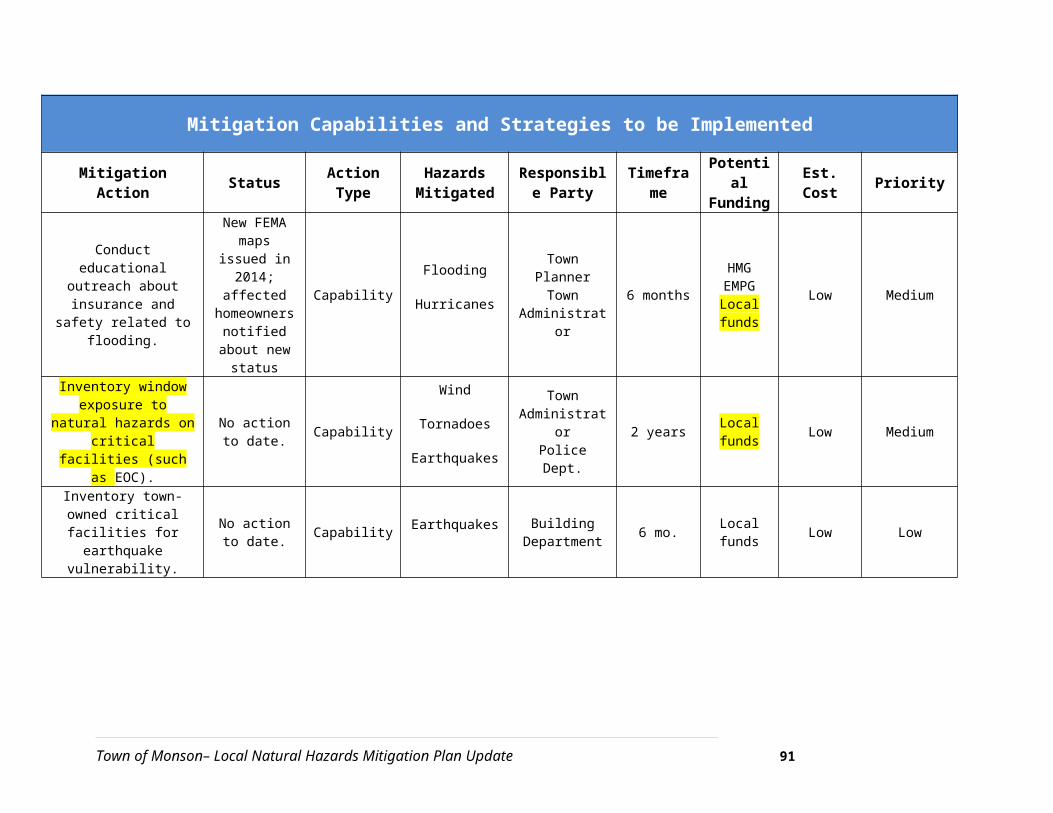
The CEM Plan for Monson includes the following generic mitigation measures for hurricane planning and response:
1. Develop and disseminate emergency public information and instructions concerning hurricane preparedness and safety.
2. Community leaders should ensure that the community is enrolled in the National Flood Insurance Program.
3. Develop and enforce local building codes to enhance structural resistance to high winds and flooding. Build new construction in areas that are not vulnerable to direct hurricane effects.
4. Make informed decisions concerning protecting natural attributes such as beaches and dunes with breakwaters and sea walls. Review National Flood Insurance Rate Maps and Hurricane Evacuation Maps for possible impact on the community. Hurricane Evacuation Maps are available for coastal communities along Buzzard’s Bay and Nantucket Sound.
5. Maintain plans for managing all hurricane emergency response activities.
The CEM Plan for Monson includes the following generic preparedness measures for hurricanes:
Ensure that warning/notification systems and equipment is ready for use at the ‘hurricane warning’ stage.
Review mutual aid agreements. Designate suitable wind and flood resistant shelters in the community and make their
locations known to the public. Prepare for coordination of evacuation from potentially impacted areas, including alternate
transportation systems and locations of special facilities
Evacuation Options
According to feedback contributed during a committee meeting on December 6, 2006 all emergency shelters in Monson (Quarry Hill Community School and the Monson Senior Center) are open to hurricane victims.
Zoning
Section 6.14.2. Wireless Communications Facilities Regulations
Section 6.14.2. [Purpose]. The purpose of this subsection of the Zoning By-Law is to establish appropriate siting criteria and standards for wireless communications facilities, to minimize the adverse impact on adjacent properties, to preserve scenic views, to limit the number and height of such facilities, to promote the shared use of existing facilities to reduce the need for new facilities, and to provide maximum wireless coverage as mandated by Section 704 of the Federal Telecommunications
Town of Monson– Local Natural Hazards Mitigation Plan Update 96

Act of 1996, while protecting the historic and residential character of the Town of Monson, the property values of the community and health and safety of citizens.
Section 6.14.2 Wireless Communications Facilities Regulations [Restrictions]
Section 6.14.2.7. All wireless communications towers shall be designed to be constructed at minimum height necessary to accommodate the anticipated and future use. In residential zoning districts, wireless communications facilities shall not exceed one hundred (100) feet in height as measured from ground level at the base of the tower.
Section 6.14.2.8. All wireless communications towers shall be pre-engineered to fail at a pre-determined height and “fold in half’ in the event of a catastrophic failure.
Section 6.14.2.9. The setback of a wireless communications tower from the lot line or street line of the lot on which it is located shall be at least equal to 150% of the tower’s height. Further, within the residential districts (RV & RR) the tower shall be located a minimum of five hundred (500) feet from existing lot lines.
Restrictions on Development
The only restrictions on development that are wind-related are the provisions in the zoning bylaw related to telecommunications facilities.
Mobile Homes
According to the Town of Monson Zoning Bylaws, mobile homes are an allowed use in the RV and RR districts. Furthermore, trailers may be replaced if they are an existing unit, are not replaced with a larger unit and are in compliance with the state building code.
State Building Code
For new or recently built structures, the primary protection against wind-related damage is construction that adheres to the State Building Code, which, when followed, results in buildings that withstand high winds. The Town of Monson has professional building inspection and code enforcement services.
Tornadoes
Town of Monson– Local Natural Hazards Mitigation Plan Update 97

Management Plans
The CEM Plan for Monson includes the following generic mitigation measures for tornado planning and response:
Develop and disseminate emergency public information and instructions concerning tornado safety, especially guidance regarding in-home protection and evacuation procedures, and locations of public shelters.
Strict adherence should be paid to building code regulations for all new construction.
Maintain plans for managing tornado response activities. Refer to the non-institutionalized, special needs and transportation resources listed in the Resource Manual.
The CEM Plan for Monson includes the following generic preparedness and response measures for tornadoes:
Designate appropriate shelter space in the community that could potentially withstand tornado impact.
Periodically test and exercise tornado response plans.
Put Emergency Management on standby at tornado ‘watch’ stage.
At tornado ‘warning’ stage, broadcast public warning/notification safety instructions and status reports.
Conduct evacuation, reception, and sheltering services to victims.
Dispatch search and rescue teams.
Dispatch emergency medical teams.
Activate mutual aid agreements.
Take measures to guard against further injury from such dangers as ruptured gas lines, downed trees and utility lines, debris, etc.
Acquire needed emergency food, water, fuel, and medical supplies.
Take measures relating to the identification and disposition of remains of the deceased.
Town of Monson– Local Natural Hazards Mitigation Plan Update 98

Evacuation Plans
There is no shelter for tornado victims identified in the Monson CEM Plan.
Wildfires/Brushfires
Management Plans
The Monson CEM Plan does not include any specific information on wildfires.
Regulatory Measures
Burn Permits: The Monson Fire Department issues burn permits in Monson in accordance with M.G.L. 148.
Subdivision Review: The Monson Fire Department reviews subdivision regulations to ensure that road widths are adequate to accommodate emergency vehicles and works with the building inspector to guarantee an adequate flow of water for the purposes of fighting a fire.
Public Education/Outreach: The Monson Fire Department partners with the Monson Senior Center to make sure batteries have been replaced and/or that smoke detectors have been installed where they are needed.
Restrictions on Development
There are currently no restrictions on development that are based on the need to mitigate the hazards of wildfires/brushfires.
Earthquakes
Management Plans
The Monson CEM Plan lists the following generic mitigation measures for earthquakes:
Community leaders in cooperation with Emergency Management Personnel should obtain local geological information and identify and assess structures and land areas that are especially vulnerable to earthquake impact and define methods to minimize the risk.
Strict adherence should be paid to land use and earthquake resistant building codes for all new construction.
Town of Monson– Local Natural Hazards Mitigation Plan Update 99

Periodic evaluation, repair, and/or improvement should be made to older public structures.
Emergency earthquake public information and instructions should be developed and disseminated.
Earthquake drills should be held in schools, businesses, special care facilities, and other public gathering places.
The Monson CEM Plan lists the following generic preparedness and response measures for earthquakes:
Earthquake response plans should be maintained and ready for immediate use.
All equipment, supplies and facilities that would be needed for management of an earthquake occurrence should be maintained for readiness.
Emergency Management personnel should receive periodic training in earthquake response.
If the designated Emergency Operations Center (EOC) is in a building that would probably not withstand earthquake impact, another building should be chosen for an earthquake EOC.
Mass Care shelters for earthquake victims should be pre-designated in structures that would be most likely to withstand earthquake impact.
EOC will be activated and response will immediately be engaged to address any and all earthquake effects listed.
Emergency warning/notification information and instructions will be broadcast to the public.
Search and rescue teams will be dispatched.
Emergency medical teams will be dispatched.
Firefighters will address fires/explosions, and HAZMAT incidents.
Law enforcement personnel will coordinate evacuation and traffic control.
Reception centers and shelters will be opened and staffed.
Town of Monson– Local Natural Hazards Mitigation Plan Update 100

Animal control measures will be taken.
Law enforcement personnel will protect critical facilities and conduct surveillance against criminal activities.
Immediate life-threatening hazards will be addressed such as broken gas lines, downed utility wires, and fire control resources.
Emergency food, water, and fuel will be acquired. Activate mutual aid.
Measures will be taken relating to identification and disposition of remains of deceased by the Chief Medical Examiner.
Evacuation Options
The Monson CEM lists several shelters available to earthquake victims: Quarry Hill Street, Monson Fire Station, Monson Senior Center, Granite Valley Middle School, Monson Developmental Center, Palmer Senior High School, Monson Sr. High School, Monson Fire Station.
The maximum peak population affected by an earthquake is estimated at 1,900 people.
State Building Code
State and local building inspectors are guided by regulations put forth in the Massachusetts State Building Code. The first edition of the Massachusetts State Building Code went into effect on January 1, 1975 and included specific earthquake resistant design standards. These seismic requirements for new construction have been revised and updated over the years and are part of the current, 6th Edition of the Massachusetts State Building Code. Given that most structures in Massachusetts were built before 1975, of many buildings and structures do not have specific earthquake resistant design features. According to the 2000 U.S. Census, 92 percent of the housing in Monson was built before 1970. In addition, built areas underlain by artificial fill, sandy or clay soils are particularly vulnerable to damage during an earthquake.
Restrictions on Development
There are no seismic-related restrictions on development.
Dam Failures
The only mitigation measures in place are the state regulations that control the construction and inspection of dams.
Town of Monson– Local Natural Hazards Mitigation Plan Update 101

The Monson CEM Plan states that there are three categories of dam failure or overspill and that action should be taken according to hazard rating:
Type 1: Slowly developing condition
Activate EOC
Activate all communication networkso Establish communications with Command Posto On a 24-hour basis.
Release public information
Notifyo MEMA Region Headquarterso American Red Crosso Downstream communities
Review Plans for evacuation and shelteringo Evacuation
Routes Notification
o Sheltering Availability and capacity Food, supplies and equipment Shelter owners and managers Other communities (if out of town sheltering is required)
Require “Stand By” status of designated emergency response forces.
Type 2: Rapidly developing condition
Establish a 24-hour communications from dam site to EOC.
Assemble, brief and assign specific responsibilities to emergency response forces.
Release public information.
Obtain and prepare required vehicles/equipment for movement.
Prepare to issue warning.Type 3: Practically instantaneous failure
Town of Monson– Local Natural Hazards Mitigation Plan Update 102

Issue warning
Commence immediate evacuation.
Commit required resources to support evacuation.
Activate shelters or coordinate activation of shelters located outside the community.
Notify:
o MEMA Region Headquarters
o Red Cross
Initiate other measures as required to protect lives and property.
Management Plans and Regulatory Measures
The Monson CEM Plan contains the following generic mitigation measures for dam failure:
Develop and conduct public education programs concerning dam hazards.
Maintain up-to-date plans to deal with threat and actual occurrence of dam over-spill or failure.
Emergency Management and other local government agencies should familiarize themselves with technical data and other information pertinent to the dams, which impact Monson. This should include determining the probable extent and seriousness of the effect to downstream areas.
Dams should be inspected periodically and monitored regularly.
Repairs should be attended to promptly.
As much as is possible burdens on faulty dams should be lessened through stream re-channeling.
Identify dam owners.
Determine minimum notification time for down stream areas.
The Monson CEM Plan contains the following generic preparedness and response measures for dam failure:
Town of Monson– Local Natural Hazards Mitigation Plan Update 103
Pre-place adequate warning/notification systems in areas potentially vulnerable to dam failure impact.
Pre-place procedures for monitoring dam site conditions at first sign of any irregularity that could precipitate dam failure.
Identify special needs populations, evacuations routes, and shelters for dam failure response.
Have sandbags, sand, and other items to reinforce dam structure or flood proof flood prone areas.
Disseminate warning/notification of imminent or occurring dam failure.
Coordinate evacuation and sheltering of affected populations.
Dispatch search and rescue teams.
Coordinate evacuation and sheltering of affected populations.
Activate mutual aid if needed.
Acquire additional needed supplies not already in place, such as earth moving machinery.
Establish incident command post as close to affected area as safely possible.
Provide security for evacuated public and private property.
Evacuation Options
The Monson CEM Plan identifies Conant Brook as the highest risk to the Town.
Permits Required for New Dam Construction
Massachusetts State Law (M.G.L. Chapter 253 Section 45) regulates the construction of new dams. A permit must be obtained from the Department of Conservation and Recreation (DCR) before construction can begin. One of the permit requirements is that all local approvals or permits must be obtained.
Town of Monson– Local Natural Hazards Mitigation Plan Update 104

Dam Inspections
The DCR requires that dams rated as Low Hazards are inspected every ten (10) years and dams that are rated as Medium/Significant Hazards are inspected every five (5) years.
Zoning
There is no mention made regarding the construction of new dams in the Town of Monson zoning or subdivision regulations.
Restrictions on Development
There are no town restrictions on dam locations. The DCR issues permits for new dams and does have the authority to deny a permit if it is determined that the design and/or location of the dam is not acceptable.
Town of Monson– Local Natural Hazards Mitigation Plan Update 105