introduction - rudgate village · pdf fileintroduction thorp arch estate thorp arch boston spa...
TRANSCRIPT
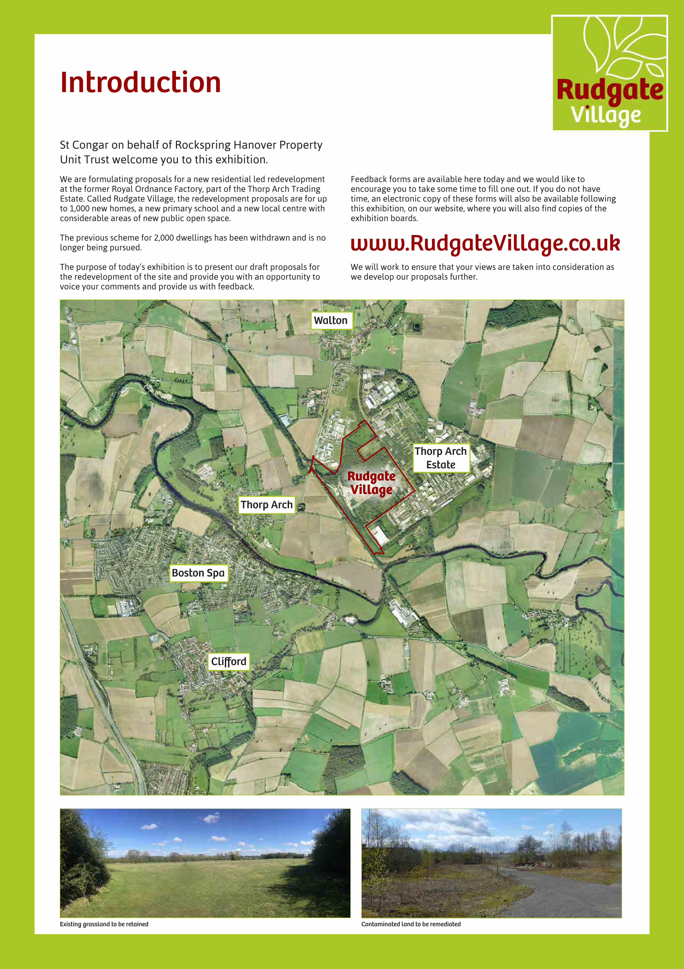
Introduction
Thorp Arch Estate
Thorp Arch
Boston Spa
Clifford
Walton
RudgateVillage
St Congar on behalf of Rockspring Hanover Property Unit Trust welcome you to this exhibition.
Feedback forms are available here today and we would like to encourage you to take some time to fill one out. If you do not have time, an electronic copy of these forms will also be available following this exhibition, on our website, where you will also find copies of the exhibition boards.
We will work to ensure that your views are taken into consideration as we develop our proposals further.
Existing grassland to be retained Contaminated land to be remediated
www.RudgateVillage.co.uk
We are formulating proposals for a new residential led redevelopment at the former Royal Ordnance Factory, part of the Thorp Arch Trading Estate. Called Rudgate Village, the redevelopment proposals are for up to 1,000 new homes, a new primary school and a new local centre with considerable areas of new public open space.
The previous scheme for 2,000 dwellings has been withdrawn and is no longer being pursued.
The purpose of today’s exhibition is to present our draft proposals for the redevelopment of the site and provide you with an opportunity to voice your comments and provide us with feedback.

Site History
From its rural past the site has been subject to some major changes over the past 165 years which have fundamentally changed the landscape and character of the site.
New rail line introduced serving Church Fenton, Wetherby, Thorp Arch, Tadcaster and Spofforth.
1847
Site chosen by the Ministry of Defence for the establishment of Royal Ordnance Factory No.8.
1940’s
Site was completed, covering 590 acres and costing £5.9 million. The comprehensive development of the site included: - Over 600 new buildings - 25 miles of internal railway line - 9 miles of roads - 2 reservoirsEmploying over 10,000 people in World War 2 the ROF produced a range of small to medium ammunitions.
1942
End of World War 2 the site stopped producing ammunitions and was instead used to store surplus war material.
1945
A remand centre of some 200 young offenders was built on the North part of the site (former ROF administrations site).
1950
The ROF facilities were used for the manufacture of munitions for the Korean War.
1950 - 1953
Thorp Arch ROF Closed by M.O.D.1958
Rail line between Church Fenton and Spofforth closed.
Estate bought by George Moore who developed the site as a trading estate building the George Moore furniture factory - which is still a major employer on the estate.
Early 1960’s
The British Library has occupied the north east corner of the former ROF site since 1961 and has continually developed and enhanced the building since this time.
1961
Since the development of what has been claimed as the UK’s first retail park in the early 1960’s, Thorp Arch Trading Estate has continued to develop and grow. The trading estate now forms the eastern and southern sections of the site with a wide range of retailers, industrial and commercial occupiers on site and providing circa. 2,000 jobs. The estate is now owned and run by the Rockspring Hanover Property Unit Trust.
1960’s - present
New rail line introduced serving Church Fenton, Wetherby, Thorp Arch, Tadcaster and Spofforth.
SITE HISTORYFrom its rural past the site has been subject to some major changes over the past 165 years which have fundamentally changes the landscape and character of the site.
1847
Site chosen by the Ministry of Defence for the establishment of Royal Ordnance Factory No.8
1940’s
Site was completed, covering 590 acres and costing £5.9 million. The comprehensive development of the site included: - Over 600 new buildings - 25 miles of internal railway line - 9 miles of roads - 2 reservoirsEmploying over 10,000 people in World War 2 the ROF produced a range of small to medium ammunitions.
1942
End of World War 2 the site stopped producing ammunitions and was instead used to store surplus war material.
1945
A remand centre of some 200 young offenders was built on the North part of the site (former ROF administrations site).
1950
The ROF facilities were used for the manufacture of munitions for the Korean War.
1950 - 1953
Thorp Arch ROF Closed by M.O.D.1958
Rail line between Church Fenton and Spofforth closed
Estate bought by George Moore who developed the site as a trading estate building the George Moore furniture factory - which is still a major employer on the estate.
Early 1960’s
The British Library has occupied the north east corner of the former ROF site since 1961 and have continually developed and enhanced the building since this time.
1961
Since the development of what has been claimed as the UK’s first retail park in the early 1960’s, Thorp Arch Trading Estate has continued to develop and grow. The trading estate now forms the eastern and southern sections of the site with a wide range of retailers, industrial and commercial occupiers on site and providing circa. 2,000 jobs. The estate is now owned and run by the Rockspring Hanover Property Unit Trust and has aspirations to grow and develop further.
1960’s - present

Constraints and Opportunties
We recognise that the site has had an interesting past and if you look carefully, it still contains some curious features. In our proposals, we try to respond and indeed celebrate the physical oddities that made ordnance factories distinctive. We have also studied the local ecology and the habitats and we will create some very important long-term strategies to enhance and protect the best of what we’ve found. However, we also understand that the site’s legacy as a war-time munitions factory has left problems that need to be addressed as a priority. There will be site-wide ground contamination investigation to finalise a comprehensive remediation strategy. This will include a ‘confidence scrape’ in all development areas (houses and gardens), although we will wherever possible preserve mature trees and high value ecological habitats over the wider landscaped areas.
In ecological terms, we will preserve the high quality habitats and we will protect delicate protected species. By careful design, we will recreate high quality habitats, such as calcareous grasslands,
where they have been allowed to become over-run. As part of our proposals, we will put in place a whole series of long-term management protocols to ensure that the ecologically important areas we create will flourish long into the future.
As has been encouraged by successive governments for a generation, our intention over the next few years is to make positive use of this important brown-field site in order to address the pressing national and local need for new housing. We aim to build a balanced community with facilities that respond to people’s needs. We will provide modern sustainable housing in a variety of sizes and tenures – housing that is distinctive and has real character. There will be plenty of space for outdoor leisure and play as well as links into the established cycle network. We are trying to lay the foundations for a harmonious local settlement, a place that will grow and mature over the coming years by responding to, reflecting and indeed adopting the character of the locality.
Reinforce landscape screen to
HM prison
Managed Wildlife Meadow
Groups of trees to be preserved
Proposed alignment of new link
road, to avoid principal trees
Central green space includes
hedges, trees and water course
Power lines
Existing access
Existing grassland area
Proposed access on centre line of existing building and to extend the ‘grid’
Create a new focus at entry point to site, including school and local facilities
Attractive tree-lined street
Indicates existing structure
New development to reflect ‘angled’ setting out of these buildings
Play area to be relocated
Area of calcareous grassland to be
retained and enhanced
Potential access
Potential extension of the existing road network grid
Proposed ecological links across the site
Identified trees to be retained wherever possible
Area of hedge/ tree planting to be retained and improved
Existing watercourse re-aligned & improved
Existing drainage
Existing private drainage
Area subject to significant remediation
Existing cycle route
Proposed link to existing cycle route
Buffer to existing employment area
Extend and reinforce existing tree planting
Connections to open/green spaces
Existing watercourse and park area, could be extended
Proposed landscaped corridor link
Potential busgate option
Sustrans Cycle route 665
Existing Watercourse Existing Retail Park
Former “Burning Ground” to be remediated
Existing unmanaged woodland
Clustered Bellflower
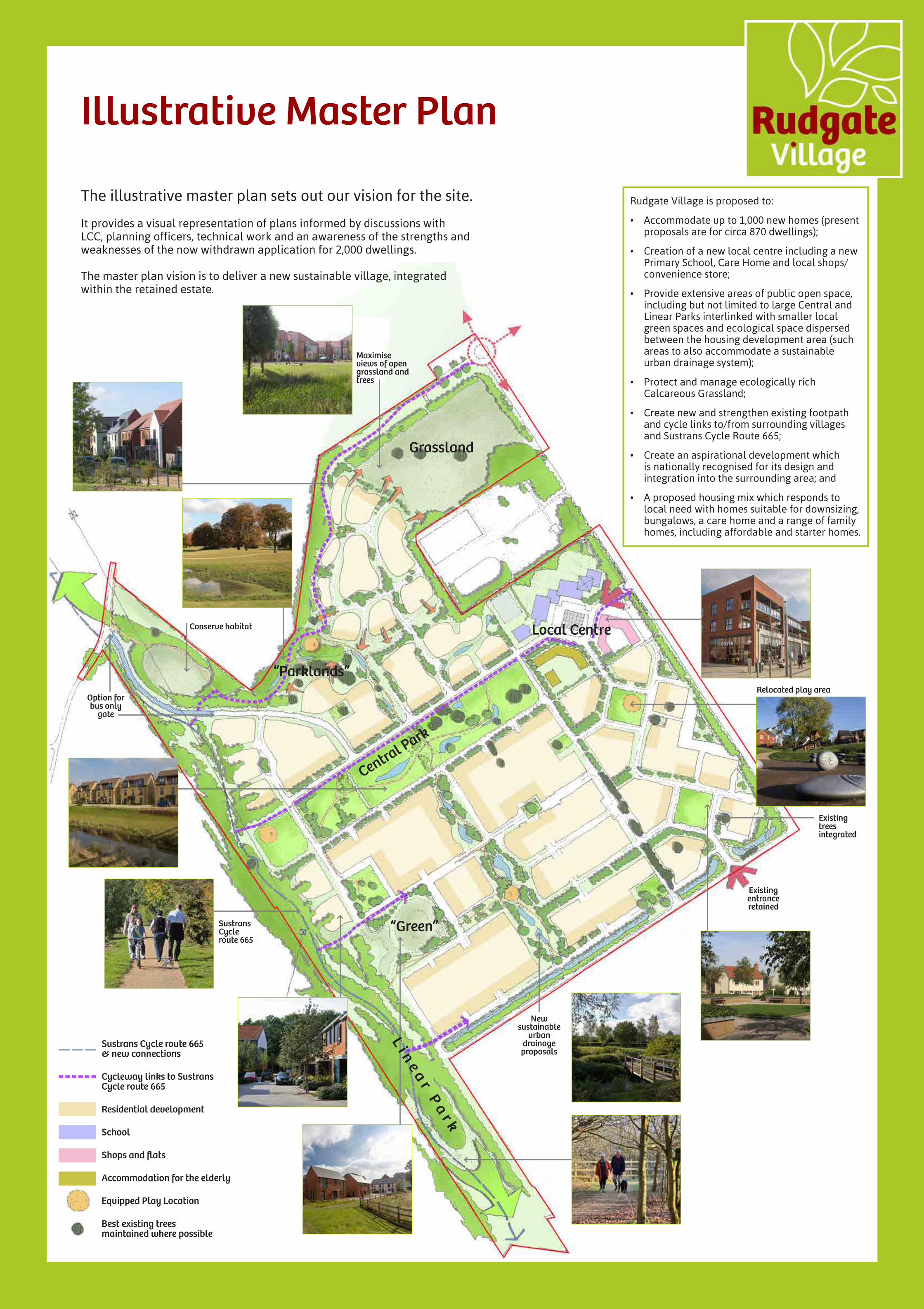
Illustrative Master Plan
The illustrative master plan sets out our vision for the site.
It provides a visual representation of plans informed by discussions with LCC, planning officers, technical work and an awareness of the strengths and weaknesses of the now withdrawn application for 2,000 dwellings.
The master plan vision is to deliver a new sustainable village, integrated within the retained estate.
Central Park
“Green”
Local Centre
Grassland
“Parklands”
Rudgate Village is proposed to:
• Accommodate up to 1,000 new homes (present proposals are for circa 870 dwellings);
• Creation of a new local centre including a new Primary School, Care Home and local shops/convenience store;
• Provide extensive areas of public open space, including but not limited to large Central and Linear Parks interlinked with smaller local green spaces and ecological space dispersed between the housing development area (such areas to also accommodate a sustainable urban drainage system);
• Protect and manage ecologically rich Calcareous Grassland;
• Create new and strengthen existing footpath and cycle links to/from surrounding villages and Sustrans Cycle Route 665;
• Create an aspirational development which is nationally recognised for its design and integration into the surrounding area; and
• A proposed housing mix which responds to local need with homes suitable for downsizing, bungalows, a care home and a range of family homes, including affordable and starter homes.
New sustainable
urban drainage proposals
Relocated play area
Maximise views of open grassland and trees
Sustrans Cycle route 665
Existing trees integrated
Existing entrance retained
Conserve habitat
Li n
e ar P
ar k
Option for bus only
gate
Sustrans Cycle route 665 & new connections
Cycleway links to Sustrans Cycle route 665
Residential development
School
Shops and flats
Accommodation for the elderly
Equipped Play Location
Best existing trees maintained where possible
Transport
General
• Updated traffic surveys have been carried out;
• Committed developments in the local area have been accounted for along with future employment development growth on the Thorp Arch Estate;
• There is sufficient capacity on the local highway network to accommodate significant development on the site;
• The alternative to residential development would be more employment with the potential for increased HGV traffic.
Accessibility
• Extensive pedestrian and cycle network available within the locality including good off-road links;
• Good employment, leisure, and school facilities within walking and cycling distance;
• New pedestrian and cycling facilities within the development will link to the existing provision;
• Rudgate village centre with local facilities to reduce the need to travel;
• Existing bus services pass close to the site;
• Enhanced bus provision, including the diversion of existing services into the site, will improve service provision for existing and future residents.
Access
• The proposed development will be accessed from the existing highway network;
• New Junctions onto Street 5, and Church Causeway are proposed;
• The new local centre will provide a new primary school; a convenience store, and local shops. The location of these facilities will encourage both new residents and existing people employed on the wider trading estate to walk and cycle to the new local centre.
Traffic Impact
• Separate distribution patterns for Trip Types:• Journeys to Work;• Journeys to School; and• Journeys for all other purposes.
• Traffic Growth has been applied;
• Generated traffic flows derived from local surveys;
• Three out of five local junctions analysed show no significant impact;
• Two out of five junctions show no Severe impact, but mitigation is considered to help alleviate local concerns (see above plan).
Junction 1. Wighill Lane/Street 5, priority junction
Junction 2. Wighill Lane/Street C East, roundabout
Junction 3. Wetherby Road/Walton Rd/Wighill Lane, priority junction
Junction 4. Walton Road/Privas Way, four arm roundabout
Junction 5. High Street/Bridge Road, priority junction
Site Access
Site Access
5
4
3
2
1
4
3 1
2
5

Proposed Highway Works
Proposed Highway Works
• New priority junction works street 5 (see plan);
• New junction works at Church Causeway:• Option 1 - no bus gate (see plan); OR• Option 2 - bus gate (see plan);
• Enhanced bus service to include diversion into site;
• New bus shelters with real time information;
• Improved pedestrian and cycle links throughout the site;
• Improvements to Street 5/Wighill Lane Junction to include signalisation (see plan);
• New PUFFIN Crossing on Wighill Lane (see plan);
• Traffic calming in Walton;
• Works in Boston Spa:• Option 1 - Possible signalisation of Bridge Road/High Street
and Thorp Arch Bridge (see plan); OR• Option 2 - Traffic Calming within Boston Spa.
Proposed new signal control junction at Street 5/Wighill Lane
Church Causeway: Option 1 - Change priority and no bus gate Bridge Road / High Street, Boston Spa
Church Causeway: Option 2 - bus gate
PUFFIN Crossing on Wighill Lane
We set out below a list of measures that we believe will encourage modal shift away from the car and also mitigate the impact of the additional traffic on the surrounding road system.
Please note that we have identified two options for how we could treat the western site access from Church Causeway, and also two options to respond to a modest increase in traffic through Boston Spa. The response form provides the opportunity to select your preferred options and we would be grateful to receive your views on this.
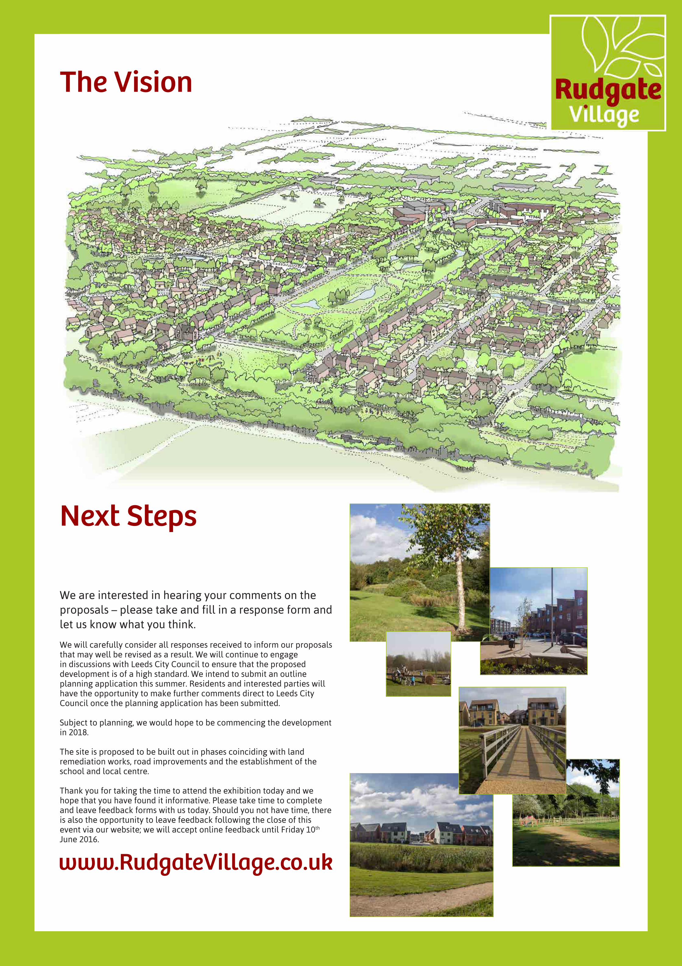
We are interested in hearing your comments on the proposals – please take and fill in a response form and let us know what you think.
We will carefully consider all responses received to inform our proposals that may well be revised as a result. We will continue to engage in discussions with Leeds City Council to ensure that the proposed development is of a high standard. We intend to submit an outline planning application this summer. Residents and interested parties will have the opportunity to make further comments direct to Leeds City Council once the planning application has been submitted.
Subject to planning, we would hope to be commencing the development in 2018.
The site is proposed to be built out in phases coinciding with land remediation works, road improvements and the establishment of the school and local centre.
Thank you for taking the time to attend the exhibition today and we hope that you have found it informative. Please take time to complete and leave feedback forms with us today. Should you not have time, there is also the opportunity to leave feedback following the close of this event via our website; we will accept online feedback until Friday 10th June 2016.
www.RudgateVillage.co.uk
Next Steps
The Vision