introduction to drone technology - local institutes portal · introduction to drone technology ......
TRANSCRIPT

16/03/2017 116/03/2017 116/03/2017 116/03/2017 116/03/2017 1LAUNCH SURVEY ANALYSE• •
Introduction to Drone Technology
Matthew Greaves

16/03/2017 216/03/2017 216/03/2017 216/03/2017 216/03/2017 2LAUNCH SURVEY ANALYSE• •
Originally born from an idea that surfaced whilst on a Mountain Rescue callout,Drones on Demand was founded in January 2017, but has been four years in themaking.
I’ve been flying drones as a hobby since 2013, testing the technology and getting muchneeded flying experience.
I started the journey to becoming a Commercial Drone Operator by completingGround School in late 2014 , the standard flight tests in early 2015 and advanced flighttests in late 2015. The CAA granted our first permission in early 2016 which is nowrenewed annually.
I’m a successful IT Programme Manager and have worked for FTSE companies over thelast fifteen years. Having tried to fly drones part-time, I’ve made the decision to‘retire’ from Corporate IT to focus on drones full time.
I’m also a volunteer member of Calder Valley Search and Rescue Team.
Introducing Drones on Demand

16/03/2017 316/03/2017 316/03/2017 316/03/2017 316/03/2017 3LAUNCH SURVEY ANALYSE• •
Drones and the law• The UK’s Civil Aviation Authority (CAA) is leading the world’s response to trying to ensure that drone flight is safe
and appropriately regulated
• Specific aviation regulation in the UK is clear and well established:
• CAP393 – The Air Navigation Order
• Articles 94, 95 and 241
• CAP722 – Unmanned Aircraft System Operations in UK Airspace – Guidance
• Permit required from CAA for commercial operation
• Maximum sentence for breaking these laws is 5 years imprisonment or unlimited fine
• Privacy and Data Protection laws must also be taken into consideration

16/03/2017 416/03/2017 416/03/2017 416/03/2017 416/03/2017 4LAUNCH SURVEY ANALYSE• •
The Drone Code

16/03/2017 516/03/2017 516/03/2017 516/03/2017 516/03/2017 5LAUNCH SURVEY ANALYSE• •
The Drone Code
16/03/2017 616/03/2017 616/03/2017 616/03/2017 616/03/2017 6LAUNCH SURVEY ANALYSE• •
Drone use in the Insurance Sector

16/03/2017 716/03/2017 716/03/2017 716/03/2017 716/03/2017 7LAUNCH SURVEY ANALYSE• •
Phoenix House & Neptune DC• Planning permission granted for construction of
office block and distribution centre
Canal
River
Railway
Cricket Club

16/03/2017 816/03/2017 816/03/2017 816/03/2017 816/03/2017 8LAUNCH SURVEY ANALYSE• •
Prior to Construction• Flood risk assessment is
undertaken with a detailed elevation map of the site
• A detailed site plan is created to use as a base comparator during construction

16/03/2017 916/03/2017 916/03/2017 916/03/2017 916/03/2017 9LAUNCH SURVEY ANALYSE• •
During Construction• Regular progress monitoring
• Evidence that certain processes have been followed
• Evidence that steps were completed by a particular date
• Early identification of errors
• Erosion monitoring and rectification
• Verification of height of earthworks / flood defences

16/03/2017 1016/03/2017 1016/03/2017 1016/03/2017 1016/03/2017 10LAUNCH SURVEY ANALYSE• •
Construction Complete / Tenant moves in• Verification of condition at
handover
• Regular monitoring of condition especially roof
• Regular monitoring of flood defences and their condition
• Annual inspection of condition of solar panels or wind turbine
• Regular data collection can be used to identify wear and tear

16/03/2017 1116/03/2017 1116/03/2017 1116/03/2017 1116/03/2017 11LAUNCH SURVEY ANALYSE• •
Claim: High Winds Damage Neptune!• Quickly assess extent of damage
• Quantify area damaged• Quantify amount of material to be
removed from site
• Easy access – no need for vehicle access to site
• Low risk – no need to commit human assets for initial assessment
• Can be live streamed to multiple locations
• Comparison can be made with last inspection to identify new damage
• Verification of completion and standard of repair

16/03/2017 1216/03/2017 1216/03/2017 1216/03/2017 1216/03/2017 12LAUNCH SURVEY ANALYSE• •
Claim: Fire Damages Phoenix!• Additionally wider survey
can be undertaken to potentially identify any external factors
• Potential to assist with apportioning liability
• Quantification of amount of material to be removed
Wind Direction
Direction Fire Damage
Bonfire

16/03/2017 1316/03/2017 1316/03/2017 1316/03/2017 1316/03/2017 13LAUNCH SURVEY ANALYSE• •
Disaster: Worst Flooding in Living Memory!• Rapid assessment of extent
of damage
• Wide area survey or targeted survey of your risks
• Proactively initiate / manage claims
• Quickly mobilise the right resources to the right place
• Data can be shared between insurers
16/03/2017 1416/03/2017 1416/03/2017 1416/03/2017 1416/03/2017 14LAUNCH SURVEY ANALYSE• •
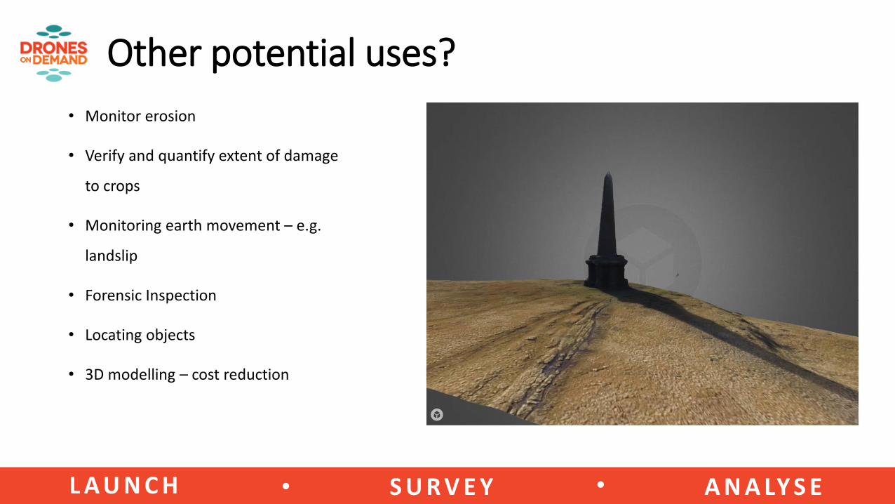
Other potential uses?
• Monitor erosion
• Verify and quantify extent of damage
to crops
• Monitoring earth movement – e.g.
landslip
• Forensic Inspection
• Locating objects
• 3D modelling – cost reduction

16/03/2017 1516/03/2017 1516/03/2017 1516/03/2017 1516/03/2017 15LAUNCH SURVEY ANALYSE• •
Questions?