introduction to global navigation satellite system (gnss ...dinesh/gnss_train_files/202001... ·...
TRANSCRIPT

Slide : 1Training on GNSS – Course (T151-40), Organized by: GIC/AIT, CSIS/UT and ICG, held at: GIC/AIT, Thailand from 6 – 10 JAN 2020
Dinesh Manandhar, CSIS, The University of Tokyo, [email protected]
Introduction to Global Navigation Satellite System (GNSS)
Module: 1Dinesh Manandhar
Center for Spatial Information Science
The University of Tokyo
Contact Information: [email protected]
Slide : 2Training on GNSS – Course (T151-40), Organized by: GIC/AIT, CSIS/UT and ICG, held at: GIC/AIT, Thailand from 6 – 10 JAN 2020
Dinesh Manandhar, CSIS, The University of Tokyo, [email protected]
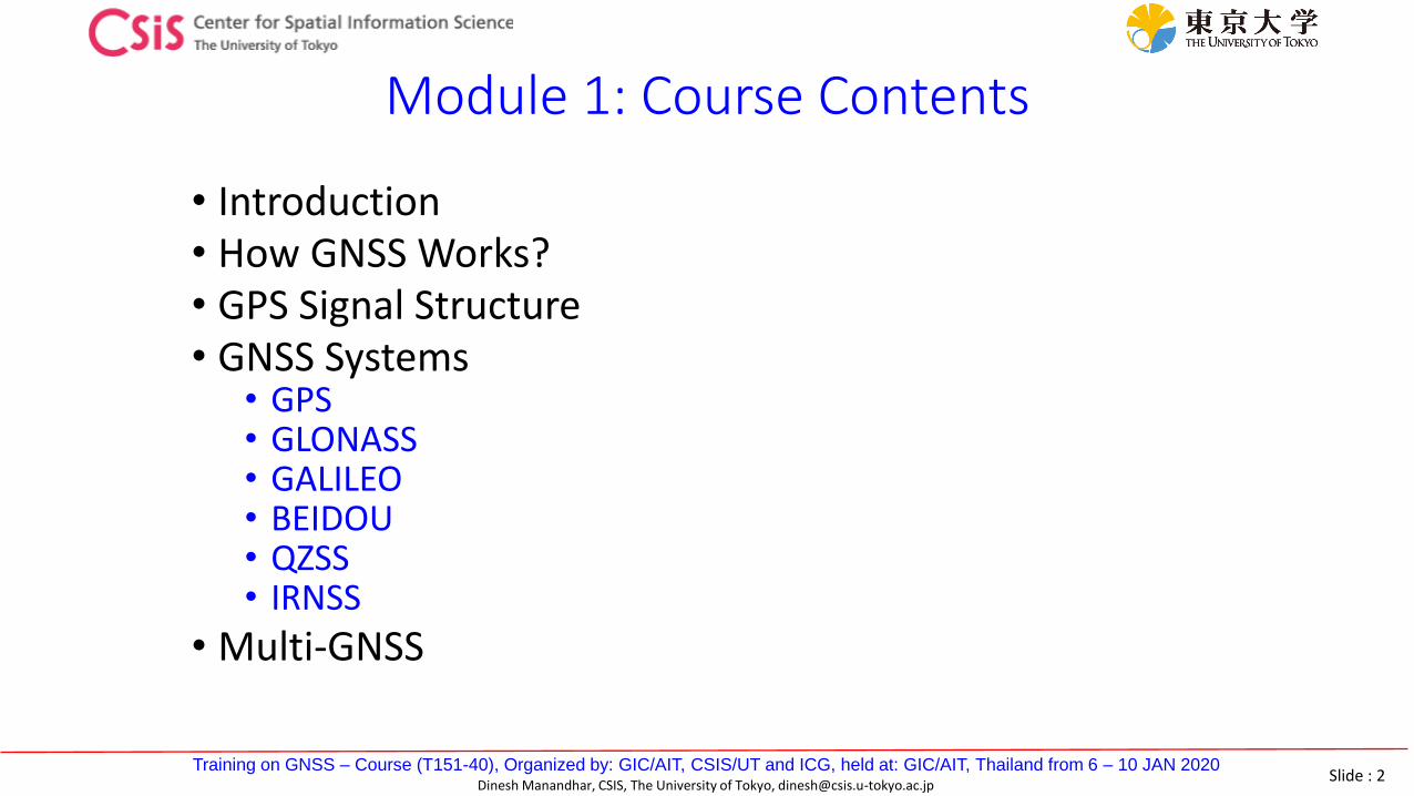
Module 1: Course Contents
• Introduction• How GNSS Works? • GPS Signal Structure• GNSS Systems
• GPS• GLONASS• GALILEO• BEIDOU• QZSS• IRNSS
• Multi-GNSS

Slide : 3Training on GNSS – Course (T151-40), Organized by: GIC/AIT, CSIS/UT and ICG, held at: GIC/AIT, Thailand from 6 – 10 JAN 2020
Dinesh Manandhar, CSIS, The University of Tokyo, [email protected]
Fundamental Problem
• How to know my location precisely ?• In any condition
• At any time
• Everywhere on earth (at least outdoors!)
• How to navigate to the destination?• Guidance or Navigation
• How to synchronize time globally? • Mobile phones
• Financial Institutes
Where am I
on the Earth?350 40’ 41”
1390 39’ 40”
How far ?
Which Route ?

Slide : 4Training on GNSS – Course (T151-40), Organized by: GIC/AIT, CSIS/UT and ICG, held at: GIC/AIT, Thailand from 6 – 10 JAN 2020
Dinesh Manandhar, CSIS, The University of Tokyo, [email protected]
Navigation Types
• Landmark-based Navigation• Stones, Trees, Monuments
• Limited Local use
• Celestial-based Navigation• Stars, Moon
• Complicated, Works only at Clear Night
• Sensors-based Navigation• Dead Reckoning
• Gyroscope, Accelerometer, Compass, Odometer
• Complicated, Errors accumulate quickly
• Radio-based Navigation• LORAN, OMEGA
• Subject to Radio Interference, Jamming, Limited Coverage
• Satellite-based Navigation or GNSS• TRANSIT, GPS, GLONASS, GALILEO, QZSS,
BEIDOU (COMPASS), IRNSS• Global, Difficult to Interfere or Jam, High
Accuracy & Reliability

Slide : 5Training on GNSS – Course (T151-40), Organized by: GIC/AIT, CSIS/UT and ICG, held at: GIC/AIT, Thailand from 6 – 10 JAN 2020
Dinesh Manandhar, CSIS, The University of Tokyo, [email protected]
What is GNSS?
• Global Constellation• GPS USA
• GLONASS, Russia
• Galileo, Europe
• BeiDou (COMPASS) / BDS, China
Global Navigation Satellite System (GNSS) is the standard generic term for all navigation satellites systems like GPS, GLONASS, GALILEO, BeiDou, QZSS, NAVIC.
• Regional Constellation• QZSS, Japan
• NAVIC (IRNSS), India

Slide : 6Training on GNSS – Course (T151-40), Organized by: GIC/AIT, CSIS/UT and ICG, held at: GIC/AIT, Thailand from 6 – 10 JAN 2020
Dinesh Manandhar, CSIS, The University of Tokyo, [email protected]
Satellite Based Augmentation System (SBAS)
• Satellite Based Augmentation System (SBAS) are used to augment GNSS Data• Provide Higher Accuracy and Integrity• Some correction data like satellite orbit, satellite clock and atmospheric data are
broadcasted from communication satellites• Used by ICAO for Aviation
• SBAS Service Providers • WAAS, USA• MSAS, Japan• EGNOS, Europe• GAGAN, India• SDCM, Russia• Nigeria• Korea (Also navigation system)• Australia

Slide : 7Training on GNSS – Course (T151-40), Organized by: GIC/AIT, CSIS/UT and ICG, held at: GIC/AIT, Thailand from 6 – 10 JAN 2020
Dinesh Manandhar, CSIS, The University of Tokyo, [email protected]
Determine the Distance using Radio Wave0ms
25ms
50ms0ms
25ms
50ms
75ms
Satellite Transmits Signal at 0ms.Receiver Receives the Same Signal after 67ms.
Distance = (Transmission time – Reception time) × Speed of light
Speed of Light300,000 km/s
Satellite with a known position transmit a regular time signal.

Slide : 8Training on GNSS – Course (T151-40), Organized by: GIC/AIT, CSIS/UT and ICG, held at: GIC/AIT, Thailand from 6 – 10 JAN 2020
Dinesh Manandhar, CSIS, The University of Tokyo, [email protected]
Principle of Satellite-based Navigation
Correlation between Incoming Signal and
Receiver Generated Signal
bzzyyxx kkkk 222
If k ≥ 4, solve for x, y, z and clock bias, b
(x,y,z)
(xk,yk,zk)
∆t

Slide : 9Training on GNSS – Course (T151-40), Organized by: GIC/AIT, CSIS/UT and ICG, held at: GIC/AIT, Thailand from 6 – 10 JAN 2020
Dinesh Manandhar, CSIS, The University of Tokyo, [email protected]
GNSS Requirements
• GNSS needs a common time system.• Each GNSS satellite has atomic clocks.• How about user receivers?
• The signal transmission time has to be measurable.• Each GNSS satellite transmits a unique digital signature, which consists an
apparent random sequence, PRN Code• A Time Reference is transmitted using the Navigation Message
• Each signal source has to be distinguishable.• GNSS utilizes code division multiple access (CDMA) or frequency division
multiple access (FDMA).
• The position of each signal source must be known.• Each satellite sends its orbit data using the Navigation Message• Orbit Data: Almanac and Ephemeris

Slide : 10Training on GNSS – Course (T151-40), Organized by: GIC/AIT, CSIS/UT and ICG, held at: GIC/AIT, Thailand from 6 – 10 JAN 2020
Dinesh Manandhar, CSIS, The University of Tokyo, [email protected]
Characteristics of GNSS Signals
• GNSS Signals have basically three types of signals• Carrier Signal• PRN Code (C/A Code)• Navigation Data
• All GNSS Signals except GLONASS are based on CDMA• Only GLONASS use FDMA• Future Signals of GLONASS will also use CDMA
• The modulation scheme of GNSS signals• BPSK• Various versions of BOC
CDMA: Code Division Multiple AccessFDMA: Frequency Division Multiple AccessBPSK : Binary Phase Shift KeyingBOC: Binary Offset Carrier

Slide : 11Training on GNSS – Course (T151-40), Organized by: GIC/AIT, CSIS/UT and ICG, held at: GIC/AIT, Thailand from 6 – 10 JAN 2020
Dinesh Manandhar, CSIS, The University of Tokyo, [email protected]
GPS L1C/A Signal Structure
900 Phase Reverse
∑
L1 Carrier, 1575.42Mhz
C / A Code, 1.023Mhz
Navigation Data, 50Hz
L1 Band GPS Signal
X1, Clock
10.23Mhz
x154
x1/10
x1/204600
Carrier Signal
PRN Code
Navigation Data

Slide : 12Training on GNSS – Course (T151-40), Organized by: GIC/AIT, CSIS/UT and ICG, held at: GIC/AIT, Thailand from 6 – 10 JAN 2020
Dinesh Manandhar, CSIS, The University of Tokyo, [email protected]
GPS L1C/A Signal Structure
• Carrier Signal• It defines the frequency of the signal• For example:
• GPS L1 is 1575.42MHz, L2 is 1227.60MHz and L5 is 1176.45MHz
• PRN Code• Used to identify satellite ID in CDMA• Requires to modulate the data• Should have good auto-correlation and cross-correlation properties
• Navigation Data• Includes satellite orbit related data (ephemeris data)• Includes satellite clock related information (clock errors etc)

Slide : 13Training on GNSS – Course (T151-40), Organized by: GIC/AIT, CSIS/UT and ICG, held at: GIC/AIT, Thailand from 6 – 10 JAN 2020
Dinesh Manandhar, CSIS, The University of Tokyo, [email protected]
1 2 3 4 5 6 7 8 9 10
1 2 3 4 5 6 7 8 9 10
Output
G1 Polynomial: [3,10]
G2 Polynomial: [2,3,6,8,9,10]
GPS L1C/A PRN Code Generator

Slide : 14Training on GNSS – Course (T151-40), Organized by: GIC/AIT, CSIS/UT and ICG, held at: GIC/AIT, Thailand from 6 – 10 JAN 2020
Dinesh Manandhar, CSIS, The University of Tokyo, [email protected]
Characteristics of PRN Code
Cross-correlation: Only three values:1, 63 or 65 (Ideal Case)
• Maximum Cross-correlation Value is -23dB. • If any signal above this power enters a GPS receiver, it
will totally block all GPS signals. • If longer PRN code is used, receiver becomes more
resistive to Jamming signal• But, signal processing is more complex
Auto-correlation: Only four values: 1023, 1, 63 or 65 (Ideal case)
• PRN codes are very uniquely designed. • GPS and other GNSS use CDMA
• One PRN code is assigned to one satellite. • In case of GPS, PRN code is 1023 bits long.• GLONASS is different. It uses FDMA. The same code for all
satellites but different frequencies. • Some new signals of GLONASS also uses CDMA signals

Slide : 15Training on GNSS – Course (T151-40), Organized by: GIC/AIT, CSIS/UT and ICG, held at: GIC/AIT, Thailand from 6 – 10 JAN 2020
Dinesh Manandhar, CSIS, The University of Tokyo, [email protected]
PRN (Pseudo Random Noise) Code
• PRN Code is a sequence of randomly distributed zeros and ones that is one millisecond long.
• This random distribution follows a specific code generation pattern called Gold Code.
• There are 1023 zeros or ones in one millisecond.
• Each GPS satellite transmits a unique PRN Code.• GPS receiver identifies satellites by its unique PRN code or ID.
• It is continually repeated every millisecond and serves for signal transit time measurement.• The receiver can measure where the PRN code terminated or repeated.
1ms / 1023
1ms
01 1 1 10 0 0 1 0 00

Slide : 16Training on GNSS – Course (T151-40), Organized by: GIC/AIT, CSIS/UT and ICG, held at: GIC/AIT, Thailand from 6 – 10 JAN 2020
Dinesh Manandhar, CSIS, The University of Tokyo, [email protected]
Modulation
Modulation is the process of conveying a message signal, for example a digital bit stream, into a radio frequency signal that can be physically transmitted.
You want to transmit this binary code
1 1 100 0 1 1
Amplitude Shift Keying
Frequency Shift Keying

Slide : 17Training on GNSS – Course (T151-40), Organized by: GIC/AIT, CSIS/UT and ICG, held at: GIC/AIT, Thailand from 6 – 10 JAN 2020
Dinesh Manandhar, CSIS, The University of Tokyo, [email protected]
BPSK (Binary Phase Shift Keying)
Phase shift keying is a digital modulation scheme that conveys data by changing, or modulating, the phase of the carrier wave. BPSK uses two phases which are separated by a half cycle.
Carrier Wave
Digital Bit Stream
Binary Phase Shift Keying
+1
-11 1 100 0 1 1

Slide : 18Training on GNSS – Course (T151-40), Organized by: GIC/AIT, CSIS/UT and ICG, held at: GIC/AIT, Thailand from 6 – 10 JAN 2020
Dinesh Manandhar, CSIS, The University of Tokyo, [email protected]
CDMA vs. FDMACDMA
[GPS, QZSS, Galileo, BeiDou, IRNSS, Future GLONASS
Satellites]
FDMA[GLONASS]
PRN Code
Different PRN Code for each satelliteSatellites are identified by PRN Code
One PRN Code for all satellitesSatellites are identified by center frequency
Frequency One Frequency for all satellitesDifferent frequency for each satellite
Merits &Demerits
Receiver design is simplerNo Inter-Channel BiasMore susceptible to Jamming
Receiver design is complexInter-channel bias problemLess susceptible to Jamming

Slide : 19Training on GNSS – Course (T151-40), Organized by: GIC/AIT, CSIS/UT and ICG, held at: GIC/AIT, Thailand from 6 – 10 JAN 2020
Dinesh Manandhar, CSIS, The University of Tokyo, [email protected]
Navigation Data
• Navigation Data or Message is a continuous stream of digital data transmitted at 50 bit per second. Each satellite broadcasts the following information to users.• Its own highly accurate orbit and clock correction (ephemeris)
• Approximate orbital correction for all other satellites (almanac)
• System health, etc.

Slide : 20Training on GNSS – Course (T151-40), Organized by: GIC/AIT, CSIS/UT and ICG, held at: GIC/AIT, Thailand from 6 – 10 JAN 2020
Dinesh Manandhar, CSIS, The University of Tokyo, [email protected]
GPS L1C/A Signal NAV MSG

Slide : 21Training on GNSS – Course (T151-40), Organized by: GIC/AIT, CSIS/UT and ICG, held at: GIC/AIT, Thailand from 6 – 10 JAN 2020
Dinesh Manandhar, CSIS, The University of Tokyo, [email protected]
Principle of Satellite-based Navigation
Correlation between Incoming Signal and
Receiver Generated Signal
bzzyyxx kkkk 222
If k ≥ 4, solve for x, y, z and clock bias, b
(x, y, z)
(xk, yk, zk)
∆t

Slide : 22Training on GNSS – Course (T151-40), Organized by: GIC/AIT, CSIS/UT and ICG, held at: GIC/AIT, Thailand from 6 – 10 JAN 2020
Dinesh Manandhar, CSIS, The University of Tokyo, [email protected]
Pseudorange (1/2)
Transit time
20,200 km
Transmission Time
Reception Time
Signal propagation at the speed of light
A GPS receiver measures the signal transmission time from the code phase at signal reception time.
Pseudorange = (Transmission time – Reception time)× Speed of light

Slide : 23Training on GNSS – Course (T151-40), Organized by: GIC/AIT, CSIS/UT and ICG, held at: GIC/AIT, Thailand from 6 – 10 JAN 2020
Dinesh Manandhar, CSIS, The University of Tokyo, [email protected]
Pseudorange (2/2)
• Essential GNSS observable
• Full distance between the satellite and the receiver
• Provides a position accuracy of approximately a few meters
20,200 km2 m

Slide : 24Training on GNSS – Course (T151-40), Organized by: GIC/AIT, CSIS/UT and ICG, held at: GIC/AIT, Thailand from 6 – 10 JAN 2020
Dinesh Manandhar, CSIS, The University of Tokyo, [email protected]
Carrier phase (1/2)
• PRN repeats every 1ms, which corresponds 300 km in distance at the speed of light, but pseudorange accuracy is about 1 m.
• Carrier phase provides millimeter range accuracy, but repeats every cycle, which correspond 19 cm in distance at a GPS signal carrier frequency of 1575.42 MHz.
Pseudo random number
Carrier wave

Slide : 25Training on GNSS – Course (T151-40), Organized by: GIC/AIT, CSIS/UT and ICG, held at: GIC/AIT, Thailand from 6 – 10 JAN 2020
Dinesh Manandhar, CSIS, The University of Tokyo, [email protected]
Carrier phase (2/2)
• Fractional carrier phase of the received signal
• Therefore there is an unknown integer number of full carrier cycles between the satellite and the receiver
• Provide “survey-grade” accuracy of 1-2 cm once the unknown number of full carrier cycles are resolved
19 cm 1 cm

Slide : 26Training on GNSS – Course (T151-40), Organized by: GIC/AIT, CSIS/UT and ICG, held at: GIC/AIT, Thailand from 6 – 10 JAN 2020
Dinesh Manandhar, CSIS, The University of Tokyo, [email protected]
GNSS ArchitectureGPS
GPS
GNSS Receiver
Marine / AIS
Aviation / WAAS
Railway ITS / ADAS
Mobile Phone
Finance
SafetySecurity
Space SegmentGNSS Satellites
Control SegmentMonitor Satellite Health, Orbit, Clock etcUpload Navigation Data to Satellites
User SegmentGNSS ReceiversApplications that use GNSS

Slide : 27Training on GNSS – Course (T151-40), Organized by: GIC/AIT, CSIS/UT and ICG, held at: GIC/AIT, Thailand from 6 – 10 JAN 2020
Dinesh Manandhar, CSIS, The University of Tokyo, [email protected]
GPS Signal Power: How Strong or How Weak?
• GPS satellites are about 22,000km away
• Transmit power is about 30W
• This power when received at the receiver is reduced by 1016 times. • The power reduces by 1/distance2
• This is similar to seeing a 30W bulb 22,000Km far
• GPS signals in the receiver is about 10-16 Watt, which is below the thermal noise
30Watt
10-16 Watt

Slide : 28Training on GNSS – Course (T151-40), Organized by: GIC/AIT, CSIS/UT and ICG, held at: GIC/AIT, Thailand from 6 – 10 JAN 2020
Dinesh Manandhar, CSIS, The University of Tokyo, [email protected]
GPS Signal Power: How Strong or How Weak?
• GPS Signal Power at Receiver• -130dBm or -160dBW
• Thermal Noise Power• Defined by kTeffB, where
• K = 1.380658e-23JK-1, Boltzman Constant• Teff = 362.95, for Room temperature in Kelvin at 290
• Teff is effective Temperature based on Frii’s formula
• B = 2.046MHz, Signal bandwidth
• Thermal Noise Power = -110dBm for 2MHz bandwidth• If Bandwidth is narrow, 50Hz
• Noise Power = -156dBm

Slide : 29Training on GNSS – Course (T151-40), Organized by: GIC/AIT, CSIS/UT and ICG, held at: GIC/AIT, Thailand from 6 – 10 JAN 2020
Dinesh Manandhar, CSIS, The University of Tokyo, [email protected]
GPS Signal PowerNoise PowerAny Signal below this noise level can’t be measured in a Spectrum Analyzer
GPS Signal Power at Antenna, -130dBm
Mobile phone, WiFi, BT etc have power level above -110dBm, much higher than GPS Signal Power

Slide : 30Training on GNSS – Course (T151-40), Organized by: GIC/AIT, CSIS/UT and ICG, held at: GIC/AIT, Thailand from 6 – 10 JAN 2020
Dinesh Manandhar, CSIS, The University of Tokyo, [email protected]
Power of GPS Signal vs. Other Signals
Signal Type Power (based on calculations, not measured)
Watt dBW dBmMobile Phone
Handset TX Power *1W 0dBW 30dBm
RX Power at Mobile Phone Handset*
100e-6W -40dBW -70dBm
ZigBee 316e-16W -115dBW -85dBm
VHF 200e-16W -137dBW -107dBm
Thermal Noise 79e-16W -141dBW -111dBm
GPS** 1e-16W -160dBW -130dBm
• * Actual power values will differ. These are just for comparison purpose• ** GPS Signals are hidden under the noise. Thus, it can’t be measured directly
e.g. using a Spectrum Analyzer
Ab
ove
No
ise
Be
low
No
ise

Slide : 31Training on GNSS – Course (T151-40), Organized by: GIC/AIT, CSIS/UT and ICG, held at: GIC/AIT, Thailand from 6 – 10 JAN 2020
Dinesh Manandhar, CSIS, The University of Tokyo, [email protected]
GPS, USA(Global Positioning System)

Slide : 32Training on GNSS – Course (T151-40), Organized by: GIC/AIT, CSIS/UT and ICG, held at: GIC/AIT, Thailand from 6 – 10 JAN 2020
Dinesh Manandhar, CSIS, The University of Tokyo, [email protected]
History of GPS (1/2)
• Originally designed for military applications at the height of the Cold War in the 1960s, with inspiration coming from the launch of the Soviet spacecraft Sputnik in 1957.
• Transit was the first satellite system launched by the United States and tested by the US Navy in 1960.• Just five satellites orbiting the earth allowed ships to fix their position on the
seas once every hour.
• GPS developed quickly for military purposes thereafter with a total of 11 “Block” satellites being launched between 1978 and 1985.
• The Reagan Administration in the US had the incentive to open up GPS for civilian applications in 1983.
How to Drop Five Bombs from Different Aircrafts into the Same Hole? (with an accuracy of 10m)

Slide : 33Training on GNSS – Course (T151-40), Organized by: GIC/AIT, CSIS/UT and ICG, held at: GIC/AIT, Thailand from 6 – 10 JAN 2020
Dinesh Manandhar, CSIS, The University of Tokyo, [email protected]
History of GPS (2/2)
• Upgrading the GPS was delayed by NASA space shuttle Challenger disaster in 1989 and it was not until 1989 that the first Block II satellites were launched.
• By the summer of 1993, the US launched the 24th GPS satellite into orbit, which completed the modern GPS constellation of satellites.
• In 1995, it was declared fully operational.
• Today’s GPS constellation has 31 active satellites.
• GPS is used for applications that require position and time data.

Slide : 34Training on GNSS – Course (T151-40), Organized by: GIC/AIT, CSIS/UT and ICG, held at: GIC/AIT, Thailand from 6 – 10 JAN 2020
Dinesh Manandhar, CSIS, The University of Tokyo, [email protected]
GPS Space Segment: Current & Future ConstellationLegacy Satellites Modernized Satellites
Block IIA Block IIR Block IIR(M) Block IIF GPS III
0 operational 12 operational 7 operational 12 operational In production
•L1C/A, L1 P(Y)•L2P(Y)•Launched in 1990-1997•Last one decommissioned in 2016
•L1C/A, L1P(Y)•L2P(Y)•Launched in 1997-2004
•L1C/A, L1P(Y)•L2P(Y)•L2C, L2M•Launched in 2005-2009
•L1C/A, L1P(Y)•L2P(Y)•L2C, L2M•L5•Launched in 2010-2016
•L1C/A, L1P(Y)•L2P(Y)•L2C, L2M•L5•L1C•Available for launch in 2016
http://www.gps.gov/systems/gps/space/#IIFhttps://en.wikipedia.org/wiki/Global_Positioning_System
Information (number of satellites) in this slide are not updatedPlease check the following site for the latest updates: https://www.unoosa.org/oosa/en/ourwork/icg/annual-meetings.html
See File 02_GPS_ICG_2019.pdf for latest information as per DEC 2019

Slide : 35Training on GNSS – Course (T151-40), Organized by: GIC/AIT, CSIS/UT and ICG, held at: GIC/AIT, Thailand from 6 – 10 JAN 2020
Dinesh Manandhar, CSIS, The University of Tokyo, [email protected]
GPS Signals
Band Frequency,
MHzSignal Type
Code Lengthmsec
Chip Rate, MHz
Modulation Type
Data / Symbol
Rate, bps/sps
Notes
L1 1575.42
C/A 1 1.023 BPSK 50 Legacy Signal
CData 10 1.023 BOC(1,1) 50 / 100 From 2014
CPilot 10 1.023 TMBOC No Data BOC(1,1) & BOC(6,1)
P(Y) 7 days 10.23 BPSK Restricted
L2 1227.60
CM 20 0.5115BPSK
25 / 50 Modulated by TDM of (L2CM xor Data) and
L2CLCL 1500 0.5115 No Data
P(Y) 7days 10.23 BPSK
L5 1176.45I 1
10.23 BPSK50 / 100
Provides Higher Accuracy
Q 1 No Data

Slide : 36Training on GNSS – Course (T151-40), Organized by: GIC/AIT, CSIS/UT and ICG, held at: GIC/AIT, Thailand from 6 – 10 JAN 2020
Dinesh Manandhar, CSIS, The University of Tokyo, [email protected]
GPS Receiver Outputs (1/3)
Sky Plot: Visibility of Satellites at Receiver Antenna Computed Position from GPS displayed over Google Map

Slide : 37Training on GNSS – Course (T151-40), Organized by: GIC/AIT, CSIS/UT and ICG, held at: GIC/AIT, Thailand from 6 – 10 JAN 2020
Dinesh Manandhar, CSIS, The University of Tokyo, [email protected]
GPS Receiver Outputs (2/3)GNSS Signals Received by the Receiver

Slide : 38Training on GNSS – Course (T151-40), Organized by: GIC/AIT, CSIS/UT and ICG, held at: GIC/AIT, Thailand from 6 – 10 JAN 2020
Dinesh Manandhar, CSIS, The University of Tokyo, [email protected]
GPS Receiver Outputs (3/3)Position, Velocity, Time (PVT) and Other Observation Related Outputs

Slide : 39Training on GNSS – Course (T151-40), Organized by: GIC/AIT, CSIS/UT and ICG, held at: GIC/AIT, Thailand from 6 – 10 JAN 2020
Dinesh Manandhar, CSIS, The University of Tokyo, [email protected]
GLONASS, Russia(Global Navigation Satellite System)

Slide : 40Training on GNSS – Course (T151-40), Organized by: GIC/AIT, CSIS/UT and ICG, held at: GIC/AIT, Thailand from 6 – 10 JAN 2020
Dinesh Manandhar, CSIS, The University of Tokyo, [email protected]
GLONASS Current & Future Constellation1982 First Launch 2003 2011 Planned Launch
GLONASS GLONASS-M GLONASS-K1 GLONASS-K2
DECOMMISSIONED87 Launched0 Operational
81 Retired6 Lost
Under Normal Operation45 Launched
27 Operational12 Retired
6 Lost
Under Production /Operation
2 Launched2 Operational
First launch Dec 2014
Under Development3 On Order
First Launch Expected 2018
•L1OF, L1SF• L2SF
•L1OF, L1SF•L2OF, L2SF•L3OC
•L1OF, L1SF•L2OF, L2SF•L3OC
•L1OF, L1SF•L2OF, L2SF•L1OC, L1SC•L2OC, L2SC•L3OC
GLONASS space segment STATUS & MODERNIZATION, Joint - Stock Company «Academician M.F. Reshetnev» Information Satellite Systems»ICG‐7, November 04‐09, 2012 , Beijing, China, https://en.wikipedia.org/wiki/GLONASS-K2
Information (Number of Satellites) in this slide are not updatedPlease check the following site for the latest updates: https://www.unoosa.org/oosa/en/ourwork/icg/annual-meetings.html
See File 03-GLONASS_ICG_2019.pdf for latest information as per DEC 2019

Slide : 41Training on GNSS – Course (T151-40), Organized by: GIC/AIT, CSIS/UT and ICG, held at: GIC/AIT, Thailand from 6 – 10 JAN 2020
Dinesh Manandhar, CSIS, The University of Tokyo, [email protected]
GLONASS FDMA Signals
• L1 Band 1598.0625 - 1604.40 MHz• 1602 MHz + n × 0.5625 MHz
• where n is a satellite's frequency channel number (n=−7,−6,−5,...,7).
• L2 Band 1242.9375 - 1248.63 MHz• 1246 MHz + n×0.4375 MHz

Slide : 42Training on GNSS – Course (T151-40), Organized by: GIC/AIT, CSIS/UT and ICG, held at: GIC/AIT, Thailand from 6 – 10 JAN 2020
Dinesh Manandhar, CSIS, The University of Tokyo, [email protected]
Galileo, Europe

Slide : 43Training on GNSS – Course (T151-40), Organized by: GIC/AIT, CSIS/UT and ICG, held at: GIC/AIT, Thailand from 6 – 10 JAN 2020
Dinesh Manandhar, CSIS, The University of Tokyo, [email protected]
Galileo Space Segment
Information (number of satellites) in this slide are not updatedPlease check the following site for the latest updates: https://www.unoosa.org/oosa/en/ourwork/icg/annual-meetings.html
See file 04-GALILEO_ICG_2019.pdf for latest information as per DEC 2019

Slide : 44Training on GNSS – Course (T151-40), Organized by: GIC/AIT, CSIS/UT and ICG, held at: GIC/AIT, Thailand from 6 – 10 JAN 2020
Dinesh Manandhar, CSIS, The University of Tokyo, [email protected]
Galileo Signals
Band Frequenc
y, MHzSignal Type
CodeLengthmsec
Chip Rate, MHz
Modulation Type
Data / Symbol
Rate, bps/sps
Notes
E1 1575.42
A 10 10.23 BOC(15,2.5) ?? Restricted
BData 4 1.023 CBOC, Weighted
combination of BOC(1,1) & BOC(6,1)
125 / 250 Data
CPilot 100 1.023 No Data Pilot
E6 1278.75
A 10 5.115 BOC(15,5) ?? PRS
B 1 5.115BPSK(5)
500 / 1000
Data
C 100 5.115 No Data Pilot
E51191.795MHz
1176.45A-I 20 10.23
AltBOC(15,10)
25 / 50 Data
A-Q 100 10.23 No Data Pilot
1207.14B-I 4 10.23 125 / 250 Data
B-Q 100 10.23 No Data Pilot

Slide : 45Training on GNSS – Course (T151-40), Organized by: GIC/AIT, CSIS/UT and ICG, held at: GIC/AIT, Thailand from 6 – 10 JAN 2020
Dinesh Manandhar, CSIS, The University of Tokyo, [email protected]
Galileo Signals

Slide : 46Training on GNSS – Course (T151-40), Organized by: GIC/AIT, CSIS/UT and ICG, held at: GIC/AIT, Thailand from 6 – 10 JAN 2020
Dinesh Manandhar, CSIS, The University of Tokyo, [email protected]
Galileo ServicesOpen Service
(OS)
Freely accessible service forpositioning, navigation and timing for
mass market
Commercial Service (CS)
Delivers authentication, high accuracyand guaranteed services for commercial
applications
Public Regulated Service (PRS)
Encrypted service designed for greaterrobustness in challenging environments
Search And Rescue Service (SAR)
Locates distress beacons and confirmsthat message is received
Safety of LifeService (SoL)
The former Safety of Life service is being re-profiled

Slide : 47Training on GNSS – Course (T151-40), Organized by: GIC/AIT, CSIS/UT and ICG, held at: GIC/AIT, Thailand from 6 – 10 JAN 2020
Dinesh Manandhar, CSIS, The University of Tokyo, [email protected]
BeiDou / BDS, China

Slide : 48Training on GNSS – Course (T151-40), Organized by: GIC/AIT, CSIS/UT and ICG, held at: GIC/AIT, Thailand from 6 – 10 JAN 2020
Dinesh Manandhar, CSIS, The University of Tokyo, [email protected]
BeiDou Space Segment
Source: Update on BeiDou Navigation Satellite System, Chengqi Ran, China Satellite Navigation OfficeTenth Meeting of ICG, NOV 2015
Information (number of satellites) in this slide are not updatedPlease check the following site for the latest updates: https://www.unoosa.org/oosa/en/ourwork/icg/annual-meetings.html

Slide : 49Training on GNSS – Course (T151-40), Organized by: GIC/AIT, CSIS/UT and ICG, held at: GIC/AIT, Thailand from 6 – 10 JAN 2020
Dinesh Manandhar, CSIS, The University of Tokyo, [email protected]
COMPASS / BEIDOU Signals: Already Transmitted
BandFrequency
MHzSignal Type
Chip Rate
(MHz)
Modulation Type
Data / Symbol
rateNotes
B1
1561.098B1(I)
2.046 QPSK50 / 100 Open
B1(Q) None Authorized
1589.742B1-2(I)
2.046 QPSK50 / 100 Open
B1-2(Q) 25 / 50 Authorized
B21207.14 B2(I) 2.046 QPSK None Open
B2(Q) 10.23 50 / 100 Authorized
B3 1268.52 B3 10.23 QPSK 500 Authorized

Slide : 50Training on GNSS – Course (T151-40), Organized by: GIC/AIT, CSIS/UT and ICG, held at: GIC/AIT, Thailand from 6 – 10 JAN 2020
Dinesh Manandhar, CSIS, The University of Tokyo, [email protected]
Development of BDS
• 5th NOV 2017• The first Two BDS – 3 MEO satellites were successfully launched.
• The BDS-3 satellites are equipped with two new civil signals, B1C and B2a, with optimized performance.
• The Interface Control Document for B1C and B2a (Beta version) has been released, and the official version will be released in 2018.

Slide : 51Training on GNSS – Course (T151-40), Organized by: GIC/AIT, CSIS/UT and ICG, held at: GIC/AIT, Thailand from 6 – 10 JAN 2020
Dinesh Manandhar, CSIS, The University of Tokyo, [email protected]
BDS-3 Constellation
• Since 5th NOV 2017, 8 pairs of BDS-3 MEO satellites and 1 BDS GEO satellite have been successfully launched.
Source: Plenary Session of ICG 2018
See File 05-BEIDOU_ICG_2019.pdf for the latest information as per DEC 2019
Slide : 52Training on GNSS – Course (T151-40), Organized by: GIC/AIT, CSIS/UT and ICG, held at: GIC/AIT, Thailand from 6 – 10 JAN 2020
Dinesh Manandhar, CSIS, The University of Tokyo, [email protected]
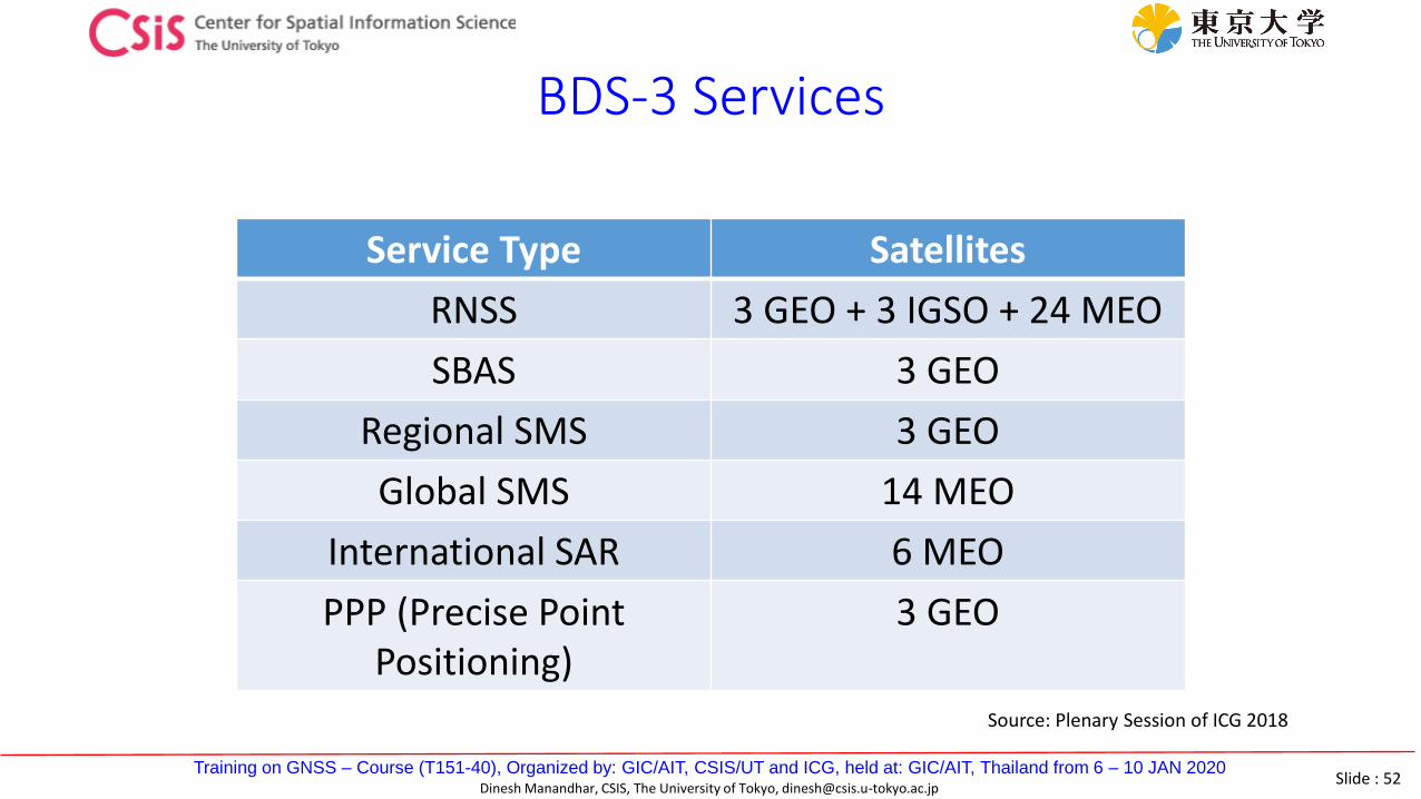
BDS-3 Services
Service Type Satellites
RNSS 3 GEO + 3 IGSO + 24 MEO
SBAS 3 GEO
Regional SMS 3 GEO
Global SMS 14 MEO
International SAR 6 MEO
PPP (Precise Point Positioning)
3 GEO
Source: Plenary Session of ICG 2018

Slide : 53Training on GNSS – Course (T151-40), Organized by: GIC/AIT, CSIS/UT and ICG, held at: GIC/AIT, Thailand from 6 – 10 JAN 2020
Dinesh Manandhar, CSIS, The University of Tokyo, [email protected]
QZSS / Michibiki, Japan(Quasi-Zenith Satellite System)

Slide : 54Training on GNSS – Course (T151-40), Organized by: GIC/AIT, CSIS/UT and ICG, held at: GIC/AIT, Thailand from 6 – 10 JAN 2020
Dinesh Manandhar, CSIS, The University of Tokyo, [email protected]
Merits of QZSS
• QZSS signal is designed in such a way that it is interoperable with GPS
• QZSS is visible near zenith; improves visibility & DOP in dense urban area
• Provides Orbit Data of other GNSS signals• Provides Augmentation Data for Sub-meter and
Centimeter level position accuracy• Provides Messaging System during Disasters
http://qzss.go.jp/en/overview/services/sv04_pnt.html

Slide : 55Training on GNSS – Course (T151-40), Organized by: GIC/AIT, CSIS/UT and ICG, held at: GIC/AIT, Thailand from 6 – 10 JAN 2020
Dinesh Manandhar, CSIS, The University of Tokyo, [email protected]
QZSS Development Plan
1st Satellite launched on 11th September 2010 : QZ Orbit2nd Satellite launched on 1st June 2017 : QZ Orbit3rd Satellite launched on 19th August 2017 : Geostationary Orbit
Information (number of satellites) in this slide are not updatedPlease check the following site for the latest updates: https://www.unoosa.org/oosa/en/ourwork/icg/annual-meetings.html
See file 06-QZSS_ICG_2019.pdf for the latest information as per DEC 2019

Slide : 56Training on GNSS – Course (T151-40), Organized by: GIC/AIT, CSIS/UT and ICG, held at: GIC/AIT, Thailand from 6 – 10 JAN 2020
Dinesh Manandhar, CSIS, The University of Tokyo, [email protected]
QZSS Constellation Status
• Current Status• One Satellite launched on 11th SEP 2010
• Total constellation of Seven Satellites• Three more satellites were launched by the end of 2017

Slide : 57Training on GNSS – Course (T151-40), Organized by: GIC/AIT, CSIS/UT and ICG, held at: GIC/AIT, Thailand from 6 – 10 JAN 2020
Dinesh Manandhar, CSIS, The University of Tokyo, [email protected]
QZSS Satellites & Signal Types
Signal Name
QZS-1 QZS-2 to QZS-4
Transmission serviceCenter
FrequencyMHz
Block IQ Block IIQ Block IIG
(QZO) (QZO) (GEO)
1 2 1
L1C/A ◎ ◎ ◎ Satellite positioning service
1575.42
L1C ◎ ◎ ◎ Satellite positioning service
L1SAIF ◎ Sub-meter Level Augmentation Service (SLAS) / Disaster and Crisis Management L1S ◎ ◎
L1Sb - - ◎SBAS Transmission Servicefrom around 2020
L2C ◎ ◎ ◎ Satellite positioning service 1227.60
L5 ◎ ◎ ◎ Satellite positioning service
1176.45L5S - ◎ ◎
Positioning Technology Verification Service
LEX ◎ MADOCA 1278.75
L6 ◎ ◎Centimeter Level Augmentation Service (CLAS)
S-band - - ◎ QZSS Safety Service / SAR 2GHz

Slide : 58Training on GNSS – Course (T151-40), Organized by: GIC/AIT, CSIS/UT and ICG, held at: GIC/AIT, Thailand from 6 – 10 JAN 2020
Dinesh Manandhar, CSIS, The University of Tokyo, [email protected]
QZSS Satellite Visibility
Source: SPAC Animation Video
Slide : 59Training on GNSS – Course (T151-40), Organized by: GIC/AIT, CSIS/UT and ICG, held at: GIC/AIT, Thailand from 6 – 10 JAN 2020
Dinesh Manandhar, CSIS, The University of Tokyo, [email protected]
QZSS New Applications

Slide : 60Training on GNSS – Course (T151-40), Organized by: GIC/AIT, CSIS/UT and ICG, held at: GIC/AIT, Thailand from 6 – 10 JAN 2020
Dinesh Manandhar, CSIS, The University of Tokyo, [email protected]
QZSS New Applications
• Short Message Broadcast during Emergencies and Disasters• L1SAIF L1S Signals
• Sub-meter Level Augmentation Service (SLAS)• L1SAIF L1S• L1Sb Signals
• Centimeter Level Augmentation Service (CLAS)• L6-D Signal
• PPP-RTK
• Multi-GNSS Advanced Demonstration tool for Orbit and Clock Analysis (MADOCA) • L6-E Signal
• PPP / PPP-AR

Slide : 61Training on GNSS – Course (T151-40), Organized by: GIC/AIT, CSIS/UT and ICG, held at: GIC/AIT, Thailand from 6 – 10 JAN 2020
Dinesh Manandhar, CSIS, The University of Tokyo, [email protected]
Short Message Broadcast during Disaster

Slide : 62Training on GNSS – Course (T151-40), Organized by: GIC/AIT, CSIS/UT and ICG, held at: GIC/AIT, Thailand from 6 – 10 JAN 2020
Dinesh Manandhar, CSIS, The University of Tokyo, [email protected]
Sub-meter Level Augmentation Service (SLAS)
SLAS : Sub-meter Level Augmentation ServiceSignal Used: L1SAIF / L1S

Slide : 63Training on GNSS – Course (T151-40), Organized by: GIC/AIT, CSIS/UT and ICG, held at: GIC/AIT, Thailand from 6 – 10 JAN 2020
Dinesh Manandhar, CSIS, The University of Tokyo, [email protected]
Centimeter Level Augmentation Service (CLAS)
CLAS : Centimeter Level Augmentation ServiceSignal Used: LEX: MADOCA & L6

Slide : 64Training on GNSS – Course (T151-40), Organized by: GIC/AIT, CSIS/UT and ICG, held at: GIC/AIT, Thailand from 6 – 10 JAN 2020
Dinesh Manandhar, CSIS, The University of Tokyo, [email protected]
NavIC / IRNSSNavigation with Indian Constellation
Indian Regional Navigation Satellite System

Slide : 65Training on GNSS – Course (T151-40), Organized by: GIC/AIT, CSIS/UT and ICG, held at: GIC/AIT, Thailand from 6 – 10 JAN 2020
Dinesh Manandhar, CSIS, The University of Tokyo, [email protected]
NavIC Signal Types
Signal Carrier Frequency
Bandwidth
L5 1176.45MHz 24MHz
S 2492.028MHz 16.5MHz
Please check the following site for the latest updates: https://www.unoosa.org/oosa/en/ourwork/icg/annual-meetings.html
See file 01_NAVIC_ICG_2019.pdf for the latest information as per DEC 2019

Slide : 66Training on GNSS – Course (T151-40), Organized by: GIC/AIT, CSIS/UT and ICG, held at: GIC/AIT, Thailand from 6 – 10 JAN 2020
Dinesh Manandhar, CSIS, The University of Tokyo, [email protected]
NavIC (Navigation with Indian Constellation)
• Consists of 7 Satellites
• 4 Geo Synchronous Orbit (GSO) satellites• at 55oE and 111.75oE at an inclination of 27o
• 3 Geo Stationary Satellites (GEO)• at 32.5oE, 83oE and 129.5o E at an inclination of 5o
• Transmits signals in L5 band (1176.45MHz) and S band (2492.028MHz)
Please check the following site for the latest updates: https://www.unoosa.org/oosa/en/ourwork/icg/annual-meetings.html

Slide : 67Training on GNSS – Course (T151-40), Organized by: GIC/AIT, CSIS/UT and ICG, held at: GIC/AIT, Thailand from 6 – 10 JAN 2020
Dinesh Manandhar, CSIS, The University of Tokyo, [email protected]
NavIC Space Segment
• All Seven Satellites are successfully realized in orbit
• IRNSS-1A (1 July 2013) IRNSS-1B (4 Apr 2014)
• IRNSS-1C (10 Nov 2014) IRNSS-1D (28 Mar 2015)
• IRNSS-1E (20 Jan 2016) IRNSS-1F (10 Mar 2016)
• IRNSS-1G (28 Apr 2016) IRNSS-1I (12 Apr 2018)
Slide : 68Training on GNSS – Course (T151-40), Organized by: GIC/AIT, CSIS/UT and ICG, held at: GIC/AIT, Thailand from 6 – 10 JAN 2020
Dinesh Manandhar, CSIS, The University of Tokyo, [email protected]
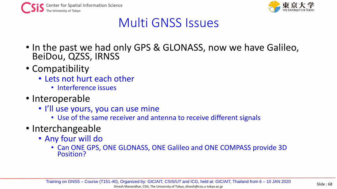
Multi GNSS Issues
• In the past we had only GPS & GLONASS, now we have Galileo, BeiDou, QZSS, IRNSS
• Compatibility• Lets not hurt each other
• Interference issues
• Interoperable• I’ll use yours, you can use mine
• Use of the same receiver and antenna to receive different signals
• Interchangeable• Any four will do
• Can ONE GPS, ONE GLONASS, ONE Galileo and ONE COMPASS provide 3D Position?

Slide : 69Training on GNSS – Course (T151-40), Organized by: GIC/AIT, CSIS/UT and ICG, held at: GIC/AIT, Thailand from 6 – 10 JAN 2020
Dinesh Manandhar, CSIS, The University of Tokyo, [email protected]
Multi-GNSS SignalsL1 / E1L2L5 / E5 L6 / E6 S

Slide : 70Training on GNSS – Course (T151-40), Organized by: GIC/AIT, CSIS/UT and ICG, held at: GIC/AIT, Thailand from 6 – 10 JAN 2020
Dinesh Manandhar, CSIS, The University of Tokyo, [email protected]
Multi GNSS Signals: Benefits to Users
• GPS+GLONASS+Galileo+COMPASS+IRNSS+QZSS
• Asia-Oceanic region will see the maximum number of satellites

Slide : 71Training on GNSS – Course (T151-40), Organized by: GIC/AIT, CSIS/UT and ICG, held at: GIC/AIT, Thailand from 6 – 10 JAN 2020
Dinesh Manandhar, CSIS, The University of Tokyo, [email protected]
Multi GNSS Signals: Benefits to Users
• Increase in usable SVs, signals and frequencies• Increase in availability and coverage• More robust and reliable services• Higher accuracy in bad conditions• Less expensive high-end services• Better atmospheric correction
• Emerging new and expanding existing applications are to be expected
• Atmosphere related applications• Short Message Broadcasting• SAR (Search And Rescue Applications)• Bi-static Remote Sensing
• Compute Soil Moisture, Wind Velocity, Sea Wave Height etc…