introduction to integrate modules: hands-on, data-rich, and socially-relevant geoscience activities
TRANSCRIPT

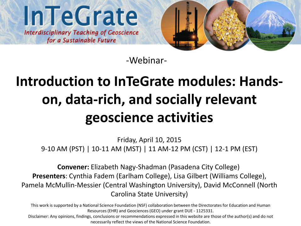
-Webinar-
Introduction to InTeGrate modules: Hands-on, data-rich, and socially relevant
geoscience activities
Friday, April 10, 20159-10 AM (PST) | 10-11 AM (MST) | 11 AM-12 PM (CST) | 12-1 PM (EST)
Convener: Elizabeth Nagy-Shadman (Pasadena City College)Presenters: Cynthia Fadem (Earlham College), Lisa Gilbert (Williams College),
Pamela McMullin-Messier (Central Washington University), David McConnell (North Carolina State University)
This work is supported by a National Science Foundation (NSF) collaboration between the Directorates for Education and Human Resources (EHR) and Geociences (GEO) under grant DUE - 1125331.
Disclaimer: Any opinions, findings, conclusions or recommendations expressed in this website are those of the author(s) and do not necessarily reflect the views of the National Science Foundation.

Elizabeth Nagy-ShadmanPasadena City College
John McDarisScience Education Resource
Center (SERC) at Carleton College
Lisa GilbertWilliams College
David McConnellNorth Carolina State University
Pamela McMullin-MessierCentral Washington University
Cynthia FademEarlham College

• Introduce college and university part-time and full-time faculty to InTeGrate modules
Webinar Goals
• Describe additional opportunities related to using InTeGrate materials in your classroom
• Hear directly from module authors about their classroom experiences and allow participants to ask questions

1. What is InTeGrate and how were the modules developed?2. Overview of modules 3. MODULE: Natural Hazards and Risks: Hurricanes4. MODULE: Map Your Hazards! Assessing Hazards,
Vulnerability, and Risk 5. MODULE: Climate of Change: Interactions and Feedbacks
between Water, Air, and Ice6. Upcoming opportunities7. Questions from Participants
Webinar Outline

A five-year community effort to improve geoscience literacy and build
a workforce prepared to tackle environmental and resource issues
http://serc.carleton.edu/integrate
What is InTeGrate?
2012-2016InTeGrate Leadership team, March 2013
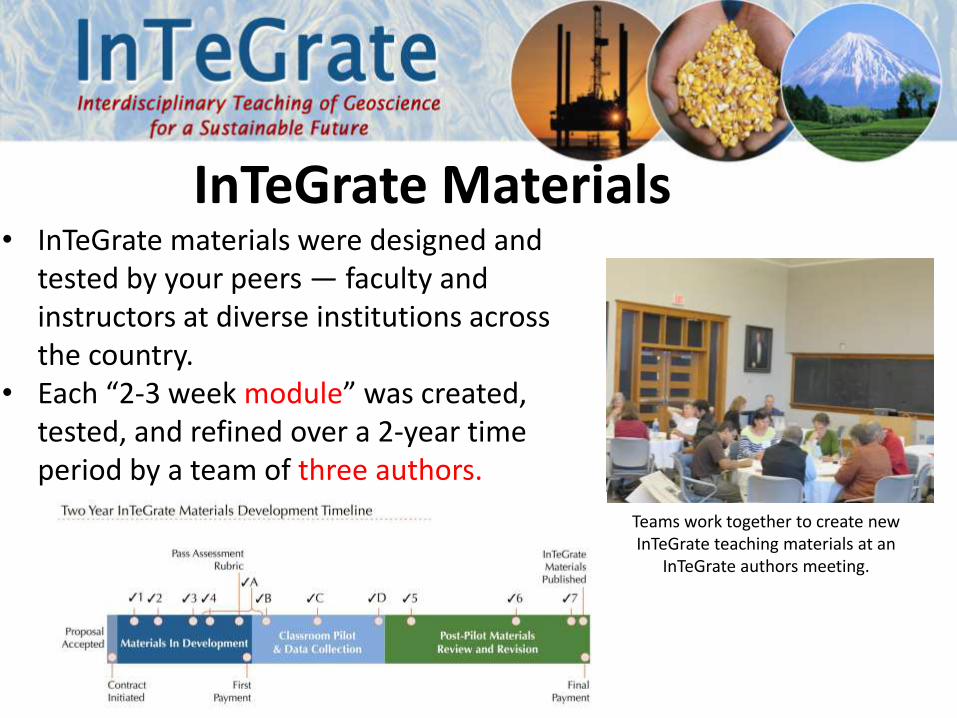
• InTeGrate materials were designed and tested by your peers — faculty and instructors at diverse institutions across the country.
• Each “2-3 week module” was created, tested, and refined over a 2-year time period by a team of three authors.
InTeGrate Materials
Teams work together to create new InTeGrate teaching materials at an
InTeGrate authors meeting.

• Materials were designed to be adaptable to a wide variety of classrooms and settings: • community college• large research institution• online• in a large lecture hall• small seminar
• Activities focus on engaging students in hands-on learning.
InTeGrate MaterialsStudents in jigsaw group.
Students doing a
gallery walk.

1. What is InTeGrate and how were the modules developed?2. Overview of modules 3. MODULE: Natural Hazards and Risks: Hurricanes4. MODULE: Map Your Hazards! Assessing Hazards,
Vulnerability, and Risk 5. MODULE: Climate of Change: Interactions and Feedbacks
between Water, Air, and Ice6. Upcoming opportunities7. Questions from Participants
Webinar Outline

InTeGrate Modules
• Climate of Change: Interactions and Feedbacks between Water, Air and Ice
• Natural Hazards and Risks: Hurricanes• Exploring Geoscience Methods • Humans' Dependence on Earth's Mineral Resources• A Growing Concern: Sustaining Soil Resources through
Local Decision Making• Map Your Hazards! – Assessing Hazards, Vulnerability
and Risk• Interactions between Water, Earth's Surface, and
Human Activity

Well-designed, high quality materialsHumans’
Dependence onEarth’s Mineral
Resources
A Growing Concern: Sustaining Soil Resources through Local Decision Making
Interactions between Water, Earth's Surface, and Human Activity
Exploring Geoscience
Methods

Upcoming InTeGrateModules
• Carbon, Climate, and Energy Resources• Changing Biosphere• Environmental Justice and Freshwater Resources• Global Energy and the Atmosphere• Gateway to Renewable Energy and Environmental
Sustainability (GREENS)• Mapping the Environment with Sensory Perception• Water Sustainability in Cities• Food Security Module• Coastal Processes Hazards and Society• Ocean Sustainability

InTeGrate Home pagehttp://serc.carleton.edu/integrate/index.html

InTeGrate Home pagehttp://serc.carleton.edu/integrate/index.html

Published Modules

Published Modules

Published Modules

Module Features – Home page
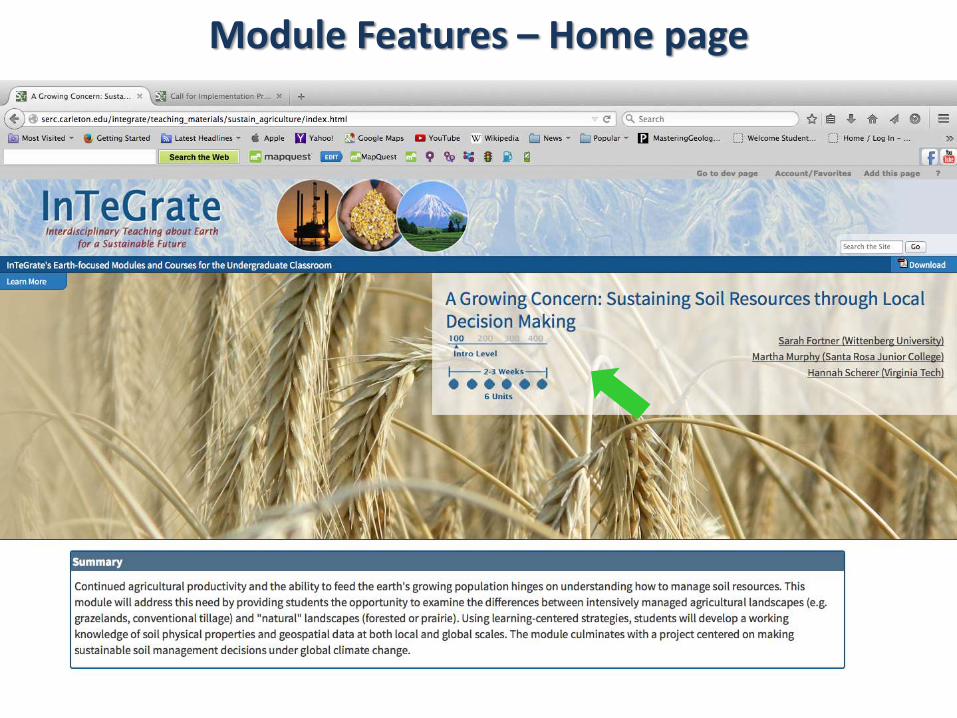
Module Features – Home page

Module Features – Home page
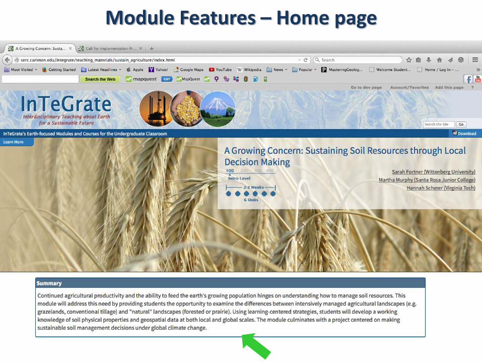
Module Features – Home page
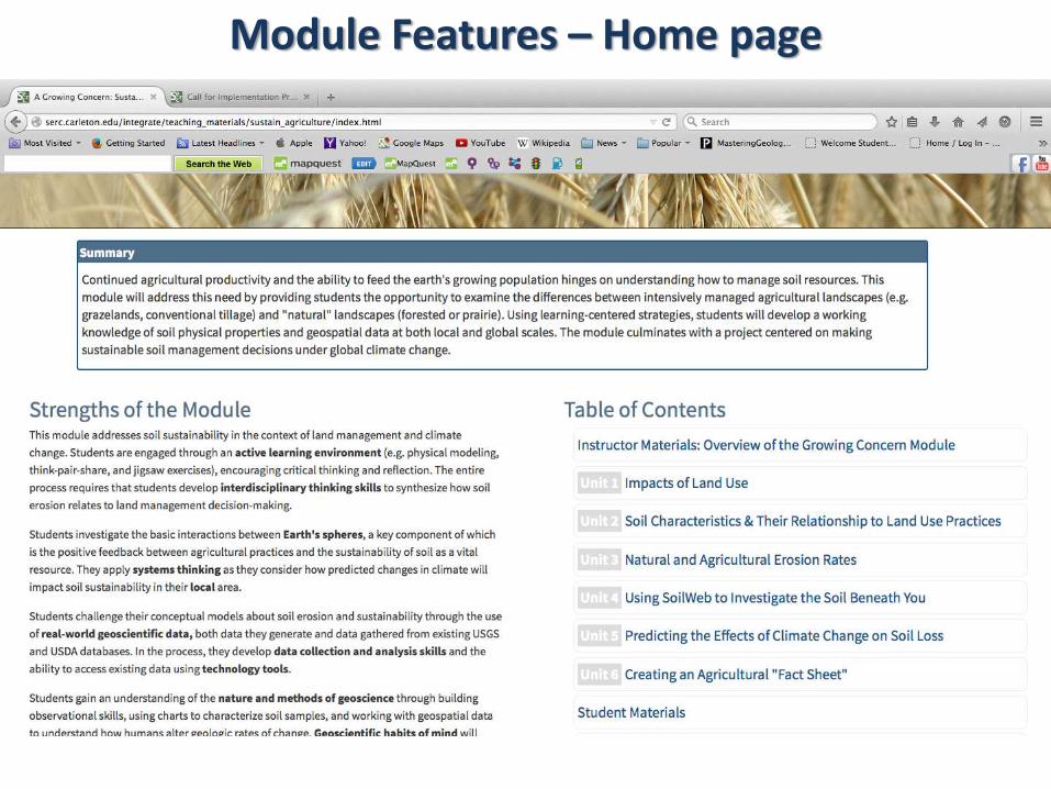
Module Features – Home page

Module Features – Home page

Module Features – Home page

Module Features – Home page

Module Features – Home page

Module Features – Home page

Module Features – Home page

Module Features – Home page

Module Features – Home page

Module Features – Home page

Module Features – Home page

The Geoscience Literacy Documents

Module Features – Home page

Module Features – Home page
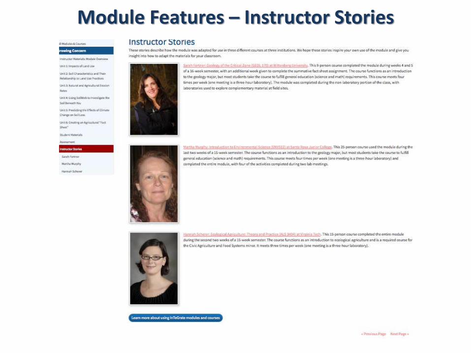
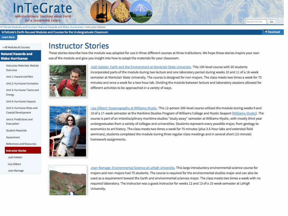
Module Features – Instructor Stories

Module Features – Instructor Stories

Module Features – Instructor Stories

Module Features – Instructor Stories

1. What is InTeGrate and how were the modules developed?2. Overview of modules 3. MODULE: Natural Hazards and Risks: Hurricanes4. MODULE: Map Your Hazards! Assessing Hazards,
Vulnerability, and Risk 5. MODULE: Climate of Change: Interactions and Feedbacks
between Water, Air, and Ice6. Upcoming opportunities7. Questions from Participants
Webinar Outline

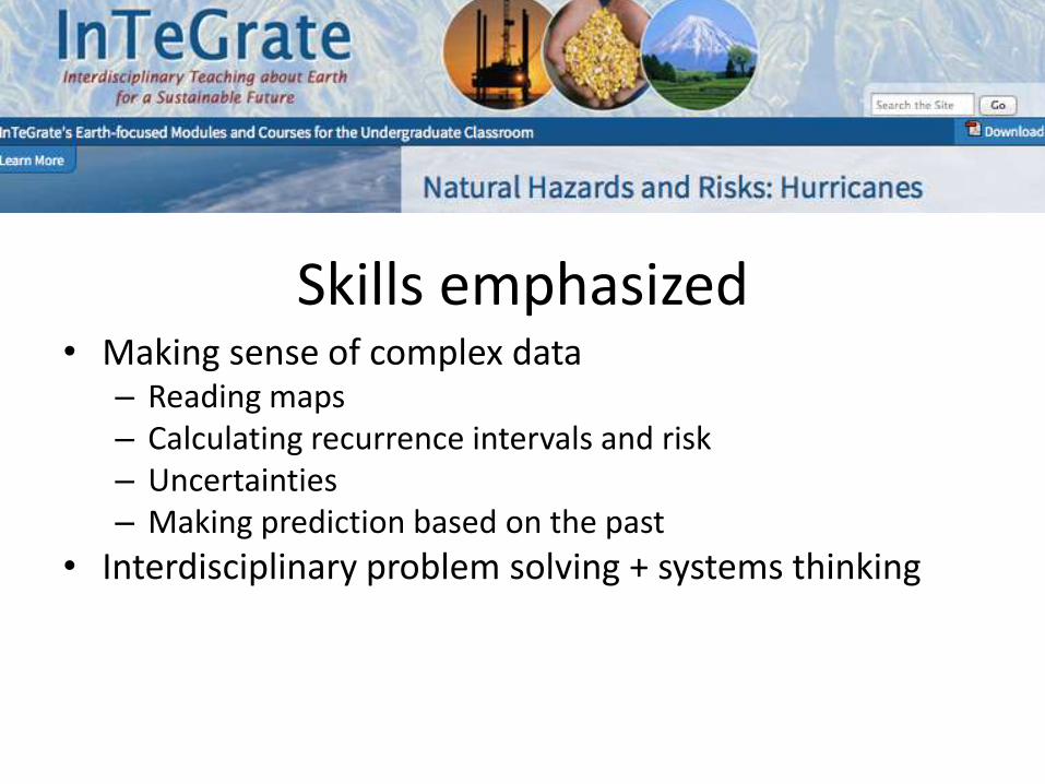
Skills emphasized • Making sense of complex data
– Reading maps– Calculating recurrence intervals and risk– Uncertainties– Making prediction based on the past
• Interdisciplinary problem solving + systems thinking


Sample class period:
Activity 1.1: (5-10 minutes)THINK-PAIR-SHARE – Cartoon of plane flying over a volcano to introduce the difference between hazard & risk, and to begin brainstorming risk mitigations.
Activity 1.2: (10-20 minutes)DISCUSSION based on New York Times article about daily risk.
Activity 1.3: (20 minutes)USING DATA – Students work in groups to calculate risk and insurance costs for a house in their own coastal county.


(NOAA)

System feedbacks: land-ocean-atmosphere-society
Ft. Lauderdale, Florida. Each image is approximately 1 mile wide. Image on the left is from 1947 (USDA, from ufdc.ufl.edu).Image on the right is from 2008 (The National Map, USGS, nationalmap.gov).


• Prepare:
– Read article and generate a list of stakeholders
– Discuss video of “peer” evacuation stories
• Evacuation debate Making the difficult decision of whether or not to
evacuate our town
Please consider: Do you think a mandatory evacuation order should be issued? Give both pros and
cons. Does timing matter? How much time do you reasonably need to prepare for
evacuation? How soon is too soon? Below, draft your Position Statement as ____________________________ ______________:
(stakeholder)
The scenario:
• It’s Wednesday morning and a Category 2-3 hurricane is
predicted to make landfall here Sunday.
• The mayor is hearing statements today.

1. What is InTeGrate and how were the modules developed?2. Overview of modules 3. MODULE: Natural Hazards and Risks: Hurricanes4. MODULE: Map Your Hazards! Assessing Hazards,
Vulnerability, and Risk 5. MODULE: Climate of Change: Interactions and Feedbacks
between Water, Air, and Ice6. Upcoming opportunities7. Questions from Participants
Webinar Outline
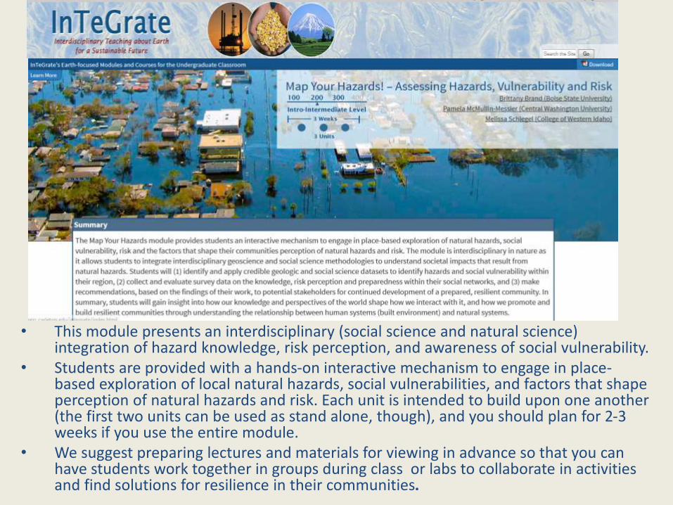
• This module presents an interdisciplinary (social science and natural science) integration of hazard knowledge, risk perception, and awareness of social vulnerability.
• Students are provided with a hands-on interactive mechanism to engage in place-based exploration of local natural hazards, social vulnerabilities, and factors that shape perception of natural hazards and risk. Each unit is intended to build upon one another (the first two units can be used as stand alone, though), and you should plan for 2-3 weeks if you use the entire module.
• We suggest preparing lectures and materials for viewing in advance so that you can have students work together in groups during class or labs to collaborate in activities and find solutions for resilience in their communities.

Our motivations for creating the module…• In earlier classroom experiences, we found that a lack of accurate knowledge of
regional natural hazards corresponded to a low perception of risk associated with these hazards, even among those who had grown up or had lived within the region.
• This established a demonstrated need for preparedness. Bridging this communication gap is critical in creating a culture of safety rather than moments of reaction.
• Assessments of the module found:– illustration of an increase in the students' interest and level of engagement with
material on hazards; – demonstration of knowledge and interpretation of survey data collected within the
student community.

An excellent source to explore vulnerability without having to use GIS is the EPA mapping program: EJ View To find a map for your location, you can enter a zip code, city or county. Then click on "Select Map Contents" and select "Demographics (ACS) 2010" and click on a variable that you would like to examine.

• Using the survey tool is a great opportunity for students to integrate geoscience and social science methodologies to understand societal impacts that result from natural hazards.
• This allows students develop hypotheses and analyze the data to assess:• Hazard Knowledge• Vulnerability/Risk Perception• Level of Preparedness

• Hazard professionals are interested and may want to talk to your class about your findings or offer context for mitigation strategies. Think ahead of the module in extending invitations to professionals, as time permits.
• This final part of the module is where students synthesize their findings from the previous units essentially into an action plan. We suggest at least two dedicated class periods to work on the presentations as students will need time to practice and get feedback from their peers and the instructor.
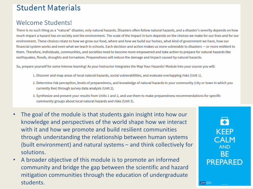
• The goal of the module is that students gain insight into how our knowledge and perspectives of the world shape how we interact with it and how we promote and build resilient communities through understanding the relationship between human systems (built environment) and natural systems – and think collectively for solutions.
• A broader objective of this module is to promote an informed community and bridge the gap between the scientific and hazard mitigation communities through the education of undergraduate students.


1. What is InTeGrate and how were the modules developed?2. Overview of modules 3. MODULE: Natural Hazards and Risks: Hurricanes4. MODULE: Map Your Hazards! Assessing Hazards,
Vulnerability, and Risk 5. MODULE: Climate of Change: Interactions and Feedbacks
between Water, Air, and Ice6. Upcoming opportunities7. Questions from Participants
Webinar Outline

Developed and tested May 2012-May 2013; published June 2014
Climate of Change:
Interactions & Feedbacks Between Air,
Water, & Ice
Cindy Shellito, University of Northern ColoradoBecca Walker, Mt. San Antonio College
Cynthia Fadem, Earlham College

Module goal: Analyze climate data and evaluate how interactions between climate system components lead to climate variability that impacts human societies.
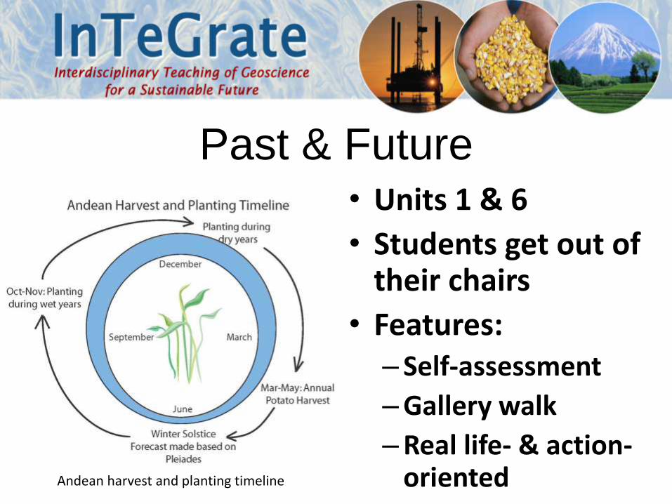
Andean harvest and planting timeline
Past & Future• Units 1 & 6
• Students get out of their chairs
• Features:– Self-assessment
–Gallery walk
–Real life- & action-oriented

• Units 2 & 3
• Students discover anomalies.
• Features:
– Jigsaw
–Map reading & mapping
– Emphasizes connections between water & atmosphere
Ocean
SST & wind
Pressure
Precip-itation
Students characterize
phases of ENSO
Students characterize
phases of ENSO
rearra
ng
e g
rou
ps

Byrd Polar Research Center
Glacier• Unit 4
• Students analyze albedo & loss.
• Features:– Jigsaw
–Quantitative data
– Emphasizes connections between ice & atmosphere
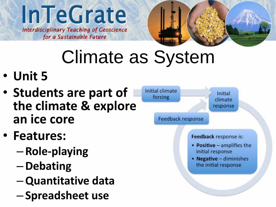
Climate as System• Unit 5• Students are part of
the climate & explore an ice core
• Features:–Role-playing–Debating–Quantitative data– Spreadsheet use

Implementation Tips
• Concepts to weave throughout: feedback, uncertainty, anomaly, connections
• Class size issues: collaboration, peer assessment, minor modification
• Logistical concerns: color displays, handouts, assessment
• Stay positive

1. What is InTeGrate and how were the modules developed?2. Overview of modules 3. MODULE: Natural Hazards and Risks: Hurricanes4. MODULE: Map Your Hazards! Assessing Hazards,
Vulnerability, and Risk 5. MODULE: Climate of Change: Interactions and Feedbacks
between Water, Air, and Ice6. Upcoming opportunities7. Questions from Participants
Webinar Outline

Call for Proposals to Assess Incorporation of InTeGrate Module materials in Introductory Courses
• Team of up to 12 instructors for research project.
• Compare and contrast student performance and attitudes in a course taught with and without InTeGrate materials.
• Revised courses feature at least the equivalent of three InTeGrate modules of materials (18 units or ~6 weeks).
Potential InTeGrate Module materials: • Climate of change: Interactions and Feedbacks between Water, Air and Ice• Natural Hazards & Risks: Hurricanes• Humans’ Dependence on Earth’s Mineral Resources• A Growing Concern: Sustaining Soil Resources• Map Your Hazards! Assessing Hazards Vulnerability & Risk• Living on the Edge: Building resilient societies on active plate margins• Environmental Justice & Freshwater Resources

Call for Proposals to Assess Incorporation of InTeGrate Module materials in Introductory Courses
Application deadline: April 17, 2015
Participants stipend of $5000 to:
• Attend a summer workshop (June 14-18, 2015), Carleton College, Northfield, MN.
• Collect standard InTeGrate student demographic data and data from student performance on embedded assessments.
• Complete pre/post surveys and interviews conducted by InTeGrate personnel.
• Participate in classroom observations (live or by video).
• Write an "Instructor Story" describing their experience using the InTeGrate materials.

Call for Proposals to Assess Incorporation of InTeGrate Module materials in Introductory Courses
For more information visit
http://serc.carleton.edu/integrate/participate/2015call_research.html
Any Questions?
Proposals are relatively brief documents that include:
1. A description of the contents of the course. Include a recent syllabus, if available.
2. A description of the student population in the course.
3. A description of your current pedagogical approach to teaching the course (discussion of any in-class activities, characteristics of exams).
4. Please indicate which module topics would be most readily incorporated into your target course.
Application deadline: April 17, 2015

UPCOMING OPPORTUNITIES

July 13-17, 2015 | University of Colorado, Boulder
Earth Educators’ Rendezvous 2015
http://serc.carleton.edu/earth_rendezvous/2015/index.html
• Brings together researchers and practitioners working in all aspects of undergraduate Earth education
• Program consists of 27 workshops, 4 plenary talks, and more than 150 contributed presentations (oral and poster sessions)
• AM workshop (July 16, 17): Teaching with InTeGrate Materials in a 2YC Environment

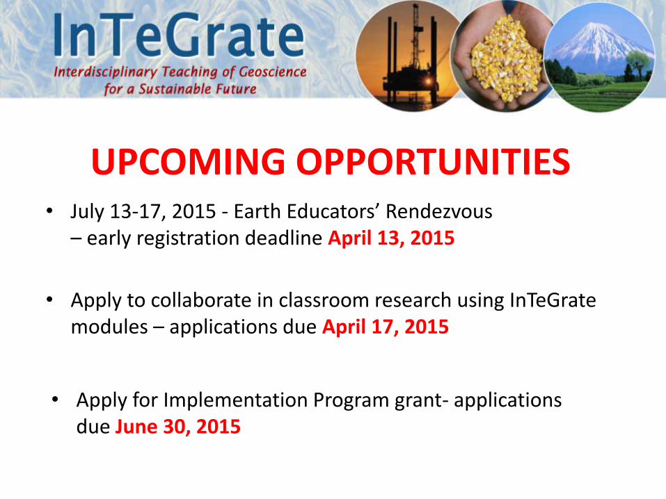
UPCOMING OPPORTUNITIES• July 13-17, 2015 - Earth Educators’ Rendezvous
– early registration deadline April 13, 2015

UPCOMING OPPORTUNITIES• July 13-17, 2015 - Earth Educators’ Rendezvous
– early registration deadline April 13, 2015
• Apply to collaborate in classroom research using InTeGratemodules – applications due April 17, 2015

• Go to InTeGrate home page• Click on “Learn more about InTeGrate”• Click on “Implementation Programs” on left-hand menu

http://serc.carleton.edu/integrate/workshops/2yc_webinar2/index.html
UPCOMING OPPORTUNITIES• July 13-17, 2015 - Earth Educators’ Rendezvous
– early registration deadline April 13, 2015
• Apply for Implementation Program grant- applications due June 30, 2015
• Apply to collaborate in classroom research using InTeGratemodules – applications due April 17, 2015

1. What is InTeGrate and how were the modules developed?2. Overview of modules 3. MODULE: Natural Hazards and Risks: Hurricanes4. MODULE: Map Your Hazards! Assessing Hazards,
Vulnerability, and Risk 5. MODULE: Climate of Change: Interactions and Feedbacks
between Water, Air, and Ice6. Upcoming opportunities7. Questions from Participants
Webinar Outline
-Webinar-
Introduction to InTeGrate modules: Hands-on, data-rich, and socially relevant
geoscience activities
Friday, April 10, 20159-10 AM (PST) | 10-11 AM (MST) | 11 AM-12 PM (CST) | 12-1 PM (EST)
Convener: Elizabeth Nagy-Shadman (Pasadena City College)Presenters: Cynthia Fadem (Earlham College), Lisa Gilbert (Williams College),
Pamela McMullin-Messier (Central Washington University), David McConnell (North Carolina State University)
This work is supported by a National Science Foundation (NSF) collaboration between the Directorates for Education and Human Resources (EHR) and Geociences (GEO) under grant DUE - 1125331.
Disclaimer: Any opinions, findings, conclusions or recommendations expressed in this website are those of the author(s) and do not necessarily reflect the views of the National Science Foundation.