introduction to remote sensingnceg.uop.edu.pk/workshop-21-26-09/lectureslides/day4/... ·...
TRANSCRIPT

INTRODUCTION TO REMOTE SENSINGINTRODUCTION TO REMOTE SENSING
Ghazanfar A. KhattakNational Centre of Excellence in Geology
University of Peshawar
WHAT IS REMOTE SENSING?WHAT IS REMOTE SENSING?
Remote sensing is the science of acquiring Remote sensing is the science of acquiring information about the Earth's surface without actually being in contact with it. actually being in contact with it.

REMOTE SENSINGREMOTE SENSING
is the science and art of acquiring f q ginformation (spectral, spatial, temporal) about material objects, area, or about material objects, area, or phenomenon through the analysis of data acquired by a device from measurements acquired by a device from measurements made at a distance, without coming into
h i l t t ith th bj t physical contact with the objects, area, or phenomena under investigation.

HOW DOES REMOTE SENSING WORK?HOW DOES REMOTE SENSING WORK?
Remote Sensing is performed by sensing and Remote Sensing is performed by sensing and recording reflected or emitted energy and processing, analyzing, and applying that processing, analyzing, and applying that information".

REMOTE SENSING OVERVIEWREMOTE SENSING OVERVIEW
Observation without direct contact.Observation without direct contact.

PASSIVE REMOTE SENSINGPASSIVE REMOTE SENSING
makes use of sensors that detect the reflected or emitted electro-magnetic radiation from magnetic radiation from natural sources.

ACTIVE REMOTE SENSINGACTIVE REMOTE SENSING
makes use of sensors that detect freflected responses from objects that are irradiated from that are irradiated from artificially-generated energy
h dsources, such as radar.

WHAT IS EMR?WHAT IS EMR?
Electromagnetic Radiation is a form of energy Electromagnetic Radiation is a form of energy with the properties of a wave.

WHAT IS EMR?WHAT IS EMR?
The waves propagate through time and space The waves propagate through time and space in a manner rather like water waves, but oscillate in all directions perpendicular to their oscillate in all directions perpendicular to their direction of travel.

ELECTROMAGNETIC WAVESELECTROMAGNETIC WAVES
A wave is characterized by two principal A wave is characterized by two principal measures: wavelength and frequency:
The wavelength (lambda) is the distance in The wavelength (lambda) is the distance in meters between successive crests of the waves waves.
The frequency (nu) is the number of oscillations completed per second.

ELECTROMAGNETIC WAVESELECTROMAGNETIC WAVES

TERMSTERMS
• Crest : The highest point of the wave. g
• Trough : The lowest point of the wave.
• Amplitude : The height of the wave as measured between the trough and the crest.
• Wavelength : The distance between two Wavelength : The distance between two identical points on the wave.
• Period : The time it takes for a wavelength to pass a stationar point to pass a stationary point.
• Frequency : The number of wavelengths that pass a point in a set period of time. p p p

WAVELENGTHWAVELENGTH
The wavelength (lambda) is the distance in The wavelength (lambda) is the distance in metres between successive crests of the waves. waves.

ELECTROMAGNETIC WAVESELECTROMAGNETIC WAVES

FREQUENCYFREQUENCY
The frequency (nu) is the number of oscillations The frequency (nu) is the number of oscillations completed per second.

ELECTROMAGNETIC WAVESELECTROMAGNETIC WAVES

WAVELENGTH AND FREQUENCYWAVELENGTH AND FREQUENCY
Wavelength and frequency are related by the Wavelength and frequency are related by the following formula:

WHAT CAN SATELLITES SEE?WHAT CAN SATELLITES SEE?
Satellite electromagnetic sensors let us “see” beyond the visibleSatellite electromagnetic sensors let us see beyond the visible..

ELECTROMAGNETIC SPECTRUMELECTROMAGNETIC SPECTRUM
ELECTROMAGNETIC INTERACTIONSELECTROMAGNETIC INTERACTIONS
EMR that interacts with an object is called EMR that interacts with an object is called incident radiation

Electromagnetic energy is either, reflected, transmitted, or absorbed
by the surface it strikes.

The Major Components Of Remote-sensing Technology
1. ENERGY SOURCE (PASSIVE SYSTEM: sun, irradiance from earth’s materials;ACTIVE SYSTEM: irradiance from artificially-generated energy sources such as radar)
( h l h ) ( k f h l ll )2. PLATFORMS (Vehicle to carry the sensor) (truck, aircraft, space shuttle, satellite, etc.)
3. SENSORS (Device to detect electro-magnetic radiation) (camera, scanner, etc)
4 C O S (T l i di i i d d i l ) (fil ili4. DETECTORS (To convert electro-magnetic radiation into recorded signals) (film, silicondetectors, etc)
5. PROCESSING (Handling signal data) ( photographic, digital, etc)
6. INSTITUTIONALISATION (Organization for execution at all stages of remote-sensing technology: international and national organizations, centers, universities,etc

The vehicles or carriers for remote sensors are called the platforms. Typical examples are called the platforms. Typical examples of platforms are satellites and aircraft, but they can also include radio-controlled aeroplanes, balloons, kits for low altitude remote sensing, as well as ladder trucks or ‘cherry pickers’ for ground investigations. The key factor for the selection of a platform is the altitude that determines the ground is the altitude that determines the ground resolution and which is also dependent on the instantaneous field of view (IFOV) of the ( )sensor on board the platform.

Orbit Elevation PlatformsOrbit Elevation
36,000 km
PlatformsGMS(Geostationary Satellite)
1,000km500km
LANDSAT, MOS,SPOT
240 - 350 km
SPACE SHUTTLE
HIGH ALTITUDEJETPLANE
10,000 - 12,000m LOW&MIDDLEALTITUDEAIRPLANE
JETPLANE
GROUND TRUTH1,200 - 3,500m

Platform Altitude Observationgeostationary satellite 36,000km fixed point observation
circular orbit satellite 500km - 1 000km regular observationcircular orbit satellite(earth observation)
500km - 1,000km regular observation
space shuttle 240km - 350km irregular observation space experiment
radio - sound 100m - 100km various investigations (meteorological,etc)
high altitude jet-plane 10km -12km reconnaissanceg j pwide area investigations
low or middle altitude plane 500m - 8,000m various aero investigation surveys
helicopter 100m- 2,000m various aero investigation surveys
radio-controlled plane below 500m various aero investigation surveys
hang-plane 50 - 500m various aero investigation surveys
hang-balloon 800m - various investigations
cable 10 - 40m archaeological investigations
crane car 5 50m close range surveyscrane car 5 - 50m close range surveys
ground measurement car 0 - 30m ground truth
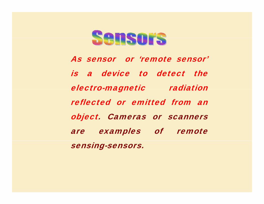
As sensor or ‘remote sensor’is a device to detect theelectro-magnetic radiationelectro magnetic radiationreflected or emitted from an
bj t Cobject. Cameras or scannersare examples of remotesensing-sensors.

PassiveNon-scanning
Non-imagingMicrowave Radiometer Magnetic SensorGravimeterFourier SpectrometerOther
Imaging Camera
MonochromeNatural colorInfraredOther
ScanningScanningImaging
Image Plane ScanningTV CameraSolid Scanner
Object Plane ScanningOptical Mechanical ScannerMicrowave Radiometer

Continued ….. Classification of Sensorsf f
ActiveActiveNon-scanning
Non-imagingMicrowave RadiometerMicrowave RadiometerLaser Water Depth meter Laser Distance meter
S iScanningImaging
Object Plane Scanning Real Aperture Radar Real Aperture Radar Synthetic Aperture Radar Image Plane ScanningPassive Phased Array Radar
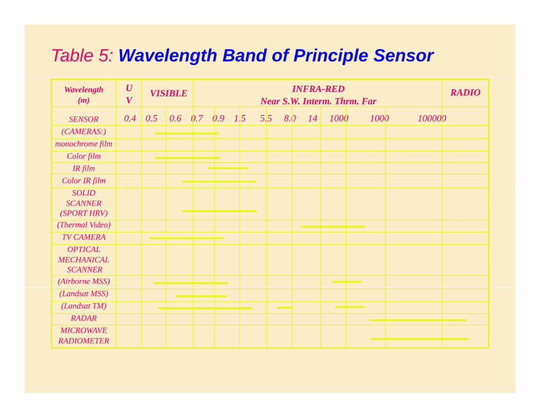
Table 5: Wavelength Band of Principle Sensor
Wavelength (m)
SENSOR(CAMERAS )
0.4 0.5 0.6 0.7 0.9 1.5 5.5 8.0 14 1000 1000 100000
UV
VISIBLE INFRA-REDNear S.W. Interm. Thrm. Far
RADIO
(CAMERAS:)monochrome film
Color filmIR film
Color IR filmColor IR filmSOLID
SCANNER(SPORT HRV)
(Thermal Video)TV CAMERATV CAMERA
OPTICAL MECHANICAL
SCANNER(Airborne MSS)(Landsat MSS)(Landsat TM)
RADARMICROWAVE
RADIOMETERRADIOMETER


HOW DO IMAGING SATELLITES WORK? HOW DO IMAGING SATELLITES WORK?
Satellite electromagnetic sensors “see” reflected and emitted radiationSatellite electromagnetic sensors see reflected and emitted radiation

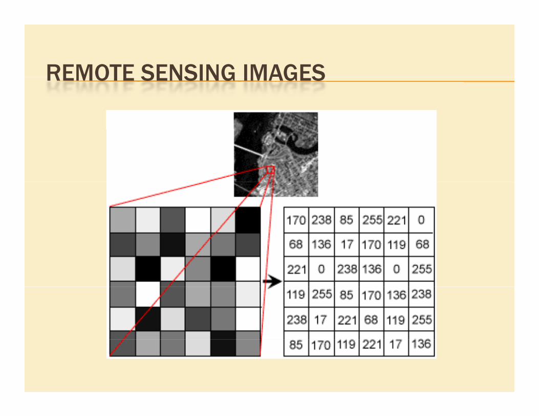
REMOTE SENSING IMAGESREMOTE SENSING IMAGES

COLOR COMPOSITE IMAGES

MULTISPECTRAL REMOTE SENSING IMAGESMULTISPECTRAL REMOTE SENSING IMAGES

REMOTE SENSING APPLICATIONSREMOTE SENSING APPLICATIONS
• Archaeology• Agriculture• Agriculture• Cartography
• Civil Engineering• Climatology
C l S di• Coastal Studies• Emergency Response
• Forestry• Geology• Hazards• Land-Use
• Meteorology• Natural Disasters• Oceanography
• Water Resources

AGRICULTURAL APPLICATIONSAGRICULTURAL APPLICATIONS
• crop type classification p yp
• crop condition assessment
crop yield estimation • crop yield estimation
• mapping of soil characteristics
• mapping of soil management practices
• compliance monitoring (farming practices)
• precision farming

AGRICULTURAL EXAMPLE AGRICULTURAL EXAMPLE

CROPS MONITORING (TORNADO DAMAGE)CROPS MONITORING (TORNADO DAMAGE)

PRECISION AGRICULTUREPRECISION AGRICULTURE

FORESTRY APPLICATIONSFORESTRY APPLICATIONS
• forest cover type discrimination yp• clear cut mapping / regeneration assessment • burn delineation • burn delineation • infrastructure mapping / operations support • forest inventory • forest inventory • biomass estimation
species inventory • species inventory • forest health and vigour

FOREST BURNSFOREST BURNS

GEOLOGICAL APPLICATIONS• surficial deposit / bedrock mapping
• lithological mapping
• structural mapping
• sand and gravel (aggregate) exploration/ exploitation
• mineral exploration
hydrocarbon exploration • hydrocarbon exploration
• environmental geology
• sedimentation mapping and monitoring pp g g
• geo-hazard mapping

STRUCTURAL MAPPING STRUCTURAL MAPPING

GEOLOGICAL UNIT MAPPINGGEOLOGICAL UNIT MAPPING

Dana Hilltop
Large LakeKarli Nulla
Small LakeTung Nulla
IKONOS,

HYDROLOGICAL APPLICATIONSHYDROLOGICAL APPLICATIONS
• wetlands mapping and monitoring,
• soil moisture estimation,
• snow pack monitoring,
• measuring snow thickness,
• river and lake ice monitoring,
flood mapping and monitoring • flood mapping and monitoring,
• glacier dynamics monitoring
• drainage basin mapping and watershed modelling g pp g g
• irrigation mapping


FLOODS AND DISASTER RESPONSEEXAMPLE

LAND-USE LAND-COVER APPLICATIONSLAND USE LAND COVER APPLICATIONS
• natural resource management
• wildlife habitat protection
• urban expansion / encroachment
• damage delineation (tornadoes, flooding, volcanic, seismic, fire)
• legal boundaries for tax and property evaluation
• target detection - identification of landing strips, d l i b id l d/ i f roads, clearings, bridges, land/water interface

LAND COVER CLASSIFICATION LAND COVER CLASSIFICATION

SPECIES MAPPINGSPECIES MAPPING

MAPPING APPLICATIONSMAPPING APPLICATIONS
planimetryplanimetry
Digital elevation models (DEM's)
baseline thematic mapping
Topographic mapping

PLANIMETRIC MAPPINGPLANIMETRIC MAPPING

DIGITAL ELEVATION MODELSDIGITAL ELEVATION MODELS

TOPOGRAPHIC MAPPINGTOPOGRAPHIC MAPPING

OCEAN APPLICATIONSOCEAN APPLICATIONS
• Ocean pattern identification:
• Storm forecasting
• Fish stock and marine mammal assessment
Water temperature monitoring • Water temperature monitoring
• Water quality
• Ocean productivity, phytoplankton concentration and drift
• Mapping and predicting oilspill extent and drift
• Strategic support for oil spill emergency response decisions
Shi i i ti ti • Shipping navigation routing
• Mapping shoreline features / beach dynamics
• Coastal vegetation mapping g g

INTERNAL WAVESINTERNAL WAVES

OIL SPILLSOIL SPILLS