introduction - washington state military department guidebook... · introduction 1 introduction ......
TRANSCRIPT
ISSUE UPDATE: FEBRUARY 2013
1INTRODUCTION
Introduction
An earthquake is the sudden release of stored energy Earthquakes occur when the rocks across a surface, called a fault, shift rapidly relative to one another This slippage dis-turbs the material around and emits seismic waves that radiate outward and shake the ground The shaking is usually too small to be felt, but occasionally large earthquakes pro-duce very strong, hazardous ground shaking
The types and frequency of earth-quakes depend on the geological environment Washington is part of a subduction zone, in the geologic region known as Cascadia Here two tectonic plates, the Juan de Fuca and North American plates, move toward one another Because the Juan de Fuca plate has denser oceanic crust it sinks and slides beneath the North American plate (which has lighter continental crust) This results in three types of earthquakes: those within the subducting plate (typ-ically deep), along the interface between the subducting and overrid-ing plates, and within the overriding plate (shallow) just beneath us
While most earthquakes occur in Western Washington, some dam-aging events also occur east of the Cascades Washington has a history of frequent earthquakes More than 1,000 earthquakes occur in the state each year A dozen or more are strong enough that people feel ground shak-ing Occasionally, earthquakes cause damage As yet, no reliable precur-sors to earthquakes have been found that would make prediction of the precise time and place of a future event possible However, significant advances have been made in under-standing how and why earthquakes occur and the impacts they may have on our environment

ISSUE UPDATE: FEBRUARY 2013
MEDIA GUIDEBOOK FOR NATURAL HAZARDS IN WASHINGTON2

ISSUE UPDATE: FEBRUARY 2013
Expert Contacts
Pacific Northwest Seismic Network (PNSN)John VidaleDirector of Pacific NW Seismic NetworkUniversity of WashingtonATG 208ASeattle, WA 98195-1310Email: vidale@uw eduTel: (206) 543-6790Fax: (206) 543-0489
Paul BodinResearch Associate ProfessorUniversity of WashingtonATG 145Seattle, WA 98195-1310Email: pbodin@ess washington eduTel: (206) 616-7315Fax: (206) 543-0489
Bill SteeleSeismology Lab CoordinatorUniversity of WashingtonATG 132Seattle, WA 98195-1310Email: steele@ess washington eduTel: (206) 685-5880Fax: (206) 543-0489
U.S. Geological Survey (USGS) Craig WeaverSeismologistUniversity of Washington Geophysics ProgramATG 162Seattle, WA 98195-1310Email: craig@ess washington eduTel: (206) 685-3812Fax: (206) 553-8350
Joan GombergResearch GeophysicistUniversity of WashingtonATG 224Seattle, WA 98195-1310Email: gomberg@usgs govTel: (206) 616-5581Fax: (206) 543-0489
Brian SherrodResearch GeologistUniversity of WashingtonOld Ocean 303Seattle, WA 98195-1310Email: bsherrod@ess washington eduTel: (206) 253-8358
Art FrankelAffiliate ProfessorUniversity of WashingtonATG 228Seattle, WA 98195-1310Email: afrankel@usgs govTel: (206) 553-0626Fax: (206) 543-0489
1EXPERT CONTACTS
ISSUE UPDATE: FEBRUARY 2013
MEDIA GUIDEBOOK FOR NATURAL HAZARDS IN WASHINGTON2
Washington State Department of Natural Resources (DNR)Dave NormanDivision Manager & State GeologistGeology & Earth Resources DivisionMS 47007Olympia, WA 98504-7007Email: dave norman@dnr wa govTel: (360) 902-1439Fax: (360) 902-1777
Tim WalshHead, Geological HazardsGeology & Earth Resources DivisionMS 47007Olympia, WA 98504-7007Email: tim walsh@dnr wa govTel: (360) 902-1432Fax: (360) 902-1785
ISSUE UPDATE: FEBRUARY 2013
Notification Systems
Earthquake Notification Service (ENS)The Earthquake Notification Service (ENS) is a free service of the U S Geological Survey that sends reg-istered individuals automated notification emails and text messages when earthquakes of magnitude 6 0 or greater occur Any individual may register at https://sslearthquake usgs gov/ens/
When an individual registers to receive the notifications, he/she can customize these settings and criteria to better fit their needs
For example, one criterion that a user can specify is the magnitude range of events they want to be noti-fied about
Information for earthquakes in the U S is generally available within 5 minutes; information for earth-quakes elsewhere in the world is generally available within 30 minutes
Prompt Assessment of Global Earthquakes for Response (PAGER)The PAGER (http://earthquake usgs gov/earthquakes/pager/) system provides fatality and economic loss impact estimates following signifi-cant earthquakes worldwide
PAGER results for earthquakes occurring within the last 7 days are contained below The earthquakes
are color-coded by the higher of two impact scales - fatalities and eco-nomic losses These impact scales are broken up into four categories Green alerts are issued when our mod-els estimate zero or very minimal human or economic losses Yellow alerts are issued when our models estimate up to 100 fatalities, or up to 100 million dollars in losses Orange alerts are issued for estimates of up to one thousand fatalities, or one bil-lion dollars in losses Red alerts are issued when either fatalities or losses are predicted to exceed one thou-sand fatalities or one billion dollars in losses
Twitter and FacebookThe U S Geological Survey (USGS) is tasked with researching natural hazards and getting the word out when they occur Much of the infor-mation sharing takes place online The organization uses a combi-nation of Facebook (http://www facebook com/pages/Earthquake-Monitor/105420149505165) and Twitter to spread information about any significant earthquake event
On Twitter, the USGS’s account (@USGSted) automatically tweets out significant events
@USGSted tweets are sent out with the hashtag #quake Once they are tweeted, systems monitor tweets per minute with that hashtag
1NOTIFICATION SYSTEMS
ISSUE UPDATE: FEBRUARY 2013
MEDIA GUIDEBOOK FOR NATURAL HAZARDS IN WASHINGTON
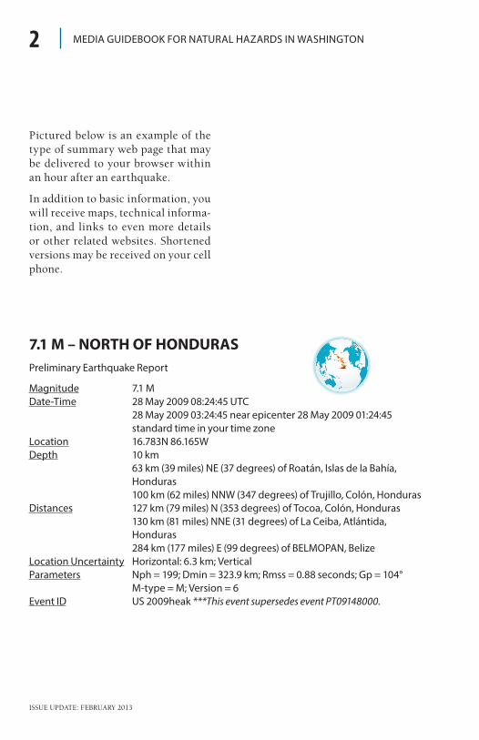
Pictured below is an example of the type of summary web page that may be delivered to your browser within an hour after an earthquake
In addition to basic information, you will receive maps, technical informa-tion, and links to even more details or other related websites Shortened versions may be received on your cell phone
2
7.1 M – NORTH OF HONDURASPreliminary Earthquake Report
Magnitude 7.1 MDate-Time 28 May 2009 08:24:45 UTC 28 May 2009 03:24:45 near epicenter 28 May 2009 01:24:45
standard time in your time zoneLocation 16.783N 86.165WDepth 10 km 63 km (39 miles) NE (37 degrees) of Roatán, Islas de la Bahía,
Honduras 100 km (62 miles) NNW (347 degrees) of Trujillo, Colón, HondurasDistances 127 km (79 miles) N (353 degrees) of Tocoa, Colón, Honduras 130 km (81 miles) NNE (31 degrees) of La Ceiba, Atlántida,
Honduras 284 km (177 miles) E (99 degrees) of BELMOPAN, BelizeLocation Uncertainty Horizontal: 6.3 km; VerticalParameters Nph = 199; Dmin = 323.9 km; Rmss = 0.88 seconds; Gp = 104°
M-type = M; Version = 6Event ID US 2009heak ***This event supersedes event PT09148000.
ISSUE UPDATE: FEBRUARY 2013
Earthquake Maps
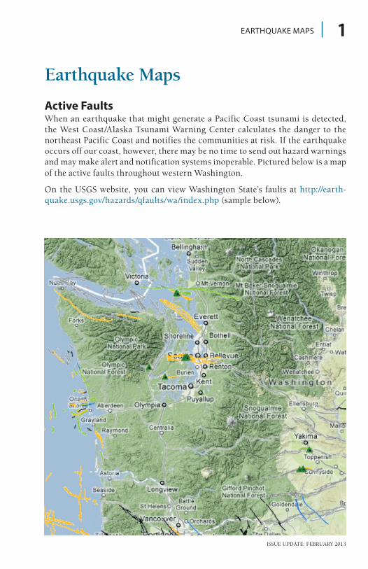
Active Faults When an earthquake that might generate a Pacific Coast tsunami is detected, the West Coast/Alaska Tsunami Warning Center calculates the danger to the northeast Pacific Coast and notifies the communities at risk If the earthquake occurs off our coast, however, there may be no time to send out hazard warnings and may make alert and notification systems inoperable Pictured below is a map of the active faults throughout western Washington
On the USGS website, you can view Washington State’s faults at http://earth-quake usgs gov/hazards/qfaults/wa/index php (sample below)
1EARTHQUAKE MAPS

ISSUE UPDATE: FEBRUARY 2013
MEDIA GUIDEBOOK FOR NATURAL HAZARDS IN WASHINGTON2
Seismic Hazard MapSeismic Hazard Maps show areas of seismic hazard that account for all earth-quakes that may impact the mapped area The hazard is conveyed in terms of the strength of shaking expected during some specified number of years Downloadable archived maps can be found on the USGS website at http://earth-quake usgs gov/hazards/products/conterminous/2008/maps/
ISSUE UPDATE: FEBRUARY 2013
EARTHQUAKE MAPS 3
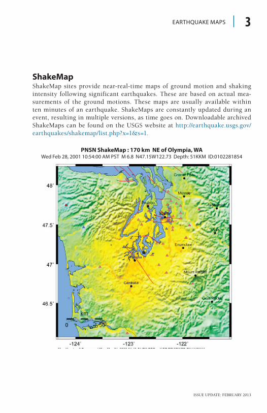
ShakeMapShakeMap sites provide near-real-time maps of ground motion and shaking intensity following significant earthquakes These are based on actual mea-surements of the ground motions These maps are usually available within ten minutes of an earthquake ShakeMaps are constantly updated during an event, resulting in multiple versions, as time goes on Downloadable archived ShakeMaps can be found on the USGS website at http://earthquake usgs gov/earthquakes/shakemap/list php?x=1&s=1
PNSN ShakeMap : 170 km NE of Olympia, WAWed Feb 28, 2001 10:54:00 AM PST M 6.8 N47.15W122.73 Depth: 51KKM ID:0102281854

ISSUE UPDATE: FEBRUARY 2013
MEDIA GUIDEBOOK FOR NATURAL HAZARDS IN WASHINGTON
Did You Feel It?People who experience an earthquake can go online and share information about its effects to help create a map of shaking intensities Such maps contribute greatly toward the quick assessment of the scope of an earthquake’s impacts and provide valuable data for earthquake research Just like Shakemaps, Did You Feel it? maps are continuously updated as an event progresses Downloadable Did You Feel It? maps can be found on the USGS website at http://earthquake usgs gov/earthquakes/dyfi/archives php?query=&search_archives=Search+Archives
4
USGS Community Internet Intensity MapNisqually
Wed Feb 28, 2001 10:54:00 AM PST M 6.8 N47.15W122.73 Depth: 51KKM ID:0102281854
ISSUE UPDATE: FEBRUARY 2013
MEASURING EARTHQUAKES 5
Measuring Earthquakes
Magnitude describes the size of earthquake based on amplitudes of the seismic waves it radiates Intensity measures the impacts of an earthquake at a particular site, which depends on the magnitude and also on the distance from the earthquake and other factors Magnitude and intensity measure different proper-ties; magnitude describes the size of the earthquake and intensity describes its impacts at a particular location
MagnitudeMagnitude is related to the amount of energy released by the earthquake source It is usually determined by measuring the amplitude of the earthquake waves recorded by a seis-mograph, with corrections applied to account for the energy lost as the waves travel to the seismograph’s location Magnitude should therefore be independent of where the mea-surements are made Different types of magnitudes may be estimated and reported because the types of waves measured or methods used may differ
‘Richter’ magnitude refers to a method used for smaller earthquakes
recorded locally, and the most com-monly reported type now is the ‘moment’ magnitude While magni-tudes are designed to agree with one another sometimes they may differ by a few tenths or more This does not mean either one is incorrect, but just reflects the imprecision of the estimates
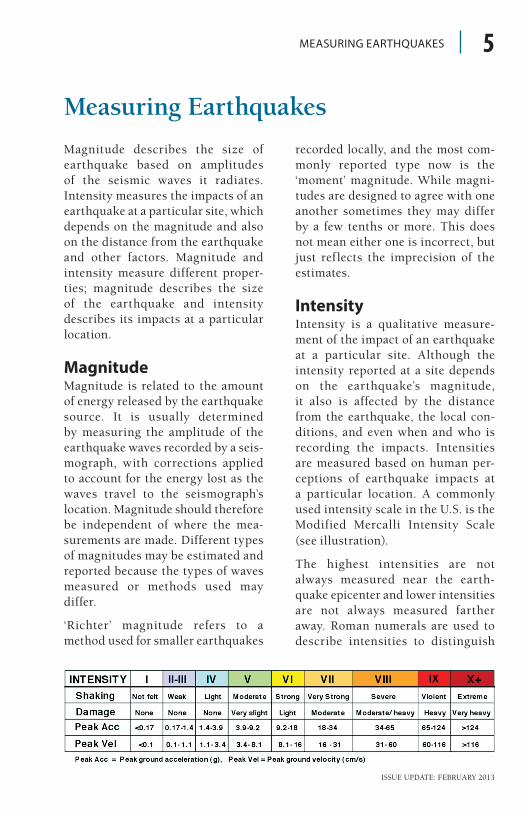
IntensityIntensity is a qualitative measure-ment of the impact of an earthquake at a particular site Although the intensity reported at a site depends on the earthquake’s magnitude, it also is affected by the distance from the earthquake, the local con-ditions, and even when and who is recording the impacts Intensities are measured based on human per-ceptions of earthquake impacts at a particular location A commonly used intensity scale in the U S is the Modified Mercalli Intensity Scale (see illustration)
The highest intensities are not always measured near the earth-quake epicenter and lower intensities are not always measured farther away Roman numerals are used to describe intensities to distinguish

ISSUE UPDATE: FEBRUARY 2013
MEDIA GUIDEBOOK FOR NATURAL HAZARDS IN WASHINGTON
them from magnitudes Empirical relationships between intensity val-ues and various shaking levels and the amount of damage experienced at the measurement site have been derived
ShakeMap and Did You Feel It? maps use these relationships to convey instrumentally measured shaking levels in terms of their likely impacts
6
ISSUE UPDATE: FEBRUARY 2013
Source Affected Area Max. Size Recurrence
Subduction Zone W. WA, OR, CA M 9 500-600 yr
Deep Juan de Fuca plate W. WA, OR M 7+ 30-50 yr
Crustal faults WA, OR, CA M 7+ Hundreds of years
EARTHQUAKE FACT SHEET 1
Earthquake Fact Sheet
What is an epicenter?The epicenter is the point on the earth’s surface vertically above the point where an earthquake rupture begins The area of rupture does not occur just at a single point, but over a vast area along the fault for a large earthquake
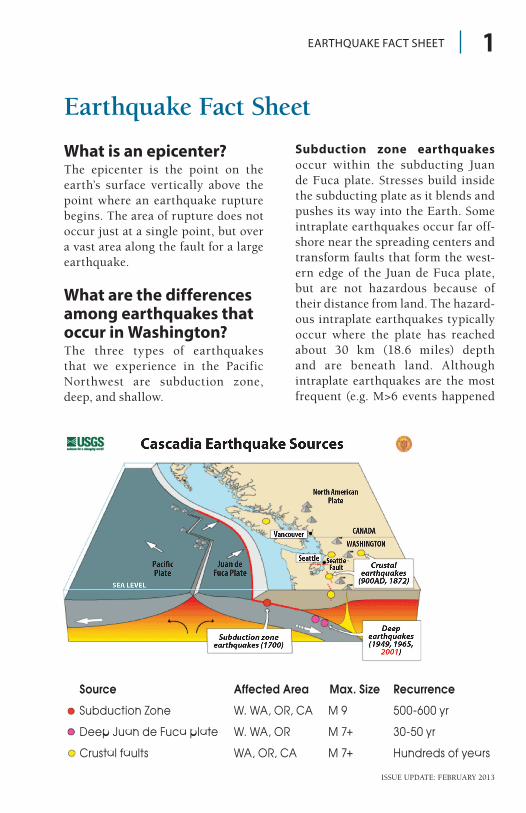
What are the differences among earthquakes that occur in Washington? The three types of earthquakes that we experience in the Pacific Northwest are subduction zone, deep, and shallow
Subduction zone earthquakes occur within the subducting Juan de Fuca plate Stresses build inside the subducting plate as it blends and pushes its way into the Earth Some intraplate earthquakes occur far off-shore near the spreading centers and transform faults that form the west-ern edge of the Juan de Fuca plate, but are not hazardous because of their distance from land The hazard-ous intraplate earthquakes typically occur where the plate has reached about 30 km (18 6 miles) depth and are beneath land Although intraplate earthquakes are the most frequent (e g M>6 events happened
ISSUE UPDATE: FEBRUARY 2013
MEDIA GUIDEBOOK FOR NATURAL HAZARDS IN WASHINGTON
in Puget Sound in 1949, 1965, and 2001), they tend to be less damaging because their depth make them far-ther away The largest deep intraplate earthquakes likely would not exceed M~7 They also tend to have few or no aftershocks
Deep earthquakes result from friction and other forces along the uppermost section of the inter-face between the subducting and overriding plates impede subduc-tion This ‘locked zone’ of the plate interface is a giant fault, capable of producing giant earthquakes often called ‘megathrusts’ (the overriding plate thrusts over the subducting plate) The plates continuously move toward one another at a rate of about 4 centimeters/year (1 6 inches/year), building stresses along the locked portion of the plate interface Over hundreds of years enough stress has built that the locked interface breaks The meters of relative motion across the fault that should have occurred while it was locked take place within just hundreds of seconds, releasing all the stresses and radiating seismic waves In Cascadia the last megath-rust was in 1700, and megathrusts recur every 500 years on average in the northern half of the region, and possibly more often in the southern half
2
Shallow earthquakes occur within the crust of the North American plate The relative motion affecting the North American plate squeezes it in a north-south direction at a rate of about 4 millimeters/year ( 16 inches/year), so damaging earthquakes on any particular fault recur at intervals of thousands to tens of thousands of years Because there are lots of crustal faults located just beneath the surface, the hazard is significant but localized near the fault
What are aftershocks?Aftershocks are earthquakes that follow the largest shock of an earth-quake sequence They are smaller than the main shock Aftershocks can continue over a period of weeks, months, or years In general, the larger the main shock, the larger and more numerous the aftershocks, and the longer they will continue
ISSUE UPDATE: FEBRUARY 2013
SAFETY ACTIONS 1
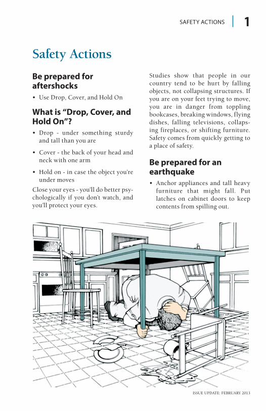
Safety Actions
Be prepared for aftershocks• Use Drop, Cover, and Hold On
What is “Drop, Cover, and Hold On”?• Drop - under something sturdy
and tall than you are
• Cover - the back of your head and neck with one arm
• Hold on - in case the object you’re under moves
Close your eyes - you’ll do better psy-chologically if you don’t watch, and you’ll protect your eyes
Studies show that people in our country tend to be hurt by falling objects, not collapsing structures If you are on your feet trying to move, you are in danger from toppling bookcases, breaking windows, flying dishes, falling televisions, collaps-ing fireplaces, or shifting furniture Safety comes from quickly getting to a place of safety
Be prepared for an earthquake• Anchor appliances and tall heavy
furniture that might fall Put latches on cabinet doors to keep contents from spilling out
ISSUE UPDATE: FEBRUARY 2013
MEDIA GUIDEBOOK FOR NATURAL HAZARDS IN WASHINGTON
• Find out how you can improve your home to protect it against earthquake damage
• Establish an “out-of-area” con-tact and keep the phone numbers handy This is the person fam-ily members will call if you are separated
• Have a place at home where emer-gency supplies are kept and tell others where it is
During an earthquakeIf you are indoors:• Stay inside Move under a desk or
sturdy table and hold on to it If it moves, move with it Stay away from windows, bookcases, refrig-erators, heavy mirrors, hanging plants, and other objects that could fall Do not go outside until the shaking stops
• If you are in a crowded store or public place, do not rush for an exit Move away from display shelves holding objects that could fall on you, and “drop, cover, and hold on ”
• If you are in a theater or stadium, stay in your seat, protect your head with your arms Do not leave until the shaking stops
If you are outdoors:• If you are outdoors, move to a clear
area away from trees, signs, build-ings, or downed electrical lines
If you in a downtown area:• If you are on a sidewalk near a
tall building, get into a building’s doorway or lobby to protect your-self from falling brick, glass, and other debris
If you are driving:• If you are driving, slowly pull over
to the side of the road and stop Avoid overpasses, power lines, and other hazards Stay inside the vehicle until the shaking stops
If you are in a wheelchair:• If you are in a wheelchair, stay in
it Move to safe cover if possible, lock your wheels and protect your head with your arms
After an earthquake• If you were evacuated, wait until
you are told it is safe before return-ing home
• Be careful entering buildings Stay away from downed power lines
• Check yourself and those around you for injuries
• Be ready for aftershocks
• Do not use the phone Call 9-1-1 only if it’s an emergency
• Do not drive unnecessarily
• If you smell gas or hear a hissing sound - open a window and leave the building Shut off the main gas valve outside
2
ISSUE UPDATE: FEBRUARY 2013
• Check on neighbors, particularly elderly or disabled persons
• Try to contact your out-of-area phone contact
• Listen to your radio
• Do not rush to school to pick up kids
Utility safetyElectricityElectricity sparks have the potential of igniting natural gas if it is leak-ing It is wise to teach all responsible household members where and how to shut off the electricity
• Locate your electricity circuit box
• Teach all responsible household members how to shut off the elec-tricity to the entire house
• FOR YOUR SAFETY: Always shut off all the individual circuits before shutting off the main cir-cuit breaker
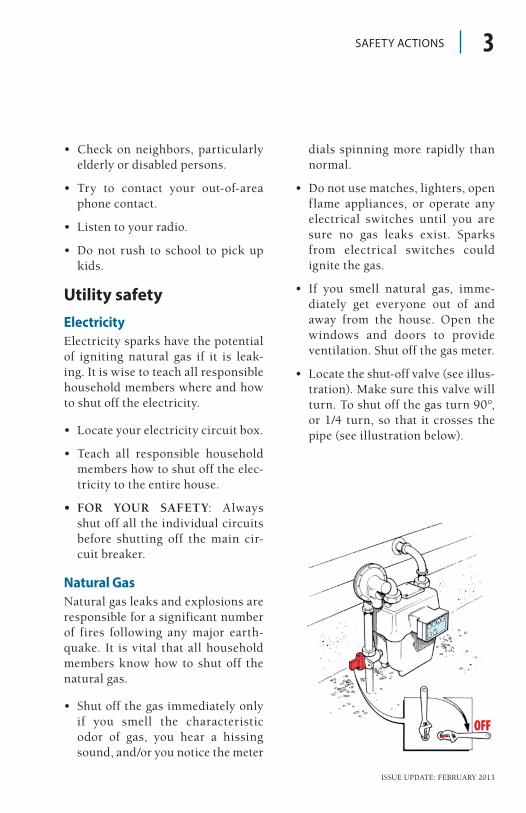
Natural GasNatural gas leaks and explosions are responsible for a significant number of fires following any major earth-quake It is vital that all household members know how to shut off the natural gas
• Shut off the gas immediately only if you smell the characteristic odor of gas, you hear a hissing sound, and/or you notice the meter
dials spinning more rapidly than normal
• Do not use matches, lighters, open flame appliances, or operate any electrical switches until you are sure no gas leaks exist Sparks from electrical switches could ignite the gas
• If you smell natural gas, imme-diately get everyone out of and away from the house Open the windows and doors to provide ventilation Shut off the gas meter
• Locate the shut-off valve (see illus-tration) Make sure this valve will turn To shut off the gas turn 90°, or 1/4 turn, so that it crosses the pipe (see illustration below)
SAFETY ACTIONS 3
ISSUE UPDATE: FEBRUARY 2013
MEDIA GUIDEBOOK FOR NATURAL HAZARDS IN WASHINGTON
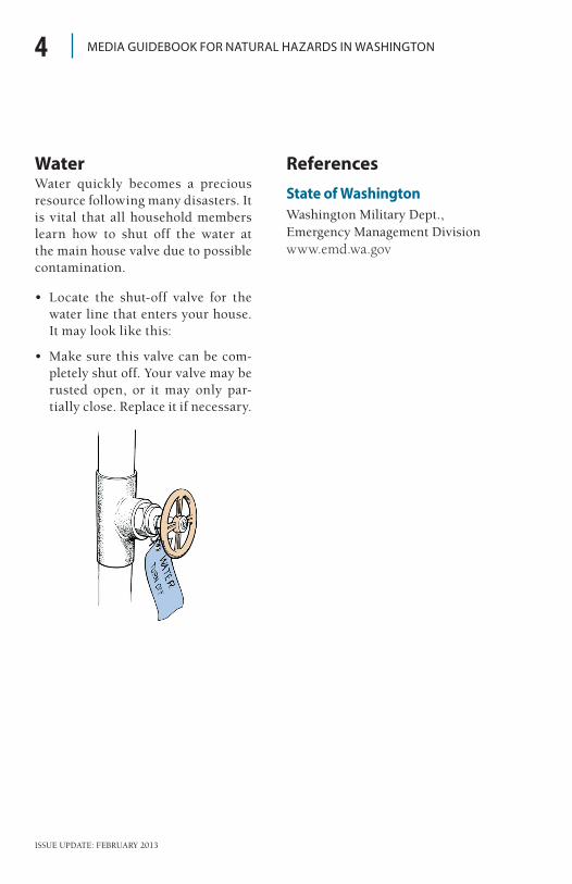
WaterWater quickly becomes a precious resource following many disasters It is vital that all household members learn how to shut off the water at the main house valve due to possible contamination
• Locate the shut-off valve for the water line that enters your house It may look like this:
• Make sure this valve can be com-pletely shut off Your valve may be rusted open, or it may only par-tially close Replace it if necessary
4
ReferencesState of WashingtonWashington Military Dept , Emergency Management Divisionwww.emd.wa.gov