investigating climate change impacts in south australia's ......o under a drying climate, yield...
TRANSCRIPT

Key findings
Low rainfall areas:
o Knowledge and experience held by successful operators is highly valuable (and worth exporting!)
o Sandy surface soils with a large plant-available waterholding capacity will be most resilient for production (while remaining a focus for wind erosion protection).
Medium rainfall areas:
o Under a drying climate, yield optimisation might be at the expense of soil cover and erosion risk
o Land managers will increasingly focus on risk management strategies to capitalise on good years and reduce losses in the bad.
High rainfall areas:
o There may be opportunities to boost or expand cropping activities in historically wet and cool regions.
Why investigate potential impacts to grain production and soil erosion risk?
In the driest State in the driest inhabited continent, climate has a major influence on agricultural production, natural environments, and how we make use of natural resources. In the decades ahead, climate scientists are predicting a warming, drying trend across southern Australia. This is a concern for SA’s dryland (rain-fed) cropping zone which is already largely limited by moisture.
Declining growing-season rainfall may bring less reliable grain production and less crop biomass to protect soils from erosion. Land managers know that soils are an important natural resource. Soils require good management to protect their productive capacity and vital ecosystem services such as storage and recycling of carbon, water and
INVESTIGATING CLIMATE CHANGE IMPACTS IN SOUTH AUSTRALIA’S CROPPING ZONE
Potential climate change impacts on wheat yields and soil erosion risk have been investigated across South Australia’s cropping zone. The study, which linked crop simulation modelling with soil and land mapping, indicates that:
• Low rainfall areas will arguably have the greatest need for land managers to adapt to a drying climate.
• In the short-term at least, adaptation responses are largely consistent with current ‘best practice’. But over the longer term, more transformational change might be needed.
• Adaptive and innovative land management, land use and business strategies will be needed to protect profits, communities and the natural resource base.
• Large or long-term investment decisions will impact on future farming generations. They should factor in the best available climate information.

nutrients. Any loss of topsoil degrades soil fertility, carbon content and waterholding capacity. Additional off-site impacts can include sedimentation of waterways and dams, reduced air and water quality and human health impacts.
In cropping areas, the risk of erosion is recognised and conservation farming practices which minimise soil disturbance and retain crop residues have been widely adopted.
Even so, the protection of agricultural soils from wind and water erosion requires adequate quantity and quality of cover. Any reduction in available crop biomass will have implications for the long-term sustainability of agricultural land and associated farm enterprises. If erosion risk increases, this also has broader implications for the health of natural resources and food security in South Australia.
Land managers play an important role in looking after our natural resources through activities such as revegetation, wildlife conservation, control of weeds and feral pests, and protecting waterways. Any adverse impacts to farm businesses will reduce the capacity of land managers to help deliver a range of important natural resource management outcomes in regional areas.
But a warming, drying trend won’t have the same impacts everywhere due to variation in rainfall and soils. Also there may be benefits associated with rising CO2 levels. With so many unknowns, there is a need for better information to help land managers, industry, community and policy groups to consider potential outcomes, and plan and prioritise responses to both threats and opportunities posed by climate change.
To examine these issues, a climate change, crop simulation and erosion risk modelling exercise was undertaken, spanning the whole of the dryland cereal cropping zone of SA. The study focussed on predicting wheat grain yields, stubble left after harvest (or ‘post-harvest biomass’) and associated erosion risk (related to changes in post-harvest biomass available to protect soils).
Why are we interested in climate change?
Good climate information represents a ‘holy grail’ for land managers dealing with climate variability. Typically this involves trying to optimise benefits and reduce risks associated with farming, finances and soil and land condition.
Climate scientists are responding to the need for better information by researching improved forecasting methods, and providing better resources1 to help understand weather and climate. This includes new ways of communicating about climate influences (e.g. ‘Climate Dogs’ animations2).
For the longer-term, land managers also need to consider potential changes to underlying climate systems. This is especially important where large or long-term investment decisions need to be made. While some aspects of future climate change will remain uncertain, the best available information should be taken into account.
Warming trends are emerging across South Australia (as summarised in figure 1). Rising average temperatures can also translate to shifts in extreme events, such as longer or more intense heatwaves.
In recent decades there has been a general trend towards decreased late autumn and winter rainfall across southern Australia (see figure 2), which includes most of the cropping zone of Southern SA. This contrasts with increased spring and summer monsoonal rainfall across the north of Australia (CSIRO & BoM 2012). Record rainfall in 2010 and 2011 fell in spring and summer in the southeast of the continent. This occurred during La Nina events which are associated with warmer than average sea surface temperatures to the north east of Australia.
Scientists try to understand the future climate through computer-based simulation models (Global Climate Models or GCMs), which strive to account for complex climate systems and future greenhouse gas emissions.
INVESTIGATING CLIMATE CHANGE IMPACTS IN SA’s CROPPING ZONE
1. Examples of this include the Bureau of Meteorology’s ‘Water and the Land’ site (http://www.bom.gov.au/watl/); ‘Australian Climate Influences’ (http://www.bom.gov.au/watl/about-weather-and-climate/australian-climate-influences.shtml); and the experimental ‘Predictive Ocean Atmosphere Model for Australia’ (POAMA, http://poama.bom.gov.au/). 2. ‘Climate dogs’ are short animated videos describing major climate influences in our region, see http://www.dpi.vic.gov.au/agriculture/farming-management/weather-climate/understanding-weather-and-climate/climatedogs
Figure 1. Time series of annual mean temperatures for South Australia expressed in °C above or below the 30 year (1961-90) average value. (Source: Bureau of Meteorology, http://www.bom.gov.au/cgi-bin/climate/change/timeseries.cgi)

Knowledge of these is improving with time. A likely range of future climate conditions has been assessed, based on thirteen GCMs seen to perform best across SA (Suppiah et al. 2006). They found (for areas covering SA’s cropping zone) annual average temperatures may increase by 0.4°C to 1.8°C by the year 2030, and between 0.8°C and 5.5°C by 2070. Average annual rainfall may decrease by as much as 15% by 2030 and by 45% by 2070. It should be noted that this isn’t a prediction for less rainfall every year, rather a shift in the likelihood of rainfall events, with fewer ‘above average’ years and more ‘below average’ years.
Future rainfall trends are harder to predict than temperature and CO2 trends. This is because rainfall patterns are influenced by various interacting meteorological processes operating at a range of scales, with differing importance depending on location (refer to earlier footnotes).
Changes in atmospheric circulation patterns and potential links to enhanced greenhouse warming are an area of active research. As scientists’ knowledge improves, this will lead to improved climate prediction models.
Climate scientists are concerned about the observed intensification of the ‘Sub-Tropical Ridge’ (the band of high pressure systems which traverse across southern Australia as shown in figure 3). The concern is that stronger high pressure systems are associated with decreased growing-season (April to October) rainfall (Larsen & Nicholls 2009, Timbal & Smith 2009, Timbal et al. 2010).
This is because low pressure frontal systems (or ‘cold fronts’) coming up from the Southern Ocean are an important source of growing-season rainfall in SA. However, more intense high pressure systems tend to push the cold fronts further south, or weaken any systems that are able to push northwards.
Researchers have observed that the increasing strength of the Sub-Tropical Ridge is related to rising global average temperature. The theory is that enhanced greenhouse warming increases the heat energy available at the tropics which in turn drives the large atmospheric circulation known as the ‘Hadley cell’, that descends across southern Australia. This helps explain the observed intensification of the Sub-Tropical Ridge. Research is ongoing as to how this and other climate influences may change in the future.
What was done in this study?
Modelling of wheat crops across the entire agricultural zone was achieved by linking the crop simulation model APSIM (Agricultural Production Systems Simulator) to comprehensive soil and land attribute information3 and regionally representative climate datasets spanning over 100 years. Modelling of grain yield, post-harvest biomass and erosion risk (related to soil cover levels) reflected the strong connections between production values and soil and land condition.
Analyses were based on historic climate and three alternative hypothetical (‘what if’) climate change scenarios, designed to examine the influence of declining rainfall. These scenarios considered rainfall declines of -5%, -10% and -20% compared to historic 1900-2009 data, while keeping a consistent increase in temperature (+1.5°C) and CO2 levels (from 390 to 480 parts per million). While hypothetical, these scenarios are consistent with the projected envelope of likely change by 2030 indicated by Suppiah et al. 2006.
The modelling did not account for unknown possible impacts of climate change such as significant changes in
INVESTIGATING CLIMATE CHANGE IMPACTS IN SA’s CROPPING ZONE
Highest on record Very much above record Above average Average Below average Very much below average Lowest on record
April-September Rainfall Decile Ranges
8-9 10
4-7 2-3
1
Source: Bureau of Meteorology
Figure 2. April to September (autumn and winter) rainfall deciles for 1997 to 2011. This map shows whether rainfall is above average, average or below average for the most recent 15-year period, in comparison with the entire rainfall record from 1900. Areas of highest on record and lowest on record are also shown. (CSIRO & BoM 2012)
Figure 3. The Sub-Tropical Ridge corresponds to the descending branch of a large atmospheric circulation (called the ‘Hadley cell’), driven by heat energy at the tropics (image adapted from BOM 2003).
Sub-Tropical Ridge: dry descending air produces a band of surface ‘high pressure’ systems at the middle latitudes
Circulation patterns in the atmosphere are driven by solar radiation and build-up of heat energy at the tropics
3. Mapped soil and land attribute datasets are available from the State Land & Soil Information Framework, refer to - www.environment.sa.gov.au/Knowledge_Bank/Information_data/soil-and-land

extreme events, and changes in the variability and seasonal distribution of rainfall.
Modelling crop growth across such a large area was an ambitious task, requiring some innovative thinking. Crop simulation models need to account for soil characteristics, but it would be an unmanageable task to model every different soil type used for cropping across the State. The solution was to identify key attributes by which similar soils could be grouped, and then represented by a lesser number of soil characteristic files for use in the APSIM modelling.
Therefore, all mapped soils were allocated to a ‘modelling soil profile’ group according to estimates of ‘surface soil clay content’ and ‘plant available waterholding capacity’ (PAWC), which are seen as critical parameters influencing soil-plant-water relations. Sixteen groups were established, each represented by a single custom-built APSIM soil file. Some generalisations in the APSIM soil file parameters were necessary (as each file represented a number of mapped soils) and this was consistent with the theme of a regional-scale analysis.
For analysing and presenting results spatially, the soil and land attribute datasets accounted for variable conditions (e.g. multiple soil types) found within each map unit. This allowed proportional contributions from different soils within a single map unit to be retained in the
modelling, with results presented as an area-weighted average value. When combined with the APSIM soil files, this approach took account of all soil areas used for cropping while drastically reducing the modelling effort from that normally required.
To further constrain the modelling task, a fixed rate of nitrogen (N) application was also assumed. This was set at a moderate N level, expected to provide adequate crop nutrition for all but high rainfall situations. This was consistent with our focus on assessing erosion risk (associated with rainfall limitation and poor crop biomass) when moderate levels of N would not be limiting.
Existing mapped attributes of ‘water erosion potential’ and ‘wind erosion potential’ were used as a basis to estimate benchmark levels of ‘critical cover’ required to protect different classes of land from erosion. Season by season, the simulated post-harvest biomass levels were compared against critical cover requirements. Over 100 years of modelling results were then summarised by presenting the severity (areal extent) of below critical cover at selected occurrence frequencies (e.g. 1 year in 10) to indicate potential changes in erosion risk under alternative climate scenarios. This erosion risk modelling approach was based on the maximum potential for residual crop biomass to protect soils (determined by climate) and did not account for management actions such as over-grazing, burning or cultivation. Potential changes in the frequency or severity of severe weather events were also not considered.
Simulation results for historic and climate change scenarios are presented in the form of maps and summary spatial statistics for PIRSA crop reporting districts and NRM Regions. These show simulated long-term average grain yields, post-harvest biomass and areas and frequencies of below critical cover (indicating increased erosion risk). Further details of the methods, results, modelling assumptions and limitations are presented in the summary report Liddicoat et al. 2012.
What did we find?
Growing-season rainfall and soil PAWC are recognised as key drivers of productivity. This highlights the largely rainfall limited nature of dryland cereal cropping across most of South Australia, and the important limiting effect of soil PAWC in many situations.
Results generally support field observations that some soil types outperform others across a range of climatic conditions. With other factors being equal, higher surface clay content generally corresponded to reduced yield and biomass results due to (i) greater soil moisture storage in the near surface which is prone to evaporative loss and (ii) higher ‘wilting point’ moisture levels.
INVESTIGATING CLIMATE CHANGE IMPACTS IN SA’s CROPPING ZONE

This means that drying of soils due to evaporation and water uptake by plants can often lead to plant water stress sooner on more clayey surface soils, than on sandy surface soils. This is exacerbated in drier climates, and the higher wilting point of clayey soils can be a real problem when 'filling' the soil to the level where plants can extract moisture may not regularly occur in a dry year. Shallow clayey soils were found to be most vulnerable to poor yields and low stubble cover in dry years and low rainfall areas.
In contrast, sandy surface soils combined with large PAWC (e.g. deep sands or some sandy surfaced texture -contrast soils) are found to be the most resilient for cropping in drier environments. However, despite the potential for more reliable production, sandy surface soils are typically less cohesive than clayey soils and more easily moved by wind, so will remain a focus for wind erosion risk. Inherent water erosion potential varies greatly depending on soil type, in particular the nature of texture and structure with depth. Under climate change, sound management and monitoring to minimise levels of soil disturbance will be critical for protecting soil and land condition.
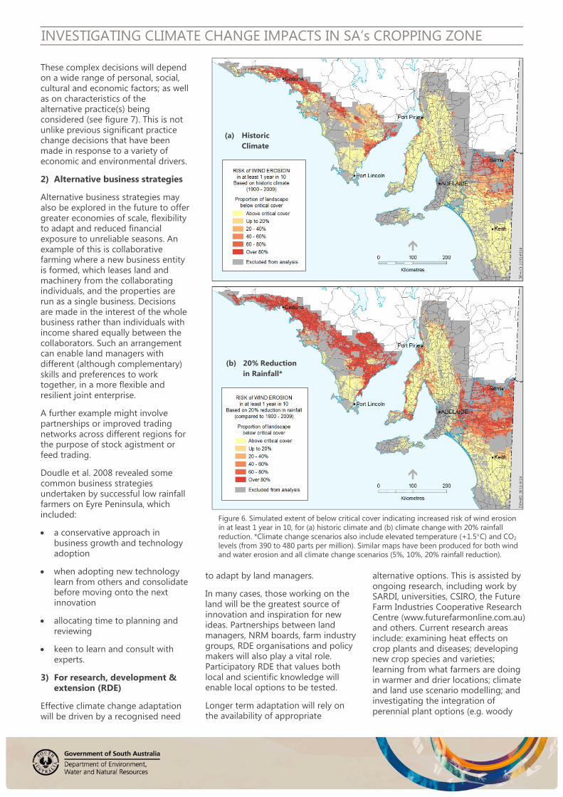
At the regional scale, simulated historic average wheat yields were comparable to observed wheat yields across SA (figure 4), providing confidence in the approach. At this scale, results from the climate change scenarios (e.g. figures 5, 6) offer further information to help plan and prioritise adaptation activities (such as identifying focus areas for extension of ‘best practice’ or participatory trialling and assessment of innovative farming, land management and business strategies) as well as providing a focus for monitoring of climate change impacts. The erosion risk maps (e.g. figure 6) highlight a patchwork of areas that land managers will need to monitor to identify any emerging and recurrent erosion risk issues.
INVESTIGATING CLIMATE CHANGE IMPACTS IN SA’s CROPPING ZONE
Low rainfall cropping environments appear most vulnerable to reducing grain yields and increasing erosion risk, under a drying climate. It is no coincidence that these areas are home to those most experienced in managing climate variability. The principles of risk management adopted by successful operators in low rainfall zones (e.g. capitalising on good years while minimising losses in bad years) will need to be further developed, and potentially exported to other regions of the State. Successful strategies will also be of value to farming communities interstate and overseas who are facing similar climate challenges.
In some medium rainfall zones, 5-10% rainfall decline may bring a trade-off between optimising grain yields at the expense of less residual biomass and hence increasing erosion risk. Meanwhile crop yield and biomass is likely to be boosted in historically wet and cool areas where rainfall is not the limiting factor and warming, drying and CO2 increase will improve crop growth. Although not specifically investigated in this study, this may give rise to new opportunities in areas that have been
historically too wet and cold for cereal cropping.
In the 20% rainfall reduction scenario, large areas of SA experience reduced grain yield and increasing erosion risk. In this scenario, total State-wide grain production (tonnage) estimates are also significantly reduced.
Additional modelling and mapping products from this study are available via the DEWNR Soil and Land Program (email: [email protected]).
What does this mean for future adaptation?
1) Land use and land management
Low rainfall areas (which experience the highest percentage drop in production) will arguably have the greatest need for land managers to adapt to a drying climate. Other areas, however, will also be impacted where declining yields impact on gross margins, particularly in high input cropping systems. Successful risk management strategies that have been developed in low rainfall, less reliable areas (e.g. Doudle et al. 2008)
Figure 4. Simulated historic average wheat grain yield results: (a) in map format; and (b) displayed as a scatterplot against PIRSA Crop Report 10-year average data (2002/03 – 2011/12), by crop reporting districts.
(a)
(b)

INVESTIGATING CLIMATE CHANGE IMPACTS IN SA’s CROPPING ZONE
may need to be taken up across wider areas of the cropping zone.
In the short-term at least, adaptation responses are largely consistent with current ‘best practice’, ‘no-regrets’ options in cropping/ grazing systems, which can include:
• strategies to improve water use efficiency (maximising the use of available water)
• risk management strategies which seek to optimise benefits and minimise losses
• consideration of soil and land types in management decisions (e.g. farming to land capability, including inherent production potential and risk [see table 1]; assessing required stubble cover and quality; grazing management)
• adopting principles of erosion protection (ie. retain or increase surface cover, minimise soil disturbance, slow the velocity of wind or run-off)
• precision farming techniques for multiple benefits (e.g. farming to land capability at sub-paddock scales; production efficiencies through variable rate input and reduced overlap; controlled traffic to reduce soil compaction and loss of PAWC)
• monitoring and adapting to land management issues (e.g. soil acidification, weeds, pests, diseases).
In general terms, conservation farming practices (no-till and stubble retention) align well with objectives to protect soils and reduce evaporative moisture loss.
Over the longer term, if incremental changes to farming systems do not keep up with climate change, it is possible that more transformational change will be needed. More complex decisions to adopt significantly different land use or land management practices are likely to be made over a number of years, perhaps over generational timeframes.
(a) 5% Reduction in Rainfall*
(b) 10% Reduction in Rainfall*
(c) 20% Reduction in Rainfall*
Figure 5. Percentage change in simulated average wheat grain yields (t/ha) compared to historic scenario. *Climate change scenarios also include elevated temperature (+1.5°C) and CO2 levels (from 390 to 480 parts per million).
These complex decisions will depend on a wide range of personal, social, cultural and economic factors; as well as on characteristics of the alternative practice(s) being considered (see figure 7). This is not unlike previous significant practice change decisions that have been made in response to a variety of economic and environmental drivers.
2) Alternative business strategies
Alternative business strategies may also be explored in the future to offer greater economies of scale, flexibility to adapt and reduced financial exposure to unreliable seasons. An example of this is collaborative farming where a new business entity is formed, which leases land and machinery from the collaborating individuals, and the properties are run as a single business. Decisions are made in the interest of the whole business rather than individuals with income shared equally between the collaborators. Such an arrangement can enable land managers with different (although complementary) skills and preferences to work together, in a more flexible and resilient joint enterprise.
A further example might involve partnerships or improved trading networks across different regions for the purpose of stock agistment or feed trading.
Doudle et al. 2008 revealed some common business strategies undertaken by successful low rainfall farmers on Eyre Peninsula, which included:
• a conservative approach in business growth and technology adoption
• when adopting new technology learn from others and consolidate before moving onto the next innovation
• allocating time to planning and reviewing
• keen to learn and consult with experts.
3) For research, development & extension (RDE)
Effective climate change adaptation will be driven by a recognised need
INVESTIGATING CLIMATE CHANGE IMPACTS IN SA’s CROPPING ZONE
(a) Historic Climate
(b) 20% Reduction in Rainfall*
Figure 6. Simulated extent of below critical cover indicating increased risk of wind erosion in at least 1 year in 10, for (a) historic climate and (b) climate change with 20% rainfall reduction. *Climate change scenarios also include elevated temperature (+1.5°C) and CO2 levels (from 390 to 480 parts per million). Similar maps have been produced for both wind and water erosion and all climate change scenarios (5%, 10%, 20% rainfall reduction).
to adapt by land managers.
In many cases, those working on the land will be the greatest source of innovation and inspiration for new ideas. Partnerships between land managers, NRM boards, farm industry groups, RDE organisations and policy makers will also play a vital role. Participatory RDE that values both local and scientific knowledge will enable local options to be tested.
Longer term adaptation will rely on the availability of appropriate
alternative options. This is assisted by ongoing research, including work by SARDI, universities, CSIRO, the Future Farm Industries Cooperative Research Centre (www.futurefarmonline.com.au) and others. Current research areas include: examining heat effects on crop plants and diseases; developing new crop species and varieties; learning from what farmers are doing in warmer and drier locations; climate and land use scenario modelling; and investigating the integration of perennial plant options (e.g. woody
Inherent Productivity High to very high Moderate Low to moderate Low Very low
Arable cropping Non arable
Inhe
rent
Ris
k
Low • Intensive cropping, high input
• Intensive cropping, high input
• Moderate to intensive cropping, low to moderate input
• Improved pasture
• Native pasture • Revegetation
Medium • Intensive cropping, high input
• Moderate to intensive cropping, moderate input
• Moderate cropping, low to moderate input
• Native pasture • Native pasture • Revegetation
High • Moderate cropping, moderate input
• Moderate cropping, moderate input
• Opportunity cropping, low input • Pasture cropping
• Fodder shrubs • Revegetation
• Native pasture • Revegetation
INVESTIGATING CLIMATE CHANGE IMPACTS IN SA’s CROPPING ZONE
High Low Level of input:
Late
Ti
min
g of
inpu
t: Ea
rly
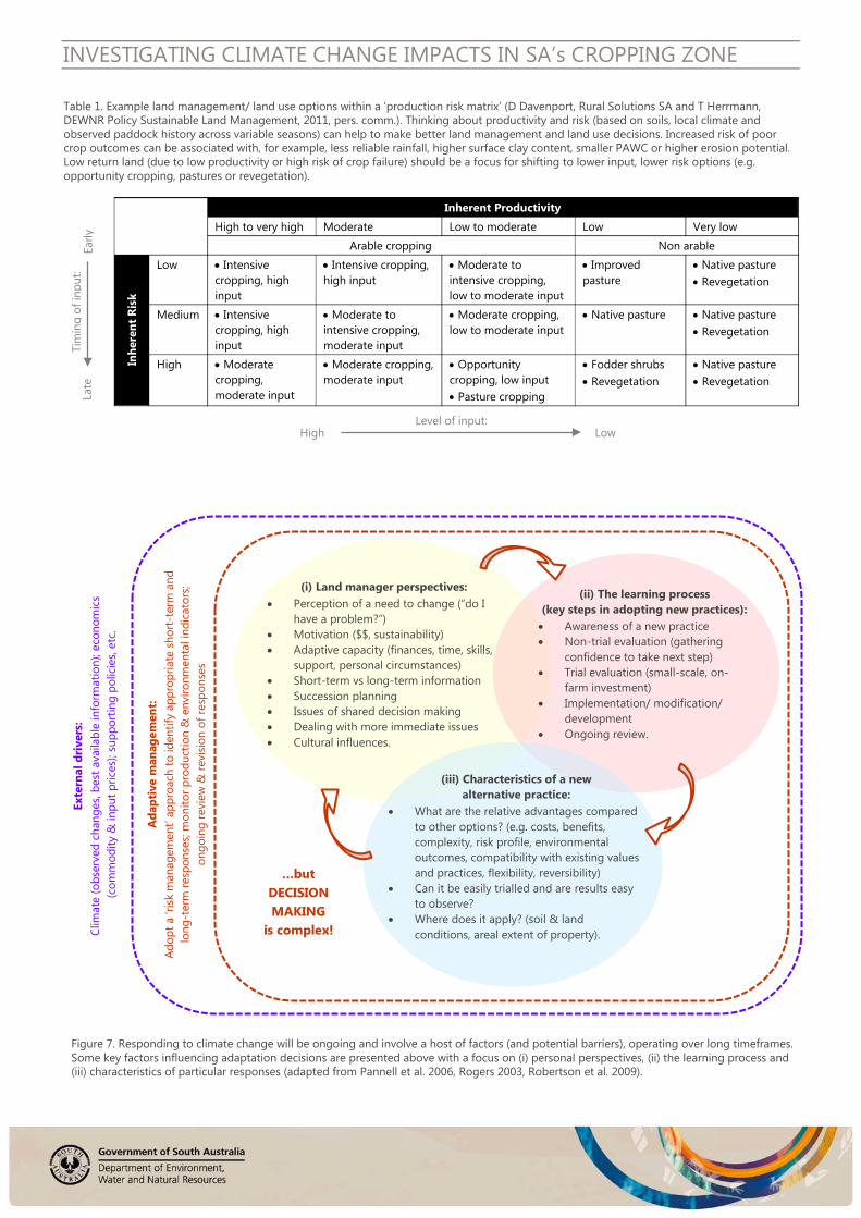
Table 1. Example land management/ land use options within a ‘production risk matrix’ (D Davenport, Rural Solutions SA and T Herrmann, DEWNR Policy Sustainable Land Management, 2011, pers. comm.). Thinking about productivity and risk (based on soils, local climate and observed paddock history across variable seasons) can help to make better land management and land use decisions. Increased risk of poor crop outcomes can be associated with, for example, less reliable rainfall, higher surface clay content, smaller PAWC or higher erosion potential. Low return land (due to low productivity or high risk of crop failure) should be a focus for shifting to lower input, lower risk options (e.g. opportunity cropping, pastures or revegetation).
Figure 7. Responding to climate change will be ongoing and involve a host of factors (and potential barriers), operating over long timeframes. Some key factors influencing adaptation decisions are presented above with a focus on (i) personal perspectives, (ii) the learning process and (iii) characteristics of particular responses (adapted from Pannell et al. 2006, Rogers 2003, Robertson et al. 2009).
Ada
ptiv
e m
anag
emen
t: Ad
opt a
‘ris
k m
anag
emen
t’ ap
proa
ch to
iden
tify
appr
opria
te s
hort
-ter
m a
nd
long
-ter
m re
spon
ses;
mon
itor p
rodu
ctio
n &
env
ironm
enta
l ind
icat
ors;
on
goin
g re
view
& re
visi
on o
f res
pons
es
…but DECISION MAKING
is complex!
Exte
rnal
dri
vers
: Cl
imat
e (o
bser
ved
chan
ges,
best
ava
ilabl
e in
form
atio
n); e
cono
mic
s (c
omm
odity
& in
put p
rices
); su
ppor
ting
polic
ies,
etc.
(i) Land manager perspectives:
• Perception of a need to change (“do I have a problem?”)
• Motivation ($$, sustainability) • Adaptive capacity (finances, time, skills,
support, personal circumstances) • Short-term vs long-term information • Succession planning • Issues of shared decision making • Dealing with more immediate issues • Cultural influences.
(ii) The learning process (key steps in adopting new practices): • Awareness of a new practice • Non-trial evaluation (gathering
confidence to take next step) • Trial evaluation (small-scale, on-
farm investment) • Implementation/ modification/
development • Ongoing review.
(iii) Characteristics of a new alternative practice:
• What are the relative advantages compared to other options? (e.g. costs, benefits, complexity, risk profile, environmental outcomes, compatibility with existing values and practices, flexibility, reversibility)
• Can it be easily trialled and are results easy to observe?
• Where does it apply? (soil & land conditions, areal extent of property).

crops, fodder species, pastures, bio-energy, essential oils).
Uncertainty over future climate can lead to varying responses in different situations (e.g. undertaking risk assessments; developing new crop varieties; monitoring trends; trialling a range of alternatives; or ‘doing nothing for now’). Flexible strategies which take early steps towards addressing climate change risks, but leave options open and do not over-commit expensive resources too early provide a valid approach to tackling uncertainty (Dobes 2008).
Some researchers advocate a focus on RDE strategies designed to deal with seasonal variability and managing immediate issues rather than anticipating future change that is beyond most planning horizons (Robertson et al. 2009). For many this may be the best approach, but there is no ‘one size fits all’. Arguably, particular RDE strategies should be established at local and regional levels, taking account of priorities for each stakeholder group.
The important role of trusted, experienced local advisors in assisting with land management decisions should also be acknowledged (Pannell et al. 2006). If big decisions are required in the future to adapt to a changing
INVESTIGATING CLIMATE CHANGE IMPACTS IN SA’s CROPPING ZONE
climate, this will be supported by local advisers with the right skills, credibility and trust of land managers to assist them through this process.
4) For policy makers
There are policy imperatives to see that:
• natural resources including soils are protected (or enhanced) over time
• sustainable land use and land management options can be put in place (coupled with viable farm business or land stewardship arrangements), in the face of environmental change
• other social, economic and environmental impacts of climate change are appropriately managed (this includes consideration of issues such as food security and the important contribution of agriculture to employment and the South Australian economy).
As such, there is a need to:
• support industry adaptation through partnerships and participatory programs relevant to local and regional needs
• ensure good access to the best available climate information to aid long-term decisions
• continue to support erosion risk monitoring for the short and long term. More focussed monitoring of elevated erosion risk areas predicted under climate change should also be considered.
• monitor the emergence of new issues that may arise.
INVESTIGATING CLIMATE CHANGE IMPACTS IN SA’s CROPPING ZONE
© State of South Australia through the Department of Environment, Water and Natural Resources 2013. Apart from fair dealings and other uses permitted by the Copyright Act 1968 (Cth), no part of this publication may be reproduced, published, communicated, transmitted, modified or commercialised without the prior written permission of the Department of Environment, Water and Natural Resources.
DISCLAIMER: While reasonable efforts have been made to ensure the accuracy of the information, including maps, contained in this publication, the Department of Environment, Water and Natural Resources makes no representations and accepts no responsibility for the accuracy, completeness or fitness for any particular purpose of the contents, and shall not be liable for any loss or damage that may be occasioned directly or indirectly through the use of or reliance on the contents of this publication.
Maps display a regional overview and should not be used to draw conclusions about specific locations. Maps are based on an interpretation of soil landscape map units which account for variable conditions found within each map unit. Boundaries between map units should be treated as transition zones. Modelling results have not been ground-truthed and should be considered preliminary.
Reference to any company, product or service in this publication should not be taken as a Departmental endorsement of the company, product or service.
ACKNOWLEDGEMENTS: The “Climate change, wheat production and erosion risk in South Australia’s cropping zone” project team comprised members from the Department of Environment, Water and Natural Resources (DEWNR), South Australian Research and Development Institute (SARDI) and Rural Solutions SA. Funding was provided by the State NRM Program in partnership with DEWNR. The project was also assisted by related SARDI project work funded by the Australian Government Department of Agriculture, Fisheries and Forestry (DAFF).
Further Information
For further information please contact:
Susan Sweeney, Senior Project Officer, Sustainable Soil & Land Management, DEWNR ([email protected])
Craig Liddicoat, Senior NRM Scientist (Soil & Land), Science Monitoring & Knowledge Branch, DEWNR ([email protected])
Peter Hayman, Principal Climate Scientist, SARDI Climate Applications ([email protected])
For the latest in climate information: Darren Ray, Senior Meteorologist & Head of South Australian Climate Section, Bureau of Meteorology ([email protected])
References BoM 2003, The greenhouse effect and climate change CSIRO & BoM 2012, State of the Climate 2012, published online: http://www.csiro.au/Outcomes/Climate/Understanding/State-of-the-Climate-2012.aspx Dobes L, 2008, Getting Real About Adapting to Climate Change: Using “Real Options” to Address the Uncertainties, Agenda, 15(3), 55-69 Doudle S, Hayman P, Wilhelm N, Alexander B, Bates A, Hunt E, Heddle B, Polkinghorne A, Lynch B, Stanley M, Frischke A, Scholz N and Mudge B. 2008. Exploring adaptive responses in dryland cropping systems to increase robustness to climate change. SARDI, Department of Climate Change Comprehensive Project Report Larsen SH & Nicholls N, 2009, Southern Australian rainfall and the subtropical ridge: Variations, interrelationships, and trends, Geophys. Res. Lett., 36, L08708, doi:10.1029/2009GL037786 Liddicoat C, Hayman P, Alexander B, Rowland J, Maschmedt D, Young M-A, Hall J, Herrmann T,Sweeney S, 2012, Climate change, wheat production and erosion risk in South Australia’s cropping zone, Department of Environment, Water & Natural Resources, Government of South Australia
Pannell DJ, Marshall GR, Barr N, Curtis A, Vanclay F, Wilkinson R, 2006, Understanding and promoting adoption of conservation
practices by rural landholders, Australian Journal of Experimental Agriculture, 46 (11), 1407-1424 Robertson M, Peek C, Grima R, Oliver Y, Weeks C, Clarke M, 2009, Evaluating options for adaptation to climate change by crop-livestock farmers in Western Australia, Paper presented at “Climate 21: Understanding climate change and how to manage it”, Burswood WA, 27 March Rogers EM, 2003, Diffusion of innovations, Fifth Edition, Free Press, New York
Suppiah R, Preston B, Whetton PH, McInnes KL, Jones RN, Macadam I, Bathols J, Kirono D, 2006, Climate change under enhanced greenhouse conditions in South Australia—an updated report on assessment of climate change, impacts and risk management strategies relevant to South Australia, CSIRO Marine and Atmospheric Research, Aspendale Victoria
Timbal B, Arblaster J, Braganza K, Fernandez E, Hendon H, Murphy B, Raupach M, Rakich C, Smith I, Whan K and Wheeler M, 2010, Understanding the anthropogenic nature of the observed rainfall decline across south-eastern Australia, Centre for Australian Weather and Climate Research, CAWCR Technical Report No. 26, 180 pp.
Timbal B & Smith I, 2009, Relationship between the Hadley Circulation and the position and intensity of the sub-tropical ridge in the Australian region, South-Eastern Australian Climate Initiative (SEACI), Final report for project 1.1.1P, 24 pp
“…a warming, drying trend won’t have the same impacts everywhere due to variation in rainfall and soils.”