investigating the climate system precipitation - nasa · investigating the climate system:...
TRANSCRIPT
Educational Product
Educators Grades 5–8
Precipitation Investigating the Climate System
Precipitation“The Irrational Inquirer”
PROBLEM-BASED CLASSROOM MODULES
Responding to National Education Standards in: English Language Arts ◆ Geography ◆ Mathematics
Science ◆ Social Studies
Investigating the Climate System
PrecipitationPrecipitation“The Irrational Inquirer”
Authored by: Mary Cerullo, Resources in Science Education, South Portland, Maine
Prepared by: Stacey Rudolph, Senior Science Prerequisite Knowledge . . . . . . . . . . . . . . . . . . . . . . . . . . . . . . . . . . . . . 3Education Specialist, Institute for
. . . . . . . . . . . . . . . . . 5(IGES), Arlington, VirginiaGlobal Environmental Strategies Additional Prerequisite Knowledge and Facts
John Theon, Former ProgramScientist for NASA TRMM Part 1: How are rainfall rates measured? . . . . . . . . . . . . . . . . . . . . . . 6Editorial Assistance, Dan Stillman,Science Communications Specialist,Institute for Global EnvironmentalStrategies (IGES), Arlington, Virginia
Graphic Design by: Susie Duckworth Graphic Design & of rainfall determined? . . . . . . . . . . . . . . . . . . . . . . . . . . . . . . . . . . . . . . 9Illustration, Falls Church, Virginia
Funded by: Activity One; Activity Two. . . . . . . . . . . . . . . . . . . . . . . . . . . . . . . . 9
NASA TRMM Grant #NAG5-9641
Give us your feedback: To provide feedback on the modules Activity One; Activity Two . . . . . . . . . . . . . . . . . . . . . . . . . . . . . . 10
educational_product Unit Extensions . . . . . . . . . . . . . . . . . . . . . . . . . . . . . . . . . . . . . . . . . . . . 11and click on “Investigating theClimate System.” Appendix A: Bibliography/Resources . . . . . . . . . . . . . . . . . . . . . . . . 12
NOTE: This module was developed as part of the series “Investigating the Climate System.”The series includes five modules:
developed under one series title, they Appendix E: TRMM Introduction/Instruments . . . . . . . . . . . . . . . . 19were designed so that each module could
. . . . . . . . . . . . . . . . . . . . . . . . . . . 21downloaded at:be used independently. They can be freely Appendix F: Florida Weather Page
Clouds, Energy, Precipitation, Weather,and Winds. While these materials were
Appendix D: Problem-Based Learning . . . . . . . . . . . . . . . . . . . . . . . 17
http://www.strategies.org/CLASS.html Appendix G: Cloud Diagram . . . . . . . . . . . . . . . . . . . . . . . . . . . . . . . . 22June 2003
CONTENTS
Grade Levels; Time Required; Objectives;Disciplines Encompassed; Key Terms; Key Concepts . . . . . . . . . . . . 2
Suggested Reading/Resources . . . . . . . . . . . . . . . . . . . . . . . . . . . . . . . 5
Truth Revealed after 200 Years of Secrecy! Pre-Activity; Activity One; Activity Two;Activity Three; Extensions. . . . . . . . . . . . . . . . . . . . . . . . . . . . . . . . 8
Part 2: How is the intensity and distribution
Airplane Pilot or Movie Critic?
Part 3: How can you study rain? . . . . . . . . . . . . . . . . . . . . . . . . . . . . . 10Foreseeing the Future of Satellites!
online, go to:https://ehb2.gsfc.nasa.gov/edcats/
Activity Three; Extensions . . . . . . . . . . . . . . . . . . . . . . . . . . . . . . 11
Appendix B: Assessment Rubrics & Answer Keys. . . . . . . . . . . . . . 13
Appendix C: National Education Standards. . . . . . . . . . . . . . . . . . . 15
Appendix H: Glossary . . . . . . . . . . . . . . . . . . . . . . . . . . . . . . . . . . . . . . 23
1 Investigating the Climate System: PRECIPITATION
Investigating the Climate System
PrecipitationPrecipitation“The Irrational Inquirer”
GRADE LEVELS Grades 5–8
TIME REQUIRED Ten to twelve 45-minute class periods
OBJECTIVES ● Students will analyze data and interpret information
in order to make predictions.
● Students will utilize satellite data to determine the intensity and distribution of rainfall.
● Students will apply satellite data to improve the safety of air travel.
● Students will analyze and research global rainfall patterns.
● Students will apply various scientific methods in order to collect and interpret precipitation measurements.
● Students will apply various scientific methods in order to predict precipitation events.
● Students will examine long-range weather predictions and compare them to archival satellite data.
● Students will study scientific data to determine how rainfall intensity and temperatures change vertically as well as horizontally.
● Students will investigate the effectiveness of using the traditional scientific method in meteorological research.
● Students will use their knowledge of TRMM to propose new instruments and satellite missions, which will aid us in understanding and predicting changes in the Earth’s climate.
● Students will present their ideas to the class.
DISCIPLINES ENCOMPASSED Meteorology, climatology, geography, language arts, mathematics (data analysis, graphing skills), and atmospheric science
KEY TERMS active sensor bright band climate
climatologycoalescecondensation nuclei/cloud nucleidew point/humiditygraupelhaillatent heatmeteorologypassive sensor/radiometerradarradiationrainfall intensity/rainfall ratescientific methodSun synchronoussupercooled watertotal integrated rainfall ratetotal ozone concentrationturbulenceweather
KEY CONCEPTS ● Clouds that produce thunderstorms, and therefore
heavy rain and hail, are called cumulonimbus. These clouds often span an extremely large temperature range. In strong thunderstorms, where the updrafts exceed 10 m/s, raindrops can actually be lofted up above the freezing level (where the temperature is lower than 0°C). Some of these drops freeze to produce ice particles, while others remain in liquid form despite the below-freezing temperatures— these are called supercooled water droplets. The combination of liquid and ice above the freezing level is known as the “mixed-phase layer.” In this region of the cloud, the ice particles and liquid water drops are colliding with each other. As a liquid drop collides with an ice particle, the liquid attaches, or accretes, to the ice, enlarging the size of the ice particle. Eventually, the ice particle with accreted liquid water (known as graupel) falls out of the updraft either because the updraft is weakening in that part of the cloud or the particle becomes too heavy. In some instances where the updraft in the cloud is tilted with height, the particle can actually fall back into the main part of the
2 Investigating the Climate System: PRECIPITATION
updraft lower down in the cloud. The particle may then be swept back up into the mixed-phase region, and grow again by accretion. If this process occurs a number of times, the graupel grows to become what we call hail.
● As the snow crystals in cumulonimbus clouds fall and get close to the 0°C region, they stick together and become large collections, or aggregates, of snow crystals. Subsequently, as they continue to fall, they start to melt so that a ring of liquid water forms around the aggregate. Because liquid water reflects much more energy back to the radar compared to ice, and because it only takes a small coating of liquid water for the aggregate to look like a raindrop to the radar, the radar senses that it is seeing really big drops. This is what produces the radar bright band (melting aggregates of snow flakes). As the particles continue to fall below the bright band, the large aggregate eventually melts into a large raindrop which, because of aerodynamic drag, eventually breaks up into smaller drops—which reduces the amount of power returned to the radar. The bright band layer shows up clearly on TRMM radar images.
● An advantage of TRMM over other satellites is its ability to use radar to penetrate through clouds, providing scientists with the three-dimensional structure of the rain formation. This is important since it is the distribution of latent heat within clouds that affects the large-scale circulations of the atmosphere. Recall that latent heat is released when water changes phase: vapor to liquid and liquid to solid. Depending on the strength of the updraft and other properties of the surrounding atmosphere, different clouds may release latent heat at different heights in the atmosphere. Forecast models need this information on the distribution of latent heat (inferred from radar structure) to accurately predict weather.
PREREQUISITE KNOWLEDGE PART 1 How satellites observe weather and other phenomena from space
According to Dr. John Theon, initiator and former program scientist for the TRMM satellite,“There are atlases of average monthly, seasonal, and annual rainfall over much of the Earth (except in the frozen regions of the planet) measured by (satellites’) passive sensors.
Because it is necessary to make assumptions about the size, density, and shape of the particles, as well as the amount of emission coming from only the clouds, these sensors provide a very indirect measure of precipitation. Also, passive sensors can infer only the total accumulated depth of precipitation in the cloud, not its vertical structure. The unique aspect of the TRMM satellite is that it utilizes passive instruments as well as active instruments which can see the full vertical structure of precipitation in the cloud, thus providing more accurate rainfall measurement.
“There are many other climatically important measurements obtained from satellites, such as the vertical temperature structure of the atmosphere, sea surface temperature and wind, total ozone concentration, ocean productivity, and land biomass. These data are available from NASA and NOAA (National Oceanic & Atmospheric Administration).
“The TRMM orbit limits its measurements to latitudes between 35°N and 35°S. TRMM does not acquire observations at higher latitudes. There are no other direct measurements of rainfall from satellites as accurate as TRMM. There are several military satellites with passive sensors that observe every place on Earth two times each day, but because they are in Sun synchronous orbits, they measure rain at the same local time at each place each day, a poor way to observe rain. Since rainfall occurs in highly variable patterns, observations at each place should be made at various times throughout the day, as is done by TRMM. Also, passive sensors measure only the total integrated rainfall rate, but radars (like those on TRMM) can measure the vertical profile of rain, which is important for understanding where the rain is forming, whether it is reaching the ground, and its effects on the stability and circulation of the atmosphere.”
How passive sensors (microwave radiometers) and active sensors (radars) work
A passive sensor (a radiometer) simply receives and measures the energy emitted by its target objects (raindrops, in this case); TRMM radiometers are also sensitive to the energy emitted by the ocean/land surface, water vapor in the atmosphere, and scattering by ice particles. An active sensor (a radar, in the case of TRMM) transmits energy and measures how much of that energy is reflected back from the target objects. Any object whose temperature is greater than absolute zero emits energy.
3 Investigating the Climate System: PRECIPITATION
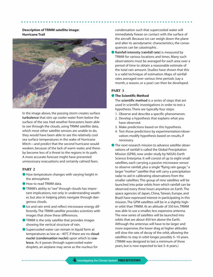
Description of TRMM satellite image: Hurricane Trail
In the image above, the passing storm creates surface turbulence that stirs up cooler water from below the surface of the sea. Had weather forecasters been able to see through the clouds, using TRMM satellite data, which most other satellite sensors are unable to do, they would have been able to see the relatively cool sea surface temperatures in the wake of Hurricane Mitch—and predict that the second hurricane would weaken, because of the lack of warm water, and thereby become less of a threat to the regions in its path. A more accurate forecast might have prevented unnecessary evacuations and certainly calmed fears.
PART 2 ● How temperature changes with varying height in
the atmosphere.
● How to read TRMM data.
● TRMM’s ability to “see” through clouds has important implications, not only in understanding weather, but also in helping pilots navigate through dangerous clouds.
● Ice and rain emit and reflect microwave energy differently. The TRMM satellite provides scientists with images that show these differences.
● TRMM is the only satellite that provides images showing the vertical structure of rain.
● Supercooled water can remain in liquid form at temperatures as low as –40°C if there are no cloud nuclei (condensation nuclei) upon which to coalesce. As it passes through supercooled water droplets, an airplane may serve as the nucleus for
condensation such that supercooled water will immediately freeze on contact with the surface of the aircraft. Because ice can weigh down the plane and alter its aerodynamic characteristics, the consequences can be catastrophic .
● Rainfall intensity (rainfall rate) is measured by TRMM for various locations and times. Many such observations must be averaged for each area over a period of time to obtain a reasonable estimate of the total rain amount. Studies have shown that this is a valid technique of estimation. Maps of rainfall rates averaged over various time periods (say a month, a season, or a year) can then be developed.
PART 3 ● The Scientific Method
The scientific method is a series of steps that are used in scientific investigations in order to test a hypothesis. There are typically four steps: 1. Observe and describe a specific phenomenon. 2. Develop a hypothesis that explains what you
have observed. 3. Make predictions based on this hypothesis. 4. Test those predictions by experimentation/obser-
vation; modify hypothesis based on results, if necessary.
● The next research mission to advance satellite observations of rainfall is called the Global Precipitation Mission (GPM), now under study by NASA’s Earth Science Enterprise. It will consist of up to eight small satellites, each carrying a passive microwave sensor to observe rainfall, plus a single “flying rain gauge,” a larger “mother” satellite that will carry a precipitation radar to aid in calibrating observations from the smaller satellites. This group of nine satellites will be launched into polar orbits from which rainfall can be observed every three hours anywhere on Earth. The space agencies of Japan, China, Taiwan, Europe, and Brazil have expressed interest in participating in this mission. The GPM satellites will be in a slightly higher orbit than TRMM. At an altitude of 350 km, TRMM was able to use a smaller, less expensive antenna. The new series of satellites will be launched into orbits that are about 450 km above the Earth. Although the antennas will have to be larger and more expensive, the lower drag at higher altitudes will slow the rate of decay of the orbit, allowing the satellites to stay in orbit longer, possibly 5–10 years. (TRMM was designed to last a minimum of three years, but is now expected to last 5–6 years.)
4 Investigating the Climate System: PRECIPITATION
ADDITIONAL PREREQUISITE KNOWLEDGE AND FACTS ● Chart reading skills
● Understanding of mean, median, and mode
● Water cycle
● Supercooled water droplets remain liquid from 0°C to as low as –40°C if there are no cloud nuclei upon which to freeze.
● Map reading skills
● The first record of rain measurements occurred in India in 350 B.C.
● The first use of rain gauges occurred in 1247 in China. (See “Major Milestones in the History of Precipitation Research” on page 11 of A Global Eye on Tropical Rainfall Measuring Mission [TRMM] for more rainfall measurement facts.)
● Every year, The Old Farmer’s Almanac makes a general weather forecast for the United States as a whole, as well as 16 regional weather forecasts. It predicts weather information for each month. For example, in 1998 it predicted: “Texas, January 1999: Temperature 47° (2° above average); precipitation 0.5” (1” below average). 1–9 Sunny, mild. 10–20 Sunny, cool. 21–31 Snow north, rain central, warm south.” There is no scientific basis for such predictions other than historical records which have skill only in the gross climatic sense.
● For the teacher—Activity One: Scientific Method (p.10)—The purpose of this activity is for students to think about the scientific method and how it applies to studying real-world Earth systems. The traditional application of the scientific method, involving experiments in controlled environments, is not possible in this type of research. There are no independent/dependent variables and there is no way to repeat an experiment to test conclusions.
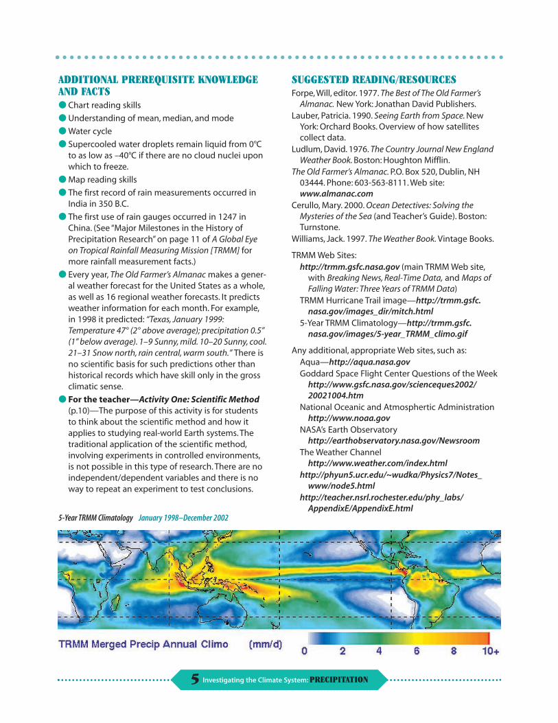
5-Year TRMM Climatology January 1998–December 2002
SUGGESTED READING/RESOURCES Forpe, Will, editor. 1977. The Best of The Old Farmer’s
Almanac. New York: Jonathan David Publishers. Lauber, Patricia. 1990. Seeing Earth from Space. New
York: Orchard Books. Overview of how satellites collect data.
Ludlum, David. 1976. The Country Journal New England Weather Book. Boston: Houghton Mifflin.
The Old Farmer’s Almanac. P.O. Box 520, Dublin, NH 03444. Phone: 603-563-8111. Web site: www.almanac.com
Cerullo, Mary. 2000. Ocean Detectives: Solving the Mysteries of the Sea (and Teacher’s Guide). Boston: Turnstone.
Williams, Jack. 1997. The Weather Book. Vintage Books.
TRMM Web Sites: http://trmm.gsfc.nasa.gov (main TRMM Web site,
with Breaking News, Real-Time Data, and Maps of Falling Water: Three Years of TRMM Data)
TRMM Hurricane Trail image—http://trmm.gsfc.nasa.gov/images_dir/mitch.html
5-Year TRMM Climatology—http://trmm.gsfc.nasa.gov/images/5-year_TRMM_climo.gif
Any additional, appropriate Web sites, such as: Aqua—http://aqua.nasa.gov Goddard Space Flight Center Questions of the Week
http://www.gsfc.nasa.gov/scienceques2002/ 20021004.htm
National Oceanic and Atmosphertic Administration http://www.noaa.gov
NASA’s Earth Observatory http://earthobservatory.nasa.gov/Newsroom
The Weather Channel http://www.weather.com/index.html
http://phyun5.ucr.edu/~wudka/Physics7/Notes_ www/node5.html
http://teacher.nsrl.rochester.edu/phy_labs/ AppendixE/AppendixE.html
5 Investigating the Climate System: PRECIPITATION
PART 1
How are rainfall rates measured?
● How have we traditionally collected rainfall (and other weather) data?
● How has that data been used to make forecasts?
MATERIALS Street map of the local community
2–3 sheets of clear acetate that will cover the map
Computers with Internet connection
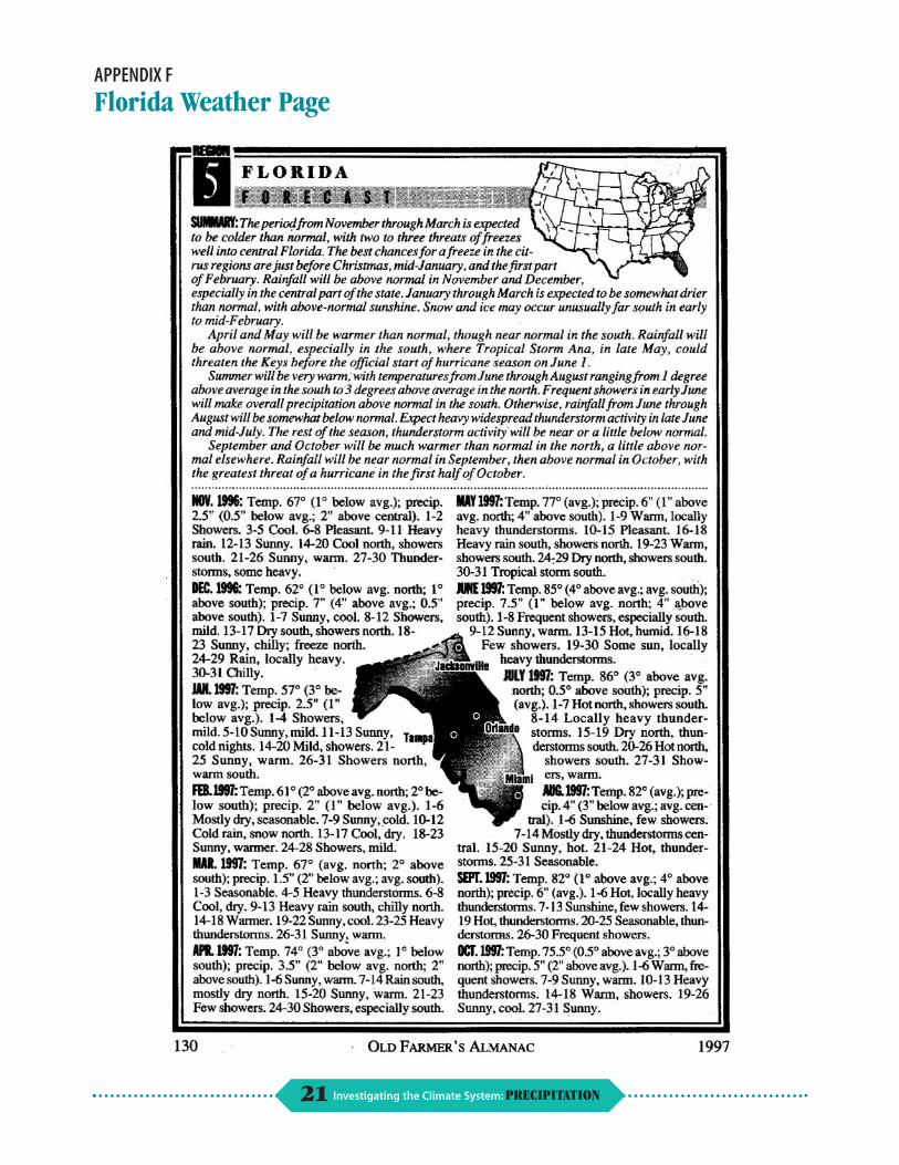
Samples of The Old Farmer’s Almanac (optional, sample page provided in Appendix E), Florida, 1997
Reference books on weather
Truth Revealed After 200 Years of Secrecy!
SETTING THE STAGE
Asomewhat shady investigative reporter, Sheila Wright Jonque, is pursuing leads for an exposé to be published in the
popular supermarket tabloid, The Irrational Inquirer. Because her newspaper has been sued several times for unsubstantiated stories written by Sheila, her editor now insists that she provide supporting evidence from an independent source before he’ll agree to publish any more of her articles. Sheila has found an unlikely (and unwilling) accomplice in the state climatologist. She wants the climatologist to dig up facts for her to corroborate a breaking story, the first in a series titled “How Do They Do That: Predicting Weather,” about the reliability of the venerable The Old Farmer’s Almanac.
The Old Farmer’s Almanac has been predicting the weather since 1792. It uses past rainfall patterns and many other data in a secret formula to make forecasts up to a year and a half in advance.
Sheila wants the state climatologist to help her document how well The Almanac’s past predictions of precipitation events have correlated with actual events (in other words, how often are their predictions correct?).
To provide an introduction for her story, she first needs to describe how scientists collect
rainfall and other weather data, in the past and present. She then needs to understand how they predict rainfall. With this information, she will be able to write her article. Because Sheila’s editor is hesitant to publish an article written by her, she needs your help, as the state climatologist, to ensure the information provided in her article is accurate. How would you help Sheila grasp the basics of meteorology so she can research her story? Where would you go to get her information to compare past and present weather information?
About two weeks ago, Sheila took it upon herself to conduct an interview with Dr. John Theon, initiator and former Program Scientist for the TRMM
satellite. The following is some information she obtained from him:
Notes from an interview with Dr. John Theon on how satellites
measure weather and other phenomena from space:
“There are atlases of average monthly, seasonal, and annual rainfall over most of the Earth (except in the frozen regions of the planet) measured by (satellites’) passive sensors. These sensors do not directly measure frozen precipitation [e.g., snow], so they cannot provide truly global precipitation observations. (Although the TRMM radar cannot detect most snow, passive sensors are sensitive to the scattering from ice particles). There are average monthly, seasonal, and annual global surface temperature observations made by satellite sensors. There are also average cloud cover observations over the entire Earth obtained from satellites.
6 Investigating the Climate System: PRECIPITATION
Part 1: How are rainfall rates measured?
“There are many other climatically important measurements obtained from satellites, such as the vertical temperature structure of the atmosphere, sea surface temperature and wind, total ozone concentration, ocean productivity, and land biomass. These data are available from NASA and NOAA.”
“The TRMM (Tropical Rainfall Measuring Mission) orbit limits its measurements to latitudes between 35°N and 35°S. There are no other measurements of rainfall from satellites as accurate as TRMM. There are several military satellites with passive sensors that cover every place on Earth two times each day, but because they are in Sun synchronous orbits, they measure rain at the same local time at each place each day, a poor way to observe rain (since rain is notoriously chaotic in its day-to-day occurrence). TRMM is an asynchronous orbit, meaning that it observes a given place at varying times of the day each month. Also, passive sensors measure only the total integrated column rainfall rate (the sum of all rain in the atmospheric column—not just what’s hitting the ground), but radars (like those on TRMM) can measure the vertical profile of rain which is important for understanding where the rain is forming.”
“Meteorologists sometimes estimate area rainfall from ground-based radar observations (actually, the national weather service uses radar whenever possible), but the weather radars are some
times so poorly calibrated that these estimates are not very accurate. However, calibration is only a small part of the problem. There are many difficulties in using radar to estimate the actual rainfall on the ground; and this includes measurements from the TRMM PR (Precipitation Radar). Because the radar measures above the ground surface and drops can evaporate before they hit the ground, not all of the radar beam may be sampling inside of the cloud. Part may be outside, and most importantly, the distribution of raindrops varies from one location to another, as well as from one time to another. Since radars have to make assumptions about the distribution of raindrops in the clouds, which are often incorrect, the rainfall estimates are often way off compared to rain gauges. This brings up another problem—the spatial variability of rain and the sampling of a rain gauge (point measurement) vs. the large area sampled by a radar (see the next paragraph below). TRMM’s Precipitation Radar (PR), on the other hand, is the best calibrated, most stable radar in the world! In addition, PR’s viewing geometry is far superior to that of ground-based radars. By the way, radar is termed an active sensor, not a passive one.”
“Meteorologists use ground-based rain gauges, usually located at weather stations, to measure rainfall. Rain gauge measurements are not necessarily representative of rainfall amount over a general area (as inferred from
radar), since rainfall amount is highly variable from place to place, even across short distances. TRMM measures rain averaged over a whole area. Consider that a radar samples an area 105–106 times larger than that of a rain gauge; if the precipitation varies on a scale smaller than what the radar can sample, the radar estimate will be biased. On the other hand, radar does give a better picture of the area coverage of rain compared to rain gauges.”
A good math problem for the students would be to calculate how much bigger an area the radar samples, compared to that of a rain gauge. Figure that a rain gauge has an area of 0.1m and that the radar samples an area of about 1 km x 1 km.
“It is certainly true that The Old Farmer’s Almanac uses historical data to predict the coming year’s weather. This will be a good forecast if the weather follows previous averages. However, there is little forecast information in historical averages if the weather is not typical. Weather is a very noisy variable, meaning that averages do not describe it well except in general terms. Yes, in general, it is colder in winter than in summer, and yes, The Almanac sometimes forecasts a storm accurately well in advance, but this is more by chance than by skill. Even the best scientific forecasts for more than a week or 10 days in advance have only a 10 percent skill, and the best forecasters will tell you that.”
7 Investigating the Climate System: PRECIPITATION
Part 1: How are rainfall rates measured?
PRE-ACTIVITY ● Determine how you would make a rain gauge.
Collect the materials, make the gauge, set it up in your backyard, and write down your measurements in a log. Be sure to include the date and time of each observation.
● After each member of the class marks the location of his or her home on a street map of the community, cover it with clear acetate and make a map of rainfall amounts. What is the most effective way to show the information on the map? Look for differences in the amounts of rainfall. Can you think of any factors related to environment or landscape that may cause variations? Discuss your findings, considering the statements made by Dr. Theon.
Activity One: How are rainfall rates measured? As the state climatologist, your job is to help Sheila with her research for her article. Sheila is unfamiliar with the topic of meteorology, so she has requested that you help her in her background investigation. She needs information on different methods of measuring rainfall. Determine what information Sheila will need to conduct her research. Where would you, as the state climatologist, go to get this information? What information would you provide to her? Remember that Sheila is required to provide supporting evidence for her article, so include resources used in the investigation.
Further Discussion Question
Besides precipitation, other instruments also measure temperature, air pressure, humidity, and wind flow. How might these help forecast rainfall/precipitation?
ActivityTwo: How are rainfall rates predicted? In writing her article, Sheila has found she needs additional information on the following topics. First determine where you would get this information. Then conduct your research and determine what information to give Sheila.
● How is data collected and used to measure precipitation? Be sure to include information on satellites and The Old Farmer’s Almanac.
● What are ground observations, weather records, and satellite observations, and what types of data do each provide?
● How can people use this information to predict rainfall?
Activity Three: Conclusion Sheila has decided that for her to determine the reliability of The Old Farmer’s Almanac, she will need to compare data from The Almanac with data collected from other resources. What kind of data would you look for? Where would you go to obtain this information?
Once you’ve obtained the appropriate data, analyze and interpret the information for Sheila. What does it mean?
Help Sheila write her article using the information you have gained. Is The Old Farmer’s Almanac accurate? Explain.
LANGUAGE ARTS EXTENSION Each student should contribute a feature to produce a class edition of The Old Farmer’s Almanac. Examine a copy and choose one section that you would write for the next issue.
MATH EXTENSION The Almanac gives the time of sunrise in Boston, Massachusetts. Use the Time Correction Tables to find the sunrise and sunset times (using Length of Day information) in your area.
STATISTICS EXTENSION Explain what the evidence indicates about the reliability of The Old Farmer’s Almanac. The state climatologist, who supplied the satellite data, warns Sheila that she really should examine more data before she writes her story. Sheila’s never used data before, so she thinks a few examples are more than enough to satisfy her editor and the newspaper’s legal department. Discuss what you would consider to be a reliable sample size and how sample size affects students’ inferences. Use an example from the class; pick some characteristic that three students have in common (such as, last names beginning with S, or blue eyes) and then extrapolate that to represent the whole class. Is that extrapolation accurate?
8 Investigating the Climate System: PRECIPITATION
PART 2
How is the intensity and distribution of rainfall determined?
MATERIALS ● Temperature and rainfall
vary at various altitudes. Line drawing of cloud diagram (reproducible for students to write on—see Appendix G); pencil and paper; Internet access
Airplane Pilot or Movie Critic?
SETTING THE STAGE
Aprivate airplane was descending slowly toward an airport when it suddenly went into a steep dive, much to the
dismay of its passengers and crew. After several minutes of terror, the pilot was able to regain control and safely land the plane.
As luck would have it, it was a private jet carrying rock star Damonna and her latest fiancé. According to friends of the rock diva, the pilot left the cockpit unattended while he joined his celebrity passengers to watch the in-flight movie, “Airplane!” However, the pilot claims that he was at the controls throughout the flight and that the plane flew through an ice storm at
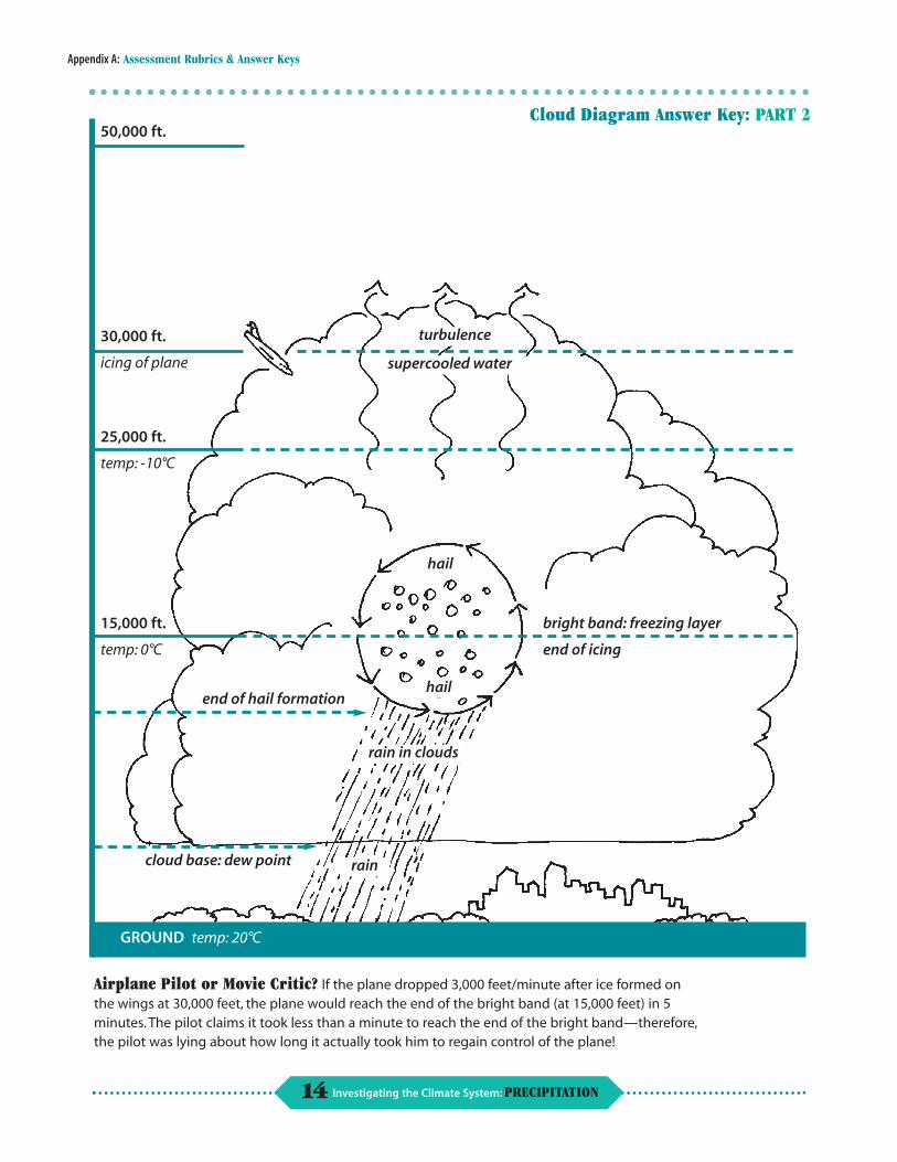
30,000 feet. The ice coated the wings, he said, making the plane so heavy that it started to fall rapidly. According to the pilot, warming temperatures at lower altitudes melted enough ice that he was able to regain control of the plane and land it safely.
Sheila Wright Jonque, investigative reporter for The Irrational Inquirer, has chosen this as the second story in her series “How Do They Do That: Predicting Weather.” In her interviews with the pilot and the passengers, she has found discrepancies in their statements. Sheila has asked the state climatologist to help her obtain data from the TRMM satellite to use in an attempt to reconstruct the entire event.
In his interview with Sheila, the pilot claims to have hit turbulence at 30,000 feet as he descended through the clouds. He states that it was at this time that they passed through an area of supercooled water causing ice to form on the wings, subsequently causing the plane to drop 3,000 feet/minute. After less than a minute, he says, the plane reached the bottom of the bright band and the ice melted, allowing him to regain control, descend at a normal rate of 1,000 feet/minute, and safely land the plane.
Can the climatologist back up the pilot’s claim by examining TRMM satellite data for that date over the region where the plane was flying?
Activity One: What are we talking about? Before conducting any more research, Sheila has realized that she doesn’t fully understand the information she has gathered. As the state climatologist, she has asked you to brief her to bring her up to speed. Put together a briefing for her, including all relevant background information that will help her reconstruct the event and write the story.
Activity Two: What happened? How do you find out if the pilot is telling the truth? Sheila has asked you to help research the information necessary to determine whether the pilot is telling the
truth. She has determined three areas she needs help in. Is her list below complete? If not, what other information does she need?
● The interior structure of clouds and how they form,
● A description of the bright band, and
● The importance of this information in flight navigation.
Once you are done with the research, make a diagram for Sheila that shows how the incident might have happened.
9 Investigating the Climate System: PRECIPITATION
PART 3
How can you study rain?
Foreseeing the Future of Satellites!
SETTING THE STAGE
For her final article in
her “How Do They
Do That: Predicting
Weather” series,
Sheila Wright Jonque, inves
tigative reporter, is trying to
determine what the next er satellites, such as the
generation of weather- TRMM satellite, and the
observing satellites might be. types of questions scientists
As the state climatologist, would like to be able to
you’ve been asked for your answer in the future.
help in understanding the
capabilities of current weath-
Activity One: The Scientific Method
a. You have worked with Sheila before and are aware that she is unfamiliar with the scientific method. Before she continues with this investigation, you would like to teach her about the scientific method, so she can use it to research, understand, and write her stories. What information do you need to provide for Sheila?
b. How applicable is this method to real-world research in meteorology?
c. Determine how meteorologists apply the scientific method to their real-world research. Are there differences between the scientific method in laboratory versus real-world conditions? Describe these differences.
Activity Two: Why do we care about rainfall?
MATERIALS
● Internet access
● Map of the world—highlight the area of TRMM coverage (provide two maps for each group of students working together)
The central question that TRMM seeks to answer is “What is the global pattern of rainfall?”
Observing and modeling the distribution of clouds and precipitation is important. Small changes in distribution can lead to big changes in climate, although we still don’t fully understand how and why. For instance, changing the average base height of clouds around the globe by 1000 feet would change the global climate.
a. Sheila has spoken with a sociologist (someone who studies human society), who believes she should include information on the impact of rainfall patterns on human population in her article. As a climatologist, you are familiar with the effects of rainfall patterns. What information do you need to provide Sheila? Why is this important for her article?
b. Working in small groups, study the two world maps depicting TRMM coverage. Look at the data presented. What information is provided? Discuss what you see, and any correlation between the data. Why did scientists choose the area of TRMM coverage that they did?
c. How does the information you have just gathered, both the effects of rainfall patterns on human population and the data presented by the TRMM maps, relate to each other?
10 Investigating the Climate System: PRECIPITATION
Part 3: How can you study rain?
Activity Three: Future Studies
a. In investigating the future of weather studies, you and Sheila are working together to determine what questions scientists will need to answer. What background information do you need to know? What questions have scientists already answered? What information would help meteorologists or climatologists make better short and long-range forecasts? What instruments would be needed to collect this data?
b. What do you think Sheila’s final article should be titled? What information would you recommend Sheila include?
SCIENCE EXTENSION It is your task to invent the next generation of weath-er-observing satellites. Working in small groups, write up a description of your satellite and what questions it will answer, so that Sheila can use the information to write her story. After the groups’ ideas have been presented, as a class, choose three frequently mentioned questions that need to be answered about rainfall and its impact on human society.
SCIENCE/ART EXTENSION Use drafting paper to draw a design of an instrument or what the next generation of weather-observing satellites might look like.
UNIT EXTENSIONS Language Arts, Fine Arts, and Foreign Language
Write up the conclusions of one of these problems using one of these styles:
●The National Inquirer: Instead of quoting the subject, write,“Friends say...”Vary the type style and point size. Write short sentences with many exclamation points.
●The Wall Street Journal: Reference scientific studies, quote authoritative experts—real or imagined— from government and business. Use big words and small type.
● A comic book: Use lots of artwork.
●Any periodical from another country, such as France or Spain. Write in the native language of that country.
Science/Geography Extension: Sheila Is Missing!
Colleagues at the newspaper have heard rumors that the editors were trying to get rid of Sheila. Perhaps, they wonder, was she abducted by a band of Amazon headhunters? They may be correct, because Sheila has not been heard from since she sent an undated report that torrential rains were assaulting the coastal region around the mouth of the Amazon River. She managed to report back that average rainfall for the month exceeded 20 inches. Examine the TRMM monthly rainfall data and find any months where the mean rainfall exceeded 20 inches at the mouth of the Amazon River. When was the last time she could have been heard from?
trmm.gsfc.nasa.gov/images_dir/avg_rainrate.html
11 Investigating the Climate System: PRECIPITATION
APPENDIX A
Bibliography/Resources
Forpe, Will, editor. 1977. The Best of The Old Farmer’s Almanac. New York: Jonathan David Publishers.
Lauber, Patricia. 1990. Seeing Earth from Space. New York: Orchard Books. Overview of how satellites collect data.
Ludlum, David. 1976. The Country Journal New England Weather Book. Boston: Houghton Mifflin.
The Old Farmer’s Almanac. P.O. Box 520, Dublin, NH 03444. Phone: 603-563-8111. Web site: www.almanac.com
Cerullo, Mary. 2000. Ocean Detectives: Solving the Mysteries of the Sea (and Teacher’s Guide). Boston: Turnstone.
Williams, Jack. 1997. The Weather Book. Vintage Books.
Web Sites:
TRMM http://trmm.gsfc.nasa.gov
Aqua http://aqua.nasa.gov
Goddard Space Flight Center Questions of the Week http://www.gsfc.nasa.gov/scienceques2002/ 20021004.htm
National Oceanic and Atmospheric Administration http://www.noaa.gov
NASA’s Earth Observatory http://earthobservatory.nasa.gov/Newsroom
The Weather Channel http://www.weather.com/index.html
Journals:
AMS Newsletter, published by the American Meterological Society
The Earth Scientist, published by the National Earth Science Teachers Association
Geotimes, published by the American Geological Institute
GSA Today, published by the Geological Society of America
Journal of Geography, published by the National Council for Geographic Education
Journal of Geoscience Education, published by the National Association of Geoscience Teachers
Nature, Macmillan Publishers
Science, published by the American Association for the Advancement of Science
Scientific American
Weatherwise, Heldref Publications
12 Investigating the Climate System: PRECIPITATION
APPENDIX B
Assessment Rubrics & Answer Keys
Rubric: PARTS 1, 2, 3
SKILL Extensively Frequently Sometimes Rarely
Demonstrates ability to access relevant information at appropriate Internet sites
Collects/organizes data
Represents findings clearly on map/graph or written/oral explanation
Participates in class discussions/ presentations
Infers links between topic under investigation and weather/climate
13 Investigating the Climate System: PRECIPITATION
Appendix A: Assessment Rubrics & Answer Keys
icing of plane
°C
°C
end of hail formation
end of icing
hail
hail
GROUND °C
30,000 ft.
50,000 ft.
25,000 ft.
temp: -10
15,000 ft.
temp: 0
turbulence
supercooled water
cloud base: dew point
bright band: freezing layer
rain in clouds
rain
temp: 20
Cloud Diagram Answer Key: PART 2
Airplane Pilot or Movie Critic? If the plane dropped 3,000 feet/minute after ice formed on the wings at 30,000 feet, the plane would reach the end of the bright band (at 15,000 feet) in 5 minutes. The pilot claims it took less than a minute to reach the end of the bright band—therefore, the pilot was lying about how long it actually took him to regain control of the plane!
14 Investigating the Climate System: PRECIPITATION
APPENDIX C
National Education Standards
SCIENCE
Content Standard: K–12
Unifying Concepts and Processes
Standard: As a result of activities in grades K–12, all students should develop understanding and abilities aligned with the following concepts and processes:
● Systems, order, and organization
● Evidence, models, and explanation
● Constancy, change, and measurement
Content Standards: 5–8
Science as Inquiry
Content Standard A: As a result of activities in grades 5–8, all students should develop:
● Abilities necessary to do scientific inquiry
● Understandings about scientific inquiry
Physical Science
Content Standard B: As a result of activities in grades 5–8, all students should develop an understanding of:
● Properties and changes in properties of matter
● Transfer of energy
Earth and Space Science
Content Standard D: As a result of activities in grades 5–8, all students should develop an understanding of:
● Structure of the Earth system
Science and Technology
Content Standard E: As a result of activities in grades 5–8, all students should develop:
● Understandings about science and technology
Science in Personal and Social Perspectives
Content Standard F: As a result of activities in grades 5–8, all students should develop an understanding of:
● Personal health
● Natural hazards
● Science and technology in society
National Research Council. 1996. National Science Education Standards p. 115, 143–171. Washington, DC: National Academy Press.
MATH
Curriculum Standards for Grades 5–8
Standard 1: Mathematics as Problem Solving
Standard 2: Mathematics as Communication
Standard 3: Mathematics as Reasoning
Standard 4: Mathematical Connections
Standard 10: Statistics
Standard 13: Measurement
National Council of Teachers of Mathematics. 1989. Curriculum and Evaluation Standards for School Mathematics p. 63–119. Reston, VA: The National Council of Teachers of Mathematics, Inc.
GEOGRAPHY
National Geography Standards for Grades 5–8
The World in Spatial Terms
Standard 1: How to use maps and other geographic representations, tools, and technologies to acquire, process, and report information from a spatial perspective.
Standard 3: How to analyze the spatial organization of people, places, and environments on Earth’s surface.
Physical Systems
Standard 7: The physical processes that shape the patterns of Earth’s surface.
Human Systems
Standard 11: The patterns and neworks of economic interdependence on Earth’s surface.
Environment and Society
Standard 15: How physical systems affect human systems.
American Geographical Society, Association of American Geographers, National Council for Geographic Education, and National Geographic Society. 1994. Geography for Life: National Geography Standards p. 143–182. Washington, DC: National Geographic Research and Exploration.
15 Investigating the Climate System: PRECIPITATION
Appendix B: National Education Standards
ENGLISH LANGUAGE ARTS
Standard 1: Students read a wide range of print and nonprint texts to build an understanding of texts, of themselves, and of the cultures of the United States and the world; to acquire new information; to respond to the needs and demands of society and the workplace; and for personal fulfillment. Among these texts are fiction and nonfiction, classic and contemporary works.
Standard 3: Students apply a wide range of strategies to comprehend, interpret, evaluate, and appreciate texts. They draw on their prior experience, their interactions with other readers and writers, their knowledge of word meaning and of other texts, their word identification strategies, and their understanding of textual features (e.g., sound-letter correspondence, sentence structure, context, graphics).
Standard 4: Students adjust their use of spoken, written, and visual language (e.g., conventions, style, vocabulary) to communicate effectively with a variety of audiences and for different purposes.
Standard 5: Students employ a wide range of strategies as they write and use different writing process elements appropriately to communicate with different audiences for a variety of purposes.
Standard 6: Students apply knowledge of language structure, language conventions (e.g., spelling and punctuation), media techniques, figurative language, and genre to create, critique, and discuss print and nonprint texts.
Standard 7: Students conduct research on issues and interests by generating ideas and questions, and by posing problems. They gather, evaluate, and synthesize data from a variety of sources (e.g., print and nonprint texts, artifacts, people) to communicate their discoveries in ways that suit their purpose and audience.
Standard 8: Students use a variety of technological and informational resources (e.g., libraries, databases, computer networks, video) to gather and synthesize information and to create and communicate knowledge.
Standard 12: Students use spoken, written, and visual language to accomplish their own purposes (e.g., for learning, enjoyment, persuasion, and the exchange of information).
National Council of Teachers of English and International Reading Association. 1996. Standards for the English Language Arts p. 24–46. Urbana, Illinois and Newark, Delaware: National Council of Teachers of English and International Reading Association.
SOCIAL STUDIES Strand 3: People, Places, and Environments. Social Studies programs should include experiences that provide for the study of people, places, and environments.
Strand 8: Science, Technology, and Society. Social Studies programs should include experiences that provide for the study of relationships among science, technology, and society.
National Council for the Social Studies. 1994. Expectations of Excellence: Curriculum Standards for the Social Studies p. 19–30. Washington, DC: National Council for the Social Studies.
16 Investigating the Climate System: PRECIPITATION
APPENDIX D
Problem-Based Learning
What is Problem-Based Learning?
The Problem-Based Learning (PBL) model of teaching is a lot like it sounds; students learn by solving a problem. While this occurs in all classrooms to a
different extent, the PBL learning model causes a drastic shift in the roles of students and teachers. In traditional teaching methods, the teacher acts as director of student learning, which is commonly passive. With PBL, these roles shift. Students become active and responsible for their own learning, and the activity is student-centered; the teacher becomes more of a facilitator or guide, monitoring student progress.
By using this model, the students gain information through a series of self-directed activities in which the students need to solve a problem. These problems drive the learning process and are designed to help students develop the skills necessary for critical thinking and problem solving. Students learn that in the real world, problems, and their solutions, are not always cut and dried, and that there may be different possible answers to the same problem. They also learn that as they continue to gain information, they need to readjust their plan. In other words, they must perform self-assessment.
A PBL lesson starts with a problem posed directly to the students. These problems are poorly structured to reflect real world situations. Students (most commonly in small, cooperative groups) are then left to determine what steps need to be taken in order to solve the problem. The teacher does not give the students the information needed prior to the activity. However, the teacher does need to make sure the students have enough prior knowledge to be able to interpret the problem and determine a plan of action.
A key component of PBL is constant feedback. While the students are constantly assessing their work, and in turn adjusting their plan, teachers also need to provide continual, immediate feedback. Without feedback, students may be uncomfortable with this type of activity, because they do not know what is expected of them. Teacher feedback provides reinforcement for student learning. Feedback should be an authentic, performance-based assessment. Students need to
continually evaluate their contributions. Rubrics provide a good guide for both teachers and students, to ensure that the students are continually kept on the right track.
Why use PBL? Traditional teaching methods focus on providing
students with information and knowledge. The PBL model also adds “real world” problem-solving skills to the classroom. It teaches students that there is sometimes more than one possible answer, and that they have to learn how to decide between/among these answers.
Students and PBL Students are broken up into groups and are pre
sented with a poorly structured, complex problem. Students should have enough background knowledge to understand the problem, but should not be experts. Any one, specific solution to the problem should not be evident. The students will need to determine what the problem is that they need to solve. Some organizational questions they may ask themselves are:
● What do we know about this problem?
● What do we need to know?
● How/where do we get the information needed to solve the problem?
The next step for the students is to determine a problem statement. From the information given to them in the problem, they should determine what they need to know and then plan a course of action to get the information they need to propose a solution. In implementing this plan, they will have to gather information to help them solve the problem. They will need to be sure that the resources they use are current, credible, accurate, and unbiased. As information is gathered and interpreted, they then apply their new knowledge, reevaluate what they know, and redetermine what they need to know to solve the problem. Once all the information is gathered, interpreted, and discussed, the group works together to propose a final solution.
17 Investigating the Climate System: PRECIPITATION
Appendix D: Problem-Based Learning
Benefits of PBL By using the Problem-Based Learning method, stu
dents gain more than just knowledge of facts. They develop critical thinking skills while working in collaborative groups to try to solve a problem. In doing this, they learn how to:
● interpret the question/problem,
● develop a problem statement,
● conduct research, reevaluating prior knowledge as new knowledge is gained,
● determine possible solutions, and
● pick the best possible solution based on the information they have gathered.
By providing immediate student feedback, the students can continually readjust their thinking, correcting any misconceptions or errors before moving on.
By using PBL, students become more familiar with “real world” problems. They learn that there is not always only one correct answer, and that they need to work together to gather enough information to determine the best solution.
The PBL Classroom When using the PBL model of instruction, it is best for students to work in small cooperative groups. The objective of this model is for students to work in a collaborative setting where they can learn social and ethical skills to determine how to answer the question presented. Students are expected to regulate themselves while in these working groups.
PBL Assessment As the student groups work together to collect information, they will need to constantly assess their own progress and readjust their plan. As they do this, they will need continual, immediate feedback from the teacher. When they become more comfortable with this model, they will learn to rely less on the teacher and become more independent. By providing the students with the grading rubric, it will serve as a guide to ensure they are on the right track throughout the activity.
18 Investigating the Climate System: PRECIPITATION
APPENDIX E
TRMM Introduction/Instruments
Introduction to the Tropical Rainfall Measuring Mission (TRMM)
Rainfall is one of the most important weather and climate variables that determine whether mankind survives, thrives, or perishes. Water is so
ubiquitous on planet Earth that we often take it for granted. Too much water results in devastating floods, and the famine caused by too little water (drought) is repsonsible for more human deaths than all other natural disasters combined. Water comprises more than 75 percent of our bodies and as much as 95 percent of some of the foods we eat.
Water is essential to life, as it nourishes our cells and removes the waste they generate. Water determines whether plants produce food, or whether they wither from drought or rot from dampness. Water is essential to our homes and factories, to our production of food, fiber, and manufactured goods, and to just about everything else we produce and consume. Although water covers more than 70 percent of the Earth’s surface, only about 3 percent is fresh water—and about 75 percent of that is inaccessible because it is locked up in glaciers and icecaps.
Another important aspect of rainfall, or any other precipitation, is its role in redistributing the energy the Earth receives from the Sun. Evaporation of water from the Earth’s surface, condensation of water vapor into cloud droplets or ice particles, snow, precipitation, runoff of the precipitation, and melting of snow and ice constitute what is known as the water cycle, or the hydrological cycle. Evaporation, the process of changing water from liquid to gas form, absorbs 540 calories of energy per gram of water; while simply raising the temperature of a gram of water one degree Celsius— without changing its phase— requires only one calorie of energy. Thus, much of the Sun’s energy that reaches the Earth’s surface is used to evaporate water instead of raising the temperature of the surface. The resulting water vapor is carried upward by the atmos
phere until it reaches a level where it is cooled to its condensation temperature. Then the water vapor releases the energy (540 calories per gram) it absorbed during the evaporation process. This “latent heat” release can occur thousands of kilometers from where the latent heat was originally absorbed.
Water plays an additional critical role in weather and climate: water vapor, it turns out, is the most abundant and most important greenhouse gas! Greenhouse gases trap some of the energy given off by the Earth’s surface in the atmosphere. Therefore, the distribution and quantity of water vapor in the atmosphere are important in determining how well the Earth can emit the energy it absorbs from the Sun back into space. Unless the Earth loses as much energy as it receives, it will warm up. If the Earth loses more energy than it receives, it will cool down. The distribution of water vapor in the atmosphere also affects cloudiness; and clouds play an important role in determining how much solar energy reaches the Earth’s surface, as well as how much heat can escape to space.
Perhaps it is now obvious that water, in all its forms, plays a critical role in determining what we call weather and climate. Our understanding of the complicated interactions involving water is insufficient to permit us to forecast, with much skill, weather beyond several days and climate beyond a few months. Because the occurrence of precipitation is highly variable in both time and space, and almost three-fourths of the Earth’s surface has no rain gauges because it is covered by the oceans, we have never been able to adequately observe the global distribution of rain. Measurements from rain gauges on islands and satellite images of clouds have led to estimates of global precipitation. But TRMM—the first satellite to measure precipitation with the accuracy available from a radar in combination with other remote sensors—represents a breakthrough in our ability to monitor precipitation on a global scale. This is already leading to improved forecasts, as shown on the next page.
19 Investigating the Climate System: PRECIPITATION
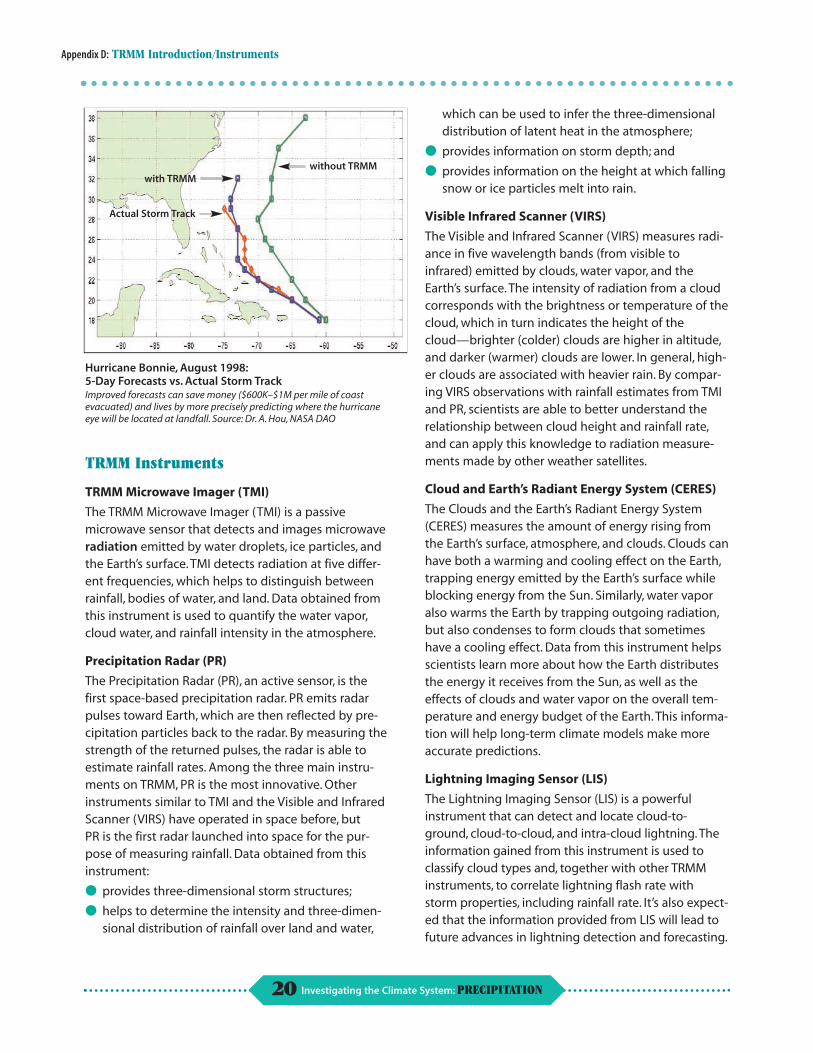
Appendix D: TRMM Introduction/Instruments
without TRMM with TRMM
Actual Storm Track
Hurricane Bonnie, August 1998: 5-Day Forecasts vs. Actual Storm Track Improved forecasts can save money ($600K–$1M per mile of coast evacuated) and lives by more precisely predicting where the hurricane eye will be located at landfall. Source: Dr. A. Hou, NASA DAO
TRMM Instruments
TRMM Microwave Imager (TMI)
The TRMM Microwave Imager (TMI) is a passive microwave sensor that detects and images microwave radiation emitted by water droplets, ice particles, and the Earth’s surface. TMI detects radiation at five different frequencies, which helps to distinguish between rainfall, bodies of water, and land. Data obtained from this instrument is used to quantify the water vapor, cloud water, and rainfall intensity in the atmosphere.
Precipitation Radar (PR)
The Precipitation Radar (PR), an active sensor, is the first space-based precipitation radar. PR emits radar pulses toward Earth, which are then reflected by precipitation particles back to the radar. By measuring the strength of the returned pulses, the radar is able to estimate rainfall rates. Among the three main instruments on TRMM, PR is the most innovative. Other instruments similar to TMI and the Visible and Infrared Scanner (VIRS) have operated in space before, but PR is the first radar launched into space for the purpose of measuring rainfall. Data obtained from this instrument:
● provides three-dimensional storm structures;
● helps to determine the intensity and three-dimen-sional distribution of rainfall over land and water,
which can be used to infer the three-dimensional distribution of latent heat in the atmosphere;
● provides information on storm depth; and
● provides information on the height at which falling snow or ice particles melt into rain.
Visible Infrared Scanner (VIRS)
The Visible and Infrared Scanner (VIRS) measures radiance in five wavelength bands (from visible to infrared) emitted by clouds, water vapor, and the Earth’s surface. The intensity of radiation from a cloud corresponds with the brightness or temperature of the cloud, which in turn indicates the height of the cloud—brighter (colder) clouds are higher in altitude, and darker (warmer) clouds are lower. In general, higher clouds are associated with heavier rain. By comparing VIRS observations with rainfall estimates from TMI and PR, scientists are able to better understand the relationship between cloud height and rainfall rate, and can apply this knowledge to radiation measurements made by other weather satellites.
Cloud and Earth’s Radiant Energy System (CERES)
The Clouds and the Earth’s Radiant Energy System (CERES) measures the amount of energy rising from the Earth’s surface, atmosphere, and clouds. Clouds can have both a warming and cooling effect on the Earth, trapping energy emitted by the Earth’s surface while blocking energy from the Sun. Similarly, water vapor also warms the Earth by trapping outgoing radiation, but also condenses to form clouds that sometimes have a cooling effect. Data from this instrument helps scientists learn more about how the Earth distributes the energy it receives from the Sun, as well as the effects of clouds and water vapor on the overall temperature and energy budget of the Earth. This information will help long-term climate models make more accurate predictions.
Lightning Imaging Sensor (LIS)
The Lightning Imaging Sensor (LIS) is a powerful instrument that can detect and locate cloud-to-ground, cloud-to-cloud, and intra-cloud lightning. The information gained from this instrument is used to classify cloud types and, together with other TRMM instruments, to correlate lightning flash rate with storm properties, including rainfall rate. It’s also expected that the information provided from LIS will lead to future advances in lightning detection and forecasting.
20 Investigating the Climate System: PRECIPITATION
APPENDIX F
Florida Weather Page
21 Investigating the Climate System: PRECIPITATION
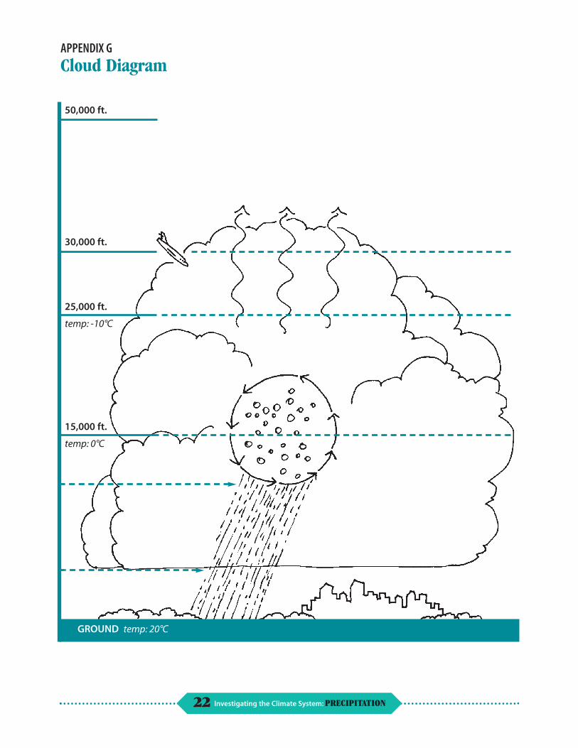
APPENDIX G
Cloud Diagram
°C
°C
GROUND °C
30,000 ft.
50,000 ft.
25,000 ft.
temp: -10
15,000 ft.
temp: 0
temp: 20
22 Investigating the Climate System: PRECIPITATION

APPENDIX H
Glossary
active sensor (active system)—A remote-sensing system (e.g., an instrument) that transmits its own radiation to detect an object or area for observation and receives the reflected or transmitted radiation. Radar is an example of an active system. 1 Compare with passive sensor.
bright band—A narrow, intense radar echo due to water-covered ice particles at the melting level where reflectivity is at its greatest. 2
climate—The average weather conditions in an area determined over a period of years. 1
climatology—Science dealing with climate and climate phenomena.1
coalesce—The merging of two water drops into a single larger drop. 2
condensation nuclei/cloud nuclei—A particle upon which water vapor condenses. It may be either in a solid or liquid state. 2
dew point—The temperature to which air must be cooled for saturation to occur, exclusive of air pressure or moisture content change. At that temperature dew begins to form, and water vapor condenses into a liquid. 1
graupel—A form of frozen precipitation consisting of snowflakes or ice crystals and supercooled water droplets frozen together. 2
hail—Precipitation composed of balls or irregular lumps of ice. Hail is produced when large frozen raindrops, or almost any particles, in cumulonimbus clouds act as embryos that grow by accumulating supercooled liquid droplets. Violent updrafts in the cloud carry the particles in freezing air, allowing the frozen core to accumulate more ice. When the piece of hail becomes too heavy to be carried by upsurging air currents it falls to the ground. 1
humidity—The amount of water vapor in the air. The higher the temperature, the greater the number of water molecules the air can hold. For example: at 60°F (15°C), a cube of air one yard (0.9 meters) on
each side can hold up to 4.48 ounces (139.3 grams) of water. At 104°F (40°C), the same cube of air can hold up to 17.9 ounces (556.7 grams) of water.
Relative humidity describes the amount of water in the air compared with how much the air can hold at the current temperature. Example: 50% relative humidity means the air holds half the water vapor that it is capable of holding; 100% relative humidity means the air holds all the water vapor it can. At 100% humidity, no more evaporation can occur until the temperature rises, or until the water vapor leaves the air through condensation. Absolute humidity is the ratio of the mass of water vapor present in a system of moist air to the volume occupied by the mixture, that is, the density of the water vapor. 1
latent heat—The amount of heat given up or absorbed when a substance changes from one state to another, such as from a liquid to a solid. 6
meteorology—The study of the atmosphere and atmospheric phenomena as well as the atmos-phere’s interaction with the Earth’s surface, oceans, and life in general. 3
passive sensor (passive system)—A system using only radiation emitted by the object being viewed, or reflected by the object, or from a source other than the system. 1 Compare with active sensor.
radar—Acronym for RAdio Detection And Ranging. An electronic instrument used to detect distant objects and measure their range by how they scatter or reflect radio energy. Precipitation and clouds are detected by measuring the strength of the electromagnetic signal reflected back. 2
radiation/radiate—The process of giving off light, heat, or other radiant energy. 4
rainfall intensity/rainfall rate—The amount of precipitation of any type, primarily liquid, per unit time. It is usually the amount that is measured by a rain gauge. 2
23 Investigating the Climate System: PRECIPITATION
Appendix H: Glossary
scientific method—The scientific method is the way scientists get from asking a question to finding an answer. The general steps involved are:
• Defining the problem
• Stating a hypothesis
• Making observations
• Collecting data
• Analyzing data, making graphs
• Drawing conclusions based on the data
• Reflecting on your conclusions and determining what you would do differently next time. 5
Sun synchronous—Describes a satellite orbit in which the satellite passes over the same place on Earth, at the same time each day. For example, a satellite’s Sun synchronous orbit might cross the equator 12 times a day, each time at 3:00 p.m. local time.
1
supercooled water—Supercooled water is water that remains in a liquid state when it is at a temperature that is well below freezing. The smaller and purer the water droplets, the more likely they can become supercooled. 2
total ozone concentration—Refers to the concentration of ozone regardless of its form (dissolved or bound) in a sample. 6
turbulence—The irregular and instantaneous motions of air, which is made up of a number of small eddies that travel in the general air current. Atmospheric turbulence is caused by random fluctuations in the wind flow. It can be caused by thermal or convective currents, differences in terrain and wind speed, a frontal zone, or variation in temperature and pressure. 2
weather—The state of the atmosphere at a specific time and with respect to its effect on life and human activities. It is the short-term variations of the atmosphere, as opposed to the long-term, or climatic, changes. It is often referred to in terms of brightness, cloudiness, humidity, precipitation, temperature, visibility, and wind. 2
1 Looking at Earth From Space Glossary of Terms NASA EP-302 2 The Weather Channel Home Page:
http://www.weather.com/glossary 3 Ahrens, C. Donald. 1994. Meteorology Today. St. Paul, MN: West
Publishing Company 4 USGS Glossary: http://interactive2.usgs.gov/glossary 5 National Center for Ecological Analysis and Synthesis:
http://www.nceas.ucsb.edu/fmt/doc?/frames.html 6 USGS Water Basics Glossary:
http://sr6capp.er.usgs.gov/GIP/h2o_gloss
24 Investigating the Climate System: PRECIPITATION