investigating urban risk accumulation in six countries in ... · investigating urban risk...
TRANSCRIPT
Investigating urban risk accumulation in six countries in Africa
Compiled by Mark Pelling
with contribution by David Satterthwaite
June 2007
An initiative supported by the United Nations Development Programme and the ProVention Consortium, in collaboration with the International Institute for Environmental Development and the University of Cape Town
Disaster Mitigation for Sustainable Livelihoods Programme
Contents
Introduction.....................................................................................................................................2
The challenges ............................................................................................................................................. 2 Urban risks.................................................................................................................................................... 3 The risk continuum ....................................................................................................................................... 3 Opportunities for risk reduction ..................................................................................................................... 3 AURAN’s work to date .................................................................................................................................. 4 Future plans.................................................................................................................................................. 5
Overview of AURAN’s work to date ................................................................................................6 Seismic vulnerability evaluation in the city of Algiers, Algeria.........................................................6
Background................................................................................................................................................... 6 Activities........................................................................................................................................................ 6 Future Priorities ............................................................................................................................................ 6
Environmental health and disaster monitoring in the Greater Accra Metropolitan Area, Ghana.....7
Background................................................................................................................................................... 7 Activities........................................................................................................................................................ 7 Future Priorities ............................................................................................................................................ 8
Action-Learning Research on Road Traffic Accidents in Kisii and Kisumu, Western Kenya...........8
Background................................................................................................................................................... 8 Activities........................................................................................................................................................ 8 Future Priorities ............................................................................................................................................ 9
Governance Surrounding the Saint Louis Flooding Problem..........................................................9
Background................................................................................................................................................... 9 Activities........................................................................................................................................................ 9 Future Priorities ...........................................................................................................................................10
Reducing risk from fires in informal settlements in Cape Town ....................................................10
Background..................................................................................................................................................10 Activities.......................................................................................................................................................10 Future Priorities ...........................................................................................................................................11
Community initiatives in managing urbanisation and risk accumulation processes: Lessons from Dar es Salaam, Tanzania.......................................................................................12
Background..................................................................................................................................................12 Activities.......................................................................................................................................................12 Future Priorities ...........................................................................................................................................13
Copyright © 2007 by the International Federation of Red Cross and Red Crescent Societies / the ProVention Consortium. Any part of this publication may be cited, copied, translated into other languages or adapted to meet local needs without prior permission from the International Federation of Red Cross and Red Crescent Societies / the ProVention Consortium, provided that the source is clearly stated. The findings, interpretations and conclusions expressed in this reports are those of the authors and do not necessarily represent the views of the International Federation of Red Cross and Red Crescent Societies. Cover photo credits: ProVention, International Federation, AURAN partners
2/13
Introduction1
By David Satterthwaite2, International Institute for Environment and Development Many disasters in Africa take place in urban areas, affecting millions of people each year. There is therefore an increasing need to understand how the risks from potential disasters develop in urban contexts, and to identify how locally owned processes can address these risks. To do this, the African Urban Risk Analysis Network (AURAN) has been formed by six African research institutions, with support from the UN Development Programme (UNDP) and ProVention. Work programmes are under way in Accra, Algiers, Cape Town, Dar es Salaam, Nairobi and Saint Louis (Senegal) to identify:
the main disaster risks and who is most vulnerable to them; the processes that lead to the accumulation of these risks, and how these are related to
environmental hazards; and what local changes can reduce these risks, particularly through actions that might be taken by
local governments, community organisations, development and disaster-oriented NGOs and other relevant agencies.
AURAN’s overall goal is to ensure that international agencies, governments and civil society develop a better understanding of disaster risks in urban areas, and the actions that are required to reduce them. The aim is both to encourage the integration of disaster risk reduction into conventional urban development planning and urban governance, and to support organisations that normally respond to disasters in expanding their role, especially in reducing the vulnerability of those people and settlements most at risk from disasters.
The challenges
AURAN has faced two challenges in getting this work going. The first is the perception among many governments and international agencies that poverty and disasters in Africa are primarily rural problems. Yet more than 350 million people in Africa live in urban centres – some two-fifths of the continent’s population. The scale of urban poverty is also much greater than is generally recognised – as can be seen by the high proportion of the urban population living below the poverty line in most nations, and high infant and child mortality rates among urban populations. In most urban centres in Africa, much of the population lives in settlements lacking the most basic infrastructure, including piped water, sanitation and drainage and all-weather roads. A significant proportion of Africa’s urban population is concentrated on coasts, and as such is particularly at risk from storms and sea-level rises.
1 This article has been reproduced with the authorisation of ODIs Humanitarian Policy Group from HPN ‘s Humanitarian
Exchange Number 35, November 2006, see www.odihpn.org/documents/humanitarianexchange035.pdf 2 David Satterthwaite is Senior Fellow, Human Settlements Group, International Institute for Environment and
Development (IIED). IIED has been working with ProVention and UNDP to support the setting up of AURAN. His email address is: [email protected].
Key characteristics of African cities African cities typically share a range of common characteristics:
A high proportion of the population lives in poor-quality and overcrowded housing in informal settlements, and many work in the informal economy.
Many informal settlements are at high risk of fire, and are located on hazardous sites (e.g. at risk from floods, landslides or earthquakes).
Risk levels are increased by a lack of infrastructure and services in many residential areas (including drainage and emergency services
governments are ineffective in taking the measures that can reduce risks Much of the population has a very limited capacity to pay for housing
3/13
The second challenge is the perception that disaster risk is best reduced by well-prepared responses to the disaster, once it occurs. In urban areas in particular, there is often huge scope for reducing disaster risk by actions and investment prior to the event. For instance, good drainage systems greatly reduce flood risk; good land-use management programmes limit the extent of urban development on land sites at high risk from landslides, earthquakes or floods. Basic investment in roads and firebreaks can greatly reduce risks from fires, especially in low-income areas where levels of risk are high because of high population densities, the use of flammable materials in house-building and the widespread use of open fires and kerosene stoves or lights. Relatively simple measures incorporated into buildings can reduce risk of collapse, in earthquake-prone areas. However, the agencies responsible for disaster response often have few contacts with the local government bodies that can take action to reduce risks like these.
Urban risks
By concentrating in one place people, enterprises and their waste – and, increasingly, motor vehicles – cities are often hazardous places in which to live and work. This is especially the case in cities where much of the low-income population settles on hazardous sites because no other land is available to them – and they also lack the means to take measures that can reduce the risks they face. Urban contexts generally increase the risk of what Allan Lavell, from the Network for the Social Study of Disaster Prevention in Latin America-LA RED, has called ‘concatenated hazards’, where a primary hazard leads to a secondary one (e.g. floods creating water-supply contamination). The many ways in which urban development can increase people’s vulnerability to disasters (i.e. the potential to be killed, injured or otherwise negatively affected) include:
Cities developing or expanding onto sites at risk from floods, landslides or earthquakes (usually particular groups, rather than the whole city, are at risk).
Cities as concentrations of activities with disaster potential – industrial accidents, transport accidents, fires or epidemics (particular groups are most at risk).
Patterns of urban form and buildings that increase scales and levels of risk from floods, landslides, earthquakes, fires, transport accidents or industrial accidents (particular groups are at risk).
The role of ‘bad’ or ‘weak’ and ‘under-resourced’ local governments in causing or exacerbating risks from floods, landslides, earthquakes, fires, transport accidents and industrial accidents.
Changes in the region around cities, which cause or exacerbate risks from floods (e.g. poor watershed management – often a particular problem for city governments as the watershed lies outside their jurisdiction).
Disaster risks from a sudden movement of people to a city (in response to war or famine, for example).
The risk continuum
When illness, injury, premature death and loss of property occur, these can be classified within a continuum from ‘everyday’ risks to ‘small’ and ‘large’ disasters, depending on the scale of the loss (and generally the frequency of the event). Disaster specialists generally focus on part of this continuum, ignoring nondisaster events (and often small disasters). This means that they do not see the links between non-disaster events and disasters, or the risk accumulation processes that are common in urban areas, and which usually increase disaster and non-disaster risks. Meanwhile, urban specialists often focus on non-disaster risk. While it is true that, in most of urban Africa, non-disaster risk contributes far more to health burdens and to poverty than disasters, this focus means that specialists miss the potential links between risk reduction for everyday hazards and small and large disasters.
Opportunities for risk reduction
Because people and enterprises are concentrated in urban areas, there are economies of scale to be had with many of the measures that reduce risks from most disasters – for instance in the per capita cost of measures to improve watershed management or drainage, reducing the scale of floods, and to respond rapidly and effectively when a disaster is imminent or happens. There is generally a greater
4/13
capacity among city-dwellers to help pay for such measures, if they are made aware of the risks and all efforts are made to keep down costs. Urban governments should be in the risk reduction business. They should have key roles as risk reducers:
They provide infrastructure and services (some perhaps is contracted to private enterprises or NGOs).
They guide where development takes place – for instance influencing where urban settlements develop and where they do not, and what provision they have to avoid floods or fires.
They regulate hazardous activities that can cause disasters (industries, transport accidents). They have an influence on land availability (land use regulations, zoning, bureaucratic procedures
for buying or obtaining land, and what can be built on it; the quality of land use management influences the proportion of poorer groups having to live on hazardous/disaster-prone sites).
They encourage/support household/community action that reduces risk (for instance better-quality housing, safer sites and good infrastructure).
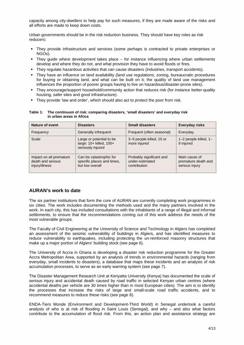
They provide ‘law and order’, which should also act to protect the poor from risk. Table 1: The continuum of risk: comparing disasters, ‘small disasters’ and everyday risk
in urban areas in Africa
AURAN’s work to date
The six partner institutions that form the core of AURAN are currently completing work programmes in six cities. The work includes documenting the methods used and the many partners involved in the work. In each city, this has included consultations with the inhabitants of a range of illegal and informal settlements, to ensure that the recommendations coming out of this work address the needs of the most vulnerable groups. The Faculty of Civil Engineering at the University of Science and Technology in Algiers has completed an assessment of the seismic vulnerability of buildings in Algiers, and has identified measures to reduce vulnerability to earthquakes, including protecting the un-reinforced masonry structures that make up a major portion of Algiers’ building stock (see page 6). The University of Accra in Ghana is developing a disaster risk reduction programme for the Greater Accra Metropolitan Area, supported by an analysis of trends in environmental hazards (ranging from everyday, small incidents to disasters), a database that maps these incidents and an analysis of risk accumulation processes, to serve as an early warning system (see page 7). The Disaster Management Research Unit at Kenyatta University (Kenya) has documented the scale of serious injury and accidental death caused by road traffic in selected Kenyan urban centres (where accidental deaths per vehicle are 30 times higher than in most European cities). The aim is to identify the processes that increase the risks of large and small-scale road traffic accidents, and to recommend measures to reduce these risks (see page 8). ENDA-Tiers Monde (Environment and Development-Third World) in Senegal undertook a careful analysis of who is at risk of flooding in Saint Louis (Senegal), and why – and also what factors contribute to the accumulation of flood risk. From this, an action plan and assistance strategy are
Nature of event Disasters Small disasters Everyday risks
Frequency Generally infrequent Frequent (often seasonal) Everyday
Scale Large or potential to be large: 10+ killed, 100+ seriously injured
3–9 people killed, 10 or more injured
1–2 people killed, 1–9 injured
Impact on all premature death and serious injury/illness
Can be catastrophic for specific places and times, but low overall
Probably significant and under-estimated contribution
Main cause of premature death and serious injury
5/13
being developed in conjunction with community groups and other stakeholders, to reduce the risk of flooding and to address communities’ vulnerability to floods (see page 9). The Disaster Mitigation for Sustainable Livelihoods Programme (DiMP) at the University of Cape Town is developing a disaster risk reduction strategy for Cape Town, with a particular interest in reducing risks from fires. This is supporting the city’s informal settlement upgrading programme. DiMP is also documenting the methods used – especially a very detailed database on the kinds and spatial locations of accidental fires – and offering advice to other institutions on how these methods might be applied in other locations (see page 10). The University College of Lands and Architectural Studies in Dar es Salaam (Tanzania) has completed the identification of disaster risks and the development of risk reduction programmes in three informal settlements in the city (see page 12). These are serving as examples of what can be done on a much larger scale.
Future plans
As the findings from the projects completed to date are disseminated, AURAN hopes to encourage many other city teams to join in this work. The findings from this work will form the basis for a large information dissemination programme, including local workshops and city-to-city exchanges. The AURAN website contains more details of current work and future plans. AURAN has already organised a major conference to report on its preliminary findings, which was held in Cape Town in early 2006. For further details, please see www.proventionconsortium.org/?pageid=32&projectid=4.
6/13
Seismic vulnerability evaluation in the city of Algiers, Algeria
By Professor Djillali Benouar, Lead Researcher, Faculty of Civil Engineering, University of Science and Technology of Bab Ezzouar, Algiers. Background
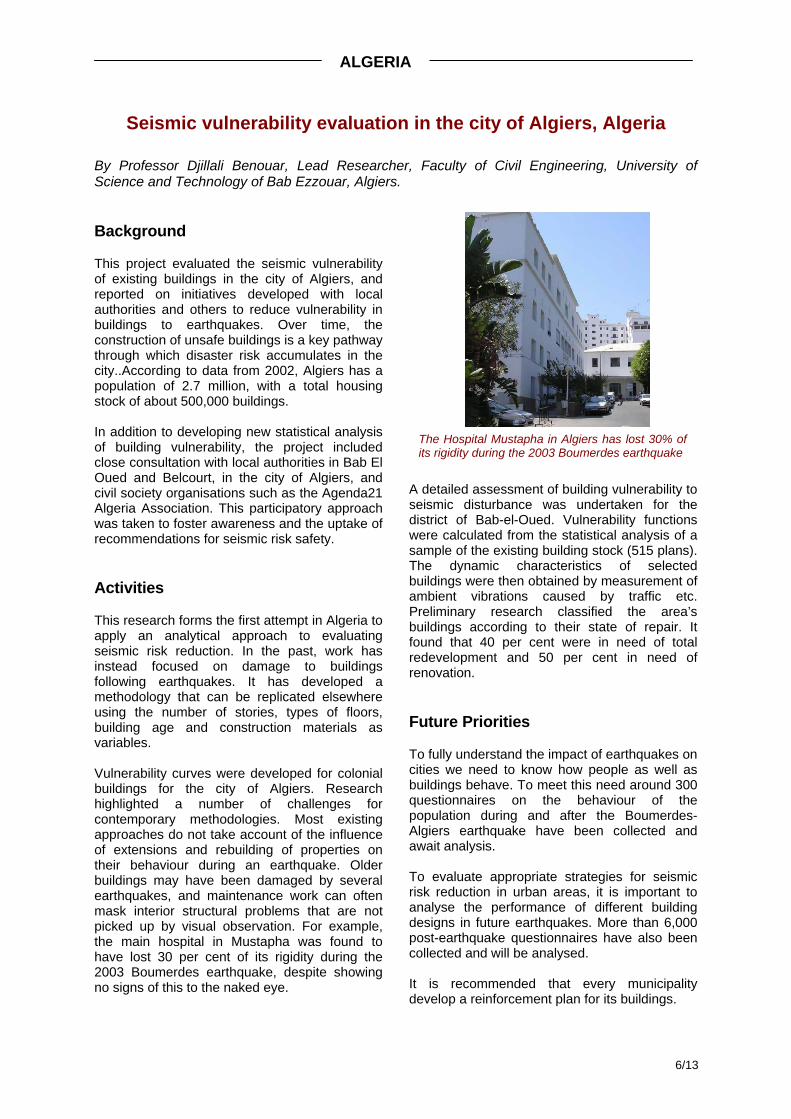
This project evaluated the seismic vulnerability of existing buildings in the city of Algiers, and reported on initiatives developed with local authorities and others to reduce vulnerability in buildings to earthquakes. Over time, the construction of unsafe buildings is a key pathway through which disaster risk accumulates in the city..According to data from 2002, Algiers has a population of 2.7 million, with a total housing stock of about 500,000 buildings. In addition to developing new statistical analysis of building vulnerability, the project included close consultation with local authorities in Bab El Oued and Belcourt, in the city of Algiers, and civil society organisations such as the Agenda21 Algeria Association. This participatory approach was taken to foster awareness and the uptake of recommendations for seismic risk safety.
Activities
This research forms the first attempt in Algeria to apply an analytical approach to evaluating seismic risk reduction. In the past, work has instead focused on damage to buildings following earthquakes. It has developed a methodology that can be replicated elsewhere using the number of stories, types of floors, building age and construction materials as variables. Vulnerability curves were developed for colonial buildings for the city of Algiers. Research highlighted a number of challenges for contemporary methodologies. Most existing approaches do not take account of the influence of extensions and rebuilding of properties on their behaviour during an earthquake. Older buildings may have been damaged by several earthquakes, and maintenance work can often mask interior structural problems that are not picked up by visual observation. For example, the main hospital in Mustapha was found to have lost 30 per cent of its rigidity during the 2003 Boumerdes earthquake, despite showing no signs of this to the naked eye.
A detailed assessment of building vulnerability to seismic disturbance was undertaken for the district of Bab-el-Oued. Vulnerability functions were calculated from the statistical analysis of a sample of the existing building stock (515 plans). The dynamic characteristics of selected buildings were then obtained by measurement of ambient vibrations caused by traffic etc. Preliminary research classified the area’s buildings according to their state of repair. It found that 40 per cent were in need of total redevelopment and 50 per cent in need of renovation.
Future Priorities
To fully understand the impact of earthquakes on cities we need to know how people as well as buildings behave. To meet this need around 300 questionnaires on the behaviour of the population during and after the Boumerdes-Algiers earthquake have been collected and await analysis. To evaluate appropriate strategies for seismic risk reduction in urban areas, it is important to analyse the performance of different building designs in future earthquakes. More than 6,000 post-earthquake questionnaires have also been collected and will be analysed. It is recommended that every municipality develop a reinforcement plan for its buildings.
ALGERIA
The Hospital Mustapha in Algiers has lost 30% of its rigidity during the 2003 Boumerdes earthquake
7/13
Environmental health and disaster monitoring in the Greater Accra Metropolitan Area, Ghana
By Jacob Songsore, Research Team Leader, University of Ghana, Legon and Team Members J.S. Nabila, Yvon Yangyuoru, Sebastian Avle, E.K. Bosque-Hamilton, Paulina E. Amponsah, Osman Alhassan, David Satterthwaite.
Background
This study brings together experiences of everyday, local and catastrophic disasters and so identifies linkages in the continuum of urban environmental risk. It builds on a 2001 analysis of household environmental problems, enabling comparison over time and between wet season (2001) and dry season (2005). Globally this is one of a very few studies that examine the influence of seasonality on urban health, important for health planning and also as a baseline for following the impact of climate change. The Greater Accra Metropolitan Area (GAMA) has a population of between 3 and 4 million. It is a low-income city in a heavily indebted poor country. The field research was supported by Environmental Health Officers and Officers of the National Disaster Management Organization.
Activities
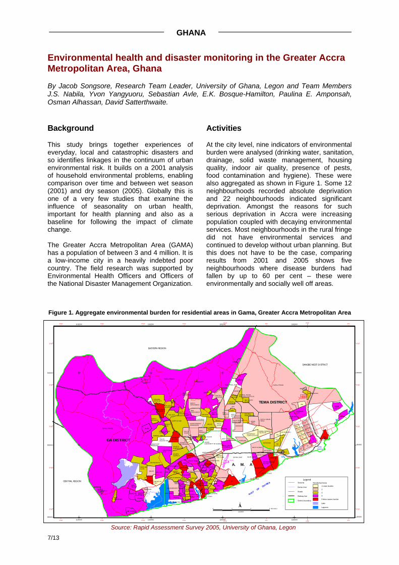
At the city level, nine indicators of environmental burden were analysed (drinking water, sanitation, drainage, solid waste management, housing quality, indoor air quality, presence of pests, food contamination and hygiene). These were also aggregated as shown in Figure 1. Some 12 neighbourhoods recorded absolute deprivation and 22 neighbourhoods indicated significant deprivation. Amongst the reasons for such serious deprivation in Accra were increasing population coupled with decaying environmental services. Most neighbourhoods in the rural fringe did not have environmental services and continued to develop without urban planning. But this does not have to be the case, comparing results from 2001 and 2005 shows five neighbourhoods where disease burdens had fallen by up to 60 per cent – these were environmentally and socially well off areas.
GHANA
Tema Harbour
LEGON (UNIVERSITY OF GHANA)
INDUSTRIAL AREA
ABLEKUMA/ABBEMAN
POLICE ACQUISITION
Airport
BURMA CAMP
LA
OSU
SALT PONDS
CANTONMENTS
OKPOI GONNO
NORTH TESHIE
DANSOMAN EST.
MPOASE
SOUTH TESANOABEKA
ALAJO
NIMA
KWASHIEMAN
NUNGUA
KORLE-BU
KANESHIE
SOUTH TESHIE
DARKUMAN
MALAM
GBEGBEYIGE
TESHIE CAMP
AIRPORT RES. AREA
SOUTH ODOKOR
BATSONAA
NORHT ODOKOR
TESHIE NUNGUA ESTATES
BUBUASHIE
EAST LEGON/SHIASHIE
KANDA
APENKWA
MINISTRIES
ABLENKPEDZORWULU
WEST RIDGE
KPEHE
NORTH KANESHIE
HEDZOLEMAN
MAMMOBI
KOTOBABI
SOUTH INDUTRAIL ARAEA
ADBRAKA
ROMAN RIDGE
KOKOM LEMLE
NAHFLADZOR
KORLE-GONNO
MAMPROBI
NEW MAMPROBI
TUDU
MATAHEKO
LARTEBIOKORSHIE
CHORKOR
SUKURA/RUSSIA
ASLYM DOW N
NORTH DZORWULU
EAST LEGON EXT.
SABON ZONGO
NEW ABOSSEY OKAI
ACCRA NEW TOWN
SOUTH LABADI
JAMES TOWN
ACCRA CENTRAL
EAST RIDGE
KORLE-DUDOR
WEST ABBOSEY OKAI
ANYWA
NORTH DOME
MADINA
GBAWE/ANYAA
MALLAM
HACHO
WEJA SEC. (1,2,3)
GBAWE
MIDIE
SOW UTUOM (1,2)
AMAMOLI (N&S)
OLUBU
SPORTS COMPLEX
AGBOGBAPOKUASE
OFANKOR (1,2,3)
DUNKUNA
APLAKU
ATOMIC ENERGY COMMISSION
REDCO
NORTH ASHONGMAN
SOUTH DOME
NEW WEIJA
OBLOGO MACARTHY HILL
POKUASE NORTH EXT.
ACHIMOTA/TRATRAHILL
PANTANG JUNCTION
AMASAMANPOKUASE
KWABENYA
BORTIANOR
OFANKOR VILLAGE
NEW ASHONGMAN
NORTH OFANKOR NARHMAN
EAST KWABENYA
WEST ADENTAN
NORTH LEGON
PAPOA
SAMPAMAN
SPORTS COMPLEX RES.
OYAREFA
WEST ASHONGMAN
PARAKUO EST.
NORTH KWABENYA
NEW BORTIANOR
OTENIB I
ABOKOBI
VANDERPUYE ORGLE EST.
NLESHIE AMANFRO EXT.
FAASE ABESE
ARMED FORCES HOUSING
ACHIMOTA/OKO
CHRISTIAN VILLAGE
KISSIEMA
BIREKUSO
POKUASE VILLAGE/AGRIC
RURAL FRINGE
SHC
C1
C2
C5
C13
C6
BATSONAA
NUGUA ANIMALFARM
C9
C16
C3
C7
OGBODZO
C20 C4
EAST ADENTA
C8
C11
C15
KPONE
AMRAHIA
C10
NGMAI JORN
ASHAIMAN EAST
C18C17
OSHIEYIE
C12
AJIRIGANO
C22
ANIMAL RESEARCH INSTITUTE
MOTORWAY NORTH ESTATE
CENTRAL ASHALEBOTWE
KPONE CENTRAL
ASHAIMAN WEST
CARA
TEMA NEW TOWN
C19 (KLAGON)
SOUTH FAFRAHA
KAKASONANKA
NEW LEGON ESTATE
ASHALEBOTWE NEW TOW N
CENTRAL ANIMAL RESEARCH INSTITUTEFAFRAHA
VILLAGE
WEST ASHALEBOTWE
GBETSILE
RGM1
SSNIT HOUSING
RURAL FRINGE
RURAL FRINGE
GA DISTRICT
TEMA DISTRICT
A. M. A
OLD DANSOMAN
1100000
1100000
1150000
1150000
1200000
1200000
1250000
1250000
300000 300000
350000 350000
400000 400000
5°30' 5°30'
5°35' 5°35'
5°40' 5°40'
5°45' 5°45'
5°50' 5°50'
0°30'
0°30'
0°25'
0°25'
0°20'
0°20'
0°15'
0°15'
0°10'
0°10'
0°5'
0°5'
0°00'
0°00'
0°5'
0°5'0
0
GULF OF
GUINEA
EASTERN REGION
CENTRAL REGION
DANGBE WEST DISTRICT
4 0 4 8 Kilometers
1:180000
N
Residential Areas
1 Least burden
2
3
4
5 Most severe burden
Lake
Lagoons
Streams
Densu river
Roads
Railway line
District boundary
Legend
Figure 1. Aggregate environmental burden for residential areas in Gama, Greater Accra Metropolitan Area
Source: Rapid Assessment Survey 2005, University of Ghana, Legon
8/13
Local and potentially catastrophic disasters in Accra are associated with flooding, earthquakes and HIV/AIDS. Local flooding is commonplace with more extensive events occurring annually. Flooding is exacerbated by rapid urbanization, improper land use practices, overflowing of riverbanks, inadequate provision of drains and haphazard development. Up to 2005, more than 200 earth tremors had been recorded in Accra. Despite this, buildings are put up haphazardly, there is no open space for any contingency, building regulations are not being enforced with few buildings constructed to withstand ground shaking. HIV/AIDS tops the Ministry of Health list of diseases for eradication, but people had little awareness of the extent of risk. City level analysis was strengthened by a detailed study of risk perceptions from Nima, a low-income community. Priority risks were found to differ by gender, occupation, and place of residence, although they tended to coincide with the ‘scientist’s’ perception of risk. Unemployment was however regarded as a risk factor in
addition to gangsterism or crime in this low-income community. Apart from floods, earthquakes and HIV/AIDS, this community included fire as another disaster risk they face.
Future Priorities
There was a lack of popular awareness on the causes of flood, earthquake risk and limited local coping was observed. Future work should prioritise raising public awareness about risk and the relationships between everyday, local and catastrophic risks and losses. This has to be complemented with the provision of adequate environmental infrastructure. Data on HIV/AIDS from varied sources do not always match. It should be a priority to undertake ongoing rigorous epidemiological work and inform the public of risk levels and options for risk reduction.
Action-Learning Research on Road Traffic Accidents in Kisii and Kisumu, Western Kenya
By Dr Andre Yitambe, Dr Isaac Mwanzo and Mr Steve Mogere. Disaster Management Research Unit, Kenyatta University, Kenya.
Background
This project examined the underlying causes of road traffic accidents (RTAs) in Kisii and Kisumu Districts, Western Kenya. In both settlements surveys were undertaken with a range of road users. An Action-Learning approach was taken where two public health officers were included in the project team. This also provided a route for gaining access to the policy community.
Activities
In Kisumu, human behaviour was identified as the predominant cause of RTAs (61%), with mechanical failures (24%) and environmental conditions (15%) also noted. Among the most important contributory factors were speeding, intoxicated or unqualified drivers, reckless driving and unsafe road use by pedestrians, cyclists and hand cart pushers. In addition, inadequate road signage, the giving of bribes to police and the poor condition of roads were noted.
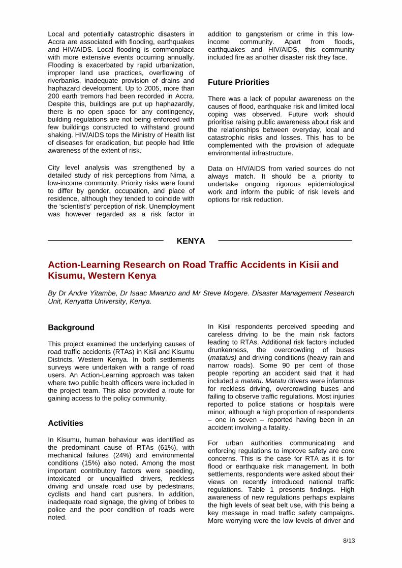
In Kisii respondents perceived speeding and careless driving to be the main risk factors leading to RTAs. Additional risk factors included drunkenness, the overcrowding of buses (matatus) and driving conditions (heavy rain and narrow roads). Some 90 per cent of those people reporting an accident said that it had included a matatu. Matatu drivers were infamous for reckless driving, overcrowding buses and failing to observe traffic regulations. Most injuries reported to police stations or hospitals were minor, although a high proportion of respondents – one in seven – reported having been in an accident involving a fatality. For urban authorities communicating and enforcing regulations to improve safety are core concerns. This is the case for RTA as it is for flood or earthquake risk management. In both settlements, respondents were asked about their views on recently introduced national traffic regulations. Table 1 presents findings. High awareness of new regulations perhaps explains the high levels of seat belt use, with this being a key message in road traffic safety campaigns. More worrying were the low levels of driver and
KENYA
9/13
pedestrian compliance with road safety signs and the high proportion of road users in both settlements viewing police enforcement of new regulations as ineffective.
Table 1: Citizen Views on RTA Risk Management in Kissi and Kisumu
Future Priorities
The project identified four areas for further work: 1. There remains great scope to foster
awareness on RTA avoidance amongst road users and law enforcers.
2. Road marking and signs are a cost effective way of managing risk – when undertaken in conjunction with road safety education and the mobilization of local communities exposed to high levels of dangerous road use.
3. Greater investment in post-accident care including first aid and tracking household livelihood impacts is required.
4. There is need for research and policy to confront the RTA vulnerability of high-risk road users including children, pedestrians and cyclists, perhaps starting with enforcing safety measures aimed at travel to and from primary school.
Governance Surrounding the Saint Louis Flooding Problem
By Khady Diagne, Lead Researcher, ENDA-Tiers Mode, Senegal. Background
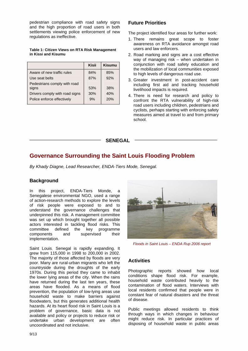
In this project, ENDA-Tiers Monde, a Senegalese environmental NGO, used a range of action-research methods to explore the levels of risk people were exposed to and to understand the governance challenges that underpinned this risk. A management committee was set up which brought together all possible actors interested in tackling flood risks. This committee defined the key programme components and supervised their implementation. Saint Louis, Senegal is rapidly expanding. It grew from 115,000 in 1998 to 200,000 in 2002. The majority of those affected by floods are very poor. Many are rural-urban migrants who left the countryside during the droughts of the early 1970s. During this period they came to inhabit the lower lying areas of the city. When the rains have returned during the last ten years, these areas have flooded. As a means of flood prevention, the population of low-lying areas use household waste to make barriers against floodwaters, but this generates additional health hazards. At its heart flood risk in Saint Louis is a problem of governance, basic data is not available and policy or projects to reduce risk or undertake urban development are often uncoordinated and not inclusive.
Activities
Photographic reports showed how local conditions shape flood risk. For example, household waste contributed heavily to the contamination of flood waters. Interviews with local residents confirmed that people were in constant fear of natural disasters and the threat of disease. Public meetings allowed residents to think through ways in which changes in behaviour might reduce risk. In particular practices of disposing of household waste in public areas
Kisii Kisumu
Aware of new traffic rules Use seat belts Pedestrians comply with road signs Drivers comply with road signs Police enforce effectively
84% 87%
53% 30% 9%
85% 92%
38% 40% 20%
Floods in Saint Louis – ENDA Rup 2006 report
SENEGAL
10/13
were challenged. This can disrupt the flow of water increasing risk from flooding and malaria. Public meetings were also held in conjunction with the Office for Public Health and the mayor. There was much discussion of the ways in which urban development and risk management strategies currently in use can serve to shift risk between places rather than necessarily reduce it. The area most at risk from flooding was identified – a neighbourhood called Pikine - as a result, residents formed a Commission of Prevention and Fight Against Floods. This project also provided a mechanism for sharing experiences between communities at risk. For example, Sanankorba village in Mali has undertaken the digging of flood channels. In this case local residents initiated the project, made bricks and provided labour with partnership from the Canadian Embassy. The lesson learned is that community solidarity plays a key role in overcoming flood risk. Meetings were also held to assess the role of Civil Defence in disaster management.
These activities have brought different interest groups and communities together to reflect on flood risk and its possible amelioration. The aim has been that through this process new information has been generated and shared and new institutional ties made that can contribute towards the building of a governance system to support risk reduction in the city.
Future Priorities
The project built on ENDA’s past work and will feed into future work on urban environmental conditions, public health and risk, and its focus on education and empowerment through governance reform. Not least through the work of a multi-stakeholder management committee. ENDA-Tiers Monde aims to further develop this initiative as an action-research project, combining research with measures aimed at behavioural change of both communities and local authorities. It has a strong interest in expanding this experience in Saint Louis to other countries in West Africa.
Reducing risk from fires in informal settlements in Cape Town
By The Disaster Mitigation for Sustainable Livelihoods Programme, at the University of Cape Town, South Africa. Background
Informal settlement fires are a risk management priority in Cape Town. In response to a lack of systematic information on informal fires, The Disaster Mitigation for Sustainable Livelihoods Programme has, since 1998, implemented focused research on the drivers of fire risk in informal settlements as well as low-income formal housing areas. This initiative intended to inform and strengthen prospective disaster risk management efforts in fire-prone informal households, communities and areas – as required both by South Africa’s disaster management legislation and the Hyogo Framework for Action. The starting point was DiMP’s pre-existing MANDISA 3 database. This is a geographical information system (GIS) based database of fire events. At the time of the AURAN project the
3 MANDISA means ‘Monitoring, mapping and Analysis
of Disaster Incidents in South Africa’
database had built a historical record from 1990-1998 including information on the location and losses attributed to all recorded fire events. The majority involved individual dwelling fires but some claimed up to 2, 000 – 3,000 dwellings in single events.
Activities
More than 19,000 incidents are now included in the MANDISA database 1990-2005. This provides an invaluable opportunity to obtain greater insight into the city’s risk profile with strategic impacts at a range of scales. Local government has been assisted in its mandated task of identifying high fire-risk settlements, including informal settlements. At the provincial level, MANDISA has contributed to a Risk Reduction and Emergency Management Sector chapter in the province’s Strategic Infrastructure Plan. Moreover, it has been referenced in the Province of the Western Cape’s strategic study on the impact of climate change. Nationally, economic loss information generated by
SOUTH AFRICA
11/13
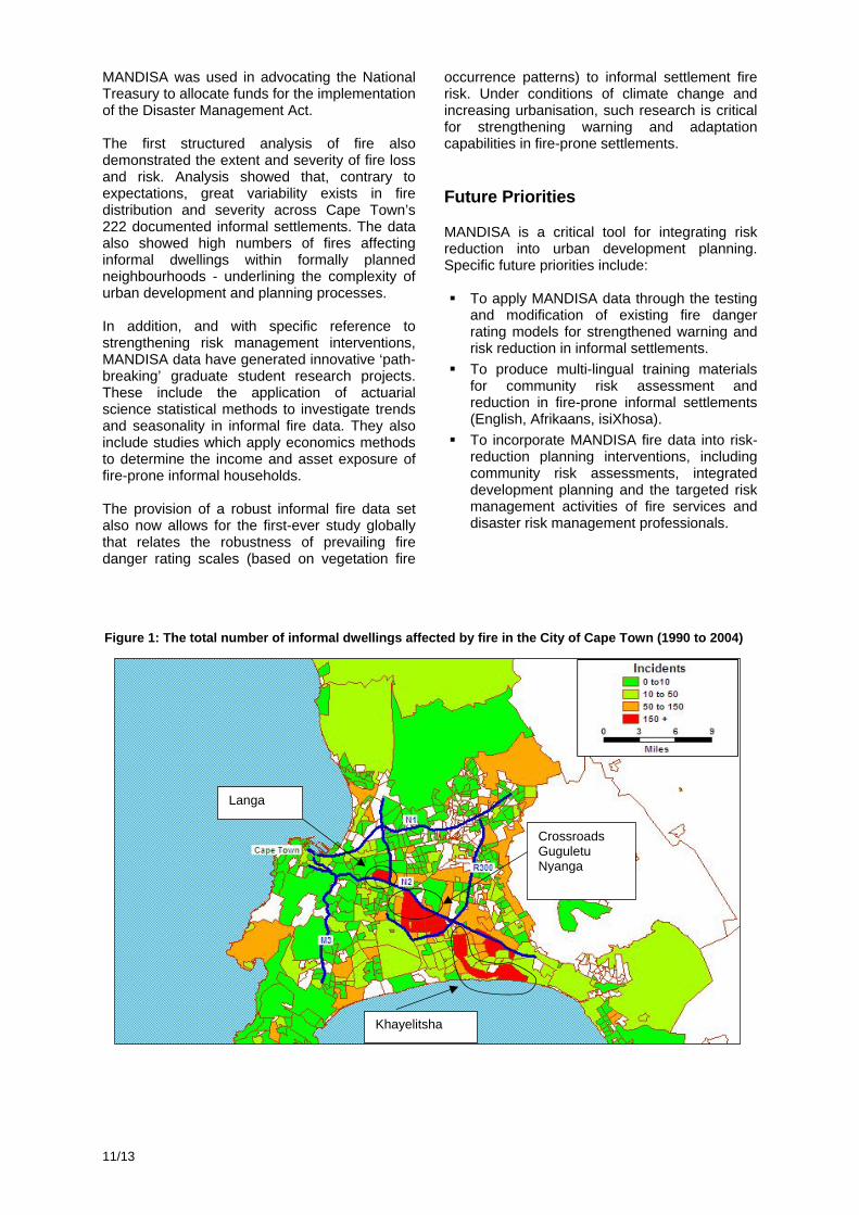
MANDISA was used in advocating the National Treasury to allocate funds for the implementation of the Disaster Management Act. The first structured analysis of fire also demonstrated the extent and severity of fire loss and risk. Analysis showed that, contrary to expectations, great variability exists in fire distribution and severity across Cape Town’s 222 documented informal settlements. The data also showed high numbers of fires affecting informal dwellings within formally planned neighbourhoods - underlining the complexity of urban development and planning processes. In addition, and with specific reference to strengthening risk management interventions, MANDISA data have generated innovative ‘path-breaking’ graduate student research projects. These include the application of actuarial science statistical methods to investigate trends and seasonality in informal fire data. They also include studies which apply economics methods to determine the income and asset exposure of fire-prone informal households. The provision of a robust informal fire data set also now allows for the first-ever study globally that relates the robustness of prevailing fire danger rating scales (based on vegetation fire
occurrence patterns) to informal settlement fire risk. Under conditions of climate change and increasing urbanisation, such research is critical for strengthening warning and adaptation capabilities in fire-prone settlements.
Future Priorities
MANDISA is a critical tool for integrating risk reduction into urban development planning. Specific future priorities include:
To apply MANDISA data through the testing and modification of existing fire danger rating models for strengthened warning and risk reduction in informal settlements.
To produce multi-lingual training materials for community risk assessment and reduction in fire-prone informal settlements (English, Afrikaans, isiXhosa).
To incorporate MANDISA fire data into risk-reduction planning interventions, including community risk assessments, integrated development planning and the targeted risk management activities of fire services and disaster risk management professionals.
Langa
Khayelitsha
Crossroads Guguletu Nyanga
Figure 1: The total number of informal dwellings affected by fire in the City of Cape Town (1990 to 2004)
12/13
Community initiatives in managing urbanisation and risk accumulation processes: Lessons from Dar es Salaam, Tanzania
By Team Leader Monoris Meshack, Principal Researchers Fred Lerise, John Lupala, Robert Kiunsi, and Assistant Researchers Emanuel Mchome, Benedict Malele, Ally Namangaya, University College of Lands and Architectural Studies, Dar es Salaam, Tanzania. Background
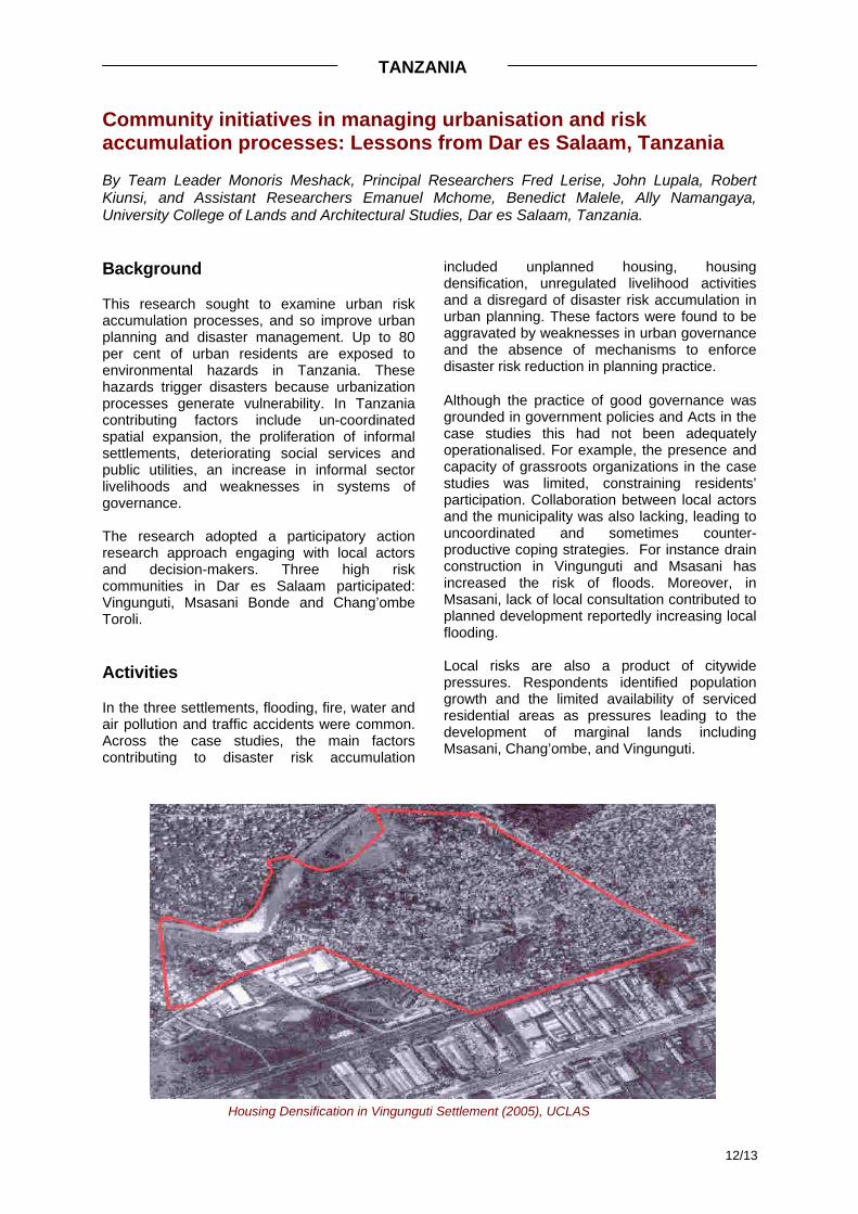
This research sought to examine urban risk accumulation processes, and so improve urban planning and disaster management. Up to 80 per cent of urban residents are exposed to environmental hazards in Tanzania. These hazards trigger disasters because urbanization processes generate vulnerability. In Tanzania contributing factors include un-coordinated spatial expansion, the proliferation of informal settlements, deteriorating social services and public utilities, an increase in informal sector livelihoods and weaknesses in systems of governance. The research adopted a participatory action research approach engaging with local actors and decision-makers. Three high risk communities in Dar es Salaam participated: Vingunguti, Msasani Bonde and Chang’ombe Toroli.
Activities
In the three settlements, flooding, fire, water and air pollution and traffic accidents were common. Across the case studies, the main factors contributing to disaster risk accumulation
included unplanned housing, housing densification, unregulated livelihood activities and a disregard of disaster risk accumulation in urban planning. These factors were found to be aggravated by weaknesses in urban governance and the absence of mechanisms to enforce disaster risk reduction in planning practice. Although the practice of good governance was grounded in government policies and Acts in the case studies this had not been adequately operationalised. For example, the presence and capacity of grassroots organizations in the case studies was limited, constraining residents’ participation. Collaboration between local actors and the municipality was also lacking, leading to uncoordinated and sometimes counter-productive coping strategies. For instance drain construction in Vingunguti and Msasani has increased the risk of floods. Moreover, in Msasani, lack of local consultation contributed to planned development reportedly increasing local flooding. Local risks are also a product of citywide pressures. Respondents identified population growth and the limited availability of serviced residential areas as pressures leading to the development of marginal lands including Msasani, Chang’ombe, and Vingunguti.
Housing Densification in Vingunguti Settlement (2005), UCLAS
TANZANIA
13/13
Individual coping strategies included seasonal migration, raised foundations of houses, using contacts to mobilise external support (municipality, development partners), boiling drinking water, promotion of environmental awareness on public health, using masks to avoid air pollution, drinking milk to ease respiratory problems and the burning of solid waste. At the community level, solid waste was collected. There was a strong willingness at the local level to undertake actions to reduce disaster risk, but this commitment was limited without partnership with the municipality and other external actors.
Future Priorities
Key ambitions for future work are to: 1. Implement disaster risk reduction projects
to demonstrate how urban development (planned and informal) can be undertaken with disaster risk reduction as a core principal.
2. Develop practical training tools for disaster
risk reduction in development planning for professionals and local actors.
3. Enhance local governance through using
risk reduction as a vehicle for strengthening community based organisations and their linkages with local government.
4. To explore the role of local businesses in
the generation of risk and how this might be mitigated.

The ProVention Consortium is a global coalition of international organisations, governments,
academic institutions, the private sector and civil society
organisations dedicated to reducing the risk and social, economic and environmental impacts of natural hazards on
vulnerable populations in developing countries.
5/20
07 E
200